New Progress of SinoProbe:
|
|
|
- Sherilyn Wheeler
- 5 years ago
- Views:
Transcription
1 New Progress of SinoProbe: Deep Exploration in China, Shuwen DONG, Tingdong LI, et al. Chinese Academy of Geological Sciences Beijing China


2 Background of Deep Exploration in World USA COCORP since1980s


3 (USArray) ( ) (SAFOD) (PBO)

4 EUROPROBE EuroProbe, was lasted 20 years, involved about 30 states and more than 1000 geoscientisits.


5 DECOPE DEKORP( Alps Transection

6 Rassia Transections and Deep Drillings


7 LithoProbe( )


8 AGCRC ( )

9 Deployment Map of SinoProbe ( ) GRN cells in China km 0 500km SinoProbe Deep Exploration in CHINA
10 Introduction to the SinoProbe The SinoProbe Deep Exploration in China, is a multidisciplinary earth science program in China, with the all aim to reveal the composition, structure and evolution of the continental lithosphere beneath Chinese continent, and promote capabilities of the scientific research and understanding of the Earth, exploration of natural resources, and early warning of geo-hazards.
11 Introduction to the SinoProbe The SinoProbe started in The first 5 years from is the initial phase of the SinoProbe, which is aimed at the testing of the feasibility of deep exploration technologies in geophysics, geochemistry, and continental deep drilling in China. The procedure of data collection and processing, and also the deep exploration instruments is developed in this phase. The other important goal is educating and training the new generation scientists for the launching of the SinoProbe program in full scale in the future. The total budget of the SinoProbe is ca. $200M for
12 Key Scientific Problems China occupies a large region of central and eastern Asia and holds key to resolve several first-order problems in Earth Sciences. Does continental lithosphere deform fundamentally in a plate-like or fluid-like fashion during continent-continent collision? Did the development of the Paleo- and Neo-Tethys and Paleo-Asia Oceans contribute to significant Phanerozoic production of continental crust in Earth's history? How did the uplift of the Qinghai-Tibet plateau control the regional and global climate change and biological evolution? How deformation of Tibet Plateau responded on driver from India and Western Pacific plates? What kind structure of lithosphere in east Asia influenced on formation and distribution of larger ore deposits and mechanism of earthquakes and geohazards?


13 Broad-band seismic stations with a total number of 585 and deploying length of 7300 km, paralleling to deep seismic reflection profiles. Deep seismic wide-angle reflection and refraction profiles with a total length of ca km. MT sounding with a total number of 1229 and length of 3300 km. Big Data: Nation-Wide Geophysical Data Deep seismic reflection profiles with a total length of ca km, crossing major orogens and basins in the Qinghai-Tibetan Plateau, the South China, the North China, and the Northeastern China. Up to 10 TB
14 Big Data: Nation-Wide Geophysical Data Dense 1 1 MT Standard Array observations: the North China (115 sites and 1386 physical points) and the Qinghai-Tibetan Plateau (88 sites and 874 physical points). Nation-wide 4 4 MT Standard Array observations: total 47 firstorder sites and 834 physical points.


15 Big Data: Nation-Wide Geochemical Data Nation-wide geochemical baseline framework with cell size in 160 km 160 km, and samples analyzed with 78 crustal elements.


16 Continental scientific drilling and anomaly verification at three ore districts, 2 plate boundaries, and 1 volcano: 11 holes, with total drill footage of >20000 m. Deep-hole stress measurement and monitoring: 15 holes. Petrophysical property measurement and experiment: 2300 samples. Total data base collected: up to 20 TB. Publication: 510 papers, with 150 SCI and 30 EI. Appling 90 patents, with 51 inventions and 18 new-types approved. Approved 21 software copyrights.


17 MT Array : Standard Continental Magnetotelluric Network North China 4º 4º in China Established high-precision observation procedure, precise and standard data-processing and inversion technique of the MT array standard grid By Wei W.B. et al., CUGB


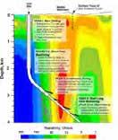
18 Regional Conductivity Map of North China By Wei W.B. et al., CUGB Depth of 5 km 2 km 5-15 km 1 1 network depths from 2 km to 250 km km km km


19 GRN cells GRN in China China geochemical baselines It has made a National-wide Geochemical Reference network, which is so-called China Geochemical Baselines with international standard. All the Crustal Elements, about 81 parameters covering 78 chemical elements, is analyzed at leading standard km 0 500km Global Geochemical Reference Network covering the mainland China By Wang X.Q. et al., CAGS

20 Experimentation of deep probing technologies and integration By Gao R. et al., IG, CAGS Proposed Deep Seismic Reflection Profiles Across China and Central and East Asia in the future 5000 km Deep Seismic Reflection Profiles were completed from 2008 to 2012 by SinoProbe -02.


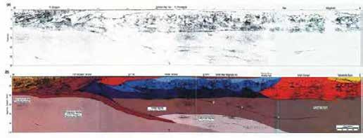
21 New constraints on crustal structure and Moho topography in Central Tibet revealed by SinoProbe deep seismic reflection profiling In the first time, the SinoProbe has got strong Deep Seismic Reflection of the Super-Thick Crust, Lower Crust and Moho Surface in the Hinterland of Qinghai-Tibet Plateau ~6.2 km Gao R. et al., 2013


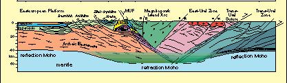
22 the Crust Imaging across West Qinling Orogenic belt Developing Technology of deep exploration for Chinese continent, such as combined deep seismic reflection and refraction profiling, especially for the crust in Orogenic belt and Craton, has been set up by SinoProbe. By Gao R. et al., IG, CAGS Indian Plate The Shorted all-crustal Imaging in North-East Tibet Sichuan Basin Wang et al., 2011; EPSL Detachment layer
Specific gravity field and deep crustal structure of the Himalayas east structural knot
 49 4 2006 7 CHINESE JOURNAL OF GEOPHYSICS Vol. 49, No. 4 Jul., 2006,,.., 2006, 49 (4) :1045 1052 Teng J W, Wang Q S, Wang GJ, et al. Specific gravity field and deep crustal structure of the Himalayas east
NAME HOMEWORK ASSIGNMENT #4 MATERIAL COVERS CHAPTERS 19, 20, 21, & 2
 NAME HOMEWORK ASSIGNMENT #4 MATERIAL COVERS CHAPTERS 19, 20, 21, & 2 Assignment is due the beginning of the class period on December 14, 2004. Mark answers on a scantron sheet, which will be provided.
SCIENCE CHINA Earth Sciences
 SCIENCE CHINA Earth Sciences RESEARCH PAPER September 2011 Vol.54 No.9: 1386 1393 doi: 10.1007/s11430-011-4177-2 Crustal P-wave velocity structure of the Longmenshan region and its tectonic implications
The continental lithosphere
 Simplicity to complexity: The continental lithosphere Reading: Fowler p350-377 Sampling techniques Seismic refraction Bulk crustal properties, thickness velocity profiles Seismic reflection To image specific
A BROADBAND SEISMIC EXPERIMENT IN YUNNAN, SOUTHWEST CHINA. Sponsored by Defense Threat Reduction Agency. Contract No.
 A BROADBAND SEISMIC EXPERIMENT IN YUNNAN, SOUTHWEST CHINA Wenjie Jiao, 1 Winston Chan, 1 and Chunyong Wang 2 Multimax Inc., 1 Institute of Geophysics, China Seismological Bureau 2 Sponsored by Defense
GEOPHYSICAL RESEARCH LETTERS, VOL. 37, L02304, doi: /2009gl041835, 2010
 Click Here for Full Article GEOPHYSICAL RESEARCH LETTERS, VOL. 37,, doi:10.1029/2009gl041835, 2010 Seismic structure of the Longmen Shan region from S wave tomography and its relationship with the Wenchuan
The San Andreas Fault Observatory at Depth: Recent Site Characterization Studies and the 2.2-Km-Deep Pilot Hole
 The San Andreas Fault Observatory at Depth: Recent Site Characterization Studies and the 2.2-Km-Deep Pilot Hole Steve Hickman and Bill Ellsworth (USGS) Mark Zoback (Stanford University) and the Pre-EarthScope
USU 1360 TECTONICS / PROCESSES
 USU 1360 TECTONICS / PROCESSES Observe the world map and each enlargement Pacific Northwest Tibet South America Japan 03.00.a1 South Atlantic Arabian Peninsula Observe features near the Pacific Northwest
Tomographic imaging of P wave velocity structure beneath the region around Beijing
 403 Doi: 10.1007/s11589-009-0403-9 Tomographic imaging of P wave velocity structure beneath the region around Beijing Zhifeng Ding Xiaofeng Zhou Yan Wu Guiyin Li and Hong Zhang Institute of Geophysics,
12. The diagram below shows the collision of an oceanic plate and a continental plate.
 Review 1. Base your answer to the following question on the cross section below, which shows the boundary between two lithospheric plates. Point X is a location in the continental lithosphere. The depth
200-kg large explosive detonation facing 50-km thick crust beneath west Qinling, northeastern Tibetan plateau
 389 Doi: 10.1007/s11589-009-0389-3 200-kg large explosive detonation facing 50-km thick crust beneath west Qinling, northeastern Tibetan plateau Qiusheng Li 1,2, Rui Gao 1,2 Haiyan Wang 1,2 Jisheng Zhang
Copyright McGraw-Hill Education. All rights reserved. No reproduction or distribution without the prior written consent of McGraw-Hill Education
 Copyright McGraw-Hill Education. All rights reserved. No reproduction or distribution without the prior written consent of McGraw-Hill Education Tibetan Plateau and Himalaya -southern Asia 11.00.a VE 10X
Directed Reading. Section: How Mountains Form MOUNTAIN RANGES AND SYSTEMS. Skills Worksheet
 Skills Worksheet Directed Reading Section: How Mountains Form 1. How high is Mount Everest? a. about 1980 km above sea level b. more than 8 km below sea level c. more than 8 km above sea level d. more
crustal structure experiment beneath Wairarapa - Wellington area: results from SAHKE
 crustal structure experiment beneath Wairarapa - Wellington area: results from SAHKE Tim Stern and SAHKE team* * VUW, GNS, University of Southern California, University of Tokyo(Japan) SAHKE = Seismic
Mantle anisotropy across the southwestern boundary of the Ordos block, North China
 Earthq Sci (200)23: 549 553 549 Doi: 0.007/s589-00-0754-2 Mantle anisotropy across the southwestern boundary of the Ordos block, North China, Yongcai Tang Yongshun John Chen Yuanyuan V. Fu 2 Haiyang Wang
Grand Unifying Theory of everything... for the Geosciences, at least!
 Plate Tectonics: Grand Unifying Theory of everything... for the Geosciences, at least! The Earth s lithosphere, composed of Oceanic and continental crust, is broken up into pieces that move and interact
Earth Systems Science Chapter 7. Earth Systems Science Chapter 7 11/11/2010. Seismology: study of earthquakes and related phenomena
 Earth Systems Science Chapter 7 I. Structure of the Earth II. Plate Tectonics The solid part of the earth system includes processes, just like the atmosphere and oceans. However, the time scales for processes
Section 2: How Mountains Form
 Section 2: How Mountains Form Preview Objectives Mountain Ranges and Systems Plate Tectonics and Mountains Types of Mountains Objectives Identify the types of plate collisions that form mountains. Identify
Evolution of Continents Chapter 20
 Evolution of Continents Chapter 20 Does not contain complete lecture notes. Mountain belts Orogenesis the processes that collectively produce a mountain belt Includes folding, thrust faulting, metamorphism,
Predictive Mineral Discovery the Yilgarn gold story.. by Y4-A3-M9-F6 Project Members. predictive mineral discovery Cooperative Research Centre
 Predictive Mineral Discovery the Yilgarn gold story.. by Y4-A3-M9-F6 Project Members Continent Y4-A3-M9-F6 Craton Province Camp-district Deposit SESSION: YILGARN 11:20 Bruce Goleby Y4) Big system big picture:
Dr. Yildirim Dilek Department of Earth Sciences Miami University, USA
 Dr. Yildirim Dilek Department of Earth Sciences Miami University, USA 40 years of successful, field-based, inter-disciplinary exploration of the Earth processes and training of the future generations of
A study on crustal structures of Changbaishan2Jingpohu volcanic area using receiver functions
 48 2 2005 3 CHINESE JOURNAL OF GEOPHYSICS Vol. 48, No. 2 Mar., 2005,,..,2005,48 (2) :352 358 Duan Y H, Zhang X K, Liu Z,et al. A study on crustal structures of Changbaishan2Jingpohu volcanic area using
Three-dimensional thermal structure of the Chinese continental crust and upper mantle
 Science in China Series D: Earth Sciences 2007 SCIENCE IN CHINA PRESS Springer Three-dimensional thermal structure of the Chinese continental crust and upper mantle AN MeiJian 1,2 & SHI YaoLin 1 1 Laboratory
Middle and upper crust shear-wave velocity structure of the Chinese mainland
 Vol.20 No.4 (359~369) ACTA SEISMOLOGICA SINICA July, 2007 Article ID: 1000-9116(2007)04-0359-11 doi: 10.1007/s11589-007-0359-6 Middle and upper crust shear-wave velocity structure of the Chinese mainland
Mountain Building. Mountain Building
 Mountain Building Mountain building has occurred during the recent geologic past American Cordillera the western margin of the Americas from Cape Horn to Alaska Includes the Andes and Rocky Mountains Alpine
Late 20 th Century Tests of the Continental Drift Hypothesis
 Late 20 th Century Tests of the Continental Drift Hypothesis 5 Characteristics of the Ocean Trenches Unless otherwise noted the artwork and photographs in this slide show are original and by Burt Carter.
Global Tectonics. Kearey, Philip. Table of Contents ISBN-13: Historical perspective. 2. The interior of the Earth.
 Global Tectonics Kearey, Philip ISBN-13: 9781405107778 Table of Contents Preface. Acknowledgments. 1. Historical perspective. 1.1 Continental drift. 1.2 Sea floor spreading and the birth of plate tectonics.
GEO-DEEP9300 Lithosphere and Asthenosphere: Composition and Evolution
 GEO-DEEP9300 Lithosphere and Asthenosphere: Composition and Evolution Summary Presentation The Structural Evolution of the Deep Continental Lithosphere Focused on the Junction of Arabian, Eurasian and
FORCES ON EARTH. An investigation into how Newton s Laws of Motion are applied to the tectonic activity on Earth.
 FORCES ON EARTH An investigation into how Newton s Laws of Motion are applied to the tectonic activity on Earth. GEOLOGY Geologists scientists who study the forces that make and shape the Earth Geologists
A) B) C) D) 4. Which diagram below best represents the pattern of magnetic orientation in the seafloor on the west (left) side of the ocean ridge?
 B) C) D) 4. Which diagram below best represents the pattern of magnetic orientation in the seafloor on the west (left) side of the ocean ridge?") 1. Crustal formation, which may cause the widening of an ocean, is most likely occurring at the boundary between the A) African Plate and the Eurasian Plate B) Pacific Plate and the Philippine Plate C)
1. Crustal formation, which may cause the widening of an ocean, is most likely occurring at the boundary between the A) African Plate and the Eurasian Plate B) Pacific Plate and the Philippine Plate C)
Earth Science, (Tarbuck/Lutgens) Chapter 10: Mountain Building
 Chapter 10: Mountain Building") Earth Science, (Tarbuck/Lutgens) Chapter 10: Mountain Building 1) A(n) fault has little or no vertical movements of the two blocks. A) stick slip B) oblique slip C) strike slip D) dip slip 2) In a(n) fault,
Earth Science, (Tarbuck/Lutgens) Chapter 10: Mountain Building 1) A(n) fault has little or no vertical movements of the two blocks. A) stick slip B) oblique slip C) strike slip D) dip slip 2) In a(n) fault,
SEISMIC VELOCITY STRUCTURE OF THE NORTHWESTERN & NORTHEASTERN HIMALAYA AND ITS IMPLICATIONS FOR EARTHQUAKE HAZARD ASSESSMENT
 SEISMIC VELOCITY STRUCTURE OF THE NORTHWESTERN & NORTHEASTERN HIMALAYA AND ITS IMPLICATIONS FOR EARTHQUAKE HAZARD ASSESSMENT UKIERI Thematic Partnership Supriyo Mitra Keith Priestley Motivation ~50 Ma
Geophysical Journal International
 Geophysical Journal International Geophys. J. Int. (2017) 210, 303 320 Advance Access publication 2017 April 26 GJI Seismology doi: 10.1093/gji/ggx163 Tectonic history of the Ordos Block and Qinling Orogen
GD3.3/GM3.3/GMPV16/TS4.7
 GD Geodynamics Orals and PICOs MO1, 08:30 10:00 MO2, 10:30 12:00 MO3, 13:30 15:00 MO4, 15:30 17:00 TU1, 08:30 10:00 TU2, 10:30 12:00 TU3, 13:30 15:00 Monday, 08 April Medal Lecture) (co-organized), 08:30
Essentials of Geology, 11e
 Essentials of Geology, 11e Crustal Deformation and Mountain Building Chapter 17 Instructor Jennifer Barson Spokane Falls Community College Geology 101 Stanley Hatfield Southwestern Illinois College Jennifer
A BROADBAND SEISMIC EXPERIMENT IN YUNNAN, SOUTHWEST CHINA. Sponsored by Defense Threat Reduction Agency. Contract No.
 A BROADBAND SEISMIC EXPERIMENT IN YUNNAN, SOUTHWEST CHINA Wenjie Jiao, 1 Winston Chan, 1 and Chunyong Wang 2 Multimax Inc., 1 Institute of Geophysics, China Seismological Bureau 2 Sponsored by Defense
Imaging Moho topography beneath the Alps by multdisciplinary seismic tomography
 Imaging Moho topography beneath the Alps by multdisciplinary seismic tomography Edi Kissling ETH Zürich SPP short course February 1+2, 218, Berlin, Germany Alpine Moho map from CSS Moho uncertainty derived
Plate Tectonics 3. Where Does All the Extra Crust Go?
 Plate Tectonics 3 Where Does All the Extra Crust Go? Unless otherwise noted the artwork and photographs in this slide show are original and by Burt Carter. Permission is granted to use them for non-commercial,
The Tectonic Setting of New Zealand
 The Tectonic Setting of New Zealand we are here Subduction-driven tectonics The New Zealand continent Papua New Guinea Australia 3,000,000 sq km micro-continent back-arc basin trench volcanism faults accretionary
Earth Movement and Resultant Landforms
 Earth Movement and Resultant Landforms Structure of the Earth Lithosphere : earth s crust Asthenosphere : upper mantle zone where material is near its melting point & acts almost like liquid (appprox.
USArray the first five years
 www.earthscope.org USArray the first five years USArray A Continental-Scale Seismic By the Numbers (2003 2008) More than 600 Transportable Array sites have been occupied and more than 535 permits acquired
SMART NOTES ON INDIAN GEOGRAPHY - 1
 ON INDIAN GEOGRAPHY - 1 Point. Precise. Powerful. www.thesmartnotes.org ON INDIAN GEOGRAPHY - 1 To our Hardworking and persistence aspirants. Success is going from failure to failure without losing enthusiasm.
Plate Tectonics. I. The Discovery of Plate Tectonics II. A Mosaic of Plates III. Types of Plate Boundaries IV. How Plates Move
 Plate Tectonics I. The Discovery of Plate Tectonics II. A Mosaic of Plates III. Types of Plate Boundaries IV. How Plates Move I. The Discovery of Plate Tectonics A. Continental Drift (Alfred Wegener) Proposed
Learning Objectives (LO)! Lecture 11: Plate Tectonics II! No Homework!! ** Chapter 3 **! What we ll learn today:!
! Lecture 11: Plate Tectonics II! No Homework!! ** Chapter 3 **! What we ll learn today:!") Learning Objectives (LO)! Lecture 11: Plate Tectonics II! No Homework!! ** Chapter 3 **! What we ll learn today:! 1. List the three types of tectonic plate boundaries! 2. Describe the processes occurring
Learning Objectives (LO)! Lecture 11: Plate Tectonics II! No Homework!! ** Chapter 3 **! What we ll learn today:! 1. List the three types of tectonic plate boundaries! 2. Describe the processes occurring
CURRICULUM VITAE WEISEN SHEN EDUCATION
 CURRICULUM VITAE WEISEN SHEN Center for Imaging the Earth s Interior, Department of Physics, CU Boulder Boulder, CO, 80309 Research ID: J-3969-2012 http://www.researcherid.com/rid/j-3969-2012 Citizenship:
Chapter 02 The Sea Floor
 Chapter 02 The Sea Floor Multiple Choice Questions 1. One of the following is not one of the world's major ocean basins: A. Atlantic Ocean B. Arctic Ocean C. Indian Ocean D. Antarctic Ocean E. Pacific
Earth s Continents and Seafloors. GEOL100 Physical Geology Ray Rector - Instructor
 Earth s Continents and Seafloors GEOL100 Physical Geology Ray Rector - Instructor OCEAN BASINS and CONTINENTAL PLATFORMS Key Concepts I. Earth s rocky surface covered by of two types of crust Dense, thin,
FORCES ON EARTH UNIT 3.2. An investigation into how Newton s Laws of Motion are applied to the tectonic activity on Earth.
 FORCES ON EARTH UNIT 3.2 An investigation into how Newton s Laws of Motion are applied to the tectonic activity on Earth. USE THESE NOTES: OUR HOME PLANET EARTH: What do you know about our planet? SO.HOW
The Structure of the Earth and Plate Tectonics
 The Structure of the Earth and Plate Tectonics Agree or Disagree? 1. The Earth if made up of 4 different layers. 2. The crust (where we live) can be made of either less dense continental crust or the more
ANOTHER MEXICAN EARTHQUAKE! Magnitude 7.1, Tuesday Sept. 19, 2017
 ANOTHER MEXICAN EARTHQUAKE! Magnitude 7.1, Tuesday Sept. 19, 2017 Why is there no oceanic crust older than 200 million years? SUBDUCTION If new oceanic crust is being continuously created along the earth
Dynamic Earth Quiz. 4. The accompanying diagram shows some features of Earth s crust and upper mantle.
 DO NOT WRITE ON THIS Dynamic Earth Quiz DO NOT WRITE ON THIS 1. Base your answer(s) to the following question(s) on the diagram below. The diagram shows a model of the relationship between Earth s surface
the IRIS Consortium Collaborative, Multi-user Facilities for Research and Education Briefing NSF Business Systems Review September 9, 2008
 the IRIS Consortium Collaborative, Multi-user Facilities for Research and Education Briefing NSF Business Systems Review September 9, 2008 A facilities program for collection and distribution of seismological
Earth Science Lesson 3 Dynamic Earth Processes (Grades 8-12 ) Instruction 3-3 Plate Boundaries
 Instruction 3-3 Plate Boundaries") As we told you in a recent Instruction, much of the Earth's lithosphere (its Crust and the top layer of its Outer Mantle) is made up of moving masses of rock called tectonic plates (tectonic means moving).
As we told you in a recent Instruction, much of the Earth's lithosphere (its Crust and the top layer of its Outer Mantle) is made up of moving masses of rock called tectonic plates (tectonic means moving).
Prentice Hall EARTH SCIENCE
 Prentice Hall EARTH SCIENCE Tarbuck Lutgens Chapter 9 Plate Tectonics 9.1 Continental Drift An Idea Before Its Time Wegener s continental drift hypothesis stated that the continents had once been joined
Prentice Hall EARTH SCIENCE
 Prentice Hall EARTH SCIENCE Tarbuck Lutgens Chapter 9 Plate Tectonics 9.1 Continental Drift An Idea Before Its Time Wegener s continental drift hypothesis stated that the continents had once been joined
Earthscope in the Northern Rockies Workshop
 Earthscope in the Northern Rockies Workshop Co-conveners: David Foster - University of Florida Paul Mueller - University of Florida David Mogk - Montana State University EarthScope in the Northern Rockies
International workshop on New Observations on the. Deep Structure beneath the Alps-Anatolia-Iran Regions. 2nd Announcement
 International workshop on New Observations on the Deep Structure beneath the Alps-Anatolia-Iran Regions 28-30, May, 2014 Beijing 2nd Announcement Major itinerary plan State Kay Laboratory of Lithospheric
An Introduction of Aleutian Subduction Zone. Chuanmao Yang, Hong Yang, Meng Zhang, Wenzhong Wang 2016/04/29
 An Introduction of Aleutian Subduction Zone Chuanmao Yang, Hong Yang, Meng Zhang, Wenzhong Wang 2016/04/29 Outline General Introduction Formation history Structure from seismic study geochemical features
Our Dynamic Earth Unit Unit 5
 EARTH SCIENCE REGENTS - SOTO Our Dynamic Earth Unit Unit 5 Mr. Soto - Key 1/1/2013 Our Dynamic Earth Vocabulary List 1 Directions: Define each vocabulary word provided below. You may have to use your Earth
The Theory of Plate Tectonics
 Plate Tectonics Objectives Describe how plates move. Explain the features of plate tectonics. Describe the types of plate boundaries and the features that can form and events that can occur at each. The
Research on the Spatial Distribution Characteristics of b-value in Southwest Yunnan
 International Symposium on Computers & Informatics (ISCI 2015) Research on the Spatial Distribution Characteristics of b-value in Southwest Yunnan XIE ZHUOJUAN1, a, LU YUEJUN1, b 1Institute of Crustal
Before Plate Tectonics: Theory of Continental Drift
 Before Plate Tectonics: Theory of Continental Drift Predecessor to modern plate tectonics Shape and fit of the continents was the initial evidence Snider-Pelligrini (1858) Taylor (1908) Wegner (1915) Fig.
TS Tectonics & Structural Geology Orals and PICOs Monday, 08 April
 TS Tectonics & Structural Geology Orals and PICOs Monday, 08 April MO1, 08:30 10:00 MO2, 10:30 12:00 MOL, 12:15 13:15 MO3, 13:30 15:00 MO4, 15:30 17:00 GD3.3/GM3.3/GMPV16/TS4.7, The evolution of plate
Chapter. Graphics by Tasa Graphic Arts. Inc.
 Earth Chapter Plate Science 9 Tectonics Graphics by Tasa Graphic Arts. Inc. 1 I. Earth s surface is made up of lithospheric plates. A. Lithospheric plates are composed of the crust and part of the upper
Continental Drift and Plate Tectonics
 Continental Drift and Plate Tectonics Continental Drift Wegener s continental drift hypothesis stated that the continents had once been joined to form a single supercontinent. Wegener proposed that the
60% water. Big Bang: 14,000 millions years ago The Earth originated about 4,500 millions years ago its orbit allows water to exist in a liquid state!
 Ch2. The Sea Floor #1 Why geology of the oceans? Marine habitats are directly shaped by geological processes The form of the coastlines The depth of the water Type of bottom (muddy, sandy, rocky) #2 Geological
entered a rapid development phase. Annual increased proven reserves are above 500 billion cubic meters (bcm) from 2003, and annual natural gas product
 from 2003, and annual natural gas product") (), entered a rapid development phase. Annual increased proven reserves are above 500 billion cubic meters (bcm) from 2003, and annual natural gas production has increased from 50bcm in 2000 to nearly
(), entered a rapid development phase. Annual increased proven reserves are above 500 billion cubic meters (bcm) from 2003, and annual natural gas production has increased from 50bcm in 2000 to nearly
North America subducted under Rubia. Are there modern analogs for Hildebrand s model of North America subducting under Rubia?
 North America subducted under Rubia Are there modern analogs for Hildebrand s model of North America subducting under Rubia? In the Geological Society of America Special Papers Did Westward Subduction
In the space provided, write the letter of the definition that best matches the term or phrase.
 Skills Worksheet Directed Reading Section: The Changing Continents 1. What is the result of slow movements of tectonic plates? RESHAPING EARTH S CRUST In the space provided, write the letter of the definition
3. PLATE TECTONICS LAST NAME (ALL IN CAPS): FIRST NAME: PLATES
: FIRST NAME: PLATES") LAST NAME (ALL IN CAPS): FIRST NAME: PLATES 3. PLATE TECTONICS The outer layers of the Earth are divided into the lithosphere and asthenosphere. The division is based on differences in mechanical properties
LAST NAME (ALL IN CAPS): FIRST NAME: PLATES 3. PLATE TECTONICS The outer layers of the Earth are divided into the lithosphere and asthenosphere. The division is based on differences in mechanical properties
Magnetotelluric data from the Tien Shan and Pamir continental collision zones, Central Asia
 Magnetotelluric data from the Tien Shan and Pamir continental collision zones, Central Asia P. Sass*, O. Ritter*, A. Rybin**, G. Muñoz*, V. Batalev** and M. Gil* *Helmholtz Centre Potsdam GFZ, German Research
Introduction To Plate Tectonics Evolution. (Continents, Ocean Basins, Mountains and Continental Margins)
") Introduction To Plate Tectonics Evolution (Continents, Ocean Basins, Mountains and Continental Margins) Geo 386 (Arabian Shield Course) Dr. Bassam A. A. Abuamarah Mohanna G E O 3 8 6 A R A B I A N G E
Introduction To Plate Tectonics Evolution (Continents, Ocean Basins, Mountains and Continental Margins) Geo 386 (Arabian Shield Course) Dr. Bassam A. A. Abuamarah Mohanna G E O 3 8 6 A R A B I A N G E
PLATE TECTONICS. Continental Drift. Continental Drift. Continental Drift. Continental Drift- Wegener s Evidence
 Continental Drift PLATE TECTONICS E.B. Taylor (1910) and Alfred Wegener (1915) published on Continental Drift. Continental Drift Wegener s evidence 1. Fit of the Continents 2. Fossil Evidence 3. Rock Type
Lecture Outlines PowerPoint. Chapter 10 Earth Science, 12e Tarbuck/Lutgens
 Lecture Outlines PowerPoint Chapter 10 Earth Science, 12e Tarbuck/Lutgens 2009 Pearson Prentice Hall This work is protected by United States copyright laws and is provided solely for the use of instructors
Topic 5: The Dynamic Crust (workbook p ) Evidence that Earth s crust has shifted and changed in both the past and the present is shown by:
 Evidence that Earth s crust has shifted and changed in both the past and the present is shown by:") Topic 5: The Dynamic Crust (workbook p. 65-85) Evidence that Earth s crust has shifted and changed in both the past and the present is shown by: --sedimentary horizontal rock layers (strata) are found
Topic 5: The Dynamic Crust (workbook p. 65-85) Evidence that Earth s crust has shifted and changed in both the past and the present is shown by: --sedimentary horizontal rock layers (strata) are found
27th Seismic Research Review: Ground-Based Nuclear Explosion Monitoring Technologies
 P AND S WAVE VELOCITY STRUCTURE OF THE CRUST AND UPPER MANTLE UNDER CHINA AND SURROUNDING AREAS FROM BODY AND SURFACE WAVE TOMOGRAPHY M. Nafi Toksöz, Robert D. Van der Hilst, Youshun Sun, and Chang Li
Fig Available seismic reflection, refraction, and magnetic profiles from 107 the Offshore Indus Basin close to the representative profile GCDH,
 List of Figures Page No. Fig. 1.1 Generalized physiography of the Indian Ocean along with 2 selected (200 m, 1000 m, 2000 m, and 3000 m) bathymetric contours. Fig. 1.2 Lithospheric plates in the Indian
Theory of Continental Drift
 Plate Tectonics Theory of Continental Drift Alfred Wegener suggested that continents had once been part of a supercontinent named Pangaea, that later broke up. The pieces moved apart over millions of years
Deformation of Rocks. Orientation of Deformed Rocks
 Deformation of Rocks Folds and faults are geologic structures caused by deformation. Structural geology is the study of the deformation of rocks and its effects. Fig. 7.1 Orientation of Deformed Rocks
COMPOSITION and PHYSICAL PROPERTIES GENERAL SUBJECTS. GEODESY and GRAVITY
 COMPOSITION and PHYSICAL PROPERTIES Composition and structure of the continental crust Composition and structure of the core Composition and structure of the mantle Composition and structure of the oceanic
Marine Science and Oceanography
 Marine Science and Oceanography Marine geology- study of the ocean floor Physical oceanography- study of waves, currents, and tides Marine biology study of nature and distribution of marine organisms Chemical
Introduction to: The Rocky Mountain Region An Evolving Lithosphere: Tectonics, Geochemistry, and Geophysics
 Introduction to: The Rocky Mountain Region An Evolving Lithosphere: Tectonics, Geochemistry, and Geophysics Karl E. Karlstrom Department of Earth and Planetary Sciences, University of New Mexico, Albuquerque,
PLATE TECTONICS REVIEW GAME!!!!
 PLATE TECTONICS REVIEW GAME!!!! Name the four layers of the earth - crust - mantle - outer core - inner core Which part of Earth s structure contains tectonic plates? LITHOSPHERE Name one reason why the
A GROUND-TRUTH DATABASE FOR CENTRAL CHINA. W. Winston Chan and Xiaoxi Ni Multimax, Inc.
 A GROUND-TRUTH DATABASE FOR CENTRAL CHINA W. Winston Chan and Xiaoxi Ni Multimax, Inc. Sponsored by U.S. Department of Energy Office of Nonproliferation Research and Engineering Office of Defense Nuclear
Convergent plate boundaries. Objective to be able to explain the formation and key features of these zones.
 Convergent plate boundaries Objective to be able to explain the formation and key features of these zones. Destructive plate margins When plates collide due to convection currents/slab pull in the asthenosphere
S-wave velocity structure beneath Changbaishan volcano inferred from receiver function
 Earthq Sci (2009)22: 409 416 409 Doi: 10.1007/s11589-009-0409-3 S-wave velocity structure beneath Changbaishan volcano inferred from receiver function Jianping Wu Yuehong Ming Lihua Fang Weilai Wang Institute
GENERAL GEOLOGY Fall Chapter 18: The Sea Floor. Partial Examination IV Study Guide Dr. Glen S. Mattioli
 GENERAL GEOLOGY 1113-005 Fall 2008 Partial Examination IV Study Guide Dr. Glen S. Mattioli Note that these are NOT questions, but rather are a list of topics that we have covered either in class or are
Crustal Boundaries. As they move across the asthenosphere and form plate boundaries they interact in various ways. Convergent Transform Divergent
 Name: Date: Period: Plate Tectonics The Physical Setting: Earth Science CLASS NOTES Tectonic plates are constantly moving and interacting As they move across the asthenosphere and form plate boundaries
The Dynamic Crust 2) 4) Which diagram represents the most probable result of these forces? 1)
 4) Which diagram represents the most probable result of these forces? 1)") 1. The diagrams below show cross sections of exposed bedrock. Which cross section shows the least evidence of crustal movement? 1) 3) 4. The diagram below represents a section of the Earth's bedrock. The
1. The diagrams below show cross sections of exposed bedrock. Which cross section shows the least evidence of crustal movement? 1) 3) 4. The diagram below represents a section of the Earth's bedrock. The
Beneath our Feet: The 4 Layers of the Earty by Kelly Hashway
 Beneath our Feet: The 4 Layers of the Earty by Kelly Hashway The Earth is more than a giant ball made up of dirt, rocks, and minerals. The Earth may look like a giant ball from when looking at it from
Strike-Slip Faults. ! Fault motion is parallel to the strike of the fault.
 Strike-Slip Faults! Fault motion is parallel to the strike of the fault.! Usually vertical, no hanging-wall/footwall blocks.! Classified by the relative sense of motion. " Right lateral opposite block
Unit Topics. Topic 1: Earth s Interior Topic 2: Continental Drift Topic 3: Crustal Activity Topic 4: Crustal Boundaries Topic 5: Earthquakes
 The Dynamic Earth Unit Topics Topic 1: Earth s Interior Topic 2: Continental Drift Topic 3: Crustal Activity Topic 4: Crustal Boundaries Topic 5: Earthquakes Topic 1: Earth s Interior Essential Question:
Chapter 2. The Planet Oceanus
 Chapter 2 The Planet Oceanus Composition of the Earth The Earth consists of a series of concentric layers or spheres which differ in chemistry and physical properties. There are two different ways to describe
Plate Tectonics. entirely rock both and rock
 Plate Tectonics I. Tectonics A. Tectonic Forces are forces generated from within Earth causing rock to become. B. 1. The study of the origin and arrangement of Earth surface including mountain belts, continents,
Name Class Date. 1. What is the outermost layer of the Earth called?. a. core b. lithosphere c. asthenosphere d. mesosphere
 Name Class Date Assessment Geology Plate Tectonics MULTIPLE CHOICE Write the letter of the correct answer in the space provided. 1. What is the outermost layer of the Earth called?. a. core b. lithosphere
Plate Tectonics GEOL 101 Lecture 22 How Are Mountains Built?
 Plate Tectonics GEOL 101 Lecture 22 How Are Mountains Built? The Grand Tetons, Wyoming First a Brief Review of Sea Floor Spreading Prop: Test 3 Invitations Break-Up of a Continent and Origin of an Ocean
Chapter Two. Figure 02_02. Geography of the Ocean Basins. The Sea Floor
 Chapter Two The Sea Floor Geography of the Ocean Basins Figure 02_02 The world ocean is the predominant feature on the Earth in total area. In the Northern Hemisphere, 61% of the total area is ocean. In
DEFORMATION KINEMATICS OF TIBETAN PLATEAU DETERMINED FROM GPS OBSERVATIONS
 DEFORMATION KINEMATICS OF TIBETAN PLATEAU DETERMINED FROM GPS OBSERVATIONS Jinwei Ren Institute of Geology, China Seismological Bureau, Beijing 100029 China Tel: (10)62009095; Fax: (10)62009003; email:
CONTINENTAL PLATE BOUNDARY ZONES
 CONTINENTAL PLATE BOUNDARY ZONES Plate boundaries initially viewed as narrow Now recognize that many plate boundaries - especially continental - are deformation zones up to 1000 km wide, with motion spread
Mountains and Mountain Building: Chapter 11
 Mountains and Mountain Building: Chapter 11 Objectives: 1)Explain how some of Earth s major mountain belts formed 2) Compare and contrast active and passive continental margins 3) Explain how compression,