|
|
|
- Clara Harvey
- 5 years ago
- Views:
Transcription
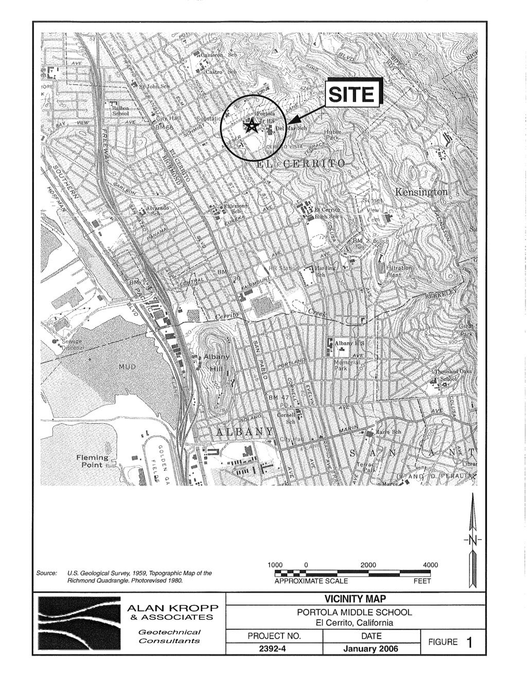
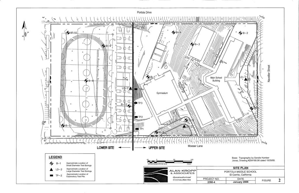
1
2
3
4
5
6
7
8
9
10
11
12
13
14
15
16
17 TP-1 N61E 0 DARK BROWN SANDY SILT (ML) stiff, wet with roots (Disturbed Surficial Soil) DEPTH (FEET) 5 REDDISH BROWN SANDSTONE intensely fractured, weak to friable, deeply weathered, tight (Franciscan Assemblage) TP-2 DEPTH (FEET) GRAYISH BROWN AND GRAY MELANGE, friable to plastic, crushed, deeply weathered, mainly decomposed to clay, stiff, wet, with roots (Landslide Debris) 1/2 layer of gray clay, stiff, wet with polished parting, subhorizontal (Landslide Plane) N61E GRAYISH BROWN AND GRAY MELANGE, friable to plastic, crushed, deeply weathered (Franciscan Assemblage) DARK BROWN SANDY SILT (ML) stiff, wet with roots (Disturbed Surficial Soil) RED AND GRAY MELANGE consisting of plastic shale with fragments of sandstone, pervasively sheared (Franciscan Assemblage) Shear zone - 4 thick zone of reddish brown clay with polished SCALE IN FEET 20 ALAN KROPP & ASSOCIATES JOYCE ASSOCIATES Logs of Test Pits TP-1 and TP-2 Portola Middle School El Cerrito, California
18 TP-3 0 DARK BROWN SANDY SILT (ML) stiff, wet, with roots (Disturbed Surficial Soil) N61E 1 seam of olive gray clay with polished parting, subhorizontal (Landslide Plane) DEPTH (FEET) 5 10 DARK BROWN SANDY SILT (ML) stiff, wet with roots (Disturbed Surficial Soil) Curb Play Ground RED AND GRAY MELANGE, consisting of plastic shale with fragments of sandstone, pervasively sheared (Landslide Debris) 15 Landslide N30W10SW with OLIVE BROWN AND REDDISH BROWN GRAVELLY SILTY CLAY (CL) very stiff, wet (Landslide Debris) GRAYISH BROWN AND GRAY MELANGE, friable to plastic, crushed, deeply weathered (Franciscan Assemblage) 20 TP-4 N61E 0 OLIVE BROWN AND REDDISH BROWN GRAVELLY SILTY CLAY (CL) very stiff, wet (Landslide Debris) DEPTH (FEET) 5 GRAY SANDY SILT (ML) very stiff, wet, with occasional vertical fissures (Paleosol) Curb Play Ground 10 4 thick zone of olive gray clay with polished parting, very stiff, wet (Landslide Plane) YELLOWISH BROWN SANDSTONE, closely to intensely fractured, friable, deeply to severly weathered, tight (Franciscan Assemblage) SCALE IN FEET 20 ALAN KROPP & ASSOCIATES JOYCE ASSOCIATES Logs of Test Pits TP-3 and TP-4 Portola Middle School El Cerrito, California
19 Log of Boring LD-1 Depth Feet Graphic Log (In cut area - surficial soil removed by cut) Portola Middle Project Name School Job Number Drilling Method 24 Bucket Auger Description Location El Cerrito, CA Date Completed 02/23/05 Depth 53 ft. Elevation 219 ft 5 REDDISH BROWN GRAVELLY CLAY (CH), very stiff to hard, moist, with rare roots; gravels are angular Franciscan rock fragments (Landslide Debris) Slight seepage Slight seepage 10 Becomes saturated with moderate seepage, locally grades to clayey gravel 15 Becomes stiff to very stiff, gravel is greater than 50% 20 Contact approximately N10E35E with gray clay seam (Landslide plane) MIXED DARK BROWN GRAVELLY CLAY AND LIGHT YELLOWISH BROWN GRAVELLY CLAY AND YELLOWISH BROWN SILTY CLAY (CL), very stiff, wet, with angular rock fragments (Landslide Debris) Includes semi-intact rock masses of YELLOWISH BROWN SILTY SANDSTONE, closely fractured 25 Grades to mainly DARK BROWN SANDY SILT(ML) hard, moist, with rock fragments; with intermixed YELLOWISH BROWN SANDY SILT AND CLAY (ML-CL) chaotic texture (Landslide Debris) N15W38NE sharp, (Landslide plane) with polished parting YELLOWISH BROWN CLAYEY SILT, hard, moist, tight, 1/2 thick clay seam and polished N63W25SW (Landslide Plane) LIGHT TO DARK GRAYISH BROWN GRAVELLY CLAY (CL), very stiff, wet, with angular gravels (Landslide Debris) Locally grades to GRAY GRAVELLY SILTY CLAY, very stiff, wet Zone of rock. SILICOUS YELLOWISH BROWN SANDSTONE. Very hard, appears disturbed, disarticulated (Landslide Debris) With steeply dipping shears With disarticulated rock zones Gradational Contact DARK BROWNISH GRAY GRAVELLY CLAY (CL) very stiff, wet, with angular gravels (Landslide Debris) 40 ALAN KROPP & ASSOCIATES JOYCE ASSOCIATES Log of Boring LD-1 Portola Middle School El Cerrito, California
20 Log of Boring LD-1 Depth Feet Graphic Log Portola Middle Project Name School Job Number Drilling Method 24 Bucket Auger Description DARK BROWNISH GRAY GRAVELLY CLAY (as above) Location El Cerrito, CA Date Completed 02/03/05 Depth 53 ft. Elevation 219 ft Becomes stiff, saturated Contact: Slide Plane, dark gray clay (CH), 1 thick, stiff, with polished partings, BROWN AND GRAY GRAVELLY CLAY (CH) very stiff, wet (Landslide Debris) Contact: Slide Plane, light gray clay seam, 1 thick, with polished N10E10W DARK BROWN CLAYEY SILT WITH SAND (ML) stiff, moist to wet, with high organic content, with deeply weathered sandstone fragments (Paleosol) No seepage below 45.5 feet. Contact, gradational, subhorizontal LIGHT GRAY SILTY SAND (SM) very dense, wet (deeply weathered sandstone) LIGHT GRAY SANDSTONE, closely fractured, weak, little weathered (Franciscan Assemblage) Very hard drilling Bottom of Hole at 53 Feet Logged to 51.5 feet 55 Water level at 51.5 feet after logging Backfilled with cuttings, tamped with drill rig 60 Seepage observed intermittently from 3 feet to 45.5 feet, no seepage below 45.5 feet ALAN KROPP & ASSOCIATES JOYCE ASSOCIATES Log of Boring LD-1 Portola Middle School El Cerrito, California
21 Log of Boring LD-2 Depth Feet Graphic Log Portola Middle Project Name School Job Number Drilling Method 24 Bucket Auger Description Location El Cerrito, CA Date Completed 02/24/05 Depth 21 ft. Elevation 219 ft 2 inches Base Rock, 2 inches AC GRAY AND YELLOWISH BROWN CLAYEY SANDY GRAVEL (GS) very dense, wet with rare roots. Gravels are angular rock fragments (Fill - well compacted) YELLOWISH BROWN SANDSTONE, moderately fractured, moderately strong, tight, articulated, moist, with rare gray clay in fractures, becomes moderately weathered below 2.6 feet, deeply weathered from 1.6 feet to feet contact sub-horizontal, sharp 5 10 Becomes brown with water in fractures, slight seepage, very tight, with local friable zones Bottom of boring at 21 feet Logged to 19.5 feet, water level at 19.5 feet, continuous slight seepage below 10 feet Backfilled with cuttings, tamped by drill rig ALAN KROPP & ASSOCIATES JOYCE ASSOCIATES Log of Boring LD-2 Portola Middle School El Cerrito, California
22 Log of Boring LD-3 Unconfined Compressive Strength psf Blows / 12-inches* Dry Density pcf Moisture Content % Inches Driven Liquid Limit Plasicity Index % Passing #200 Sieve Depth Feet Graphic Log Portola Middle Project Name School Job Number Drilling Method 24 Bucket Auger Description Location El Cerrito, CA Date Completed 02/27/05 Depth 53.5 ft. Elevation Feet ft DARK BROWN SILTY CLAY (CH), very stiff, wet, with roots and rock fragments (Landslide Debris) 5 10 Contact, gradational, gently west dipping BROWN SILTY CLAY AND CLAYEY SILT (CL-ML), very stiff, wet, with roots and rock fragments (Landslide Debris) Series of discontinuous shears dipping west at 25 degrees and north at approximately 30 degrees with faint polished partings Contact very irregular, dipping steeply northeast with faint polished parting REDDISH BROWN GRAVELY SAND WITH SILTY CLAY (SC-CL) very dense, or very stiff, moist, chaotic (Landslide Debris) Contact dips approixmately 5 degrees west, irregular 4 zone of discontinuous lenses of white silty clay and yellowish clay, no visible shearing Zone of intermixed silty clay and white calcareous clay, very stiff to hard, in discontinuous lenses Shear Fabric N02W21E BROWN TO OLIVE BROWN CLAYEY SILT (ML) very stiff to hard, moist, with reddish siltstone fragments (Landslide Debris) OLIVE GRAY GRAVELLY CLAYEY SILT (ML) very stiff, wet; gravels are chiefly wavy gradational contact, angular sandstone fragments DARK OLIVE GRAY CLAYEY SILT WITH GRAVEL, very stiff, wet (Landslide Debris) Contact sharp with 2 thick seam of gray gravelly clay, no obvious OLIVE BROWN CLAYEY SILT WITH SAND AND GRAVEL (ML) very stiff to hard, wet to moist with patches of white carbonate, chaotic texture (Landslide Debris) Grades to cheifly YELLOWISH BROWN SILTY SAND WITH CLAY AND GRAVEL 40 ALAN KROPP & ASSOCIATES JOYCE ASSOCIATES Includes zones of sandy silt with gravel and zones consisting largely of angular sandstone fragments, chaotic Log of Boring LD-3 Portola Middle School El Cerrito, California
23 Log of Boring LD-3 Unconfined Compressive Strength psf Blows / 12-inches* Dry Density pcf Moisture Content % Inches Driven Liquid Limit Plasicity Index % Passing #200 Sieve Depth Feet Graphic Log Portola Middle Project Name School Job Number Drilling Method 24 Bucket Auger Description Location El Cerrito, CA Date Completed 02/27/05 Depth 53.5 ft. 219 ft Elevation 168 Feet OLIVE BROWN CLAYEY SILT with sand and gravel (as above) 45 YELLOWISH BROWN CLAYEY SILTY GRAVEL (GW) sandy gravels include well rounded pebbles and angular rock fragments, very dense, saturated with moderate seepage, chaotic texture (Landslide Debris) YELLOWISH BROWN SANDSTONE, closely fractured, weak, moderately weathered, tight (Franciscan Assemblage) Moderate seepage 50 Bottom of boring at 53.5 feet 55 Backfilled with cuttings, tamped by drill rig Water depth at time of logging 48 feet ALAN KROPP & ASSOCIATES JOYCE ASSOCIATES Log of Boring LD-3 Portola Middle School El Cerrito, California
24
25
26
27
28
29
30
31
32
33
34
35
36
37
38
39
40
41
42
43
44
45
46
47
48
49
50
51
52
53
54
55
56
57
GEOLOGIC/GEOTECHNICAL INVESTIGATION FOR TENTATIVE MAP LAVENIDA SUBDIVISION (APN # ) ORINDA, CALIFORNIA
 ORINDA, CALIFORNIA") GEOLOGIC/GEOTECHNICAL INVESTIGATION FOR TENTATIVE MAP LAVENIDA SUBDIVISION (APN #271-120-011) ORINDA, CALIFORNIA A 580 Ts 590 HMA-1 600 HMA-2 70 Ts 610 Ts HMA-3 HLA-5 GJA-6 LD-2 23
GEOLOGIC/GEOTECHNICAL INVESTIGATION FOR TENTATIVE MAP LAVENIDA SUBDIVISION (APN #271-120-011) ORINDA, CALIFORNIA A 580 Ts 590 HMA-1 600 HMA-2 70 Ts 610 Ts HMA-3 HLA-5 GJA-6 LD-2 23
 SOIL CLASSIFICATION CHART COARSE-GRAINED SOILS MORE THAN 50% RETAINED ON NO.200 SIEVE FINE-GRAINED SOILS 50% OR MORE PASSES THE NO.200 SIEVE PRIMARY DIVISIONS GRAVELS MORE THAN 50% OF COARSE FRACTION RETAINED
 Project: ITHACA-TOMPKINS REGIONAL AIRPORT EXPANSION Project Location: ITHACA, NY Project Number: 218-34 Key to Soil Symbols and Terms TERMS DESCRIBING CONSISTENCY OR CONDITION COARSE-GRAINED SOILS (major
 Photo 1 - Southerly view across 2700 parking lot toward existing building. Multi-residential building borders western side of property in upper right of view. Photo 2 - Southerly view across 2750 parking
DATE: 5/17/2012. LOGGED BY: Geoff Richards. COMPANY: Tetra Tech EM, Inc. DRILL FOREMAN: Walter
 ATTACHMENT 2 Page 1 of 1 B1 0 1 2 FILL, Dry; brownish red; clayey silt and gravel; ~30% gravel size fragments of dark grey microcrystalline (aphanetic), extrusive, igneous, rock 3 B1-4a 1100 B1-4b-duplicate
Parsons APPENDIX A BORING LOGS AND DEVELOPMENT LOG
 Parsons APPENDIX A BORING LOGS AND DEVELOPMENT LOG GEOLOGIC LOG DATE STARTED: DATE COMPLETED: 08-Sep-09 08-Sep-09 LOGGER: Quin Kinnebrew WEATHER: Clear & Warm PAGE 1 OF 2 WELL NO. GMW-66 COMPANY NAME:
APPENDIX C HYDROGEOLOGIC INVESTIGATION
 Figure B-5.7 Figure B-5.8 Preliminary Geotechnical and Environmental Report Appendix C Hydrogeologic Investigation APPENDIX C HYDROGEOLOGIC INVESTIGATION December 21, 2011 WESTSIDE SUBWAY EXTENSION PROJECT
Depth (ft) USCS Soil Description TOPSOIL & FOREST DUFF
 USCS Soil Description TOPSOIL & FOREST DUFF") Test Pit No. TP-6 Location: Latitude 47.543003, Longitude -121.980441 Approximate Ground Surface Elevation: 1,132 feet Depth (ft) USCS Soil Description 0 1.5 1.5 5.0 SM 5.0 8.0 SM Loose to medium dense,
Test Pit No. TP-6 Location: Latitude 47.543003, Longitude -121.980441 Approximate Ground Surface Elevation: 1,132 feet Depth (ft) USCS Soil Description 0 1.5 1.5 5.0 SM 5.0 8.0 SM Loose to medium dense,
Appendix G GEOLOGICAL INVESTIGATION
 Appendix G GEOLOGICAL INVESTIGATION JOB NUMBER: 3268.001 DATE: 10-14-13 BY: CC SITE 0 2000 1"=2000' VICINITY MAP CARGILL PARCEL HICKORY STREET AND ENTERPRISE DRIVE NEWARK, CALIFORNIA FOR
APPENDIX A. Borehole Logs Explanation of Terms and Symbols
 APPENDIX A Borehole Logs Explanation of Terms and Symbols Page 153 of 168 EXPLANATION OF TERMS AND SYMBOLS The terms and symbols used on the borehole logs to summarize the results of field investigation
 UNIT DESCRIPTIONS: Artificial Fill, Undocumented (Afu): Locally derived sandy silt and silty sand, locally with clay and varying amounts of gravel and man-made debris. Abundant concrete rubble, in places
Dashed line indicates the approximate upper limit boundary for natural soils. C L o r O L C H o r O H
 SYMBOL SOURCE 8 9 1 SOIL DATA NATURAL SAMPLE DEPTH WATER PLASTIC LIQUID PLASTICITY NO. CONTENT LIMIT LIMIT INDEX (%) (%) (%) (%) Client: County of Berthoud Project: Project No.: Boring B-2 S-1-5' 6.2 8
B-1 SURFACE ELEVATION
 5A 5B LOGGED BY El. S. Bhangoo DRILLING CONTRACTOR Pitcher Drilling DRILLING METHOD Rotary Wash BEGIN DATE 12-14-12 SAMPLER TYPE(S) AND SIZE(S) (ID) SPT, MC BOREHOLE BACKFILL AND COMPLETION COMPLETION
APPENDIX C. Borehole Data
 APPENDIX C Borehole Data MAJOR DIVISIONS SOIL CLASSIFICATION CHART SYMBOLS GRAPH LETTER TYPICAL DESCRIPTIONS ADDITIONAL MATERIAL
Log of Monitoring Well D58B
 Project: Motiva - Monitoring Well and Soil Boring Data Project Location: Delaware City Refinery Project Number: 20240412.W1000 Log of Monitoring Well D58B Sheet 1 of 7 Date(s) Drilled Drilling Method Drill
Project No: 68R3056 Client: City of Frederick Project: RFQ 14-H Future North Side Water Tank City/State: 7516 Hayward Road, Frederick, MD
 Boring: SB-1 (1 of 1) Moist, brown to orange brown CLAY and SILT, trace sand with fine weathered rock fragments. POSSIBLE FILL. Dry, orange brown sandy SILT trace clay (SM-ML). RESIDUAL SOIL : Not Surveyed
APPENDIX B: BORING LOGS
 New Orleans Levee Systems Independent Levee Hurricane Katrina Investigation Team July, 6 APPENDIX B: BORING S As part of the field investigation 9 borings were performed at the sites of interest, as listed
Geotechnical Engineering Report
 Geotechnical Engineering Report Turner Turnpike Widening Bridge B Bridge Crossing: South 257 th West Avenue Creek County, Oklahoma June 1, 2016 Terracon Project No. 04155197 Prepared for: Garver, LLC Tulsa,
Feet. SAND; clayey, fine grained; shells are common; rounded quartz grains. SHELLS; muddy; almost no sand, shells and fragments common
 SAND; clayey, fine grained; shells are common; rounded quartz grains SHELLS; muddy; almost no sand, shells and fragments common SAND; back to medium to fine; has a mottled appearance and looks burrowed;
UAS Student Residence
 General Notes, Abbreviations and Symbols C100 MATCH LINE - SEE SHEET L6 Existing Site Topographic Conditions C101 MATCH LINE - SEE SHEET L5 Existing Site Topographic Conditions C102 DEPTH(FT.) 5 FROZEN
New WW Hastings Hospital Geotechnical Investigation RFP Addendum #1
 88 E. Marshall Street, Suite 0 Tulsa, OK 76 98 8 9 Phone 98 8 798 FAX DATE: April 9, 0 ADDENDUM NO.: PROJECT: New WW Hastings Hospital BID PACKAGE NO: Geotechnical Investigation RFP SUBMITTED BY: CNCR
Geotechnical Engineering Report
 Geotechnical Engineering Report Turner Turnpike Widening Polecat Creek Bridge (Bridge A) June 1, 2016 Terracon Project No. 04155197 Prepared for: Garver, LLC Prepared by: Terracon Consultants, Inc. TABLE
December 5, Junction Gateway, LLC 7551 W. Sunset Boulevard #203 Los Angeles, CA Mr. James Frost P: Dear Mr.
 December 5, 2014 Junction Gateway, LLC 7551 W. Sunset Boulevard #203 90046 Attn: Re: Mr. James Frost P: 323.883.1800 Geotechnical Update Letter Sunset & Effie Mixed Use Development 4301 to 4311 Sunset
LEGEND ODOT CLASS A-3. A-3a. A-4a. A-6a. A-6b TOTAL VISUAL VISUAL VISUAL BORING LOCATION - PLAN VIEW
 PROJECT THE PROJECT CONSISTS IN PART OF CONSTRUCTING A SINGLE-SPAN BRIDGE ON RELOCATED SHUMWAY HOOW ROAD OVER THE CSXT RAILROAD. THE STRUCTURE AS ANNED, IS A SINGLE-SPAN STRUCTURE WITH MSE WAS AT THE ABUTMENTS.
LEGEND ODOT CLASS. A-4b. A-6a. A-6b TOTAL VISUAL WEATHERED SANDSTONE VISUAL BORING LOCATION - PLAN VIEW
 PROJECT THE PROJECT CONSISTS IN PART OF ACING TWO STRUCTURES, EASTBOUND AND WESTBOUND STRUCTURES, RESPECTIVELY FOR THE PROPOSED SR OVER BLUE ROAD (CR 9). THE TWO STRUCTURES AS ANNED, ARE SINGLE-SPAN STRUCTURES
Geotechnical Engineering Report
 Geotechnical Engineering Report Turner Turnpike Widening Bridge D Bridge Crossing: South 209 th West Avenue Creek County, Oklahoma June 1, 2016 Terracon Project No. 04155197 Prepared for: Garver, LLC Tulsa,
Jim Christal Rd B2 B1 B3
 Jim Christal Rd B1 B2 B3 KEY O YMBOL AND ERM LIHOLOGIC YMBOL Asphalt ARIFICIAL Aggregate Base Concrete Fill CH: High Plasticity Clay CL: Low Plasticity Clay Consistency Very oft oft Medium tiff tiff Very
B-1 BORE LOCATION PLAN. EXHIBIT Drawn By: 115G BROOKS VETERINARY CLINIC CITY BASE LANDING AND GOLIAD ROAD SAN ANTONIO, TEXAS.
 N B-1 SYMBOLS: Exploratory Boring Location Project Mngr: BORE LOCATION PLAN Project No. GK EXHIBIT Drawn By: 115G1063.02 GK Scale: Checked By: 1045 Central Parkway North, Suite 103 San Antonio, Texas 78232
Appendix A. Producer Statement Advisory Note
 Appendix A Producer Statement Advisory Note Ref. No. 17095 26 May 2017 PRODUCER STATEMENT CONSTRUCTION REVIEW (PS4) IMPORTANT ADVISORY NOTE The Building Consent Authority (BCA) frequently requires Producer
APPENDIX C SUBSURFACE EXPLORATIONS
 APPENDIX C SUBSURFACE EXPLORATIONS 51-1-52-021 APPENDIX C SUBSURFACE EXPLORATIONS TABLE OF CONTENTS Page C.1. C.2. C.3. C.4. C.5. C.6. GENERAL...C-1 DRILLING PROCEDURES...C-1 SAMPLING PROCEDURES...C-2
GEOLOGICAL PROCESSES AND MATERIALS SGM210
 University of Pretoria GEOLOGICAL PROCESSES AND MATERIALS SGM210 23 April 2014 1 SOIL PROFILING According to Jennings, Brink & Williams (1973) Very important part of a geotechnical site investigation.
Report of Preliminary Geotechnical Exploration. CSO-012 Sewer Separation Cincinnati, Hamilton County, Ohio. February, 2011
 11242843_GeoTech_Preliminary - Feburary 2011_1/40 Report of Preliminary Geotechnical Exploration CSO-012 Sewer Separation Cincinnati, Hamilton County, Ohio February, 2011 11242843_GeoTech_Preliminary -
ADDENDUM 1 FISHER SLOUGH RESTORATION PROJECT SKAGIT COUNTY, WASHINGTON
 F I N A L A D D E N D U M 1 R E P O R T ADDENDUM 1 FISHER SLOUGH RESTORATION PROJECT SKAGIT COUNTY, WASHINGTON REPORT OF GEOTECHNICAL INVESTIGATION URS JOB NO. 3376186 Prepared for Tetra Tech Inc. 142
Preliminary soil survey of the NATL Old Field Plots
 Preliminary soil survey of the NATL Old Field Plots The preliminary soil survey consisted of completing auger borings at 25 m intervals and included auger borings at total of 46 points. The borings were
APPENDIX A GEOTECHNICAL REPORT
 The City of Winnipeg Bid Opportunity No. 529-2017 Template Version: C420170317 - RW APPENDIX A GEOTECHNICAL REPORT Quality Engineering Valued Relationships KGS Group 2017 Industrial Street Rehabilitation
DRILL HOLE # BH-BGC13-FN-01
 DILL HOLE # BH-BGC3-FN-0 Drill Method: Mud otary/coring Depth To ock (m): N/A Page of 7 eviewed by: AJB 0 GAVEL (GW) Fine to coarse, sandy, well graded, dense, max particle size = 30 mm, angular to subrounded,
Feet CLAY; silty, greenish gray and clayey fine sand; Color: 5Y 3/1
 -. CLAY; silty, greenish gray and clayey fine sand; Color: Y /. -. SAND; fine-medium, clayey, with sandy clay layers; very abundant broken thin, tiny shells; shell hash at several horizons, heavily burrowed;
From - To 0,00-4,90 4,90-6,40 6,40-8,60 8,60-9,60 9,60-10,50 10,50-12,00 12,00-14,80 14,80-15,80 15,80-19,30 19, ,00
 Závěrka 12,Praha 6,169 00 Log of Boring BH1 Project ID: 2018_A-017 Annex no.: A.1G Drilling equipment: Hütte 202 TF Location: Prague 12 Overall depth: 2 m Borehole position: Date start: 22.11.2017 Foreman:
Hydro One (Sept 2014) Hydro One (Sept 2014) Hydro One (Sept 2014)
 Hydro One (Sept 2014) Hydro One (Sept 2014)") TABLE 1 WELL CONSTRUCTION DETAILS MOE WWR No Well ID Location Installation Date Status Easting Coordinates Northing Source Elevation Screened Interval Screened Material Borehole Well Stick-up Ground Top
TABLE 1 WELL CONSTRUCTION DETAILS MOE WWR No Well ID Location Installation Date Status Easting Coordinates Northing Source Elevation Screened Interval Screened Material Borehole Well Stick-up Ground Top
APPENDIX E SOILS TEST REPORTS
 Otsego County, NY Site Work Specifications APPENDIX E SOILS TEST REPORTS Blue Wing Services, Inc. July 1, 2010 Blue Wing Services May 20, 2010 Page 2 the site, was not made available to Empire at this
Soil Mechanics Brief Review. Presented by: Gary L. Seider, P.E.
 Soil Mechanics Brief Review Presented by: Gary L. Seider, P.E. 1 BASIC ROCK TYPES Igneous Rock (e.g. granite, basalt) Rock formed in place by cooling from magma Generally very stiff/strong and often abrasive
CITY OF VALDEZ Project Title: East Pioneer Reconstruction Project No.: Contract No.: TO: All Recipients Date: April 14, 2014
 CITY OF VALDEZ Project Title: East Pioneer Reconstruction Project No.: 13-3-1.32 Contract No.: 11 TO: All Recipients Date: April 14, 214 SUBJECT: Addendum No.1 This seventeen (17) page Addendum forms a
Ardaman & Associates, Inc. Geotechnical, Environmental and Materials Consultants
 SUBSURFACE SOIL EXPLORATION DRAINAGE IMPROVEMENTS TO THE HENDRY COUNTY, FLORIDA Ardaman & Associates, Inc. Geotechnical, Environmental and Materials Consultants OFFICES Orlando, 88 S. Orange Avenue, Orlando,
Geotechnical Engineering Report
 Geotechnical Engineering Report SH-9 Bridge over Wewoka Creek Hughes County, Oklahoma Job Piece No. 27059(04) July 16, 2015 Terracon Project No. 04125055 Prepared for: Holloway, Updike, and Bellen, Inc.
Field Exploration. March 31, J-U-B ENGINEERS, Inc. 115 Northstar Avenue Twin Falls, Idaho Attn: Mr. Tracy Ahrens, P. E. E:
 March 31, 201 11 Northstar Avenue 83301 Attn: Mr. Tracy Ahrens, P. E. E: taa@jub.com Re: Geotechnical Data Report Preliminary Phase 1 Field Exploration Revision No. 1 Proposed Rapid Infiltration Basin
Geotechnical Data Report
 Geotechnical Data Report Downtown Greenville Future Conveyance Study December 1, 2015 Terracon Project No. 86155032 Prepared for: Prepared by: Terracon Consultants, Inc. December 1, 2015 561 Mauldin Road
Northern Colorado Geotech
 PRELIMINARY GEOTECHNICAL ENGINEERING REPORT PROPOSED CECIL FARMS DEVELOPMENT WELD COUNTY ROAD 7, BETWEEN ROADS 7 AND 7 SEVERANCE, COLORADO NORTHERN COLORADO GEOTECH PROJECT NO. 0-6 APRIL 0, 06 Prepared
Ardaman & Associates, Inc. Geotechnical, Environmental and Materials Consultants
 SUBSURFACE SOIL EXPLORATION ANALYSIS AND RECOMMENDATIONS LELY AREA STORMWATER IMPROVEMENT PROJECT (LASIP) COUNTY BARN ROAD AND WING SOUTH CHANNELS NAPLES, COLLIER CO., FLORIDA Ardaman & Associates, Inc.
Dundy County Test Hole Logs
 University of Nebraska - Lincoln DigitalCommons@University of Nebraska - Lincoln Conservation and Survey Division Natural Resources, School of 2007 Test Hole Logs Duane A. Eversoll University of Nebraska-Lincoln
Superficial Geology Map - Slice A. Order Details: Order Number: Customer Reference: National Grid Reference: Slice: Site Area (Ha): Search Buffer (m):
: Search Buffer (m):") Superficial Geology Superficial Deposits are the youngest geological deposits formed during the most recent period of geological time, the Quaternary, which extends back about 1.8 million years from the
Superficial Geology Superficial Deposits are the youngest geological deposits formed during the most recent period of geological time, the Quaternary, which extends back about 1.8 million years from the
PARQUE COLON AGUADILLA (LAND PROPERTY OF MUNICIPIO AGUADA) LOT PROPERTY OF SUNC. ESTEVEZ BW-1 BW-5 BW-2 DB1 BW-3 DB2 BW-4 DB3 GWS-1
 LOT PROPERTY OF SUNC. ESTEVEZ BW-1 BW-5 BW-2 DB1 BW-3 DB2 BW-4 DB3 GWS-1") N 64650 N 64600 N 64550 N 64500 N 64450 N 64400 N 64350 N 64300 N 64250 N 64200 N 64150 N 64100 N 64050 N 64000 N 63950 N 63900 N 63850 N 63800 N 63750 N 63700 N 63650 N 63600 N 63550 N 63500 N 63450 N
N 64650 N 64600 N 64550 N 64500 N 64450 N 64400 N 64350 N 64300 N 64250 N 64200 N 64150 N 64100 N 64050 N 64000 N 63950 N 63900 N 63850 N 63800 N 63750 N 63700 N 63650 N 63600 N 63550 N 63500 N 63450 N
Chapter 12 Subsurface Exploration
 Page 12 1 Chapter 12 Subsurface Exploration 1. The process of identifying the layers of deposits that underlie a proposed structure and their physical characteristics is generally referred to as (a) subsurface
Preliminary Geotechnical Investigation Cadiz / Trigg County I-24 Business Park. Cadiz, Kentucky
 Environmental & Geoscience, LLC 834 Madisonville Road Hopkinsville, KY 440 70.44.000 FAX 70.44.8300 www.wedrill.com A member of Trinity Energy & Infrastructure Group, LLC Preliminary Geotechnical Investigation
Clay Robinson, PhD, CPSS, PG copyright 2009
 Engineering: What's soil got to do with it? Clay Robinson, PhD, CPSS, PG crobinson@wtamu.edu, http://www.wtamu.edu/~crobinson, copyright 2009 Merriam-Webster Online Dictionary soil, noun 1 : firm land
SUPPLEMENTARY INVESTIGATION AND LABORATORY TESTING Aggregate Resource Evaluation Proposed Bernand Quarry San Diego County, California
 October 3, 2 Mr. Mark San Agustin Project No. 28-- Home Land Investments Document No. -92 2239 Curlew Street San Diego, CA 92 SUBJECT: SUPPLEMENTARY INVESTIGATION AND LABORATORY TESTING Aggregate Resource
& $ CORED mbsf SITE 932 HOLE A. Graphic Lith. Section Age. Sample. Disturb. Meter. Color. Description. Structure. CALCAREOUS CLAY and CLAY
 SITE 932 HOLE A Meter 1_ 2_ 3_ 4_ 5_ 6 : 3 α IV.V.V a πt = π 4..-.V. Section Age 1 2 3 4 CC late Pleistocene \ Holocene CORE & & $ Disturb 1H Sample S S S S I M Color 1YR 5/3 2. 4/2 4/1 CORED.-6. mbsf
Geotechnical Data Report
 Geotechnical Data Report ReWa Solar Farm at Durbin Creek Fountain Inn, South Carolina September 1, 2017 Terracon Project No. 86165043 Prepared for: Renewable Water Resources Greenville, South Carolina
Geotechnical Engineering I CE 341
 Geotechnical Engineering I CE 341 What do we learn in this course? Introduction to Geotechnical Engineering (1) Formation, Soil Composition, Type and Identification of Soils (2) Soil Structure and Fabric
February 16, 2015 File No Ms. Robin Yates TRC Engineers Inc N. Fresno Street, Suite 200 Fresno, California 93710
 February 16, 2015 File No. 20152738 Ms. Robin Yates TRC Engineers Inc. 6051 N. Fresno Street, Suite 200 Fresno, California 93710 SUBJECT: Geotechnical Design Memorandum Fresno BPMP Scour Countermeasure
MAFF Ministry of IfiriLE Agriculture Fisheries and Food
 MAFF Ministry of IfiriLE Agriculture Fisheries and Food STATEMENT OF PHYSICAL CHARACTERISTICS AND AGRICULTURAL LAND CLASSIFICATION UPSLAND, KIRKLINGTON NORTH YORKSHIRE EXTRACTION OF SAND AND GRAVEL MARCH
Technical Memorandum. Soil Borings
 Technical Memorandum To: Project File and Appendix F to Sediment Remedial Investigation Report From: Sara L. Leow, PE Subject: Geotechnical Investigation and Results Summary Date: February 213 Project:
Geotechnical Engineering Report
 Geotechnical Engineering Report Single-Span Bridge North Western Road & Hall of Fame Avenue August 25, 2015 Terracon Project No. 03155156 Prepared for: Olsson Associates Prepared by: Terracon Consultants,
PRELIMINARY GEOTECHNICAL ENGINEERING REPORT
 PRELIMINARY GEOTECHNICAL ENGINEERING REPORT TOWN OF ASHLAND TOWN HALL 101 THOMPSON STREET ASHLAND, VIRGINIA JOB NUMBER: 39016 PREPARED FOR: PMA PLANNERS & ARCHITECTS 10325 WARWICK BOULEVARD NEWPORT NEWS,
REPORT OF PRELIMINARY SUBSURFACE EXPLORATION. VCU Basketball Practice Facility 1300/1328 West Marshall Street City of Richmond, Virginia.
 REPORT OF PRELIMINARY SUBSURFACE EXPLORATION VCU Basketball Practice Facility 100/18 West Marshall Street City of Richmond, Virginia For Mr. Carl F. Purdin, AIA Assistant Director of Design Services VCU
Figure DR3. Constraints on the depth of the hiatus surface based on 10 Be concentration of middle core sample.
 GSA Data Repository Item 2018099 Del Vecchio, J., DiBiase, R.A., Denn, A.R., Bierman, P.R., Caffee, M.W., and Zimmerman, S.R., 2018, Record of coupled hillslope and channel response to Pleistocene erosion
Appendix F Laboratory test results
 Appendix F Laboratory test results SOIL AND ROCK SAMPLE ANALYSIS LABORATORY TEST REPORT To: Bord Gais Copy: Orla Smyth (kkidd@bge.ie) From: Stephen Watson Laboratory Manager Causeway Geotech Ltd Tel: +44(0)2827666640
Civil Engineering, Surveying and Environmental Consulting WASP0059.ltr.JLS.Mich Ave Bridge Geotech.docx
 2365 Haggerty Road South * Canton, Michigan 48188 P: 734-397-3100 * F: 734-397-3131 * www.manniksmithgroup.com August 29, 2012 Mr. Richard Kent Washtenaw County Parks and Recreation Commission 2330 Platt
APPENDICES. Appendix A City Standard Details Appendix B Engineering Geology Report
 APPENDICES Appendix A City Standard Details Appendix B Engineering Geology Report APPENDIX A CITY STANDARDS DETAILS APPENDIX B ENGINEERING GEOLOGY REPORT ENGINEERING GEOLOGY REPORT WATER
ECoast Homes Pty Ltd: Proposed 76-lot subdivision, Penquite Road, Newstead GEOTECHNICAL ASSESSMENT 7 April 2009
 99 Attachment 11 (8 pages including this page) Interpretation of site geology and soils, laboratory test results, and generalised AS2870 classifications 100 Geological setting The proposed subdivision
DATA REPORT GEOTECHNICAL INVESTIGATION GALVESTON CRUISE TERMINAL 2 GALVESTON, TEXAS
 DATA REPORT GEOTECHNICAL INVESTIGATION GALVESTON CRUISE TERMINAL 2 GALVESTON, TEXAS SUBMITTED TO PORT OF GALVESTON 123 ROSENBERG AVENUE, 8TH FLOOR GALVESTON, TEXAS 77553 BY HVJ ASSOCIATES, INC. HOUSTON,
A. V T = 1 B. Ms = 1 C. Vs = 1 D. Vv = 1
 Geology and Soil Mechanics 55401 /1A (2002-2003) Mark the best answer on the multiple choice answer sheet. 1. Soil mechanics is the application of hydraulics, geology and mechanics to problems relating
Geology and Soil Mechanics /1A ( ) Mark the best answer on the multiple choice answer sheet.
 Mark the best answer on the multiple choice answer sheet.") Geology and Soil Mechanics 55401 /1A (2003-2004) Mark the best answer on the multiple choice answer sheet. 1. Soil mechanics is the application of hydraulics, geology and mechanics to problems relating
Geology and Soil Mechanics 55401 /1A (2003-2004) Mark the best answer on the multiple choice answer sheet. 1. Soil mechanics is the application of hydraulics, geology and mechanics to problems relating
Geotechnical Engineering Study, Conifer Senior High School Football Field Improvements, Conifer, Colorado
 2390 South Lipan Street Denver, CO 80223 phone: (303) 742-9700 fax: (303) 742-9666 email: kadenver@kumarusa.com www.kumarusa.com Office Locations: Denver (HQ), Colorado Springs, Fort Collins, and Frisco,
GEOLOGIC LOG Sand - orange-brown, slightly clayey; fine- to medium-grained, very well-sorted, subangular to subrounded; trace of feldspar
 OWNER: Fred W. Haislip DRILLER: Douglas & Dickinson, Inc. COUNTY: Northumberland (Burgess) Depth in feet GEOLOGIC LOG VDMR: WWCR: TOTAL DEPTH: 2000 140 673' COLUMBIA GROUP (0-42') 0-10 Sand - orange-brown,
Lowest and Youngest Terrace : Soil Pit #4
 Lowest and Youngest Terrace : Soil Pit #4 Observations : Where : Huntington Terraces Climate : Cloudy, mid 60 s Our soil pit was the lowest of the 4 sites The pit site was located on the right side of
REPORT OF FAULT SURFACE RUPTURE HAZARD EVALUATION PROPOSED WALDORF-ASTORIA LUXURY HOTEL AND CONFERENCE CENTER
 REPORT OF FAULT SURFACE RUPTURE HAZARD EVALUATION PROPOSED WALDORF-ASTORIA LUXURY HOTEL AND CONFERENCE CENTER 9876 WILSHIRE BOULEVARD BEVERLY HILLS, CALIFORNIA Prepared for: OASIS WEST REALTY, LLC Beverly
Pierce County Department of Planning and Land Services Development Engineering Section
 Page 1 of 7 Pierce County Department of Planning and Land Services Development Engineering Section PROJECT NAME: DATE: APPLICATION NO.: PCDE NO.: LANDSLIDE HAZARD AREA (LHA) GEOLOGICAL ASSESSMENT REPORT
PRELIMINARY GEOTECHNICAL REPORT. State College Redevelopment State College Borough, Centre County, Pennsylvania. CMT Laboratories File No.
 PRELIMINARY GEOTECHNICAL REPORT State College Redevelopment State College Borough, Centre County, Pennsylvania CMT Laboratories File No. 1638700 Prepared for: National Development Council One Battery Park
GEOTECHNICAL INVESTIGATION FOR MASTER DEVELOPMENT PLAN EFFORT
 GEOTECHNIEK MILIEU ONDERZOEK FUGRO CONSULTANTS, INC. GEOTECHNICAL INVESTIGATION FOR MASTER DEVELOPMENT PLAN EFFORT CSJ: NTE 4 HIGHWAY: IH 820 FROM RANDOL MILL ROAD TO WEST PIPELINE ROAD AND SH 121 FROM
GEOTECHNICAL REPORT. Matanuska-Susitna Borough. Parks Highway Connections Museum Drive. Matanuska-Susitna Borough, Alaska.
 Matanuska-Susitna Borough GEOTECHNICAL REPORT Parks Highway Connections Museum Drive Matanuska-Susitna Borough, Alaska March 2, 20 Prepared By: John Thornley, PE Geotechnical Engineer 333 Arctic Blvd.,
Reference No S072 APRIL 2012
 A REPORT TO SOLMAR DEVELOPMENT CORP. A PRELIMINARY SOIL INVESTIGATION FOR PROPOSED SUBDIVISION DEVELOPMENT NORTHEAST OF SIDEROAD 5 AND 0 LINE TOWN OF ERIN Reference No. 202-S072 APRIL 202 DISTRIBUTION
Geotechnical Data Report
 Geotechnical Data Report Emergency Bridge Package 6 Richland County, South Carolina May 12, 2016 SCDOT Project ID.: P029942, P029943, P029944 Terracon Project No. 73100L (Rev. 1) Prepared for: South Carolina
 FIGURES 200 200 200 SW 175TH AVE 350 SW SCHOLLS FERRY RD SW FRIENDLY LN Area 64 SW ROY ROGERS RD 300 250 SW ONEILL CT SW LUKE LN SW LEEDING LN SW TUSCANY ST SW 164TH AVE SW BULL MOUNTAIN RD SW 164TH AVE
REPORT OF SUBSURFACE EXPLORATION
 REPORT OF SUBSURFACE EXPLORATION GRAND RIVER DAM AUTHORITY HULBERT 69 KV SWITCHING STATION S. 440 Road Hulbert, Cherokee County, Oklahoma ENERCON PROJECT NO. GRDA006 MARCH 7, 2012 PREPARED FOR: C/O ENERCON
Limited Geotechnical Engineering Evaluation Classroom Additions Albany County Campus Laramie, Wyoming
 Limited Geotechnical Engineering Evaluation Classroom Additions Albany County Campus 2300 Missile Drive, Cheyenne, Wyoming 82001 Phone 307-635-0222 www.stratageotech.com Limited Geotechnical Engineering
VOLUME III GEOLOGY, HYDROGEOLOGY & GEOTECHNICAL REPORT CAPITAL REGION RESOURCE RECOVERY CENTRE
 VOLUME III GEOLOGY, HYDROGEOLOGY & GEOTECHNICAL REPT CAPITAL REGION RESOURCE RECOVERY CENTRE APPENDIX A Borehole Records December Report No. //vol III LIST OF ABBREVIATIONS The abbreviations coonly employed
Converse Consultants Geotechnical Engineering, Environmental & Groundwater Science, Inspection & Testing Services
 Converse Consultants Geotechnical Engineering, Environmental & Groundwater Science, Inspection & Testing Services July 27, 2017 Ms. Rebecca Mitchell Mt. San Antonio College Facilities Planning & Management
Solution:Example 1. Example 2. Solution: Example 2. clay. Textural Soil Classification System (USDA) CE353 Soil Mechanics Dr.
 CE353 Soil Mechanics Dr.") CE353 Soil Mechanics CE353 Lecture 5 Geotechnical Engineering Laboratory SOIL CLASSIFICATION Lecture 5 SOIL CLASSIFICATION Dr. Talat A Bader Dr. Talat Bader 2 Requirements of a soil Systems Why do we need
CE353 Soil Mechanics CE353 Lecture 5 Geotechnical Engineering Laboratory SOIL CLASSIFICATION Lecture 5 SOIL CLASSIFICATION Dr. Talat A Bader Dr. Talat Bader 2 Requirements of a soil Systems Why do we need
Chapter 6 MATERIAL DESCRIPTION, CLASSIFICATION, AND LOGGING
 Chapter 6 MATERIAL DESCRIPTION, CLASSIFICATION, AND LOGGING Final SCDOT GEOTECHNICAL DESIGN MANUAL August 2008 Table of Contents Section Page 6.1 Introduction...6-1 6.2 Soil Description and Classificiation...6-1
GEOTECHNICAL EXPLORATION REPORT ROPOSED COMMERCIAL/RETAIL DEVELOPMENT 7967, & 8015 BEVERLY BOULEVARD
 ADDENDUM TO GEOTECHNICAL EXPLORATION REPORT PROPOSED COMMERCIAL/RETAIL DEVELOPMENT 7967, 8001-8011 & 8015 BEVERLY BOULEVARD CITY OF LOS ANGELES, CALIFORNIA Prepared for: OPT Beverly, LLC 6400 South Fiddlers
Introduction to Soil Mechanics Geotechnical Engineering-II
 Introduction to Soil Mechanics Geotechnical Engineering-II ground SIVA Dr. Attaullah Shah 1 Soil Formation Soil derives from Latin word Solum having same meanings as our modern world. From Geologist point
Appendix J. Geological Investigation
 Appendix J Geological Investigation Appendix J Geological Environment Table of Contents Page 1 INTRODUCTION...J-1 1.1 Purpose of the Investigation...J-1 1.2 Scope of the Investigation...J-1 2 METHODO OF
CE 240 Soil Mechanics & Foundations Lecture 3.2. Engineering Classification of Soil (AASHTO and USCS) (Das, Ch. 4)
 (Das, Ch. 4)") CE 240 Soil Mechanics & Foundations Lecture 3.2 Engineering Classification of Soil (AASHTO and USCS) (Das, Ch. 4) Outline of this Lecture 1. Particle distribution and Atterberg Limits 2. Soil classification
CE 240 Soil Mechanics & Foundations Lecture 3.2 Engineering Classification of Soil (AASHTO and USCS) (Das, Ch. 4) Outline of this Lecture 1. Particle distribution and Atterberg Limits 2. Soil classification
PLATE 6 FEB G r o v e l a n d F l o o d w a l l - B o r e h o l e M a p. Legend. Groveland Floodwall Boreholes. Contour Lines.
 611 6 Defau FALS conto Conto DPLV lt Eurs20 01_to 3po Defau FALS conto Conto DPLV lt Eurs20 01_to 4po 612 Conto DPLV conto Defau FALS 01_to urs20 Elt po 5 Conto DPLV conto Defau FALS 01_to urs15 Elt po
REPORT OF PRELIMINARY SUBSURFACE EXPLORATION, LABORATORY TESTING AND GEOTECHNICAL ENGINEERING ANALYSES
 REPORT OF PRELIMINARY SUBSURFACE EXPLORATION, LABORATORY TESTING AND GEOTECHNICAL ENGINEERING ANALYSES Maryland Masonic Home Cockeysville, Baltimore County, Maryland ECS Project No. 7 Prepared For BALTIMORE
WELL NUMBER 14-BW03 PAGE 1 OF 5
 WELL 14-BW03 PAGE 1 OF 5 IENT PROJECT DATE STARTED 4/30/14 COMPLETED 5/1/14 GROUND ELEVATION 1157.89 ft HOLE SIZE 9 5/8 inches DRILLING CONTRACTOR Cascade Drilling NORTHING 670592.2 EASTING 1937845.8 DRILLING
BR-01 PAINT BRIDGE NO. 55 C GENERAL PLAN 720'-0" VC 605'-0" VC 1. FOR INDEX TO PLANS, QUANTITIES, AND GENERAL NOTES, SEE "INDEX TO PLANS" SHEET.
 2'-" VC 6'-" VC BB EB 1 1 1 1 1 TV - " TV CONDUITS (COX E 8 - " ELECTRIC CONDUITS (SDG & E T - " TELEPHONE CONDUITS 1. FOR INDEX TO PLANS, QUANTITIES, AND GENERAL NOTES, SEE "INDEX TO PLANS" SHEET. 2.
PREPARED FOR MR. JOE WOOD CARTER & SLOOPE, INC PEAKE ROAD MACON, GEORGIA PREPARED BY
 SUBSURFACE EXPLORATION AND GEOTECHNICAL ENGINEERING EVALUATION MACON WATER AUTHORITY (MWA) SANITARY SEWER RELOCATION MACON, GEORGIA GEC PROJECT NO. 14077.2 PREPARED FOR MR. JOE WOOD CARTER & SLOOPE, INC.
EIGHT POINT WIND LLC
 GEOTECHNICAL INVESTIGATION REPORT EIGHT POINT WIND FARM SUBSTATION AND OPERATION AND MAINTENANCE FACILITY STEUBEN COUNTY NEW YORK PREPARED FOR EIGHT POINT WIND LLC 700 UNIVERSE BLVD. JUNO BEACH, FL 33408
APPENDIX B GEOTECHNICAL INVESTIGATION
 APPENDIX B GEOTECHNICAL INVESTIGATION INTENTIONALL LEFT BLANK GEOTECHNICAL INVESTIGATION 2016 SEWER AND WATER GROUP 1 CIP, WATER PROJECT 1 15 TH STREET AND AVENIDA PRIMAVERA DEL MAR, CALIFORNIA PREPARED