Salisbury University: Eric Flint, John O Brien, & Alex Nohe
|
|
|
- Marjorie Neal
- 6 years ago
- Views:
Transcription

1 Salisbury University: Eric Flint, John O Brien, & Alex Nohe
2 Open Source (Public) Geographic Information System GNU General Public License Guarantees public s ability to download, modify and share software on this site Free and Open Source Software (FOSS) Movement Consortium of technically adept people who believe that software/code should be publically accessible and free Quantum has greatly benefited from this movement as an alternative to commercial software
3 Open Source Geospatial Foundation (OSGeo) Organization whose goal is to build collaborative open source geospatial software and promote its widespread use Products stored on publically repositories like github.com / bitbucket.org Quantum has benefited from this effort
4 Created in 2002 by Gary Sherman Based on GRASS model developed by the US Army in the 1960 s Was not satisfied with available commercial GIS products Cross Platform Cross Platform allows wide range of users Inoperability with LINUX, Mac and PC operating systems Also an App for Android Users

5 Official website for Quantum
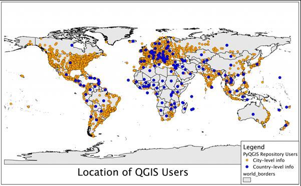
6 Estimated at least 100,000 Globally as of December 2011 Analysis performed by Gary Sherman by geocoding the I.P. addresses where QGIS was downloaded
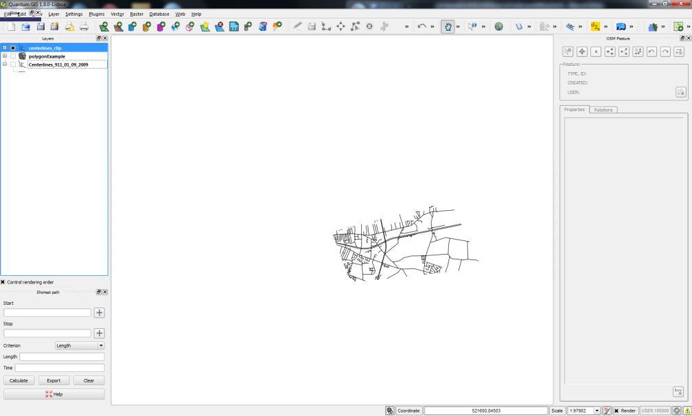
7
8 The request for at least familiarity with open source GIS is growing as a desired skill on many GIS job listings A survey by Eric Pimpler of GeoChalkboard last year on GIS jobs found that 14% of respondents listed open source GIS software as at least a secondary software used in their jobs
9
10 Free Variety of Geospatial tools for working with both raster and vector files Viable alternative to paid GIS software for most applications Catalyst for advances in paid GIS software industry Implemented Open Database Connectivity (ODBC) Esri followed suit.
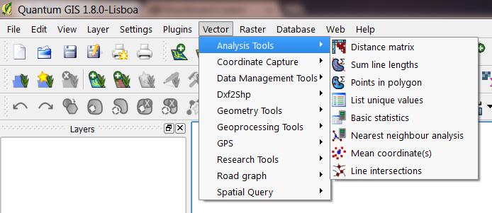
11 Bug Reporter on the Wiki Easy to use website on their hub.qgis.org page to report problems with quantum Support via forum Overnight Build for fixes to problems Open Street Map (OSM) Downloads Plays well with Esri GIS software Esri Shapefiles Personal Geodatabases (Not File Geodatabases)
12 Free You get what you pay for Limited published reference material No quick start guide Support via forum No Tech support to call Not for the un-initiated You have to know and understand basic GIS operational concepts to function well in Quantum You should be a tinkerer
13 Geospatial Data Abstraction Library (GDAL) MapServer PostGIS SPIT GRASS
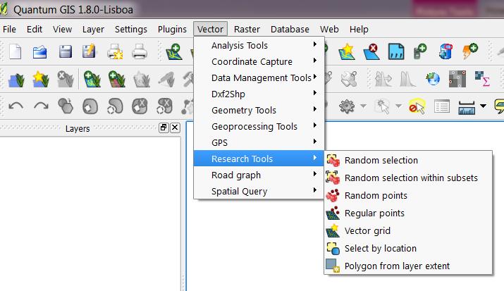
14 Core and External C++ or Python Data Provider Plugins Spatial Query Open Street Map (OSM) Web Mapping Services
15 Quantum offers a variety of Geospatial tools for working with both Vector and Raster Data


16 Multiple Tools for working with Vector Layers

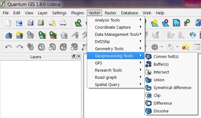
17

18 Import Vector files into Layers

19 At the end of the process the intersection points will show on layer


20 Can perform Split, Merge, Joins and Define Coordinates

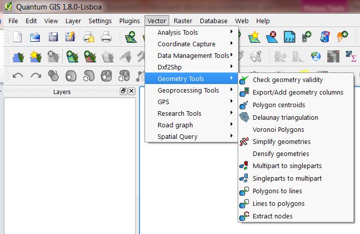
21 Multiple Tools for processing Geometry

22 Random Points in Layer

23 After Processing Triangulation Polygons Used for Modeling purposes and determining Density or Intensity of point sampling

24 Multiple Tools for Geoprocessing

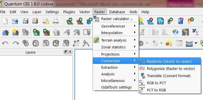
25 Select area to be Clipped using polygon overlay
26 After processing
27

28 Input Boundary Layer

29 After processing Can choose number of points Can stratify the sampling design by density and field value

30 Input Layer

31 Random Selection of 10 percent of features Selection by desired number of features or desired percentage of primary layer features

32 Multiple Tools for working with Raster Layers
33
34 Polygonize (Raster to Vector)

35 Polygonize After Processing
36 Contour Input Raster

37 Contour After Processing

38 Where: Salisbury University, Salisbury, Maryland When: Details are being put together Expect classes in June.
39 What: One week training Introduction to QGIS (2 days) Python scripting in pyqgis (2 days) Enterprise GIS with Open Source Software (1 day) Point of Contact: Dr. Arthur J Lembo AJLEMBO@salisbury.edu
40 Explanation of Interface Working with Data Connecting to Postgres QPy Concurrent multiple user editing
41 Richland, South Carolina In 1997 Lindau Chemical experienced an explosion in its Columbia plant Although no chemicals were released it raised concerns regarding the possible effects of ammonia release from this plant among the city leaders and local populace. We want to determine how many schools could be impacted and how many people would need to be evacuated if a ammonia release occurred at this plant.

42 Any Questions? Thank you for attending this workshop!
Karsten Vennemann, Seattle. QGIS Workshop CUGOS Spring Fling 2015
 Karsten Vennemann, Seattle 2015 a very capable and flexible Desktop GIS QGIS QGIS Karsten Workshop Vennemann, Seattle slide 2 of 13 QGIS - Desktop GIS originally a GIS viewing environment QGIS for the
Leveraging Your Geo-spatial Data Investments with Quantum GIS: an Open Source Geographic Information System
 Leveraging Your Geo-spatial Data Investments with Quantum GIS: an Open Source Geographic Information System Donald L. Schrupp Colorado Division of Wildlife (Retired) Danny Lewis Texas Parks and Wildlife
Among various open-source GIS programs, QGIS can be the best suitable option which can be used across partners for reasons outlined below.
 Comparison of Geographic Information Systems (GIS) software As of January 2018, WHO has reached an agreement with ESRI (an international supplier of GIS software) for an unlimited use of ArcGIS Desktop
How do I do that in Quantum GIS: illustrating classic GIS tasks Edited by: Arthur J. Lembo, Jr.; Salisbury University
 How do I do that in Quantum GIS: illustrating classic GIS tasks Edited by: Arthur J. Lembo, Jr.; Salisbury University How do I do that in Quantum GIS Page 1 Introduction from the editor:... 4 Database
Development of Univ. of San Agustin Geographic Information System (USAGIS)
") , pp.170-176 http://dx.doi.org/10.14257/astl.2014.48.27 Development of Univ. of San Agustin Geographic Information System (USAGIS) Rosslin John H. Robles Chair, Computer Science Department, University
, pp.170-176 http://dx.doi.org/10.14257/astl.2014.48.27 Development of Univ. of San Agustin Geographic Information System (USAGIS) Rosslin John H. Robles Chair, Computer Science Department, University
ArcGIS Pro: Essential Workflows STUDENT EDITION
 ArcGIS Pro: Essential Workflows STUDENT EDITION Copyright 2018 Esri All rights reserved. Course version 6.0. Version release date August 2018. Printed in the United States of America. The information contained
YYT-C3002 Application Programming in Engineering GIS I. Anas Altartouri Otaniemi
 YYT-C3002 Application Programming in Engineering GIS I Otaniemi Overview: GIS lectures & exercise We will deal with GIS application development in two lectures. Because of the versatility of GIS data models
Overview of Geospatial Open Source Software which is Robust, Feature Rich and Standards Compliant
 Overview of Geospatial Open Source Software which is Robust, Feature Rich and Standards Compliant Cameron SHORTER, Australia Key words: Open Source Geospatial Foundation, OSGeo, Open Standards, Open Geospatial
GIS CONCEPTS ARCGIS METHODS AND. 3 rd Edition, July David M. Theobald, Ph.D. Warner College of Natural Resources Colorado State University
 GIS CONCEPTS AND ARCGIS METHODS 3 rd Edition, July 2007 David M. Theobald, Ph.D. Warner College of Natural Resources Colorado State University Copyright Copyright 2007 by David M. Theobald. All rights
DATA SCIENCE SIMPLIFIED USING ARCGIS API FOR PYTHON
 DATA SCIENCE SIMPLIFIED USING ARCGIS API FOR PYTHON LEAD CONSULTANT, INFOSYS LIMITED SEZ Survey No. 41 (pt) 50 (pt), Singapore Township PO, Ghatkesar Mandal, Hyderabad, Telengana 500088 Word Limit of the
PostGIS Cookbook. open source I community experience distilled
 PostGIS Cookbook Over 80 task-based recipes to store, organize, manipulate, and analyze spatial data in a PostGIS database Paolo Corti Thomas J Kraft Stephen Vincent Mather Bborie Park PUBLISHING open
Data Aggregation with InfraWorks and ArcGIS for Visualization, Analysis, and Planning
 Data Aggregation with InfraWorks and ArcGIS for Visualization, Analysis, and Planning Stephen Brockwell President, Brockwell IT Consulting, Inc. Join the conversation #AU2017 KEYWORD Class Summary Silos
Existing Open Source Tools and Possibilities for Cadastre Systems
 Existing Open Source Tools and Possibilities for Cadastre Systems Gertrude Pieper Espada FIG Congress Sydney, 11-16 April 2010 What is FLOSS? What is open source? What open source software tools are available?
NR402 GIS Applications in Natural Resources
 NR402 GIS Applications in Natural Resources Lesson 1 Introduction to GIS Eva Strand, University of Idaho Map of the Pacific Northwest from http://www.or.blm.gov/gis/ Welcome to NR402 GIS Applications in
Arcgis Enterprise Performance And Scalability Best Practices
 Arcgis Enterprise Performance And Scalability Best Practices We have made it easy for you to find a PDF Ebooks without any digging. And by having access to our ebooks online or by storing it on your computer,
Newcastle City Council - Migration to QGIS and Open Source GIS
 Newcastle City Council - Migration to QGIS and Open Source GIS Brian Williams & Saber Razmjooei 13 April 2016 Outline I Why Open Source? Rational What we did How we did it Benefits Discussion Points QGIS
These modules are covered with a brief information and practical in ArcGIS Software and open source software also like QGIS, ILWIS.
 Online GIS Training and training modules covered are: 1. ArcGIS, Analysis, Fundamentals and Implementation 2. ArcGIS Web Data Sharing 3. ArcGIS for Desktop 4. ArcGIS for Server These modules are covered
Development and operation of GIS exercise materials for undergraduate students
 Development and operation of GIS exercise materials for undergraduate students Since around 2000, GIS researchers in Japan have collaborated to provide materials for GIS lecture classes for university
No. of Days. Building 3D cities Using Esri City Engine ,859. Creating & Analyzing Surfaces Using ArcGIS Spatial Analyst 1 7 3,139
 Q3 What s New? Creating and Editing Data with ArcGIS Pro Editing and Maintaining Parcels Using ArcGIS Spatial Analysis Using ArcGIS Pro User Workflows for ArcGIS Online Organizations Q3-2018 ArcGIS Desktop
The File Geodatabase API. Craig Gillgrass Lance Shipman
 The File Geodatabase API Craig Gillgrass Lance Shipman Schedule Cell phones and pagers Please complete the session survey we take your feedback very seriously! Overview File Geodatabase API - Introduction
GIS Level 2. MIT GIS Services
 GIS Level 2 MIT GIS Services http://libraries.mit.edu/gis Email: gishelp@mit.edu TOOLS IN THIS WORKSHOP - Definition Queries - Create a new field in the attribute table - Field Calculator - Add XY Data
Application of WebGIS and VGI for Community Based Resources Inventory. Jihn-Fa Jan Department of Land Economics National Chengchi University
 Application of WebGIS and VGI for Community Based Resources Inventory Jihn-Fa Jan Department of Land Economics National Chengchi University OUTLINE Introduction Methodology Results Conclusions 2 MOTIVATION
Free and Open Source Software for Cadastre and Land Registration : A Hidden Treasure? Gertrude Pieper Espada. Overview
 Free and Open Source Software for Cadastre and Land Registration : A Hidden Treasure? Gertrude Pieper Espada Overview FLOSS concepts Digital Land Administration systems FLOSS Database alternatives FLOSS
Spatial Data Analysis with ArcGIS Desktop: From Basic to Advance
 Spatial Data Analysis with ArcGIS Desktop: From Basic to Advance 1. Course overview Modern environmental, energy as well as resource modeling and planning require huge amount of geographically located
Digital Map of Mexico Platform and MxSIG. March 2017
 Digital Map of Mexico Platform and MxSIG March 2017 1 I. Digital Map of Mexico Platform Concept Evolution II. Digital Map of Mexico online Concept Capabilities Information available Other state units information
UNIT 4: USING ArcGIS. Instructor: Emmanuel K. Appiah-Adjei (PhD) Department of Geological Engineering KNUST, Kumasi
 Department of Geological Engineering KNUST, Kumasi") UNIT 4: USING ArcGIS Instructor: Emmanuel K. Appiah-Adjei (PhD) Department of Geological Engineering KNUST, Kumasi Getting to Know ArcGIS ArcGIS is an integrated collection of GIS software products ArcGIS
UNIT 4: USING ArcGIS Instructor: Emmanuel K. Appiah-Adjei (PhD) Department of Geological Engineering KNUST, Kumasi Getting to Know ArcGIS ArcGIS is an integrated collection of GIS software products ArcGIS
Administering your Enterprise Geodatabase using Python. Jill Penney
 Administering your Enterprise Geodatabase using Python Jill Penney Assumptions Basic knowledge of python Basic knowledge enterprise geodatabases and workflows You want code Please turn off or silence cell
GIS Workshop Data Collection Techniques
 GIS Workshop Data Collection Techniques NOFNEC Conference 2016 Presented by: Matawa First Nations Management Jennifer Duncan and Charlene Wagenaar, Geomatics Technicians, Four Rivers Department QA #: FRG
No. of Days. ArcGIS 3: Performing Analysis ,431. Building 3D cities Using Esri City Engine ,859
 What s New? Creating Story Maps with ArcGIS Field Data Collection and Management Using ArcGIS Get Started with Insights for ArcGIS Introduction to GIS Using ArcGIS & ArcGIS Pro: Essential Workflow Migrating
No. of Days. ArcGIS Pro for GIS Professionals ,431. Building 3D cities Using Esri City Engine ,859
 What s New? Creating Story Maps with ArcGIS Field Data Collection and Management Using ArcGIS Get Started with Insights for ArcGIS Introduction to GIS Using ArcGIS & ArcGIS Pro: Essential Workflow Migrating
Free Open Source Software for Geoinformatics (FOSS4G) A Practical Example System for Automated Geoscientific Analyses (SAGA)
 A Practical Example System for Automated Geoscientific Analyses (SAGA)") Free Open Source Software for Geoinformatics (FOSS4G) A Practical Example System for Automated Geoscientific Analyses (SAGA) Zlatko Horvat, MSc DGU Područni ured za katastar Čakovec My Motivation Give
Free Open Source Software for Geoinformatics (FOSS4G) A Practical Example System for Automated Geoscientific Analyses (SAGA) Zlatko Horvat, MSc DGU Područni ured za katastar Čakovec My Motivation Give
Popular Mechanics, 1954
 Introduction to GIS Popular Mechanics, 1954 1986 $2,599 1 MB of RAM 2017, $750, 128 GB memory, 2 GB of RAM Computing power has increased exponentially over the past 30 years, Allowing the existence of
JOB DESCRI PTI ON. GIS Administrator
 JOB DESCRI PTI ON JOB GRADE: GS-0 Cla ss Code : Office - 8 8 0 DEPARTMENT: 2 0 - FLSA: EXEMPT JOB NO: 6-0 9-2 7 SALARY: To Be De t e rm in e d Job description statements are intended to describe the general
Integrating Open Source GIS Software in Undergraduate Curriculum, Research, and Outreach - Recent Experiences at Salisbury University
 Free and Open Source Software for Geospatial (FOSS4G) Conference Proceedings Volume 15 Seoul, South Korea Article 38 2015 Integrating Open Source GIS Software in Undergraduate Curriculum, Research, and
GIS CONCEPTS ARCGIS METHODS AND. 2 nd Edition, July David M. Theobald, Ph.D. Natural Resource Ecology Laboratory Colorado State University
 GIS CONCEPTS AND ARCGIS METHODS 2 nd Edition, July 2005 David M. Theobald, Ph.D. Natural Resource Ecology Laboratory Colorado State University Copyright Copyright 2005 by David M. Theobald. All rights
QGIS FLO-2D Integration
 EPiC Series in Engineering Volume 3, 2018, Pages 1575 1583 Engineering HIC 2018. 13th International Conference on Hydroinformatics Karen O Brien, BSc. 1, Noemi Gonzalez-Ramirez, Ph. D. 1 and Fernando Nardi,
Geodatabase Management Pathway
 Geodatabase Management Pathway Table of Contents ArcGIS Desktop II: Tools and Functionality 3 ArcGIS Desktop III: GIS Workflows and Analysis 6 Building Geodatabases 8 Data Management in the Multiuser Geodatabase
Why GIS & Why Internet GIS?
 Why GIS & Why Internet GIS? The Internet bandwagon Internet mapping (e.g., MapQuest) Location-based services Real-time navigation (e.g., traffic) Real-time service dispatch Business Intelligence Spatial
ArcGIS Enterprise: What s New. Philip Heede Shannon Kalisky Melanie Summers Shreyas Shinde
 ArcGIS Enterprise: What s New Philip Heede Shannon Kalisky Melanie Summers Shreyas Shinde ArcGIS Enterprise is the new name for ArcGIS for Server ArcGIS Enterprise Software Components ArcGIS Server Portal
ArcGIS Runtime: Migrating from ArcGIS Engine. Rex Hansen
 ArcGIS Runtime: Migrating from ArcGIS Engine Rex Hansen Thank You to Our Sponsors Migrating from ArcGIS Engine to ArcGIS Runtime ArcGIS Runtime API: new and evolved workflows on all platforms Windows Linux
Enabling Success in Enterprise Asset Management: Case Study for Developing and Integrating GIS with CMMS for a Large WWTP
 Enabling Success in Enterprise Asset Management: Case Study for Developing and Integrating GIS with CMMS for a Large WWTP Allison Blake, P.E. 1*, Matthew Jalbert, P.E. 2, Julia J. Hunt, P.E. 2, Mazen Kawasmi,
ESRI Survey Summit August Clint Brown Director of ESRI Software Products
 ESRI Survey Summit August 2006 Clint Brown Director of ESRI Software Products Cadastral Fabric How does Cadastral fit with Survey? Surveyors process raw field observations Survey measurements define high-order
94-802Z: Geographic Information Systems Summer 2018
 94-802Z: Geographic Information Systems Summer 2018 Instructor: Professor Kristen Kurland Teaching Assistant(s): (Office hours to be posted on Canvas) TBA Class Web Site: http:/www.cmu.edu/canvas
GIS ADMINISTRATOR / WEB DEVELOPER EVANSVILLE-VANDERBURGH COUNTY AREA PLAN COMMISSION
 GIS ADMINISTRATOR / WEB DEVELOPER EVANSVILLE-VANDERBURGH COUNTY AREA PLAN COMMISSION SALARY RANGE INITIATION $43,277 SIX MONTHS $45,367 POSITION GRADE PAT VI The Evansville-Vanderburgh County Area Plan
Introduction to ArcGIS Server - Creating and Using GIS Services. Mark Ho Instructor Washington, DC
 Introduction to ArcGIS Server - Creating and Using GIS Services Mark Ho Instructor Washington, DC Technical Workshop Road Map Product overview Building server applications GIS services Developer Help resources
GIS-T 2010 Building a Successful Geospatial Data Sharing Framework: A Ohio DOT Success Story
 GIS-T 2010 Building a Successful Geospatial Data Sharing Framework: A Ohio DOT Success Story ODOT District 2 GIS John Puente District 1 GIS Coordinator\ Planning Administrator 2 Interoperability 3 District
GIS for Surveyors: Wetland Studies and Solutions, Inc.
 GIS for Surveyors: Concepts, Solutions, and Applications ` New Jersey Society of Professional Land Surveyors (NJSPLS) SurvCon 2013, Atlantic City, New Jersey Presented by John Cooke and Yeoanny A. Venetsanos,
gvsig a real tool for GIS technicians
 gvsig a real tool for GIS technicians Jorge Gaspar Sanz Salinas jsanz@prodevelop.es International Geodetic Students Meeting 05/05/08 Valencia Agenda of the project OK, but what can gvsig do for me now?
GIS Boot Camp for Education June th, 2011 Day 1. Instructor: Sabah Jabbouri Phone: (253) x 4854 Office: TC 136
 x 4854 Office: TC 136") GIS Boot Camp for Education June 27-30 th, 2011 Day 1 Instructor: Sabah Jabbouri Phone: (253) 833-9111 x 4854 Office: TC 136 Email: sjabbouri@greenriver.edu http://www.instruction.greenriver.edu/gis/ Summer
GIS Boot Camp for Education June 27-30 th, 2011 Day 1 Instructor: Sabah Jabbouri Phone: (253) 833-9111 x 4854 Office: TC 136 Email: sjabbouri@greenriver.edu http://www.instruction.greenriver.edu/gis/ Summer
DP Project Development Pvt. Ltd.
 Dear Sir/Madam, Greetings!!! Thanks for contacting DP Project Development for your training requirement. DP Project Development is leading professional training provider in GIS technologies and GIS application
GIS Resources for Local Governments
 ISSUE PAPER SERIES GIS Resources for Local Governments February 2018 NEW YORK STATE TUG HILL COMMISSION DULLES STATE OFFICE BUILDING 317 WASHINGTON STREET WATERTOWN, NY 13601 (315) 785-2380 WWW.TUGHILL.ORG
ArcGIS Enterprise: What s New. Philip Heede Shannon Kalisky Melanie Summers Sam Williamson
 ArcGIS Enterprise: What s New Philip Heede Shannon Kalisky Melanie Summers Sam Williamson ArcGIS Enterprise is the new name for ArcGIS for Server What is ArcGIS Enterprise ArcGIS Enterprise is powerful
Make it Spatial. Josh Tanner. Theresa Burcsu. Tools, techniques, and tips for incorporating GIS into your research
 Make it Spatial Tools, techniques, and tips for incorporating GIS into your research Theresa Burcsu Josh Tanner Oregon GIS Framework Coordinator GIS Analyst & Web Administrator Geospatial Enterprise Office
Geospatial Products V8i (SELECTseries 1)
") Geospatial Products V8i (SELECTseries 1) Keith Raymond Product Manager Geospatial Desktop Products Presentation Overview What are the various products? Why would you need them? Demonstrations 2 WWW.BENTLEY.COM
Geospatial Products V8i (SELECTseries 1) Keith Raymond Product Manager Geospatial Desktop Products Presentation Overview What are the various products? Why would you need them? Demonstrations 2 WWW.BENTLEY.COM
Bentley Map Advancing GIS for the World s Infrastructure
 Bentley Map Advancing GIS for the World s Infrastructure Presentation Overview Why would you need Bentley Map? What is Bentley Map? Where is Bentley Map Used? Why would you need Bentley Map? Because your
Open Access Geospatial Data
 Open Access Geospatial Data Tuesday, Oct. 25, 2016 Hannah Hamalainen Geospatial & Earth Sciences Librarian Geospatial Services Center Using Open Access Data to Make Maps is Easy Open source Geospatial
Valdosta State University Strategic Research & Analysis
 Christopher Neasbitt, Programmer Analyst Associate (cjneasbi@valdosta.edu) Kristina M. Cragg, Ph.D., Assistant to the President for Strategic Research & Analysis (kmcragg@valdosta.edu) Amir Atabekov, Student
Institutional Research with Public Data and Open Source Software
 2017 Institutional Research with Public Data and Open Source Software DUE1304591, 1644409, 1700496 Opinions expressed are those of the authors and not necessarily those of the National Science Foundation.
FREE GIS PLUS DATABASE SYSTEM FOR DISSEMINATION ACTIVITY OF EARTHQUAKE DISASTER MITIGATION
 FREE GIS PLUS DATABASE SYSTEM FOR DISSEMINATION ACTIVITY OF EARTHQUAKE DISASTER MITIGATION T. Yokoi 1, J. Subedi 2, R. Rajbhandari 3, M. B. Prajapati 4, T. Mori 5, A. Takubo 6, M. Niwa 7 ABSTRACT : 1 Senior
Georelational Vector Data Model
 Georelational Vector Data Model Contents Georelational Data Model Representation of Simple Features Topology Non-topological Vector Data Data Models for Composite Features Geo-relational Looking at a paper
Spatial Analysis with ArcGIS Pro STUDENT EDITION
 Spatial Analysis with ArcGIS Pro STUDENT EDITION Copyright 2018 Esri All rights reserved. Course version 2.0. Version release date November 2018. Printed in the United States of America. The information
Datahoods or Data-Driven Neighborhoods. Using GIS to better understand neighborhoods
 Datahoods or Data-Driven Neighborhoods Using GIS to better understand neighborhoods Who am I? Silas Toms President, Loki Intelligent Corporation Author, ArcPy and ArcGIS (2 editions) Co-Host of the Mappyist
OSGIS Platform. Storing and distributing PostGIS, Deegree, UMN Map Server Desktop visualization JUMP, QGIS, Thuban, udig, gvsig
 GIS groups of tasks Geodata collecting, updating Geodata storing and distributing Geodata analysis Geodata visualization: Desktop, Internet, Printing Geodata describing: metadata management Geodata converting:
OPEN SOURCE TECHNOLOGIES IN GEOGRAPHIC INFORMATION SYSTEMS
 GEOGRAPHIC INFORMATION SYSTEMS OPEN SOURCE TECHNOLOGIES IN GEOGRAPHIC INFORMATION SYSTEMS Marijana Petković 1, Vladmir Bulatović 1, Ivan Aleksić 2 1 University of Novi Sad, Faculty of Technical Sciences,
Welcome to NR502 GIS Applications in Natural Resources. You can take this course for 1 or 2 credits. There is also an option for 3 credits.
 Welcome to NR502 GIS Applications in Natural Resources. You can take this course for 1 or 2 credits. There is also an option for 3 credits. The 1st credit consists of a series of readings, demonstration,
ArcGIS Runtime: Migrating Your Apps from ArcGIS Engine. Eric Bader Lucas Danzinger Mike Branscomb
 ArcGIS Runtime: Migrating Your Apps from ArcGIS Engine Eric Bader Lucas Danzinger Mike Branscomb Migrating to ArcGIS Runtime ArcGIS Engine ArcGIS Runtime AppStudio for ArcGIS Apps: Collector, Workforce,
INTRODUCTION TO GIS. Dr. Ori Gudes
 INTRODUCTION TO GIS Dr. Ori Gudes Outline of the Presentation What is GIS? What s the rational for using GIS, and how GIS can be used to solve problems? Explore a GIS map and get information about map
Esri UC2013. Technical Workshop.
 Esri International User Conference San Diego, California Technical Workshops July 9, 2013 CAD: Introduction to using CAD Data in ArcGIS Jeff Reinhart & Phil Sanchez Agenda Overview of ArcGIS CAD Support
Environmental Systems Research Institute
 Introduction to ArcGIS ESRI Environmental Systems Research Institute Redlands, California 2 ESRI GIS Development Arc/Info (coverage model) Versions 1-7 from 1980 1999 Arc Macro Language (AML) ArcView (shapefile
Geodatabase: Best Practices. Robert LeClair, Senior Instructor
 Geodatabase: Best Practices Robert LeClair, Senior Instructor Agenda Geodatabase Creation Data Ownership Data Model Data Configuration Geodatabase Behaviors Data Validation Extending Performance Geodatabase
A Distributed GIS Architecture for Research in Baalbek Based on CISAR
 234 Frank Henze A Distributed GIS Architecture for Research in Baalbek Based on CISAR Abstract: Research underway in Baalbek extends from the immediate vicinity of the excavation areas to the monumental
Web-GIS based Framework for Solid Waste Complaint Management for Sustainable and Smart City
 Cloud Publications International Journal of Advanced Remote Sensing and GIS 2016, Volume 5, Issue 10, pp. 1930-1936 ISSN 2320-0243, DOI: 10.23953/cloud.ijarsg.71 Research Article Open Access Web-GIS based
Instituto de Pesquisas Meteorológicas - IPMet Universidade Estadual Paulista - Unesp
 IPMET WEB GIS APPLICATION FOR SEVERE WEATHER ALERT AND DECISION SUPPORT Jaqueline Murakami Kokitsu Instituto de Pesquisas Meteorológicas - IPMet Universidade Estadual Paulista - Unesp IPMet/Unesp Meteorological
ArcGIS for Desktop. ArcGIS for Desktop is the primary authoring tool for the ArcGIS platform.
 ArcGIS for Desktop ArcGIS for Desktop ArcGIS for Desktop is the primary authoring tool for the ArcGIS platform. Beyond showing your data as points on a map, ArcGIS for Desktop gives you the power to manage
A Model of GIS Interoperability Based on JavaRMI
 A Model of GIS Interoperability Based on Java Gao Gang-yi 1 Chen Hai-bo 2 1 Zhejiang University of Finance & Economics, Hangzhou 310018, China 2 College of Computer Science and Technology, Zhejiang UniversityHangzhou
ArcGIS Pro Q&A Session. NWGIS Conference, October 11, 2017 With John Sharrard, Esri GIS Solutions Engineer
 ArcGIS Pro Q&A Session NWGIS Conference, October 11, 2017 With John Sharrard, Esri GIS Solutions Engineer jsharrard@esri.com ArcGIS Desktop The applications ArcGIS Pro ArcMap ArcCatalog ArcScene ArcGlobe
December 2009 ArcGIS Server Functionality Matrix
 December 2009 ArcGIS Server 9.3.1 Functionality Matrix ESRI 380 New York St., Redlands, CA 92373-8100 USA TEL 909-793-2853 FAX 909-793-5953 E-MAIL info@esri.com WEB www.esri.com Copyright 2009 ESRI All
ArcGIS Earth an Intro
 ArcGIS Earth an Intro Chris Andrews Product Manager, 3D and ArcGIS Earth Brian Sims 3D Content Lead 3D across the Esri product family ArcGIS Pro 3D Analyst CityEngine ArcGIS for Server ArcGIS Online ArcGIS
All About Spatial Data. Find it, Manage it, Use it
 All About Spatial Data Find it, Manage it, Use it Workshop Outline Define spatial data Spatial data formats Data Sources Metadata Evaluating Spatial Data Data Management Activities: define spatial data,
GeoPackage, das Shapefile der Zukunft
 FOSSGIS 2016 GeoPackage, das Shapefile der Zukunft @PirminKalberer Sourcepole AG, Zürich www.sourcepole.ch About Sourcepole > QGIS > 4 C++ core devs > Project Steering Commitee > QGIS Server, Printing,
GIS PORTFOLIO MOHAMED MAGDY MOHAMED HUSSAIN GIS ENGINEER. UWF GIS ONLINE CERTIFICATE GIS Internship (GIS4944)
") 2012 GIS PORTFOLIO MOHAMED MAGDY MOHAMED HUSSAIN GIS ENGINEER UWF GIS ONLINE CERTIFICATE GIS Internship (GIS4944) Portfolio Table of Contents Subject... Page Personal statement/mission/philosophy... 1
2012 GIS PORTFOLIO MOHAMED MAGDY MOHAMED HUSSAIN GIS ENGINEER UWF GIS ONLINE CERTIFICATE GIS Internship (GIS4944) Portfolio Table of Contents Subject... Page Personal statement/mission/philosophy... 1
When Map Quality Matters
 When Map Quality Matters 50% 25% Powerful geospatial mapping tools for Adobe Creative Cloud and offline map solutions for mobile devices 20% When Map Quality Matters 10% We re focused on creating powerful
GIS for Business Intelligence: Getting Cloud Connected
 GIS for Business Intelligence: Getting Cloud Connected Ed Farrell Director of GIS Solutions, DVG efarrell@dvginteractive.com http://dvginteractive.com October 19 th, 2017 Lake Placid Convention Center
Cobb County GIS: Beyond the Map
 Cobb County GIS: Beyond the Map Charles Fail Tim Scharff Cobb County GIS SERUG 2008 1 Topics Cobb GIS Overview The Early Years Enterprise GIS Transition Putting It Together Looking Ahead SERUG 2008 2 Cobb
Using the File Geodatabase API. Lance Shipman David Sousa
 Using the File Geodatabase API Lance Shipman David Sousa Overview File Geodatabase API - Introduction - Supported Tasks - API Overview - What s not supported - Updates - Demo File Geodatabase API Provide
GeoPostcodes. Trinidad & Tobago
 Trinidad & Tobago Trinidad & Tobago About.com Launched in 2007, website offers comprehensive and reliable databases of localities, streets, administrative regions, ZIP/postal codes and lots of other information
Introduction to the 176A labs and ArcGIS Purpose of the labs
 Introduction to the 176A labs and ArcGIS Purpose of the labs Acknowledgement: Slides by David Maidment, U Texas-Austin and Francisco Olivera (TAMU) Hands-on experience with a leading software package Introduction
IMPLEMENTING GOVERNMENT-WIDE ENTERPRISE GIS; THE FEDERATED MODEL
 IMPLEMENTING GOVERNMENT-WIDE ENTERPRISE GIS; THE FEDERATED MODEL James E. Mitchell, Ph. D. IT GIS Manager Louisiana Department of Transportation and Development presented at the ESRI International Users
The Northwest Environmental Training Center presents:
 The Northwest Environmental Training Center presents: Introduction to ArcGIS 9 for Fisheries and Wildlife Biology Applications Course ID: GIS - 400 October 1-3, 2008, 8:30 A.M. to 5 P.M. **Venue Change**
GIS for the Beginner on a Budget
 GIS for the Beginner on a Budget Andre C. Bally, RLA, GIS Coordinator, Harris County Public Infrastructure Department Engineering Division This presentation, GIS for Beginners on a Budget. will briefly
Development of a server to manage a customised local version of OpenStreetMap in Ireland
 Development of a server to manage a customised local version of OpenStreetMap in Ireland BłaŜej Ciepłuch 1, Jianghua Zheng 1, Peter Mooney 1,2, Adam C. Winstanley 1 1 Department of Computer Science, National
Spatial Data Management of Bio Regional Assessments Phase 1 for Coal Seam Gas Challenges and Opportunities
 Spatial Data Management of Bio Regional Assessments Phase 1 for Coal Seam Gas Challenges and Opportunities By Dr Zaffar Sadiq Mohamed-Ghouse Principal Consultant, Spatial & IT, GHD zaffar.sadiq@ghd.com
Geospatial Preservation: State of the Landscape. A Quick Overview. Steve Morris NCSU Libraries
 Geospatial Preservation: State of the Landscape A Quick Overview Steve Morris NCSU Libraries SAA 2011 August 26, 2011 14 Brief Overview of the Problem 15 Variety of Geospatial Data Types Variety of producers
GIS FOR PLANNING. Course Overview. Schedule. Instructor. Prerequisites. Urban Planning 792 Thursday s 5:30-8:10pm SARUP 158
 GIS FOR PLANNING Urban Planning 792 Thursday s 5:30-8:10pm SARUP 158 Schedule Class/Lab - SARUP 158 Thursdays 5:30pm - 8:10pm Office Hours - By Appointment Project Ideas - Week 4 Final - 5/10/2018 Instructor
MapOSMatic: city maps for the masses
 MapOSMatic: city maps for the masses Thomas Petazzoni Libre Software Meeting July 9th, 2010 Outline 1 The story 2 MapOSMatic 3 Behind the web page 4 Pain points 5 Future work 6 Conclusion Thomas Petazzoni
ArcGIS. for Server. Understanding our World
 ArcGIS for Server Understanding our World ArcGIS for Server Create, Distribute, and Manage GIS Services You can use ArcGIS for Server to create services from your mapping and geographic information system
Open Source Software Education in Texas
 Open Source Software Education in Texas PHILLIP DAVIS / RICHARD SMITH GEOACADEMY The Challenge for Open Source Adoption OPEN SOURCE Less the 5% of US colleges and universities offer training in Free and