Open Source Software Education in Texas
|
|
|
- Myron Kelly
- 5 years ago
- Views:
Transcription
1 Open Source Software Education in Texas PHILLIP DAVIS / RICHARD SMITH GEOACADEMY
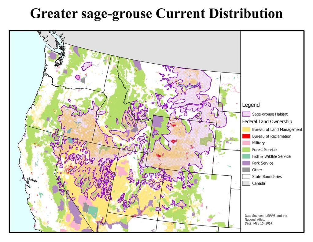
2 The Challenge for Open Source Adoption OPEN SOURCE Less the 5% of US colleges and universities offer training in Free and Open Source Geospatial Software (FOSS4G) Commercial FOSS4G training is far and few between and predominantly place-based F2F Lack of recognized Open Source industry certification PROPRIETARY One proprietary GIS vendor reports their software is used by 7,000 colleges and universities globally Commercial vendors have well-established training programs and certification pathways
3 The GeoAcademy Project Experiment Loose confederation of US-based GIS educators at colleges and universities. Curriculum development effort spanning 3 years resulting in an integrated collection of five introductory GIS courses featuring FOSS4G solutions for the lab component. Pedagogically based on the US Department of Labor s Geospatial Technology Competency Model (GTCM). Developed using funds from US National Science Foundation and Department of Labor grants. Materials offered for free reuse under the Creative Commons BY 3.0 license.
4 GeoAcademy Project Goals Expand the use of Open Source GIS software (FOSS4G) in college and universities to prepare our future geospatial technology industry workers with the broadest possible technical skills. Provide educators and trainers with foundational Open Education Resource (OER) materials to kick-start adoption of FOSS4G in schools, colleges and universities in the US and beyond. Expand the OSGeo/ICA/ISPRS Geo for All initiative and increase the number of colleges and universities in the research collaborative ( Demonstrate the successful use of GeoAcademy materials for online learning to provide widespread training opportunities to rural, remote and underserved populations around the globe. Build a self-sustaining community of practice among educators and trainers to build, curate, share and build a FOSS4G OER repository of curriculum materials, licensed under CC BY license on stable Github platform.
5 GeoAcademy Curriculum Consist of 5 Core Courses: GST 101 Introduction GIS GST 102 Spatial Analysis GST 103 Data Management GST 104 Cartography GST 105 Remote Sensing

6 GST 101 Introduction to Geospatial Technology Using QGIS Fundamental overview of GIS theory and practice Geospatial data models and file formats (vector, raster, etc.) Data editing Georeferencing Fundamentals of cartography Introduction to remote sensing Basic spatial analysis
7 Cartography
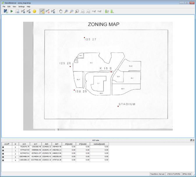
8 Georeferencing

9 Basic Analysis

10 GST 102 Spatial Analysis using QGIS Prepare data for use in analysis Problem solving using geospatial tools and methods Automating workflows Present the results of a using terminology and visualizations

11 Vector Overlay Techniques
12 Automating Workflows
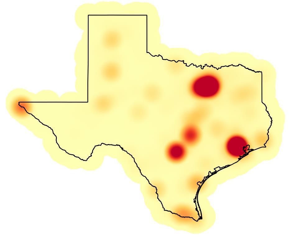

13 Heat Maps

14 Network Analysis GRASS Plugin

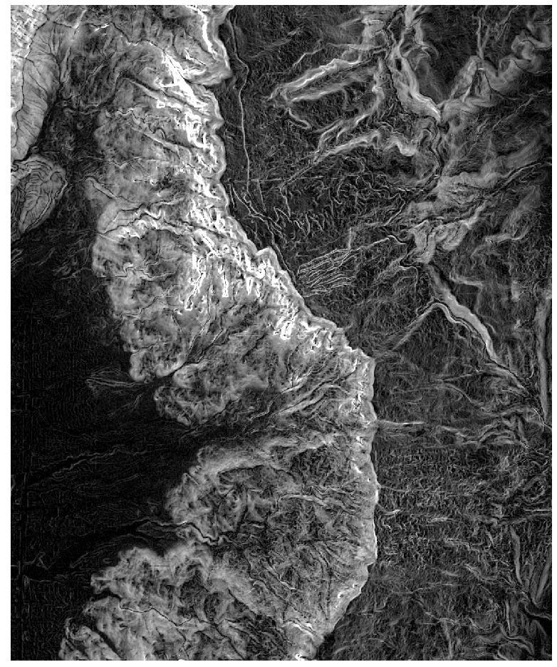
15 Terrain Analysis

16 GST 103 Data Acquisition and Management using QGIS Setting up a project databases Vector data structures Raster data structures Spatial data quality Data sources


17 Setting up a Project Database using SpatiaLite
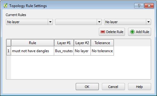
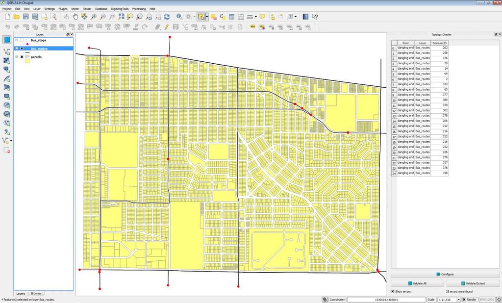
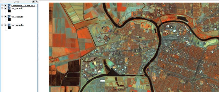
18 Topology

19 Spatial Data Quality & Metadata
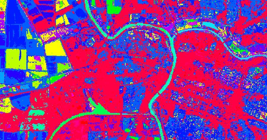
 Describe the components of a map (map elements) Employ an appropriate geographic referencing system (datum, projection, coordinate system) Select and apply ethical and appropriate data model, map")
20 GST 104 Introduction to Cartography using QGIS and Inkscape Categorize and describe different types of maps (thematic, reference, etc.) Describe the components of a map (map elements) Employ an appropriate geographic referencing system (datum, projection, coordinate system) Select and apply ethical and appropriate data model, map scale, map elements, symbolization and color Design professional quality maps employing cartographic principles Critique maps for appropriate use of cartographic design principles

21 Working with Coordinate Systems
22 Cartography
23 Cartography
 Select appropriate data set for remote sensing application based on spectral, temporal, radiometric and spatial resolution Describe characteristics of passive and active remote sensing systems")
24 GST Introduction to Remote Sensing using QGIS and GRASS GIS Basic concepts of remote sensing (i.e. Electromagnetic Spectrum, etc.) Select appropriate data set for remote sensing application based on spectral, temporal, radiometric and spatial resolution Describe characteristics of passive and active remote sensing systems (such as multispectral, LiDAR and Radar) Perform basic remote sensing workflows to solve problems (such as acquiring data, feature extraction, change detection, preand post-processing, create composite images and image classification) Interpret, analyze and summarize results of a remote sensing workflow
25 Band Combinations
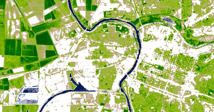
26 NDVI
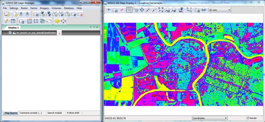
27 Supervised & Unsupervised Classification
28 The Results All five courses are published for reuse on our Github: and at More than 7,500 individuals have enrolled in one of our free course offering since June A dozen colleges have adopted the curriculum materials for use in their GIS programs for Our website has had more than 50,000 visits ( Partner colleges are now members of the GeoForAll initiative ( We have impacted educators, trainers, professionals, students and retirees in every continent on the globe including 3 rd world nations in Asia, Africa and South America.

29 GeoAcademy website activity since August 2014

30 GeoMOOC on Canvas Networks

31 Canvas GeoMOOC course offering March 2015

32 GeoMOOC Landing page (1 of 2)

33 GeoMOOC landing page (2 of 2)

34 GeoMOOC reaches 4500 enrollment
35 GeoMOOC Student Testimonials At Present I am living in Bangladesh. I am working in a International development organization as a Senior Monitoring officer-m&e. As a Monitoring personal this course will help me to mapping location with population. This Course also help me to conduct baseline survey along with different study. It would be helped me to reach my GIS skill and my future career. My name is Jacob, and I am located in Tennessee in the United States. I am taking this course because I am an archaeologist by trade, and GIS has become an integral part of our modern methodology, and, as such, I am always looking for more training and knowledge in the field. I already have some experience with ArcGIS, but I am a proponent of open source technology so I jumped at the chance to become more familiar with QGIS. I am currently assessing whether QGIS is suitable for teaching some of the introduction courses to GIS and remote sensing at my faculty. Besides that I am about to finish my MSc in Geoinformation Science and Earth Observations at University of Twente (The Netherlands).
36 4,500 total enrolled (March ) 1,100 completed first written assignment 500 completed first mapping exercise GeoMOOC Results Engagement and completion rate matches that of the recent Penn State / Esri / Coursera GeoINT MOOC (21,000 enrolled with 1,100 completers) Demonstrates the potential for online offerings of FOSS4G technical training and education
37 GeoAcademy: The Future Working with several vendors to semi-commercialize the GeoAcademy content in order to reach much broader audience and sustain the development of new and expanded materials. Pushing to gain further adoption of the QGIS curriculum through Open Education Resources organizations. Working with the GeoForAll initiative to push for much greater participation in Open Source software adoption by more colleges and universities worldwide, but especially in the US which lags well behind the EU and other regions. Wish to incorporate QGIS Project provided vendor certification into the curriculum to professionalize the material and provide income resource for QGIS Project efforts.


38 Contacts Phillip Davis Access to free Canvas courses: Richard Access to Curriculum Materials: /open-source-gis/
Building a New FOSS4G Technology Workforce PHILLIP DAVIS / KURT MENKE / RICHARD SMITH / JOHN VAN HOESEN THE GEOACADEMY TEAM
 Building a New FOSS4G Technology Workforce PHILLIP DAVIS / KURT MENKE / RICHARD SMITH / JOHN VAN HOESEN THE GEOACADEMY TEAM The Opportunity Global geospatial industry brings in $270 billion in annual revenue
WHAT YOU WILL LEARN TODAY
 WHAT YOU WILL LEARN TODAY Overview of the new GeoAcademy Curriculum Background on curriculum development Curriculum alignment with national standards Description of the five GIS courses Details of the
WHAT YOU WILL LEARN TODAY
 WHAT YOU WILL LEARN TODAY Overview of the new QGIS Academy Curriculum Background on curriculum development Curriculum alignment with national standards Description of the five GIS courses Details of the
Geospatial Science and Technology Model Courses and Certificate:
 Geospatial Science and Technology Model Courses and Certificate: Guidelines and Tools to Align Curriculum to Workforce Needs Ann Johnson Associate Director gisajohnson@delmar.edu Funded by National Science
1. Omit Human and Physical Geography electives (6 credits) 2. Add GEOG 677:Internet GIS (3 credits) 3. Add 3 credits to GEOG 797: Final Project
 2. Add GEOG 677:Internet GIS (3 credits) 3. Add 3 credits to GEOG 797: Final Project") The Department of Geography and the Office of Professional Studies propose to modify the Master of Professional Studies in Geospatial Information Sciences (GIS) as follows: 1. Omit Human and Physical Geography
The Department of Geography and the Office of Professional Studies propose to modify the Master of Professional Studies in Geospatial Information Sciences (GIS) as follows: 1. Omit Human and Physical Geography
Introduction to Coastal GIS
 Held on Tues, 1/8/13 through Thurs, 1/10/13 Location: Roger Williams University, Bristol, RI Audience: The intended audiences for this course are federal and state personnel, municipal staff and officials,
Software. People. Data. Network. What is GIS? Procedures. Hardware. Chapter 1
 People Software Data Network Procedures Hardware What is GIS? Chapter 1 Why use GIS? Mapping Measuring Monitoring Modeling Managing Five Ms of Applied GIS Chapter 2 Geography matters Quantitative analyses
Geographic Systems and Analysis
 Geographic Systems and Analysis New York University Robert F. Wagner Graduate School of Public Service Instructor Stephanie Rosoff Contact: stephanie.rosoff@nyu.edu Office hours: Mondays by appointment
USGIF Essential Body of Knowledge Competency Areas
 GEOINT Job/Practice Analysis USGIF, in consultation with psychometric consultants and the GEOINT community, executed a job/practice analysis to identify common competencies within the GEOINT profession.
FIRE DEPARMENT SANTA CLARA COUNTY
 DEFINITION FIRE DEPARMENT SANTA CLARA COUNTY GEOGRAPHIC INFORMATION SYSTEM (GIS) ANALYST Under the direction of the Information Technology Officer, the GIS Analyst provides geo-spatial strategic planning,
Increasing GI awareness in local authorities in Poland experiences from the INSPIRE Academy training programme
 Increasing GI awareness in local authorities in Poland experiences from the INSPIRE Academy training programme http://www.akademiainspire.pl Maria Andrzejewska, Monika Rusztecka UNEP/GRID-Warsaw Centre,
Geospatial Analysis in Cultural Anthropology
 Eduardo Brondizio (ebrondiz@ufl.edu) Tracy Van Holt (tvanholt@ufl.edu) Geospatial Analysis in Cultural Anthropology Description and Objectives: This intensive course introduces different components of
Building open source geospatial education at research universities: where we are and what is holding us back
 42 KEYNOTE TALKS Building open source geospatial education at research universities: where we are and what is holding us back Authors - Helena Mitasova, Department of Marine, Earth, and Atmospheric Sciences,
Rural GIS Applications Geospatial Technology Awareness
 Rural GIS Applications Geospatial Technology Awareness Mike Rudibaugh, Ph.D. Co-PI NSF GeoTech Center Geography/GIS Instructor Lake Land College mrudibau@lakeland.cc.il.us 217-234-5244 What is the GeoTech
Dr. Stephen J. Walsh Department of Geography, UNC-CH Fall, 2007 Monday 3:30-6:00 pm Saunders Hall Room 220. Introduction
 Geographic Information Systems Geography 491 Dr. Stephen J. Walsh Department of Geography, UNC-CH Fall, 2007 Monday 3:30-6:00 pm Saunders Hall Room 220 Introduction Organizations that have a planning,
CERTIFICATE PROGRAM IN
 CERTIFICATE PROGRAM IN GEOGRAPHIC INFORMATION SCIENCE Department of Geography University of Utah 260 S. Central Campus Dr., Rm 270 Salt Lake City, UT 84112-9155 801-581-8218 (voice); 801-581-8219 (fax)
INTEGRATING GEOSPATIAL PERSPECTIVES IN THE ANTHROPOLOGY CURRICULUM AT THE UNIVERSITY OF NEW MEXICO (UNM)
") INTEGRATING GEOSPATIAL PERSPECTIVES IN THE ANTHROPOLOGY CURRICULUM AT THE UNIVERSITY OF NEW MEXICO (UNM) VERONICA ARIAS HEATHER RICHARDS JUDITH VAN DER ELST DEPARTMENT OF ANTHROPOLOGY MARCH 2005 INTEGRATING
INTEGRATING GEOSPATIAL PERSPECTIVES IN THE ANTHROPOLOGY CURRICULUM AT THE UNIVERSITY OF NEW MEXICO (UNM) VERONICA ARIAS HEATHER RICHARDS JUDITH VAN DER ELST DEPARTMENT OF ANTHROPOLOGY MARCH 2005 INTEGRATING
ArcGIS for Desktop. ArcGIS for Desktop is the primary authoring tool for the ArcGIS platform.
 ArcGIS for Desktop ArcGIS for Desktop ArcGIS for Desktop is the primary authoring tool for the ArcGIS platform. Beyond showing your data as points on a map, ArcGIS for Desktop gives you the power to manage
DP Project Development Pvt. Ltd.
 Dear Sir/Madam, Greetings!!! Thanks for contacting DP Project Development for your training requirement. DP Project Development is leading professional training provider in GIS technologies and GIS application
Experiences and Directions in National Portals"
 FIG Seminar on e-land Administration Innsbruck/Austria 2-4 June 2004 "ESRI's Experiences and Directions in National Portals" Kevin Daugherty Cadastral/Land Records Manager ESRI Topic Points Technology
GIS and Forest Engineering Applications FE 357 Lecture: 2 hours Lab: 2 hours 3 credits
 GIS and Forest Engineering Applications FE 357 Lecture: 2 hours Lab: 2 hours 3 credits Instructor: Michael Wing Assistant Professor Forest Engineering Department Oregon State University Peavy Hall 275
USING LANDSAT IN A GIS WORLD
 USING LANDSAT IN A GIS WORLD RACHEL MK HEADLEY; PHD, PMP STEM LIAISON, ACADEMIC AFFAIRS BLACK HILLS STATE UNIVERSITY This material is based upon work supported by the National Science Foundation under
Teaching GIS for Land Surveying
 Teaching GIS for Land Surveying Zhanjing (John) Yu Evergreen Valley College, San Jose, California James Crossfield California State University at Fresno, Fresno California 7/13/2006 1 Outline of the Presentation
Geospatial Intelligence
 Geospatial Intelligence Geospatial analysis has existed as long as humans have made and studied maps but its importance to the intelligence community has skyrocketed in the past several years, with Unmanned
Spatial Data Analysis with ArcGIS Desktop: From Basic to Advance
 Spatial Data Analysis with ArcGIS Desktop: From Basic to Advance 1. Course overview Modern environmental, energy as well as resource modeling and planning require huge amount of geographically located
Regional Centre for Mapping of Resources for Development (RCMRD), Nairobi, Kenya
, Nairobi, Kenya") Regional Centre for Mapping of Resources for Development (RCMRD), Nairobi, Kenya Introduction to GIS (2 weeks: 10 days) Intakes: 8 th January, 6 th February, 5th March, 3 rd. April 9 th, May 7 th, June
Regional Centre for Mapping of Resources for Development (RCMRD), Nairobi, Kenya Introduction to GIS (2 weeks: 10 days) Intakes: 8 th January, 6 th February, 5th March, 3 rd. April 9 th, May 7 th, June
The Changing Face of Geospatial Technology
 The Changing Face of Geospatial Technology Vincent A. DiNoto, Jr. Director of GeoTech Center Vince.dinoto@kctcs.edu Based upon work supported by the National Science Foundation under Grant DUE ATE 1304591.
The National Geospatial Technology Center of Excellence and a look at the future of Geospatial Technology
 The National Geospatial Technology Center of Excellence and a look at the future of Geospatial Technology Vincent A. DiNoto, Jr. Director of GeoTech Center Vince.dinoto@kctcs.edu Based upon work supported
GEOSPATIAL ENGINEER ALC
 FORT LEONARD WOOD, MO NONCOMMISIONED OFFICERS ACADEMY SYLLABUS FOR 12Y3O ADVANCED LEADER COURSE GEOSPATIAL ENGINEER ALC Purpose: The 12Y30 Geospatial Engineer Advanced Leader Course is designed to develop
Regional Centre for Mapping of Resources for Development (RCMRD), Nairobi, Kenya
, Nairobi, Kenya") Regional Centre for Mapping of Resources for Development (RCMRD), Nairobi, Kenya Introduction GIS ( 2 weeks: 10 days) Intakes: 7 th Jan, 4 th Feb,4 th March, 1 st April 6 th May, 3 rd June, 1 st July,
Regional Centre for Mapping of Resources for Development (RCMRD), Nairobi, Kenya Introduction GIS ( 2 weeks: 10 days) Intakes: 7 th Jan, 4 th Feb,4 th March, 1 st April 6 th May, 3 rd June, 1 st July,
Hydrologic Engineering Applications of Geographic Information Systems
 Hydrologic Engineering Applications of Geographic Information Systems Davis, California Objectives: The participant will acquire practical knowledge and skills in the application of GIS technologies for
GEOGRAPHICAL INFORMATION SYSTEMS. GIS Foundation Capacity Building Course. Introduction
 GEOGRAPHICAL INFORMATION SYSTEMS. GIS Foundation Capacity Building Course. Introduction In recent times digital mapping has become part and parcel of our daily lives with experience from Google Maps on
Innovation. The Push and Pull at ESRI. September Kevin Daugherty Cadastral/Land Records Industry Solutions Manager
 Innovation The Push and Pull at ESRI September 2004 Kevin Daugherty Cadastral/Land Records Industry Solutions Manager The Push and The Pull The Push is the information technology that drives research and
GIS PORTFOLIO MOHAMED MAGDY MOHAMED HUSSAIN GIS ENGINEER. UWF GIS ONLINE CERTIFICATE GIS Internship (GIS4944)
") 2012 GIS PORTFOLIO MOHAMED MAGDY MOHAMED HUSSAIN GIS ENGINEER UWF GIS ONLINE CERTIFICATE GIS Internship (GIS4944) Portfolio Table of Contents Subject... Page Personal statement/mission/philosophy... 1
2012 GIS PORTFOLIO MOHAMED MAGDY MOHAMED HUSSAIN GIS ENGINEER UWF GIS ONLINE CERTIFICATE GIS Internship (GIS4944) Portfolio Table of Contents Subject... Page Personal statement/mission/philosophy... 1
Introduction to Coastal GIS
 Introduction to Coastal GIS Event was held on Tues, 1/8/13 - Thurs, 1/10/13 Time: 9:00 am to 5:00 pm Location: Roger Williams University, Bristol, RI Audience: The intended audiences for this course are
GIS Visualization: A Library s Pursuit Towards Creative and Innovative Research
 GIS Visualization: A Library s Pursuit Towards Creative and Innovative Research Justin B. Sorensen J. Willard Marriott Library University of Utah justin.sorensen@utah.edu Abstract As emerging technologies
GTECH 380/722 Analytical and Computer Cartography Hunter College, CUNY Department of Geography
 GTECH 380/722 Analytical and Computer Cartography Hunter College, CUNY Department of Geography Fall 2014 Mondays 5:35PM to 9:15PM Instructor: Doug Williamson, PhD Email: Douglas.Williamson@hunter.cuny.edu
Regional Centre for Mapping of Resources for Development (RCMRD), Nairobi, Kenya. Introduction GIS ( 2 weeks: 10 days)
, Nairobi, Kenya. Introduction GIS ( 2 weeks: 10 days)") Regional Centre for Mapping of Resources for Development (RCMRD), Nairobi, Kenya Introduction GIS ( 2 weeks: 10 days) Intakes: 8 th Jan, 6 th Feb,5 th March, 3 rd April 9 th, May 7 th, June 4 th, July
Regional Centre for Mapping of Resources for Development (RCMRD), Nairobi, Kenya Introduction GIS ( 2 weeks: 10 days) Intakes: 8 th Jan, 6 th Feb,5 th March, 3 rd April 9 th, May 7 th, June 4 th, July
GIS and Forest Engineering Applications FE 257 Lecture and laboratory, 3 credits
 GIS and Forest Engineering Applications FE 257 Lecture and laboratory, 3 credits Instructor: Michael Wing Associate Professor Forest Engineering, Resources, and Management Oregon State University Crop
Lesson 6: Accuracy Assessment
 This work by the National Information Security and Geospatial Technologies Consortium (NISGTC), and except where otherwise Development was funded by the Department of Labor (DOL) Trade Adjustment Assistance
GIS TECHNICIAN I GIS TECHNICIAN II
 GIS TECHNICIAN I GIS TECHNICIAN II CITY OF ROSEVILLE DEFINITION To perform a variety of technical office and field work duties related to the creation and maintenance of maps, tables, graphs and other
Free Open Source Software for Geoinformatics (FOSS4G) A Practical Example System for Automated Geoscientific Analyses (SAGA)
 A Practical Example System for Automated Geoscientific Analyses (SAGA)") Free Open Source Software for Geoinformatics (FOSS4G) A Practical Example System for Automated Geoscientific Analyses (SAGA) Zlatko Horvat, MSc DGU Područni ured za katastar Čakovec My Motivation Give
Free Open Source Software for Geoinformatics (FOSS4G) A Practical Example System for Automated Geoscientific Analyses (SAGA) Zlatko Horvat, MSc DGU Područni ured za katastar Čakovec My Motivation Give
Reducing Complex Spatial Data Management Needs in and Upstream Oil and Gas Operations Team. Jason Wilson GIS Business Analyst SM Energy
 Reducing Complex Spatial Data Management Needs in and Upstream Oil and Gas Operations Team Jason Wilson GIS Business Analyst SM Energy Agenda About Myself and SM Energy The Challenge The Goal Solution
Regional Centre for Mapping of Resources for Development (RCMRD), Nairobi, Kenya. Introduction GIS (2 weeks: 10 days)
, Nairobi, Kenya. Introduction GIS (2 weeks: 10 days)") Regional Centre for Mapping of Resources for Development (RCMRD), Nairobi, Kenya Introduction GIS (: 10 days) Intake Dates: 9 th Jan, 6 th Feb, 6 th Mar, 3 rd April, 8 th May, 5 th June, 3 rd July, 2017
Regional Centre for Mapping of Resources for Development (RCMRD), Nairobi, Kenya Introduction GIS (: 10 days) Intake Dates: 9 th Jan, 6 th Feb, 6 th Mar, 3 rd April, 8 th May, 5 th June, 3 rd July, 2017
NR402 GIS Applications in Natural Resources
 NR402 GIS Applications in Natural Resources Lesson 1 Introduction to GIS Eva Strand, University of Idaho Map of the Pacific Northwest from http://www.or.blm.gov/gis/ Welcome to NR402 GIS Applications in
Programme Study Plan
 Faculty of Social and Life Sciences Programme Study Plan Geographic Information Systems Programme Code: Programme Title: TGLIT Engineering: Surveying Technology and Geographical IT Credits: 180 Programme
Bachelor of Geospatial Science The University of the South Pacific
 Bachelor of Geospatial Science The University of the South Pacific Geospatial Science Unit School of Geography, Earth Science and Environment Aleen Elisha Prasad Inesha Manzini Semisi Ketenilagi Geospatial
CAS GE 365 Introduction to Geographical Information Systems. The Applications of GIS are endless
 Spring 2007 CAS GE 365 Introduction to Geographical Information Systems Boston University Department of Geography and Environment The Applications of GIS are endless images from www.esri.com CAS GE 365
An Alternate Career Choice for the Geography Major: Map, GIS, or Geographic Information Librarianship
 An Alternate Career Choice for the Geography Major: Map, GIS, or Geographic Information Librarianship Katherine H. Weimer Texas A&M University Libraries SWAAG 2007 - Bryan, Texas Overview of today s talk
CONTENT. 2 Subject Aims 2. 6 Assessment Strategies 5. 7 Maintaining Standards 5. 9 Annexes 8
 CONTENT Page No Foreword III 1 Introduction 1 1.1 Subject Benchmark statement 1 1.2 Nature and Extent of the Subject 2 2 Subject Aims 2 3 Subject Knowledge and Understanding 3 4 Skills and Attitudes 4
BACHELOR OF GEOINFORMATION TECHNOLOGY (NQF Level 7) Programme Aims/Purpose:
 Programme Aims/Purpose:") BACHELOR OF GEOINFORMATION TECHNOLOGY ( Level 7) Programme Aims/Purpose: The Bachelor of Geoinformation Technology aims to provide a skilful and competent labour force for the growing Systems (GIS) industry
BACHELOR OF GEOINFORMATION TECHNOLOGY ( Level 7) Programme Aims/Purpose: The Bachelor of Geoinformation Technology aims to provide a skilful and competent labour force for the growing Systems (GIS) industry
PHASE 1_7 TH SESSION ARCGIS TRAINING AT KU GIS LABS: INTRODUCTION TO GIS: EXPLORING ARCCATALOG AND ARCGIS TOOLS
 PHASE 1_7 TH SESSION ARCGIS TRAINING AT KU GIS LABS: INTRODUCTION TO GIS: EXPLORING ARCCATALOG AND ARCGIS TOOLS 7 TH SESSION REPORT: 10 TH - 12 TH SEPTEMBER 2014 SCHOOL OF ENGINEERING AND TECHNOLOGY COMPUTER
Fundamentals of ArcGIS Desktop Pathway
 Fundamentals of ArcGIS Desktop Pathway Table of Contents ArcGIS Desktop I: Getting Started with GIS 3 ArcGIS Desktop II: Tools and Functionality 5 Understanding Geographic Data 8 Understanding Map Projections
COURSE SCHEDULE, GRADING, and READINGS
 COURSE SCHEDULE, GRADING, and READINGS Note: All academic classes will be held in the GIS lab at Royal Thimphu College. These dates are listed here. Other days will involve travel or days off, and the
ESRI educational site license in Bahir Dar University. Tegegn Molla Abebe Mengaw Geospatial Data and Technology Center, BDU
 ESRI educational site license in Bahir Dar University Tegegn Molla Abebe Mengaw Geospatial Data and Technology Center, BDU September, 2016 Mission, Vision Purpose and Values of the GDTC Mission of GDTC
GEOG 508 GEOGRAPHIC INFORMATION SYSTEMS I KANSAS STATE UNIVERSITY DEPARTMENT OF GEOGRAPHY FALL SEMESTER, 2002
 GEOG 508 GEOGRAPHIC INFORMATION SYSTEMS I KANSAS STATE UNIVERSITY DEPARTMENT OF GEOGRAPHY FALL SEMESTER, 2002 Course Reference #: 13210 Meeting Time: TU 2:05pm - 3:20 pm Meeting Place: Ackert 221 Remote
The XXIV FIG International Congress April 2010, Sydney, Australia
 Impact of TEMPUS CARDS Project GIST- CroHE on the new MSc in Geoinformatics Curriculum and on the Implementation of Bologna Process at the Faculty of Geodesy, University of Zagreb, Croatia Damir Medak,
HANDBOOK OF PRECISION AGRICULTURE PRINCIPLES AND APPLICATIONS
 http://agrobiol.sggw.waw.pl/cbcs Communications in Biometry and Crop Science Vol. 2, No. 2, 2007, pp. 90 94 International Journal of the Faculty of Agriculture and Biology, Warsaw University of Life Sciences,
Chris Rizos (IAG), Chair William Cartwright (ICA), immediate past Chair
, Chair William Cartwright (ICA), immediate past Chair") Chris Rizos (IAG), Chair William Cartwright (ICA), immediate past Chair Global Spatial Data Infrastructure (GSDI) Association IEEE Geoscience & Remote Sensing Society (IEEE-GRSS) International Association
Chris Rizos (IAG), Chair William Cartwright (ICA), immediate past Chair Global Spatial Data Infrastructure (GSDI) Association IEEE Geoscience & Remote Sensing Society (IEEE-GRSS) International Association
Keeping Maps Safe and Accessible: Digitization and Preservation at the Library of Congress
 Keeping Maps Safe and Accessible: Digitization and Preservation at the Library of Congress September 27, 2017 p.1 Agenda Jacqueline Nolan, Cartographer Colleen Cahill, Digital Conversion Coordinator Geography
Geography (GEOG) Courses
 Courses") Geography (GEOG) 1 Geography (GEOG) Courses GEOG 100. Introduction to Human Geography. 4 (GE=D4) Introduction to the global patterns and dynamics of such human activities as population growth and movements,
Geography (GEOG) 1 Geography (GEOG) Courses GEOG 100. Introduction to Human Geography. 4 (GE=D4) Introduction to the global patterns and dynamics of such human activities as population growth and movements,
THE NEW CHALLENGES FOR THE HIGHER EDUCATION OF GEODESY IN UACEG SOFIA
 THE NEW CHALLENGES FOR THE HIGHER EDUCATION OF GEODESY IN UACEG SOFIA Ivan Kunchev University of Architecture, Civil Engineering and Geodesy, 1 Hristo Smirnenski Blvd., Sofia 1046, Bulgaria Abstract Report
Lecture 2. A Review: Geographic Information Systems & ArcGIS Basics
 Lecture 2 A Review: Geographic Information Systems & ArcGIS Basics GIS Overview Types of Maps Symbolization & Classification Map Elements GIS Data Models Coordinate Systems and Projections Scale Geodatabases
DRAFT SYLLABUS. Please use Blackboard to send messages.
 SYLLABUS Course Title: Geographic Information Systems and Spatial Analysis for Public Policy Academic Department/Course Number: PUBP 754 Semester/Year: Fall 2017 Building/Room: FH 307 Days/Time: W 4:30
These modules are covered with a brief information and practical in ArcGIS Software and open source software also like QGIS, ILWIS.
 Online GIS Training and training modules covered are: 1. ArcGIS, Analysis, Fundamentals and Implementation 2. ArcGIS Web Data Sharing 3. ArcGIS for Desktop 4. ArcGIS for Server These modules are covered
Teaching GIS Technology at UW-Superior. Volume 9, Number 8: May 23, 2003
 Teaching GIS Technology at UW-Superior Volume 9, Number 8: May 23, 2003 William Bajjali University of Wisconsin, department of Biology and Earth Science, Superior, WI 54880 Abstract As educators, it is
Lab Assistant: Kathy Tang Office: SSC 2208 Phone: ext
 The University of Western Ontario Department of Geography GEOGRAPHY 9110B: Introduction to Geographic Information Systems Lecture: Thursday 11:30 1:30pm, SSC #1004 Lab: Thursday 2:30 4:30pm, SSC #1316A
ArcGIS Pro: Essential Workflows STUDENT EDITION
 ArcGIS Pro: Essential Workflows STUDENT EDITION Copyright 2018 Esri All rights reserved. Course version 6.0. Version release date August 2018. Printed in the United States of America. The information contained
GEOGRAPHIC INFORMATION SYSTEMS SPECIALIST 3 DEFINITION:
 Hunterdon County Department of Planning and Land Use Vacancy: Geographic Information Systems Specialist 3 Full Time: 40 Hours per Week Compensation: $42,000.00 per year GEOGRAPHIC INFORMATION SYSTEMS SPECIALIST
Workshop and Session Descriptions
 MONDAY, SEPTEMBER 14 Workshops (Full-day) Workshop and Session Descriptions 1. Bridging the surveyed gap: How land surveying data works with GIS GIS professionals use a myriad of data to construct their
2018 ESRI Education Summit. San Diego. California. Sunday July 8 th 2018 Harper College, Palatine, Illinois, USA Dr. Tong Cheng (Biology), Dr.
, Dr.") 2018 ESRI Education Summit. San Diego. California. Sunday July 8 th 2018 Harper College, Palatine, Illinois, USA Dr. Tong Cheng (Biology), Dr. James Gramlich (Sociology), Mukila Maitha (Geography), Dr.
2018 ESRI Education Summit. San Diego. California. Sunday July 8 th 2018 Harper College, Palatine, Illinois, USA Dr. Tong Cheng (Biology), Dr. James Gramlich (Sociology), Mukila Maitha (Geography), Dr.
LEHMAN COLLEGE OF THE CITY UNIVERSITY OF NEW YORK. 1. Type of Change: Change in Degree Requirements
 Alpha Number: Hegis Code 1214 Program Code: 30600 1. Type of Change: Change in Degree Requirements 2. From: [The curriculum consists of 45 graduate credits and includes core courses, an area of specialization,
Geospatial Intelligence
 Geospatial Intelligence Geospatial analysis has existed as long as humans have made and studied maps but its importance to the intelligence community has skyrocketed in the past several years, with Unmanned
GIS Boot Camp for Education June th, 2011 Day 1. Instructor: Sabah Jabbouri Phone: (253) x 4854 Office: TC 136
 x 4854 Office: TC 136") GIS Boot Camp for Education June 27-30 th, 2011 Day 1 Instructor: Sabah Jabbouri Phone: (253) 833-9111 x 4854 Office: TC 136 Email: sjabbouri@greenriver.edu http://www.instruction.greenriver.edu/gis/ Summer
GIS Boot Camp for Education June 27-30 th, 2011 Day 1 Instructor: Sabah Jabbouri Phone: (253) 833-9111 x 4854 Office: TC 136 Email: sjabbouri@greenriver.edu http://www.instruction.greenriver.edu/gis/ Summer
Introduction to GIS Suchith Anand
 Introduction to GIS Suchith Anand Introduction What is GIS? Spatial Data Models Fundamental GIS Map generalization Applied GIS Future Study links What is a Map? A map is a visual representation of an area
GTECH 380/722 Analytical and Computer Cartography Hunter College, CUNY Department of Geography
 GTECH 380/722 Analytical and Computer Cartography Hunter College, CUNY Department of Geography Spring 2010 Wednesdays 5:35PM to 9:15PM Instructor: Doug Williamson, PhD Email: Douglas.Williamson@hunter.cuny.edu
Application of WebGIS and VGI for Community Based Resources Inventory. Jihn-Fa Jan Department of Land Economics National Chengchi University
 Application of WebGIS and VGI for Community Based Resources Inventory Jihn-Fa Jan Department of Land Economics National Chengchi University OUTLINE Introduction Methodology Results Conclusions 2 MOTIVATION
Conference panel Session 98, Defining Data Professionals A Geospatial Industry Perspective on Becoming a Data Professional
 Conference panel Session 98, Defining Data Professionals A Geospatial Industry Perspective on Becoming a Data Professional Dawn J. Wright, Environmental Systems Research Institute (aka Esri), Redlands,
ARCGIS TRAINING AT KU GIS LABS: INTRODUCTION TO GIS: EXPLORING ARCCATALOG AND ARCGIS TOOLS
 PHASE 1_4 th SESSION ARCGIS TRAINING AT KU GIS LABS: INTRODUCTION TO GIS: EXPLORING ARCCATALOG AND ARCGIS TOOLS 4 th SESSION REPORT: 30 TH JUNE - 2 ND JULY SCHOOL OF ENVIRONMENTAL STUDIES COMPUTER LAB
Developing a Tactical-Level Geospatial Course for Army Engineers
 Developing a Tactical-Level Geospatial Course for Army Engineers Jared L. Ware Geospatial Information Science Program Department of Geography and Environmental Engineering United States Military Academy
Geodatabase Management Pathway
 Geodatabase Management Pathway Table of Contents ArcGIS Desktop II: Tools and Functionality 3 ArcGIS Desktop III: GIS Workflows and Analysis 6 Building Geodatabases 8 Data Management in the Multiuser Geodatabase
AAG Partnerships for. Sustainable Development in Africa: Geospatial Science & Technology for. Partnerships and Applications
 AAG Partnerships for Sustainable Development in Africa Geospatial Science & Technology for Sustainable Development in Africa: Partnerships and Applications Harvard University John F. Kennedy School of
GRADUATE CERTIFICATE PROGRAM
 GRADUATE CERTIFICATE PROGRAM GEOGRAPHIC INFORMATION SCIENCES Department of Geography University of North Carolina Chapel Hill Conghe Song, Director csong @email.unc.edu 919-843-4764 (voice) 919-962-1537
Cornell University CSS/NTRES 6200 Spatial Modelling and Analysis for agronomic, resources and environmental applications. Spring semester 2015
 Cornell University CSS/NTRES 6200 Spatial Modelling and Analysis for agronomic, resources and environmental applications Spring semester 2015 Course information D G Rossiter Department of Crop & Soil Sciences
GEG 5810 Geographic Information Systems I
 Eastern Illinois University NEW COURSE PROPOSAL CGS Agenda Item: 08-01 Proposal Effective Date: Fall 2008 GEG 5810 Geographic Information Systems I Please check one: X New course Revised course PART I:
SCHOOL OF ENGINEERING AND TECHNOLOGY COMPUTER LAB
 PHASE 1_6 TH SESSION ARCGIS TRAINING AT KU GIS LABS: INTRODUCTION TO GIS: EXPLORING ARCCATALOG AND ARCGIS TOOLS 6 TH SESSION REPORT: 3 RD -5 TH SEPTEMBER 2014 SCHOOL OF ENGINEERING AND TECHNOLOGY COMPUTER
Geospatial Services in Special Libraries: A Needs Assessment Perspective
 Purdue University Purdue e-pubs Libraries Faculty and Staff Scholarship and Research Purdue Libraries 5-17-2013 Geospatial Services in Special Libraries: A Needs Assessment Perspective Ilana R. Barnes
Joanne N. Halls, PhD Dept. of Geography & Geology David Kirk Information Technology Services
 Joanne N. Halls, PhD Dept. of Geography & Geology David Kirk Information Technology Services Geographic Information Systems manage and analyze data to solve spatial problems. Real World Abstraction Analysis
Algorithms for GIS csci3225
 Algorithms for GIS csci3225 Laura Toma Bowdoin College Spatial analysis: the beginnings Finding: nb. cholera deaths aer spatially clustered around the Broad St pump 1848, London, John Snow Claim: Cholera
Getting Started with Community Maps
 Esri International User Conference San Diego, California Technical Workshops July 24, 2012 Getting Started with Community Maps Shane Matthews and Tamara Yoder Topics for this Session ArcGIS is a complete
Development of Univ. of San Agustin Geographic Information System (USAGIS)
") , pp.170-176 http://dx.doi.org/10.14257/astl.2014.48.27 Development of Univ. of San Agustin Geographic Information System (USAGIS) Rosslin John H. Robles Chair, Computer Science Department, University
, pp.170-176 http://dx.doi.org/10.14257/astl.2014.48.27 Development of Univ. of San Agustin Geographic Information System (USAGIS) Rosslin John H. Robles Chair, Computer Science Department, University
Development and operation of GIS exercise materials for undergraduate students
 Development and operation of GIS exercise materials for undergraduate students Since around 2000, GIS researchers in Japan have collaborated to provide materials for GIS lecture classes for university
Course Syllabus. Geospatial Data & Spatial Digital Technologies: Assessing Land Use/Land Cover Change in the Ecuadorian Amazon.
 Course Syllabus Geospatial Data & Spatial Digital Technologies: Assessing Land Use/Land Cover Change in the Ecuadorian Amazon Co- Instructors Dr. Carlos F. Mena, Universidad San Francisco de Quito, Ecuador
ENVS S102 Earth and Environment (Cross-listed as GEOG 102) ENVS S110 Introduction to ArcGIS (Cross-listed as GEOG 110)
 ENVS S110 Introduction to ArcGIS (Cross-listed as GEOG 110)") ENVS S102 Earth and Environment (Cross-listed as GEOG 102) 1. Describe the fundamental workings of the atmospheric, hydrospheric, lithospheric, and oceanic systems of Earth 2. Explain the interactions
ENVS S102 Earth and Environment (Cross-listed as GEOG 102) 1. Describe the fundamental workings of the atmospheric, hydrospheric, lithospheric, and oceanic systems of Earth 2. Explain the interactions
FUNDAMENTALS OF GEOINFORMATICS PART-II (CLASS: FYBSc SEM- II)
") FUNDAMENTALS OF GEOINFORMATICS PART-II (CLASS: FYBSc SEM- II) UNIT:-I: INTRODUCTION TO GIS 1.1.Definition, Potential of GIS, Concept of Space and Time 1.2.Components of GIS, Evolution/Origin and Objectives
FUNDAMENTALS OF GEOINFORMATICS PART-II (CLASS: FYBSc SEM- II) UNIT:-I: INTRODUCTION TO GIS 1.1.Definition, Potential of GIS, Concept of Space and Time 1.2.Components of GIS, Evolution/Origin and Objectives
Karsten Vennemann, Seattle. QGIS Workshop CUGOS Spring Fling 2015
 Karsten Vennemann, Seattle 2015 a very capable and flexible Desktop GIS QGIS QGIS Karsten Workshop Vennemann, Seattle slide 2 of 13 QGIS - Desktop GIS originally a GIS viewing environment QGIS for the
Improvement of the National Hydrography Dataset for US Forest Service Region 3 in Cooperation with the National Forest Service
 Improvement of the National Hydrography Dataset for US Forest Service Region 3 in Cooperation with the National Forest Service Christian L. DeCasas California State University, Northridge November 7 th,
INSTITUTE OF AERONAUTICAL ENGINEERING (Autonomous) Dundigal, Hyderabad
 Dundigal, Hyderabad") INSTITUTE OF AERONAUTICAL ENGINEERING (Autonomous) Dundigal, Hyderabad -00 0 CIVIL ENGINEERING TUTORIAL QUESTION BANK Course Name : Remote Sensing and GIS Course Code : A00 Class : IV B. Tech I Semester
INSTITUTE OF AERONAUTICAL ENGINEERING (Autonomous) Dundigal, Hyderabad -00 0 CIVIL ENGINEERING TUTORIAL QUESTION BANK Course Name : Remote Sensing and GIS Course Code : A00 Class : IV B. Tech I Semester
GIS at UCAR. The evolution of NCAR s GIS Initiative. Olga Wilhelmi ESIG-NCAR Unidata Workshop 24 June, 2003
 GIS at UCAR The evolution of NCAR s GIS Initiative Olga Wilhelmi ESIG-NCAR Unidata Workshop 24 June, 2003 Why GIS? z z z z More questions about various climatological, meteorological, hydrological and
Gis 10 Training Manual
 Gis 10 Training Manual If you are searched for a ebook Gis 10 training manual in pdf format, then you have come on to right website. We presented full variation of this ebook in PDF, doc, epub, DjVu, txt