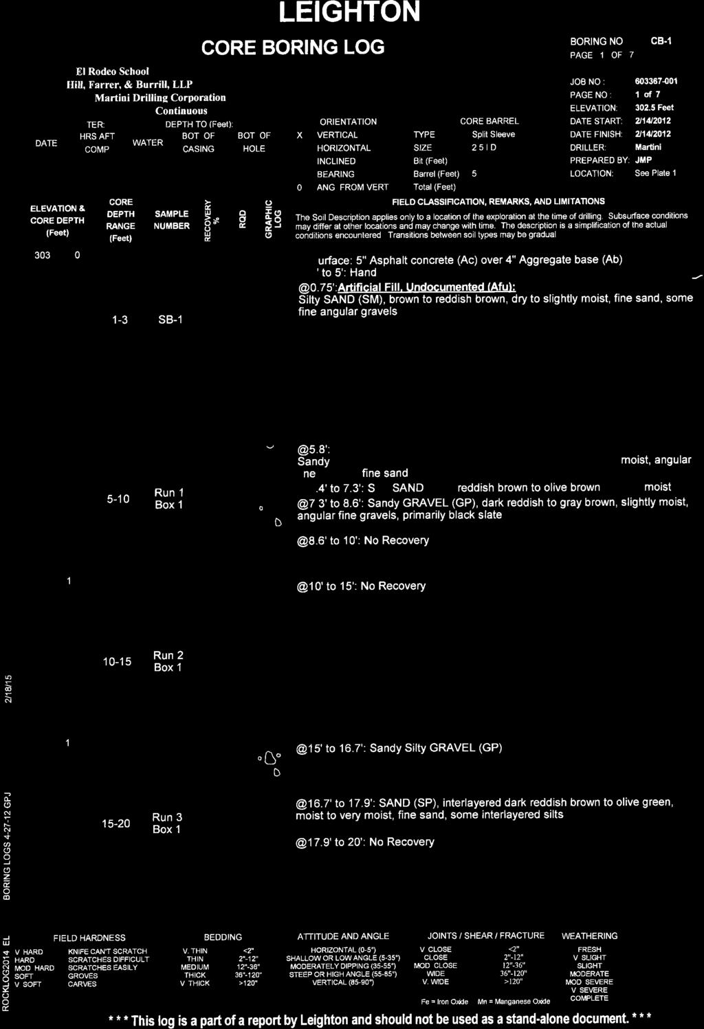
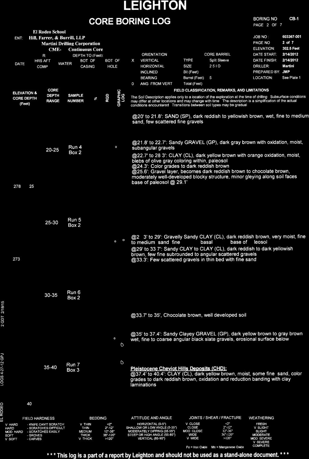
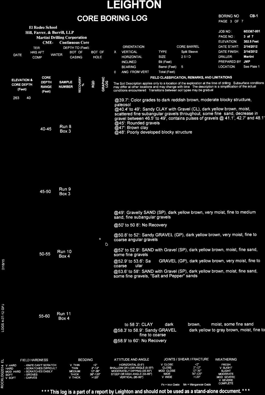
|
|
|
- Joseph Stanley
- 6 years ago
- Views:
Transcription
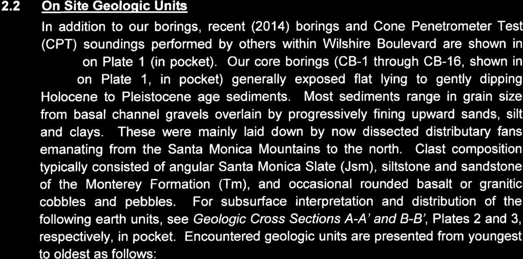
1
2

3

4
5

6
7
8
9
10
11
12
13
14
15
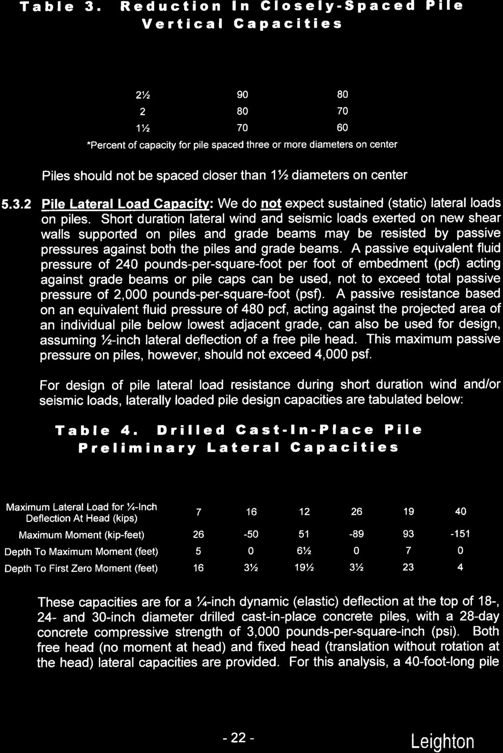
16
17
18
19
20
21
22
23
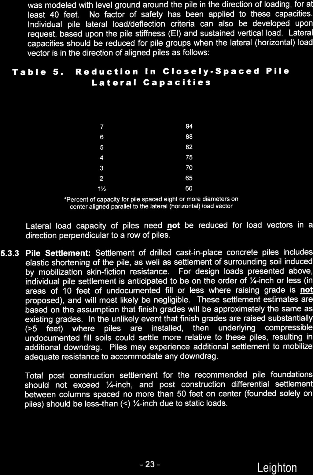
24
25
26
27

28
29
30
31
32
33
34
35
36
37
38
39
40
41
42

43

44
45
46
47
48
49
50
51
52
53
54
55
56
57
58
59
60
61
62
63
64
65
66
67
68
69
70
71
72
73
74
75
76
77
78
79
80
81
82
83
84
85
86
87
88
89
90
91
92
93
94
95
96
97
98
99
100
101
102
103
104
105
106
107
108
109
110
111
112
113
114
115
116
117
118
119
120
121
122
123
124
125
126
127
128
129
130
131
132
133
134
135
136
137
138
139
140
141
142
143
144
145
146

147
148
149


150


151
152

153


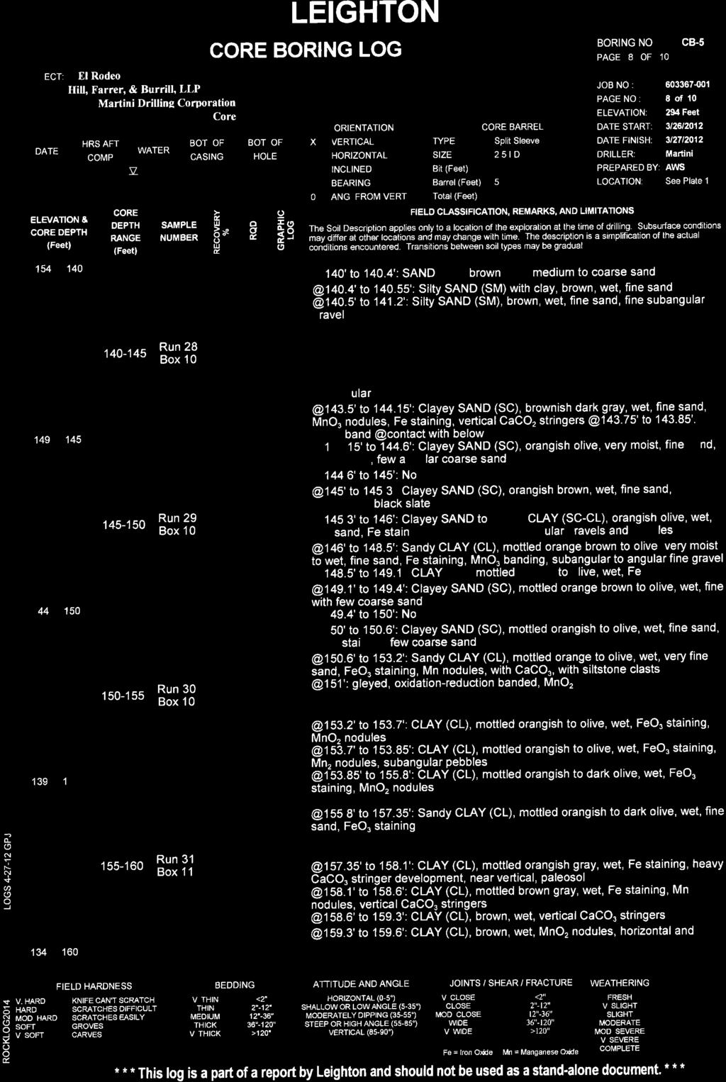
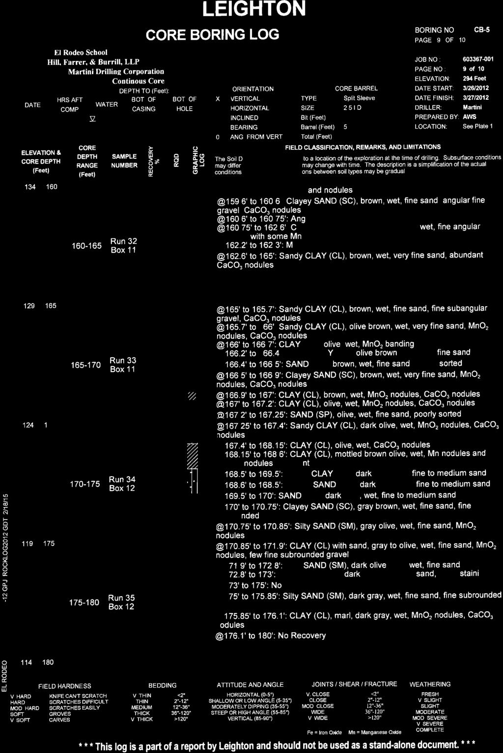
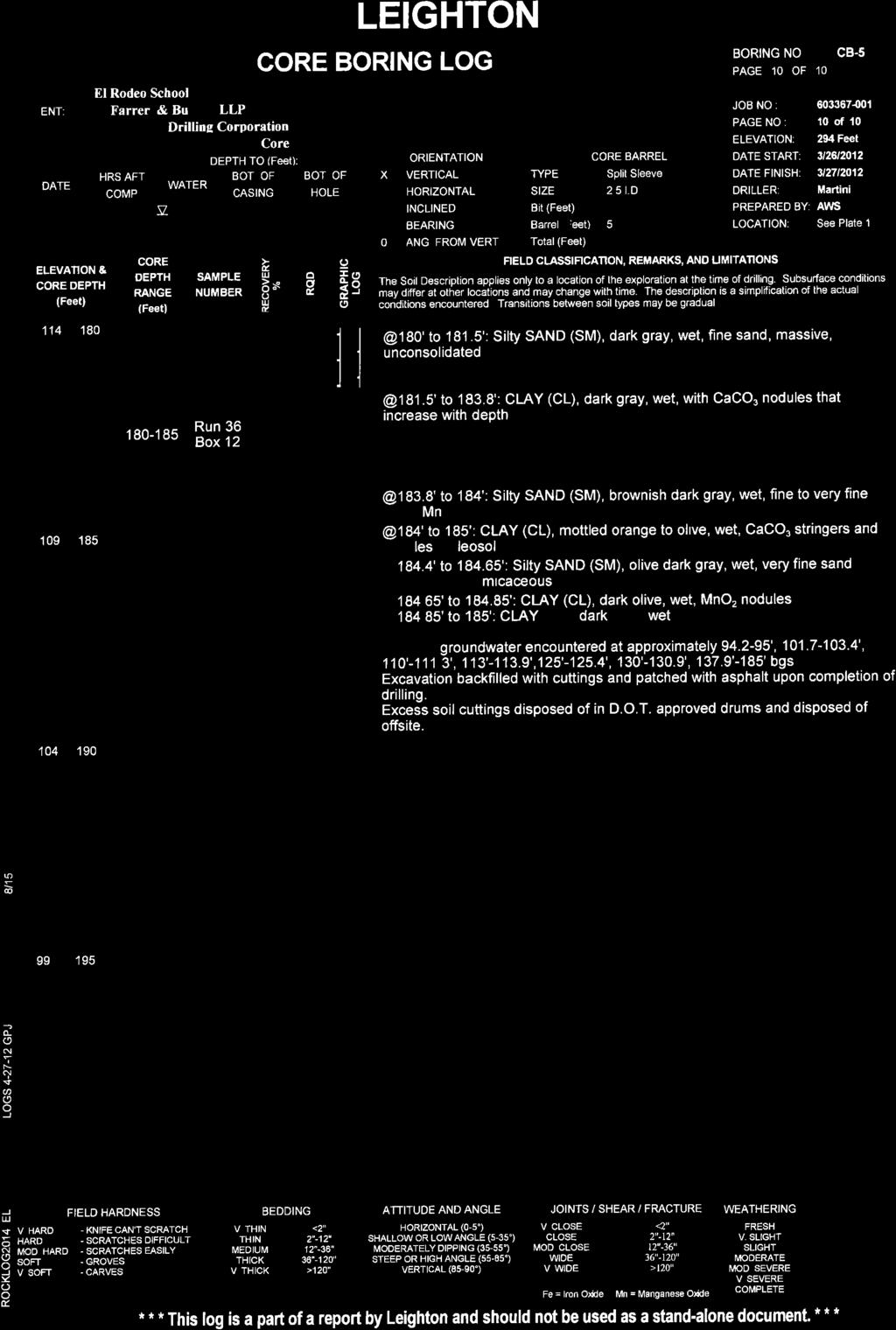
154
155
156
157

158
159
160
161
162
163

164
165
166
167
168
169

170
171
172
173
174
175
176

177
178
179
180

181

182

183

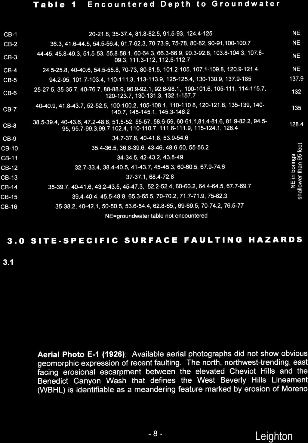
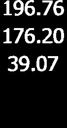
: Silty sand to clayey sand grading to sand at depth, with minor gravel and thin gravel beds; light yellowish")
: Sandy clay to clayey sand grading laterally to silty sand to sand with silt; coarsening downward near the thalweg of the channel to sand with gravel,")
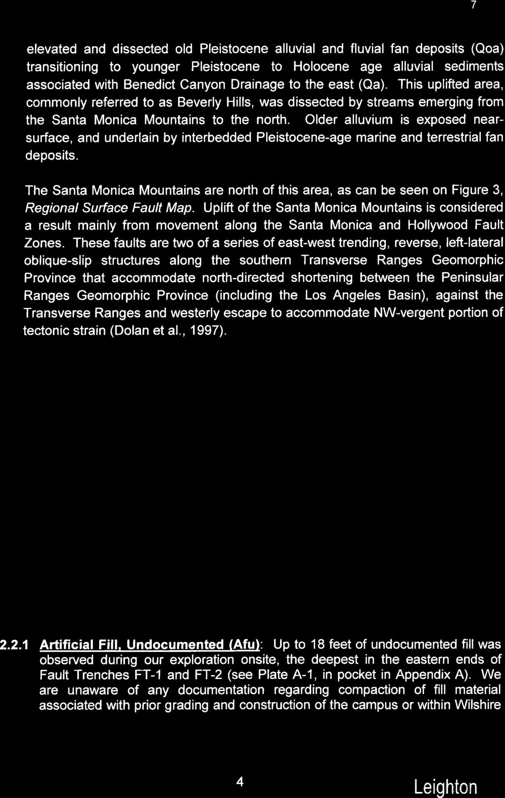
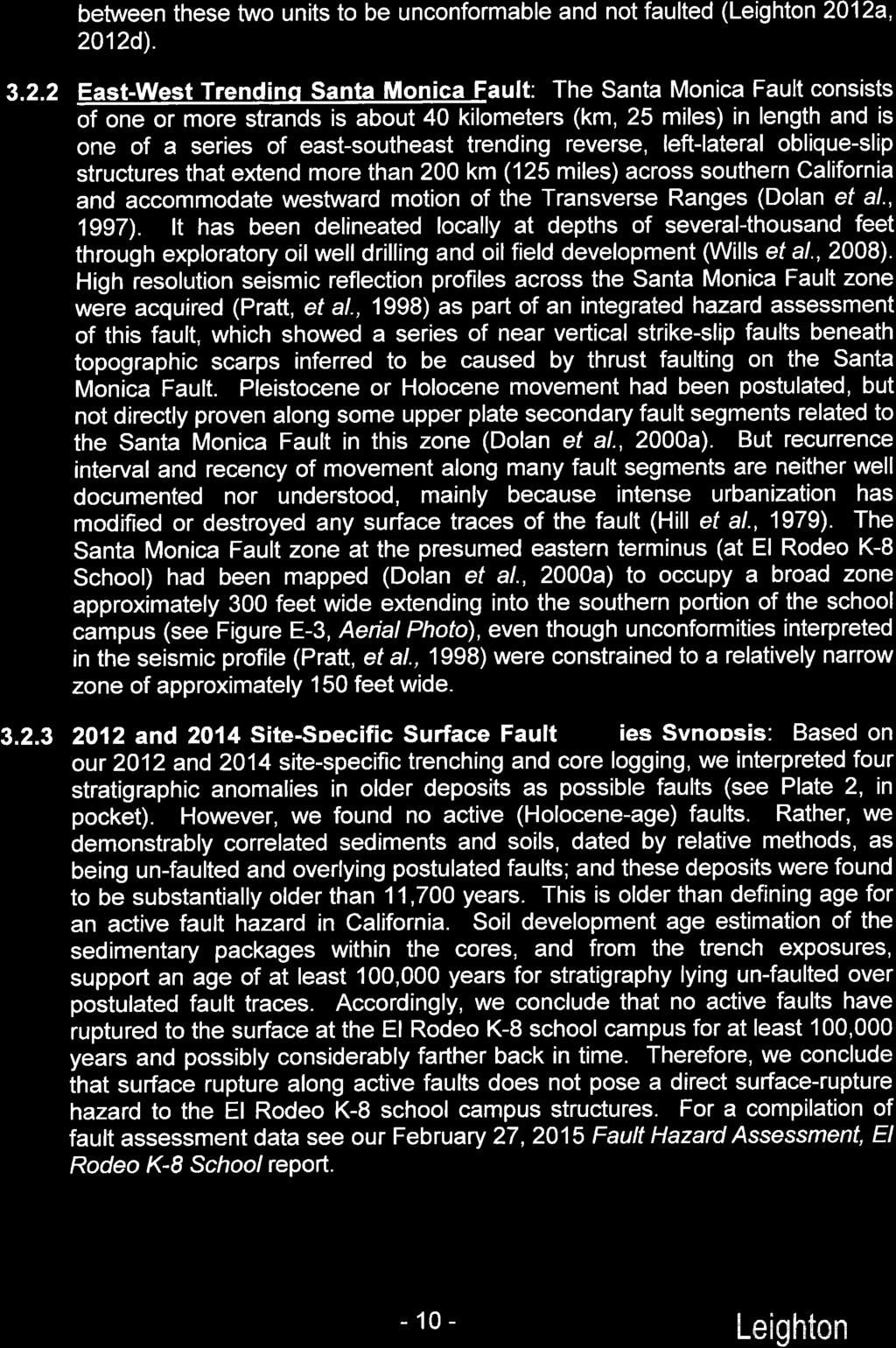
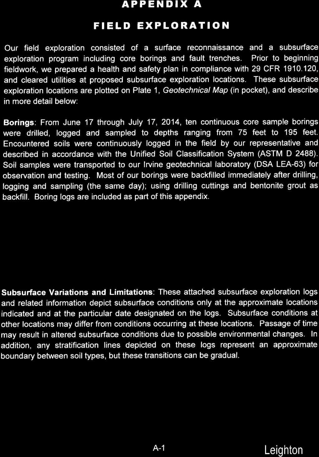
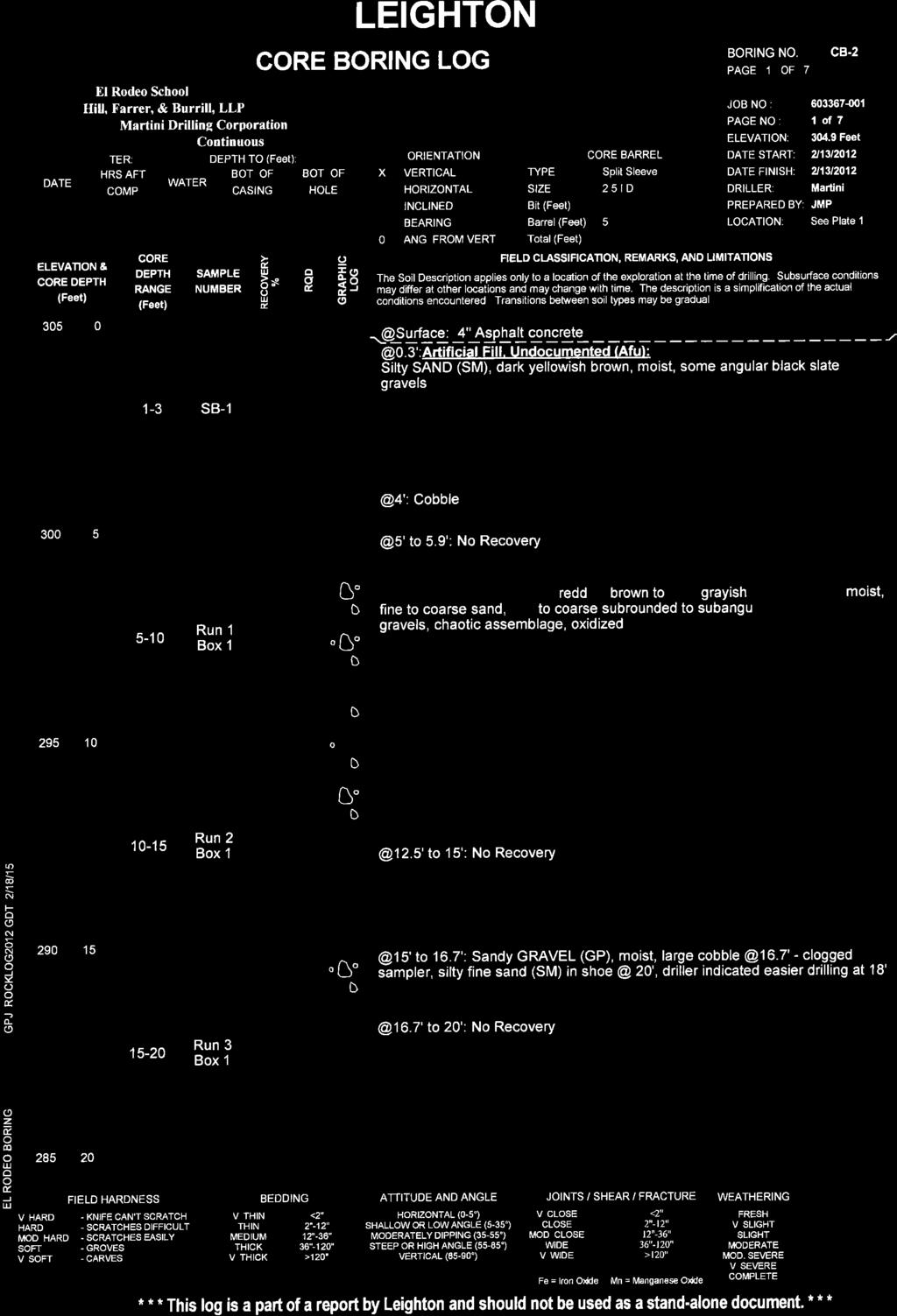
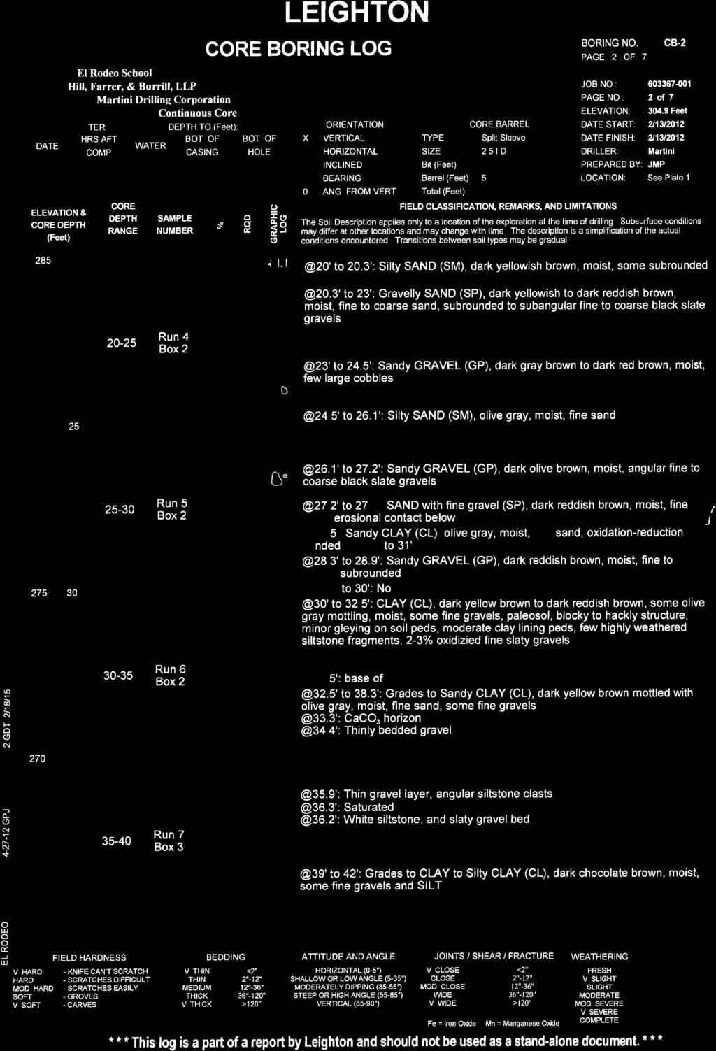
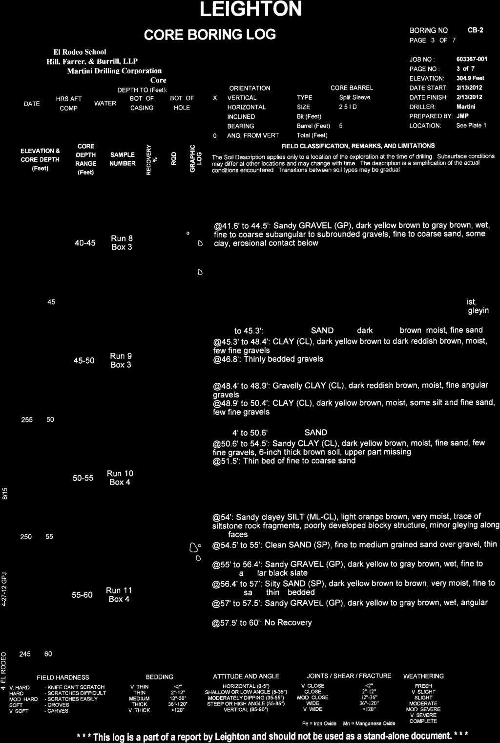
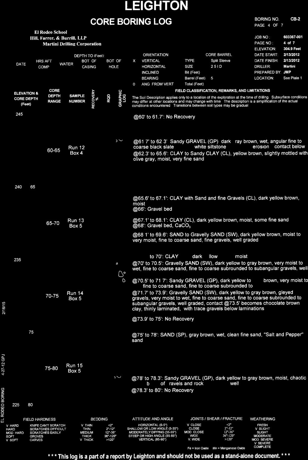
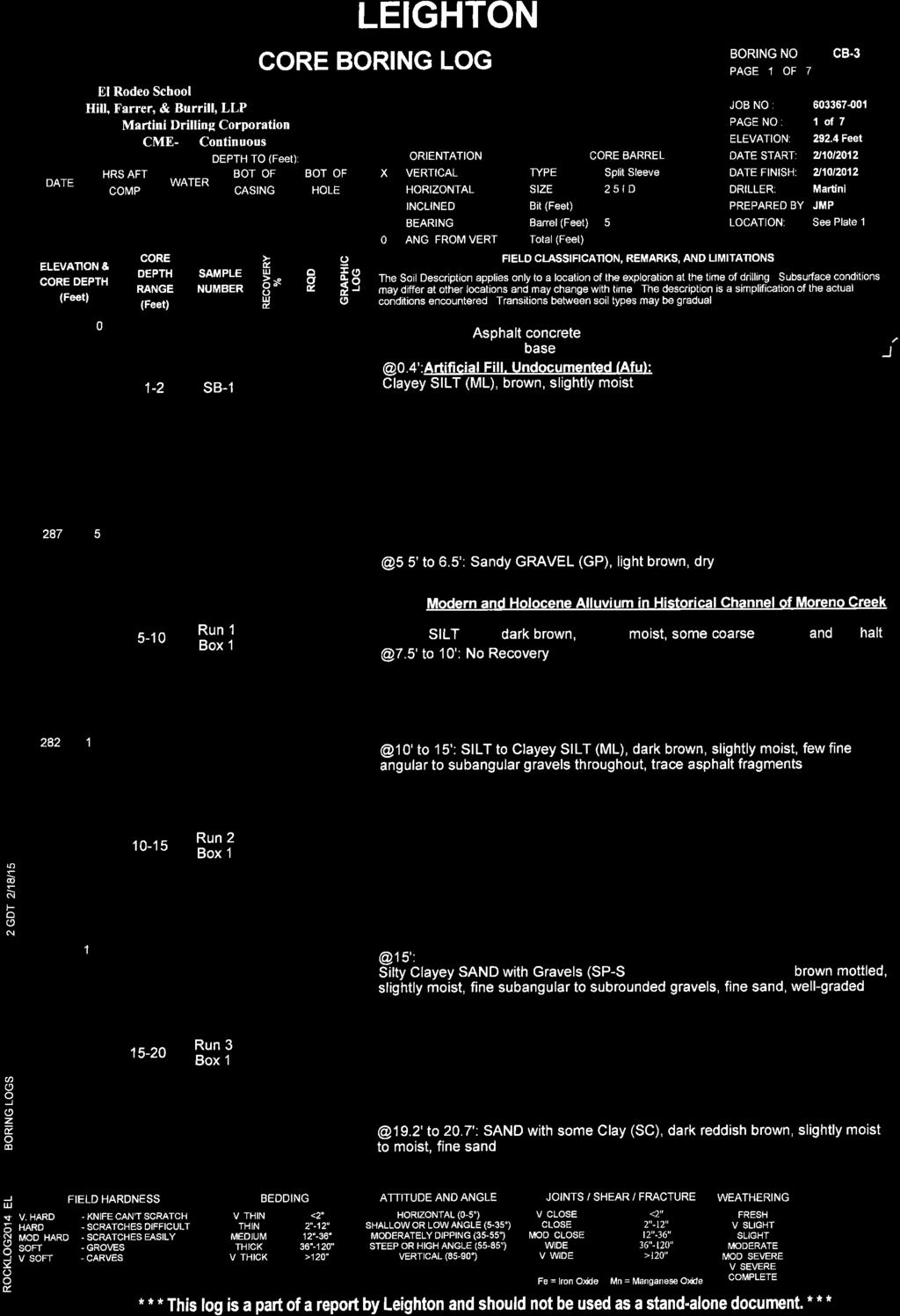
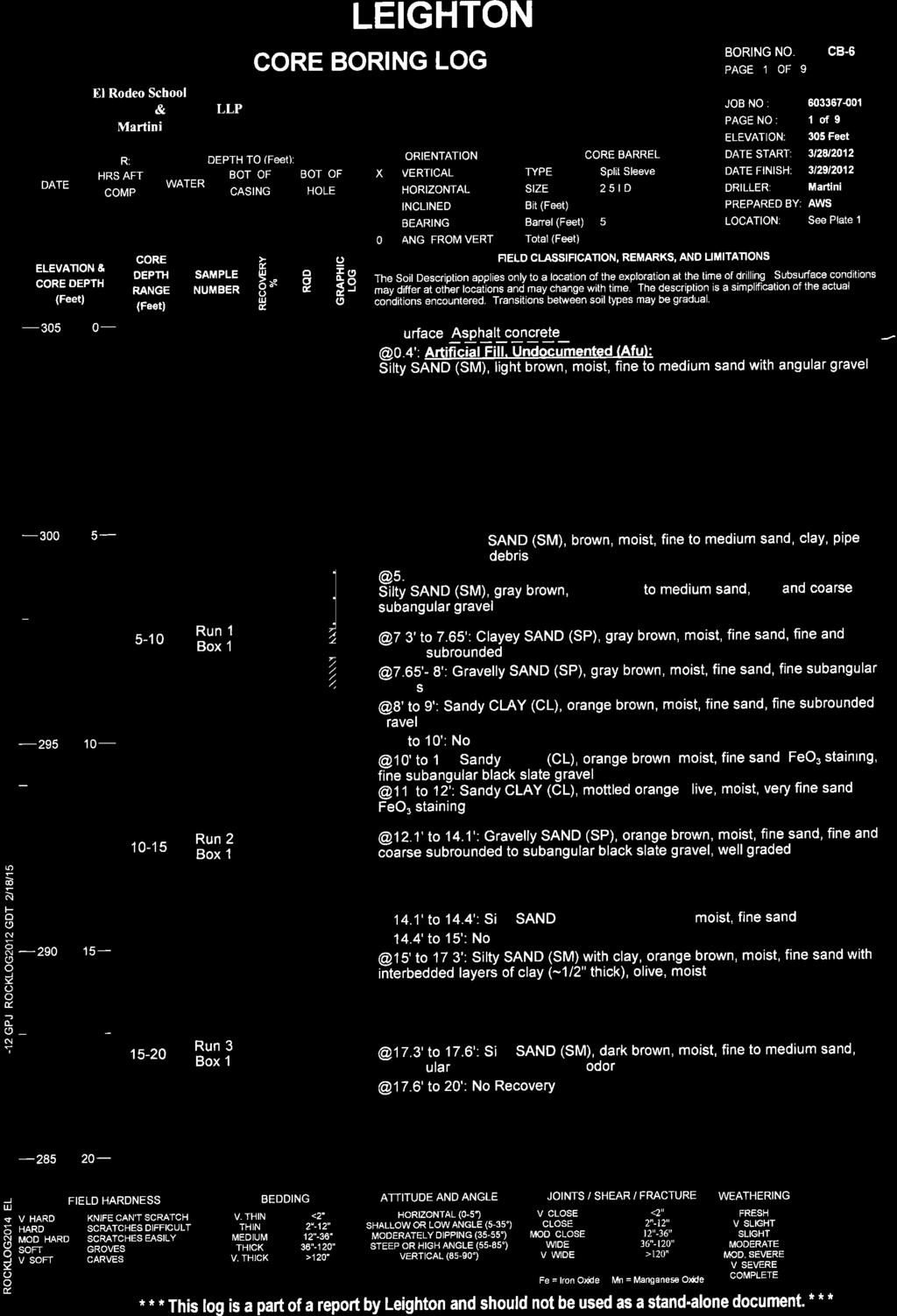
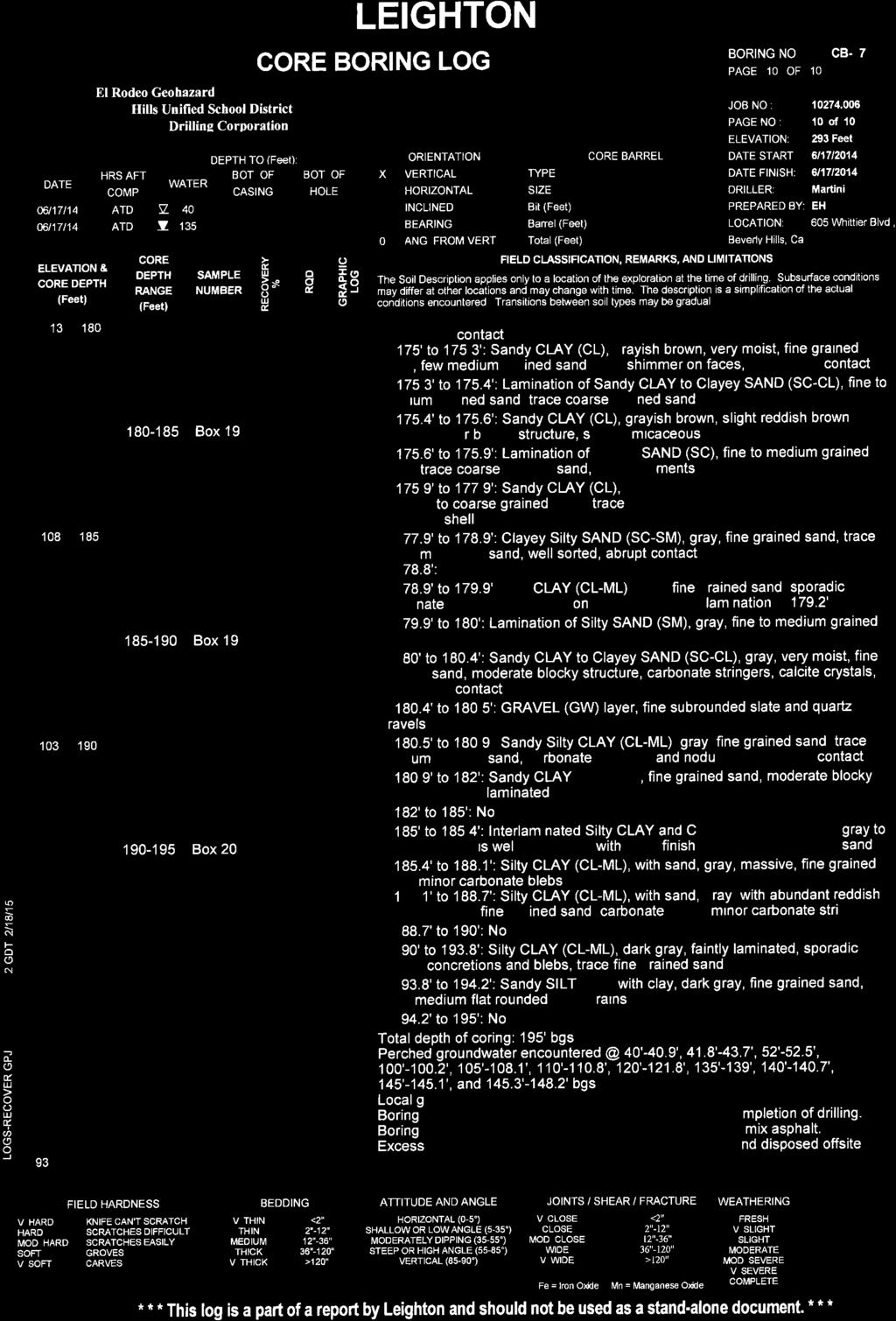
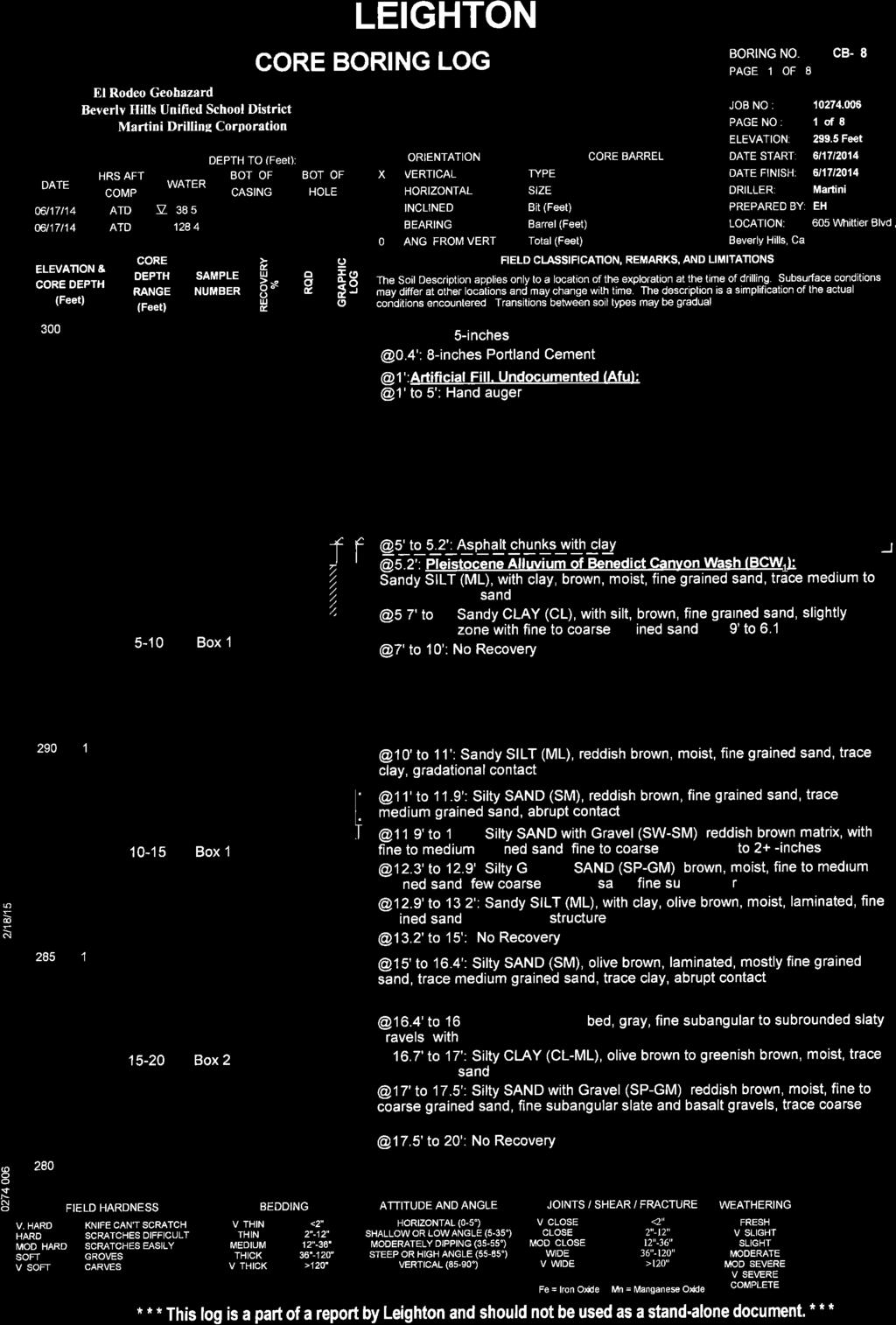
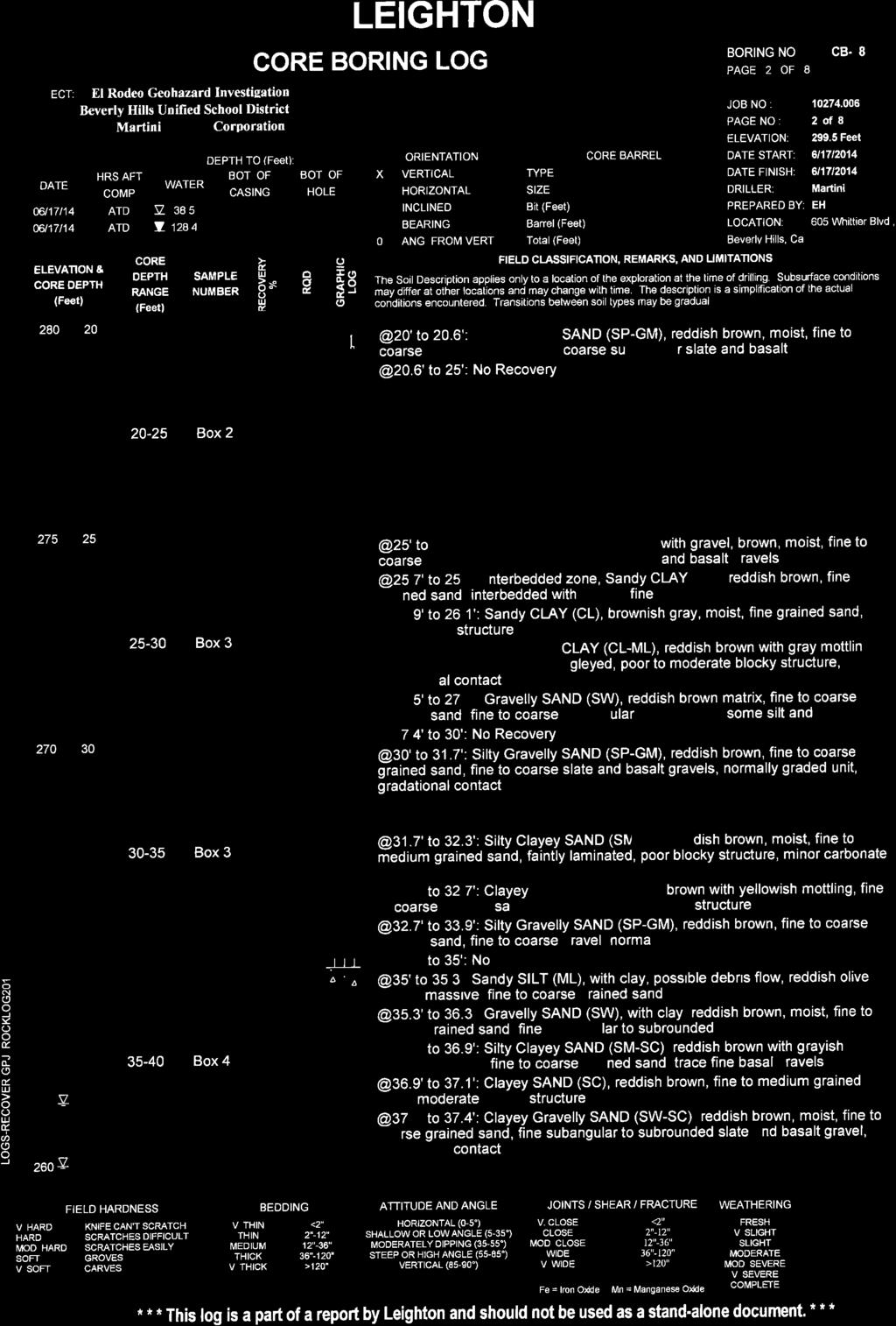
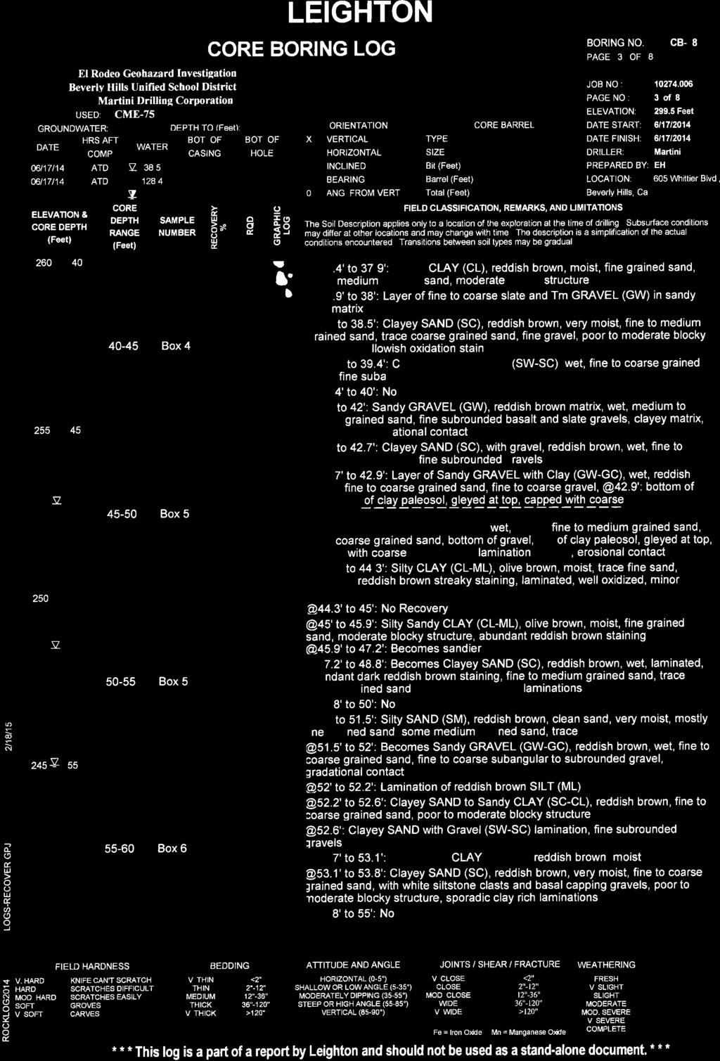
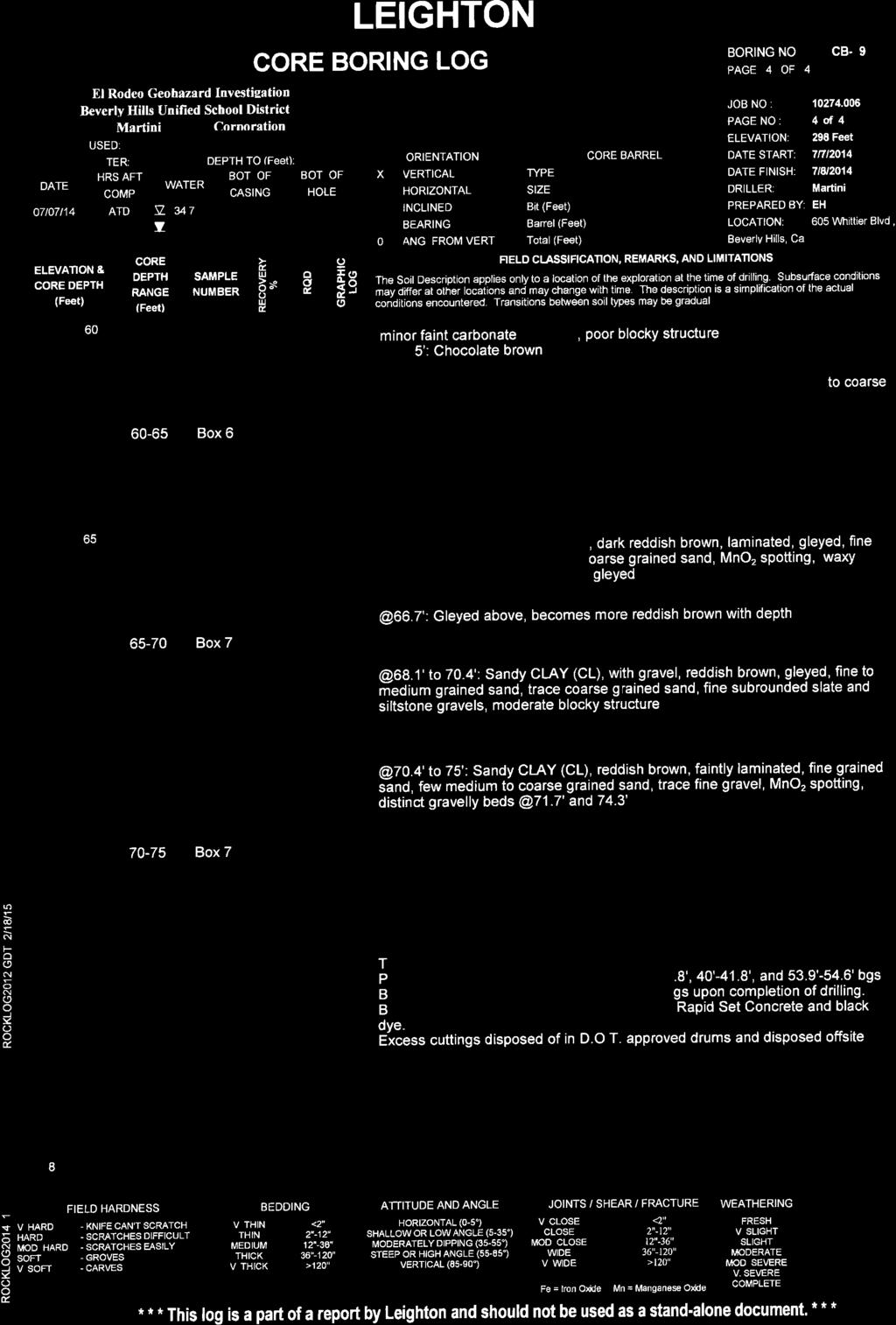
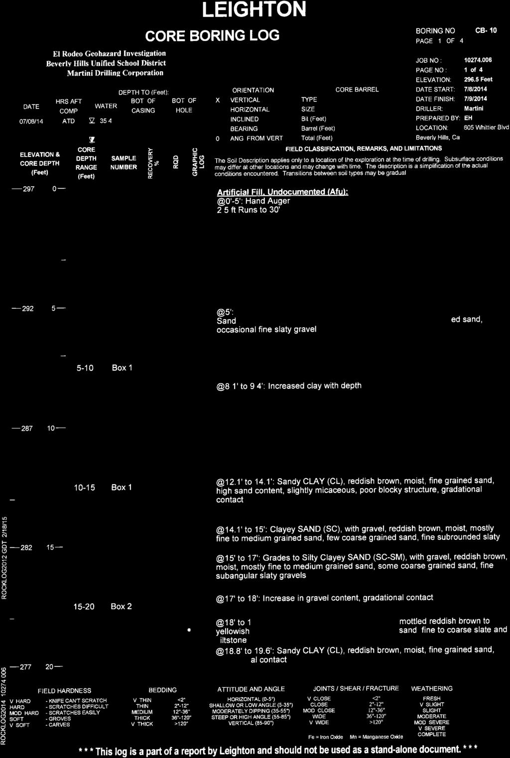
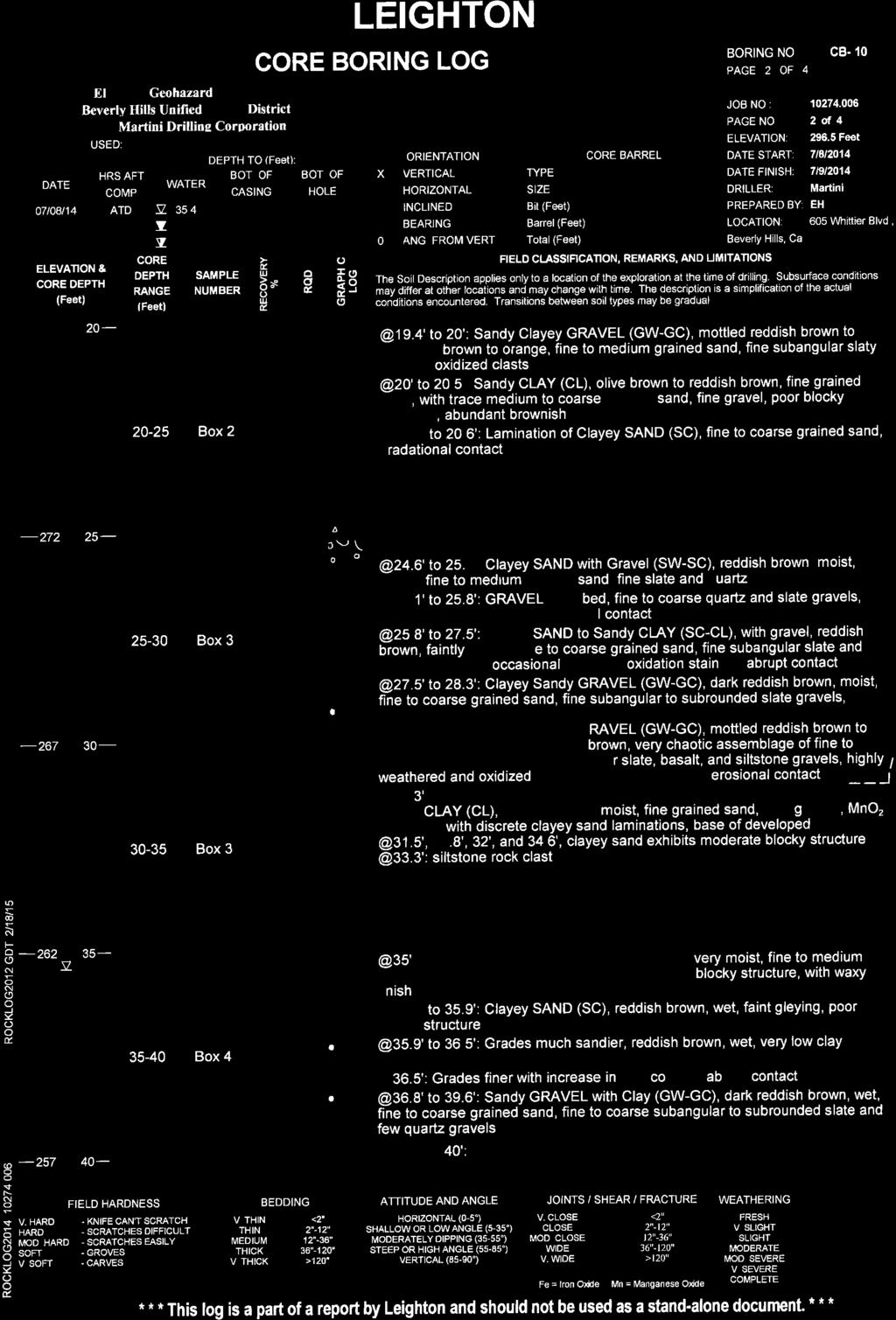
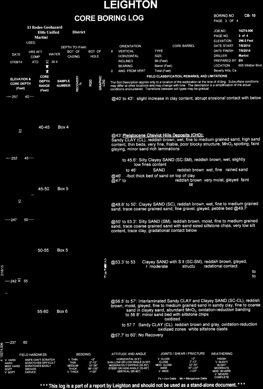
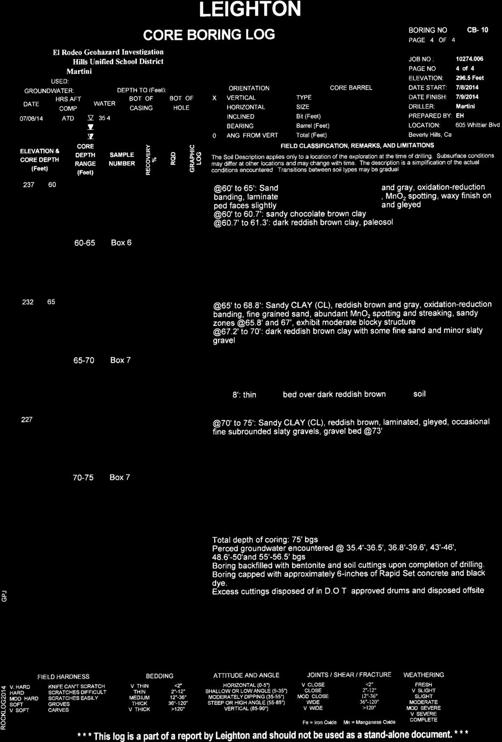
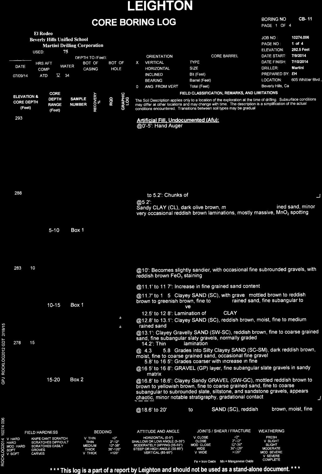
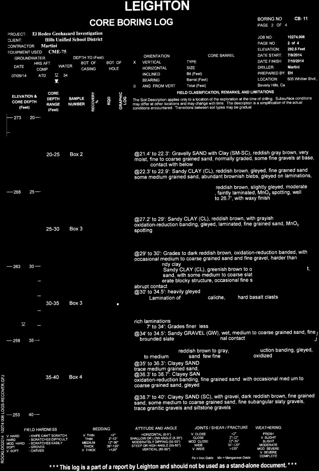
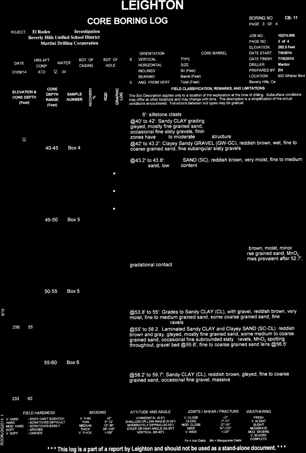
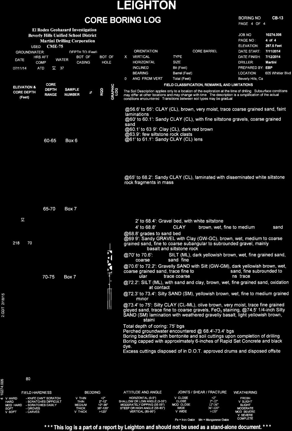
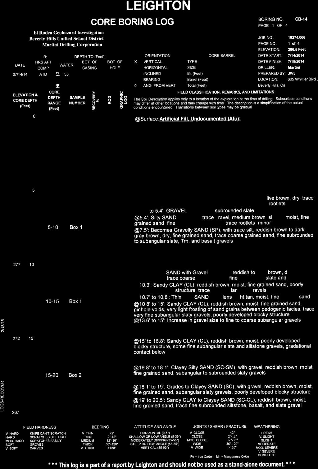
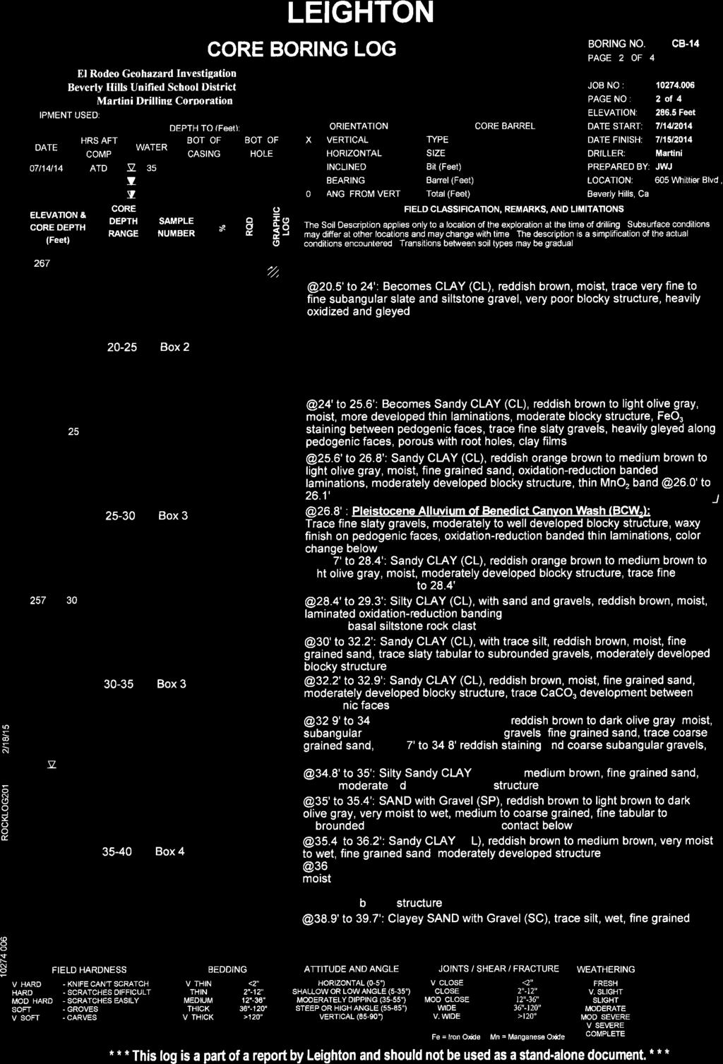
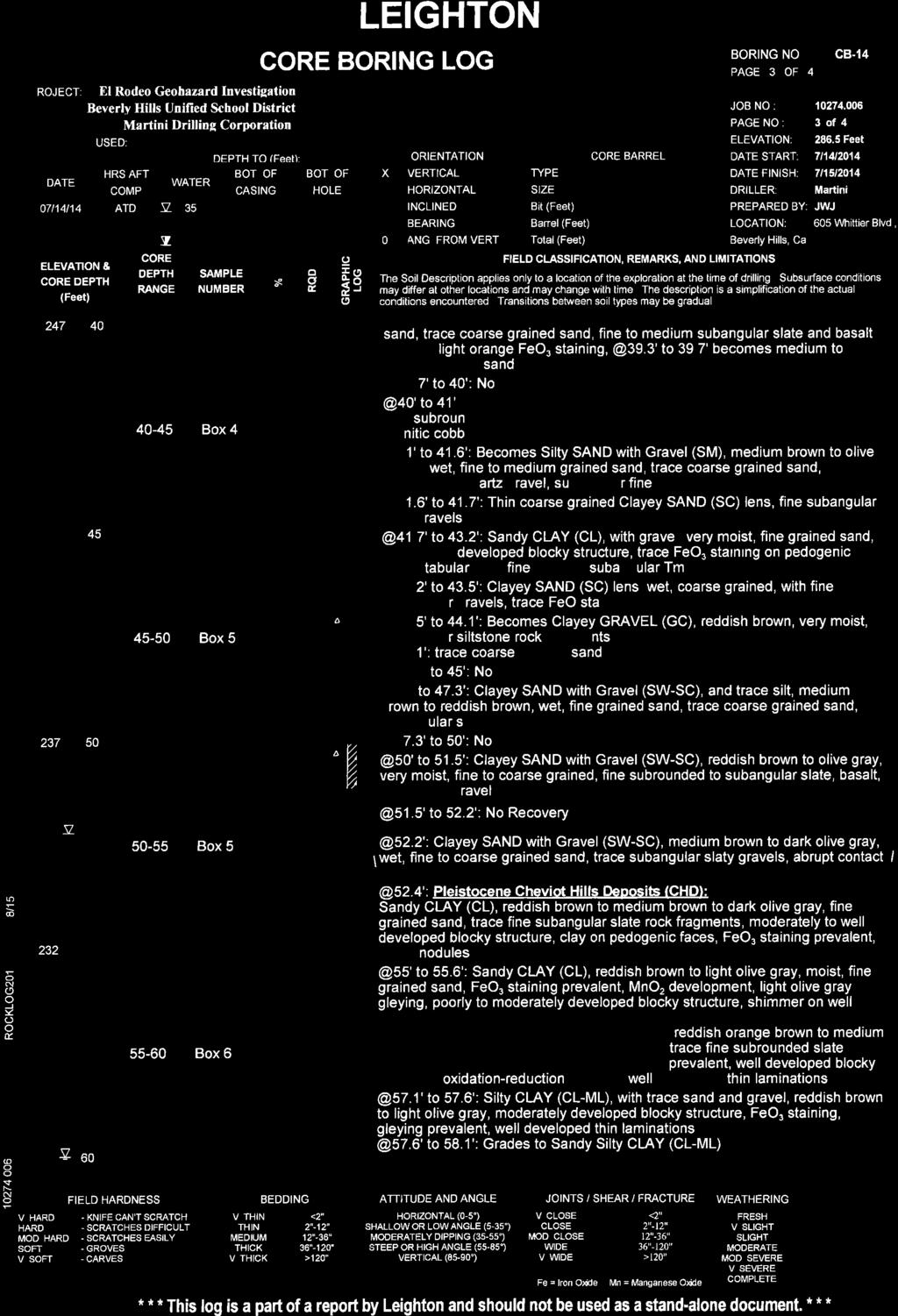
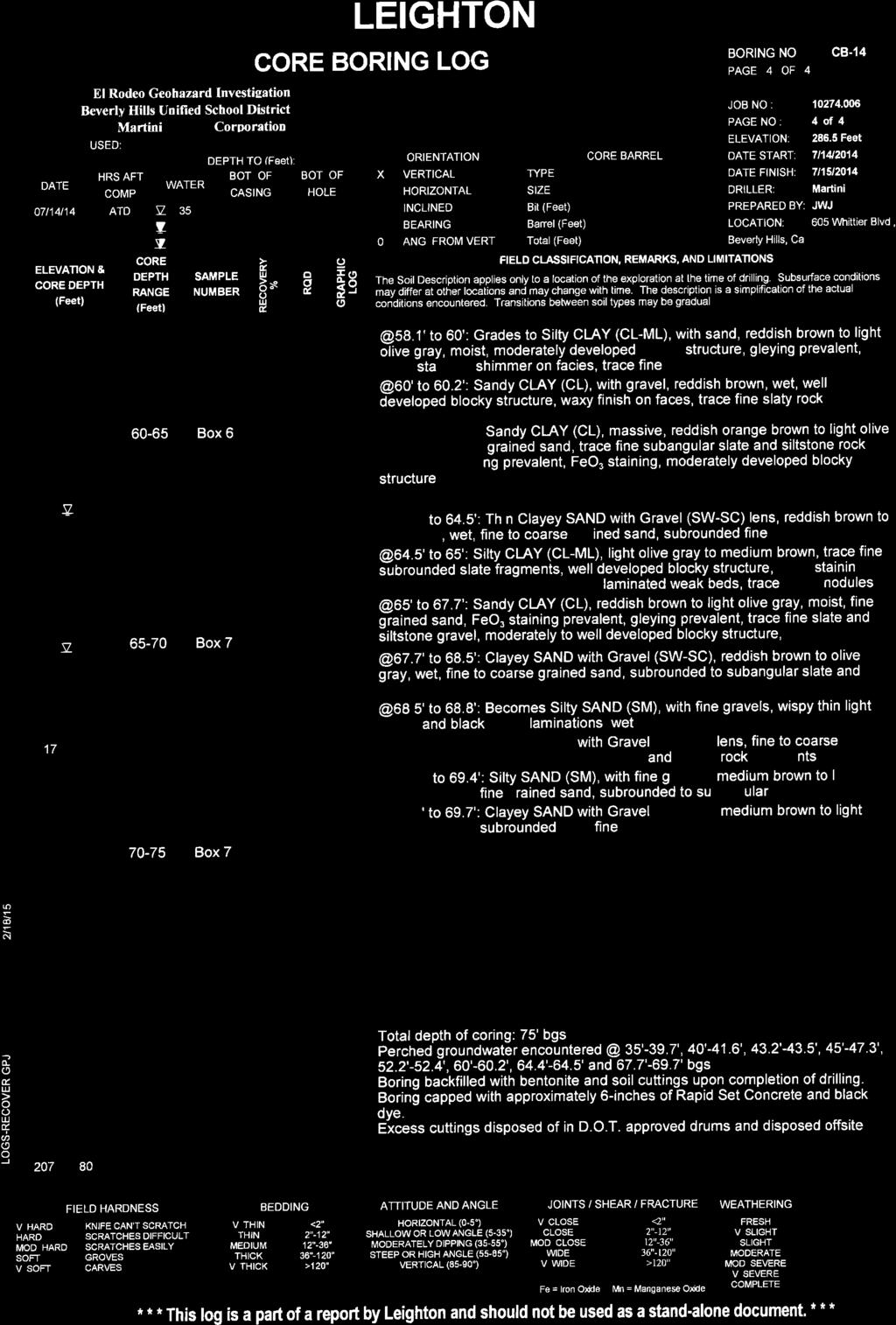
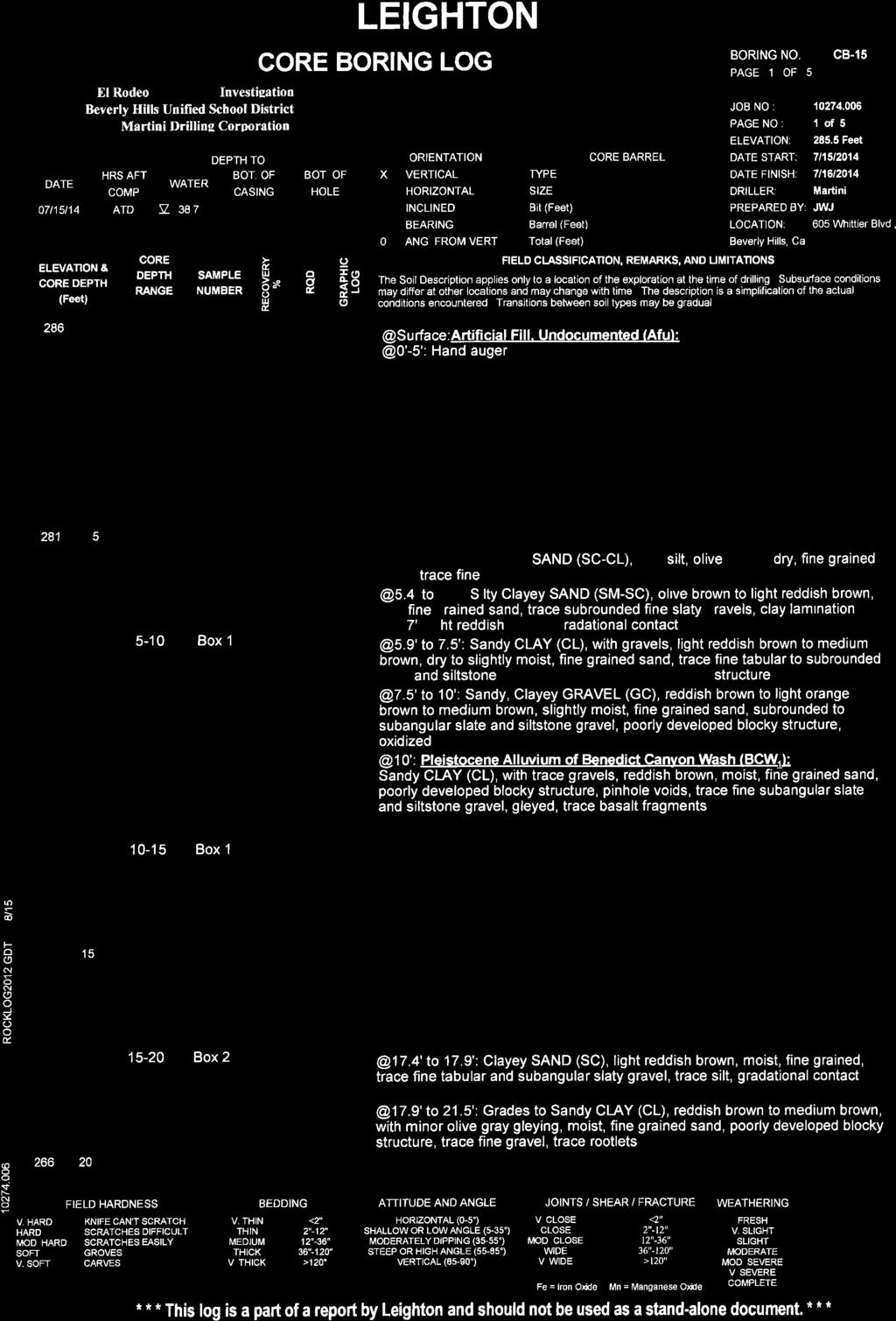
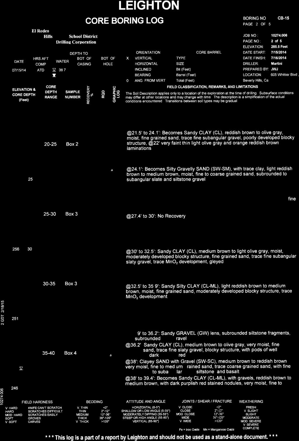
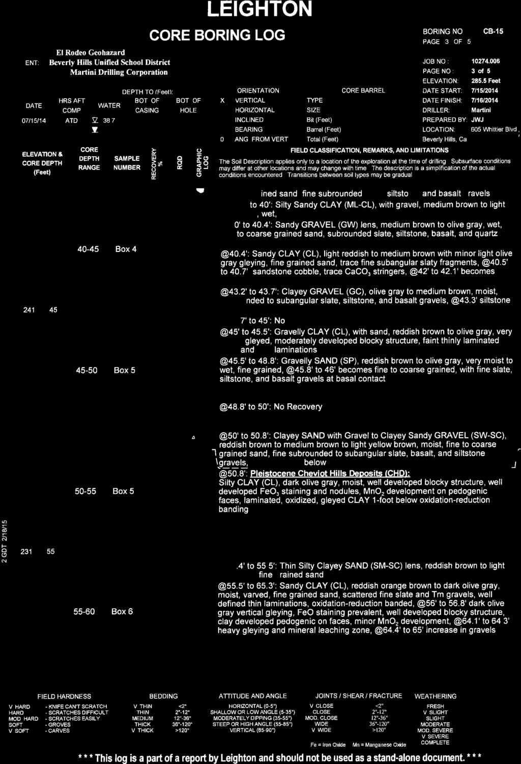
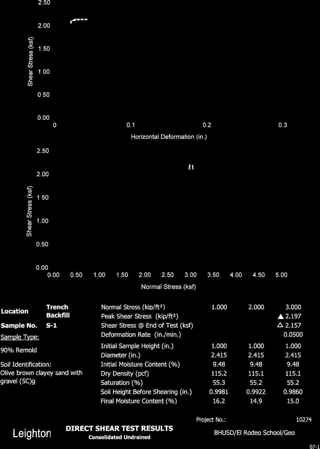
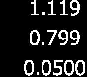
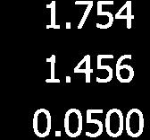
184 UNIT DESCRIPTIONS: Artificial Fill, Undocumented (Afu): Locally derived sandy silt and silty sand, locally with clay and varying amounts of gravel and man-made debris. Abundant concrete rubble, in places exceeding 24-inches in diameter, observed in the backfill of Moreno Creek drainage in trenches FT-1 and FT-2. Localized seepage along root traces observed in backfill along southern sidewall of trench FT-1 and near storm drain inlet of trench FT-2. In Cross-Sections Modern and Holocene Alluvium in Historical Channel of Moreno Creek (Qw): Silty sand to clayey sand grading to sand at depth, with minor gravel and thin gravel beds; light yellowish brown, brown to dark reddish brown; massive to crudely stratified; small fragments of asphalt observed locally in CB-3. Holocene Alluvium of Benedict Canyon Wash (Qal): Sandy clay to clayey sand grading laterally to silty sand to sand with silt; coarsening downward near the thalweg of the channel to sand with gravel, sandy gravel or gravelly sand; brown, dark yellowish brown, dark brown to reddish brown; locally laminated; gravel consist of fine- to coarse-grained subangular to subrounded fragments of siltstone and slate; few to common manganese oxide and iron oxide stains; few roots. Pleistocene Alluvium of Benedict Canyon Wash (BCW1): Sandy clay, clayey sand, sand with clay, and silty sand with clay, grading laterally to silty sand and sand with silt; near the channel centerline, deposit coarsens downward to gravelly sand to clayey sand with gravel; dark yellowish brown, brown, dark brown to reddish brown; mottled; locally gleyed; slightly moist to moist; massive to thinly laminated; few to many scattered gravel that consist of subangular to subrounded and tabular fragments of siltstone, slate and weathered basalt. Terrestrial deposit consisting of fluvial, alluvial fan, and mudflow sediments emanating from the Santa Monica Mountains via Benedict Canyon Wash and its tributaries. Pleistocene Alluvium of Benedict Canyon Wash (BCW2): Sandy clay, clayey sand and silty clay grading laterally to silty sand to sand with silt; with lenses and interbeds of sandy gravel; coarsening downwards to a basal channel deposit of sand, gravelly sand and gravel; dark grayish brown, reddish brown, very dark brown, and dark yellowish brown; locally mottled and/or gleyed; oxidation-reduction banding; iron oxide and manganese oxide stains common on rock clasts and along basal channel contact; gravel consist of fine- to medium-grained subrounded to subangular fragments of siltstone, slate, basalt and quartz. Unit is characterized by moderate to well-developed paleosols with many moderately thick to thick clay films on ped faces and moderate to strong angular blocky soil structure. Distinctive erosional contact with underlying Cheviot Hills deposits. Pleistocene Cheviot Hills Deposits (CHD): Sandy clay, clayey sand, and silty clay; with thin silty sand and gravel layers and beds; brown, reddish brown, brown, and grayish brown; locally gleyed; moist to wet along sand beds; manganese oxide stains, streaks and nodules; iron oxide stains on rock fragments, and forming oxidation-reduction banding; gravel consist of subrounded to subangular fragments of siltstone and slate. At depth, unit includes abundant calcium carbonate in the form of specks, filaments, horizontal layers, and coatings on ped faces; color changes to grayish brown, gray, and blue green reminiscent of the Lomita Marl; iron oxide staining along layers and locally on ped faces. Unit has been modified by soil-forming processes, with pedogenic characteristics, including clay films on ped faces and moderate to strong angular blocky soil structure, observed at several intervals, including directly at or below its contact with the overlying Benedict Canyon Wash deposits. Terrestrial deposit consisting of fluvial and alluvial sediments derived from the San Pedro Formation deposited over a long period of time, with depositional hiatuses that allowed for soil development. This unit was exposed at the surface for thousands of years before it was buried by the Pleistocene alluvium of Benedict Canyon Wash. CaCO3 stringers and along soil faces as vertical deposits Silty SAND (SM) CaCO 3 nodules SAND (SP) Denotes poor to well developed soil structure Geologic contact, dashed where approximate, querried where uncertain Rock Clasts Quaternary San Pedro Formation (Qsp): Sand with scattered gravel; few silty to clayey laminations; yellow, olive brown to reddish orange brown; loose to hard; dry near upper contact, becoming moist to wet at depth; sand fraction consists of fine to coarse, well-rounded quartz grains; scattered bi-valve shell fragments. Transitional terrestrial to marine unit deposited in a wave-dominated (beach) environment. Fault contact, dashed where approximate, querried where uncertain, arrows denote inferred direction of movement. Trend Unknown CLAY with proportional amounts of silt and/or sand (CL, CL-ML) GRAVEL with varying proportions of silt and sand (GP-GM) Clayey SAND (SC) GRAVEL with CLAY (GC) GEOLOGIC CROSS SECTION A-A' SILT with proportional amounts of clay and sand (ML, ML-CL) PLATE 2 EL RODEO 605 WHITTIER DRIVE BEVERLY HILLS, CALIFORNIA NO RECOVERY Proj: Eng/Geol: TCB/JAR Scale: 1"=10' Date: 02/2015 Drafted By: BQT Checked By: BQT P:\DRAFTING\10274\006\OF_ \ PLATE-2 SECTION.DWG ( :18:06AM) Plotted by: mmurphy Leighton
185 CaCO 3 stringers and along soil faces as vertical deposits CaCO 3 nodules Denotes poor to well developed soil structure Geologic contact, dashed where approximate, querried where uncertain Rock Clasts Fault contact, dashed where approximate, querried where uncertain, arrows denote inferred direction of movement CLAY with proportional amounts of silt and/or sand (CL, CL-ML) CLAYEY SAND (SC) SILT with proportional amounts of clay and sand (ML, ML-CL) Silty SAND (SM) SAND (SP) GRAVEL with varying proportions of silt and sand (GP-GM) GRAVEL with CLAY (GC) No Recovery (N/R) UNIT DESCRIPTIONS: Artificial Fill, Undocumented (Afu): Locally derived sandy silt and silty sand, locally with clay and varying amounts of gravel and man-made debris. Abundant concrete rubble, in places exceeding 24-inches in diameter, observed in the backfill of Moreno Creek drainage in trenches FT-1 and FT-2. Localized seepage along root traces observed in backfill along southern sidewall of trench FT-1 and near storm drain inlet of trench FT-2. In Cross-Sections A-A and B-B, this unit includes the section not logged from the auger spoils and the hand-augered section at the top of the CPTs. Modern and Holocene Alluvium in Historical Channel of Moreno Creek (Qw): Silty sand to clayey sand grading to sand at depth, with minor gravel and thin gravel beds; light yellowish brown, brown to dark reddish brown; massive to crudely stratified; small fragments of asphalt observed locally in CB-3. Holocene Alluvium of Benedict Canyon Wash (Qal): Sandy clay to clayey sand grading laterally to silty sand to sand with silt; coarsening downward near the thalweg of the channel to sand with gravel, sandy gravel or gravelly sand; brown, dark yellowish brown, dark brown to reddish brown; locally laminated; gravel consist of fine- to coarse-grained subangular to subrounded fragments of siltstone and slate; few to common manganese oxide and iron oxide stains; few roots. Pleistocene Alluvium of Benedict Canyon Wash (BCW1): Sandy clay, clayey sand, sand with clay, and silty sand with clay, grading laterally to silty sand and sand with silt; near the channel centerline, deposit coarsens downward to gravelly sand to clayey sand with gravel; dark yellowish brown, brown, dark brown to reddish brown; mottled; locally gleyed; slightly moist to moist; massive to thinly laminated; few to many scattered gravel that consist of subangular to subrounded and tabular fragments of siltstone, slate and weathered basalt. Terrestrial deposit consisting of fluvial, alluvial fan, and mudflow sediments emanating from the Santa Monica Mountains via Benedict Canyon Wash and its tributaries. Pleistocene Alluvium of Benedict Canyon Wash (BCW2): Sandy clay, clayey sand and silty clay grading laterally to silty sand to sand with silt; with lenses and interbeds of sandy gravel; coarsening downwards to a basal channel deposit of sand, gravelly sand and gravel; dark grayish brown, reddish brown, very dark brown, and dark yellowish brown; locally mottled and/or gleyed; oxidation-reduction banding; iron oxide and manganese oxide stains common on rock clasts and along basal channel contact; gravel consist of fine- to medium-grained subrounded to subangular fragments of siltstone, slate, basalt and quartz. Unit is characterized by moderate to well-developed paleosols with many moderately thick to thick clay films on ped faces and moderate to strong angular blocky soil structure. Distinctive erosional contact with underlying Cheviot Hills deposits. Pleistocene Cheviot Hills Deposits (CHD): Sandy clay, clayey sand, and silty clay; with thin silty sand and gravel layers and beds; brown, reddish brown, brown, and grayish brown; locally gleyed; moist to wet along sand beds; manganese oxide stains, streaks and nodules; iron oxide stains on rock fragments, and forming oxidation-reduction banding; gravel consist of subrounded to subangular fragments of siltstone and slate. At depth, unit includes abundant calcium carbonate in the form of specks, filaments, horizontal layers, and coatings on ped faces; color changes to grayish brown, gray, and blue green reminiscent of the Lomita Marl; iron oxide staining along layers and locally on ped faces. Unit has been modified by soil-forming processes, with pedogenic characteristics, including clay films on ped faces and moderate to strong angular blocky soil structure, observed at several intervals, including directly at or below its contact with the overlying Benedict Canyon Wash deposits. Terrestrial deposit consisting of fluvial and alluvial sediments derived from the San Pedro Formation deposited over a long period of time, with depositional hiatuses that allowed for soil development. This unit was exposed at the surface for thousands of years before it was buried by the Pleistocene alluvium of Benedict Canyon Wash. Quaternary San Pedro Formation (Qsp): Sand with scattered gravel; few silty to clayey laminations; yellow, olive brown to reddish orange brown; loose to hard; dry near upper contact, becoming moist to wet at depth; sand fraction consists of fine to coarse, well-rounded quartz grains; scattered bi-valve shell fragments. Transitional terrestrial to marine unit deposited in a wave-dominated (beach) environment. PLATE 3 GEOLOGIC CROSS-SECTION B-B' EL RODEO 605 WHITTIER DRIVE BEVERLY HILLS, CALIFORNIA Leighton Proj: Eng/Geol: TCB/JAR Vertical: 1"=10' Horizontal: 1"=20' Scale: Date: 02/2015 Drafted By: MAM Checked By: P:\DRAFTING\10274\006\OF_ \ PLATE-3 SECTION.DWG ( :23:15AM) Plotted by: mmurphy
186
APPENDIX C HYDROGEOLOGIC INVESTIGATION
 Figure B-5.7 Figure B-5.8 Preliminary Geotechnical and Environmental Report Appendix C Hydrogeologic Investigation APPENDIX C HYDROGEOLOGIC INVESTIGATION December 21, 2011 WESTSIDE SUBWAY EXTENSION PROJECT
 Photo 1 - Southerly view across 2700 parking lot toward existing building. Multi-residential building borders western side of property in upper right of view. Photo 2 - Southerly view across 2750 parking
Log of Monitoring Well D58B
 Project: Motiva - Monitoring Well and Soil Boring Data Project Location: Delaware City Refinery Project Number: 20240412.W1000 Log of Monitoring Well D58B Sheet 1 of 7 Date(s) Drilled Drilling Method Drill
 TP-1 N61E 0 DARK BROWN SANDY SILT (ML) stiff, wet with roots (Disturbed Surficial Soil) DEPTH (FEET) 5 REDDISH BROWN SANDSTONE intensely fractured, weak to friable, deeply weathered, tight (Franciscan
 SOIL CLASSIFICATION CHART COARSE-GRAINED SOILS MORE THAN 50% RETAINED ON NO.200 SIEVE FINE-GRAINED SOILS 50% OR MORE PASSES THE NO.200 SIEVE PRIMARY DIVISIONS GRAVELS MORE THAN 50% OF COARSE FRACTION RETAINED
Feet. SAND; clayey, fine grained; shells are common; rounded quartz grains. SHELLS; muddy; almost no sand, shells and fragments common
 SAND; clayey, fine grained; shells are common; rounded quartz grains SHELLS; muddy; almost no sand, shells and fragments common SAND; back to medium to fine; has a mottled appearance and looks burrowed;
Appendix G GEOLOGICAL INVESTIGATION
 Appendix G GEOLOGICAL INVESTIGATION JOB NUMBER: 3268.001 DATE: 10-14-13 BY: CC SITE 0 2000 1"=2000' VICINITY MAP CARGILL PARCEL HICKORY STREET AND ENTERPRISE DRIVE NEWARK, CALIFORNIA FOR
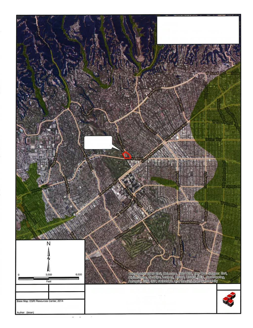
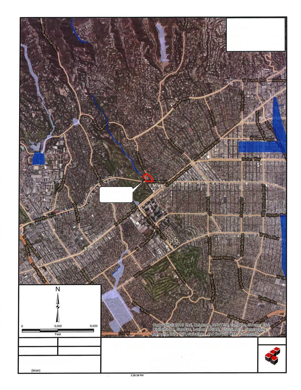
REPORT OF FAULT SURFACE RUPTURE HAZARD EVALUATION PROPOSED WALDORF-ASTORIA LUXURY HOTEL AND CONFERENCE CENTER
 REPORT OF FAULT SURFACE RUPTURE HAZARD EVALUATION PROPOSED WALDORF-ASTORIA LUXURY HOTEL AND CONFERENCE CENTER 9876 WILSHIRE BOULEVARD BEVERLY HILLS, CALIFORNIA Prepared for: OASIS WEST REALTY, LLC Beverly
Parsons APPENDIX A BORING LOGS AND DEVELOPMENT LOG
 Parsons APPENDIX A BORING LOGS AND DEVELOPMENT LOG GEOLOGIC LOG DATE STARTED: DATE COMPLETED: 08-Sep-09 08-Sep-09 LOGGER: Quin Kinnebrew WEATHER: Clear & Warm PAGE 1 OF 2 WELL NO. GMW-66 COMPANY NAME:
Feet. Cape May Core #51 Start depth: 240 ft Stop depth: 245 ft Recovery (ft): 5.1 ft Date: 3/21/94 Described by: JVB, KGM, CL. 5.
: 5.1 ft Date: 3/21/94 Described by: JVB, KGM, CL. 5.") SAND; medium to fine sand with abundant silt, homogenous slightly mottled appearance; mica on outside, mostly quartz; few darks; peat layer.9 - ft; cnv - same as above; the last few cores are all the same;
SAND; medium to fine sand with abundant silt, homogenous slightly mottled appearance; mica on outside, mostly quartz; few darks; peat layer.9 - ft; cnv - same as above; the last few cores are all the same;
SOUTH CERRO AZUL STRATIGRAPHIC SECTION. Upper Cerro Azul flow of the Servilleta Basalt (Tsbcau) Lower Sandlin unit (Tsl)
 Lower Sandlin unit (Tsl)") Figure A3-01 cobbles claysilt general grain size sand pebbles vf f m c vc SOUTH CERRO AZUL STRATIGRAPHIC SECTION Top at 18 m. Upper Cerro Azul flow of the Servilleta Basalt (Tsbcau) 15 Basalt: Very dark
Figure A3-01 cobbles claysilt general grain size sand pebbles vf f m c vc SOUTH CERRO AZUL STRATIGRAPHIC SECTION Top at 18 m. Upper Cerro Azul flow of the Servilleta Basalt (Tsbcau) 15 Basalt: Very dark
Feet CLAY; silty, greenish gray and clayey fine sand; Color: 5Y 3/1
 -. CLAY; silty, greenish gray and clayey fine sand; Color: Y /. -. SAND; fine-medium, clayey, with sandy clay layers; very abundant broken thin, tiny shells; shell hash at several horizons, heavily burrowed;
APPENDIX A. Borehole Logs Explanation of Terms and Symbols
 APPENDIX A Borehole Logs Explanation of Terms and Symbols Page 153 of 168 EXPLANATION OF TERMS AND SYMBOLS The terms and symbols used on the borehole logs to summarize the results of field investigation
SUPPLEMENTAL MATERIAL
 SUPPLEMENTAL MATERIAL DESCRIPTIONS OF OTHER STRATIGRAPHIC SECTIONS Cherry Creek In its middle reaches, Cherry Creek meanders between three paired terraces within a narrow bedrock valley. The highest is
DATE: 5/17/2012. LOGGED BY: Geoff Richards. COMPANY: Tetra Tech EM, Inc. DRILL FOREMAN: Walter
 ATTACHMENT 2 Page 1 of 1 B1 0 1 2 FILL, Dry; brownish red; clayey silt and gravel; ~30% gravel size fragments of dark grey microcrystalline (aphanetic), extrusive, igneous, rock 3 B1-4a 1100 B1-4b-duplicate
DATA REPOSITORY FIGURES AND TABLES
 GSA Data Repository Item 2016322 Sweeney, K.E., and Roering, J.J., 2016, Rapid fluvial incision of a late Holocene lava flow: Insights from lidar, alluvial stratigraphy, and numerical modeling: GSA Bulletin,
DRILL HOLE # BH-BGC13-FN-01
 DILL HOLE # BH-BGC3-FN-0 Drill Method: Mud otary/coring Depth To ock (m): N/A Page of 7 eviewed by: AJB 0 GAVEL (GW) Fine to coarse, sandy, well graded, dense, max particle size = 30 mm, angular to subrounded,
Monitoring and modelling hydrological fluxes in support of nutrient cycling studies in Amazonian rain forest ecosystems Tobon-Marin, C.
 UvA-DARE (Digital Academic Repository) Monitoring and modelling hydrological fluxes in support of nutrient cycling studies in Amazonian rain forest ecosystems Tobon-Marin, C. Link to publication Citation
GEOLOGIC LOG. sandy. coarse-grained, dark-green autochthonous glauconite; minor amount of sand-grade shell debris, foraminifers rare
 OWNER: William E. Hackney o (Rivercliff Subdivision) DRILLER: Pittman wood & Metal Products Co. COUNTY: Nansemond (Driver) VDMR: WWCR: TOTAL DEPTH: 2092 173 607' GEOLOGIC LOG Depth in feet COLUMBIA GROUP
GEOLOGIC LOG Sand - orange-brown, slightly clayey; fine- to medium-grained, very well-sorted, subangular to subrounded; trace of feldspar
 OWNER: Fred W. Haislip DRILLER: Douglas & Dickinson, Inc. COUNTY: Northumberland (Burgess) Depth in feet GEOLOGIC LOG VDMR: WWCR: TOTAL DEPTH: 2000 140 673' COLUMBIA GROUP (0-42') 0-10 Sand - orange-brown,
Depth (ft) USCS Soil Description TOPSOIL & FOREST DUFF
 USCS Soil Description TOPSOIL & FOREST DUFF") Test Pit No. TP-6 Location: Latitude 47.543003, Longitude -121.980441 Approximate Ground Surface Elevation: 1,132 feet Depth (ft) USCS Soil Description 0 1.5 1.5 5.0 SM 5.0 8.0 SM Loose to medium dense,
Test Pit No. TP-6 Location: Latitude 47.543003, Longitude -121.980441 Approximate Ground Surface Elevation: 1,132 feet Depth (ft) USCS Soil Description 0 1.5 1.5 5.0 SM 5.0 8.0 SM Loose to medium dense,
We recommend you cite the published version. The publisher s URL is
 Bridle, A. (2012) The mid-to-late pleistocene palaeos of the Gordano Valley, North Somerset. PhD, University of the West of England. We recommend you cite the published version. The publisher s URL is
Sediment and sedimentary rocks Sediment
 Sediment and sedimentary rocks Sediment From sediments to sedimentary rocks (transportation, deposition, preservation and lithification) Types of sedimentary rocks (clastic, chemical and organic) Sedimentary
 Project: ITHACA-TOMPKINS REGIONAL AIRPORT EXPANSION Project Location: ITHACA, NY Project Number: 218-34 Key to Soil Symbols and Terms TERMS DESCRIBING CONSISTENCY OR CONDITION COARSE-GRAINED SOILS (major
Dashed line indicates the approximate upper limit boundary for natural soils. C L o r O L C H o r O H
 SYMBOL SOURCE 8 9 1 SOIL DATA NATURAL SAMPLE DEPTH WATER PLASTIC LIQUID PLASTICITY NO. CONTENT LIMIT LIMIT INDEX (%) (%) (%) (%) Client: County of Berthoud Project: Project No.: Boring B-2 S-1-5' 6.2 8
Unit 3. Unit 2. Organic. Sand. Clay. Silt. Diamict. Gravel
 WR51 55 m E 69369 m N 2 : Massive, fine-grained sand. Some silt-rich layers. Limited oxidation. Interpreted as loess. 1 : Matrix-supported gravel. Medium to coarse-grained sand matrix. Subrounded clasts.
Figure DR3. Constraints on the depth of the hiatus surface based on 10 Be concentration of middle core sample.
 GSA Data Repository Item 2018099 Del Vecchio, J., DiBiase, R.A., Denn, A.R., Bierman, P.R., Caffee, M.W., and Zimmerman, S.R., 2018, Record of coupled hillslope and channel response to Pleistocene erosion
Geology 252, Historical Geology, California State University, Los Angeles - professor: Dr. Alessandro Grippo
 LAB # 1 - CLASTIC ROCKS Background: - Mechanical and Chemical Weathering - Production of Clastic Sediment - Classification of Sediment according to size: Gravel, Sand, Silt, Clay - Erosion, Transportation
Sediment. Weathering: mechanical and chemical decomposition and disintegration of rock and minerals at the surface
 Sediment Some basic terminology Weathering: mechanical and chemical decomposition and disintegration of rock and minerals at the surface Erosion: removal of weathered rock and minerals from one place to
& $ CORED mbsf SITE 932 HOLE A. Graphic Lith. Section Age. Sample. Disturb. Meter. Color. Description. Structure. CALCAREOUS CLAY and CLAY
 SITE 932 HOLE A Meter 1_ 2_ 3_ 4_ 5_ 6 : 3 α IV.V.V a πt = π 4..-.V. Section Age 1 2 3 4 CC late Pleistocene \ Holocene CORE & & $ Disturb 1H Sample S S S S I M Color 1YR 5/3 2. 4/2 4/1 CORED.-6. mbsf
APPENDIX C SUBSURFACE EXPLORATIONS
 APPENDIX C SUBSURFACE EXPLORATIONS 51-1-52-021 APPENDIX C SUBSURFACE EXPLORATIONS TABLE OF CONTENTS Page C.1. C.2. C.3. C.4. C.5. C.6. GENERAL...C-1 DRILLING PROCEDURES...C-1 SAMPLING PROCEDURES...C-2
Project No: 68R3056 Client: City of Frederick Project: RFQ 14-H Future North Side Water Tank City/State: 7516 Hayward Road, Frederick, MD
 Boring: SB-1 (1 of 1) Moist, brown to orange brown CLAY and SILT, trace sand with fine weathered rock fragments. POSSIBLE FILL. Dry, orange brown sandy SILT trace clay (SM-ML). RESIDUAL SOIL : Not Surveyed
Starting at Rock Bottom
 Starting at Rock Bottom At rock bottom of the Brushy Creek site s geological column lies the first clue to human habitation: A smelting and heattreating furnace, and mold, carved into Bed Ked: Figure 15
Hydro One (Sept 2014) Hydro One (Sept 2014) Hydro One (Sept 2014)
 Hydro One (Sept 2014) Hydro One (Sept 2014)") TABLE 1 WELL CONSTRUCTION DETAILS MOE WWR No Well ID Location Installation Date Status Easting Coordinates Northing Source Elevation Screened Interval Screened Material Borehole Well Stick-up Ground Top
TABLE 1 WELL CONSTRUCTION DETAILS MOE WWR No Well ID Location Installation Date Status Easting Coordinates Northing Source Elevation Screened Interval Screened Material Borehole Well Stick-up Ground Top
On-Site Soils Investigation. Buttermilk Way Storm water Treatment Project Buzzards Bay. MA. February 28 th, 2012
 1 On-Site Soils Investigation Buttermilk Way Storm water Treatment Project Buzzards Bay. MA February 28 th, 2012 Glenn Stanisewski, Resource Soil Scientist, USDA-NRCS, West Wareham, MA Introduction: The
APPENDIX 3 (IN SITU TEST LOCATION AND CRITERIA FOR SELECTING VIABLE TEST, SAMPLE FIELD AND LABORATORY DESCRIPTION, MINERALOGY AND CHEMISTRY)
") APPENDIX 3 (IN SITU TEST LOCATION AND CRITERIA FOR SELECTING VIABLE TEST, SAMPLE FIELD AND LABORATORY DESCRIPTION, MINERALOGY AND CHEMISTRY) IN SITU TEST LOCATION AND CRITERIA FOR SELECTION VIABE TEST
APPENDIX 3 (IN SITU TEST LOCATION AND CRITERIA FOR SELECTING VIABLE TEST, SAMPLE FIELD AND LABORATORY DESCRIPTION, MINERALOGY AND CHEMISTRY) IN SITU TEST LOCATION AND CRITERIA FOR SELECTION VIABE TEST
PARQUE COLON AGUADILLA (LAND PROPERTY OF MUNICIPIO AGUADA) LOT PROPERTY OF SUNC. ESTEVEZ BW-1 BW-5 BW-2 DB1 BW-3 DB2 BW-4 DB3 GWS-1
 LOT PROPERTY OF SUNC. ESTEVEZ BW-1 BW-5 BW-2 DB1 BW-3 DB2 BW-4 DB3 GWS-1") N 64650 N 64600 N 64550 N 64500 N 64450 N 64400 N 64350 N 64300 N 64250 N 64200 N 64150 N 64100 N 64050 N 64000 N 63950 N 63900 N 63850 N 63800 N 63750 N 63700 N 63650 N 63600 N 63550 N 63500 N 63450 N
N 64650 N 64600 N 64550 N 64500 N 64450 N 64400 N 64350 N 64300 N 64250 N 64200 N 64150 N 64100 N 64050 N 64000 N 63950 N 63900 N 63850 N 63800 N 63750 N 63700 N 63650 N 63600 N 63550 N 63500 N 63450 N
VDMR #1306 WWCR #63 TOTAL DEPTH: 10ISO" OWNER: Bayberry Estates DRILLER: J. T. Ellington COUNTY: King George (Dahlgren) GEOLOGIC LOG No sample.
 GEOLOGIC LOG No sample.") () DRILLER: J. T. Ellington COUNTY: King George (Dahlgren) VDMR WWCR #63 TOTAL DEPTH: 10ISO" GEOLOGIC LOG 0-240 No sample. Aquia Formation (240-300') 240-255 -255-270 270-285 285-300 Sand - dark-gray with
() DRILLER: J. T. Ellington COUNTY: King George (Dahlgren) VDMR WWCR #63 TOTAL DEPTH: 10ISO" GEOLOGIC LOG 0-240 No sample. Aquia Formation (240-300') 240-255 -255-270 270-285 285-300 Sand - dark-gray with
Supplementary Material: Crop & Pasture Science, 2013, 64(12),
,") 10.1071/CP13168_AC CSIRO 2013 Supplementary Material: Crop & Pasture Science, 2013, 64(12), 1182 1194. Hydrological and water-use efficiency implications of geomorphological stratification in palæochannels
10.1071/CP13168_AC CSIRO 2013 Supplementary Material: Crop & Pasture Science, 2013, 64(12), 1182 1194. Hydrological and water-use efficiency implications of geomorphological stratification in palæochannels
Eastwood & Partners St. Andrew's House 23 Kingfield Road Sheffield S11 9AS. Co-ords: Level: Dimensions: Depth 1.50m
 epth (m) 0.0 Kingfield Road S AS Coords: imensions: epth.0m epth Level (m) (m AO) Stratum escription 0.0m.0m TOPSOIL: Brown sandy gravelly with rootlets. Gravel is angular to subrounded fine to coarse
Appendix A: Core descriptions
 Appendix A: Core descriptions Core: Tan0706 1 Water Depth: 2550m Gear: Piston Date Collected: 6/5/07 Date Described: 7/12/10 Description and Comments: 0-23 (2.5Y 6/4), light yellowish brown. Sandy silt.
OWNER: Lone Star Cement Corporation DRILLER: R. L. Magette Well Drilling Corp. COUNTY: Norfolk (S. Norfolk). GEOLOGIC LOG. feet.
. GEOLOGIC LOG. feet.") Lone Star Cement Corporation DRILLER: R. L. Magette Well Drilling Corp. COUNTY: Norfolk (S. Norfolk). W: 2111 C: 165 TOTAL DEPTH: 800' GEOLOGIC LOG Depth feet in 0-40 No Samples YORKTOWN FORMATION (40-360')
Lone Star Cement Corporation DRILLER: R. L. Magette Well Drilling Corp. COUNTY: Norfolk (S. Norfolk). W: 2111 C: 165 TOTAL DEPTH: 800' GEOLOGIC LOG Depth feet in 0-40 No Samples YORKTOWN FORMATION (40-360')
Cretaceous, Dakota Formation, Terra Cotta Member South Side of I-70, Salina County, Kansas
 Cretaceous, Dakota Formation, Terra Cotta Member South Side of I-70, Salina County, Kansas Written By: Steven D.J. Baumann G-102010-1A Outcrop looking southeast Photo taken by: Steven Baumann on 10-20-2010
GeoCanada 2010 Working with the Earth
 Lithofacies Identification and the Implications for SAGD Well Planning in the McMurray Formation, Christina Lake Area, Alberta Travis Shackleton*, Robert Gardner, Sung Youn, Grace Eng and Lori Barth Cenovus
WELL NUMBER 14-BW03 PAGE 1 OF 5
 WELL 14-BW03 PAGE 1 OF 5 IENT PROJECT DATE STARTED 4/30/14 COMPLETED 5/1/14 GROUND ELEVATION 1157.89 ft HOLE SIZE 9 5/8 inches DRILLING CONTRACTOR Cascade Drilling NORTHING 670592.2 EASTING 1937845.8 DRILLING
Geology and New England Landscapes
 Geology and New England Landscapes Jim Turenne, CPSS USDA-NRCS Warwick, RI. http://nesoil.com Why Geology? Provides the big picture of site conditions. Major part of soil formation (parent material and
Paleo Lab #4 - Sedimentary Environments
 Paleo Lab #4 - Sedimentary Environments page - 1. CHARACTERISTICS OF SEDIMENT Grain size and grain shape: The sizes and shapes of sedimentary particles (grains) are modified considerably during their transportation
SUPPLEMENTARY INVESTIGATION AND LABORATORY TESTING Aggregate Resource Evaluation Proposed Bernand Quarry San Diego County, California
 October 3, 2 Mr. Mark San Agustin Project No. 28-- Home Land Investments Document No. -92 2239 Curlew Street San Diego, CA 92 SUBJECT: SUPPLEMENTARY INVESTIGATION AND LABORATORY TESTING Aggregate Resource
residuum resulting from weathering over an extended period of time has vertical layers called soil profile from surface down to fresh parent material
 Soil residuum resulting from weathering over an extended period of time has vertical layers called soil profile from surface down to fresh parent material time to develop soil profile varies with intensity
BURIED SOILS OF GLOBE HILL, UPPER OHIO VALLEY
 BURIED SOILS OF GLOBE HILL, UPPER OHIO VALLEY HEBER D. LESSIG Soil Scientist, Box 248, Lisbon, Ohio A terrace, 5 mi downstream from Wellsville, Ohio, standing about 200 ft above the Ohio River, was recently
GEOLOGICAL PROCESSES AND MATERIALS SGM210
 University of Pretoria GEOLOGICAL PROCESSES AND MATERIALS SGM210 23 April 2014 1 SOIL PROFILING According to Jennings, Brink & Williams (1973) Very important part of a geotechnical site investigation.
GEOLOGIC/GEOTECHNICAL INVESTIGATION FOR TENTATIVE MAP LAVENIDA SUBDIVISION (APN # ) ORINDA, CALIFORNIA
 ORINDA, CALIFORNIA") GEOLOGIC/GEOTECHNICAL INVESTIGATION FOR TENTATIVE MAP LAVENIDA SUBDIVISION (APN #271-120-011) ORINDA, CALIFORNIA A 580 Ts 590 HMA-1 600 HMA-2 70 Ts 610 Ts HMA-3 HLA-5 GJA-6 LD-2 23
GEOLOGIC/GEOTECHNICAL INVESTIGATION FOR TENTATIVE MAP LAVENIDA SUBDIVISION (APN #271-120-011) ORINDA, CALIFORNIA A 580 Ts 590 HMA-1 600 HMA-2 70 Ts 610 Ts HMA-3 HLA-5 GJA-6 LD-2 23
Core Photo. CORE DESCRIPTIONS VISUAL CORE DESCRIPTIONS, SITE A-1W message openfile IMAGES/1276A1W.PDF. MUDSTONE interbedded with GRAINSTONE
 VISUAL CORE S, SITE 7 7A-W message openfile IMS/7AW.PDF Site 7 Hole A Core W Cored 7.0-800.0 mbsf 79 78 77 7 7 7 very very ACCEORIES FOILS GY/, GY/ G/, GY/ GY/, GY/ GY/, GY/ MUDSTONE interbedded with GRAINSTONE
Table 174AX Bethany Beach
 1 12-May-00 5-10 3.65 73 Sand; 2.2 ft contact, sandy silty clay Sinepuxent 2 12-May-00 10-15 4.20 84 Fine-very fine sand and clay Sinepuxent 3 12-May-00 15-20 3.60 72 Fine-very fine sand and clay Sinepuxent
CALIFORNIA GEOLOGICAL SURVEY
 STATE OF CALIFORNIA, NATURAL RESOURCES AGENCY DEPARTMENT OF CONSERVATION EDMUND G. BROWN, JR., GOVERNOR CALIFORNIA GEOLOGICAL SURVEY SCHOOL REVIEW UNIT 801 K STREET, MS 12-32 SACRAMENTO, CALIFORNIA 95814
Maggie Payne Jim Turenne
 Maggie Payne Jim Turenne USDA-NRCS 60 Quaker Lane, Suite 46 Warwick, RI. 02886 401-822-8832 maggie.payne@ri.usda.gov U.S. Department of Agriculture 1935: Soil Conservation Service (SCS) Natural Resources
Journal of Sedimentary Environments Published by Universidade do Estado do Rio de Janeiro SM2: doi: /jse SUPPLEMENTARY MATERIAL
 Appendix 2 Citation: Bergamaschi, S., Duarte, A.C.F., Serrano, J.S., Figueiredo, A.M.B., Vasconcelos, L.C., Oliveira, R.M.A.G., Ade, M.V.B., Pinheiro, A.E.P.P., Martins, M.V.A., 2016. Regional outcrops
MAFF Ministry of IfiriLE Agriculture Fisheries and Food
 MAFF Ministry of IfiriLE Agriculture Fisheries and Food STATEMENT OF PHYSICAL CHARACTERISTICS AND AGRICULTURAL LAND CLASSIFICATION UPSLAND, KIRKLINGTON NORTH YORKSHIRE EXTRACTION OF SAND AND GRAVEL MARCH
B-1 SURFACE ELEVATION
 5A 5B LOGGED BY El. S. Bhangoo DRILLING CONTRACTOR Pitcher Drilling DRILLING METHOD Rotary Wash BEGIN DATE 12-14-12 SAMPLER TYPE(S) AND SIZE(S) (ID) SPT, MC BOREHOLE BACKFILL AND COMPLETION COMPLETION
Jim Turenne. Soils on Social Media
 Jim Turenne USDA-NRCS 60 Quaker Lane, Suite 46 Warwick, RI. 02886 401-822-8832 Jim.turenne@ri.usda.gov Soils on Social Media www.twitter.com/soilsne www.fb.com/soilsne www.nesoil.com U.S. Department of
GEOLOGIC MAP OF THE MILES CITY 30 x 60 QUADRANGLE, EASTERN MONTANA. Montana Bureau of Mines and Geology Open File Report MBMG 426
 GEOLOGIC MAP OF THE MILES CITY 30 x 60 QUADRANGLE, EASTERN MONTANA Compiled and mapped by Susan M. Vuke, Stanley J. Luft, Roger B. Colton, and Edward L. Heffern Montana Bureau of Mines and Geology Open
APPENDIX B: BORING LOGS
 New Orleans Levee Systems Independent Levee Hurricane Katrina Investigation Team July, 6 APPENDIX B: BORING S As part of the field investigation 9 borings were performed at the sites of interest, as listed
Field trip guide to the Marin Headlands (Golden Gate National Recreation Area) and the Point Reyes National Seashore
 and the Point Reyes National Seashore") Name: Field trip guide to the Marin Headlands (Golden Gate National Recreation Area) and the Point Reyes National Seashore Geology of the National Parks San Francisco State University April 20, 2002 DRIVING
Name: Field trip guide to the Marin Headlands (Golden Gate National Recreation Area) and the Point Reyes National Seashore Geology of the National Parks San Francisco State University April 20, 2002 DRIVING
10YR 3/1 Weakly developed fine to coarse angular blocky peds
 Data Repository item 2003030 Table DR1A: UNIT DESCRIPTIONS FOR ALLUVIAL FAN TRENCHES, EDEN MILLS, VERMONT Unit Identifier Grain size Soil color Soil structure Soil consistence Soil texture Other notes
SOILS OF THE HIGH TERRACE REMNANTS IN THE UPPER OHIO VALLEY
 SOILS OF THE HIGH TERRACE REMNANTS IN THE UPPER OHIO VALLEY HEBER D. LESSIG Soil Conservation Service, U. S. Department of Agriculture, Box 248, Lisbon, Ohio INTRODUCTION Soils on the high terrace remnants
Sedimentary Rocks. Weathering. Mechanical & Chemical Weathering. Sediments. Lithification. Deposition. Transport. Erosion.
 Lithification Sedimentary Rocks Sediments Deposition Transport Erosion Weathering Weathering The sediments that make up sedimentary rocks are produced by: Mechanical & Chemical Weathering Mechanical Weathering
STATE OF OKLAHOMA DEPARTMENT OF TRANSPORTATION GEOTECHNICAL SPECIFICATIONS FOR ROADWAY DESIGN June 29, 2011
 STATE OF OKLAHOMA DEPARTMENT OF TRANSPORTATION GEOTECHNICAL SPECIFICATIONS FOR ROADWAY DESIGN June 29, 2011 APPENDIX 3. STANDARD GUIDE FOR THE DESCRIPTION OF SURFACE AND SUBSURFACE GEOLOGICAL ROCK FORMATIONS
New WW Hastings Hospital Geotechnical Investigation RFP Addendum #1
 88 E. Marshall Street, Suite 0 Tulsa, OK 76 98 8 9 Phone 98 8 798 FAX DATE: April 9, 0 ADDENDUM NO.: PROJECT: New WW Hastings Hospital BID PACKAGE NO: Geotechnical Investigation RFP SUBMITTED BY: CNCR
Parent Materials. & some of Seattle s soils
 Parent Material & some of Seattle s soils ESRM 311/SEFS 507 Week 3 SOILS = f(cl, r, o, p, t) Parent Materials 1) Sedentary a) residual (bedrock weathered in place) b) organic 2) Transported by a) gravity
Table DR 1: Description of the lithologic succession encountered by the Enkingen (SUBO 18) drill core.
 drill core.") DR20130138 G. Arp et al. SUPPLEMENTARY FILES (GSA Data Repository) Figure DR 1: Facies types of the Enkingen (SUBO 18) drill core. (A) Facies 1 clay-rich conglomeratic sandstone, 18.32-18.50 m depth. (B)
DR20130138 G. Arp et al. SUPPLEMENTARY FILES (GSA Data Repository) Figure DR 1: Facies types of the Enkingen (SUBO 18) drill core. (A) Facies 1 clay-rich conglomeratic sandstone, 18.32-18.50 m depth. (B)
Igneous and Metamorphic Rock Forming Minerals. Department of Geology Mr. Victor Tibane SGM 210_2013
 Igneous and Metamorphic Rock Forming Minerals Department of Geology Mr. Victor Tibane 1 SGM 210_2013 Classification of sedimentary rocks Sedimentary rocks are products of weathered, fragmented or dissolved,
Appendix A. Producer Statement Advisory Note
 Appendix A Producer Statement Advisory Note Ref. No. 17095 26 May 2017 PRODUCER STATEMENT CONSTRUCTION REVIEW (PS4) IMPORTANT ADVISORY NOTE The Building Consent Authority (BCA) frequently requires Producer
Preliminary soil survey of the NATL Old Field Plots
 Preliminary soil survey of the NATL Old Field Plots The preliminary soil survey consisted of completing auger borings at 25 m intervals and included auger borings at total of 46 points. The borings were
Clastic Sedimentary Rocks
 Clastic Sedimentary Rocks Alessandro Grippo, Ph.D. Alternating sandstones and mudstones in Miocene turbidites Camaggiore di Firenzuola, Firenze, Italy Alessandro Grippo review Mechanical weathering creates
Sedimentary Rocks. All sedimentary rocks begin to form when existing rocks are broken down into sediments Sediments are mainly weathered debris
 Rocks! Objectives Describe the major processes involved in the formation of sedimentary rock Distinguish between clastic sedimentary rocks and chemical sedimentary rocks Identify the features that are
Correlation of gravel deposits from trenching project on Alder Creek fluvial terrace near Point Arena, California
 Correlation of gravel deposits from trenching project on Alder Creek fluvial terrace near Point Arena, California Aletha Lee Department of Geology and Geography, West Virginia University, White Hall, Morgantown,
REMARKS. NANNOFOSSIL CLAYSTONE, CLAYSTONE, and CALCAREOUS SANDY SILTSTONE
 SITE 069 HOLE A CORE R CORED 78.8-78. mbsf 069A-R ACCEORIES NANNOFOIL CLAYSTONE, CLAYSTONE, and CALEOUS SANDY SILTSTONE CC AGE: middle Eocene Major Lithologies: Greenish gray (G 6/) to moderate yellowish
Lab 7: Sedimentary Structures
 Name: Lab 7: Sedimentary Structures Sedimentary rocks account for a negligibly small fraction of Earth s mass, yet they are commonly encountered because the processes that form them are ubiquitous in the
APPENDIX C. Borehole Data
 APPENDIX C Borehole Data MAJOR DIVISIONS SOIL CLASSIFICATION CHART SYMBOLS GRAPH LETTER TYPICAL DESCRIPTIONS ADDITIONAL MATERIAL
MEMO. TO: Dennis Lapoint CC: FROM: Eriaan Wirosono DATE: April, 20 th 2014 SUBJECT: Exploration activity report March-April 2014_EW
 TO: Dennis Lapoint CC: FROM: Eriaan Wirosono DATE: April, 20 th 2014 SUBJECT: Exploration activity report March-April 2014_EW MEMO 1. Highlights and Productivity Overview pan sampling on target Areas 1
Don Elsenheimer, Ph.D Glenn Melchert Minnesota Dept. Natural Resources
 Regional Survey of Gold in Till, Bigfork Greenstone Belt, St. Louis & Itasca Counties, Minnesota: Follow-up Trenching in Areas with Anomalously High Gold Grain Counts Don Elsenheimer, Ph.D Glenn Melchert
Geo 302D: Age of Dinosaurs. LAB 2: Sedimentary rocks and processes
 Geo 302D: Age of Dinosaurs LAB 2: Sedimentary rocks and processes Last week we covered the basic types of rocks and the rock cycle. This lab concentrates on sedimentary rocks. Sedimentary rocks have special
Dundy County Test Hole Logs
 University of Nebraska - Lincoln DigitalCommons@University of Nebraska - Lincoln Conservation and Survey Division Natural Resources, School of 2007 Test Hole Logs Duane A. Eversoll University of Nebraska-Lincoln
This file was created by scanning the printed publication. Errors identified by the software have been corrected; however, some errors may remain.
 This file was created by scanning the printed publication. Errors identified by the software have been corrected; however, some errors may remain. GEOLOGY OF TENDERFOOT CREEK EXPERIMENTAL FOREST LITTLE
INTERV AL SHEET. VDMR Well No.: WELL NO. 699 WWCR #186. Oil Gas, Water_ X,Exp1oratory. From- To 300_ _ _ _
 ) Page,_-=-H~l,-- Date, 8~-~2~7_-~62=- PROP: PROP : BLUE RIDGE POULTRY AND EGG CXi. #2 COMP: COMP : SYDNOR COUNTY: SHENANDOAH COUNTY: (CDLUMB IA FURNACE) VDMR WELL NO. W699 FROM: TO : INTERV AL SHEET VDMR
Clay Robinson, PhD, CPSS, PG copyright 2009
 Engineering: What's soil got to do with it? Clay Robinson, PhD, CPSS, PG crobinson@wtamu.edu, http://www.wtamu.edu/~crobinson, copyright 2009 Merriam-Webster Online Dictionary soil, noun 1 : firm land
Why is quartz one of the most weathering-resistant minerals?
 Why is it a poor idea to use limestone for tombstones in a wet hot area like the Amazon rainforest? A) Because limestone weathers at a very fast rate B) Because limestone weathers at a very low rate C)
, , INTERVAL SHEET WWCR 133. VDMR WELL NO.: Well No
 Pa ge 1 INTERVAL SHEET VDMR WELL NO.: Well No. 1184 WWCR 133 Date 11/16/64 Sample Interval: fr om'--_o=-- to 640 PROP : Ditchley Water Works Total Depth_-64.:.0- COMP: Fedderoff Bros. COUNTY: Northumberland
Sedimentary Rocks. Origin, Properties and Identification. Physical Geology GEOL 101 Lab Ray Rector - Instructor
 Sedimentary Rocks Origin, Properties and Identification Physical Geology GEOL 101 Lab Ray Rector - Instructor Sedimentary Rock Origin and Identification Lab Pre-Lab Internet Link Resources 1) http://www.rockhounds.com/rockshop/rockkey/index.html
Figure 1 The map shows the top view of a meandering stream as it enters a lake. At which points along the stream are erosion and deposition dominant?
 1. In which type of climate does chemical weathering usually occur most rapidly? 1. hot and dry 3. cold and dry 2. hot and wet 4. cold and wet 2. Figure 1 The map shows the top view of a meandering stream
71912 From: Dana Derrington Sent: Wednesday, May 31, :02 PM Central Standard Time TO:
 Blue, Karen From: Sent: To: Subject: Attachments: Categories: Hynum, Tammie Wednesday, May 31, 17 6:21 PM Sadler, Bill; Cusher, Annette; Rich, Jay FW: Monitoring Well Installation Report, Entergy White
Geology 229 Engineering Geology. Lecture 6. Basic Rock Classification and Engineering Considerations (West, Chs. 2, 3, 4, 5)
") Geology 229 Engineering Geology Lecture 6 Basic Rock Classification and Engineering Considerations (West, Chs. 2, 3, 4, 5) Outline of this Lecture 1. Rock types and rock cycle 2. Geological and engineering
Geology 229 Engineering Geology Lecture 6 Basic Rock Classification and Engineering Considerations (West, Chs. 2, 3, 4, 5) Outline of this Lecture 1. Rock types and rock cycle 2. Geological and engineering
GSA Data Repository item
 GSA Data Repository item 2007167 A 25,000-year record of earthquakes on the Owens Valley fault near Lone Pine, California: Implications for recurrence intervals, slip rates, and segmentation models, by
Geotechnical Aspects of the Ohio River Bridges Project
 Geotechnical Aspects of the Ohio River Bridges Project Mark A. Litkenhus, PE Sr. Geotechnical Engineer Stephen H. Bickel, PE Sr. Geotechnical Engineer STGEC Ohio River Bridges at Louisville Geotechnical
Nathan D. Webb and James L. Best
 Nathan D. Webb and James L. Best Background Pennsylvanian oil production Stratigraphy & geologic setting Study area Methods Using geophysical logs & core Results Comparing three channel deposits Implications
DIVISION OF MINERAL RESOURCES JAMES L. CALVER, COMMISSIONER WATER WELL COMPLETION REPORT
 MAILING ADDRESS, Bc 3667 C. Jiottesville, VA 22903 COMMONWEALTH OF VIRGI N IA DEPARTMENT OF CONSERVATION AND ECONOMIC DEVELOPMENT DIVISION OF MINERAL RESOURCES JAMES L. CALVER, COMMISSIONER WATER WELL
Data Repository item
 Data Repository (B25407): Localities and descriptions of measured sections of study areas Table 1. Localities of the measured sedimentary sections in the NW Sichuan Basin Section Number Stratigraphy Locality
MINERALOGICAL ALTERATIONS OF SOIL IRRIGATED WITH ACIDIC MINE WATER IN THE ALAMOSA RIVER BASIN
 MINERALOGICAL ALTERATIONS OF SOIL IRRIGATED WITH ACIDIC MINE WATER IN THE ALAMOSA RIVER BASIN by Stephanie J. Connolly Steve W. Blecker Grant E. Cardon Eugene Kelly Colorado State University, Department
Data Repository item DATA REPOSITORY
 Data Repository item 2003053 1 DATA REPOSITORY Stable isotope and trace-element geochemistry of the basal Bouse Formation carbonate, southwestern USA: Implications for the Pliocene uplift history of the