African Coastal Atlas developments. 10 July 2008 EEA Copenhagen, Denmark
|
|
|
- Jade Peters
- 6 years ago
- Views:
Transcription

1 African Coastal Atlas developments 10 July 2008 EEA Copenhagen, Denmark

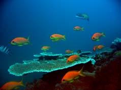
2 Africa Overview Africa has approximately km of coast across 32 mainland countries and four island states. Africa's coastal ecosystems are some of the most biologically productive in the world resulting from the unique physical, climatic and dynamic nature of the ecosystems. - African Environment Outlook, UNEP
3 African Marine Atlas links, partners and contributors GLOBAL NOAA CoML GEO/GOOS/GEOSS International Coastal Atlas Network USGS UNEP IOC/UNESCO GBIF OBIS AFRICAN AfrOBIS NEPAD ODINAFRICA GOOS-Africa ODINAFRICA Sea level data facility AMIS GeoNetCast-Africa ChloroGIN African Marine Atlas REGIONAL ReCoMap ASCLME SWIOFP SST WIO-LaB WIOMSA COI AMESD ACEP Clearing House Mechanism East Africa Regional Atlases Regional Project databases and products NATIONAL Universities Institutions NGOs National IOC coastal modelling projects Government departments State of the Environment reports National Oceanographic Data Centres Earth observation networks (SAEON) National Databases and products
4 African Coastal Atlas developments African-wide projects Coastal Atlas Projects in East and Southern Africa Coastal Atlas Projects in West and North Africa African Marine Atlas

5 African-wide projects Ocean Data and Information Network for Africa (ODINAFRICA), a project of IOC/UNESCO s IODE 1. Algeria 2. Angola 3. Benin 4. Cameroon 5. Comoros 6. Congo 7. Côte d'ivoire 8. Egypt 9. Gabon 10. Ghana 11. Guinea 12. Kenya 13. Madagascar 14. Mauritania 15. Mauritius 16. Morocco 17. Mozambique 18. Namibia 19. Nigeria 20. Senegal 21. Seychelles 22. South Africa 23. Tanzania 24. Togo 25. Tunisia Over 40 institutions in 25 countries National Oceanographic Data Centres (NODCs)

6 African-wide projects African Marine Atlas A project of ODINAFRICA

7 African-wide projects African Marine Information System AMIS

8 African-wide projects African Monitoring of the Environment for Sustainable Development AMESD
9 African-wide projects Large Marine Ecosystems Five Large Marine Ecosystems (GEF) Four LME Projects, 3 currently active Actively synthesizing and generating information to support the ecosystem approach. Canary Current LME
10 African-wide projects Large Marine Ecosystems Five Large Marine Ecosystems (GEF) Four LME Projects, 3 currently active Actively synthesizing and generating information to support the ecosystem approach. Guinea Current LME

11 African-wide projects Large Marine Ecosystems Five Large Marine Ecosystems (GEF) Four LME Projects, 3 currently active Actively synthesizing and generating information to support the ecosystem approach. Benguela Current LME

12 African-wide projects Large Marine Ecosystems Five Large Marine Ecosystems (GEF) Four LME Projects, 3 currently active Actively synthesizing and generating information to support the ecosystem approach. Agulhas Current LME
13 African-wide projects Large Marine Ecosystems Five Large Marine Ecosystems (GEF) Four LME Projects, 3 currently active Actively synthesizing and generating information to support the ecosystem approach. Somali Current LME
 http://afrobis.csir.")
14 African-wide projects Ocean Biogeographic Information System (AfrOBIS)
 African nodes -")
15 African-wide projects Global Biodiversity Information Facility (GBIF) African nodes - SABIF

16 African-wide projects New Partnership for Africa s Development NEPAD
 http://gridnairobi.unep.")
17 Coastal Atlas Projects in East and Southern Africa Nairobi Convention Clearinghouse Mechanism (NC CHM Project)


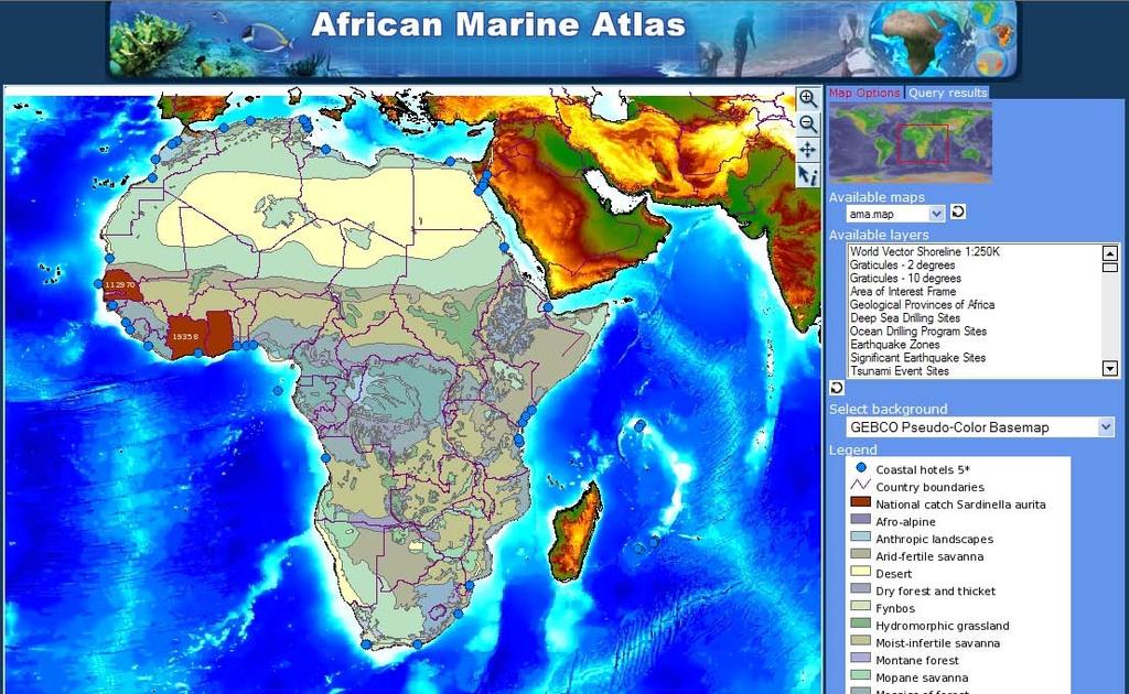
18 The African Marine Atlas
19 The African Marine Atlas A project of the: Ocean Data and Information Network For Africa (ODINAFRICA), a network of National Institutions in Africa funded by the: Government of Flanders and the: Intergovernmental Oceanographic Commission (IOC of UNESCO) s IODE
20 Ocean Data and Information Network for Africa (ODINAFRICA) 1. Algeria 2. Angola 3. Benin 4. Cameroon 5. Comoros 6. Congo 7. Côte d'ivoire 8. Egypt 9. Gabon 10. Ghana 11. Guinea 12. Kenya 13. Madagascar 14. Mauritania 15. Mauritius 16. Morocco 17. Mozambique 18. Namibia 19. Nigeria 20. Senegal 21. Seychelles 22. South Africa 23. Tanzania 24. Togo 25. Tunisia African Marine Atlas - participating NODCs Primary international partners: UNEP, ACEP
21 The African Marine Atlas A project designed to address the challenges: The coastal region & marine waters of Africa are biologically diverse, physically complex, and not well studied. Spatial data from past/published studies are not easily available. Coastal and marine management and decision-making is complex and requires easy access to reliable information. There is insufficient human capacity and data to meet management needs. There is a broad understanding of the usefulness of GIS and RS, but actual use is limited. There is limited access to public funded data. Global data resources are not easily accessible. Useful data products are urgently needed for natural resource management, coastal planning, and management of marine protected areas at a national and regional level.
22 The African Marine Atlas 1. Improve access to data (online Atlas product) The Project 2. Increase capacity to use data (training courses, work programmes) A project that aims to source, collect and format marine geospatial datasets and make them available to marine scientists and managers while building capacity for marine data management. The Products A digital GIS atlas, and atlas products, containing a broad spectrum of informative marine geo-information about the African coasts and oceans.

23 The African Marine Atlas Designing the project: 1. National level consultation and workshops (Jan June 2005) 2. Regional workshops, at which regional needs and products were identified and prioritised based on national consultative reports 3. Input from regional programmes 4. Annual ODINAFRICA Seminar
 Existing geo-referenced datasets available in the public domain (but tailored to meet specific user requirements).")
24 The African Marine Atlas Technical Scope: Five Themes: Geosphere, Hydrosphere, Atmosphere, Biosphere, Human environment The atlas incorporates data sets that are relevant in any way to coastal / marine sciences or management (initial list of over 200 data categories) Existing geo-referenced datasets available in the public domain (but tailored to meet specific user requirements). Continental Africa and island states: 40 N 30 W 80 E 50 S Transboundary data sets
 and the United Nations Environment Programme")
25 The African Marine Atlas The Team: ODINAFRICA National Data Centre Managers from 12 countries and two regional partners, the African Coelacanth Ecosystem Programme (ACEP) and the United Nations Environment Programme (UNEP)
26
27 Product 1: Static website (spatial data clearinghouse) Atlas Themes GEOSPHERE HYDROSPHERE ATMOSPHERE BIOSPHERE HUMAN ENVIRONMENT BASE MAP Individual Data Products
 Atlas Themes GEOSPHERE HYDROSPHERE ATMOSPHERE BIOSPHERE HUMAN ENVIRONMENT BASE MAP Individual Data Products 19 445 96 231 27 61 http://iodeweb2.vliz.")
28 Product 1: Static website (spatial data clearinghouse) >800 unique data sets, each one: described briefly JPG image provided of the data Link to source, citation Downloadable zip file: (actual data, data image and metadata in original form) Atlas Themes GEOSPHERE HYDROSPHERE ATMOSPHERE BIOSPHERE HUMAN ENVIRONMENT BASE MAP Individual Data Products

29 Product 2. African Marine Atlas WebMapServer Demonstration site developed Selection of themes Training and working meetings (2) Current display:
30
31
32 Challenges Expectations of an online data atlas Metadata management Standards: choosing data formats and standard legends Selecting appropriate data of interest and meaning at continental scale Logistics of working together from several countries Remote access to servers Access to the Internet from countries Biological data: specific permission had to be requested and recorded, data citations were complex Sustainability of the project

33 Short-term recommendations Linking of the static (clearinghouse) and dynamic (WMS) sites Editing of the WMS site Ordering layers by theme, in hierarchical drop-down lists Investigate the level of use of the Atlas by countries and NODCs and monitor this over time Produce technical and peer-reviewed publications
34 Considerations for the next phase (2009..) The African Marine Atlas is the largest online resource of multidisciplinary, downloadable spatial information for the African continent, and it has proved to be a valuable information resource in its current shape. There is considerable opportunity for the African Marine Atlas to develop further.. We have implemented a WMS, need a CSW and WFS. Alignment with other regional information systems (Nairobi Convention Clearinghouse Mechanism and LME systems) and international networks (International Coastal Atlas Network) is essential. We aim to adopt recommendations and best practices of ICAN.
35 The AMA must develop functionality at more scales (different management & research questions need data at appropriate scale) including National and case-study scale. Regional projects should be encouraged to use and contribute to the AMA process (design, training, data provision). LME Projects, for example, have a requirement to collect new data, to provide data management training and to develop data products. NODCs (as National data repositories) and the African Marine Atlas (as the continental portal to query the NODC resources) can provide an established framework for some of these activities. In the development of National and Continental systems within Africa, we have the opportunity to maximise harmonisation (now, through the adoption of consistent structures and ontologies) to minimise the need for mediation later.
36 The African Marine Atlas can grow to become an integrated coastal & marine information resource for Africa. It is itself a product, but it can be more than that, by providing a platform for the dissemination of other products and tools at all scales (regional, national, case study). Together with OceanTeacher, the AMA can provide material for training courses and derive new products which can go back into the atlas. Lessons learned and best-practice will be exchanged with other developing country Atlases (such as the Caribbean Marine Atlas CMA)
37 Acknowledgements IOC/UNESCO, UNEP, ACEP, ASCLME
The African Marine Atlas
 The African Marine Atlas International Coastal Atlas Network Workshop, Copenhagen, Denmark, 7 July 2008 The African Marine Atlas A project of the: Ocean Data and Information Network For Africa (ODINAFRICA),
The African Marine Atlas
 The African Marine Atlas ICAN 5 - Oostende, Belgium, 31 Aug - 2 Sep 2011 Mika Odido, Lucy Scott The African Marine Atlas A project of the: Ocean Data and Information Network For Africa (ODINAFRICA), funded
Linking Global and Regional Levels in the Management of Marine Areas Beyond National Jurisdiction
 Linking Global and Regional Levels in the Management of Marine Areas Beyond National Jurisdiction South Atlantic Region Session 4: «Experiences, Priorities and Opportunities in the South Atlantic and Indian
ACKNOWLEDGEMENTS. Contributions from: Prof. Larry Hildebrand. Dr. David Obura CORDIO - Kenya
 ACKNOWLEDGEMENTS Contributions from: Prof. Larry Hildebrand World Maritime University, Malmo, Sweden Dr. David Obura CORDIO - Kenya Ms. Sibongile Manzana-Saruchera GIZ MARISMA Project, Benguela Current
THE ROLE OF SEAMIC IN SUSTAINABLE MINERAL RESOURCES DEVELOPMENT IN AFRICA
 THE ROLE OF SEAMIC IN SUSTAINABLE MINERAL RESOURCES DEVELOPMENT IN AFRICA Ketema Tadesse Director General-SEAMIC Dar es Salaam, Tanzania August 11, 2009 SEAMIC BACKGROUND SEAMIC was established in 1977
Making a Mental Map of the Region
 Africa Preview Making a Mental Map of the Region Draw an outline map of Africa on the next page or on a separate sheet of paper. Add a compass rose to your map, showing where north, south, east, and west
Marine Science in the Agulhas and Somali Current Large Marine Ecosystems (ASCLME) Project
 Project") Marine Science in the Agulhas and Somali Current Large Marine Ecosystems (ASCLME) Project Lucy Scott Large Marine Ecosystems The Agulhas and Somali Current and Mascarene region are three Large Marine Ecosystems
Marine Science in the Agulhas and Somali Current Large Marine Ecosystems (ASCLME) Project Lucy Scott Large Marine Ecosystems The Agulhas and Somali Current and Mascarene region are three Large Marine Ecosystems
THE WASHINGTON COASTAL ATLAS
 THE ICAN COASTAL ATLAS MEDIATOR PROTOTYPE AND CONNECTING THE WASHINGTON COASTAL ATLAS Liz O Dea 1, Yassine Lassoued 2, Tanya Haddad 3, Declan Dunne 2 1 GIS Services Unit, WA State Dept. of Ecology 2 Coastal
African requirements for SDI standardization Antony Cooper Operating Unit Fellow Built Environment CSIR PO Box 395, Pretoria, 0001, South Africa
 ISO/TC 211 workshop on spatial data infrastructures (SDIs) African requirements for SDI standardization Antony Cooper Operating Unit Fellow Built Environment CSIR PO Box 395, Pretoria, 0001, South Africa
Capacity Development and ABNJ
 ABNJ Regional Leaders Program First Session Capacity Development and ABNJ Regional and National Perspectives Examples from Africa January 21, 2015 Conference Room 7, United Nations HQ New York, USA Outline
Current status of operations of SWIOCOF. François BONNARDOT Head of Climate Division Météo-France, Direction Interrégionale pour l Océan Indien
 Current status of operations of SWIOCOF François BONNARDOT Head of Climate Division Météo-France, Direction Interrégionale pour l Océan Indien WMO International Workshop on Global Review of Regional Climate
Strengthening the Southwestern indian ocean islands network
 Strengthening the Southwestern indian ocean islands network By Said Ahamada Assistant in charge of environment and fisheries said.ahamada@coi-ioc.org ICRI 29 th General Meeting in OKINAWA, October 2014
NSDI as a tool for Secure land tenure
 NSDI as a tool for Secure land tenure General Overview To look at the progress in SDI development and its application in policy formulation and impact on land tenure. INTEGRATION OF INFORMATION POLICIES
REPORT ON ACTIVITIES UNDERTAKEN SINCE THE 25TH SESSION OF THE INTERNATIONAL COORDINATING COUNCIL OF THE MAN & THE BIOSPHERE PROGRAMME
 AFRICAN NETWORK OF BIOSPHERE RESERVES (AFRIMAB) REPORT ON ACTIVITIES UNDERTAKEN SINCE THE 25TH SESSION OF THE INTERNATIONAL COORDINATING COUNCIL OF THE MAN & THE BIOSPHERE PROGRAMME 26 TH MAB ICC SESSION
Areas Beyond National Jurisdiction (ABNJ) 2016 Regional Leaders Program. March 22 to April 1, 2016 United Nations, New York
 2016 Regional Leaders Program. March 22 to April 1, 2016 United Nations, New York") Areas Beyond National Jurisdiction (ABNJ) 2016 Regional Leaders Program March 22 to April 1, 2016 United Nations, New York Welcome and Introductions Biliana Cicin-Sain President, Global Ocean Forum Vladimir
Areas Beyond National Jurisdiction (ABNJ) 2016 Regional Leaders Program March 22 to April 1, 2016 United Nations, New York Welcome and Introductions Biliana Cicin-Sain President, Global Ocean Forum Vladimir
- West Africa. Abuja, Nigeria May Fredericton Canada Heeswijk The Netherlands Washington DC United States Adelaide Australia
 A Case Study in Land and Sea Data Interoperability Patricia GASPAR(Netherlands), Andrew HOGGARTH(Canade), Gordon JOHNSTON(UK), Charles de JONG(Netherlands) - West Africa Abuja, Nigeria - 6-10 May 2013
SHaSA. Strategy for the Harmonization of Statistics in Africa
 BANQUE AFRICAINE DE DEVELOPPEMENT AFRICAN DEVELOPMENT FUND Strategy for the Harmonization of Statistics in Africa Strategy for the Harmonization of Statistics in Africa 2017-2026 SHaSA Multi-Year Action
RCOF Review [Regional Climate Outlook Forum for the Gulf of Guinea region of Africa - PRESAGG] Status Report
![RCOF Review [Regional Climate Outlook Forum for the Gulf of Guinea region of Africa - PRESAGG] Status Report](/thumbs/78/77466191.jpg "RCOF Review [Regional Climate Outlook Forum for the Gulf of Guinea region of Africa - PRESAGG] Status Report") RCOF Review 2017 [Regional Climate Outlook Forum for the Gulf of Guinea region of Africa - PRESAGG] Status Report Specific Climate features of concerned region This region typically covers the area below
RCOF Review 2017 [Regional Climate Outlook Forum for the Gulf of Guinea region of Africa - PRESAGG] Status Report Specific Climate features of concerned region This region typically covers the area below
13 th EUMETSAT User Forum in Africa
 13 th EUMETSAT User Forum in Africa GMES & Africa implementation in Western Africa Dogbeda M.Y. Azumah Regional Marine Centre University of Ghana Pictures zone UG GMES Presentation Layout UG G Project
Charles Magori. Status Report of GLOSS Tide Gauges in Kenya
 GLOSS Group of Experts Meeting February 2005 Charles Magori Introduction Status Report of GLOSS Tide Gauges in Kenya There is growing concern about the rise in mean sea level around the globe. To address
A contribution to GEOSS from the SDI for Georesources in Africa
 A contribution to GEOSS from the SDI for Georesources in Africa A. TELLEZ-ARENAS BRGM, France in behalf of: Dr. Marc URVOIS Project Coordinator BRGM, France Mineral Resources Division INSPIRE Conference
SECOND GENERATION SEASONAL CLIMATE OUTLOOK PROGRAMME
 Page 1/5 CENTRE AFRICAIN POUR LES APPLICATIONS DE LA METEOROLOGIE AU DEVELOPPEMENT AFRICAN CENTRE OF METEOROLOGICAL APPLICATIONS FOR DEVELOPMENT Institution Africaine parrainée par la CEA et l OMM African
1. CLIMATIC AND ENVIRONMENTAL CONDITIONS OVER AFRICA. 1.1 Inter-Tropical Discontinuity (ITD)
") African Centre of Meteorological Application for Development Centre Africain pour les Applications de la Météorologie au Développement OCTOBER 2011 HIGHLIGHT: Cholera, Acute Water Diarrhoea, Yellow fever,
African Centre of Meteorological Application for Development Centre Africain pour les Applications de la Météorologie au Développement OCTOBER 2011 HIGHLIGHT: Cholera, Acute Water Diarrhoea, Yellow fever,
RCOF Review 2017 SWIOCOF. Status Report (Survey) Annotated Outline
 Annotated Outline") RCOF Review 2017 SWIOCOF Status Report (Survey) Annotated Outline Specific Climate features of concerned region The South West Indian Ocean (SWIO) region refers to the Indian Ocean islands states and coastal
RCOF Review 2017 SWIOCOF Status Report (Survey) Annotated Outline Specific Climate features of concerned region The South West Indian Ocean (SWIO) region refers to the Indian Ocean islands states and coastal
AAG Partnerships for. Sustainable Development in Africa: Geospatial Science & Technology for. Partnerships and Applications
 AAG Partnerships for Sustainable Development in Africa Geospatial Science & Technology for Sustainable Development in Africa: Partnerships and Applications Harvard University John F. Kennedy School of
Activity 6.3 Geoscience information infrastructure and management
 G E O S C I E N T I F I C K N O W L E D G E A N D S K I L L S I N A F R I C A N G E O L O G I C A L S U R V E Y S Activity 6.3 Geoscience information infrastructure and management CAG25 - TW4 Workshop
UNESCO s Earth Science. Education Initiative in Africa. United Nations Educational, Scientific and Cultural Organization
 UNESCO s Earth Science Education Initiative in Africa United Nations Educational, Scientific and Cultural Organization Few milestones First International Conference on African and Arabian Geoparks 2011,
a division of Teacher Created Materials
 Sample Pages from a division of Teacher Created Materials Thanks for checking us out. Please call us at 877-777-3450 with questions or feedback, or to order this product. You can also order this product
Developing Spatial Data Infrastructure (SDI) in Africa: A cooperative Geospatial information Management process
 in Africa: A cooperative Geospatial information Management process") IAMOSA Geneva 16-18 March 2011 Developing Spatial Data Infrastructure (SDI) in Africa: A cooperative Geospatial information Management process United Nations Economic Commission for Africa ICT and Sciences
IAMOSA Geneva 16-18 March 2011 Developing Spatial Data Infrastructure (SDI) in Africa: A cooperative Geospatial information Management process United Nations Economic Commission for Africa ICT and Sciences
INDEX REPORT MO IBRAHIM FOUNDATION
 2017 IBRAHIM INDEX OF AFRICAN GOVERNANCE INDEX REPORT MO IBRAHIM FOUNDATION 2017 IBRAHIM INDEX OF AFRICAN GOVERNANCE INDEX REPORT MO IBRAHIM FOUNDATION Contents General overview Framework of the 2017
GMES and AFRICA Support Programme 1st technical committee meeting
 GMES and AFRICA Support Programme 1st technical committee meeting Developing an Earth Observation Operational Application for Coastal Ecosystems Mapping, Monitoring and Assessment of the Northern African
Ocean Data and Information Network for Africa (ODINAFRICA)
") Limited distribution IOC/IODE-XIX/35 22 February 2007. Original: English INTERGOVERNMENTAL OCEANOGRAPHIC COMISSION (of UNESCO) Nineteenth Session of the IOC Committee on International Oceanographic Data
Limited distribution IOC/IODE-XIX/35 22 February 2007. Original: English INTERGOVERNMENTAL OCEANOGRAPHIC COMISSION (of UNESCO) Nineteenth Session of the IOC Committee on International Oceanographic Data
Stratigraphic Harmonization in West Africa, a multi-country exploration project. Tim Gibbons Manager of Business Development 5 th March 2015
 Stratigraphic Harmonization in West Africa, a multi-country exploration project Tim Gibbons Manager of Business Development 5 th March 2015 I saw a crane outside What if we call the same thing by a different
EABRN, 20 years of History and its Future (East Asia Biosphere Reserve Network)
") EABRN, 20 years of History and its Future (East Asia Biosphere Reserve Network) Choi Jongwon Director, MoE, Republic of Korea Contents 1 Overview and History 2 Key Activities (1) Regional Network Meetings
EABRN, 20 years of History and its Future (East Asia Biosphere Reserve Network) Choi Jongwon Director, MoE, Republic of Korea Contents 1 Overview and History 2 Key Activities (1) Regional Network Meetings
PTV Africa City Map 2017 (Standardmap)
") PTV Africa City Map 2017 (Standardmap) Map version name (Core) Map version name (Logistic) Release date (Logistics) Map version name (Logistics) (new) PTV_Africa_City_Map_2017 Data provider(s) Technology
PTV Africa City Map 2017 (Standardmap) Map version name (Core) Map version name (Logistic) Release date (Logistics) Map version name (Logistics) (new) PTV_Africa_City_Map_2017 Data provider(s) Technology
Proper Data Management Responsibilities to Meet the Global Ocean Observing System (GOOS) Requirements
 Requirements") Data Buoy Cooperation Panel XXVI Oban, Scotland, UK 27 September 2010 Proper Data Management Responsibilities to Meet the Global Ocean Observing System (GOOS) Requirements William Burnett Data Management
Data Buoy Cooperation Panel XXVI Oban, Scotland, UK 27 September 2010 Proper Data Management Responsibilities to Meet the Global Ocean Observing System (GOOS) Requirements William Burnett Data Management
Blue Economy and Marine Spatial Planning in the Western Indian Ocean
 Blue Economy and Marine Spatial Planning in the Western Indian Ocean Louis Celliers RD&I: Ocean and Coastal Governance CSIR Coastal Systems Marine Spatial Planning and Area-based Planning Tools Workshop
Global Environment Facility - Integrating Watershed & Coastal Areas Management (GEF-IWCAM): Andros Demonstration Site
: Andros Demonstration Site") Global Environment Facility - Integrating Watershed & Coastal Areas Management (GEF-IWCAM): Andros Demonstration Site Coastal Aquifer Management in Small Island Developing States of the Caribbean: Challenges
Global Environment Facility - Integrating Watershed & Coastal Areas Management (GEF-IWCAM): Andros Demonstration Site Coastal Aquifer Management in Small Island Developing States of the Caribbean: Challenges
the map Redrawing Donald Hobern takes a look at the challenges of managing biodiversity data [ Feature ]
![the map Redrawing Donald Hobern takes a look at the challenges of managing biodiversity data [ Feature ]](/thumbs/82/86628837.jpg "the map Redrawing Donald Hobern takes a look at the challenges of managing biodiversity data [ Feature ]") Redrawing the map Donald Hobern takes a look at the challenges of managing biodiversity data 46 Volume 12 > Number 9 > 2008 www.asiabiotech.com Cicadetta sp., Canberra, Australia, December 2007 Photograph
Redrawing the map Donald Hobern takes a look at the challenges of managing biodiversity data 46 Volume 12 > Number 9 > 2008 www.asiabiotech.com Cicadetta sp., Canberra, Australia, December 2007 Photograph
OUR COASTAL FUTURES. A Strategy for the Sustainable Development of the World s Coasts.
 OUR COASTAL FUTURES A Strategy for the Sustainable Development of the World s Coasts www.futureearthcoasts.org Iqaluit, Nunavut, Canada. Photo by Don Forbes Coastal zones are the frontline in our global
The Research Agenda of the Wisconsin Coastal Atlas
 The Research Agenda of the Wisconsin Coastal Atlas David Hart GIS Specialist University of Wisconsin Sea Grant Institute International Coastal Atlas Network Workshop 4 Trieste, Italy Tuesday, November
GINA Children. II Global Index for humanitarian Needs Assessment (GINA 2004) Sheet N V V VI VIII IX X XI XII XII HDR2003 HDR 2003 UNDP
 Sheet N V V VI VIII IX X XI XII XII HDR2003 HDR 2003 UNDP") Human UNICEF Index Index Natural 2003 GDP per Total as % of Total Rate HDI HPI Disasters Conflicts capita Population population 5 1 Congo, Democratic Republic of the 2,80000 3 3 1 3 3 3 3 3 3 3 2 Burundi
Human UNICEF Index Index Natural 2003 GDP per Total as % of Total Rate HDI HPI Disasters Conflicts capita Population population 5 1 Congo, Democratic Republic of the 2,80000 3 3 1 3 3 3 3 3 3 3 2 Burundi
Introducing the. a partnership of
 Introducing the a partnership of Background Need for online atlas identified by managers and researchers to make coastal data available Shoreline data Ocean and coastal resources Sea-level rise potential
THE SEVILLE STRATEGY ON BIOSPHERE RESERVES
 THE SEVILLE STRATEGY ON BIOSPHERE RESERVES 1 VISION FOR BIOSPHERE RESERVES IN THE 21 ST CENTURY The international Seville Conference on Biosphere Reserves, organised by UNESCO, adopted a two-pronged approach,
Understanding riverine wetland-catchment processes using remote sensing data and modelling
 Understanding riverine wetland-catchment processes using remote sensing data and modelling Yunqing Xuan (UNESCO-IHE, NL) Didier Haguma (KIST, Rwanda) William Niyonzima (UNESCO-IHE, NL) Ann van Griensven
7 th WMO RAI Dissemination Expert working Group RAIDEG report. Mariane Diop Kane, Chair
 7 th WMO RAI Dissemination Expert working Group RAIDEG report Mariane Diop Kane, Chair Overview Established in 2010 by WMO, in cooperation with EUMETSAT Endorsed by WMO RA-I at its 16 th session in 2015,
Fundamental Geospatial Datasets in Africa. Andre Nonguierma New York, 03 August 2015
 Fundamental Geospatial Datasets in Africa United Nations Economic Commission for Africa Geoinformation & Spatial Statistics Andre Nonguierma New York, 03 August 2015 Core Data : Lack of consistency Infrastructure
Spatial Data Infrastructure Concepts and Components. Douglas Nebert U.S. Federal Geographic Data Committee Secretariat
 Spatial Data Infrastructure Concepts and Components Douglas Nebert U.S. Federal Geographic Data Committee Secretariat August 2009 What is a Spatial Data Infrastructure (SDI)? The SDI provides a basis for
PTV Africa City Map (Standardmap)
") PTV Africa City Map 2018.2 (Standardmap) Map version name (Core) Map version name (Logistic) Release date (Logistics) Map version name (Logistics) (new) PTV_Africa_City_Map_2018.2 Data provider(s) Technology
PTV Africa City Map 2018.2 (Standardmap) Map version name (Core) Map version name (Logistic) Release date (Logistics) Map version name (Logistics) (new) PTV_Africa_City_Map_2018.2 Data provider(s) Technology
UNESCO Earth Science Education Initiative in Africa Initial Activities
 UNESCO Earth Science Education Initiative in Africa Initial Activities S. Felix Toteu 1 and Sarah Gaines 2 1 UNESCO Nairobi Office, Kenya 2 UNESCO Headquarters, Paris In Arusha, Tanzania on 8 May 2008
Weather Climate Science to Service Partnership South Africa
 PROJECTS UNDERWAY Title of the Weather Climate Science to Service Partnership South Africa Together, building on an existing strong partnership, South African Weather Service and the Met Office will build
Masters in «Biology» at the ULB
 Education 1 Organism Biology The ULB organizes three masters in biology or closely linked with biology: Master in Organism Biology and Ecology Specialisations: Didactique: Didactics/education Approfondie:
The International Indian Ocean Expedition. Mika ODIDO IOC Sub Commission for Africa and the Adjacent Island States
 The International Indian Ocean Expedition Mika ODIDO IOC Sub Commission for Africa and the Adjacent Island States INDIAN OCEAN Facts and Figures 3rd largest ocean (after Pacific and Atlantic) Extent from
The FAO Africover Project and a Possibility of a Unified Geodetic Datum for Africa (UGDA)
") Distr.: LIMITED ECAlNRD/CART.9/0RG.30 Add. 1 October 1996 Original: ENGLISH \ Ninth United Nations Regional Cartographic Conference for Africa Addis Ababa, Ethiopia 11-15 November 1996 The FAO Africover
Distr.: LIMITED ECAlNRD/CART.9/0RG.30 Add. 1 October 1996 Original: ENGLISH \ Ninth United Nations Regional Cartographic Conference for Africa Addis Ababa, Ethiopia 11-15 November 1996 The FAO Africover
Table ronde 5 : Cartographie d'urgence Emergency Mapping.
 Table ronde 5 : Cartographie d'urgence Emergency Mapping MapAction is an international NGO that provides maps and other information services to help humanitarian relief organisations in the field MapAction
FOURTH INTERNATIONAL PORT METEOROLOGICAL OFFICERS WORKSHOP AND SUPPORT TO GLOBAL OCEAN OBSERVATIONS USING SHIP LOGISTICS
 FOURTH INTERNATIONAL PORT METEOROLOGICAL OFFICERS WORKSHOP AND SUPPORT TO GLOBAL OCEAN OBSERVATIONS USING SHIP LOGISTICS PMO-IV 8-10 DEC 2010, ORLANDO, FLORIDA, USA 1 This presentation is generally for
Future perspectives for EO in Development
 Future perspectives for EO in Development Meeting at ESA/ESRIN in Frascati 11 th of September 2018 #WorldInCommon AGENCE FRANÇAISE DE DÉVELOPPEMENT FRENCH DEVELOPMENT AGENCY 01. What is AFD? France s international
Rising from the Depths Utilising Marine Cultural Heritage in East Africa to help develop sustainable social, economic and cultural benefits
 KENYA MEETING, 23 rd FEBRUARY 2018 1 Rising from the Depths Utilising Marine Cultural Heritage in East Africa to help develop sustainable social, economic and cultural benefits 1. Introduction The Rising
GIS at UCAR. The evolution of NCAR s GIS Initiative. Olga Wilhelmi ESIG-NCAR Unidata Workshop 24 June, 2003
 GIS at UCAR The evolution of NCAR s GIS Initiative Olga Wilhelmi ESIG-NCAR Unidata Workshop 24 June, 2003 Why GIS? z z z z More questions about various climatological, meteorological, hydrological and
AND REGIONAL PROJECTS
 NAIROBI CONVENTION: The Convention for the Protection, Management and Development of the Marine and Coastal Environment of the Western Indian Ocean Nairobi Convention a) Legal framework that has mandate
Supplementary Appendix for. Version: February 3, 2014
 Supplementary Appendix for When Do Governments Resort to Election Violence? Version: February 3, 2014 This appendix provides supplementary information not included in the published draft. Supplementary
Applied Geoscience and Technology Division SOPAC. Joy Papao, Risk Information Systems Officer
 Joy Papao, Risk Information Systems Officer Secretariat of the Pacific Community SPC 22 Pacific Island States Head office in Noumea, New Caledonia 2 Regional offices (Pohnpei and Honiara) 600 staff 9 Technical
ICZM and MSP in the Black Sea Region
 ICZM and MSP in the Black Sea Region Drd. Claudia Coman, Environmental engineer AG ICZM Focal Point, Romania Black Sea Commission Black Sea Commission on the Protection of the Black Sea against Pollution
Building capacity to support decisionmaking for protection and management of marine areas
 Credit_Deep Atlantic Stepping Stones Science Team_IFE_URI_NOAA_no3 Credit: John Weller, john@lastocean.com Credit: John Weller, john@lastocean.com Credit: John Weller, john@lastocean.com Credit: Sarah
Early Warning > Early Action: The Next Frontier. Dr. Arame Tall Climate Services- Global Coordinator, Champion
 Early Warning > Early Action: The Next Frontier Dr. Arame Tall Climate Services- Global Coordinator, Champion a.tall@cgiar.org 2 3/21/11 The Challenge: Bridging The Gap Seasonal Precipitation Forecast
The Effect of Sea Access on Economic Income Level in African Nations
 University of Nebraska - Lincoln DigitalCommons@University of Nebraska - Lincoln Nebraska Anthropologist Anthropology, Department of 2011 The Effect of Sea Access on Economic Income Level in African Nations
GBIF Global Biodiversity Information Facility. Dmitry Schigel, Tim Hirsch Arctic data and Global Biodiversity Information Facility
 GBIF Global Biodiversity Information Facility Dmitry Schigel, Tim Hirsch Arctic data and Global Biodiversity Information Facility WHAT IS GBIF? Intergovernmental collaboration founded in 2001 on the recommendation
Regional Centre for Mapping of Resources for Development (RCMRD), Nairobi, Kenya
, Nairobi, Kenya") Regional Centre for Mapping of Resources for Development (RCMRD), Nairobi, Kenya Introduction GIS ( 2 weeks: 10 days) Intakes: 7 th Jan, 4 th Feb,4 th March, 1 st April 6 th May, 3 rd June, 1 st July,
Regional Centre for Mapping of Resources for Development (RCMRD), Nairobi, Kenya Introduction GIS ( 2 weeks: 10 days) Intakes: 7 th Jan, 4 th Feb,4 th March, 1 st April 6 th May, 3 rd June, 1 st July,
Cambridge International Examinations Cambridge Ordinary Level
 Cambridge International Examinations Cambridge Ordinary Level *2207173583* GEOGRAPHY 2217/13 Paper 1 May/June 2017 Candidates answer on the Question Paper. Additional Materials: Calculator Ruler 1 hour
Antarctic Marine Biodiversity Data Now Online
 Contact: Bruno Danis +32(2)6274139 bruno.danis@scarmarbin.be EMBARGOED UNTIL 9 a.m ECT, March 31 2009 Antarctic Marine Biodiversity Data Now Online An efficient network of specialists, data and tools to
Launch of the Atlas and workshop on Land Use Land Cover
 The formal opening ceremony of the meeting took place on Tuesday 11 July 2017 and was chaired by Mrs. Fanta C. Kafando, Director of Environmental Preservation representing the Minister of the Environment
Scaling Seed Kits Through Household Gardens
 Scaling Seed Kits Through Household Gardens SENEGAL WESTERN SAHARA LIBERIA PORTUGAL REPULIC OF IRELAND COTE D IVOIRE UNITED KINGDOM GHANA NETHERLANDS BELGIUM DENMARK SWITZ. TUNISIA CAMEROON CZECH REPUBLIC
OCEANOGRAPHIC DATA MANAGEMENT
 OCEANOGRAPHIC DATA MANAGEMENT Presented to: Environmental Disaster Data Management Meeting Russ Beard Director, National Coastal Data Development Center Interim Science Coordinator, Gulf Restoration Council
Regional Centre for Mapping of Resources for Development (RCMRD), Nairobi, Kenya. Introduction GIS ( 2 weeks: 10 days)
, Nairobi, Kenya. Introduction GIS ( 2 weeks: 10 days)") Regional Centre for Mapping of Resources for Development (RCMRD), Nairobi, Kenya Introduction GIS ( 2 weeks: 10 days) Intakes: 8 th Jan, 6 th Feb,5 th March, 3 rd April 9 th, May 7 th, June 4 th, July
Regional Centre for Mapping of Resources for Development (RCMRD), Nairobi, Kenya Introduction GIS ( 2 weeks: 10 days) Intakes: 8 th Jan, 6 th Feb,5 th March, 3 rd April 9 th, May 7 th, June 4 th, July
Land Use / Land Cover Mapping in
 Land Use / Land Cover Mapping in Eastern and Southern African Regions RCMRD Experience by 6/24/2013, Nairobi Kenya Dr. Tesfaye Korme Director of RS, GIS and Mapping, RCMRD I. About RCMRD, Its Vision and
THEME: Seasonal forecast: Climate Service for better management of risks and opportunities
 CENTRE AFRICAIN POUR LES APPLICATIONS DE LA METEOROLOGIE AU DEVELOPPEMENT AFRICAN CENTRE OF METEOROLOGICAL APPLICATIONS FOR DEVELOPMENT Institution Africaine parrainée par la CEA et l OMM African Institution
Evaluating Sustainability of the Georesources Observation System
 Evaluating Sustainability of the Georesources Observation System Michael Mente Federal Institute for Geosciences and Natural Resources Germany, Hannover GEOSS-CBC Meeting Athens April 27th 28th, 2009 GEOSS-CBC
North-South Gap Mapping Assignment Country Classification / Statistical Analysis
 North-South Gap Mapping Assignment Country Classification / Statistical Analysis Due Date: (Total Value: 55 points) Name: Date: Learning Outcomes: By successfully completing this assignment, you will be
ACTION PLAN FOR WORLD HERITAGE IN LATIN AMERICA AND THE CARIBBEAN ( )
") Annex ACTION PLAN FOR WORLD HERITAGE IN LATIN AMERICA AND THE CARIBBEAN (2014-2024) The current Regional Action Plan for Latin America and the Caribbean for 2014-2024 has been elaborated by the State Parties
Annex ACTION PLAN FOR WORLD HERITAGE IN LATIN AMERICA AND THE CARIBBEAN (2014-2024) The current Regional Action Plan for Latin America and the Caribbean for 2014-2024 has been elaborated by the State Parties
Mapping African buffalo distributions, in relation to livestock disease risk
 Mapping African buffalo distributions, in relation to livestock disease risk Tim Robinson and Jennifer Siembieda Buffalo Mapping Meeting 7-8 June, Rome FAO, Canada Room Overview Modelling densities of
Call for Applications
 Call for Applications for a PanAfGeo Training «WP7 Geoscientific information Management» 20 November - 1 st December 2017 Accra, Ghana in English 1. MAIN CONTEXT OF PANAFGEO PanAfGeo for Pan-African Support
WASA Project Team. 13 March 2012, Cape Town, South Africa
 Overview of Wind Atlas for South Africa (WASA) project WASA Project Team 13 March 2012, Cape Town, South Africa Outline The WASA Project Team The First Verified Numerical Wind Atlas for South Africa The
ACRONYMS AREAS COUNTRIES MARINE TERMS
 Natura 2000 ACRONYMS AREAS COUNTRIES MARINE TERMS DEFINITION A European network of protected sites under the European Habitats and Birds Directives, aiming to protect the most valuable and threatened European
Ocean Colour 2009 Africa, October 2009, Zanzibar, Tanzania
 Ocean Colour 2009 Africa, 12-23 October 2009, Zanzibar, Tanzania Following a successful 1 st training event in Mombasa (Kenya, 2007), the Global Environment Monitoring Unit (GEM) of the Institute for Environment
Step-by-step: Data Harmonisation Process
 Step-by-step: Data Harmonisation Process Anja Neundorf (University of Nottingham) 1 Rosalind Shorrocks (University of Manchester) 1 September 2017 Part of the ESRC-funded project Legacies of Authoritarian
Regional Centre for Mapping of Resources for Development (RCMRD), Nairobi, Kenya. Introduction GIS (2 weeks: 10 days)
, Nairobi, Kenya. Introduction GIS (2 weeks: 10 days)") Regional Centre for Mapping of Resources for Development (RCMRD), Nairobi, Kenya Introduction GIS (: 10 days) Intake Dates: 9 th Jan, 6 th Feb, 6 th Mar, 3 rd April, 8 th May, 5 th June, 3 rd July, 2017
Regional Centre for Mapping of Resources for Development (RCMRD), Nairobi, Kenya Introduction GIS (: 10 days) Intake Dates: 9 th Jan, 6 th Feb, 6 th Mar, 3 rd April, 8 th May, 5 th June, 3 rd July, 2017
Oceanology International, London, March 2012 Ocean Observation & Forecasting programme. An African Network of Offshore Real-Time Metocean Stations
 Oceanology International, London, March 2012 Ocean Observation & Forecasting programme An African Network of Offshore Real-Time Metocean Stations Valérie QUINIOU-RAMUS, Rémi ESTIVAL (TOTAL S.A., EP/DEV/TEC/GEO)
Establishment of a Common and Modern African Geodetic Reference System (Afref)
") Establishment of a Common and Modern African Geodetic Reference System (Afref) SUMMARY There are almost as many geodetic reference systems in African as there are countries. Sharing of data as is envisaged
Establishment of a Common and Modern African Geodetic Reference System (Afref) SUMMARY There are almost as many geodetic reference systems in African as there are countries. Sharing of data as is envisaged
Northwestern Hawaiian Islands Coral Reef Research Partnership: Ocean Mapping, Ecosystem Threats, and Information Management
 Northwestern Hawaiian Islands Coral Reef Research Partnership: Ocean Mapping, Ecosystem Threats, and Information Management Malia Chow Papahanaumokuakea Marine National Monument National Oceanic and Atmospheric
Appendix - Legal Origins and Female HIV
 Appendix - Legal Origins and Female HIV Siwan Anderson Vancouver School of Economics and CIFAR December 2017 A1. Figures Figure A1 Population Density (people/square km) by Ethnic Group 1 A2. Data Sources
an accessible interface to marine environmental data Russell Moffitt
 an accessible interface to marine environmental data Russell Moffitt The Atlas Project GOAL: To provide a single point of access to oceanographic and environmental data for use by marine resource researchers,
Empowered lives. Resilient nations. Data for People and Planet. powered by
 Empowered lives. Resilient nations. Data for People and Planet powered by Overview As we enter the fourth industrial revolution, technology is revolutionizing our ability to map nature. Satellite data
The future of SDIs. Ian Masser
 The future of SDIs Ian Masser Presentation Considers two questions relating to the future development of SDIs throughout the world Where have we got to now? Where should we go from here? Identifies four
Introduction of the Asia-Oceania Global Earth Observation System of Systems (AOGEOSS) GEO Initiative(GI-22 )
 GEO Initiative(GI-22 )") Introduction of the Asia-Oceania Global Earth Observation System of Systems (AOGEOSS) GEO Initiative(GI-22 ) Prof. Xiang ZHOU Institute of Remote Sensing and Digital Earth, CAS 11 May 2017 Kunming, China
Introduction of the Asia-Oceania Global Earth Observation System of Systems (AOGEOSS) GEO Initiative(GI-22 ) Prof. Xiang ZHOU Institute of Remote Sensing and Digital Earth, CAS 11 May 2017 Kunming, China
Contribution by. The Republic of South Africa. Innovation and Technology Development from Africa Astronomy
 THE UNITED NATIONS COMMISSION ON SCIENCE AND TECHNOLOGY FOR DEVELOPMENT 14 TH SESSION 23-27 May 2011 Geneva Contribution by The Republic of South Africa Innovation and Technology Development from Africa
PRIORITY TWO-YEAR ACTIVITIES ( ) PRIORITY ONE: INTERNATIONAL RECOGNITION OF ECOLOGICAL IMPORTANCE
 PRIORITY ONE: INTERNATIONAL RECOGNITION OF ECOLOGICAL IMPORTANCE") PREFACE: The Work Programme goals and priority activities were developed at the Second Joint Meeting of the Signatories to the Hamilton Declaration and the Sargasso Sea Commission, held in Key West Florida,
PREFACE: The Work Programme goals and priority activities were developed at the Second Joint Meeting of the Signatories to the Hamilton Declaration and the Sargasso Sea Commission, held in Key West Florida,
Black Sea Data Access services
 Black Sea Data Access services PERSEUS Oceanographic Mediterranean and Black Sea Data Management Cast Data Base with vertical profiles of physical, chemical and biological data acquired with Bottle casts
2007 / 2008 GeoNOVA Secretariat Annual Report
 2007 / 2008 GeoNOVA Secretariat Annual Report Prepared for: Assistant Deputy Minister and Deputy Minister of Service Nova Scotia and Municipal Relations BACKGROUND This report reflects GeoNOVA s ongoing
Current experiences in the use of satellite information in development aid activities
 Current experiences in the use of satellite information in development aid activities Meeting at ESA/ESRIN in Frascati 16 th of September 2017 #WorldInCommon AGENCE FRANÇAISE DE DÉVELOPPEMENT FRENCH DEVELOPMENT
PRECIS: Facilitating capacity building and climate vulnerability studies and applications in Africa
 PRECIS: Facilitating capacity building and climate vulnerability studies and applications in Africa Richard Jones Presentation to Met Africa group, Reading University 15.10.2007 Crown copyright Page 1