GBIF Global Biodiversity Information Facility. Dmitry Schigel, Tim Hirsch Arctic data and Global Biodiversity Information Facility
|
|
|
- Daniel Watkins
- 5 years ago
- Views:
Transcription


1 GBIF Global Biodiversity Information Facility Dmitry Schigel, Tim Hirsch Arctic data and Global Biodiversity Information Facility
2 WHAT IS GBIF? Intergovernmental collaboration founded in 2001 on the recommendation of OECD science panel Promotes and facilitates free and open access to biodiversity data via the internet Sustains a network that includes 52 participating countries & 40 organizations Secretariat based in Copenhagen operates global registry and GBIF.org
3 WHAT DOES GBIF DO? Promotes common standards and free tools for biodiversity data management and exchange Maintains global open access and web services to species data through GBIF.org Provides guidance on setting up national biodiversity information facilities and portals Supports and maintains collaborative network at global and regional levels

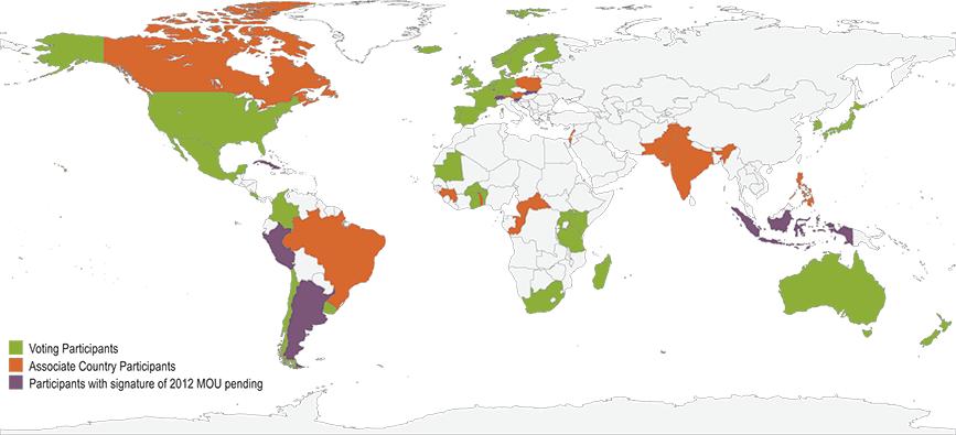
4 GBIF COUNTRY PARTICIPANTS


5 GBIF BY THE NUMBERS 517,957,421 species occurrence records 1,454,694 species 13,829 datasets 642 data-publishing institutions 18 NOV 2014


6 TYPES OF DATA SHARED THROUGH GBIF Specimens from museum and herbarium collections Observations from field surveys, inventories and citizen scientists Records extracted from literature
7 GBIF NATIONAL NODES

8 DATA REPATRIATION

9 RICHER RECORD DETAILS

10 RICHER RECORD DETAILS

 www.gbif.")
11 GBIF AND ARCTIC DATA Map by Nabil Youdjou, 2014 Antarc1c Biodiversity Informa1on System (AntaBIF/AntaBIS) Project at Royal Belgian Ins1tute of Natural Sciences(RBINS)


12 GBIF AND ARCTIC DATA


13 GBIF AND ABDS: DATA TYPES & COLLABORATION Anser CAFF <- > GBIF XLS XLS XLS DOC KML
 EBVs serve as intermediate layer between raw data and indicators (e.g.")
14 data standards Enabling discovery and access to sample-based data Working with EU BON partners, GBIF is adapting its IPT (Integrated Publishing Toolkit) and Darwin Core Archives to enable the flow of sample-based data Modifications will support GEO BON s Essential Biodiversity Variables (EBVs) EBVs serve as intermediate layer between raw data and indicators (e.g., for CBD) Support detection of changes and trends in populations Sample- based data quan&ta&ve calibrated comparable collected using standard protocols Photo CC BY-NC 2014, Guana Tolomato Matanzas National Estuarine Research Reserve:


15 GBIF AND REFERENCE DATASETS GBIF download Cleaned data Paper Download DOI Dataset DOI Paper DOI Researcher Data Data atribu1on User cleans data Data Data atribu1on User publishes paper Published paper can give resolvable links to GBIF download and/ or to cleaned dataset User searches for data through GBIF.org User deposits cleaned dataset in a repository and gets DOI for dataset GBIF.org Download history Download 1... GBIF.org creates a download data set GBIF assigns DOIs to data downloads DataCite Denmark


16 GBIF AND DATA PAPERS Scholarly publication of searchable metadata through Pensoft & Nature Publishing Describes a dataset or group of datasets in structured, human-readable form Promotes and publicizes the existence of data Provides scholarly credit to data publishers through citable journal publications

17 innovation GBIF Ebbe Nielsen Challenge Prize honouring a principal founders of GBIF reimagined as incentive competition Open call for innovative uses of GBIF-mediated biodiversity data Registration opened 2 Dec 14 Submissions due 2 March 15 #gbifchallenge
")
18 GBIF IMPACTS: SUPPORTING SCIENCE 300 GBIF discussed 250 GBIF- mediated data used No. of peer- reviewed publica1ons (Jan- Sept)
19 Take home data standards aggregate and share use data fitness for use cite correctly archive processed data gbif.org
20 Thank you gbif.org


21 human health Modelled environmental niches of three bat species associated with Ebola transmission Occurrence records accessed via GBIF At-risk areas cover 22 countries, population of 22 million Helps to prioritize surveillance and diagnostic capacity in at-risk areas DOI: /eLife Photo: Hypsignathus monstrusus, CC BY-NC Jakob Fahr, via inaturalist.org
 Modelled likely invasion success for South Africa based")

22 invasive alien species Used more than 20m records via GBIF for 884 species on Global Invasive Species Database (GISD) Modelled likely invasion success for South Africa based on environmental suitability, propagule pressure Identified watch list of 400 potential invaders Methodology applicable to any region

23 ecosystem services Mined 11MM patent documents for 6MM scientific species names from the GBIF and EOL s Global Names Index Identified 76,274 species names from 23,882 genera in 767,955 patent documents Patent system focuses on ~4% of taxonomically described species <1% of predicted global species Human innovation and ownership of genetic resources requires consideration of broader, more equitable spectrum of biodiversity GBIF data showing global distribution of species in patents by kingdom (Oldham et al. 2014)


24 biodiversity conservation Records published through GBIF over time now serves as a CBD indicator for Target 19 on sharing knowledge With the advances made in building systems to share data, information and knowledge on biodiversity, a significant part of this target is judged to be on track. However, to meet all components of the target, further efforts are needed on investment in data mobilization and the coordination of models and technologies that can be readily applied to decision making. Growth in species occurrence records` published through GBIF
Biodiversity data, current gaps and work package efforts
 Biodiversity data, current gaps and work package efforts Florian T. Wetzel 1, Veljo Runnel 2, Anton Güntsch 3, Urmas Köljalg 2 1 Museum für Naturkunde Berlin - Leibniz Institute for Evolution and Biodiversity
NSDI as a tool for Secure land tenure
 NSDI as a tool for Secure land tenure General Overview To look at the progress in SDI development and its application in policy formulation and impact on land tenure. INTEGRATION OF INFORMATION POLICIES
African Coastal Atlas developments. 10 July 2008 EEA Copenhagen, Denmark
 African Coastal Atlas developments 10 July 2008 EEA Copenhagen, Denmark Africa Overview Africa has approximately 40 000 km of coast across 32 mainland countries and four island states. Africa's coastal
The Atlas Aspect of the Atlas of Living Australia
 The Atlas Aspect of the Atlas of Living Australia Lee Belbin lee@blatantfabrications.com Melbourne Museum, July 28, 2010 The Atlas is funded by the Australian Government under the National Collaborative
Atlas of Living Scotland New data infrastructure for research and citizen science
 Atlas of Living Scotland New data infrastructure for research and citizen science John Sawyer and Rachel Stroud CEO NBN Trust, j.sawyer@nbn.org.uk Who is the National Biodiversty Network? The National
GBIF Info Session Brussels, 22 October 2010 BBPF
 GBIF Info Session Brussels, 22 October 2010 1 Agenda Part I Digitization Projects Saproxylic Beetles - Patrick Grootaert IFBL Plants (1939-1971) - Leo VanHecke Aves Birds Observations - Jean-Yves Paquet
the map Redrawing Donald Hobern takes a look at the challenges of managing biodiversity data [ Feature ]
![the map Redrawing Donald Hobern takes a look at the challenges of managing biodiversity data [ Feature ]](/thumbs/82/86628837.jpg "the map Redrawing Donald Hobern takes a look at the challenges of managing biodiversity data [ Feature ]") Redrawing the map Donald Hobern takes a look at the challenges of managing biodiversity data 46 Volume 12 > Number 9 > 2008 www.asiabiotech.com Cicadetta sp., Canberra, Australia, December 2007 Photograph
Redrawing the map Donald Hobern takes a look at the challenges of managing biodiversity data 46 Volume 12 > Number 9 > 2008 www.asiabiotech.com Cicadetta sp., Canberra, Australia, December 2007 Photograph
The Atlas of Living Australia
 The Atlas of Living Australia The ALA is a national collaborative research infrastructure supported by the Australian Government. It is led by CSIRO in partnership with the Australian biological community.
Group on Earth Observations (GEO) Cold Regions Work Plan Item WA-01-C3
 Cold Regions Work Plan Item WA-01-C3") EC Panel of Experts on Polar Observations, Research and Services Group on Earth Observations (GEO) Cold Regions Work Plan Item WA-01-C3 Barbara J. Ryan Secretariat Director Lanzhou, China 13 March 2013
EC Panel of Experts on Polar Observations, Research and Services Group on Earth Observations (GEO) Cold Regions Work Plan Item WA-01-C3 Barbara J. Ryan Secretariat Director Lanzhou, China 13 March 2013
Integrated approaches to the implementation of the Convention on Biological Diversity
 Integrated approaches to the implementation of the Convention on Biological Diversity Actions on ABS in the context of UNESCO Biosphere Reserves Vibeke Jensen, Director UNESCO Liaison Office in New York
EuroGEOSS for Drought - Linking the European Drought Observatory to global and local scales
 EuroGEOSS for Drought - Linking the European Drought Observatory to global and local scales Barbara Hofer, Stefan Niemeyer, EC-JRC INSPIRE Conference 2010 Cracow June 24, 2010 Drought Relevance Droughts
Biodiversity and Ecosystem services Thinking globally, acting locally
 Biodiversity and Ecosystem services Thinking globally, acting locally Anne-Gaelle Ausseil - Manaaki Whenua Landcare Research Geoff Hicks National Commission for UNESCO 1 8 / 1 0 / 2 0 1 8 M A N A A K I
Arctic Spatial Data Infrastructure Enabling Access to Arctic Location-Based Information
 Arctic Spatial Data Infrastructure Enabling Access to Arctic Location-Based Information Arctic SDI Side Event Co-Chairs: Arvo Kokkonen Arctic SDI Board Chair & Director General, National Land Survey of
Antarctic Marine Biodiversity Data Now Online
 Contact: Bruno Danis +32(2)6274139 bruno.danis@scarmarbin.be EMBARGOED UNTIL 9 a.m ECT, March 31 2009 Antarctic Marine Biodiversity Data Now Online An efficient network of specialists, data and tools to
Empowered lives. Resilient nations. Data for People and Planet. powered by
 Empowered lives. Resilient nations. Data for People and Planet powered by Overview As we enter the fourth industrial revolution, technology is revolutionizing our ability to map nature. Satellite data
世界在线植物志 (World Flora Online) 项目介绍
 项目介绍") Global Strategy for Plant Conservation 世界在线植物志 (World Flora Online) 项目介绍 覃海宁 中国科学院植物研究所 Email: hainingqin@ibcas.ac.cn Website: www.cvh.org.cn #gppc Global Strategy for Plant Conservation A programme of
Global Strategy for Plant Conservation 世界在线植物志 (World Flora Online) 项目介绍 覃海宁 中国科学院植物研究所 Email: hainingqin@ibcas.ac.cn Website: www.cvh.org.cn #gppc Global Strategy for Plant Conservation A programme of
*CETAF : DOI: /RG
 Consortium of European Taxonomic Facilities STRATEGY AND STRATEGIC DEVELOPMENT PLAN * Executive Summary Exploring and documenting diversity in nature *CETAF Strategy and Strategic Development Plan 2015-2025:
Computational Biology, University of Maryland, College Park, MD, USA
 1 Data Sharing in Ecology and Evolution: Why Not? Cynthia S. Parr 1 and Michael P. Cummings 2 1 Institute for Advanced Computer Studies, 2 Center for Bioinformatics and Computational Biology, University
Ministry of ICT of I.R.IRAN
 The ECO 8/6 mill km 2 10 Slamic countries ~330 mill people Oil, Gas, Industries,Tourism 2 Issue transformation in last decade Problem solving needs more integrated approach More interaction &complexity
climate famous data sharing toolbox in
 This is the story of what was done, and some lessons learnt as we bumped along on a very rough road. In the process of our work in mapping vegetation, modelling to investigate the possible impacts of climate
Introducing the. a partnership of
 Introducing the a partnership of Background Need for online atlas identified by managers and researchers to make coastal data available Shoreline data Ocean and coastal resources Sea-level rise potential
NIST: Promoting U.S. Innovation and Industrial Competitiveness. George W. Arnold, Eng. Sc.D. Deputy Director, Technology Services
 NIST: Promoting U.S. Innovation and Industrial Competitiveness George W. Arnold, Eng. Sc.D. Deputy Director, Technology Services NIST Today: Mission To promote U.S. innovation and industrial competitiveness
INSPIRE Basics. Vlado Cetl European Commission Joint Research Centre. https://ec.europa.eu/jrc/
 INSPIRE Basics Vlado Cetl European Commission Joint Research Centre https://ec.europa.eu/jrc/ Serving society Stimulating innovation Supporting legislation Outline SDI? Why European SDI? INSPIRE Policy
Implementation Status & Results Mexico Coastal Watersheds Conservation in the Context of Climate Change Project (P131709)
") Public Disclosure Authorized Public Disclosure Authorized Implementation Status & Results Mexico Coastal Watersheds Conservation in the Context of Climate Change Project (P131709) Operation Name: Coastal
Public Disclosure Authorized Public Disclosure Authorized Implementation Status & Results Mexico Coastal Watersheds Conservation in the Context of Climate Change Project (P131709) Operation Name: Coastal
Turkey s National SDI Implementation
 Onur PAŞAOĞULLARI Head of Department Turkey s National SDI Implementation Presentation Plan NSDI Background General Directorate of Geographic Information Systems NSDI Project INSPIRE Directive Urban Information
US National Spatial Data Infrastructure A Spatial Framework for Governance and Policy Development to Enable a Location-Based Digital Ecosystem
 GeoPlatform Workshop 7 Dec 2016, Department of the Interior Washington, D.C. US National Spatial Infrastructure A Spatial Framework for Governance and Policy Development to Enable a Location-Based Digital
Mapping for a Changing California
 Mapping for a Changing California Spatial Data Science: - the 21 st century mapping toolkit - case studies in remote sensing and participatory informatics -where to get more information Maggi Kelly, University
Creating an e-flora for South Africa
 SANBI POLICY DOCUMENT DIVISION: Biosystematics Research and Biodiversity Collections EFFECTIVE DATE: 1 April 2014 Compiler: Marianne le Roux & Janine Victor POLICY NUMBER: LAST AMENDED: Creating an e-flora
Using Information and Geospatial Technologies to Support Biodiversity Conservation Policy Options in Latin America
 Using Information and Geospatial Technologies to Support Biodiversity Conservation Policy Options in Latin America Cover map credit: Javier Alfonso Racero-Casarrubia Using Information and Geospatial Technologies
The state-of-the-art of the Finnish SDI. Arctic SDI WG Meeting
 The state-of-the-art of the Finnish SDI Arctic SDI WG Meeting Moscow 8.9.2011 Esa Tiainen Development Centre 1 NATIONAL LAND SURVEY DOWN TO EARTH Contents Legal framework Coordination structure Network
3D Urban Information Models in making a smart city the i-scope project case study
 UDC: 007:528.9]:004; 007:912]:004; 004.92 DOI: 10.14438/gn.2014.17 Typology: 1.04 Professional Article 3D Urban Information Models in making a smart city the i-scope project case study Dragutin PROTIĆ
INSPIRE - A Legal framework for environmental and land administration data in Europe
 INSPIRE - A Legal framework for environmental and land administration data in Europe Dr. Markus Seifert Bavarian Administration for Surveying and Cadastre Head of the SDI Office Bavaria Delegate of Germany
Nanomaterials under REACH
 Nanomaterials under REACH ECHA Workshop on nanomaterials, 30-31 May 2012, Helsinki Maila Puolamaa and Andrej Kobe Overview REACH aims and legal basis CA/59/2008 : Nanomaterials in REACH Activities at EU
Indicator: Proportion of the rural population who live within 2 km of an all-season road
 Goal: 9 Build resilient infrastructure, promote inclusive and sustainable industrialization and foster innovation Target: 9.1 Develop quality, reliable, sustainable and resilient infrastructure, including
Earth Observation and GEOSS in Horizon Copernicus for Raw Material Workshop 5 th September 2016
 Earth Observation and GEOSS in Horizon 2020 Copernicus for Raw Material Workshop 5 th September 2016 Gilles OLLIER Head of Sector -Earth observation Directorate Environment Unit I.4 Climate Actions and
Observation (EO) & Geomatics in Canada
 & Geomatics in Canada") Innovating to Increase the Impact of Earth Observation (EO) & Geomatics in Canada Natural Resources Canada February 25, 2014 Prashant Shukle, Director General Canada Centre for Mapping and Earth Observation
Innovating to Increase the Impact of Earth Observation (EO) & Geomatics in Canada Natural Resources Canada February 25, 2014 Prashant Shukle, Director General Canada Centre for Mapping and Earth Observation
Enabling Geospatial Killer Apps Interfaces, Visualizations and APIs Imaging the World
 International Open Government Data Conference Enabling Geospatial Killer Apps Interfaces, Visualizations and APIs Imaging the World Jim Barrett, Data.gov Geospatial Architect Pat Cummens, Government Strategist,
The Process of Spatial Data Harmonization in Italy. Geom. Paola Ronzino
 The Process of Spatial Data Harmonization in Italy Geom. Paola Ronzino ISSUES Geospatial Information in Europe: lack of data harmonization the lack of data duplication of data CHALLENGES Challenge of INSPIRE:
Dataset citation and identification. Max Wilkinson, PhD. Programme Manager, Datasets. The British Library. December, 2009
 Dataset citation and identification Max Wilkinson, PhD Programme Manager, Datasets. The British Library December, 2009 Widening gap A widening gap in the scientific record between published research and
Plenary Session 2, part 2 A European shared information system
 3 rd GMES Forum 5 6 June 2003 Athens Plenary Session 2, part 2 A European shared information system Gordon McInnes Deputy Director European Environment Agency 1 I keep six honest serving men. They taught
Outreach Products integrated under Virtual Observatories and IDIS
 Europlanet N4 Outreach Products integrated under Virtual Observatories and IDIS Pedro Russo (Max Planck Institute for Solar System Research) russo@mps.mpg.de Virtual Observatories European Virtual Observatory
Data Aggregation with InfraWorks and ArcGIS for Visualization, Analysis, and Planning
 Data Aggregation with InfraWorks and ArcGIS for Visualization, Analysis, and Planning Stephen Brockwell President, Brockwell IT Consulting, Inc. Join the conversation #AU2017 KEYWORD Class Summary Silos
Realizing benefits of Spatial Data Infrastructure A user s perspective from Environment Agency - Abu Dhabi
 Realizing benefits of Spatial Data Infrastructure A user s perspective from Environment Agency - Abu Dhabi Anil Kumar Director, Environment Information Management 26 April 2012 Geospatial World Forum,
EU BON Building the European Biodiversity Observation Network
 EU BON Building the European Biodiversity Observation Network Christoph L. Häuser christoph.haeuser@mfn-berlin.de Museum für Naturkunde - Leibniz Institute for Research on Evolution and Biodiversity Berlin,
SDI-Challenges European perspective
 THE HIGH LEVEL FORUM ON GLOBAL GEOSPATIAL INFORMATION MANAGEMENT Seoul, Republic of Korea, 24-26 October 2011 Session 1: Challenges in geospatial policy formation and institutional arrangements SDI-Challenges
Getting Biodiversity Data
 Getting Biodiversity Data NatureServe Canada Douglas Hyde Executive Director Value of biodiversity data to business? Reasons vary depending on the business Reduce development uncertainty Integrated views
Nomination Form. Clearinghouse. New York State Office for Technology. Address: State Capitol-ESP, PO Box
 NASIRE 2001 RECOGNITION AWARDS Recognizing Outstanding Achievement in the Field of Innovative Use of Technology Nomination Form Title of Nomination: Manager/Job Title: Agency: NYS Geographic Information
The Canadian Ceoscience Knowledge Network. - A Collaborative Effort for Unified Access to Ceoscience Data
 The Canadian Ceoscience Knowledge Network - A Collaborative Effort for Unified Access to Ceoscience Data The Canadian Geoscience Knowledge Network A Collaborative Effort for Unified Access to Geoscience
Global Geospatial Information Management Country Report Finland. Submitted by Director General Jarmo Ratia, National Land Survey
 Global Geospatial Information Management Country Report Finland Submitted by Director General Jarmo Ratia, National Land Survey Global Geospatial Information Management Country Report Finland Background
Russia region - Overview on chemical control legislation (labelling, MSDS, existing and new substances, etc) and aspects of GHS
 and aspects of GHS") Russia region - Overview on chemical control legislation (labelling, MSDS, existing and new substances, etc) and aspects of GHS Mrs. Elena Zbitneva, Dr. Dmitry Skobelev CISCENTER e.zbitneva@ciscenter.ru
Russia region - Overview on chemical control legislation (labelling, MSDS, existing and new substances, etc) and aspects of GHS Mrs. Elena Zbitneva, Dr. Dmitry Skobelev CISCENTER e.zbitneva@ciscenter.ru
The Arctic SDI - A circumpolar initiative -
 Arctic The Arctic - A circumpolar initiative - ULI, Uppsala October 4, 2011 www. arctic-sdi.org Owe Palmér Martin Skedsmo Project Management Group Lantmäteriet Norwegian Mapping Authority October 2011
Building a 4-D Weather Data Cube for the NextGen Initial Operating Capability (IOC)
") Building a 4-D Weather Data Cube for the NextGen Initial Operating Capability (IOC) Friends/Partners in Aviation Weather Vision Forum July 15, 2008 Bruce Lambert - DoD Tom Ryan FAA Jason Tuell NWS 1 Overview
Building a 4-D Weather Data Cube for the NextGen Initial Operating Capability (IOC) Friends/Partners in Aviation Weather Vision Forum July 15, 2008 Bruce Lambert - DoD Tom Ryan FAA Jason Tuell NWS 1 Overview
A Regional Database Tracking Fire Footprint Each Year within the South Atlantic Region: Current Database Description and Future Directions
 A Regional Database Tracking Fire Footprint Each Year within the South Atlantic Region: Current Database Description and Future Directions Last Updated on September 30, 2018 Contributors: NatureServe,
Implementation Status & Results Report Red Sea and Gulf of Aden Strategic Ecosystem Management GEF Project (P113794)
") Public Disclosure Authorized MIDDLE EAST AND NORTH AFRICA Middle East and North Africa Environment & Natural Resources Global Practice Global Environment Project Specific Investment Loan FY 2014 Seq No:
Public Disclosure Authorized MIDDLE EAST AND NORTH AFRICA Middle East and North Africa Environment & Natural Resources Global Practice Global Environment Project Specific Investment Loan FY 2014 Seq No:
CONFERENCE STATEMENT
 CONFERENCE STATEMENT We, the elected representatives from Canada, Denmark/Greenland, Finland, Iceland, Norway, Russia, Sweden and the United States of America; In collaboration with the indigenous peoples
Northwestern Hawaiian Islands Coral Reef Research Partnership: Ocean Mapping, Ecosystem Threats, and Information Management
 Northwestern Hawaiian Islands Coral Reef Research Partnership: Ocean Mapping, Ecosystem Threats, and Information Management Malia Chow Papahanaumokuakea Marine National Monument National Oceanic and Atmospheric
Introduction. Elevation Data Strategy. Status and Next Steps
 1 2 Introduction Elevation Data Strategy Status and Next Steps 3 Canada is the 2nd largest country in the world - 9.9 million sq km Surrounded by 3 oceans with 202 000 km of coastline Population over 35
Development of a Dainish infrastructure for spatial information (DAISI) Brande-Lavridsen, Hanne; Jensen, Bent Hulegaard
 Brande-Lavridsen, Hanne; Jensen, Bent Hulegaard") Aalborg Universitet Development of a Dainish infrastructure for spatial information (DAISI) Brande-Lavridsen, Hanne; Jensen, Bent Hulegaard Published in: NORDGI : Nordic Geographic Information Publication
Aalborg Universitet Development of a Dainish infrastructure for spatial information (DAISI) Brande-Lavridsen, Hanne; Jensen, Bent Hulegaard Published in: NORDGI : Nordic Geographic Information Publication
Status of implementation of the INSPIRE Directive 2016 Country Fiches. COUNTRY FICHE Netherlands
 Status of implementation of the INSPIRE Directive 2016 Country Fiches COUNTRY FICHE Netherlands Introduction... 1 1. State of Play... 2 1.1 Coordination... 2 1.2 Functioning and coordination of the infrastructure...
INSPIRE in Sweden.
 INSPIRE in Sweden Swedish National Data Service Established 2008. SND is a service organisation for Swedish research within the Humanities, Social Sciences and Medicine. SND is the Swedish node in an international
MEMORANDUM OF UNDERSTANDING FOR THE ESTABLISHMENT OF A CARPATHIAN INTEGRATED BIODIVERSITY INFORMATION SYSTEM
 MEMORUM OF UNDERSTING FOR THE ESTABLISHMENT OF A CARPATHIAN INTEGRATED BIODIVERSITY INFORMATION SYSTEM BETWEEN DAPHNE - INSTITUTE OF APPLIED ECOLOGY (hereinafter referred to DAPHNE) EUROPEAN ACADEMY BOLZANO
CLICK HERE TO KNOW MORE
 CLICK HERE TO KNOW MORE GeoSpace for Singapore s Whole-of-Government Data Sharing Asia GeoSpatial Forum 17 19 Oct 2011 Lee Kim Haw Singapore Land Authority Introducing Singapore Land Authority Limited
GIS Monroe Geographic Information System March 14, 2018
 GIS Monroe Geographic Information System March 14, 2018 Goals Maintain Enterprise/County-wide geo-database Increase spatial accuracy of data Build and acquire more data layers Increase use of GIS; as another
Geological Survey of Canada Lands and Minerals Sector Natural Resources Canada OneGeology, June 2018
 Geological Survey of Canada Lands and Minerals Sector Natural Resources Canada OneGeology, June 2018 Geological Survey of Canada Mission The Geological Survey of Canada provides public geoscience knowledge
Collaborative Systems for the Creation of Marine Services
 Collaborative Systems for the Creation of Marine Services INSPIRE 2016 Nuno Almeida Nuno Catarino Barcelona, 28 th September 2016 Elecnor Deimos is a trademark which encompasses Elecnor Group companies
Ministry of Health and Long-Term Care Geographic Information System (GIS) Strategy An Overview of the Strategy Implementation Plan November 2009
 Strategy An Overview of the Strategy Implementation Plan November 2009") Ministry of Health and Long-Term Care Geographic Information System (GIS) Strategy An Overview of the Strategy Implementation Plan November 2009 John Hill, Health Analytics Branch Health System Information
Ministry of Health and Long-Term Care Geographic Information System (GIS) Strategy An Overview of the Strategy Implementation Plan November 2009 John Hill, Health Analytics Branch Health System Information
GIS Building Communities beyond National Borders (Building Successful Spatial Data Infrastructures) Nick Land, ESRI Europe
 Nick Land, ESRI Europe") GIS Building Communities beyond National Borders (Building Successful Spatial Data Infrastructures) Nick Land, ESRI Europe UK worst flooding in the last 60 years 350,000 households without drinking water
GIS Building Communities beyond National Borders (Building Successful Spatial Data Infrastructures) Nick Land, ESRI Europe UK worst flooding in the last 60 years 350,000 households without drinking water
ARCTIC SPATIAL DATA INFRASTRUCTURE
 CAFF Strategy Series No. 1 January 2011 ARCTIC SPATIAL DATA INFRASTRUCTURE CONCEPT PAPER ARCTIC COUNCIL Acknowledgements The Conservation of Arctic Flora and Fauna (CAFF) is a Working Group of the Arctic
National Survey on the Natural Environment of Japan. Hajime Hirosawa Biodiversity Center of Japan Ministry of the Environment (MOE)
") National Survey on the Natural Environment of Japan Hajime Hirosawa Biodiversity Center of Japan Ministry of the Environment (MOE) Biodiversity Center of Japan, MOE Establishment: 1998 Purpose: to encourage
National Survey on the Natural Environment of Japan Hajime Hirosawa Biodiversity Center of Japan Ministry of the Environment (MOE) Biodiversity Center of Japan, MOE Establishment: 1998 Purpose: to encourage
RESOURCES DEVELOPMENT GEOSPATIAL DATA USING THE DIGITAL TOPOGRAPHIC PLAN OF ROMANIA- TOPRO5
 C. C-tin Muşat, F. M. Brebu, A. C. Bălă, I. S. Herban Resources Development Digital Geospatial Data Using the Digital Topographic Plan of Romania - TOPRO5 RESOURCES DEVELOPMENT GEOSPATIAL DATA USING THE
Geospatial Information for Disease Prevention and Control. INSPIRE Conference 2013
 Geospatial Information for Disease Prevention and Control Dr. Virginia Estevez, Senior Expert GIS Florence, 25 th June 2013 ECDC overview ECDC The European Centre for Disease Prevention and Control (ECDC),
All presentations from the Arctic Council's Senior Arctic Official's meeting in Haparanda, Sweden, November
 Arctic Council Open Access Repository Arctic Council http://www.arctic-council.org/ 1.8 Sweden Chairmanship I (May 2011 - May 2013) 3. SAO Meeting, 14-15 Nov 2012, Haparanda, Sweden All presentations from
GROUP ON INTEGRATION OF STATISTICAL AND GEOSPATIAL INFORMATION GT-IIEG
 UN-GGIM: Americas WORKING GROUP ON INTEGRATION OF STATISTICAL AND GEOSPATIAL INFORMATION GT-IIEG Bogotá, Colombia August, 2018 www.dane.gov.co Working group GT-IIEG Objective: To raise awareness and promote
A Journey from Data to Knowledge
 A Journey from Data to Knowledge Ian Bruno Cambridge Crystallographic Data Centre @ijbruno @ccdc_cambridge Experimental Data C 10 H 16 N +,Cl - Radspunk, CC-BY-SA CC-BY-SA Jeff Dahl, CC-BY-SA Experimentally
Enhancing Decision-Making with the Alberta Modelling Expert System (MES) Presented by: Chiadih Chang September 12 th, 2017
 Presented by: Chiadih Chang September 12 th, 2017") Enhancing Decision-Making with the Alberta Modelling Expert System (MES) Presented by: Chiadih Chang September 12 th, 2017 Organization Overview Alberta Environment and Parks - Vision: A healthy and clean
Enhancing Decision-Making with the Alberta Modelling Expert System (MES) Presented by: Chiadih Chang September 12 th, 2017 Organization Overview Alberta Environment and Parks - Vision: A healthy and clean
Molecular Genetics for Aquatic and Marine Biodiversity Conservation
 Molecular Genetics for Aquatic and Marine Biodiversity Conservation Course Code: 176040H01... Overview In a wider standpoint, conservation genetics uses a combination of ecology, molecular biology, population
Open Data meets Big Data
 Open Data meets Big Data Max Craglia, Sven Schade, Anders Friis European Commission Joint Research Centre www.jrc.ec.europa.eu Serving society Stimulating innovation Supporting legislation JRC is Technical
ONSDI Services Enabling GeoSmart Oman
 ONSDI Services Enabling GeoSmart Oman Oman National Spatial Data Infrastructure Enabling GeoSmart Oman Majid AlBusaidi Section Head Technology & Operations, Directorate General of National Spatial Data
Implementation Status & Results Argentina AR RENEW.ENERGY R.MKTS (P006043)
") Public Disclosure Authorized Public Disclosure Authorized losure Authorized Public Disclosure Authorized Implementation Status & Results Argentina AR RENEW.ENERGY R.MKTS (P006043) Operation Name: AR RENEW.ENERGY
Public Disclosure Authorized Public Disclosure Authorized losure Authorized Public Disclosure Authorized Implementation Status & Results Argentina AR RENEW.ENERGY R.MKTS (P006043) Operation Name: AR RENEW.ENERGY
Economic and Social Council
 United Nations Economic and Social Council Distr.: General 2 July 2012 E/C.20/2012/10/Add.1 Original: English Committee of Experts on Global Geospatial Information Management Second session New York, 13-15
INTEGRATION OF BIODIVERSITY DATABASES IN TAIWAN AND LINKAGE TO GLOBAL DATABASES
 INTEGRATION OF BIODIVERSITY DATABASES IN TAIWAN AND LINKAGE TO GLOBAL DATABASES Kwang-Tsao Shao 1*, Ching-I Peng 1, Eric Yen 2, Kun-Chi Lai 1, Ming-Chih Wang 1, Jack Lin 1, Han Lee 1, Yang Alan 3, and
econtentplus GS Soil
 econtentplus GS Soil General aims Assessment and strategic development of INSPIRE compliant Geodata-Services for European Soil Data BPN on basis of the EU 2007/2/EC (INSPIRE) Directive for Annex III theme
Second International Arctic Vegetation Archive Workshop
 Second International Arctic Vegetation Archive Workshop An IASC Terrestrial Working Group and CAFF Flora Group Workshop Czech Academy of Science Building, Prague, Czech Republic Arctic Science Summit Week
The Global Statistical Geospatial Framework and the Global Fundamental Geospatial Themes
 The Global Statistical Geospatial Framework and the Global Fundamental Geospatial Themes Sub-regional workshop on integration of administrative data, big data and geospatial information for the compilation
Launch of the Atlas and workshop on Land Use Land Cover
 The formal opening ceremony of the meeting took place on Tuesday 11 July 2017 and was chaired by Mrs. Fanta C. Kafando, Director of Environmental Preservation representing the Minister of the Environment
DNA Barcoding: A New Tool for Identifying Biological Specimens and Managing Species Diversity
 DNA Barcoding: A New Tool for Identifying Biological Specimens and Managing Species Diversity DNA barcoding has inspired a global initiative dedicated to: Creating a library of new knowledge about species
Evaluating Sustainability of the Georesources Observation System
 Evaluating Sustainability of the Georesources Observation System Michael Mente Federal Institute for Geosciences and Natural Resources Germany, Hannover GEOSS-CBC Meeting Athens April 27th 28th, 2009 GEOSS-CBC
COVERAGE-Sargasso Sea
 COVERAGE-Sargasso Sea A Collaborative Project between NASA and the Sargasso Sea Commission Dr. Vardis Tsontos Dr. Jorge Vazquez NASA Jet Propulsion Laboratory, California Institute of Technology UN-HQ
DATA and KNOWLEDGE INFRASTRUCTURE ANALYTICS, KNOWLEDGE DISSEMINATION
 DATA and KNOWLEDGE INFRASTRUCTURE ANALYTICS, KNOWLEDGE DISSEMINATION Contributors from multiple sectors add to Map of Life Consumers use Map of Life knowledge for societal needs BUT TO PROPERLY USE THESE
Harvesting and harnessing data for biogeographical research
 How do we know what grows where? Harvesting and harnessing data for biogeographical research A. Geography Tree B. Species Tree inventories and surveys natural areas, preserves, state forests, private properties
Introduction to EMODnet
 Introduction to EMODnet Antonio Novellino Torino, 14-15 Ottobre 2015 What is EMODnet? Initiated by the European Commission in response to the EU Future Maritime Policy and Blue Growth, launched in June
The World Bank. Key Dates. Project Development Objectives. Components. Implementation Status & Results Report. Key Project Dates
 Public Disclosure Copy AFRICA Africa Environment & Natural Resources Global Practice IBRD/IDA Adaptable Program Loan FY 2009 Seq No: 11 ARCHIVED on 18-Dec-2015 ISR21679 Implementing Agencies: Ministry
OCEANOGRAPHIC DATA MANAGEMENT
 OCEANOGRAPHIC DATA MANAGEMENT Presented to: Environmental Disaster Data Management Meeting Russ Beard Director, National Coastal Data Development Center Interim Science Coordinator, Gulf Restoration Council
The Integrated Ge spatial Information Framework to the strengthening of NSDI, Mongolia
 Young Geospatial Professionals Summit 21 NOV 2018 The Integrated Ge spatial Information Framework to the strengthening of NSDI, Mongolia BAYARMAA ENKHTUR Geospatial information and technology department
Adding value to Copernicus services with member states reference data
 www.eurogeographics.org Adding value to Copernicus services with member states reference data Neil Sutherland neil.sutherland@os.uk GIS in the EU 10 November 2016 Copyright 2016 EuroGeographics 61 member
Sri Lanka Strategic Cities Development Project (P130548)
") SOUTH ASIA Sri Lanka Social, Urban, Rural and Resilience Global Practice Global Practice IBRD/IDA Investment Project Financing FY 2014 Seq No: 10 ARCHIVED on 21-Dec-2018 ISR35436 Implementing Agencies:
SOUTH ASIA Sri Lanka Social, Urban, Rural and Resilience Global Practice Global Practice IBRD/IDA Investment Project Financing FY 2014 Seq No: 10 ARCHIVED on 21-Dec-2018 ISR35436 Implementing Agencies:
Geospatial Information and Sustainable Development (Rio+20) A Belgian perspective
 A Belgian perspective") Geospatial Information and Sustainable Development (Rio+20) A Belgian perspective In the resolution adopted by the General Assembly, The future we want World leaders acknowledged the need to further mainstream
Geospatial Information and Sustainable Development (Rio+20) A Belgian perspective In the resolution adopted by the General Assembly, The future we want World leaders acknowledged the need to further mainstream
GIS and Community Health. GIS and Community Health. Institutional Context and Interests in GIS Development. GIS and Community Health
 GIS and Community Health GIS and Community Health Some critiques of GIS emphasize the potentially harmful social consequences of the diffusion of GIS technology, including reinforcing the power of state
Developing EU-BON's site-specific portal
 General meeting- Cambridge, 2-4 June, 2015 Developing EU-BON's site-specific portal Yoni Gavish University of Leeds gavishyoni@gmail.com 1 Before we start... I have no expertise in data management + web
The Swedish National Geodata Strategy and the Geodata Project
 The Swedish National Geodata Strategy and the Geodata Project Ewa Rannestig, Head of NSDI Co-ordination Unit, Lantmäteriet, ewa.rannstig@lm.se Ulf Sandgren, Project Manager Geodata Project, Lantmäteriet,