Earth Observation for Emergency Response and the International Charter on Space and Major Disasters.
|
|
|
- Robyn Lester
- 6 years ago
- Views:
Transcription
 Canada Centre for Mapping and Earth")
1 Earth Observation for Emergency Response and the International Charter on Space and Major Disasters. Case studies of the 2016 Alberta wildfires and 2017 Québec flooding Simon Tolszczuk-Leclerc 1, Brad Lehrbass 1, Vincent Decker 1 and Christine Giguère 2 1) Canada Centre for Mapping and Earth Observation, Natural Resources Canada 560 Rochester St., Ottawa, ON, Canada simon.tolszczuk-leclerc@canada.ca, brad.lehrbass@canada.ca, vincent.decker@canada.ca 2) Canadian Space Agency John H. Chapman Space Center, Saint-Hubert, Qc, Canada christine.giguere@canada.ca

2 The International Charter executes priority tasking of different EO missions in a rapid fashion; it is designed to address requests concerning major disasters caused by: Natural events Fires Floods Ice jams Landslides Tsunamis Ocean storms Volcanic eruptions Man-made events Earthquakes Oil spills Industrial accidents

3 Charter Members CSA Canada NOAA USGS USA ABAE Venezuela UKSA/DMC UK INPE Brazil CNES France DLR Germany ESA EUMETSAT Europe ROSCOSMOS Russia ISRO India CNSA China KARI Korea JAXA Japan CONAE Argentina
4 4 Emergency Geomatics Services Is a Value Added Service Provider for the Government of Canada for Charter Activations Receives the Charter datasets Generates and distribute value added products Part of Canada Centre for Mapping and Earth Observation, Natural Resources Canada Responds to emergency activations from the Government Operations Centre: An all-hazards integrated federal emergency response to events of national concern. Emergency mapping and monitoring of critical infrastructure

5 2016 Fort McMurray Wildfires: A Quickly Escalating Emergency 5 May 1, fire spotted: 2 hectares Two hours later: 60 hectares May 3: 2,600 hectares May 31: > 500,000 hectares Final burned area: 589,552 hectares Prince Edward Island: 570,000 hectares


6 International Response 6 NASA provided a value added product labelling active fires and burned areas (LANDSAT8, May 3)

7 International Response 7 RosCosmos provided a value added product labelling active fires and burned areas (Resurs-P, May 6)

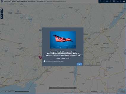
8 8 International Response Tomnod campaign by DigitalGlobe, May 6 to 9 Crowd-sourced image interpretation for damaged buildings Images from WorldView-2 WorldView-3, and GeoEye-1 acquired May 4 and 5


9 9 International Response CNES/Airbus SPOT-7, May 6 Value added product showing damaged buildings and affected areas from TomNod Filtered by number of users in agreement and visual interpretation of ancillary data Smoke-free optical images were a challenge!

10 10 NRCan s Response Most products available to emergency services as Web Mapping Service and webmap Interactive tools provide multiple ways of understanding the data

11 11 NRCan s Response Earth Observation satellite provided timely situational awareness Helped decision makers understand the fire progression over time Enabling data driven decision making Energy Supply Disruption Emergency Infrastructure First Nations Reserves


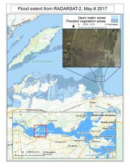
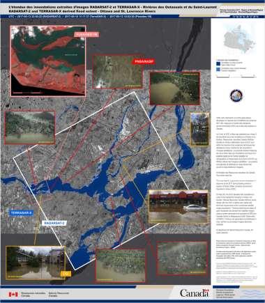
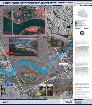
12 2017 Flood Season Distribution of 377 RADARSAT-2 Acquisitions
13 Québec Flooding: Charter Data Timeline

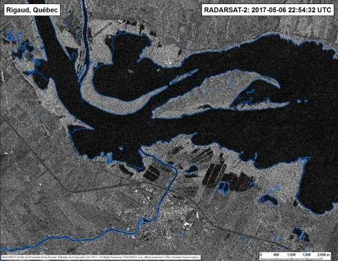
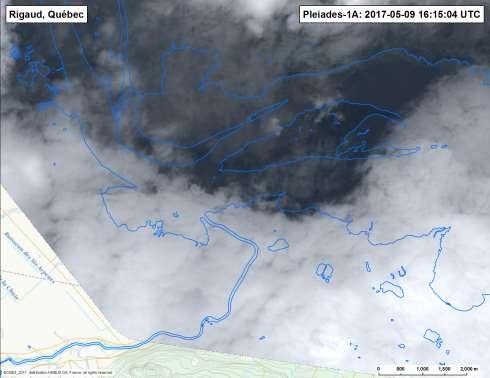
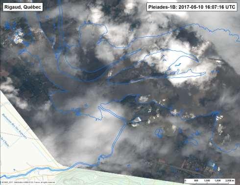
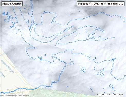
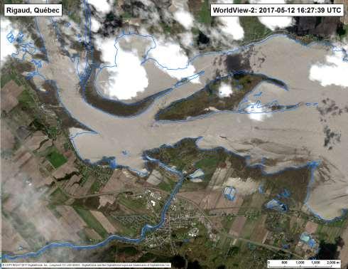
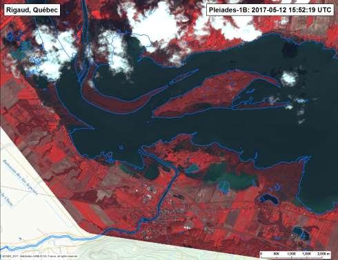
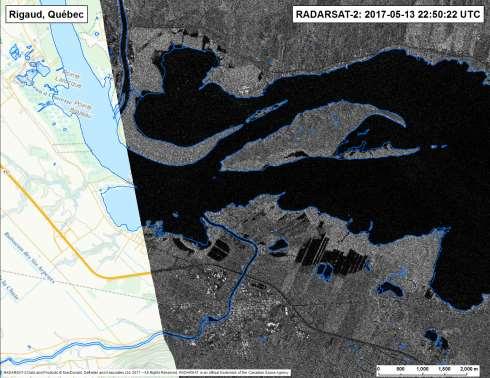
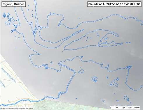
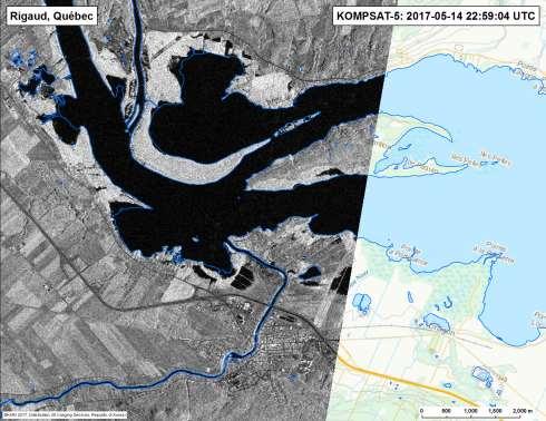
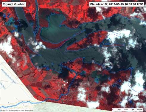
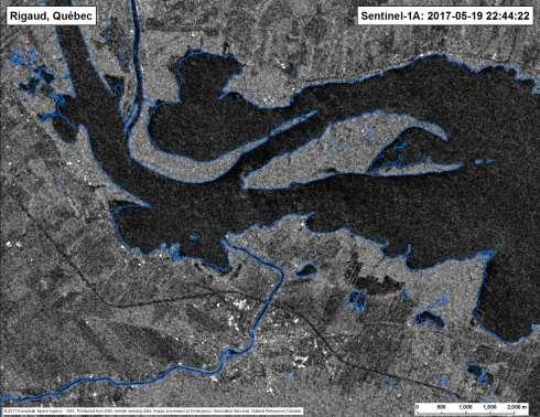
14 Rigaud Flooding 14

15 Gatineau Flooding 1101 people evacuated Canadian army mobilised 900 Gatineau municipal employees and 1200 volunteers sandbagging 2 day shut down of federal and provincial offices


16 National Aerial Surveillance Program May 7 16, 2017 Transport Canada aerial surveillance aircraft were tasked to capture flood images along waterfronts stretching from Quebec City to Pembroke to Oshawa. Four flight zones were defined, with flights rotating through each of those zones over the 10 day period. Images were captured at a frequency of once every 5 seconds during flights. A total of nearly 14,000 photographs were taken during the period. 4
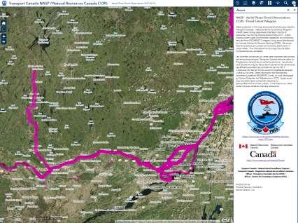
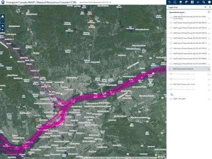
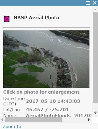

17 Online Interactive Maps for Aerial Photos


18 Crowdsourced Geographic Information Real time field observations Mapping validation Emergency response

19 Crowdsourced Geographic Information Real time field observation Mapping validation Emergency response


20 Maximum Flood Extent Map Flood extent for damage assessement

21 Timely situational awareness Data driven decision making Great example of international cooperation For further information on our emergency mapping services:
22
23
 ON-DUTY OPERATOR (ODO) MEMBER AGENCY")
 VALUE-ADDED PROVIDER (VAP) EGS")
24 Charter Activation Process EMERGENCY ON-CALL OFFICER (ECO) ON-DUTY OPERATOR (ODO) MEMBER AGENCY MISSION PLANNING AUTHORIZED USER (AU) PROJECT MANAGER (PM) VALUE-ADDED PROVIDER (VAP) EGS DISASTER END USER (EU)

25 25 NRCan s Response Integrating web map service layers from other federal departments Hotspot detection from thermal sensors and fire perimeter estimation by Canadian Forest Service Wind direction from Environment Canada Maps created twice daily
KARI Activation for the International Disasters
 KARI Activation for the International Disasters 5 th Joint Project Team Meeting for Sentinel Asia STEP2 (JPTM2012) 14 th Nov 2012 Boyeol Yoon Senior Researcher, Satellite Information Research Center (SIRC)
International Charter: Space and Major Disasters
 International Charter: Space and Major Disasters UNESCAP Training Workshop Kathmandu Nepal 30-31 Oct 2017 Dr. N K Shrivastava (shrivastava.nk@gmail.com) Former Charter Executive Secretariat Member Dy.
The International Charter Space and Major Disasters is further strengthening its contribution to disaster management worldwide.
 28 September 2012 Issue 3 The International Charter Space and Major Disasters is further strengthening its contribution to disaster management worldwide. Building on a decade of success in making satellite
Exploitation of PROBA CHRIS/HRC data in the context of the International Charter on Space and Major Disasters
 Exploitation of PROBA CHRIS/HRC data in the context of the International Charter on Space and Major Disasters F. Sarti (ESA/ESRIN) H. Yesou, R. Andreoli, S.Clandillon (SERTIT) Charter Member Agencies ESA
Flood SensorWeb Dan Mandl / Fritz Policelli NASA/GSFC
 Flood SensorWeb Dan Mandl / Fritz Policelli NASA/GSFC 10-16-08 1 Purpose Vision of Flood Sensor Web Present status of Flood SensorWeb initiative Some relevant examples from Fire SensorWeb efforts Goal
Sentinel Asia Data Provider Node Report
 Sentinel Asia Data Provider Node Report Joint Project Team Meeting for Sentinel Asia STEP3 (JPTM2018) 23 24 January 2018, Taipei, Taiwan Yuji TAKADA Space Applications and Operations Center (SAOC) Japan
Emergency Management Service (EMS) mapping
 mapping") GMES Emergency Management Service (EMS) mapping Frédéric BASTIDE GMES unit, European Commission UN-SPIDER Expert Meeting: "Crowdsource Mapping for Disaster Risk Management and Emergency Response" 3-5 December,
GMES Emergency Management Service (EMS) mapping Frédéric BASTIDE GMES unit, European Commission UN-SPIDER Expert Meeting: "Crowdsource Mapping for Disaster Risk Management and Emergency Response" 3-5 December,
Observation (EO) & Geomatics in Canada
 & Geomatics in Canada") Innovating to Increase the Impact of Earth Observation (EO) & Geomatics in Canada Natural Resources Canada February 25, 2014 Prashant Shukle, Director General Canada Centre for Mapping and Earth Observation
Innovating to Increase the Impact of Earth Observation (EO) & Geomatics in Canada Natural Resources Canada February 25, 2014 Prashant Shukle, Director General Canada Centre for Mapping and Earth Observation
Impact Policies Enabling Value Enhancement of Geospatial Information in Canadian Economy and Society
 1 Impact Policies Enabling Value Enhancement of Geospatial Information in Canadian Economy and Society May 26, 2015 Prashant Shukle, Director General Canada Centre for Mapping and Earth Observation Increased
Agency Vision and Decision- Maker Needs: A USGS Perspective
 Agency Vision and Decision- Maker Needs: A USGS Perspective Connecting Grassroots to Government for Disaster Management David Applegate USGS Associate Director for Natural Hazards September 13, 2012 U.S.
Norwegian spatial data infrastructure supporting disaster risk management Norwegian Mapping Authority
 Norwegian spatial data infrastructure supporting disaster risk management Norwegian Mapping Authority Arvid Lillethun, Norwegian Mapping Authority Land and Poverty 2018 Conference, World Bank 19.-23. March
Copernicus Today and Tomorrow GEO Week Group on Earth Observation Geneva, 16 January 2014 The Copernicus Space Infrastructure
 Copernicus Today and Tomorrow GEO Week Group on Earth Observation Geneva, 16 January 2014 The Copernicus Space Infrastructure Thomas Beer, Policy Coordinator, Copernicus Space Office, ESA-ESRIN, Frascati
Copernicus Overview and Emergency Management Service
 Copernicus Overview and Emergency Management Service Frédéric BASTIDE European Commission Open informal session of the United Nations Inter-Agency Meeting on Outer Space Activities 12 March 2013, Geneva
ZRCSAZU. Remote sensing and Earth observation data at ZRC SAZU. dr. Tatjana Veljanovski Atrij ZRC Ljubljana
 ZRCSAZU Remote sensing and Earth observation data at ZRC SAZU dr. Tatjana Veljanovski 2016-06-08 Atrij ZRC Ljubljana Remote Sensing Department Remote Sensing Department 20 years of experience application,
The Inter-Agency Space Debris Coordination Committee (IADC)
") The Inter-Agency Space Debris Coordination Committee (IADC) An overview of IADC s annual activities Mitsuru Ohnishi, JAXA, Japan IADC Chair www.iadc-online.org 55 th Session of the Scientific and Technical
The Inter-Agency Space Debris Coordination Committee (IADC) An overview of IADC s annual activities Mitsuru Ohnishi, JAXA, Japan IADC Chair www.iadc-online.org 55 th Session of the Scientific and Technical
Jeopardy. Final Jeopardy $100 $100 $100 $100 $100 $200 $200 $200 $200 $200 $300 $300 $300 $300 $400 $400 $400 $500 $500 $500 $500 $500
 Jeopardy Earthquakes Volcanoes Tsunamis Wildfires Landslides/ Droughts $100 $100 $100 $100 $100 $200 $200 $200 $200 $200 $300 $300 $300 $300 $300 $400 $400 $400 $400 $400 $500 $500 $500 $500 $500 Final
The BEYOND Center of Excellence for monitoring natural disasters from space
 The BEYOND Center of Excellence for monitoring natural disasters from space Ioannis Papoutsis National Observatory of Athens Institute for Astronomy, Astrophysics, Space Applications & Remote Sensing MOWE-IT
SDG s and the role of Earth Observation
 SDG s and the role of Earth Observation Christian Heipke IPI - Institute for Photogrammetry and GeoInformation Leibniz Universität Hannover Germany Secretary General, ISPRS 1. No Poverty 2. Zero Hunger
Geospatial Policy Development and Institutional Arrangements *
 HIGH LEVEL FORUM ON GLOBAL GEOSPATIAL MANAGEMENT INFORMATION WORKING PAPER No. 13 First Forum Seoul, Republic of Korea, 24-26 October 2011 Geospatial Policy Development and Institutional Arrangements *
EO Information Services. Assessing Vulnerability in the metropolitan area of Rio de Janeiro (Floods & Landslides) Project
 Project") EO Information Services in support of Assessing Vulnerability in the metropolitan area of Rio de Janeiro (Floods & Landslides) Project Ricardo Armas, Critical Software SA Haris Kontoes, ISARS NOA World
EO Information Services in support of Assessing Vulnerability in the metropolitan area of Rio de Janeiro (Floods & Landslides) Project Ricardo Armas, Critical Software SA Haris Kontoes, ISARS NOA World
sentinel-2 COLOUR VISION FOR COPERNICUS
 sentinel-2 COLOUR VISION FOR COPERNICUS SATELLITES TO SERVE By providing a set of key information services for a wide range of practical applications, Europe s Copernicus programme is providing a step
Canada Report Preamble
 CANADA REPORT 2016 Canada Report 2016 Preamble The 2016 Fire Season can be described as extremely challenging through the first part of the season in May and early June with a prolonged, relatively benign
AND THE COOPERATION WITH SENTINEL ASIA FOR DISASTER MANAGEMENT
 Ministry of Natural resources and Environment National Remote Sensing DEpartment NATIONAL REMOTE SENSING DEPARTMENT (NRSD) AND THE COOPERATION WITH SENTINEL ASIA FOR DISASTER MANAGEMENT By: Dr. Chu Hai
CNES actions towards risk mitigation and climate change monitoring
 United nations / Germany International Conference: International cooperation Towards Low-Emission and Resilient Societies 22-24 Nov 2017, Bonn CNES actions towards risk mitigation and climate change monitoring
NGIAs' roles in successful disaster response
 The Second UN-GGIM-AP Plenary Meeting NGIAs' roles in successful disaster response Japan Teheran Iran 28 October 2013 Shin-ichi SAKABE, Director of International Affairs Division Geospatial Information
Satellite Remote Sensing for Ocean
 Satellite Remote Sensing for Ocean August 17, 2017 Masatoshi Kamei RESTEC All rights reserved RESTEC 2015 Contents 1. About RESTEC and Remote Sensing 2. Example of Remote Sensing Technology 3. Remote Sensing
The Inter-Agency Space Debris Coordination Committee (IADC)
") The Inter-Agency Space Debris Coordination Committee (IADC) An overview of the IADC annual activities Holger Krag, ESA IADC Chair www.iadc-online.org 54 th Session of the Scientific and Technical Subcommittee
The Inter-Agency Space Debris Coordination Committee (IADC) An overview of the IADC annual activities Holger Krag, ESA IADC Chair www.iadc-online.org 54 th Session of the Scientific and Technical Subcommittee
Weather Satellite Data Applications for Monitoring and Warning Hazard at BMKG
 The 5th Meeting of the Coordinating Group of the RA II WIGOS Satellite Project 21 October 2017, Vladivostok city, Russky Island, Russia Far Eastern Federal University Weather Satellite Data Applications
GEO-VIII November Geohazard Supersites and Natural Laboratories Progress Report. Document 9
 GEO-VIII 16-17 November 2011 Geohazard Supersites and Natural Laboratories Progress Report Document 9 This document is submitted to GEO-VIII for information. Geohazard Supersites and Natural Laboratories
Roles of NGII in successful disaster management
 The Second UN-GGIM-AP Plenary Meeting Roles of NGII in successful disaster management Republic of Korea Teheran Iran 28 October 2013 Sanghoon Lee, Ph.D. NGII Outline Type of Disasters Occur in Korea Practical
Report of the Working Group 2 Data Sharing and Integration for Disaster Management *
 UNITED NATIONS E/CONF.104/6 ECONOMIC AND SOCIAL COUNCIL Twentieth United Nations Regional Cartographic Conference for Asia and the Pacific Jeju, 6-9 October 2015 Item 5 of the provisional agenda Report
Securing EUMETSAT s Mission from an Evolving Space Environment
 Securing EUMETSAT s Mission from an Evolving Space Environment ESPI 12 th Autumn Conference Andrew Monham 1 EUMETSAT: Intergovernmental Organisation of 30 Member States Presentation Contents AUSTRIA BELGIU
A 2016 CEOS Chair Initiative. Non-meteorological Applications for Next Generation Geostationary Satellites
 A 2016 CEOS Chair Initiative Committee on Earth Observation Satellites Non-meteorological Applications for Next Generation Geostationary Satellites Co-chaired by EUMETSAT (Holmlund), CSIRO (Schroeder),
Natural Processes. Were you prepared for the fast approaching storm? Were you able to take shelter? What about pets, livestock or plants?
 Have you ever been caught in a storm? You are outside on a summer night and all of a sudden here come the wind, lightning and heavy rain. It starts raining so hard that you can hardly see in front of you.
Geo-information and Disaster Risk Reduction in the Hindu Kush-Himalayan region
 Geo-information and Disaster Risk Reduction in the Hindu Kush-Himalayan region Basanta Shrestha, Division Head MENRIS, International Centre for Integrated Mountain Development Kathmandu, Nepal The International
Disaster Management and Spatial Data An Experience of Sri Lanka for Joint project team meeting 2012
 Disaster Management and Spatial Data An Experience of Sri Lanka for Joint project team meeting 2012 1 by Padma Kumara Withana Provincial Surveyor General Uva Province 2 Out line ü Introduction ü Natural
The importance of satellite data and products for RA1 in the WWRP strategy. Estelle de Coning World Weather Research Division
 The importance of satellite data and products for RA1 in the WWRP strategy Estelle de Coning World Weather Research Division Kofi Annan former UN Secretary-General (21 July 2016) "The poor need alerts
IDENTIFICATION OF HAZARDS OF CONCERN
 IDENTIFICATION OF HAZARDS OF CONCERN To provide a strong foundation for mitigation strategies considered in Section 6, the Village considered a full range of hazards that could impact the area and then
IADC Re-Entry Prediction Campaigns
 IADC Re-Entry Prediction Campaigns H. Klinkrad, ESA IADC chair UNCOPUOS STSC, Feb 2009 page 1 Presentation Outline terms of reference of the Inter-Agency Space Debris Coordination Committee (IADC) concept
GEOMATICS. Shaping our world. A company of
 GEOMATICS Shaping our world A company of OUR EXPERTISE Geomatics Geomatics plays a mayor role in hydropower, land and water resources, urban development, transport & mobility, renewable energy, and infrastructure
Remote sensing data uses and supply in Vietnam. Dr. Chu Hải Tùng National Remote Sensing Department, Ministry of Natural Resource and Environment
 Remote sensing data uses and supply in Vietnam Dr. Chu Hải Tùng National Remote Sensing Department, Ministry of Natural Resource and Environment Content Uses of remote sensing data in Vietnam Roles of
2018 NASCIO Award Submission Category: Cross-Boundary Collaboration and Partnerships. Project Title: Tennessee Wildfires: A Coordinated GIS Response
 2018 NASCIO Award Submission Category: Cross-Boundary Collaboration and Partnerships Project Title: Tennessee Wildfires: A Coordinated GIS Response Sevier County, Tennessee State of Tennessee, Emergency
Global Map: A Tool for Disaster Mitigation for the Asia and Pacific Region
 Global Map: A Tool for Disaster Mitigation for the Asia and Pacific Region D. R. Fraser Taylor Chair, International Steering Committee for Global Mapping (ISCGM) fraser_taylor@carleton.ca www. 18 th United
NASA Disasters Program Approach/Principles
 Strengthening Disaster Risk Reduction and Reslience the Contributions of Earth Observations Dr. David Green Disasters Program Science Mission Directorate Earth Science Division UNITED NATIONS ESCAP Economic
GEOMATICS AND DISASTER MANAGEMENT: Early Impact assessment in Haiti
 GEOMATICS AND DISASTER MANAGEMENT: Early Impact assessment in Haiti We will talk about... Post-disaster response: the main questions to be answered Post-disaster rapid mapping: the role of Geomatics The
GI Technology for Disaster Management
 GI Technology for Disaster Management 17 th ICC on the Regional Space Applications Programme for Sustainable Development (RESAP) 26 th Nov 2013 Bangkok Thailand Period and time of seasonal in thailand
CEOS Support to the Geohazard Supersites
 The CEOS Supersite Coordination Team: Simona Zoffoli, ASI Steven Hosford, CNES Christine Giguère, CSA Jörn Hoffmann, DLR (Chair) Wolfgang Lengert, ESA Kazuo Umezawa, JAXA Shizu Yabe, JAXA Francis Lindsay,
Assessing Hazards and Risk
 Page 1 of 6 EENS 204 Tulane University Natural Disasters Prof. Stephen A. Nelson Assessing Hazards and Risk This page last updated on 07-Jan-2004 As discussed before, natural disasters are produced by
STEUBEN COUNTY, NEW YORK. Hazard Analysis Report
 STEUBEN COUNTY, NEW YORK Hazard Analysis Report Prepared by: April 1, 2014 Background On April 1, 2014 the Steuben County Office of Emergency Management conducted a hazard analysis using the automated
Georeferencing and Satellite Image Support: Lessons learned, Challenges and Opportunities
 Georeferencing and Satellite Image Support: Lessons learned, Challenges and Opportunities Shirish Ravan shirish.ravan@unoosa.org UN-SPIDER United Nations Office for Outer Space Affairs (UNOOSA) UN-SPIDER
ASSESSMENT AND RESTORATION OF COASTAL ECOSYSTEMS USING REMOTE SENSING AND VISUALIZATION TOOLS FOR THE GULF OF MEXICO AND BEYOND
 ASSESSMENT AND RESTORATION OF COASTAL ECOSYSTEMS USING REMOTE SENSING AND VISUALIZATION TOOLS FOR THE GULF OF MEXICO AND BEYOND Remote Sensing as a Tool for Ecosystem Restoration George Graettinger Office
The Role of the Louisiana Geographic Information Center in the Response to Hurricane Katrina
 The Role of the Louisiana Geographic Information Center in the Response to Hurricane Katrina By: Jared Chapiewsky & Laura Brown For: URPL 969- GIS Applications in Response to Hurricane Katrina Date: March
Remote Sensing and Incident Support. Department of Homeland Security February 22, 2013
 Remote Sensing and Incident Support Department of Homeland Security February 22, 2013 Introductions and Goals Today s Webcast will be Presented by: Chris Barnard DHS Remote Sensing Advisor Chris Vaughan
Introduction of Sichuan Surveying and Mapping Emergency System. Zheng Quanhong Sichuan Bureau of Surveying.Mapping and Geoinformation September 2016
 Introduction of Sichuan Surveying and Mapping Emergency System Zheng Quanhong Sichuan Bureau of Surveying.Mapping and Geoinformation September 2016 Background Sichuan province is one of the most serious
Fort Lauderdale s GIS Supports Response to. Hurricane Irma
 Fort Lauderdale s GIS Supports Response to Hurricane Irma By Monica Pratt, ArcUser Editor When Hurricane Irma first made landfall in the Florida Keys on September 10, 2017, it brought destructive 70 mph
GMES EURORISK Geo-information services for natural and man-made risks management
 GMES EURORISK Geo-information services for natural and man-made risks management 8/11/2004 EURORISK A European scale approach for developing, delivering and operationally exploiting new information services
The Polar Ice Sheets Monitoring Project A Coordinated Response from Space Agencies
 The Polar Ice Sheets Monitoring Project A Coordinated Response from Space Agencies Yves Crevier / Members of the PSTG SAR Coordination WG Canadian Space Agency CEOS SIT-28 Meeting Hampton, Virginia, USA
EUMETSAT. A global operational satellite agency at the heart of Europe. Presentation for the Spanish Industry Day Madrid, 15 March 2012
 EUMETSAT A global operational satellite agency at the heart of Europe Presentation for the Spanish Industry Day Madrid, Angiolo Rolli EUMETSAT Director of Administration EUMETSAT objectives The primary
Why Hydrological Services are Important to Business
 Why Hydrological Services are Important to Business Dr. David Green Program Manager, Disasters Earth Science Division David.s.green@nasa.gov May 8, 2018 2 Communities and Areas of Intensive Risk Socio-Economic
F I G PA RT LX capacity in natural disaster area and disaster survey case in Jeju area
 F I G PA RT 7 2017. 12. 6. LX capacity in natural disaster area and disaster survey case in Jeju area Reporting order 1 2 3 General Information of LX Competence of LX on Natural disaster area Examples
EXTRACTION OF FLOODED AREAS DUE THE 2015 KANTO-TOHOKU HEAVY RAINFALL IN JAPAN USING PALSAR-2 IMAGES
 EXTRACTION OF FLOODED AREAS DUE THE 2015 KANTO-TOHOKU HEAVY RAINFALL IN JAPAN USING PALSAR-2 IMAGES F. Yamazaki a, *, W. Liu a a Chiba University, Graduate School of Engineering, Chiba 263-8522, Japan
They include earthquakes, volcanic eruptions, floods, landslides, and other processes and occurrences. They are included in the broader concept of.
 They include earthquakes, volcanic eruptions, floods, landslides, and other processes and occurrences. They are included in the broader concept of. In general, natural processes are labeled hazardous only
Satellite Meteorology. Protecting Life and Property Around the World
 Satellite Meteorology Protecting Life and Property Around the World The Value of Forecasting Severe Weather Flooding events across Europe in August 2002 cost in the region of 20 billion; 20,000 people
Davida Streett NOAA/NESDIS. NESDIS Satellite Analysis Branch Hazard Mitigation Programs
 ESA 2010 Oil Davida Streett NOAA/NESDIS NESDIS Satellite Analysis Branch Hazard Mitigation Programs Operational 24 x 7 x 365 Fire and Smoke Precipitation Tropical Storms/Hurricanes Oil/Marine Pollution
Wildfire WG Monitoring of Heat Related Disaster using Volcano and Wildfire monitoring system
 Wildfire WG Monitoring of Heat Related Disaster using monitoring system 2018 11 01 Koji Nakau, JAXA/SAOC Topics Fire danger related indexes monitoring system Volcano monitoring Although this is Wildfire
US/Global Natural Catastrophe Update
 US/Global Natural Catastrophe Update NAIC's CIPR Symposium on Implications of Increasing Catastrophe Volatility on Insurers Carl Hedde, SVP, Head of Risk Accumulation Munich Reinsurance America, Inc. Source:
What are the social, technical, environmental and economic benefits and opportunities of accessing and sharing geodetic data?
 What are the social, technical, environmental and economic benefits and opportunities of accessing and sharing geodetic data? Graeme Blick Group Manager Positioning and Resilience Land Information New
Mapping Coastal Change Using LiDAR and Multispectral Imagery
 Mapping Coastal Change Using LiDAR and Multispectral Imagery Contributor: Patrick Collins, Technical Solutions Engineer Presented by TABLE OF CONTENTS Introduction... 1 Coastal Change... 1 Mapping Coastal
Current and Upcoming NASA Hurricane Measurement Missions National Hurricane Conference
 NASA Science Mission Directorate Earth Science Division Applied Sciences Program Current and Upcoming NASA Hurricane Measurement Missions National Hurricane Conference April 18, 2017 Formulation Implementation
EMERGENCIES PREVENTION AND RESPONSE WITH APPLICATION OF SPACE OBSERVATION SYSTEMS
 JSC RUSSIAN SPACE SYSTEMS RUSSIAN FEDERATION RESEARCH CENTER RUSSIAN FOR FEDERAL EARTH SPACE OPERATIVE AGENCY MONITORING EMERGENCIES PREVENTION AND RESPONSE WITH APPLICATION OF SPACE OBSERVATION SYSTEMS
FOREST FIRE. News August 15, :00am. Great progress continues to be made extinguishing hot spots on Parry Sound Fire 033.
 FOREST FIRE News August 15, 2018 8:00am Parry Sound 33 Fire Update Great progress continues to be made extinguishing hot spots on Parry Sound Fire 033. Hot weather continues to hold on which has caused
L i n k i n g f l o o d i m p a c t f o r e c a s t i n g a n d s a t e l l i t e r a p i d m a p p i n g i n E u r o p e
 L i n k i n g f l o o d i m p a c t f o r e c a s t i n g a n d s a t e l l i t e r a p i d m a p p i n g i n E u r o p e Francesco Dottori, Milan Kalas, Peter Salamon, Annett Wania, Ines Rivero (EC JRC)
International Charter "Space & Major Disasters"
 International Charter Space & Major Disasters Annual Report 2016 Page 1 Page 2 CONTENTS 1 INTRODUCTION... 5 1.1 PURPOSE AND SCOPE OF THIS DOCUMENT... 5 1.2 STRUCTURE OF THE REPORT... 5 1.3 APPLICABLE DOCUMENTS...
An overview of the applications for early warning and mapping of the flood events in New Brunswick
 Flood Recovery, Innovation and Reponse IV 239 An overview of the applications for early warning and mapping of the flood events in New Brunswick D. Mioc 1, E. McGillivray 2, F. Anton 1, M. Mezouaghi 2,
Direct Readout at the Meteorological Service of Canada
 Direct Readout at the Meteorological Service of Canada CSPP Users Meeting 2015 Darmstadt, Germany April 14-16, 2015 David Bradley Manager, Earth Observation and Geomatics Meteorological Service of Canada
Geospatial natural disaster management
 Geospatial natural disaster management disasters happen. are you ready? Natural disasters can strike almost anywhere at any time, with no regard to a municipality s financial resources. These extraordinarily
NATURAL FORCE THREATS, MONITORING AND RESEARCH NEEDS
 NATURAL FORCE THREATS, MONITORING AND RESEARCH NEEDS 1 Southern California Thomas Fire and Montecito Debris Flows 2 Timeline/Description of Conditions Between December 4, 2017 and January 12, 2018, over
Using Remote Sensing Technologies to Improve Resilience
 4 Using Remote Sensing Technologies to Improve Resilience Ronald T. Eguchi CEO, ImageCat, Inc. 6 years ago The world had just survived the Y2K bug with no major incidents Nations around the world commit
Country Report - Singapore
 Country Report - Singapore The 5th Meeting of the Coordinating Group Vladivostok city, Russky Island, Russia Far Eastern Federal University of the RA II WIGOS Satellite Project 21 October 2017 Outline
Detecting Landscape Changes in High Latitude Environments Using Landsat Trend Analysis: 2. Classification
 1 Detecting Landscape Changes in High Latitude Environments Using Landsat Trend Analysis: 2. Classification Ian Olthof and Robert H. Fraser Canada Centre for Mapping and Earth Observation Natural Resources
3Chapter Three: Rescue and Response
 17 16 Report Science Title and the Storms: the USGS Response to the Hurricanes of 2005 3Chapter Three: Rescue and Response This chapter documents the U.S. Geological Survey s (USGS) humanitarian rescue
2014 Annual Mitigation Plan Review Meeting
 2014 Annual Mitigation Plan Review Meeting Highland County EMA MEETING OBJECTIVES Understand Your Natural Disaster Risk Review of Previous Plans Current Plan Status Future Activity Plan/Needs of Each Community
Shiro Ochi JAXA
 SESSION 4: Sharing Knowledge and Good Practices by Regional Experts Our Experiences from Japan, Asia and International community Shiro Ochi GIC@AIT, JAXA International Disaster Charter Framework Sentinel
Climate Risk Visualization for Adaptation Planning and Emergency Response
 Climate Risk Visualization for Adaptation Planning and Emergency Response NCR Flood Fact Finding Workshop Ricardo Saavedra ricardo@vizonomy.com Social Media, Mobile, and Big Data St. Peter s Basilica,
Airbus DS Consortium Risk and Recovery. Airbus DS Corporate Presentation
 Airbus DS Consortium Risk and Recovery 1 January, 2017 Airbus DS Corporate Presentation 2 SERTIT s Copernicus EMS mapping service Risk & Recovery and Rapid Mapping Based on our 24/7/365 operational rapid
Geographic Information Systems(GIS)
") Geographic Information Systems(GIS) Threat Analysis Techniques Overview What is GIS? Functional capabilities of GIS BCM Process and GIS How to leverage GIS in threat/risk analysis Ron Brown, CBCP Managing
Geographic Information Systems(GIS) Threat Analysis Techniques Overview What is GIS? Functional capabilities of GIS BCM Process and GIS How to leverage GIS in threat/risk analysis Ron Brown, CBCP Managing
National Weather Service. Building a Weather Ready Nation
 National Weather Service Building a Weather Ready Nation The NWS is a federal agency Department of Commerce National Oceanic and Atmospheric Administration National Weather Service Today s National Weather
Emergency Preparedness Questions
 Emergency Preparedness Questions 1. A family emergency plan should NOT include which of the following? a) Information about your children's school(s) b) The name and phone number of an out-of-town contact
COMMUNITY EMERGENCY RESPONSE TEAM
 COMMUNITY EMERGENCY RESPONSE TEAM INSTRUCTOR GUIDE 40 hour curriculum DEVELOPED FOR: FEDERAL EMERGENCY MANAGEMENT AGENCY EMERGENCY MANAGEMENT INSTITUTE UNITED STATES FIRE ADMINISTRATION DEVELOPED BY: HUMAN
Watching Earth From Space
 Watching Earth From Space A Reading A Z Level N Leveled Book Word Count: 670 LEVELED BOOK N Watching Earth From Space Written by David Dreier Visit www.readinga-z.com for thousands of books and materials.
EuroGEOSS Protected Areas Pilot
 EuroGEOSS Protected Areas Pilot Max Craglia European Commission Joint Research Centre Part 1: the present MyNatura2000 Mobile app. Awareness raising & volunteered data collection. Natura2000 covers 18%
Data Origin. Ron van Lammeren CGI-GIRS 0910
 Data Origin Ron van Lammeren CGI-GIRS 0910 How to obtain geodata? Geo data initiative Executive Order 12906, "Coordinating Geographic Data Acquisition and Access: The National Spatial Data Infrastructure,"
Effective Utilization of Synthetic Aperture Radar (SAR) Imagery in Rapid Damage Assessment
 Imagery in Rapid Damage Assessment") Effective Utilization of Synthetic Aperture Radar (SAR) Imagery in Rapid Damage Assessment Case Study Pakistan Floods SUPARCO M. Maisam Raza, Ahmad H. Rabbani SEQUENCE Flood Monitoring using Satellite
Effective Utilization of Synthetic Aperture Radar (SAR) Imagery in Rapid Damage Assessment Case Study Pakistan Floods SUPARCO M. Maisam Raza, Ahmad H. Rabbani SEQUENCE Flood Monitoring using Satellite
COPERNICUS SPACE DATA OFFER FOR PUBLIC AUTHORITIES DISTRIBUTED BY ESA
 COPERNICUS SPACE DATA OFFER FOR PUBLIC AUTHORITIES DISTRIBUTED BY ESA The Copernicus Space Component Data Access (CSC-DA) service - financed by the EU and operated by ESA - grants National Public Authorities
Crisis Management and Natural Disasters Overview of JRC operational or pre-operational activities A. Annunziato, D. Al-Khudhairy
 Papagayo, Costarica 3-4 November 2009 Security Science and The Americas 1 Joint Research Centre (JRC) Crisis Management and Natural Disasters Overview of JRC operational or pre-operational activities A.
Comprehensive Emergency Management Plan
 Comprehensive Emergency Management Plan Section 6- Severe Weather/Wildfire Annex Blank Intentionally 2 CEMP Annex 6 11 Severe Weather / Wildfire Annex I. PURPOSE This plan outlines the procedures to be
New NASA Ocean Observations and Coastal Applications
 New NASA Ocean Observations and Coastal Applications Duane Armstrong Chief, Applied Science & Technology Project Office August 20, 2014 1 Outline NASA s new Earth Science Ocean Science Missions for 2014
DIPLOMA IN DISASTER MANAGEMENT. (Non-Semester) (With effect from the academic year )
 (With effect from the academic year )") DIPLOMA IN DISASTER MANAGEMENT (Non-Semester) (With effect from the academic year 2013-14) Eligibility for the Course Candidate should have passed the Higher Secondary Examination conducted by the Board
DIPLOMA IN DISASTER MANAGEMENT (Non-Semester) (With effect from the academic year 2013-14) Eligibility for the Course Candidate should have passed the Higher Secondary Examination conducted by the Board
Geohazard Supersites and Natural Laboratories
 Geohazard Supersites and Natural Laboratories FRINGE 2011, Frascati, Italy, September 19, 2011 Wolfgang Lengert, ESA Falk Amelung, University of Miami, GEO task lead Craig Dobson, NASA, CEOS task lead
FMI & MULTIHAZARD EARLY WARNING SYSTEMS
 FMI & MULTIHAZARD EARLY WARNING SYSTEMS Prof. Petteri Taalas Director General FMI FMI Director General 4.1.2016 PETTERI TAALAS, BACKGROUND Director General of the Finnish Meteorological Institute 2002-5,