Natural stone assessment with ground penetrating radar (GPR)
|
|
|
- Abel Gibson
- 6 years ago
- Views:
Transcription
1 Natural stone assessment with ground penetrating radar (GPR) The 15th Meeting of the Association of European Geological Societies September 2007 Tallinn, Estonia Hannu Luodes


2 Location of the study areas 2

3 The ground penetrating radar instrumentation GSSI SIR 2000 control unit Antennae between 40 MHz and 400 MHz 200 MHz antenna Control unit 3

4 Natural stone assessment with ground penetrating radar (GPR) Study area 1 Porphyritic granite situated in the south-eastern Finland It belongs to the Central Finland granitoid complex and is described postkinematic in relation to the deformation of the area 4

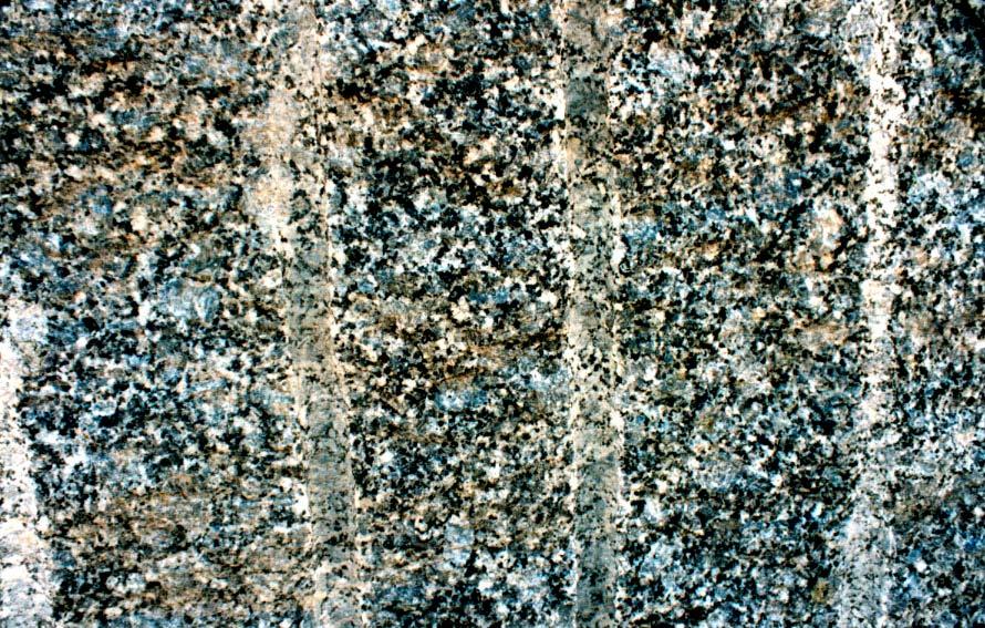
5 Study area 1 5
6 Study area 1 Typical feature of the rock is a strong horizontal exfoliation type fracturing (height of the bench about 5 m) 6

7 Study area 1 GPR measurement traverse of 65 m in length (vertical and horizontal scale are equal) The profile was corrected with altitude data to present the actual surface and fractures orientation 7

8 Study area 1 The GPR was able to detect the major horizontal and sub-horizontal fracturing 8

9 Study area 1 Vertical or near vertical fractures were difficult to detect due to their small reflection surface towards the measuring antenna 9

10 Study area 1 The horizontal fractures near the surface were sometimes strongly weathered providing space for surface water to collect Those spots were detected as individual targets on the radar measurement profile The spots can be thought to be reflections from a subhorizontal fracture zone near the surface 10

11 Natural stone assessment with ground penetrating radar (GPR) Study area 2 Soapstone situated in North Karelia It belongs to an Archaean greenstone belt, in the border zone between the Archaean area and the Palaeoproterozoic North Karelian Schist Belt 11

12 Study area 2 Typical North Karelian soapstone Sample size 260 mm x 200 mm 12

13 Study area 2 Soapstone quarry in North Karelia 13


14 Study area 2 With the soapstone, the measurements revealed more of the internal structure of the rock, making the detection of the fracturing complex Especially internal lineation was quite well visible in those sections where the stone contained more conductive minerals. 14


15 Study area 2 Large open horizontal fractures were detectable also in this stone type, which can be helpful in planning of the quarrying operations. 15
16 Conclusions Ground penetrating radar (GPR) is suitable for large-scale quality assessment of natural stone deposits and quarries The measurements are easy and quick to do and the preliminary results can be evaluated immediately The fracture detection level varies depending on the used equipment, mainly on the frequency The development in GPS technology has made it possible to position the measurements accurately and thus trace back the results into the quarry to help extraction planning The differences in the measurement results and their interpretation found among these two rock types indicate the importance of knowing the electromagnetic properties and mineralogy of the stone Also knowing the geological structure and other characteristics of the stone beforehand helps to avoid false interpretations 16
Natural stone assessment with ground penetrating radar
 doi:10.3176/earth.2008.3.03 Natural stone assessment with ground penetrating radar Hannu Luodes Geological Survey of Finland (GTK), P. O. Box 1237, FIN-70211 Kuopio, Finland; Hannu.Luodes@gtk.fi Received
GPR surveys at Nõmmküla Detection of underground water routes
 GPR surveys at Nõmmküla 2009 Detection of underground water routes Tomi Herronen & Timo Saarenketo 2009 1. Introduction The purpose of this survey was to locate possible underground water routes (rivers)
Natural stone exploration projects in the Finnish - Russian border zone Natural stone what it is?
 Natural stone what it is? Natural stone where is it used? DIMENSION STONES IN THE KARELIAN REPUBLIC - A PILOT STUDY 1998-2000 Evaluation of the present geological data related to dimension stone deposits
PALIN GRANIT OY. o China, Italy, Spain, Poland, Taiwan, Germany, Russia ROCKS AROUND THE WORLD.
 PALIN GRANIT OY Founded 1921, family-owned Quarrying and manufacturing blocks Quarries in SW and SE Finland Personnel 100 Annual production 40 000 m3 Export 90% o China, Italy, Spain, Poland, Taiwan, Germany,
SURVEYING FOR GOLD. Page 1 of 25
 SURVEYING FOR GOLD Page 1 of 25 Page 2 of 25 Contents Introduction to Lozar Radar... 4 The Ground Penetrating Radar (GPR) system and Methodology... 4 Lozar Radar Surveying for Gold... 7 How Lozar Radar
Hazard Mapping Along the Dead Sea Shoreline
 FIG Working Week in Marrakech, Morocco 18-22 May 2011 Hazard Mapping Along the Dead Sea Shoreline Rami Al-Ruzouq, Abdullah Al-Zuobi, AbdEl-Rahman Abueladas, Emad Akkawi Department of Surveying and Geomatics
A GPR ASSESSMENT OF THE PREHISTORIC NAPLES CANAL NAPLES, FLORIDA ARCHAEOLOGICAL AND HISTORICAL CONSERVANCY, INC.
 A GPR ASSESSMENT OF THE PREHISTORIC NAPLES CANAL NAPLES, FLORIDA ARCHAEOLOGICAL AND HISTORICAL CONSERVANCY, INC. AHC TECNICAL REPORT NO. 1004 DECEMBER 2013 A GPR ASSESSMENT OF THE PREHISTORIC NAPLES CANAL
GPR AS A COST EFFECTIVE BEDROCK MAPPING TOOL FOR LARGE AREAS. Abstract
 GPR AS A COST EFFECTIVE BEDROCK MAPPING TOOL FOR LARGE AREAS Dr. Jutta L. Hager, Hager GeoScience, Inc., Waltham, MA Mario Carnevale, Hager GeoScience, Inc., Waltham, MA Abstract Hager GeoScience, Inc.
Distribution: Ministry of Employment and the Economy 2 copies Kuhmo Metals Oy, Outokumpu Vulcan Resources Ltd, Perth
 K uhmo Metals Oy Kummunkatu 34 83500 Outokumpu, Finland Facsimile: +358 13 830 228 Distribution: Ministry of Employment and the Economy 2 copies Kuhmo Metals Oy, Outokumpu 1 copy Vulcan Resources Ltd,
Geophysical Investigation of a 19th Century Archeological Site, Boston College K. Corcoran, J. Hager, M. Carnevale
 Geophysical Investigation of a 19th Century Archeological Site, Boston College K. Corcoran, J. Hager, M. Carnevale Hager GeoScience, Inc., Waltham, MA ------------------------------------------------------------------------
NATURAL SOIL DEPOSITS
 NATURAL SOIL DEPOSITS Soils are produced by weathering of rock. Weathering is the physical or chemical breakdown of rock. Physical Processes: - Unloading - Frost Action - Organism Growth - Crystal Growth
INTRODUCTION Prospectivity mapping Study area and methods
 Quaternary geological and till geochemical studies in verifying GIS-based prospectivity mapping in the Central Lapland Greenstone Belt, northern Finland Sarala Pertti, Nykänen Vesa, Sarapää Olli, Peltoniemi
GEOPHYSICAL SITE CHARACTERIZATION IN SUPPORT OF HIGHWAY EXPANSION PROJECT
 GEOPHYSICAL SITE CHARACTERIZATION IN SUPPORT OF HIGHWAY EXPANSION PROJECT * Shane Hickman, * Todd Lippincott, * Steve Cardimona, * Neil Anderson, and + Tim Newton * The University of Missouri-Rolla Department
Comparison of geophysical. techniques to determine depth to. bedrock in complex weathered. environments of the Mount Crawford. region, South Australia
 Comparison of geophysical techniques to determine depth to bedrock in complex weathered environments of the Mount Crawford region, South Australia Thesis submitted in accordance with the requirements of
Endomines exploring the true potential of the Karelian Gold Line. 11th Fennoscandian Exploration and Mining Conference 1 November 2017
 Endomines exploring the true potential of the Karelian Gold Line 11th Fennoscandian Exploration and Mining Conference 1 November 2017 Disclaimer Statements in this presentation which are not purely historical
Ground Penetrating Radar Survey of a Portion of East End Cemetery, Cadiz, Kentucky
 Ground Penetrating Radar Survey of a Portion of East End Cemetery, Cadiz, Kentucky January 2011 Report prepared by Anthony L. Ortmann, Ph.D. Assistant Professor Department of Geosciences Murray State University
Discrimination between Archean A-type granitoids and sanukitoid suites using tectonic setting, geochemistry, and fertility type
 Discrimination between Archean A-type granitoids and sanukitoid suites using tectonic setting, geochemistry, and fertility type ZOZULYA DMITRY 1, EBY NELSON 2 1 - Geological Institute Kola Science Centre
Lima Project: Seismic Refraction and Resistivity Survey. Alten du Plessis Global Geophysical
 Lima Project: Seismic Refraction and Resistivity Survey Alten du Plessis Global Geophysical Report no 0706/2006 18 December 2006 Lima Project: Seismic Refraction and Resistivity Survey by Alten du Plessis
Hi-tech elements and REE in Finland Exploration proposal Tanhua mafic complex
 Hi-tech elements and REE in Finland Exploration proposal Tanhua mafic complex Central Lapland Greenstone Belt Alf Björklund Magnus Minerals Oy December 2017 magnusminerals.fi Alf Björklund Magnus Minerals
TRC1504: Alternative Uses of Ground Penetrating Radar in Highway in Construction and Maintenance. Elisha Wright-Kehner, P.E.
 TRC1504: Alternative Uses of Ground Penetrating Radar in Highway in Construction and Maintenance Elisha Wright-Kehner, P.E. Why GPR? Practicality Non-invasive (Non-destructive Testing - NDT) Real-time
Georadar and geoelectricity method to identify the determine zone of sliding landslide
 IOP Conference Series: Earth and Environmental Science PAPER OPEN ACCESS Georadar and geoelectricity method to identify the determine zone of sliding landslide To cite this article: Y K Dalimunthe and
Application of Ground Penetrating Radar for hydro-geological study
 Journal of Scientific & Industrial Research Vol. 65, February 2006, pp. 160-164 Application of Ground Penetrating Radar for hydro-geological study K K K Singh* Central Mining Research Institute, Dhanbad
POTENTIAL USE OF GROUND PENETRATING RADAR IN HIGHWAY ROCK CUT STABILITY Norbert H. Maerz* and Wooyoung Kim^ ABSTRACT INTRODUCTION
 Geophysics 2000, Dec. 11-15, 2000, St. Louis, MO, 9 pp. POTENTIAL USE OF GROUND PENETRATING RADAR IN HIGHWAY ROCK CUT STABILITY Norbert H. Maerz* and Wooyoung Kim^ *Rock Mechanics and Explosives Research
P Forsmark site investigation. Ground penetrating radar and resistivity measurements for overburden investigations
 P-03-43 Forsmark site investigation Ground penetrating radar and resistivity measurements for overburden investigations Johan Nissen, Malå Geoscience AB April 2003 Svensk Kärnbränslehantering AB Swedish
SOIL MECHANICS Geology
 14.330 SOIL MECHANICS FUNDAMENTALS OF ENGINEERING (FE) EXAM CALCULATOR POLICY (AS OF 01/23/13) http://ncees.org/exams/calculator-policy/ Casio: All fx-115 models. Examples of acceptable Casio fx-115 models
EOSC252 - Exercise 9
 Name: 1. Introduction EOSC252 - Exercise 9 Dielectric properties This is really nothing more than a multiple choice / short answer quiz-style assignment. You will need to have done the readings about dielectric
EES - Goal Rocks and Minerals
 EES - Goal 2.1 - Rocks and Minerals Score: 1. Quartz is a mineral because it is a white rock. natural, inorganic, and has a crystalline structure. an element. composed of more than one element. 2. Granite
LATE ARCHAEAN FELSIC ALKALINE MAGMATISM: GEOLOGY, GEOCHEMISTRY, AND TECTONIC SETTING
 LATE ARCHAEAN FELSIC ALKALINE MAGMATISM: GEOLOGY, GEOCHEMISTRY, AND TECTONIC SETTING ZOZULYA DMITRY 1, EBY NELSON 2 1 - Geological Institute Kola Science Centre RAS, Apatity, Russia 2 - Department of Environmental,
MINERAL POTENTIAL AND OWNERSHIP
 DRAFT PolyMet Land Exchange Proposal Feasibility Analysis Mineral Characterization Determination Related to Exchange of Lands Between Polymet Mining and USFS - 2009 July 2009 This Mineral Characterization
MASW AND GPR SURVEY TO DELINEATE DEPTH-TO- BEDROCK AND CRYSTAL CAVITIES FOR MINERAL EXPLORATION, HIDDENITE, NORTH CAROLINA.
 MASW AND GPR SURVEY TO DELINEATE DEPTH-TO- BEDROCK AND CRYSTAL CAVITIES FOR MINERAL EXPLORATION, HIDDENITE, NORTH CAROLINA Mario Carnevale, Hager GeoScience, Inc., Woburn, MA Jutta Hager, Hager GeoScience,
Environmental Science Institute The University of Texas - Austin
 Environmental Science Institute The University of Texas - Austin Geologic Wonders of Central Texas Dr. Leon Long This file contains suggestions for how to incorporate the material from this CDROM into
Mapping Magnetic Lineaments in the Foothills of Northeastern British Columbia using 2-D Wavelet Transform
 Mapping Magnetic Lineaments in the Foothills of Northeastern British Columbia using 2-D Wavelet Transform Hassan Hassan* GEDCO, Calgary, Alberta, Canada hassan@gedco.com Abstract Summary This work describes
Chapter 10: Deformation and Mountain Building. Fig. 10.1
 Chapter 10: Deformation and Mountain Building Fig. 10.1 OBJECTIVES Describe the processes of rock deformation and compare and contrast ductile and brittle behavior in rocks. Explain how strike and dip
Vertical fracture detection by exploiting the polarization properties of ground-penetrating radar signals
 GEOPHYSICS, VOL. 69, NO. 3 (MAY-JUNE 2004); P. 803 810, 10 FIGS. 10.1190/1.1759466 Vertical fracture detection by exploiting the polarization properties of ground-penetrating radar signals Georgios P.
GLY 155 Introduction to Physical Geology, W. Altermann. Press & Siever, compressive forces. Compressive forces cause folding and faulting.
 Press & Siever, 1995 compressive forces Compressive forces cause folding and faulting. faults 1 Uplift is followed by erosion, which creates new horizontal surface. lava flows Volcanic eruptions cover
Rock Suitability Classification for POPLU
 The research leading to these results has received funding from the European Union's European Atomic Energy Community's (Euratom) Seventh Framework Programme FP7/2011-2013, 2013, under Grant Agreement
Some Slides Lack Permission for Reproduction. These Slides must be deleted before posting as html or pdf! Metamorphic Rocks. GEOL 101 Lecture
 Some Slides Lack Permission for Reproduction. These Slides must be deleted before posting as html or pdf! Metamorphic Rocks GEOL 101 Lecture 9 2006 JS Kite WVU What is story behind this rock? Test 1 Results
Detecting the Weathering Structure of Shallow Geology via for Ground-Penetrating Radar
 International Journal of Applied Science and Engineering 2009. 6, 3: 207-214 Detecting the Weathering Structure of Shallow Geology via for Ground-Penetrating Radar Kun Fa Lee abc *, Reason Hong b, Yu Min
ambiguity in earth sciences IESO Geophysics Section Eddy hartantyo, Lab Geofisika FMIPA UGM
 ambiguity in earth sciences IESO Geophysics Section Eddy hartantyo, Lab Geofisika FMIPA UGM Pelatihan Tahap II IESO Teknik Geologi UGM Februari 2009 1 Introduction Photos from http://www.eegs.org/whatis/
New gold discovery in the Paleoproterozoic Mauken greenstone belt
 New gold discovery in the Paleoproterozoic Mauken greenstone belt Mauken greenstone belt The Paleoproterozoic Mauken greenstone belt is situated in an unexplored and untested terrain in Northern Norway.
Instructional Objectives
 GE 6477 DISCONTINUOUS ROCK 8. Fracture Detection Dr. Norbert H. Maerz Missouri University of Science and Technology (573) 341-6714 norbert@mst.edu Instructional Objectives 1. List the advantages and disadvantages
Evaluation of Geological Conditions Ahead of Tunnel Face Using Seismic Tomography between Tunnel and Surface
 Evaluation of Geological Conditions Ahead of Tunnel Face Using Seismic Tomography between Tunnel and Surface Y. Yokota a *, T. Ymamoto a and K. Kurihara a a Kajima Technical Research Institute, 19-1, Tobitakyu
Preface and Overview. Folded strata in the mountains of Italy (ca AD), Leonardo da Vinci
, Leonardo da Vinci") Preface and Overview Folded strata in the mountains of Italy (ca. 1500 AD), Leonardo da Vinci Models of Mountain Building and Associated Deformation as represented by G.P. Scrope Deformation Feature: Scales
Preface and Overview Folded strata in the mountains of Italy (ca. 1500 AD), Leonardo da Vinci Models of Mountain Building and Associated Deformation as represented by G.P. Scrope Deformation Feature: Scales
GEOPHYSICAL MAPS AND PETROPHYSICAL DATA OF MOZAMBIQUE
 Geophysical maps and petrophysical data of Mozambique GTK Consortium Geological Surveys in Mozambique 2002 2007, edited by Yrjö Pekkala, Tapio Lehto & Hannu Mäkitie, 65 80, 2008 GEOPHYSICAL MAPS AND PETROPHYSICAL
GG303 Lecture 29 9/4/01 1 FABRICS
 GG303 Lecture 29 9/4/01 1 FABRICS I Main Topics A What are fabrics? B Planar fabrics C Linear fabrics D Penetrative vs. non-penetrative fabrics E Cleavage and folds F Comments on use of grain-scale observations
Relevance of 2D Electrical Imaging in Subsurface Mapping: Case Study of National Animal Production Research Institute (NAPRI), Zaria.
, Zaria.") Relevance of 2D Electrical Imaging in Subsurface Mapping: Case Study of National Animal Production Research Institute (NAPRI), Zaria. S.I. Fadele, Ph.D. (in view) 1* ; J. Adamu, M.Sc. 2 ; N.O. Patrick,
Relevance of 2D Electrical Imaging in Subsurface Mapping: Case Study of National Animal Production Research Institute (NAPRI), Zaria. S.I. Fadele, Ph.D. (in view) 1* ; J. Adamu, M.Sc. 2 ; N.O. Patrick,
Case Study: University of Connecticut (UConn) Landfill
 Landfill") Case Study: University of Connecticut (UConn) Landfill Problem Statement:» Locate disposal trenches» Identify geologic features and distinguish them from leachate and locate preferential pathways in fractured
Case Study: University of Connecticut (UConn) Landfill Problem Statement:» Locate disposal trenches» Identify geologic features and distinguish them from leachate and locate preferential pathways in fractured
Description of field trench configuration and processing and interpretation of ground penetrating radar s data
 IOSR Journal of Applied Geology and Geophysics (IOSR-JAGG) e-issn: 2321 0990, p-issn: 2321 0982.Volume 5, Issue 3 Ver. I (May. - June. 2017), PP 01-05 www.iosrjournals.org Description of field trench configuration
11301 Reservoir Analogues Characterization by Means of GPR
 11301 Reservoir Analogues Characterization by Means of GPR E. Forte* (University of Trieste) & M. Pipan (University of Trieste) SUMMARY The study of hydrocarbon reservoir analogues is increasing important
KIMMO PIETIKÄINEN and MATTI VAASJOKI
 STRUCTURAL OBSERVATIONS AND U-PB MINERAL AGES FROM IGNEOUS ROCKS AT THE ARCHAEAN-PALAEOPROTEROZOIC BOUNDARY IN THE SALAHMI SCHIST BELT, CENTRAL FINLAND: CONSTRAINTS ON TECTONIC EVOLUTION KIMMO PIETIKÄINEN
GROUND PENETRATING RADAR SURVEY OF THE NATHAN ANDERSON CEMETERY, RINGGOLD, GA. Prepared for:
 GROUND PENETRATING RADAR SURVEY OF THE NATHAN ANDERSON CEMETERY, RINGGOLD, GA Prepared for: Marshall Bandy Nathan Anderson Cemetery 15 Nyoka Trail Ringgold, GA 30736 Prepared by: Daniel P. Bigman, PhD
GPR imaging of the internal structure of modern migrating dunes, Napeague, NY
 GPR imaging of the internal structure of modern migrating dunes, Napeague, NY James D. Girardi and Dan M. Davis, Dept. of Geosciences, SUNY Stony Stony Brook INTRODUCTION By using ground penetrating radar
In-seam GPR and 2-C seismic investigations at the Goderich, Ontario salt mine
 In-seam GPR and 2-C seismic investigations at the Goderich, Ontario salt mine Jill Belisle and Robert R. Stewart In-seam techniques ABSTRACT In-seam GPR and 2-C seismic techniques used in conjunction with
R.Suhasini., Assistant Professor Page 1
 UNIT I PHYSICAL GEOLOGY Geology in civil engineering branches of geology structure of earth and its composition weathering of rocks scale of weathering soils - landforms and processes associated with river,
Hydraulic Impacts of Limestone Quarries and Gravel Pits. Jeff Green Minnesota DNR-Division of Ecological & Water Resources
 Hydraulic Impacts of Limestone Quarries and Gravel Pits Jeff Green Minnesota DNR-Division of Ecological & Water Resources The Hydraulic Impacts of Limestone Quarries and Gravel Pits Study was funded by
Modeling the Rock Cycle
 P a g e 1 Name Modeling the Rock Cycle Background Information: Like the Earth itself, rocks are in a constant state of change. Rocks are solids made up of different minerals. Scientists usually classify
Mineral Exploration Report on the Work carried out on Claims Kuohunsuo 2-3 and Sipsanaho 1, Kiannanniemi Area, Suomussalmi
 1 (5) Distribution: Ministry of Trade and Industry 2 copies Polar Mining Oy, Outokumpu 1 copy Mineral Exploration Report on the Work carried out on Claims Kuohunsuo 2-3 and Sipsanaho 1, Kiannanniemi Area,
New area of extensive artisanal gold workings discovered on Wa Project
 15 th April 2010 ASX Announcement Level 3, 10 Outram St West Perth WA 6005 New area of extensive artisanal gold workings discovered on Wa Project PO BOX 437. West Perth WA 6872 Tel: +618 9322 7018 Fax:
Initial Gold Resource at Sissingue Tengrela Project (Ivory Coast)
") ASX/MEDIA RELEASE 27 November 2008 Highlights Initial Gold Resource at Sissingue Tengrela Project (Ivory Coast) Indicated and Inferred resources total 970,000 ounces at 1.9 using 1 cut-off (15.7 million
ASX/MEDIA RELEASE 27 November 2008 Highlights Initial Gold Resource at Sissingue Tengrela Project (Ivory Coast) Indicated and Inferred resources total 970,000 ounces at 1.9 using 1 cut-off (15.7 million
Detour West Gold Project Technical Overview. April, 2018
 Detour West Gold Project Technical Overview April, 2018 Detour West Project Overview Detour West is a 7,680 hectare property located at the northwest margin of the Abitibi Greenstone Belt, 20 km west of
ATON ANNOUNCES THE RESULTS OF THE RECENT DEEP PENETRATING GPR SURVEY AT THE ABU MARAWAT CONCESSION
 FOR IMMEDIATE RELEASE: ATON ANNOUNCES THE RESULTS OF THE RECENT DEEP PENETRATING GPR SURVEY AT THE ABU MARAWAT CONCESSION Vancouver, March 21, 2018: Aton Resources Inc. (AAN: TSX-V) ( Aton or the Company")
MOBILE-PERMEABLE ZONES IN THE BASEMENT OF THE NORTH-EASTERN BALTIC SHIELD AND CONDITIONS OF THEIR LOCATION
 Valentina T. FILATOVA 1 M 6 MOBILE-PERMEABLE ZONES IN THE BASEMENT OF THE NORTH-EASTERN BALTIC SHIELD AND CONDITIONS OF THEIR LOCATION 1 Geological Institute, Kola Science Center of the Russian Academy
Geophysics for Environmental and Geotechnical Applications
 Geophysics for Environmental and Geotechnical Applications Dr. Katherine Grote University of Wisconsin Eau Claire Why Use Geophysics? Improve the quality of site characterization (higher resolution and
FUNDAMENTALS OF ENGINEERING GEOLOGY
 FUNDAMENTALS OF ENGINEERING GEOLOGY Prof. Dr. HUSSEIN HAMEED KARIM Building and Construction Engineering Department 2012 Preface The impulse to write this book stemmed from a course of geology given by
Mineral Exploration Network (Finland) Ltd.
 Ltd.") Mineral Exploration Network (Finland) Ltd. Karelian Gold Project 202 г. www.men-finland.com Mineral Exploration Network (Finland) Ltd. Mineral Exploration Network (Finland) Ltd. is a UK-based junior company
Mineral Exploration Network (Finland) Ltd. Karelian Gold Project 202 г. www.men-finland.com Mineral Exploration Network (Finland) Ltd. Mineral Exploration Network (Finland) Ltd. is a UK-based junior company
Engineering Geology. Igneous rocks. Hussien Al - deeky
 Igneous rocks Hussien Al - deeky 1 The Geology Definition of Rocks In Geology Rock is defined as the solid material forming the outer rocky shell or crust of the earth. There are three major groups of
UNIVERSITY OF WISCONSIN SYSTEM SOLID WASTE RESEARCH PROGRAM Student Project Report. A Search for Industrial Waste and Buried Logs in Rib Lake
 UNIVERSITY OF WISCONSIN SYSTEM SOLID WASTE RESEARCH PROGRAM Student Project Report A Search for Industrial Waste and Buried Logs in Rib Lake July 2015 Student Investigators: Drake Bortolameolli and Sean
Innovation in the marble industry Javier Fernández Cortés Managing Director
 Entrepreneurial Discovery Focus Group on Non Metallic Minerals in Eastern Macedonia and Thrace 5 May 2015 Drama, Greece Innovation in the marble industry Javier Fernández Cortés Managing Director 1 Who
New geologic mapping + and associated economic potential on northern Hall Peninsula, Baffin Island, Nunavut
 New geologic mapping + and associated economic potential on northern Hall Peninsula, Baffin Island, Nunavut Holly Steenkamp, M.Sc. Regional Mapping Geoscientist David Mate, M.Sc. Chief Geologist November
CE6301 ENGINEERING GEOLOGY UNIT I 2 MARKS
 YEAR : II SEMESTER : III DEPARTMENT : CIVIL CE6301 ENGINEERING GEOLOGY UNIT I 1. What is Physical weathering? 2. Define Stratigraphy and Palaeontology? 3. What is meant by chemical weathering 4. Describe
Geophysical prospection and aerial photography in La Laguna, Tlaxcala, Mexico
 ArcheoSciences Revue d'archéométrie 33 (suppl.) 2009 Mémoire du sol, espace des hommes Geophysical prospection and aerial photography in La Laguna, Tlaxcala, Mexico Luis Barba, Jorge Blancas, Agustin Ortiz
Bonn, Germany MOUTAZ DALATI. General Organization for Remote Sensing ( GORS ), Syria Advisor to the General Director of GORS,
, Syria Advisor to the General Director of GORS,") Bonn, Germany Early Warning System is needed for Earthquakes disaster mitigation in Syria Case Study: Detecting and Monitoring the Active faulting zones along the Afro-Arabian-Syrian Rift System MOUTAZ
Bonn, Germany Early Warning System is needed for Earthquakes disaster mitigation in Syria Case Study: Detecting and Monitoring the Active faulting zones along the Afro-Arabian-Syrian Rift System MOUTAZ
Figure 1: Location of principal shallow conductors at Alpala (anomalies C0-C10; 5 Ohm/m surfaces, red) and shallow zones of electrical chargeability
 and shallow zones of electrical chargeability") Figure 1: Location of principal shallow conductors at Alpala (anomalies C0-C10; 5 Ohm/m surfaces, red) and shallow zones of electrical chargeability (85 msecs, yellow-green) shown on iso-surfaces of MVI
Figure 1: Location of principal shallow conductors at Alpala (anomalies C0-C10; 5 Ohm/m surfaces, red) and shallow zones of electrical chargeability (85 msecs, yellow-green) shown on iso-surfaces of MVI
Hand specimen descriptions of metamorphic rocks
 Hand specimen descriptions of metamorphic rocks Hand specimen descriptions for metamorphic rocks are like those for igneous rocks. The objective is to tell someone looking at it everything they need to
Remote sensing and GIS-based analysis of past frost-wedge polygons
 Remote sensing and GIS-based analysis of past frost-wedge polygons Marek Ewertowski 1,2, Andrzej Kijowski 2, Marcin Słowik 2 1 Durham University, Department of Geography, Science Laboratories, South Road,
Relinquishment Report Mining Law /4412/JJV/04
 1 (6) Distribution: Ministry of Trade and Industry 2 copies Polar Mining Oy, Outokumpu 1 copy Mineral Exploration Report on the Work carried out on the Härmänkylä Area Claims: Hautalehto 2, Kaulasuo, Kaulasuo
3. Radiometry. The Australian Continent: A Geophysical Synthesis Radiometry
 16 3. Radiometry A major effort has been made to assemble a continent-scale study combining the results of many different airborne radiometric surveys (Figure 3.1). The radiometric surveys measure the
GEOL Lab 11 (Metamorphic Rocks in Hand Sample and Thin Section)
") GEOL 333 - Lab 11 (Metamorphic Rocks in Hand Sample and Thin Section) Introduction - Metamorphic rock forms from any pre-existing rock that undergoes changes due to intense heat and pressure without melting.
GEOL 333 - Lab 11 (Metamorphic Rocks in Hand Sample and Thin Section) Introduction - Metamorphic rock forms from any pre-existing rock that undergoes changes due to intense heat and pressure without melting.
GPR survey and field work summary in Siilinjärvi mine during July 2014
 GEOLOGICAL SURVEY OF FINLAND Groundwater Espoo 21.6.2016 67/2016 GPR survey and field work summary in Siilinjärvi mine during July 2014 Samrit Luoma, Juha Majaniemi, Tiina Kaipainen, and Antti Pasanen
SCIENTIFIC COMMUNICATIONS
 SCIENTIFIC COMMUNICATIONS A NEW SECTION THROUGH THE SUB-KARELIAN UNCONFORMITY AT NIINIVAARA, SAVO, EASTERN FINLAND ADRIAN F. PARK Bull. Geol. Soc. Finland 60, Part 1, 67 73, 1988. Key words: stratigraphy,
Robotic Site Survey for ISRU
 NASA Ames Research Center Maria Bualat Intelligent Robotics Group Maria.Bualat@nasa.gov Outline Site Survey Overview GPR Survey Hydrogen Prospecting 2 Human-Robot Site Survey Project Systematic survey
We 21 C15 Geophysical Investigation for an Assessment of Sinkhole Risk in Schleswig-Holstein/Northern Germany
 We 21 C15 Geophysical Investigation for an Assessment of Sinkhole Risk in Schleswig-Holstein/Northern Germany R. Kirsch* (LLUR-SH), H. Wiederhold (LIAG), W. Rabbel (CAU), E. Erkul (CAU), C. Thomsen (LLUR-SH),
A GPR ASSESSMENT OF THE NAPLES CANAL 8CR59: PHASE II NAPLES, FLORIDA ARCHAEOLOGICAL AND HISTORICAL CONSERVANCY, INC.
 A GPR ASSESSMENT OF THE NAPLES CANAL 8CR59: PHASE II NAPLES, FLORIDA ARCHAEOLOGICAL AND HISTORICAL CONSERVANCY, INC. AHC TECNICAL REPORT NO. 1023 JUNE 2014 A GPR ASSESSMENT OF THE NAPLES CANAL 8CR59: PHASE
EMERGENCY INVESTIGATION OF EXTREMELY LARGE SINKHOLES, MAOHE, GUANGXI, CHINA
 EMERGENCY INVESTIGATION OF EXTREMELY LARGE SINKHOLES, MAOHE, GUANGXI, CHINA Mingtang Lei, Xiaozhen Jiang, Zhende Guan Institute of Karst Geology, CAGS, Guilin, China, mingtanglei@hotmail.com Yongli Gao
Ground Penetrating Radar Survey Report:
 Ground Penetrating Radar Survey Report: Caiphas Burial Tomb Project Israel Data Acquired May 29, 2008 Report compiled June 4, 2008 Survey and Report Published by Mnemotrix Israel, Ltd. Chief GPR Surveyor,
Spectacular uranium assays from rock sampling. at FYI s Yarlarweelor project in Western Australia
 Tuesday 6 July, 2010 ASX Release (ASX code: FYI ) Spectacular uranium assays from rock sampling at FYI s Yarlarweelor project in Western Australia Uranium assays of 7,992 parts per million (ppm), 4,062
The ExoMars Programme
 E X O M A R S The ExoMars Programme PHOOTPRINT Scientific context E X O M A R S - A primitive Mars and an early evolution similar to that early of evolution the Earth similar to that A primitive Mars likely
Use of Ground Penetrating Radar to identify the presence and orientation of Graves in St. Brigitts Cemetery, Bergen New York
 The College at Brockport: State University of New York Digital Commons @Brockport Geotechnical Survey Reports Department of the Earth Sciences 2013 Use of Ground Penetrating Radar to identify the presence
Development of natural stone educational and research environment in East Finland
 Development of natural stone educational and research environment in East Finland Geological Survey of Finland Eastern Finland Office P.O.Box 1237 70211 Kuopio Finland Tel. +358 205 5011 http://www.gtk.fi
Questions for the Edwards formation
 Name: Professor name: Class Time: The Virtual Field trip is to be completed by your self. You should not work with a partner. This is not group work. Nor should you search for answers on the internet.
GEOLOGY 435 FIELD EXERCISE 2, SPRING SKETCHING, DESCRIBING, AND MAPPING EXPOSURES OBJECTIVES:
 OBJECTIVES: GEOLOGY 435 FIELD EXERCISE 2, SPRING 2016 -- SKETCHING, DESCRIBING, AND MAPPING EXPOSURES To develop and refine your field skills in: 1. observation and rock and sediment description 2. sketching
FIRST YEAR ASSESSMENT REPORT PROSPECTING LICENCE 16512M MARYSTOWN AREA, BURIN PENINSULA NTS 1M/3
 FIRST YEAR ASSESSMENT REPORT OF PROSPECTING ON LICENCE 16512M MARYSTOWN AREA, BURIN PENINSULA NTS 1M/3 BY NATHANIEL NOEL MSc. FOR E. MICHELE NOEL MINERAL LICENCES: 16512 M WORK CONDUCTED: MID-SEPTEMBER
ACQUISITION, PROCESSING AND INTERPRETATION TECHNIQUES FOR GROUND-PENETRATING RADAR MAPPING OF BURIED PIT-STRUCTURES IN THE AMERICAN SOUTHWEST
 ACQUISITION, PROCESSING AND INTERPRETATION TECHNIQUES FOR GROUND-PENETRATING RADAR MAPPING OF BURIED PIT-STRUCTURES IN THE AMERICAN SOUTHWEST Lawrence B. Conyers Deparunent of Anthropology, University
 Figure 1. Regional map from Roure and Blanchet (1983), Blake et al. (1982, 1985a), and G. Harper and M. Giaramita (unpublished mapping). Mineral Hill and Saddle Mountain greenstone blocks are blocks in
GPR and seismic imaging in a gypsum quarry
 Ž. Journal of Applied Geophysics 45 2000 www.elsevier.nlrlocaterjappgeo GPR and seismic imaging in a gypsum quarry Xavier Derobert ), Odile Abraham LCPC Centre de Nantes, Section Reconnaissance et Geophysique,
Development of natural stone educational and research environment in East Finland
 Development of natural stone educational and research environment in East Finland Geological Survey of Finland Eastern Finland Office P.O.Box 1237 70211 Kuopio Finland Tel. +358 205 5011 http://www.gtk.fi
Crustal Deformation. (Building Earth s Surface, Part 1) Science 330 Summer Mapping geologic structures
 Science 330 Summer Mapping geologic structures") Crustal Deformation (Building Earth s Surface, Part 1) Science 330 Summer 2005 Mapping geologic structures When conducting a study of a region, a geologist identifies and describes the dominant rock structures
Crustal Deformation (Building Earth s Surface, Part 1) Science 330 Summer 2005 Mapping geologic structures When conducting a study of a region, a geologist identifies and describes the dominant rock structures
Hand specimen descriptions of igneous rocks
 Hand specimen descriptions of igneous rocks Basically, hand specimen descriptions should tell someone looking at a rock everything they need to know to recognize it in the field. Descriptions should be
ESEU Workshop Learning Outcomes. PRIMARY (England, Northern Ireland and Wales) KS1. Lower KS2. Upper KS2
 KS1. Lower KS2. Upper KS2") PRIMARY (England, Northern Ireland and Wales) KS1 Rock circus (for years 1/2) insights into how minerals, rocks, fossils and other things found in the ground can be sorted, classified and identified most
PRIMARY (England, Northern Ireland and Wales) KS1 Rock circus (for years 1/2) insights into how minerals, rocks, fossils and other things found in the ground can be sorted, classified and identified most
Chapter 8 10/19/2012. Introduction. Metamorphism. and Metamorphic Rocks. Introduction. Introduction. The Agents of Metamorphism
 Chapter 8 Metamorphism Introduction Metamorphism - The transformation of rocks, usually beneath Earth's surface, as the result of heat, pressure, and/or fluid activity, produces metamorphic rocks During