Use of Ground Penetrating Radar to identify the presence and orientation of Graves in St. Brigitts Cemetery, Bergen New York
|
|
|
- Rosanna Hawkins
- 5 years ago
- Views:
Transcription

1 The College at Brockport: State University of New York Digital Geotechnical Survey Reports Department of the Earth Sciences 2013 Use of Ground Penetrating Radar to identify the presence and orientation of Graves in St. Brigitts Cemetery, Bergen New York Michael D. Rodgers The College at Brockport, Paul L. Richards The College at Brockport, Follow this and additional works at: Part of the Earth Sciences Commons Repository Citation Rodgers, Michael D. and Richards, Paul L., "Use of Ground Penetrating Radar to identify the presence and orientation of Graves in St. Brigitts Cemetery, Bergen New York" (2013). Geotechnical Survey Reports This Technical Report is brought to you for free and open access by the Department of the Earth Sciences at Digital It has been accepted for inclusion in Geotechnical Survey Reports by an authorized administrator of Digital For more information, please contact
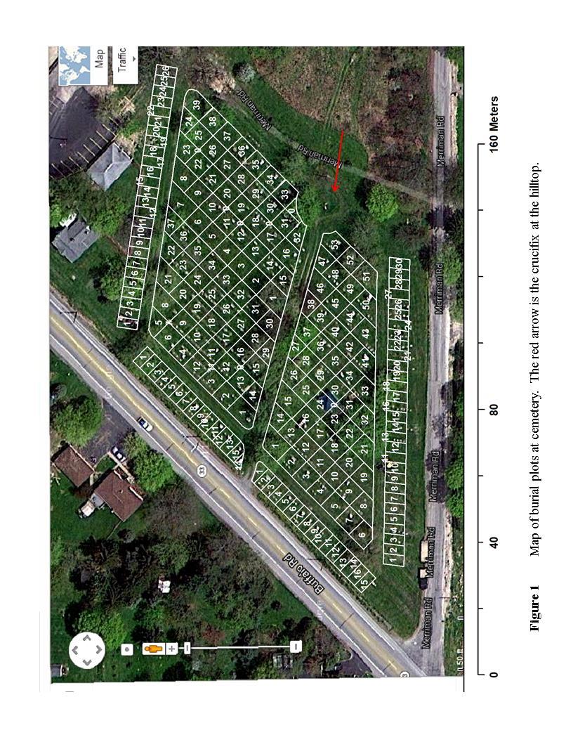
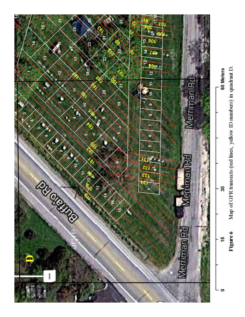
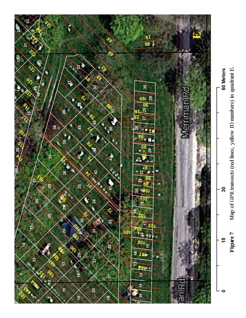
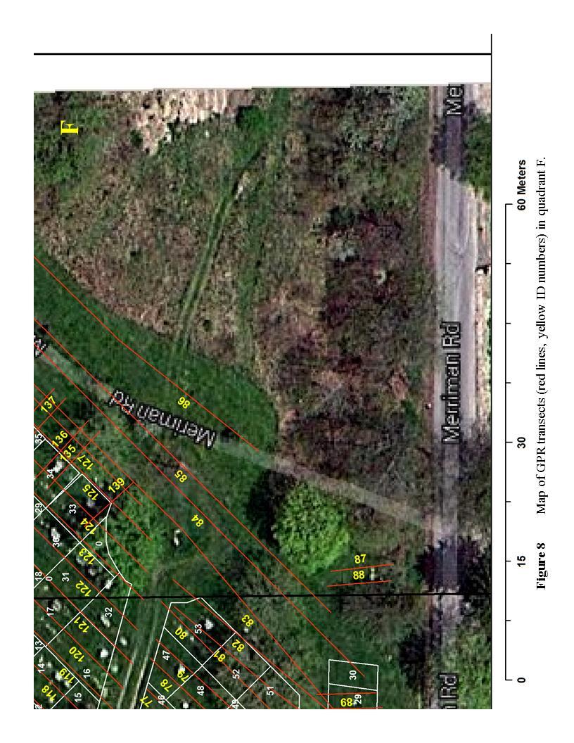
2 Use of Ground Penetrating Radar to identify the presence and orientation of Graves in St. Brigitts Cemetery, Bergen New York By Mike Rodgers and Paul L. Richards Department of Biological and Environmental Science Department of Earth Science The College at Brockport INTRODUCTION The Diocese of St. Brigitts Church in Leroy and Bergen New York are planning to make improvements to St. Brigitts cemetery located at the intersection of Munger Rd and Rte 33 in Bergen, New York. These improvements include the refurbishment of existing head stones, the replacement of headstones where none currently exists, and the identification of land areas where new graves may be located. Like many nineteenth century cemeteries in the area, St. Brigitt cemetery has a long history of burial, and internment procedures have not been consistent over time. Originally, caskets were oriented facing the top of the hill, which is the focal point of the cemetery and the location of a beautiful crucifix. Since then, some caskets have been buried in the opposite direction, thus there is some uncertainty as to where each casket is actually buried. The cemetery is laid out as a series of rectangular and trapezoidal plots around a hill (Figure 1). These plots range in size from 150 to 615 square feet and are located west of the top of the hill. Families and their relatives are often housed within their own plots. As these plots are not completely filled, there is a need to know exactly where the caskets are buried so that descendants may elect to be buried next to their ancestors. The purpose of this study is to determine the location of all caskets buried at the site and their approximate orientation relative to the headstone. This orientation can be either East of the headstone, in which the casket faces the top of the hill, or West of the headstone in which the casket is facing away from the top of the hill. METHODOLOGY Ground Penetrating Radar (GPR) was employed to conduct this study because it has been successfully used for identifying unmarked graves in several previous studies (Conyers, 2006; Fiedler et al, 2009; Ruffell etal, 2009; Doolittle and Bellantoni, 2010). GPR is a non-invasive geophysical technique where pulses of electromagnetic radiation in the microwave band are beamed into the ground. When this radiation reaches a dielectric boundary, any interface where the dielectric characteristics of the materials change appreciably, some of this energy will be reflected. A receiver in the instrument then determines the distance to the boundary based on the time elapsed. By evaluating the spatial distribution of these boundaries, it is possible to identify the location of buried objects, voids and the stratigraphic structure of soil and bedrock. In this application here, we
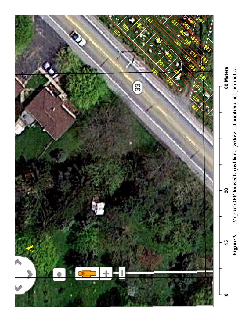
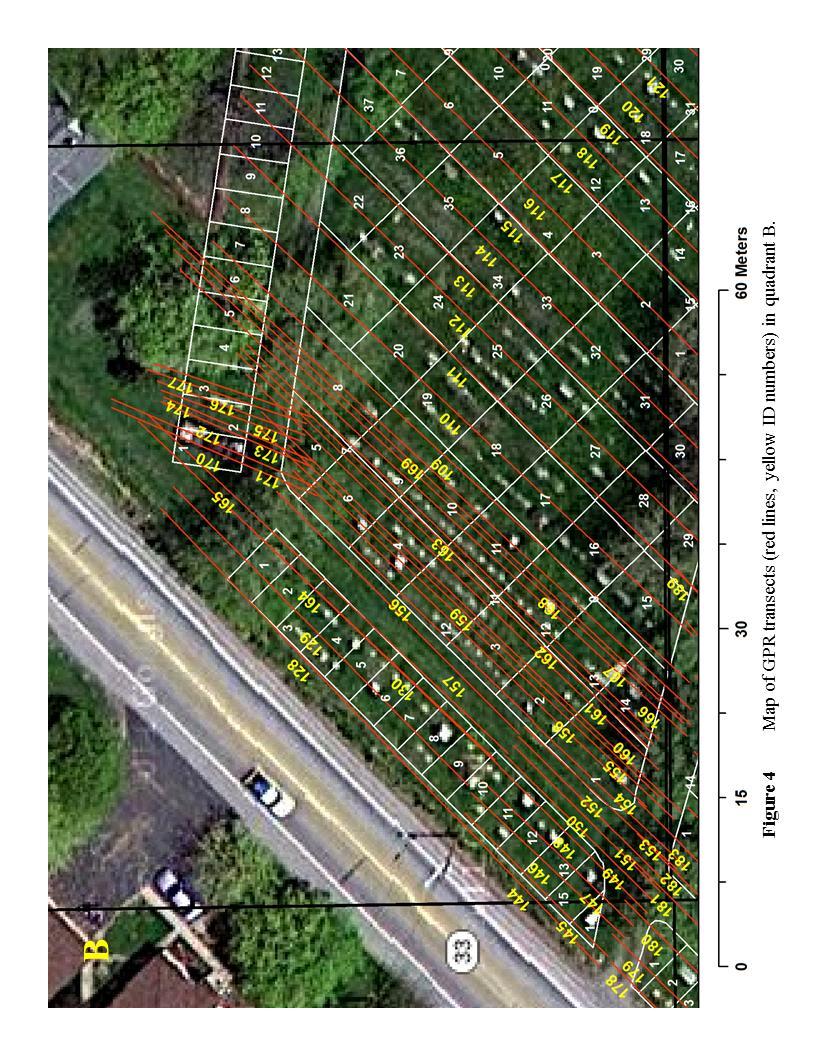
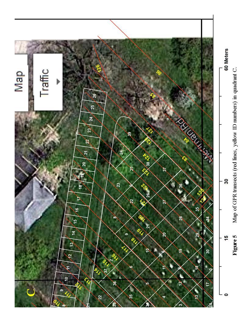
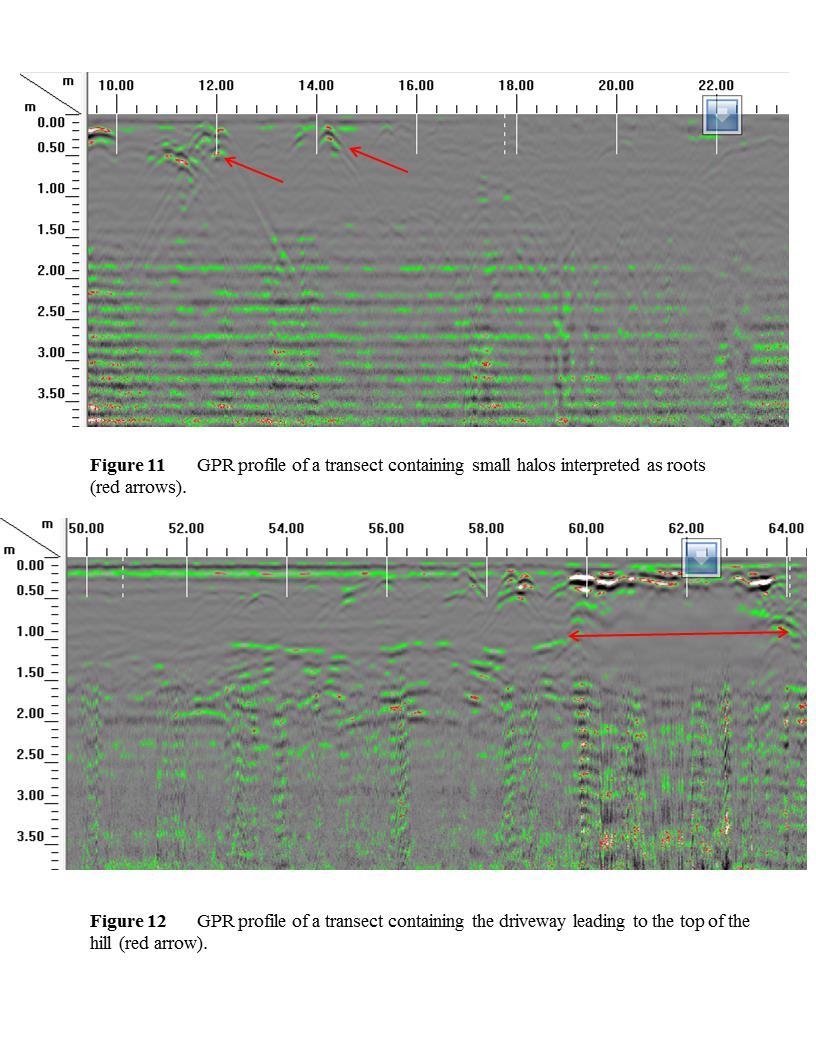
3 are using it to confirm whether or not a buried casket is present. Interpretation was carried out at the site when the data was collected so that supporting field information, such as microtopography, the location of the headstone, the direction the headstone engraving is facing, and the engraving text could be incorporated in the analysis. All anomalies likely to be caskets were marked in the field once they were located. The GPR profiler used in this investigation was a SIR-3000 manufactured by GSSI Inc. A 400 megahertz antenna was used to collect all data. This antenna has a 16 bit resolution and is capable of profiling 3 meters under ideal conditions. A dielectric constant of 8 was assumed to estimate depth from signal response time. This value was determined by iterative estimation in order to reproduce the average depth of the top of a known casket. According to the cemetary caretaker, three feet is the average depth of the top of a casket. Longitudinal distance was evaluated with a survey wheel calibrated to a tape measure. Profiles were conducted in transects East and West of each headstone. Figures 2-8 presents the location of all transects conducted in this study. Interpretations were made by examining the response profile in the field and considering the location, orientation and text on each headstone. Select data was brought back to the lab and processed using RADAN Data Analyzer for Windows version Time zero was adjusted to remove data above the air ground interface. Background signal was eliminated using a mathematical filter. A variety of gains were employed to extract the profile most conducive to interpretation. This was conducted to confirm the interpretation already made in the field. A typical casket is a box made up of wood, metal or concrete. As the box contains air, the sides, top and bottom of the casket reflect RADAR signals strongly. This is because the dielectric contrast between the air and soil are much different (16 versus 1). The casket building material may also play a role in the susceptibility for a signal return. As the antenna is dragged over the site, signals will be returned at different angles creating an upside down U shaped feature in the GPR profile. These features are commonly called Halos in the literature. Soil containing no casket will likely contain signal returns that create a layer-cake profile, which is caused by radar being reflected from soil and clay horizons. Rocks and roots may also be present as small halos in these profiles. RESULTS A typical profile of soil containing caskets is presented in Figure 9. The colors in the profile represent the intensity of the returning radar signal, and vary from low to high in order of the following colors: Dark grey, grey, light grey, green, red and white. Layers of high return intensity (green, red, white) represent changes in dielectric constant, wet or highly conductive layers. Caskets appear as large halos located 0.7 to 1.7 meters depth. Sometimes multiple halos were observed. Older grave sites did not always have large halos associated with them. These however did contain large signal responses at the same depth where halos are located in. Figures present responses from soil that does not contain caskets. The profile in Figure 11 was taken next to a tree which had large roots exposed at the surface. Note the small halos at the top of the profile caused by the roots.
4 Figure 12 was taken through the unpaved road located in the middle of the cemetery. Note the bright, horizontal signal located at the top of the profile. We interpret this to be due to compaction at the top of the profile. This changed the bulk density of the soil enough to cause a dielectric contrast at the top of the profile. Foot and vehicular traffic clearly has an impact on the response of the signal. DISCUSSION The differences in the GPR response between soil containing caskets and soil not containing caskets was pronounced. Large halos are almost always associated in close proximity to headstones. This made it easy to distinguish whether a casket was present. In most cases, associated field information (presence of a shallow depression, and or the orientation of text on the headstone), confirmed the side with which the casket was buried. For example if the text was located on the east side of the headstone, the anomaly (and casket) was buried to the west. There were profiles with large halos located in places where headstones are not present. As they occur in the same corridor as rows with headstones we interpret these to be unmarked graves. These appear to be sites where headstones were moved or removed historically. There also appeared to be a few headstones that have no GPR evidence for a buried casket. At the top of the hill, two of the headstones had caskets that were buried to the south of the headstone, in contrast to all other headstones in the cemetery. This finding makes sense because the people buried there are facing the Crucifix at the top of the hill. The orientation of text on the monument confirms this. Based on the work conducted, there are 432 anomalies that are likely to contain buried caskets. Whether these are single, double or two caskets buried close together are not always possible to determine, because of the variety of radar responses that can be returned. However, profiles with multiple large halos tended to be associated with headstones that indicate two people are buried there. CONCLUSIONS Based on this geophysical survey, there are 432 sites in the cemetery where caskets are buried. These sites have all been marked for the Diocese. There are occurrences of graves without headstones and headstones without graves. Quite a few of the plots still have room for future internments. REFERENCES CITED Conyers, L.B. (2006) Ground-Penetrating Radar Techniques to Discover and Map Historic Graves, Historical Archeology, 40(3), Doolittle, J.A. and Bellantoni, N.F. (2010) The Search for Graves with Ground-Penetrating Radar in Connecticut, Journal of Archeological Science, 37,
5 Fiedler, S., Illich, B., Berger, J., Graw, M. (2009) The effectiveness of ground-penetrating radar surveys in the location of unmarked burial sites in modern cemeteries, Journal of Applied Geophysics, 68, Ruffell A., McCabe, A., Donnelly, C. and Sloan, B. (2009) Location and Assessment of an Historic ( Years Old) Mass Grave Using Geographic and Ground Penetrating Radar Investigation, NW Ireland*, Journal of Forensic Science, 54(2),
6
7
8
9
10
11
12
13
14
15
GROUND PENETRATING RADAR SURVEY OF THE NATHAN ANDERSON CEMETERY, RINGGOLD, GA. Prepared for:
 GROUND PENETRATING RADAR SURVEY OF THE NATHAN ANDERSON CEMETERY, RINGGOLD, GA Prepared for: Marshall Bandy Nathan Anderson Cemetery 15 Nyoka Trail Ringgold, GA 30736 Prepared by: Daniel P. Bigman, PhD
Ground Penetrating Radar Survey of a Portion of East End Cemetery, Cadiz, Kentucky
 Ground Penetrating Radar Survey of a Portion of East End Cemetery, Cadiz, Kentucky January 2011 Report prepared by Anthony L. Ortmann, Ph.D. Assistant Professor Department of Geosciences Murray State University
Geophysical Investigation of a 19th Century Archeological Site, Boston College K. Corcoran, J. Hager, M. Carnevale
 Geophysical Investigation of a 19th Century Archeological Site, Boston College K. Corcoran, J. Hager, M. Carnevale Hager GeoScience, Inc., Waltham, MA ------------------------------------------------------------------------
United States Natural Resources 344 Merrow Road Department of Conservation Service Suite A Agriculture Service Tolland, CT 06084
 United States Natural Resources 344 Merrow Road Department of Conservation Service Suite A Agriculture Service Tolland, CT 06084 SUBJECT: Archaeology Geophysical Field Assistance January 6, 2015 TO: Dr.
COMPARISON OF TWO GPR SURVEYS WITH DIFFERENT GRID SPACINGS TO IDENTIFY UNMARKED GRAVES IN A 19TH CENTURY CEMETERY AT SNYDER COUNTY, PA
 COMPARISON OF TWO GPR SURVEYS WITH DIFFERENT GRID SPACINGS TO IDENTIFY UNMARKED GRAVES IN A 19TH CENTURY CEMETERY AT SNYDER COUNTY, PA Ahmed Lachhab, Associate Professor, Earth and Environmental Sciences
Geophysical Survey of Wisconsin Burial Site BRO-0033 Wixom Cemetery, Rock County, Wisconsin
 Lawrence University Lux Archaeological Reports Anthropology Department 6-2015 Geophysical Survey of Wisconsin Burial Site BRO-0033 Wixom Cemetery, Rock County, Wisconsin Peter N. Peregrine Lawrence University
Hazard Mapping Along the Dead Sea Shoreline
 FIG Working Week in Marrakech, Morocco 18-22 May 2011 Hazard Mapping Along the Dead Sea Shoreline Rami Al-Ruzouq, Abdullah Al-Zuobi, AbdEl-Rahman Abueladas, Emad Akkawi Department of Surveying and Geomatics
Ground Penetrating Radar Survey Report:
 Ground Penetrating Radar Survey Report: Caiphas Burial Tomb Project Israel Data Acquired May 29, 2008 Report compiled June 4, 2008 Survey and Report Published by Mnemotrix Israel, Ltd. Chief GPR Surveyor,
FINAL REPORT GEOPHYSICAL INVESTIGATION WATER TOWER NO. 6 SITE PLANT CITY, FL
 APPENDIX B FINAL REPORT GEOPHYSICAL INVESTIGATION WATER TOWER NO. 6 SITE PLANT CITY, FL Prepared for Madrid Engineering Group, Inc. Bartow, FL Prepared by GeoView, Inc. St. Petersburg, FL February 28,
Council for West Virginia Archaeology Spring Workshop Charleston, West Virginia June 7, 2003
 GEOPHYSICAL DETECTION OF GRAVES BASIC BACKGROUND AND CASE HISTORIES FROM HISTORIC CEMETERIES By William J. Johnson 1 Abstract The identification of graves is an important issue at many historical cemeteries.
The Search for Ancient Helike: a GPR Case Study. Doria L. Kutrubes 1 Radar Solutions International. Steven Soter Smithsonian Institution
 The Search for Ancient Helike: a GPR Case Study Doria L. Kutrubes 1 Radar Solutions International Steven Soter Smithsonian Institution Dora Katsonopoulou American School of Classical Studies at Athens
GPR surveys at Nõmmküla Detection of underground water routes
 GPR surveys at Nõmmküla 2009 Detection of underground water routes Tomi Herronen & Timo Saarenketo 2009 1. Introduction The purpose of this survey was to locate possible underground water routes (rivers)
GPR AS A COST EFFECTIVE BEDROCK MAPPING TOOL FOR LARGE AREAS. Abstract
 GPR AS A COST EFFECTIVE BEDROCK MAPPING TOOL FOR LARGE AREAS Dr. Jutta L. Hager, Hager GeoScience, Inc., Waltham, MA Mario Carnevale, Hager GeoScience, Inc., Waltham, MA Abstract Hager GeoScience, Inc.
GEOPHYSICAL SITE CHARACTERIZATION IN SUPPORT OF HIGHWAY EXPANSION PROJECT
 GEOPHYSICAL SITE CHARACTERIZATION IN SUPPORT OF HIGHWAY EXPANSION PROJECT * Shane Hickman, * Todd Lippincott, * Steve Cardimona, * Neil Anderson, and + Tim Newton * The University of Missouri-Rolla Department
USE OF PRECISION MAPPING AND MULTIPLE GEOPHYSICAL METHODS AT THE HISTORIC REESE CEMETERY IN MUNCIE, INDIANA. Abstract
 USE OF PRECISION MAPPING AND MULTIPLE GEOPHYSICAL METHODS AT THE HISTORIC REESE CEMETERY IN MUNCIE, INDIANA Gregory B. Byer, Mundell & Associates, Inc., Indianapolis, IN John A. Mundell, Mundell & Associates,
Sabal Trail Pipeline Project Evaluation of Karst Topography and Sinkhole Potential for Pipeline and Facilities
 November 11, 2014 Sabal Trail Pipeline Project Evaluation of Karst Topography and Sinkhole Potential for Pipeline and Facilities Gulf Interstate Engineering Attention: Mr. Denys Stavnychyi - Project Engineer
FINAL REPORT GEOPHYSICAL INVESTIGATION VILLAGE ALHAMBRA RETENTION POND SITE THE VILLAGES, FLORIDA
 FINAL REPORT GEOPHYSICAL INVESTIGATION VILLAGE ALHAMBRA RETENTION POND SITE THE VILLAGES, FLORIDA Prepared for Andreyev Engineering, Inc. Oxford, FL Prepared by GeoView, Inc. St. Petersburg, FL August
A GPR ASSESSMENT OF THE PREHISTORIC NAPLES CANAL NAPLES, FLORIDA ARCHAEOLOGICAL AND HISTORICAL CONSERVANCY, INC.
 A GPR ASSESSMENT OF THE PREHISTORIC NAPLES CANAL NAPLES, FLORIDA ARCHAEOLOGICAL AND HISTORICAL CONSERVANCY, INC. AHC TECNICAL REPORT NO. 1004 DECEMBER 2013 A GPR ASSESSMENT OF THE PREHISTORIC NAPLES CANAL
ELECTRICAL RESISTIVITY SURVEY OF INTREPID POTASH INJECTION WELL SITE: EDDY COUNTY, NEW MEXICO
 NCKRI REPORT OF INVESTIGATION 3 ELECTRICAL RESISTIVITY SURVEY OF INTREPID POTASH INJECTION WELL SITE: EDDY COUNTY, NEW MEXICO www.nckri.org NATIONAL CAVE AND KARST RESEARCH INSTITUTE REPORT OF INVESTIGATION
Sabal Trail Pipeline Project Evaluation of Karst Topography and Sinkhole Potential for Pipeline and Facilities
 November 11, 2014 Sabal Trail Pipeline Project Evaluation of Karst Topography and Sinkhole Potential for Pipeline and Facilities Gulf Interstate Engineering Attention: Mr. Denys Stavnychyi - Project Engineer
GPR SURVEYS AT SOME 700 YEARS-OLD STRUCTURES IN THE OLD CITY OF CAIRO, EGYPT.
 GPR SURVEYS AT SOME 700 YEARS-OLD STRUCTURES IN THE OLD CITY OF CAIRO, EGYPT. Mohamed G. El-Behiry Geophysics Department, Faculty of Science, Cairo University, Giza, Egypt. Abstract Remediation and restoration
Grave Concerns Point Lookout Rd Park Hall, MD NCPTT and Jahn Certified
 October 8, 2007 Mr. and Mrs. Griffith Harrison 7123 Dryburgh Court Springfield, Virginia 22152 Ref: CA-002-001 Report of the Harrison Cemetery Restoration Dear Mr. and Mrs. Harrison Please find enclosed
Geophysics for Environmental and Geotechnical Applications
 Geophysics for Environmental and Geotechnical Applications Dr. Katherine Grote University of Wisconsin Eau Claire Why Use Geophysics? Improve the quality of site characterization (higher resolution and
PHASE 1 STUDIES UPDATE EROSION WORKING GROUP
 PHASE 1 STUDIES UPDATE EROSION WORKING GROUP Presented By MICHAEL WOLFF, PG Erosion Study Area Manager West Valley Demonstration Project Quarterly Public Meeting February 24, 2016 OUTLINE Study 1 Terrain
IDENTIFICATION OF UNMARKED GRAVES AT TWO HISTORIC CEMETERIES IN GEORGIA
 Identification of Unmarked Graves at Two Historic Cemeteries Thieme 257 IDENTIFICATION OF UNMARKED GRAVES AT TWO HISTORIC CEMETERIES IN GEORGIA by Donald M. Thieme (Valdosta State University, Department
Mapping the Dead. By: Sharon Mollick, GISP Assistant Planner Cumberland County Department of Planning & Development Bridgeton, New Jersey USA
 Mapping the Dead By: Sharon Mollick, GISP Assistant Planner Cumberland County Department of Planning & Development Bridgeton, New Jersey 08302 USA Abstract The Old Cohansey Baptist Cemetery, located in
THE UTILITY OF HORIZONTAL COMPONENT MEASUREMENTS IN RANDOM-WALK TEM SURVEYS. Abstract
 THE UTILITY OF HORIZONTAL COMPONENT MEASUREMENTS IN RANDOM-WALK TEM SURVEYS Norman R. Carlson, Zonge Engineering & Research Organization, Inc., Tucson, AZ Kenneth L. Zonge, Zonge Engineering & Research
In 1998, salvage archaeological investigations began on the bank of the Miami River
 1 Imaging Sub-surface Features of the Miami Circle with Ground Penetrating Radar Jessie Pincus a, Robert S. Carr b, Dean Whitman c Ground Penetrating Radar (GPR) is a high-resolution near-surface geophysical
Mitigation of Gypsum Mine Voids Under SR-2 in Ottawa County, Ohio
 Subsurface Investigation and Conceptual Alternatives Mitigation of Gypsum Mine Voids Under SR-2 in Ottawa County, Ohio Presented By: Ohio Department of Transportation CH2M HILL CTL Engineering Technos,
P60 High Resolution Geophysics Inside Machado de Castro Museum - Coimbra, Centre Portugal
 P60 High Resolution Geophysics Inside Machado de Castro Museum - Coimbra, Centre Portugal C. Grangeia (University of Aveiro), M.J. Senos Matias* (University of Aveiro), F. Figueiredo (University of Coimbra),
Detecting Buried Human Bodies Using Ground-Penetrating Radar
 Earth Science Research; Vol. 5, No. 2; 2016 ISSN 1927-0542 E-ISSN 1927-0550 Published by Canadian Center of Science and Education Detecting Buried Human Bodies Using Ground-Penetrating Radar Widodo 1,
Prairie View A&M University Cemetery. By Rene DeLaFuente, Tammy Oldani, Stacey Rogers
 Prairie View A&M University Cemetery By Rene DeLaFuente, Tammy Oldani, Stacey Rogers Objective Complete the plotting of all headstones in the modern cemetery, including Total Station data and photographs,
Comparison of geophysical. techniques to determine depth to. bedrock in complex weathered. environments of the Mount Crawford. region, South Australia
 Comparison of geophysical techniques to determine depth to bedrock in complex weathered environments of the Mount Crawford region, South Australia Thesis submitted in accordance with the requirements of
JOURNAL(OF(THE( ANTHROPOLOGICAL(SOCIETY(OF( SOUTH(AUSTRALIA( (!!!! Special!Edition! Archaeological!Science!!!!! VOLUME!35!!JULY!2012!!!!! EDITORS!
 JOURNALOFTHE ANTHROPOLOGICALSOCIETYOF SOUTHAUSTRALIA SpecialEdition ArchaeologicalScience VOLUME35 JULY2012 EDITORS Amy$Roberts$and$F.$Donald$Pate$ JOURNALOFTHEANTHROPOLOGICALSOCIETYOFSOUTHAUSTRALIA GeophysicalInvestigationsoftheTabernacle
The Following was Noted: US Army Corps of Engineers Philadelphia District Geotechnical Section, CENAP-EN-DG
 US Army Corps of Engineers Philadelphia District Geotechnical Section, CENAP-EN-DG Wanamaker Bldg, 7th Floor 100 Penn Square East Philadelphia, PA 19107-3396,USA Site Visit Report Date: Tuesday, Nov. 6,
KARST MAPPING WITH GEOPHYSICS AT MYSTERY CAVE STATE PARK, MINNESOTA
 KARST MAPPING WITH GEOPHYSICS AT MYSTERY CAVE STATE PARK, MINNESOTA By Todd A. Petersen and James A. Berg Geophysics Program Ground Water and Climatology Section DNR Waters June 2001 1.0 Summary A new
Although most karstic regions
 Urban Geophysics: Geophysical Signature of Mount Bonnell Fault and Its Karstic Features in Austin, TX by Mustafa Saribudak, Environmental Geophysics Associates, Austin, TX Although most karstic regions
The response of ground penetrating radar (GPR) to changes in temperature and moisture condition of pavement materials
 to changes in temperature and moisture condition of pavement materials") Loughborough University Institutional Repository The response of ground penetrating radar (GPR) to changes in temperature and moisture condition of pavement materials This item was submitted to Loughborough
Loughborough University Institutional Repository The response of ground penetrating radar (GPR) to changes in temperature and moisture condition of pavement materials This item was submitted to Loughborough
High Resolution Geophysics: A Better View of the Subsurface. By John Jansen, P.G., Ph.D., Aquifer Science and Technology
 High Resolution Geophysics: A Better View of the Subsurface By John Jansen, P.G., Ph.D., Aquifer Science and Technology Geologist Use Only Part of the Information Available To Them Most Geologist rely
Use of Geophysical Software for Interpretation of Ice-Penetrating Radar Data and Mapping of Polar Ice Sheets
 Use of Geophysical Software for Interpretation of Ice-Penetrating Radar Data and Mapping of Polar Ice Sheets Alex O. Martinez University of Kansas 2335 Irving Hill Road Lawrence, KS 66045-7612 http://cresis.ku.edu
B029 2D and 3D Resistivity Imaging in an Investigation of Boulder Occurrence and Soil Depth in Glacial Till
 B029 2D and 3D Resistivity Imaging in an Investigation of Boulder Occurrence and Soil Depth in Glacial Till R. Wisen* (Lund University), F. Linders (Lund University) & T. Dahlin (Lund University) SUMMARY
THE USE OF GEOMATICS IN CULTURAL HERITAGE AND ARCHAEOLOGY FOR VARIOUS PURPOSES
 THE USE OF GEOMATICS IN CULTURAL HERITAGE AND ARCHAEOLOGY FOR VARIOUS PURPOSES FEBRUARY 2013 AL BEIDA GEOPLAN CONTENT Company Profile Concept Objectives and Strategies Data Production Methods Data Samples
ELECTRICAL RESISTIVITY SURVEYS AT THE ANDERSON RESIDENCE SITE, PORT CLYDE, ME. For: St.Germain-Collins
 ELECTRICAL RESISTIVITY SURVEYS AT THE ANDERSON RESIDENCE SITE, PORT CLYDE, ME For: St.Germain-Collins 4 Union Street, Suite 3 Bangor, Maine 441 July, 218 ELECTRICAL RESISTIVITY SURVEYS AT THE ANDERSON
M E M O R A N D U M. Mr. Jonathan K. Thrasher, P.E. and Mr. Ian Kinnear, P.E. PSI
 M E M O R A N D U M TO: FROM: Mr. Mark Schilling Gulf Interstate Engineering Mr. Jonathan K. Thrasher, P.E. and Mr. Ian Kinnear, P.E. PSI DATE: November 11, 2014 RE: Summary of Findings Geotechnical Study
 SHEET TITLE: DRAWN BY: J.M.CLARK FILE NO. CHECKED BY: W.S. JORDAN APPROVED BY: DATE: FIGURE SHEET TITLE: DRAWN BY: J.M.CLARK FILE NO. CHECKED BY: W.S. JORDAN APPROVED BY: DATE: FIGURE SPOTLIGHT Technical
APPENDIX C GEOPHYSICAL REPORT
 APPENDIX C GEOPHYSICAL REPORT GEOPHYSICAL ENGINEERING SURVEY REPORT 700 E 241 st Street NOVA PROJECT NUMBER 15-0522 DATED January 27, 2015 PREPARED FOR: LANGAN Long Warf Maritime Center New Haven, CT 06511
MINNESOTA DEEP TEST PROTOCOL PROJECT
 MINNESOTA DEEP TEST PROTOCOL PROJECT Mn/DOT Agreement No. 85878 OSA License No. 04-030 Authorized and Sponsored by: MINNESOTA DEPARTMENT OF TRANSPORTATION FEDERAL HIGHWAY ADMINISTRATION Prepared by COMMONWEALTH
Available online Journal of Scientific and Engineering Research, 2016, 3(2):1-7. Research Article
:1-7. Research Article") Available online www.jsaer.com, 2016, 3(2):1-7 Research Article ISSN: 2394-2630 CODEN(USA): JSERBR Assessment of the Reliability of Magnetic Method to Delineate Geologic Features in a Basement Complex:
Available online www.jsaer.com, 2016, 3(2):1-7 Research Article ISSN: 2394-2630 CODEN(USA): JSERBR Assessment of the Reliability of Magnetic Method to Delineate Geologic Features in a Basement Complex:
Geotechnical verification of impact compaction
 PII-73 Geotechnical verification of impact compaction P. J. Waddell1, R. A. Moyle2 & R. J. Whiteley1 1 2 Coffey Geotechnics, Sydney, Australia Coffey Geotechnics, Harrogate, UK Abstract Remediation of
The Estimation of Buried Pipe Diameters by Generalized Hough Transform of Radar Data
 Progress In Electromagnetics Research Symposium 2005, Hangzhou, China, August 22-26 345 The Estimation of Buried Pipe Diameters by Generalized Hough Transform of Radar Data C. G. Windsor 1, L. Capineri
IMAGING OF DEEP SINKHOLES USING THE MULTI-ELECTRODE RESISTIVITY IMPLANT TECHNIQUE (MERIT) CASE STUDIES IN FLORIDA
 CASE STUDIES IN FLORIDA") IMAGING OF DEEP SINKHOLES USING THE MULTI-ELECTRODE RESISTIVITY IMPLANT TECHNIQUE (MERIT) CASE STUDIES IN FLORIDA David Harro The G3 Group, 2509 Success Drive, Suite 1, Odessa, FL 33556, david.harro@geo3group.com
IMAGING OF DEEP SINKHOLES USING THE MULTI-ELECTRODE RESISTIVITY IMPLANT TECHNIQUE (MERIT) CASE STUDIES IN FLORIDA David Harro The G3 Group, 2509 Success Drive, Suite 1, Odessa, FL 33556, david.harro@geo3group.com
A Survey of St Michael and All Angels Churchyard Hamstall Ridware
 Project No 6 A Survey of St Michael and All Angels Churchyard by M R Holland Annie Saunders MA March 2003 Table of Contents Introduction Methods Acknowledgements Appendix A Geophysics 3 3 5 6 Table of
ACQUISITION, PROCESSING AND INTERPRETATION TECHNIQUES FOR GROUND-PENETRATING RADAR MAPPING OF BURIED PIT-STRUCTURES IN THE AMERICAN SOUTHWEST
 ACQUISITION, PROCESSING AND INTERPRETATION TECHNIQUES FOR GROUND-PENETRATING RADAR MAPPING OF BURIED PIT-STRUCTURES IN THE AMERICAN SOUTHWEST Lawrence B. Conyers Deparunent of Anthropology, University
cultural resource analysts, inc.
 October 28, 2016 Mr. David Alley Alley Realty and Auction, Inc. 2099 Thunderhead Road, Suite 204 Knoxville, Tennessee 37923 Office: (865) 584-5791 Cell: (865) 389-7361 RE: A Ground-Penetrating Radar Survey
Foundation pile and cavity detection by the 3D directional borehole radar system, ReflexTracker
 Foundation pile and cavity detection by the 3D directional borehole radar system, ReflexTracker K. Wada, S. Karasawa, K. Kawata, T. Ueki Matsunaga Geo-survey Co., Ltd. 1-23-1 Ooi, 140-0014, Tokyo, Japan
Virtual Georadar Modelling of Significant Archaeological Sites
 Geophysical Prospecting 1 Anna Klochko Dmitry Shishkov Virtual Georadar Modelling of Significant Archaeological Sites Abstract: 3D modelling of archaeological sites and historical objects with non-destructive
How Nefertiti s Tomb Should Appear on Radar
 How Nefertiti s Tomb Should Appear on Radar By Glen Dash Glen Dash Foundation for Archaeological Research 1 [Revision of October 26, 2015] Between 2008 and 2011, in support of Dr. Zahi Hawass expedition
Case Study: University of Connecticut (UConn) Landfill
 Landfill") Case Study: University of Connecticut (UConn) Landfill Problem Statement:» Locate disposal trenches» Identify geologic features and distinguish them from leachate and locate preferential pathways in fractured
Case Study: University of Connecticut (UConn) Landfill Problem Statement:» Locate disposal trenches» Identify geologic features and distinguish them from leachate and locate preferential pathways in fractured
A GPR ASSESSMENT OF THE NAPLES CANAL 8CR59: PHASE II NAPLES, FLORIDA ARCHAEOLOGICAL AND HISTORICAL CONSERVANCY, INC.
 A GPR ASSESSMENT OF THE NAPLES CANAL 8CR59: PHASE II NAPLES, FLORIDA ARCHAEOLOGICAL AND HISTORICAL CONSERVANCY, INC. AHC TECNICAL REPORT NO. 1023 JUNE 2014 A GPR ASSESSMENT OF THE NAPLES CANAL 8CR59: PHASE
Monitoring Report No. 022 GREENCASTLE BURIALS GREEN CASTLE COUNTY DOWN LICENCE NO. N/A PHILIP MACDONALD
 Monitoring Report No. 022 GREENCASTLE BURIALS GREEN CASTLE COUNTY DOWN LICENCE NO. N/A PHILIP MACDONALD Monitoring Report No. 022 Greencastle Burials (SMR No. Down 057:017) Greencastle Co. Down Philip
3-D ground-penetrating radar surveys on a frozen river lagoon
 3-D ground-penetrating radar surveys on a frozen river lagoon Monica Moldoveanu and Robert R. tewart ABTRACT Ground-penetrating radar (GPR) surveys were acquired at Bowness Park, Calgary to characterize
General Editor: Vince Russett
 YCCCART 2014/Y20 North Somerset HER 2015/11 Manual survey using an electronic, hydryostatic level (NIVCOMP) at Wemberham Roman Villa YATTON, CONGRESBURY, CLAVERHAM AND CLEEVE ARCHAEOLOGICAL RESEARCH TEAM
Wheldon View, Wheldon Road, Castleford West Yorkshire
 Wheldon View, Wheldon Road, Castleford West Yorkshire An Archaeological Evaluation for Exemplar plc by Sarah Coles Thames Valley Archaeological Services Ltd Site Code WWC03/23 March 2003 Summary Site name:
Ronin Placer Ground-penetrating Radar Survey Report
 Ronin Placer Ground-penetrating Radar Survey Report Tenures: 837095, 837097 Mining Division: Greenwood NTS Location: 082E/03 Geographic Center Coordinates: UTM Zone 11, E 345340, N 5438730 Claims Owner:
Ronin and Dayton Placer Ground-penetrating Radar Survey Report
 Ronin and Dayton Placer Ground-penetrating Radar Survey Report Tenures: 837095, 837097, 889865, 890187 Mining Division: Greenwood NTS Location: 082E/03 Geographic Center Coordinates: UTM Zone 11, E 345340,
Starting at Rock Bottom: A Peculiar Central Texas PreClovis Culture
 Starting at Rock Bottom: A Peculiar Central Texas PreClovis Culture Background Brushy Creek grades, overall, west-northwest (WNW) to east-southeast (ESE) through the easternmost portions of the central
Ground Penetrating Radar (GPR) Mapping as a Method for Planning Excavation Strategies, Petra, Jordan
 Mapping as a Method for Planning Excavation Strategies, Petra, Jordan") Society for American Archaeology http://mysite.du.edu/~lconyer/petra/index.html Ground Penetrating Radar (GPR) Mapping as a Method for Planning Excavation Strategies, Petra, Jordan LAWRENCE B CONYERS 1,
Society for American Archaeology http://mysite.du.edu/~lconyer/petra/index.html Ground Penetrating Radar (GPR) Mapping as a Method for Planning Excavation Strategies, Petra, Jordan LAWRENCE B CONYERS 1,
GPR and bulk ground resistivity surveys in graveyards: locating. aschool of Physical Sciences & Geography, Keele University, Keele,
 1 2 GPR and bulk ground resistivity surveys in graveyards: locating unmarked burials in contrasting soil types 3 4 James D. Hansena, Jamie K. Pringlea* & Jon Goodwinb 5 6 7 8 9 aschool of Physical Sciences
Facilities and Recreation Department Cemetery Division
 Facilities and Recreation Department Cemetery Division A Pictorial Essay and Guide to the inner workings of the Forest Hill Cemetery Derry, New Hampshire Welcome to Forest Hill Cemetery. The Cemetery is
ARCHAEO-GEOPHYSICAL INVESTIGATION OF THE EMMANUEL A.M.E. CHURCH AND FORMER GLASGOW STREET LOCATION OF THE CHURCH PORTSMOUTH, VIRGINIA
 Prepared for: Drs. Cassandra Newby-Alexander and Jeffery Littlejohn Norfolk State University Brown Hall C 156 700 Park Avenue Norfolk, Virginia 23504 (757) 823-8984 ARCHAEO-GEOPHYSICAL INVESTIGATION OF
Evaluation/Monitoring Report No. 259
 SITE 100M EAST OF 16 LEARMORE ROAD CASTLEGORE CASTLEDERG COUNTY TYRONE LICENCE NO.: AE/13/36E NAOMI CARVER 1 Site Specific Information Site Name: 100m east of 16 Learmore Road, Castlederg, Co. Tyrone Townland:
TRC1504: Alternative Uses of Ground Penetrating Radar in Highway in Construction and Maintenance. Elisha Wright-Kehner, P.E.
 TRC1504: Alternative Uses of Ground Penetrating Radar in Highway in Construction and Maintenance Elisha Wright-Kehner, P.E. Why GPR? Practicality Non-invasive (Non-destructive Testing - NDT) Real-time
Shock Effects in CML 0175: The Wow Stone
 PSU McNair Scholars Online Journal Volume 3 Issue 1 Identity, Communities, and Technology: On the Cusp of Change Article 17 2009 Shock Effects in CML 0175: The Wow Stone Kristy Hauver Portland State University
Geophysical Case studies From Texas
 Geophysical Case studies From Texas 1 PRESENTATION OUTLINE Active Growth Faults in Metropolitan Houston 1. Hockley 2. Tomball 3. Long Point 4. Pearland Foundation Case Studies Karst Geophysics in Austin:
ambiguity in earth sciences IESO Geophysics Section Eddy hartantyo, Lab Geofisika FMIPA UGM
 ambiguity in earth sciences IESO Geophysics Section Eddy hartantyo, Lab Geofisika FMIPA UGM Pelatihan Tahap II IESO Teknik Geologi UGM Februari 2009 1 Introduction Photos from http://www.eegs.org/whatis/
Geophysics for Land Development
 Geophysics for Land Development About Us Whatever your area of interest GBGMAPS can provide advanced subsurface and structural geophysical solutions to add value to your product. Mining and infrastructure
Applied Geophysics for Environmental Site Characterization and Remediation
 Applied Geophysics for Environmental Site Characterization and Remediation MSECA Webinar September 24, 2015 John Mundell, P.E., L.P.G. Ryan Brumbaugh, L.P.G. MUNDELL & ASSOCIATES, INC. Webinar Objective
Georadar Application for Dam Safety Study (Case Study of Selorejo Dam)
") The 2 nd International Seminar on Science and Technology 155 Georadar Application for Dam Safety Study (Case Study of Selorejo Dam) Teguh Winari 1, Kamsiyah Windianita 1, and Fahmi Hidayat 1 Abstract Selorejo
The 2 nd International Seminar on Science and Technology 155 Georadar Application for Dam Safety Study (Case Study of Selorejo Dam) Teguh Winari 1, Kamsiyah Windianita 1, and Fahmi Hidayat 1 Abstract Selorejo
Three different types of ground penetrating radar (GPR) were used on. separate occasions during the research period. The timing of each survey,
 were used on. separate occasions during the research period. The timing of each survey,") Ground Penetrating Radar Three different types of ground penetrating radar (GPR) were used on separate occasions during the research period. The timing of each survey, type of GPR used and the graves on
Ground Penetrating Radar Three different types of ground penetrating radar (GPR) were used on separate occasions during the research period. The timing of each survey, type of GPR used and the graves on
GPR profiling and electrical resistivity tomography for buried cavity detection: a test site at the Abbaye de l'ouye (France)
") GPR profiling and electrical resistivity tomography for buried cavity detection: a test site at the Abbaye de l'ouye (France) Nerouz BOUBAKI, Albane SAINTENOY, Piotr TUCHOLKA IDES - UMR 8148 CNRS, Université
GPR profiling and electrical resistivity tomography for buried cavity detection: a test site at the Abbaye de l'ouye (France) Nerouz BOUBAKI, Albane SAINTENOY, Piotr TUCHOLKA IDES - UMR 8148 CNRS, Université
UNCONVENTIONAL DEEP-WATER GPR INVESTIGATION OF DRILLING OBSTRUCTIONS. Abstract
 UNCONVENTIONAL DEEP-WATER GPR INVESTIGATION OF DRILLING OBSTRUCTIONS Jutta Hager, Hager GeoScience, Inc., Woburn, MA Mario Carnevale, Hager GeoScience, Inc., Woburn, MA Brian R. Jones, Hager GeoScience,
Prediction of Areas Sensitive to Fertilizer Application in Thinly-Soiled Karst
 Prediction of Areas Sensitive to Fertilizer Application in Thinly-Soiled Karst Paul L. Richards, Jill Libby, Alex Kuhl, Tim Daniluk, Mike Lyzwa with contribution by the theses of Sarah Rhinehart, Cal Payne,
Use of Non-Invasive Near-Surface Geophysics for Managing Brine Releases
 Use of Non-Invasive Near-Surface Geophysics for Managing Brine Releases Presented by: Brent W. Barker, Staff Geophysicist Remediation Technologies Symposium 2012 Imagine the result Co-Authors Boyce L.
POTENTIAL USE OF GROUND PENETRATING RADAR IN HIGHWAY ROCK CUT STABILITY Norbert H. Maerz* and Wooyoung Kim^ ABSTRACT INTRODUCTION
 Geophysics 2000, Dec. 11-15, 2000, St. Louis, MO, 9 pp. POTENTIAL USE OF GROUND PENETRATING RADAR IN HIGHWAY ROCK CUT STABILITY Norbert H. Maerz* and Wooyoung Kim^ *Rock Mechanics and Explosives Research
New Sunday School, St Mary s Church, White Waltham, Maidenhead, Berkshire
 New Sunday School, St Mary s Church, White Waltham, Maidenhead, Berkshire An Archaeological Evaluation for White Waltham and Shottesbrook Parochial Church Council by Simon Cass Thames Valley Archaeological
EXTREMELY FAST IP USED TO DELINEATE BURIED LANDFILLS. Norman R. Carlson, Cris Mauldin Mayerle, and Kenneth L. Zonge
 EXTREMELY FAST IP USED TO DELINEATE BURIED LANDFILLS Norman R. Carlson, Cris Mauldin Mayerle, and Kenneth L. Zonge Zonge Engineering and Research Organization, Inc. 3322 East Fort Lowell Road Tucson, Arizona,
Geology 228/378 Applied and Environmental Geophysics. Lecture 14 Ground Penetrating Radar (GPR)
") Geology 228/378 Applied and Environmental Geophysics Lecture 14 Ground Penetrating Radar (GPR) Outline Ground Penetrating Radar (GPR) 1. GPR System 2. Fundamental principles 3. Coupled with the media:
Geology 228/378 Applied and Environmental Geophysics Lecture 14 Ground Penetrating Radar (GPR) Outline Ground Penetrating Radar (GPR) 1. GPR System 2. Fundamental principles 3. Coupled with the media:
APPENDIX A GLOSSARY. Appendix A.1
 APPENDIX A GLOSSARY Appendix A.1 Appendix A.2 Back Bearing A back bearing is measured from the object to your position. It is the exact opposite of a direct bearing. Base Line An imaginary line on the
Geoarchaeology and Geophysics at Feltus
 Geoarchaeology and Geophysics at Feltus Sarah C. Sherwood (Department of Anthropology, University of the South, Sewanee) Bryan S. Haley (Center for Archaeological Research, University of Mississippi) Jay
Northamptonshire Archaeology
 Northamptonshire Archaeology Archaeological Geophysical Survey At Sulgrave Castle Green, Sulgrave, Northamptonshire August 2007 Adrian Butler November 2007 Report 07/192 Northamptonshire Archaeology 2
Ground-Penetrating Radar
 7 Ground-Penetrating Radar Lawrence B. Conyers Ground-penetrating radar (GPR) has recently gained a wide acceptance in the archaeological community as a method that can quickly and accurately locate buried
Natural stone assessment with ground penetrating radar (GPR)
") Natural stone assessment with ground penetrating radar (GPR) The 15th Meeting of the Association of European Geological Societies 16 20 September 2007 Tallinn, Estonia Hannu Luodes 18.9.2007 1 Location
Natural stone assessment with ground penetrating radar (GPR) The 15th Meeting of the Association of European Geological Societies 16 20 September 2007 Tallinn, Estonia Hannu Luodes 18.9.2007 1 Location
Ground subsidence is a worldwide problem especially
 Ground Engineering: GPR A Case Study on Ground Subsidence Using Ground Penetrating Radar Nur Azwin Ismail and Rosli Saad Geophysics Section, School of Physics, Universiti Sains Malaysia Ground subsidence
Supplementary material: Methodological annex
 1 Supplementary material: Methodological annex Correcting the spatial representation bias: the grid sample approach Our land-use time series used non-ideal data sources, which differed in spatial and thematic
The fields of application of the Ground Penetrating Radar (GPR) are: CONSTRUCTION APPLICATIONS
 are: CONSTRUCTION APPLICATIONS") I.Industrial (technical) applications of geophysical methods used by the Archeo-geophysics laboratory in construction, plumbing, geotechnical engineering, engineering geology, mining, electricity power
I.Industrial (technical) applications of geophysical methods used by the Archeo-geophysics laboratory in construction, plumbing, geotechnical engineering, engineering geology, mining, electricity power
Name Date Class _. Please turn to the section titled The Nature of Light.
 Please turn to the section titled The Nature of Light. In this section, you will learn that light has both wave and particle characteristics. You will also see that visible light is just part of a wide
UTC R189 GEOPHYSICAL ASSESSMENT OF KARST ACTIVITY. Neil L. Anderson
 GEOPHYSICAL ASSESSMENT OF KARST ACTIVITY by Neil L. Anderson UTC R189 A University Transportation Center Program at Missouri University of Science & Technology Disclaimer The contents of this report reflect
Geophysical prospection and aerial photography in La Laguna, Tlaxcala, Mexico
 ArcheoSciences Revue d'archéométrie 33 (suppl.) 2009 Mémoire du sol, espace des hommes Geophysical prospection and aerial photography in La Laguna, Tlaxcala, Mexico Luis Barba, Jorge Blancas, Agustin Ortiz
Ground Penetrating Radar & By Mike Kelty Western Technologies Inc.
 Ground Penetrating Radar & Thermorgraphy By Mike Kelty Western Technologies Inc. Overview Types of Locating Methods/Equipment How GPR Works GPR Applications How Thermography Works Thermography Applications
AVALANCHE VICTIM SEARCH BY GROUND PENETRATING RADAR. Christian Jaedicke * Norwegian Geotechnical Institute, Oslo, Norway
 AVALANCHE VICTIM SEARCH BY GROUND PENETRATING RADAR Christian Jaedicke * Norwegian Geotechnical Institute, Oslo, Norway ABSTRACT: Ground penetrating radar (GPR) systems are used in many applications of