Vietnam Coastal Erosion - Cause and Challenges -
|
|
|
- Jonah Mitchell
- 5 years ago
- Views:
Transcription
1 Administration of Sea and Islands Center for Oceanography University of Transport and Communications, Hanoi Vietnam Vietnam Coastal Erosion - Cause and Challenges - Presenters: Pham Hoang KIEN Le Van CONG Vu Tien THANH Hanoi-2018

")

2 Introduction Area 331,690 km 2 Population 95.9 million (2018) Population Density 226 persons/km 2 Percent Urban 20.8% Percent Rural 79.2%
3 Introduction Vietnam is a coastal state with more than 3,000 islands Coastline is of more than 3,260 km in length including 28 coastal province and cities Vietnamese sea area covers more than 1 million km² (three times larger than its land area)
4 Socio - Economics Over 50% of Vietnam s major cities are coastal cities and 31% national population settling down. GDP of marine and coastal economy accounts for 48% GDP in 2010 (NWMST, 2011). Sea and coastal play an important role in Vietnam s economy
5 Present status of Vietnam coastal erosion
6 Present status of erosion along North Vietnam coastline Cliffs, low rock coasts and low foreshore with limestone, gravel, sand, lay and mud. Accretion: 50-60m in river mouths (Cu et al., 2000) beside strong erosion far from river mouths In Quang Ninh province Coastline region is relatively stable but erosion takes place at short coastal sections Red - Thai Binh river delta coast has been rather complicated with alternate accretion and erosion Fig 1. Vietnam Coastline and marine region map Erosion occurred seriously continuously at Nam Dinh and Cat Hai (Hai Phong)
7 Coastal erosion areas in North Vietnam coastal provinces Province Eroded area (ha) Quang Ninh Hai Phong Thai Binh Nam Dinh Ninh Binh - Source: The Final report of project KC (2005)


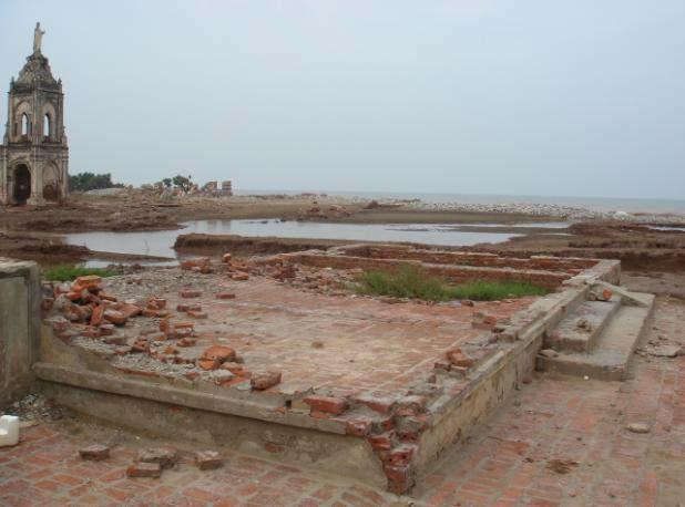

8 Coastal erosion in Nam Dinh province

9 TC21 field trip to Hai Hau District, Nam Dinh Province
10 Present status of erosion along Central Vietnam coastline Coastal sand-banks and bay beach, mountain form coastal cliffs and rock shores Erosion predominates with a high concentration of sand and low fraction of mud and clay More than 40% of the eroded sectors are of more than 1 km in length Fig 1. Vietnam Coastline and marine region map 10.6% of the coast has eroded 200 m or more inland.
11 The number of eroded sectors (according to length) Province Erosion sectors (m) < >6000 Thanh Hoa Nghe An Ha Tinh Quang Binh Quang Tri Quang Nam Thua Thien Hue Da Nang Quang Ngai Khanh Hoa Phu Yen Ninh Thuan Binh Thuan Total Source: The final report of project KC (2005)

12 Example of Erosion: Evolution of Cua Dai Coast Source: Google Earth


13 Erosion in Cua Dai river mouth
14 Present status of erosion along South Vietnam coastline Mud and clay. Mangroves develop in low-lying stretch. Cliff are formed close to the shore causing the absence of beaches Since 1960 erosion has happened quite commonly in South delta provinces From there are 10 additional eroded shore sections during Northeast and Southeast monsoon Coastal erosion threatens the embankment works and residential areas Fig 1. Vietnam Coastline and marine region map
15 Accretion-erosion status of South Vietnam coastal estuary (ha) Province Accretion Erosion Accretion or Erosion (-) Ho Chi Minh Tien Giang Ben Tre Tra Vinh Soc Trang Bac Lieu Ca Mau Kien Giang Source: Project KC.09.05


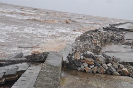
16 Erosion broke down embarkment in Ganh Hao (Bac Lieu province)
17 Factors influencing coastal erosion
18 Factors influencing coastal erosion Physical factors: Geology: coastal sediments are made up of un consolidated sand and gravel Wave and currents: are impacted strongly by two monsoon seasons (NE and SW) Tropical cyclones: 60% number of storms that affect Vietnam s marine zone devasting Vietnam Storm surge: interact with waves causing coastal erosion
19 Factors influencing coastal erosion Human factors: Embankment: causes the loss of coastal sediment and erosion will occur Irrigation works at upstream: affected the river flow regime and reduce amount of sediment transported to the sea Mining: destroy natural structure of the coast Mangrove deforestation: reduce functions in limiting wind storms and wave

20 Factors influencing coastal erosion
21 Measures for Mitigation of Erosion

22 Measures for Mitigation of Erosion Structure Aim to protect beach and coastline from the impact of dynamic coastal processes: Permanent structures: dam or dykes Soft structures: geotube or wave and wind-breaking plants Non-structure Communication education and raising awareness to the population about the hazards of natural disasters and the major reasons of erosion and accretion Policies and Various laws such as Law on Environmental Protection, etc.
23 Relevant Laws and Policies for addressing coastal erosion in Vietnam In 1946, Vietnam has established management agencies and legislation on dikes as protection measures such as the Central Committee on Dyke Protection and the Committees on Dyke Protection at various levels Since 1990, a number of specialized organizations and legislation to direct and guide the implementation of disaster control measures have been founded. New policies on the construction and renovation of coastal dykes and embankments, planting and restoration of mangroves, penalties for violations of dyke and land laws But no distinct legislation or institutional office that deals specifically with the management of and countermeasures against coastal erosion

24 Example of pilot project on erosion mitigation in Vietnam The locations selected for pilot project was based on the list of national key areas for coastal erosion. The selected area should match the goals which aims to solve both the urgent, immediate problems, and the overall, long-term issues, contributing to the development of long-term coastal socio-economic sustainability. Location of pilot project


")
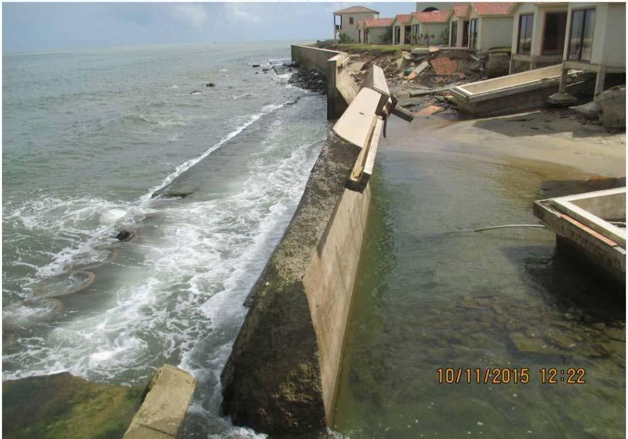
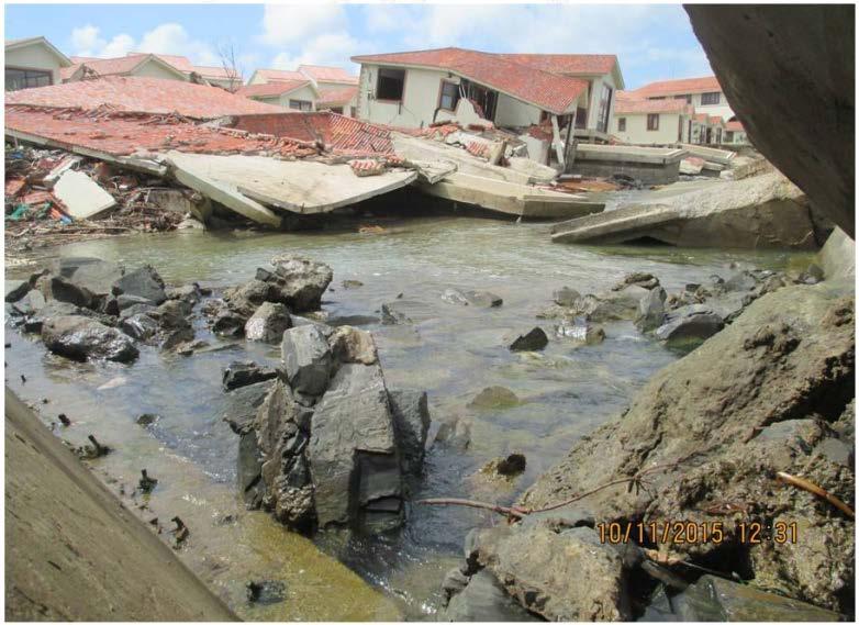
25 Coast was eroded by Mindule typhoon at Quang Cu commune, Thanh Hoa province (8/2010) Coast was eroded by Mangkhut typhoon at Quang Cu commune (8/2013)
26 Main points of pilot project Evaluation of coastal erosion resolution: the existing problems, efficiency, challenges, plans and policies, scientific and social issues related to coastal erosion resolution. Investigation of the actual erosion causes: assessment of factors contributing to coastal erosion. Development of the coastal vulnerability maps: coastal erosion status and risk warning maps; and a coastal erosion database. Conferences to disseminate knowledge regarding disaster prevention, coastal ecosystems protection and sustainable development. New planting mangroves and casuarina forest as wave and wind barriers. Support for repair/construction of damaged dykes by using friendly environmetal technology such as sandbags and geotute. Proposed resolution strategies for coastal erosion: policy, science and technology and community-based solutions.


27 Erosion in Hau Loc district (Thanh Hoa province) and embankment reconstruction
28 Recomendations Efficient coastal erosion prevention: coordinated and comprehensive measures, structural and non-structural measures. It is necessary to value non-structural measures such as communication, education and raising awareness to the population including understanding of the laws. The national and regional development planning should include the issue of coastal erosion and define appropriate responding measures. It is also necessary to strengthen of the legal framework, plan coastal protection against over-exploitation of natural resources. Policy should plan for permanent relocation from danger zone, temporary relocation in case of warning and urgent relocation in case of emergency.
Current Status of Vietnam Coastal Erosion and Major Measures for Mitigation
 Vietnam Administration of Sea and Islands Center for Oceanography University of Transport and Communications Current Status of Vietnam Coastal Erosion and Major Measures for Mitigation Case Study: Thanh
Proposal for Research and Investment Activities in the Coast and Estuaries (A Case Study in the North Central Coast of Viet Nam)
") 2017/SOM3/EPWG/019 Agenda Item: 7.2.3 Proposal for Research and Investment Activities in the Coast and Estuaries (A Case Study in the North Central Coast of Viet Nam) Purpose: Information Submitted by:
2017/SOM3/EPWG/019 Agenda Item: 7.2.3 Proposal for Research and Investment Activities in the Coast and Estuaries (A Case Study in the North Central Coast of Viet Nam) Purpose: Information Submitted by:
STATUS OF COASTAL EROSION OF VIETNAM AND PROPOSED MEASURES FOR PROTECTION
 STATUS OF COASTAL EROSION OF VIETNAM AND PROPOSED MEASURES FOR PROTECTION Assoc. Prof., Dr. Assoc. Prof., Dr. Prof., DSc. Eng. Ngo Ngoc Cat Pham Huy Tien Do Dinh Sam Nguyen Ngoc Binh The coastal zone of
THE MODEL OF SPATIAL ORGANIZATION OF COASTAL FISHERMEN VILLAGES IN THE SOUTH CENTRAL COAST OF VIETNAM
 i MINISTRY OF EDUCATION AND TRAINING MINISTRY OF CONSTRUCTION HANOI ARCHITECTURAL UNIVERSITY TRAN VAN HIEN THE MODEL OF SPATIAL ORGANIZATION OF COASTAL FISHERMEN VILLAGES IN THE SOUTH CENTRAL COAST OF
HEAVY RAIN OVER MID-CENTRAL REGION OF VIETNAM
 HEAVY RAIN OVER MID-CENTRAL REGION OF VIETNAM ----------------------------------------------------------------------- S.Eng. Dang Thi Mai; Dr. Nguyen Thi Tan Thanh National Hydro Meteorological Service
CLIMATE CHANGE IN VIET NAM: Observed and Future Projection
 2017 ACTS Workshop on Extreme Weather Forecast and Water Resources Management CLIMATE CHANGE IN VIET NAM: Observed and Future Projection Mai Van KHIEM Viet Nam Institute of Meteorology, Hydrology and Climate
Populations effected by flood top ten districts
 2050 - Populations effected by flood top ten districts 14 Extreme A2 Extreme A2 with dyke District Area (Ha) Population 2050 People affected Percent area affected People affected Percent area affected
RISK OF TYPHOON AND STORM SURGES IN COASTAL AREAS OF VIETNAM
 RISK OF TYPHOON AND STORM SURGES IN COASTAL AREAS OF VIETNAM Hoang Duc Cuong, Nguyen Ba Thuy, Nguyen Van Huong, Du Duc Tien Vietnam National Center for Hydro-meteorological Forecasting (NCHMF) Hanoi, 26-27
2014 Summer training course for slope land disaster reduction Taipei, Taiwan, Aug
 MINISTRY OF SCIENCE AND TECHNOLOGY HYDROTECH RESEARCH INSTITUTE MINISTRY OF NATURAL RESOURCES AND ENVIRONMENT VIETNAM INSTITUTE OF GEOSCIENCES AND MINERAL RESOURCES (VIGMR) 2014 Summer training course
SIMULATION OF A WORST CASE TSUNAMI SCENARIO FROM THE MANILA TRENCH TO VIETNAM
 SIMULATION OF A WORST CASE TSUNAMI SCENARIO FROM THE MANILA TRENCH TO VIETNAM Nguyen Hong Phuong, Vu Ha Phuong, Pham The Truyen Earthquake Information and Tsunami Warning Centre, VAST OUTLINE Earthquake
Updating a medium-scale landslide database for high-risk areas using community surveys in Vietnam
 On-going program of the State-Funded Landslide Project (SFLP): Updating a medium-scale landslide database for high-risk areas using community surveys in Vietnam Coordinated by: Le Quoc Hung, Pham Van Son,
Hydraulic modelling for flood vulnerability assessment, case study in river basins in North Central Vietnam
 Hydraulic modelling for flood vulnerability assessment, case study in river basins in North Central Vietnam Tran Ngoc Anh 1*,2, Dang Dinh Kha 1,2, Dang Dinh Duc 2, Nguyen Thanh Son 1 1 Faculty of Hydrology
Scientific bases for defining the coastal zone of Quang Binh, Quang Tri, Thua Thien Hue provinces
 VNU Journal of Science, Earth Sciences 26 (2010) 8-18 Scientific bases for defining the coastal zone of Quang Binh, Quang Tri, Thua Thien Hue provinces Nguyen Hieu*, Nguyen Cao Huan, Dang Van Bao Hanoi
Recent development of the National Hydro-Meteorological Service (NHMS) of Viet Nam for disaster risk reduction
 of Viet Nam for disaster risk reduction") Ministry of Natural Resources and Environment National Hydro-Meteorological Service Recent development of the National Hydro-Meteorological Service (NHMS) of Viet Nam for disaster risk reduction Tran Van
Ministry of Natural Resources and Environment National Hydro-Meteorological Service Recent development of the National Hydro-Meteorological Service (NHMS) of Viet Nam for disaster risk reduction Tran Van
RESPONSE TO TYPHOON HAIYAN IN VIET NAM
 RESPONSE TO TYPHOON HAIYAN IN VIET NAM Dr. Nguyen Dai Khanh Mr. Vo Van Hoa ESCAP/WMO typhoon Committee 8 th IWS/2 nd TRCG Forum Ma Cau, 02-06 December 2013 Introduction TY Haiyan-1330 In the morning 04/11,
A Mapping of Pond Aquaculture, Mangroves and Coastal Wetlands in Vietnam, Cambodia, Thailand and Myanmar in 1999 and Comparison to 2014
 Aquaculture and Coastal Habitats Report No. 5 A Mapping of Aquaculture, s and Coastal Wetlands in Vietnam, Cambodia, Thailand and Myanmar in and Comparison to 2014 J. Ronald Eastman, James Toledano, Stefano
Investigation, assessment and warning zonation for landslides in the mountainous regions of Vietnam
 Investigation, assessment and warning zonation for landslides in the mountainous regions of Vietnam (State-Funded Landslide Project SFLP) Dr. Eng. Le Quoc Hung Add: 67 Chien Thang Street, Ha Dong District,
MINISTRY OF NATURAL RESOURCES AND ENVIRONMENT
 MINISTRY OF NATURAL RESOURCES AND ENVIRONMENT HÀ NỘI, 2016 CLIMATE CHANGE AND SEA LEVEL RISE SCENARIOS FOR VIET NAM SPM Summary for policymakers Main authors: Tran Thuc, Nguyen Van Thang, Huynh Thi Lan
E2993 v4. Background on Natural Disaster. Environmental Assessment (EA) Viet Nam Managing Natural Hazards Project (VN-Haz/WB5) ANNEX 4
 Viet Nam Managing Natural Hazards Project (VN-Haz/WB5) ANNEX 4") Public Disclosure Authorized Public Disclosure Authorized Public Disclosure Authorized Public Disclosure Authorized Environmental Assessment (EA) ANNEX 4 Background on Natural Disaster 1. This annex presents
Public Disclosure Authorized Public Disclosure Authorized Public Disclosure Authorized Public Disclosure Authorized Environmental Assessment (EA) ANNEX 4 Background on Natural Disaster 1. This annex presents
MEMBER REPORT. ESCAP/WMO Typhoon Committee 10 th IWS SOCIALIST REPUBLIC OF VIET NAM
 MEMBER REPORT ESCAP/WMO Typhoon Committee 10 th IWS SOCIALIST REPUBLIC OF VIET NAM October 2015 CONTENTS I. Overview of tropical cyclones which have affected/impacted Member s area since the last Typhoon
HCMC CLIMATE CHANGE IMPACT AND ADAPTATION ADB/HCMC PPC. Director ICEM International Centre for Environmental Management
 HCMC CLIMATE CHANGE IMPACT AND ADAPTATION STUDY ADB/HCMC PPC Jeremy Carew-Reid Jeremy Carew-Reid Director ICEM International Centre for Environmental Management Adaptation planning capacity 2 Increasing
EXISTING SHORELINE, SEA DYKE, AND SHORE PROTECTION WORKS IN THE LOWER MEKONG DELTA, VIETNAM AND ORIENTED SOLUTIONS FOR STABILITY
 EXISTING SHORELINE, SEA DYKE, AND SHORE PROTECTION WORKS IN THE LOWER MEKONG DELTA, VIETNAM AND ORIENTED SOLUTIONS FOR STABILITY Dinh Cong San 1, Tang Duc Thang 2, Le Manh Hung 1 1 Center for River training
ANALYSIS OF CHANGES IN THE RIVERBANKS OF MEKONG RIVER - VIETNAM BY USING MULTI-TEMPORAL REMOTE SENSING DATA
 ANALYSIS OF CHANGES IN THE RIVERBANKS OF MEKONG RIVER - VIETNAM BY USING MULTI-TEMPORAL REMOTE SENSING DATA Lam Dao Nguyen a, Nguyen Thanh Minh a, Pham Thi Mai Thy b, Hoang Phi Phung a and Hoang Van Huan
EVALUATION OF THE VULNERABILITY OF TitleCOASTAL SOCIO-NATURAL SYSTEMS (EXAM FROM KHANH HOA COASTAL ZONE) Author(s) Nguyen, Thi Thuy Hang; Pham, Hung T
 Author(s) Nguyen, Thi Thuy Hang; Pham, Hung T") EVALUATION OF THE VULNERABILITY OF TitleCOASTAL SOCIO-NATURAL SYSTEMS (EXAM FROM KHANH HOA COASTAL ZONE) Author(s) Mai, Trong Nhuan; Tran, Thanh Hai; Nguyen, Thi Thuy Hang; Pham, Hung T Annual Report of
EVALUATION OF THE VULNERABILITY OF TitleCOASTAL SOCIO-NATURAL SYSTEMS (EXAM FROM KHANH HOA COASTAL ZONE) Author(s) Mai, Trong Nhuan; Tran, Thanh Hai; Nguyen, Thi Thuy Hang; Pham, Hung T Annual Report of
Term Knowledge Using and applying Grade Criteria Autumn 1 Assessment window October Natural hazards pose major risks to people and property.
 Assessment Schedule Year 9 2015/6 Term Knowledge Using and applying Grade Criteria Autumn 1 Assessment window October 2015 3.1.1.2 Tectonic Natural hazards pose major risks to people and property. Definition
Coastal Protection Strategies for the Red River Delta
 Journal of Coastal Research 25 1 105 116 West Palm Beach, Florida January 2009 Coastal Protection Strategies for the Red River Delta Cong V. Mai, Marcel J.F. Stive, and Pieter H.A.J.M. Van Gelder Faculty
East Asia & Southeast Asia region
 Deltas at Risk Dynamics and vulnerability of river delta system East Asia & Southeast Asia region Yoshiki Saito Geological Survey of Japan Huanghe (Yellow River) Plateau Tibetan Himalayas Old Huanghe (500
ME KONG RIVER COMMISSION FLASH FLOOD GUIDANCE SYSTEM (MRCFFGS)
") NATIONAL HYDRO-METEOROLOGICAL SERVICE IN VIETNAM NATIONAL CENTER FOR HYDRO-METEOROLOGICAL FORECASTING ME KONG RIVER COMMISSION FLASH FLOOD GUIDANCE SYSTEM (MRCFFGS) http://www.nchmf.gov.vn 29 Nov 1 Dec
NATIONAL HYDRO-METEOROLOGICAL SERVICE IN VIETNAM NATIONAL CENTER FOR HYDRO-METEOROLOGICAL FORECASTING ME KONG RIVER COMMISSION FLASH FLOOD GUIDANCE SYSTEM (MRCFFGS) http://www.nchmf.gov.vn 29 Nov 1 Dec
Assessment of climate change impacts on salinity intrusion in Hong-Thai Binh and Dong Nai river basins
 VNU Journal of Science, Earth Sciences 27 (2011) 54-61 Assessment of climate change impacts on salinity intrusion in Hong-Thai Binh and Dong Nai river basins Tran Hong Thai, Tran Thi Van* Vietnam Institute
Monitoring Coastal Change after the Tsunami in Thailand
 IOP Conference Series: Earth and Environmental Science OPEN ACCESS Monitoring Coastal Change after the Tsunami in Thailand To cite this article: W Pantanahiran 2014 IOP Conf. Ser.: Earth Environ. Sci.
Development of Modeling System to Simulate Hydrodynamic and Environmental Quantities in the Hai Phong Estuary, Vietnam
 34 th IAHR World Congress - Balance and Uncertainty 6 June - 1 July 011, Brisbane, Australia 33 rd Hydrology & Water Resources Symposium 10 th Hydraulics Conference Development of Modeling System to Simulate
Huong River. Serial No. : Viet Nam-8 Location: Thua Thien Hue Province, Viet Nam N 16 00' '
 Viet Nam 8 Huong River Map of River Table of Basic Data Name: Huong River Serial No. : Viet Nam-8 Location: Thua Thien Hue Province, Viet Nam N 16 00' - 14 40' E 107 07' - 107 50' 2 Area: 2,830 km Length
Optical Remote Sensing Method for Detecting Urban Green Space as Indicator Serving City Sustainable Development
 Proceedings Optical Remote Sensing Method for Detecting Urban Green Space as Indicator Serving City Sustainable Development Tran Thi Van *, Nguyen Dang Huyen Tran, Ha Duong Xuan Bao, Dinh Thi Thanh Phuong,
VNREDSat-1. Vietnam Natural Resources, Environment and Disaster monitoring Satellite. Lai Anh Khoi SPACE TECHNOLOGY INSTITUTE
 VNREDSat-1 Vietnam Natural Resources, Environment and Disaster monitoring Satellite Lai Anh Khoi SPACE TECHNOLOGY INSTITUTE JPTM2014 Yangon, Nov. 19-21, 2014 General information (1) Project Owner: Vietnam
EROSION MECHANISM OF NGA BAY RIVERBANKS, HO CHI MINH CITY, VIETNAM
 EROSION MECHANISM OF NGA BAY RIVERBANKS, HO CHI MINH CITY, VIETNAM Abstract Bui Trong Vinh 1, Nguyen Hai Truong 1 1 Department of Geo-Environment, Faculty of Geology and Petroleum Engineering Ho Chi Minh
GIS for Saving Lives in Vietnam Use and Applications of GIS and RS for Disaster Management in Vietnam
 GIS for Saving Lives in Vietnam Use and Applications of GIS and RS for Disaster Management in Vietnam Dr. Hoang Minh Hien Disaster Management Center, Vietnam & Vu Ngoc Chau Ministry of Agriculture and
Establishing the Method for Assessing Flood Vulnerability in Ho Chi Minh City, Vietnam A Case Study in District 6
 Journal of Environmental Science and Engineering B 7 (2018) 72-82 doi:10.17265/2162-5263/2018.02.005 D DAVID PUBLISHING Establishing the Method for Assessing Flood Vulnerability in Ho Chi Minh City, Vietnam
New GCSE Geography AQA
 Learning Checklist Half Term 1 26 th September 3 rd October 10 th October 17 th October 1.1.1 Tectonic Hazards Plate tectonics theory. Global distribution of earthquakes and volcanic eruptions and their
THE MEKONG DELTAIC COAST: PAST, PRESENT AND FUTURE MORPHOLOGY
 Erasmus Mundus MSc Programme Coastal and Marine Engineering and Management CoMEM THE MEKONG DELTAIC COAST: PAST, PRESENT AND FUTURE MORPHOLOGY Phan Khanh Linh ID number: 4125347 Delft University of Technology
Mangrove Erosion in the Mekong delta
 Mangrove Erosion in the Mekong delta 1. Introduction a. Mangrove coast - a balance between different forcing factors Mangroves are coastal environments frequently observed in the tropical muddy coasts.
Situation, causes and solutions for coastal protection and restoration of coastal mangroves in the Mekong Delta
 Situation, causes and solutions for coastal protection and restoration of coastal mangroves in the Mekong Delta Le Manh Hung 1, Tran Ba Hoang 2 1,2 Southern Institute of Water Resource Research, Ho Chi
International Symposium on Natural Disaster Mitigation. Local vulnerability assessment of landslides and debris flows
 International Symposium on Natural Disaster Mitigation of landslides and debris flows Lessons learnt from Cam Pha town and Van Don district, Quang Ninh province, Vietnam Nguyen Quoc Phi Faculty of Environment
Using Reanalysis SST Data for Establishing Extreme Drought and Rainfall Predicting Schemes in the Southern Central Vietnam
 Using Reanalysis SST Data for Establishing Extreme Drought and Rainfall Predicting Schemes in the Southern Central Vietnam Dr. Nguyen Duc Hau 1, Dr. Nguyen Thi Minh Phuong 2 National Center For Hydrometeorological
Coastal Inundation Forecasting Demonstration Project CIFDP. Flood Forecasting Initiative-Advisory Group (FFI-AG 3), Geneva, 5-7 Dec, 2017
, Geneva, 5-7 Dec, 2017") Coastal Inundation Forecasting Demonstration Project CIFDP Flood Forecasting Initiative-Advisory Group (FFI-AG 3), Geneva, 5-7 Dec, 2017 Coastal Flooding & Vulnerable Populations Coastal populations are
Coastal Inundation Forecasting Demonstration Project CIFDP Flood Forecasting Initiative-Advisory Group (FFI-AG 3), Geneva, 5-7 Dec, 2017 Coastal Flooding & Vulnerable Populations Coastal populations are
SCIENTIFIC BACKGROUND
 SCIENTIFIC BACKGROUND I. VITAE PROFILE Full name: NGUYEN THI THUC ANH Date of birth: March st, 96 Home town: Hoa Xuan Dong, Dong Hoa district, Phu Yen province Work: Work Address: Home Adress Sex: Female
Monitoring Urban Space Expansion Using Remote Sensing Data in Ha Long City, Quang Ninh Province in Vietnam
 Monitoring Urban Space Expansion Using Remote Sensing Data in Ha Long City, Quang Ninh Province in Vietnam MY Vo Chi, LAN Pham Thi, SON Tong Si, Viet Key words: VSW index, urban expansion, supervised classification.
Nguyen Hoang Khanh Linh, Le Ngoc Phuong Quy, Truong Do Minh Phuong and Nguyen Trac Ba An
 Journal of Agricultural Science and Technology A and B & Hue University Journal of Science 7 (2017) 48-59 doi: 10.17265/2161-6256/2017.10.007S D DAVID PUBLISHING Application of Remote Sensing and GIS Technology
Controlling Processes That Change Land
 1 Name Date Controlling Processes That Change Land People try to control some of the processes that change land. To do this, people apply technology- the use of science to solve problems in everyday life.
26 Coastal erosion and accretion
 26 Coastal erosion and accretion 26.1 Rate of erosion and accretion 26.2 Length of protected coastline 26.3 Volume of sand nourishment Fig. 26.1: Coastline dynamics of the South East Baltic region Key
Mapping Landslide Events in Vietnam Using the Global Landslide Catalog and GIS
 Mapping Landslide Events in Vietnam Using the Global Landslide Catalog and GIS Minh NGUYEN DINH, Huong NGUYEN, Vietnam Key words: mapping, landslide events, Vietnam, global landslide catalog, GIS SUMMARY
Proceeding Optical Remote Sensing Method for Detecting Urban Green Space as Indicator Serving City Sustainable Development
 Proceeding Optical Remote Sensing Method for Detecting Urban Green Space as Indicator Serving City Sustainable Development Tran Thi Van *, Nguyen Dang Huyen Tran, Ha Duong Xuan Bao, Dinh Thi Thanh Phuong,
Bhutan Country Report for JPTM 2010 (July, 2010) Department of Disaster Management Ministry of Home & Cultural Affairs Royal Government of Bhutan
 Department of Disaster Management Ministry of Home & Cultural Affairs Royal Government of Bhutan") Bhutan Country Report for JPTM 2010 (July, 2010) Department of Disaster Management Ministry of Home & Cultural Affairs Royal Government of Bhutan 1 Contents of Presentation 1. Disaster Hazards and Underlying
Bhutan Country Report for JPTM 2010 (July, 2010) Department of Disaster Management Ministry of Home & Cultural Affairs Royal Government of Bhutan 1 Contents of Presentation 1. Disaster Hazards and Underlying
Newsletter # 2. Pilot sites in Greece. December 2018
 A HarmonizEd framework to Mitigate coastal EroSion promoting ICZM protocol implementation Newsletter # 2 December 2018 View of a beach in Ammolofi ( Paggaio Municipality ) Pilot sites in Greece 1. Name
Hong Phuong TRINH, Thi Minh An NGO, Thi Thanh Thuy HOANG, Viet Nam
 Using remote sensing technology to detect the shoreline change caused by mining activities: case study of Thach Khe iron mine, Thanh Ha district, Ha Tinh province, Viet Nam This is a Peer Reviewed Paper
INTEGRATED ASSESSMENT OF RISK LEVEL Title BY HAZARDS IN THE COASTAL ZONE OF V (CASES STUDY : CAM RANH-PHAN RI COA ZONE)
") INTEGRATED ASSESSMENT OF RISK LEVEL Title BY HAZARDS IN THE COASTAL ZONE OF V (CASES STUDY : CAM RANH-PHAN RI COA ZONE) Author(s) Mai, Trong Nhuan; Nguyen, Tai Tue; Tran, Dang Quy; Nguyen, Thi Hoang H
INTEGRATED ASSESSMENT OF RISK LEVEL Title BY HAZARDS IN THE COASTAL ZONE OF V (CASES STUDY : CAM RANH-PHAN RI COA ZONE) Author(s) Mai, Trong Nhuan; Nguyen, Tai Tue; Tran, Dang Quy; Nguyen, Thi Hoang H
Paper Reference. Paper Reference(s) 1312/4H Edexcel GCSE Geography A Higher Tier. Monday 11 June 2007 Afternoon Time: 1 hour 15 minutes
 1312/4H Edexcel GCSE Geography A Higher Tier. Monday 11 June 2007 Afternoon Time: 1 hour 15 minutes") Centre No. Paper Reference Surname Initial(s) Candidate No. 1 3 1 2 4 H Signature Paper Reference(s) 1312/4H Edexcel GCSE Geography A Higher Tier Paper 4H Monday 11 June 2007 Afternoon Time: 1 hour 15
Centre No. Paper Reference Surname Initial(s) Candidate No. 1 3 1 2 4 H Signature Paper Reference(s) 1312/4H Edexcel GCSE Geography A Higher Tier Paper 4H Monday 11 June 2007 Afternoon Time: 1 hour 15
Public Disclosure Copy. Implementation Status & Results Report Vietnam: Project for Improved Land Governance and Databases (VILG) (P154387)
 (P154387)") Public Disclosure Authorized EAST ASIA AND PACIFIC Vietnam Social, Urban, Rural and Resilience Global Practice Global Practice IBRD/IDA Investment Project Financing FY 2017 Seq No: 4 ARCHIVED on 07-Dec-2017
Public Disclosure Authorized EAST ASIA AND PACIFIC Vietnam Social, Urban, Rural and Resilience Global Practice Global Practice IBRD/IDA Investment Project Financing FY 2017 Seq No: 4 ARCHIVED on 07-Dec-2017
LESSONS FROM TYPHOON NARI
 LESSONS FROM TYPHOON NARI Storm Resistant Housing Shown To Be Effective Tran Van Giai Phong, Technical Lead ISET-Vietnam LESSONS FROM TYPHOON NARI 1 LESSONS FROM TYPHOON NARI Storm Resistant Housing Shown
Wainui Beach Management Strategy (WBMS) Summary of Existing Documents. GNS Tsunami Reports
 Summary of Existing Documents. GNS Tsunami Reports") Wainui Beach Management Strategy (WBMS) Summary of Existing Documents GNS Tsunami Reports a) Review of Tsunami Hazard and Risk in New Zealand ( National Risk Report ) b) Review of New Zealand s Preparedness
Wainui Beach Management Strategy (WBMS) Summary of Existing Documents GNS Tsunami Reports a) Review of Tsunami Hazard and Risk in New Zealand ( National Risk Report ) b) Review of New Zealand s Preparedness
Sri Lanka has a coastline of km excluding the shoreline of bays and inlets.
 Defining and Demarcating Coastal zones in Sri Lanka Procedure, Challenges and What needs to be done? Dr. Anil Premaratne Director General Coast Conservation Coast Conservation Department Sri Lanka 1 Sri
GENERAL. CHAPTER 1 BACKGROUND AND PURPOSE OF THE GUIDELINES Background of the Guidelines Purpose of the Guidelines...
 GENERAL CHAPTER 1 BACKGROUND AND PURPOSE OF THE GUIDELINES... 1 1.1 Background of the Guidelines... 1 1.2 Purpose of the Guidelines... 3 CHAPTER 2 APPLICATION OF THE GUIDELINES... 3 2.1 Potential Users
Author(s) Issue Date Text Version publisher. DOI. rights
 Issue Date Text Version publisher. DOI. rights") Title Author(s) Citation MPACT OF SEA LEVEL RSE ON COASTAL RESOURCE N VETNAM Tran Nghi; Mai Trong Nhuan; Dang Van Luyen; Chu Van Ngo; Nguyen Thanh Lan; Dam Quang Minh; Pham Duc Quang Annual Report of FY
Title Author(s) Citation MPACT OF SEA LEVEL RSE ON COASTAL RESOURCE N VETNAM Tran Nghi; Mai Trong Nhuan; Dang Van Luyen; Chu Van Ngo; Nguyen Thanh Lan; Dam Quang Minh; Pham Duc Quang Annual Report of FY
NAG2015 International Seminar, 20 August 2015, Hanoi, Vietnam Numerical Analysis in Geotechnics
 NAG2015 International Seminar, 20 August 2015, Hanoi, Vietnam Numerical Analysis in Geotechnics ORGANIZED BY Vietnamese Society for Soil Mechanics & Geotechnical Engineering (VSSMGE), Vietnam Thuyloi University
CHAPTER 6 CLIMATE AND CLIMATE - RELATED DISASTER PROFILE OF HA TINH
 CHAPTER 6 CLIMATE AND CLIMATE - RELATED DISASTER PROFILE OF HA TINH 6.1. Introduction This Chapter provides background climatic data for Ha Tinh, as a prelude to the climate change scenarios and vulnerability
Chapter 21 Southwest Asia: Harsh & Arid Lands
 Name Hour Chapter 21 Southwest Asia: Harsh & Arid Lands Essential Question: How has the physical geography of Asia influenced the development of these regions (i.e. history, population distribution, &
PHOTOGRAMMETRY AND GIS TECHNOL 1 OGIES FOR MONITORING COASTAL EROSION ALONG DAR ES SALAAM COASTLINE. By: Z.Y Masele, S.D Mayunga1.
 PHOTOGRAMMETRY AND GIS TECHNOL 1 OGIES FOR MONITORING COASTAL EROSION ALONG DAR ES SALAAM COASTLINE. By: Z.Y Masele, S.D Mayunga1 Abstract Dar Es salaam coastline is seriously suffering from coastal soil
SOCIALIST REPUBLIC OF VIET NAM COUNTRY REPORT
 SOCIALIST REPUBLIC OF VIET NAM COUNTRY REPORT ESCAP / WMO 40 TH SESSION OF THE TYPHOON COMMITTEE Macao, China, 21-26 November 2007 NATIONAL HYDRO-METEOROLOGICAL SERVICE CONTENTS I. Overview of Meteorological
Geography GCSE. Year 9 Term and Topic Unit Content Homework Opportunities
 Geography GCSE Year 9 Term and Topic Unit Content Homework Opportunities Autumn Term 1: Geographical Skills Autumn Term 2: Tectonic Hazards Spring Term 1: Ecosystems Rainforest Students are required to
Flood Hazard Vulnerability Mapping Using Remote Sensing and GIS: A Case Study of Surat Dhruvesh KM 1*, Praful MU 2 and Aditya MV 1 1
 Flood Hazard Vulnerability Mapping Using Remote Sensing and GIS: A Case Study of Surat Dhruvesh KM 1*, Praful MU 2 and Aditya MV 1 1 CU Shah University, Wadhwan, India 2 ISTAR-CVM, Vallabh Vidyanagar,
Disaster Prevention and Management in Asia: The Context of Human Security and Its Relevance to Infrastructure Planning and Management
 Disaster Prevention and Management in Asia: The Context of Human Security and Its Relevance to Infrastructure Planning and Management Rajib Shaw http://www.iedm.ges.kyoto-u.ac.jp/ Contents Background and
Disaster Risk Management in India. Kamal Kishore New Delhi, 27 October 2016
 Disaster Risk Management in India Kamal Kishore New Delhi, 27 October 2016 Hazard, Exposure and Vulnerability Disaster Prevention Mitigation Hurricane Matthew: Cuba & Haiti Emergency Response Coordination
Geol 117 Lecture 18 Beaches & Coastlines. I. Types of Coastlines A. Definition:
 I. Types of Coastlines A. Definition: 1. Shore = narrow zone where ocean meets land (e.g. beach) 2. Coast is a broad area where both ocean and land processes act a. Includes onshore marshes, dunes, sea
The Coast: Beaches and Shoreline Processes
 1 2 3 4 5 6 7 8 9 The Coast: es and Shoreline Processes Trujillo & Thurman, Chapter 10 Oceanography 101 Chapter Objectives Recognize the various landforms characteristic of beaches and coastal regions.
IMA s ROLE IN COASTAL AND OCEAN GOVERNANCE IN TRINIDAD AND TOBAGO
 IMA s ROLE IN COASTAL AND OCEAN GOVERNANCE IN TRINIDAD AND TOBAGO Presented by Rahanna Juman, Deputy Director (Ag.) About the Institute of Marine Affairs Institute of Marine Affairs (IMA) was established,
The Coast: Beaches and Shoreline Processes Trujillo & Thurman, Chapter 10
 The Coast: es and Shoreline Processes Trujillo & Thurman, Chapter 10 Oceanography 101 Chapter Objectives Recognize the various landforms characteristic of beaches and coastal regions. Identify seasonal
Coastal Erosion Risk Rapid Shoreline Assessment of the Western Mekong Delta Coast
 436 Coastal Erosion Risk Rapid Shoreline Assessment of the Western Mekong Delta Coast Jan-Peter MUND Abstract Rapid Shoreline changes and movement of sediment caused by erosion and deposition is a major
Physical landscapes River landscapes in the UK
 Physical landscapes River landscapes in the UK The shape of river valleys change s as rivers flow downstream - PROCESSES Erosion Abrasion or corrasion Attrition Hydraulic Action Solution or corrosion Deposition
Progress Report. Flood Hazard Mapping in Thailand
 Progress Report Flood Hazard Mapping in Thailand Prepared By: Mr. PAITOON NAKTAE Chief of Safety Standard sub-beuro Disaster Prevention beuro Department of Disaster Prevention and Mitigation THAILAND E-mail:
I CAN DO sheets Southchurch High School
 Rate your confidence in the following topic content and geographical skills by ticking the appropriate column beside each point: Red = Not confident Yellow = Almost there Green = Confident Changing landscapes
KHI X L T SÔNG H NG VÀO SÔNG ÁY
 XÂY D NG B N NG P L T KHU V C H DU TÓM T T T KHI X L T SÔNG H NG VÀO SÔNG ÁY Lê Vi t S n 1 Bài báo này trình bày k t qu nghiên c u, ánh giá r i ro ng p l vùng h du sông áy khi x l t sông H ng vào sông
A Data Fusion Approach to Real-time Monitoring Systems and Information Management
 Landslide Preparedness in the ASEAN Member States A Data Fusion Approach to Real-time Monitoring Systems and Information Management Jessada Karnjana, PhD National Electronics and Computer Technology Center
Vulnerability of Bangladesh to Cyclones in a Changing Climate
 Vulnerability of Bangladesh to Cyclones in a Changing Climate Susmita Dasgupta Kiran Pandey Mainul Huq Zahirul Huq Khan M.M. Zahid Ahmed Nandan Mukherjee Malik Fida Khan 2010 Bangladesh: Tropical Cyclone
РАЗРАБОТКА МЕСТОРОЖДЕНИЙ ПОЛЕЗНЫХ ИСКОПАЕМЫХ
 Australia Viet Nam Mozambique China India Madagasca South Africar Canada Srilanka Ukraina USA Kenya Norway Others Brazil РАЗРАБОТКА МЕСТОРОЖДЕНИЙ ПОЛЕЗНЫХ ИСКОПАЕМЫХ BUI XUAN NAM (Hanoi University of Mining
Cross Boundary Issues
 6 Cross Boundary Issues 6 C R O S S B O U N D A R Y I S S U E S 6.1 Introduction The effects of an activity within the coastal marine area are often felt in adjacent areas, outside of the immediate vicinity
IPL Project (IPL - 175) Annual Report Form 2017
 Annual Report Form 2017") Date of Submission 03 March 2018 IPL Project (IPL - 175) Annual Report Form 2017 1 January 2017 to 31 December 2017 1. Project Number (approved year) and Title: IPL-175 (2012) Development of landslide
Date of Submission 03 March 2018 IPL Project (IPL - 175) Annual Report Form 2017 1 January 2017 to 31 December 2017 1. Project Number (approved year) and Title: IPL-175 (2012) Development of landslide
Natural Disasters. in Florida. Severe Thunderstorms
 Natural Disasters in Florida SC.6.E.7.7 Investigate how natural disasters have affected human life in Florida. Severe Thunderstorms While the typical afternoon thunderstorm in Florida may not appear to
How does erosion happen?
 How does erosion happen? By National Geographic, adapted by Newsela staff on 10.03.17 Word Count 682 Level 830L These rock formations, in Bryce Canyon National Park, Utah, are called hoodoos. Although
Changes in Texas Ecoregions Copy the questions and answers
 Changes in Texas Ecoregions Copy the questions and answers 1. What are some kinds of damage that hurricanes cause? Roads and bridges might be washed away. Trees and power lines can be knocked down. Area
An Investigation of Exchange Rates in the Tam Giang-Cau Hai Lagoon System, Vietnam, through Hydrodynamic Modeling
 Master s Thesis TVVR 09/5010 An Investigation of Exchange Rates in the Tam Giang-Cau Hai Lagoon System, Vietnam, through Hydrodynamic Modeling Michael C. Tushaj Division of Water Resources Engineering
Overview of the Exam and Syllabus
 Overview of the Exam and Syllabus Paper 01 consists of 60 multiple-choice items drawn from all areas of the syllabus. The time given to do this paper is one and a half hours. It is marked out of 60 and
SESSION C: OPTICS, LASER AND APPLICATIONS November 27, 2012 (Thuesday)
") SESSION C: OPTICS, LASER AND APPLICATIONS November 27, 2012 (Thuesday) Chairperson: Prof. Dr. Tran Ba Chu (Academy of Military Sci. & Tech, Hanoi) Dr. Nguyen Huy Bang (Vinh University) (C-01) 13:30 13:55
SESSION C: OPTICS, LASER AND APPLICATIONS November 27, 2012 (Thuesday) Chairperson: Prof. Dr. Tran Ba Chu (Academy of Military Sci. & Tech, Hanoi) Dr. Nguyen Huy Bang (Vinh University) (C-01) 13:30 13:55
Environmental and geomatics assessment of the Ha Thanh basin to hydrological hazards in central Vietnam
 282 Hydrology in a Changing World: Environmental and Human Dimensions Proceedings of FRIEND-Water 2014, Montpellier, France, October 2014 (IAHS Publ. 363, 2014). Environmental and geomatics assessment
Proceedings of the El Niño Early Warning Workshop and Forum in Vietnam
 Technical assistance to Vietnam for strengthening national capacities to deal with weather related natural disasters, promote advanced methodologies for weather forecasting, dissemination of warnings to
Nguyen Ngoc Thach 1, *, Pham Xuan Canh 2 VNU University of Science, 334 Nguyen Trai, Hanoi, Vietnam
 VNU Journal of Science, Earth Sciences 8 (01) 44-6 Risk assessment of flash muddy flood and inundation of western Tam Dao mountainous region, Vinh Phuc province, Vietnam by using intergrated concept of
Climate Change Impacts in a Large-Scale Erosion Coast of Hai Hau District, Vietnam
 Climate Change Impacts in a Large-Scale Erosion Coast of Hai Hau District, Vietnam Do Minh Duc 1 & Kazuya Yasuhara 2 & Nguyen Manh Hieu 1 & Nguyen Chau Lan 3 1 Department of Geotechnics, Faculty of Geology,
Heather Schlosser Army Corps of Engineers Coastal Studies Group August 28, 2008
 Got sand? Regional Sediment Management in Orange County Heather Schlosser Army Corps of Engineers Coastal Studies Group August 28, 2008 Regional Sediment Management Regional sediment management recognizes
SUPPLEMENTAL MATERIAL. Modulation of Daily Rainfall in Southern Vietnam by the Madden-Julian. Oscillation and Convectively Coupled Equatorial Waves
 SUPPLEMENTAL MATERIAL Modulation of Daily Rainfall in Southern Vietnam by the Madden-Julian Oscillation and Convectively Coupled Equatorial Waves Roderick van der Linden 1 Institute for Geophysics and
12/05/2016. The First step in Adaptation to future climate change Reduce Vulnerability and Exposure to present Climate Variability (IPCC 2014)
") Integrating CCA, DRR and L+D to Address Emerging Challenges due to Slow Onset Processes Joy Jacqueline Pereira (Project Leader), SEADPRI-Universiti Kebangsaan Malaysia, Nguyen Van Thang (Collaborator),
Integrating CCA, DRR and L+D to Address Emerging Challenges due to Slow Onset Processes Joy Jacqueline Pereira (Project Leader), SEADPRI-Universiti Kebangsaan Malaysia, Nguyen Van Thang (Collaborator),
The Marine Environment
 The Marine Environment SECTION 16.1 Shoreline Features In your textbook, read about erosional landforms, beaches, estuaries, longshore currents, and rip currents. For each statement below, write or. 1.
Australian Coastal Councils Conference
 Australian Coastal Councils Conference 11 March 2015 Estimating Future Coastal Inundation and Erosion Hazards Dr Andrew McCowan Dr Christine Lauchlan-Arrowsmith Warwick Bishop Background Victorian Future