Updating a medium-scale landslide database for high-risk areas using community surveys in Vietnam
|
|
|
- Piers Stevenson
- 5 years ago
- Views:
Transcription


 4 3854 2125")
1 On-going program of the State-Funded Landslide Project (SFLP): Updating a medium-scale landslide database for high-risk areas using community surveys in Vietnam Coordinated by: Le Quoc Hung, Pham Van Son, Nguyen Thi Hai Van et al. Add: 67 Chien Thang Street, Ha Dong District, Hanoi City, Vietnam Phone : (++84) Fax: (++84) vigmr@vigmr.vn Website: 1
2 CONTENTS I. Introduction - Master Project (SFLP) II. Aims and main tasks of on-going project III. Pilot surveys and initial results IV. Challenges
3 I. INTRODUCTION State-Funded Lanslide Project (SFLP) Full title: Investigation, assessment and warning zonation for landslides in the mountainous regions of Vietnam Carrying out by: ~500 staffs of 15 organizations in Vietnam) Leading agency : Vietnam Institute of Geosciences and Mineral Resources (VIGMR) Implemented in mountainous areas 75% area of the country mainland 37/63 provinces Goals: Establishment of a standard national database on landslides and generation of landslide hazard maps at 1:50,000 for 37 mountainous provinces of Vietnam, and at 1:10,000 for hotspot areas Design of an Early Warning System for landslides, and implementing that in a number of test areas
4 SFLP: Main outputs 1. A national database and WebGIS on landslides and related factors; 2. Landslide warning zonation maps at 1:50,000 scales for 37 mountainous provinces, and at 1:10,000 scales for hotspots areas: Landslide inventory maps Landslide susceptibility maps Landslide hazard maps Landslide risk maps 3. A pilot network of landslide monitoring stations 4. Reports and guidelines to end-users for: Using the result maps, WebGIS and database Recommendation of landslide mitigation measures; Dissemination and communication of landslide preparedness, prevention and mitigation; Proposed network of landslide monitoring and early warning for very high landslide hazard areas.
")
5 SFLP: Workflow A: Data collection and factor mapping B: Susceptibility and hazard assessment C: Vulnerability assessment D: Risk assessment (adapted from Castellanos Abella, E.A., de Jong, S.M., Van Westen, C.J. and van Asch, W.J., Multi-scale landslide risk assessment in Cuba. ITC, University of Utrecht. ITC Dissertation 154, 272 p. ISBN: )

6 SFLP: Results so far Results maps at 1:50,000 scale: Nr. Provinces Inventory Maps Susceptibility Maps Hazard, Vunerability and Risk Maps 1 Lai Chau Dien Bien Son La Lao Cai Yen Bai Ha Giang Tuyen Quang Cao Bang Bac Kan Bac Giang Quang Ninh Hoa Binh Thanh Hoa Nghe An Lang Son Ha Tinh Quang Binh Quang Tri other provinces - - -

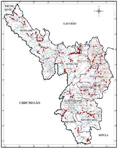
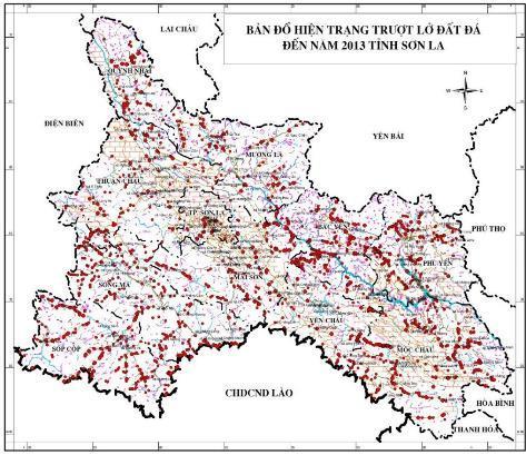
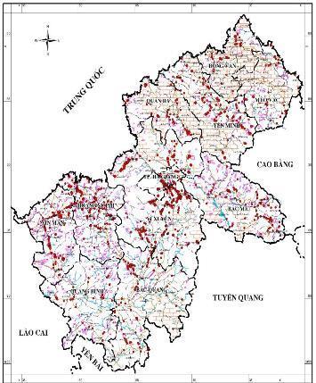
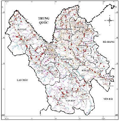
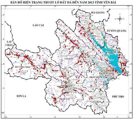
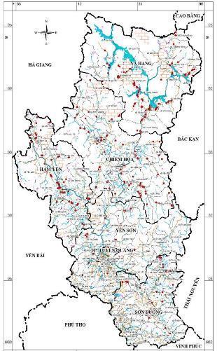
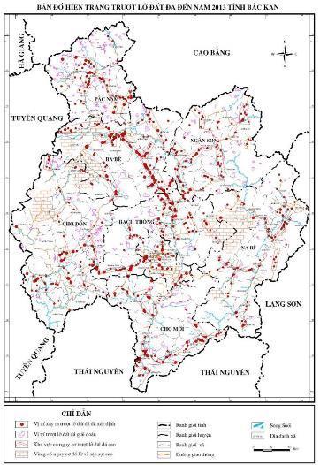
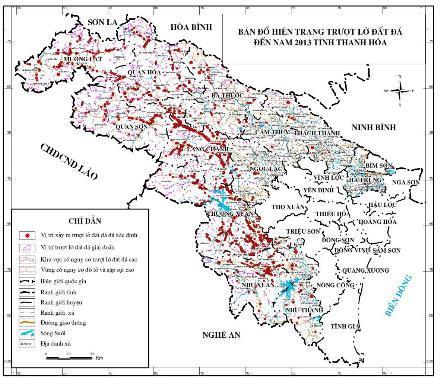
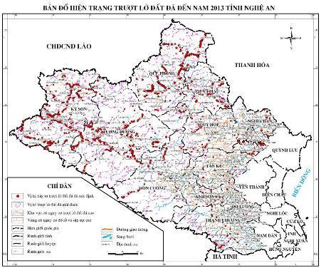
7 PROJECT RESULT SO FAR (10/ /2015) Landslide inventory maps at 1:50,000 scales for 17 Northern mountainous provinces that are compiled for publication

8 PROJECT RESULT SO FAR (10/ /2017) Landslide susceptibility maps at 1:50,000 scales for 10 Northern mountainous provinces: Nghe An, Thanh Hoa, Lao Cai, Yen Bai, Lai Chau, Dien Bien, Son La, Ha Giang, Cao Bang, Bac Kan
9 SFLP: Urgent needs 1. Those maps were not regularly to be updated the environmental factors have kept changing landslides have still occurred previously-produced maps much different from present situation 2. For many high-risk areas, the authorities demand the risk maps at larger scales very difficult to construct due to the lack of necessary input data. 3. It is required to implement a program to update the landslide database for selected high-risk areas.


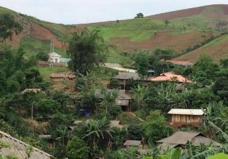
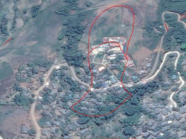
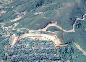
10 Nậm Mười after 21/7/2018 (200mm in 3 days) 3/1/2016


11 Nậm Mười after 21/7/2018 (200mm in 3 days) 3/1/2016
12 II. ONGOING PROJECT Full title: Updating a medium-scale landslide database for high-risk areas using community surveys in Vietnam Study areas: Selected 220 high risk communes in 10 Northern mountainous provinces (20,000 km 2 ) Goals: Investigating and updating the landslide database for the 220 selected highrisk communes in landslide-prone areas in Northern mountainous provinces using community surveys Mapping the landslide risk areas at 1: 10,000 scale and disseminating the result maps to the local authorities and people with community guidance
13 II. ONGOING PROJECT Deliverables An up-to-date spatial landslide database for high-risk communes; A set of landslide inventory, susceptibility and risk maps at 1: scale; Guidelines for dissemination and communication of landslide preparedness, prevention and mitigation for local authorities and people
14 II. ONGOING PROJECT Main approaches Community surveys Geological surveys Image interpretation


15 COMMUNIIY AND GEOLOGICAL SURVEYS Field note... Soil description sheet Field work... Landslide description sheet GIS and Mapping Landslide inventory Database
16 IMAGE INTERPRETATION
17 III. PILOT SURVEYS in high risk communes (835 km 2 ) of 4 landslide-pronce provinces

18 III. PILOT SURVEYS in 2017
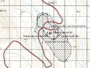
19 III. INITIAL RESULTS: Updated database inventory mapping Xã Previous database Updated Updated unstable database slopes Interviews Nặm Lịch Xuân Lao Huổi Só Sính Phình Lầu Thí Ngài Bản Cái Nậm Mòn Bản Xèo A Mú Sung Phìn Ngan Đản Ván Pờ Ly Ngài Chiến Phố Pà Vầy Sủ Chế Là Phình Hồ La Pán Tẩn An Lương Đại Sơn Viễn Sơn TỔNG
20 III. INITIAL RESULTS: Updated database: susceptibility mapping TT Communes Area (km2) Very high (km2) High Moderate (km2) (km2) Low Very low (km2) Very high (%) High (%) Moderate (%) Low (%) Very low (%) 1 Nặm Lịch Xuân Lao Huổi Só Sính Phình Lầu Thí Ngài Bản Cái Nậm Mòn Bản Xèo A Mú Sung Phìn Ngan Đản Ván Pờ Ly Ngài Chiến Phố Pà Vầy Sủ Chế Là Phình Hồ La Pán Tẩn An Lương Đại Sơn Viễn Sơn TỔNG


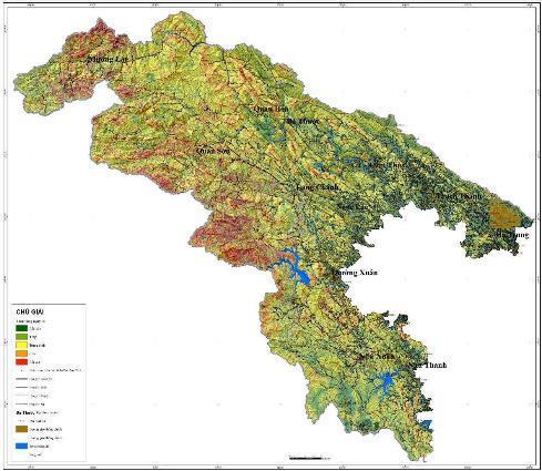
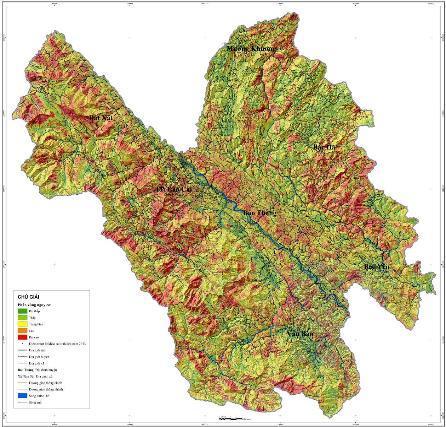
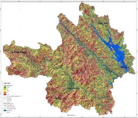
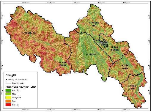
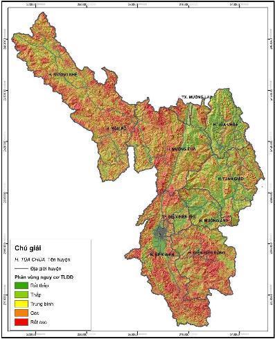
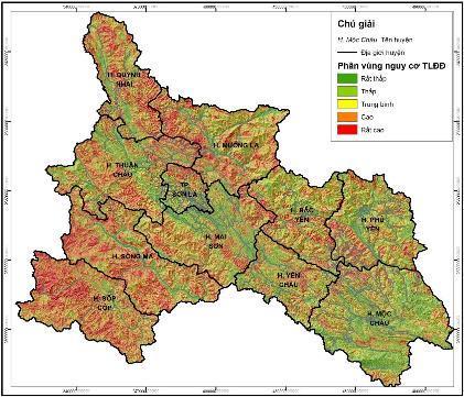
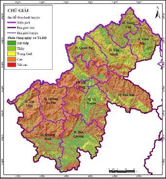
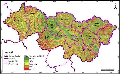
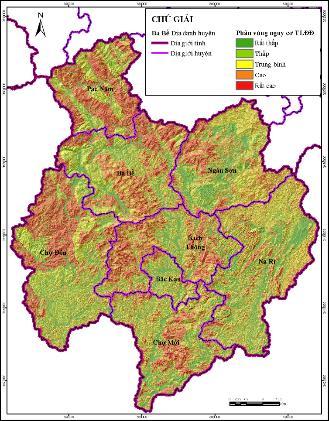
21 III. INITIAL RESULTS Inventory and susceptibility maps at 1: scale

22 III. INITIAL RESULTS Inventory and susceptibility maps at 1: scale


23 III. INITIAL RESULTS Inventory and susceptibility maps at 1: scale

24 III. INITIAL RESULTS Inventory and susceptibility maps at 1: scale

25 III. INITIAL RESULTS Inventory and susceptibility maps at 1: scale


26 III. INITIAL RESULTS Inventory and susceptibility maps at 1: scale


27 III. INITIAL RESULTS Inventory and susceptibility maps at 1: scale

28 III. INITIAL RESULTS Inventory and susceptibility maps at 1: scale

29 III. INITIAL RESULTS Inventory and susceptibility maps at 1: scale


30 III. INITIAL RESULTS Inventory and susceptibility maps at 1: scale


31 III. INITIAL RESULTS Inventory and susceptibility maps at 1: scale

32 III. INITIAL RESULTS Inventory and susceptibility maps at 1: scale


33 III. INITIAL RESULTS Inventory and susceptibility maps at 1: scale

34 III. INITIAL RESULTS Inventory and susceptibility maps at 1: scale

35 III. INITIAL RESULTS Inventory and susceptibility maps at 1: scale

36 III. INITIAL RESULTS Inventory and susceptibility maps at 1: scale

37 III. INITIAL RESULTS Inventory and susceptibility maps at 1: scale

38 III. INITIAL RESULTS Inventory and susceptibility maps at 1: scale

39 III. INITIAL RESULTS Inventory and susceptibility maps at 1: scale

40 III. INITIAL RESULTS Inventory and susceptibility maps at 1: scale
41 IV. CHALLENGES AND NEXT PLANS Updating the landslide database to propose the areas for temporal evacuation and for permament relocation Collaboration with local government for: Community education using Project resutls and deliverables; Updating landslide inventory database from communities through , WebGIS, facebook, SMS, etc.); Setup of a pilot landslide monitoring system. Collaboration with international experts for improve the survey technologies
42 Looking forwards to hearing your comments to improve our work!
Investigation, assessment and warning zonation for landslides in the mountainous regions of Vietnam
 Investigation, assessment and warning zonation for landslides in the mountainous regions of Vietnam (State-Funded Landslide Project SFLP) Dr. Eng. Le Quoc Hung Add: 67 Chien Thang Street, Ha Dong District,
International Symposium on Natural Disaster Mitigation. Local vulnerability assessment of landslides and debris flows
 International Symposium on Natural Disaster Mitigation of landslides and debris flows Lessons learnt from Cam Pha town and Van Don district, Quang Ninh province, Vietnam Nguyen Quoc Phi Faculty of Environment
2014 Summer training course for slope land disaster reduction Taipei, Taiwan, Aug
 MINISTRY OF SCIENCE AND TECHNOLOGY HYDROTECH RESEARCH INSTITUTE MINISTRY OF NATURAL RESOURCES AND ENVIRONMENT VIETNAM INSTITUTE OF GEOSCIENCES AND MINERAL RESOURCES (VIGMR) 2014 Summer training course
ME KONG RIVER COMMISSION FLASH FLOOD GUIDANCE SYSTEM (MRCFFGS)
") NATIONAL HYDRO-METEOROLOGICAL SERVICE IN VIETNAM NATIONAL CENTER FOR HYDRO-METEOROLOGICAL FORECASTING ME KONG RIVER COMMISSION FLASH FLOOD GUIDANCE SYSTEM (MRCFFGS) http://www.nchmf.gov.vn 29 Nov 1 Dec
NATIONAL HYDRO-METEOROLOGICAL SERVICE IN VIETNAM NATIONAL CENTER FOR HYDRO-METEOROLOGICAL FORECASTING ME KONG RIVER COMMISSION FLASH FLOOD GUIDANCE SYSTEM (MRCFFGS) http://www.nchmf.gov.vn 29 Nov 1 Dec
Vietnam Coastal Erosion - Cause and Challenges -
 Administration of Sea and Islands Center for Oceanography University of Transport and Communications, Hanoi Vietnam Vietnam Coastal Erosion - Cause and Challenges - Presenters: Pham Hoang KIEN Le Van CONG
MINISTRY OF NATURAL RESOURCES AND ENVIRONMENT Vietnam Institute of Geosciences and Mineral Resources (VIGMR)
") MINISTRY OF NATURAL RESOURCES AND ENVIRONMENT (VIGMR) Nguyen Quoc Dinh Representative of VIGMR to Sentinel Asia Awaji, Japan, November 1 st,2018 CONTENTS INTRODUCTION TO VIGMR COOPERATION and CONTRIBUTION
MINISTRY OF NATURAL RESOURCES AND ENVIRONMENT (VIGMR) Nguyen Quoc Dinh Representative of VIGMR to Sentinel Asia Awaji, Japan, November 1 st,2018 CONTENTS INTRODUCTION TO VIGMR COOPERATION and CONTRIBUTION
Current Status of Vietnam Coastal Erosion and Major Measures for Mitigation
 Vietnam Administration of Sea and Islands Center for Oceanography University of Transport and Communications Current Status of Vietnam Coastal Erosion and Major Measures for Mitigation Case Study: Thanh
LANDSLIDE MITIGATION IN CCOP
 "International Workshop on Landslide Risk Assessment and Management for ASEAN Member States 1-2 June 2017 Bangkok, Thailand LANDSLIDE MITIGATION IN CCOP Dr. Adichat Surinkum Director Email: adichat_s@ccop.or.th,
Mapping Landslide Events in Vietnam Using the Global Landslide Catalog and GIS
 Mapping Landslide Events in Vietnam Using the Global Landslide Catalog and GIS Minh NGUYEN DINH, Huong NGUYEN, Vietnam Key words: mapping, landslide events, Vietnam, global landslide catalog, GIS SUMMARY
SCIENTIFIC BACKGROUND
 SCIENTIFIC BACKGROUND I. VITAE PROFILE Full name: NGUYEN THI THUC ANH Date of birth: March st, 96 Home town: Hoa Xuan Dong, Dong Hoa district, Phu Yen province Work: Work Address: Home Adress Sex: Female
Implementation Status & Results Vietnam Second Northern Mountains Poverty Reduction Project (P113493)
") Public Disclosure Authorized Public Disclosure Authorized The World Bank Implementation Status & Results Vietnam Second Northern Mountains Poverty Reduction Project (P113493) Operation Name: Second Northern
Public Disclosure Authorized Public Disclosure Authorized The World Bank Implementation Status & Results Vietnam Second Northern Mountains Poverty Reduction Project (P113493) Operation Name: Second Northern
SIMULATION OF A WORST CASE TSUNAMI SCENARIO FROM THE MANILA TRENCH TO VIETNAM
 SIMULATION OF A WORST CASE TSUNAMI SCENARIO FROM THE MANILA TRENCH TO VIETNAM Nguyen Hong Phuong, Vu Ha Phuong, Pham The Truyen Earthquake Information and Tsunami Warning Centre, VAST OUTLINE Earthquake
Using GIS to Assess Natural Hazards in NW Vietnam
 Modern Environmental Science and Engineering (ISSN 2333-2581) July 2017, Volume 3, No. 7, pp. 492-498 Doi: 10.15341/mese(2333-2581)/07.03.2017/009 Academic Star Publishing Company, 2017 www.academicstar.us
Monitoring Urban Space Expansion Using Remote Sensing Data in Ha Long City, Quang Ninh Province in Vietnam
 Monitoring Urban Space Expansion Using Remote Sensing Data in Ha Long City, Quang Ninh Province in Vietnam MY Vo Chi, LAN Pham Thi, SON Tong Si, Viet Key words: VSW index, urban expansion, supervised classification.
Team 09 Nguyen chau lan (Vietnam) Dilum Wannigasekara (Sri lanka)
 Dilum Wannigasekara (Sri lanka)") Team 09 Nguyen chau lan (Vietnam) Dilum Wannigasekara (Sri lanka) contents Part I: Landslide in Vietnam Part II: Case study of Landslide in sri lanka Part I: Introduction of Landslide in hoa binh province
Team 09 Nguyen chau lan (Vietnam) Dilum Wannigasekara (Sri lanka) contents Part I: Landslide in Vietnam Part II: Case study of Landslide in sri lanka Part I: Introduction of Landslide in hoa binh province
Application of a GIS for Earthquake Hazard Assessment and Risk Mitigation in Vietnam
 Application of a GIS for Earthquake Hazard Assessment and Risk Mitigation in Vietnam Nguyen Hong Phuong Earthquake Information and Tsunami Warning Centre, VAST OUTLINE Introduction Fault Source Model and
HEAVY RAIN OVER MID-CENTRAL REGION OF VIETNAM
 HEAVY RAIN OVER MID-CENTRAL REGION OF VIETNAM ----------------------------------------------------------------------- S.Eng. Dang Thi Mai; Dr. Nguyen Thi Tan Thanh National Hydro Meteorological Service
- facilitate the preparation of landslide inventory and landslide hazard zonation maps for the city, - development of precipitation thresholds,
 Date of Submission 29.03.2012 IPL Project Proposal Form 2012 (MAXIMUM: 3 PAGES IN LENGTH) 1. Project Title: (2 lines maximum)-introducing Community-based Early Warning System for Landslide Hazard Management
Date of Submission 1 March IPL Project Annual Report Form 2014
 Date of Submission 1 March 2015 IPL Project Annual Report Form 2014 1. Project Title : Development of landslide risk assessment technology along transportation arteries in Vietnam. 2. Main Project Fields
CLIMATE CHANGE IN VIET NAM: Observed and Future Projection
 2017 ACTS Workshop on Extreme Weather Forecast and Water Resources Management CLIMATE CHANGE IN VIET NAM: Observed and Future Projection Mai Van KHIEM Viet Nam Institute of Meteorology, Hydrology and Climate
KHI X L T SÔNG H NG VÀO SÔNG ÁY
 XÂY D NG B N NG P L T KHU V C H DU TÓM T T T KHI X L T SÔNG H NG VÀO SÔNG ÁY Lê Vi t S n 1 Bài báo này trình bày k t qu nghiên c u, ánh giá r i ro ng p l vùng h du sông áy khi x l t sông H ng vào sông
Hydraulic modelling for flood vulnerability assessment, case study in river basins in North Central Vietnam
 Hydraulic modelling for flood vulnerability assessment, case study in river basins in North Central Vietnam Tran Ngoc Anh 1*,2, Dang Dinh Kha 1,2, Dang Dinh Duc 2, Nguyen Thanh Son 1 1 Faculty of Hydrology
RISK OF TYPHOON AND STORM SURGES IN COASTAL AREAS OF VIETNAM
 RISK OF TYPHOON AND STORM SURGES IN COASTAL AREAS OF VIETNAM Hoang Duc Cuong, Nguyen Ba Thuy, Nguyen Van Huong, Du Duc Tien Vietnam National Center for Hydro-meteorological Forecasting (NCHMF) Hanoi, 26-27
IPL Project (IPL - 175) Annual Report Form 2017
 Annual Report Form 2017") Date of Submission 03 March 2018 IPL Project (IPL - 175) Annual Report Form 2017 1 January 2017 to 31 December 2017 1. Project Number (approved year) and Title: IPL-175 (2012) Development of landslide
Date of Submission 03 March 2018 IPL Project (IPL - 175) Annual Report Form 2017 1 January 2017 to 31 December 2017 1. Project Number (approved year) and Title: IPL-175 (2012) Development of landslide
Author(s) Chu, Van Ngoi; Luong, Thi Thu Hoai. Citation Vietnamese Academy of Science and T P.184-P.191.
 Chu, Van Ngoi; Luong, Thi Thu Hoai. Citation Vietnamese Academy of Science and T P.184-P.191.") Title RESEARCH AND ASSESSMENT OF LANDSLID HIGHWAY NO.12 IN THE NORTHWEST VIET Author(s) Chu, Van Ngoi; Luong, Thi Thu Hoai Annual Report of FY 2007, The Core Citation between Japan Society for the Promo
Title RESEARCH AND ASSESSMENT OF LANDSLID HIGHWAY NO.12 IN THE NORTHWEST VIET Author(s) Chu, Van Ngoi; Luong, Thi Thu Hoai Annual Report of FY 2007, The Core Citation between Japan Society for the Promo
Training Needs Assessment for Provincial and District Staff on Forecast Products and Early Warning Information
 Strengthening Capacities to Enhance Coordinated and Integrated Disaster Risk Reduction Actions and Adaptation to Climate Change in Agriculture in the Northern Mountain Regions of Viet Nam Training Needs
Optical Remote Sensing Method for Detecting Urban Green Space as Indicator Serving City Sustainable Development
 Proceedings Optical Remote Sensing Method for Detecting Urban Green Space as Indicator Serving City Sustainable Development Tran Thi Van *, Nguyen Dang Huyen Tran, Ha Duong Xuan Bao, Dinh Thi Thanh Phuong,
12/05/2016. The First step in Adaptation to future climate change Reduce Vulnerability and Exposure to present Climate Variability (IPCC 2014)
") Integrating CCA, DRR and L+D to Address Emerging Challenges due to Slow Onset Processes Joy Jacqueline Pereira (Project Leader), SEADPRI-Universiti Kebangsaan Malaysia, Nguyen Van Thang (Collaborator),
Integrating CCA, DRR and L+D to Address Emerging Challenges due to Slow Onset Processes Joy Jacqueline Pereira (Project Leader), SEADPRI-Universiti Kebangsaan Malaysia, Nguyen Van Thang (Collaborator),
Populations effected by flood top ten districts
 2050 - Populations effected by flood top ten districts 14 Extreme A2 Extreme A2 with dyke District Area (Ha) Population 2050 People affected Percent area affected People affected Percent area affected
AND THE COOPERATION WITH SENTINEL ASIA FOR DISASTER MANAGEMENT
 Ministry of Natural resources and Environment National Remote Sensing DEpartment NATIONAL REMOTE SENSING DEPARTMENT (NRSD) AND THE COOPERATION WITH SENTINEL ASIA FOR DISASTER MANAGEMENT By: Dr. Chu Hai
Public Disclosure Copy. Implementation Status & Results Report Vietnam: Project for Improved Land Governance and Databases (VILG) (P154387)
 (P154387)") Public Disclosure Authorized EAST ASIA AND PACIFIC Vietnam Social, Urban, Rural and Resilience Global Practice Global Practice IBRD/IDA Investment Project Financing FY 2017 Seq No: 4 ARCHIVED on 07-Dec-2017
Public Disclosure Authorized EAST ASIA AND PACIFIC Vietnam Social, Urban, Rural and Resilience Global Practice Global Practice IBRD/IDA Investment Project Financing FY 2017 Seq No: 4 ARCHIVED on 07-Dec-2017
Nguyen Ngoc Thach 1, *, Pham Xuan Canh 2 VNU University of Science, 334 Nguyen Trai, Hanoi, Vietnam
 VNU Journal of Science, Earth Sciences 8 (01) 44-6 Risk assessment of flash muddy flood and inundation of western Tam Dao mountainous region, Vinh Phuc province, Vietnam by using intergrated concept of
VNREDSat-1. Vietnam Natural Resources, Environment and Disaster monitoring Satellite. Lai Anh Khoi SPACE TECHNOLOGY INSTITUTE
 VNREDSat-1 Vietnam Natural Resources, Environment and Disaster monitoring Satellite Lai Anh Khoi SPACE TECHNOLOGY INSTITUTE JPTM2014 Yangon, Nov. 19-21, 2014 General information (1) Project Owner: Vietnam
MINISTRY OF NATURAL RESOURCES AND ENVIRONMENT
 MINISTRY OF NATURAL RESOURCES AND ENVIRONMENT HÀ NỘI, 2016 CLIMATE CHANGE AND SEA LEVEL RISE SCENARIOS FOR VIET NAM SPM Summary for policymakers Main authors: Tran Thuc, Nguyen Van Thang, Huynh Thi Lan
Utilization of satellite precipitation data for flood management
 Utilization of satellite precipitation data for flood management Tetsuya IKEDA Infrastructure Development Institute (IDI) Japan Typhoon Committee Integrated Workshop November 7, 2011 Nha Trang, Vietnam,
RESPONSE TO TYPHOON HAIYAN IN VIET NAM
 RESPONSE TO TYPHOON HAIYAN IN VIET NAM Dr. Nguyen Dai Khanh Mr. Vo Van Hoa ESCAP/WMO typhoon Committee 8 th IWS/2 nd TRCG Forum Ma Cau, 02-06 December 2013 Introduction TY Haiyan-1330 In the morning 04/11,
SUPPLEMENTAL MATERIAL. Modulation of Daily Rainfall in Southern Vietnam by the Madden-Julian. Oscillation and Convectively Coupled Equatorial Waves
 SUPPLEMENTAL MATERIAL Modulation of Daily Rainfall in Southern Vietnam by the Madden-Julian Oscillation and Convectively Coupled Equatorial Waves Roderick van der Linden 1 Institute for Geophysics and
PROPOSED CCOP WORKPLAN 2019
 CCOP-54AS/6- CCOP-71SC/3-4 as of 10 October 2018 COORDINATING COMMITTEE FOR GEOSCIENCE PROGRAMMES IN EAST AND SOUTHEAST ASIA (CCOP) 54 th CCOP Annual Session 71 st CCOP Steering Committee Meeting 28 October
MEMBER REPORT. ESCAP/WMO Typhoon Committee 10 th IWS SOCIALIST REPUBLIC OF VIET NAM
 MEMBER REPORT ESCAP/WMO Typhoon Committee 10 th IWS SOCIALIST REPUBLIC OF VIET NAM October 2015 CONTENTS I. Overview of tropical cyclones which have affected/impacted Member s area since the last Typhoon
Progress Report. Flood Hazard Mapping in Thailand
 Progress Report Flood Hazard Mapping in Thailand Prepared By: Mr. PAITOON NAKTAE Chief of Safety Standard sub-beuro Disaster Prevention beuro Department of Disaster Prevention and Mitigation THAILAND E-mail:
ANALYSIS OF CHANGES IN THE RIVERBANKS OF MEKONG RIVER - VIETNAM BY USING MULTI-TEMPORAL REMOTE SENSING DATA
 ANALYSIS OF CHANGES IN THE RIVERBANKS OF MEKONG RIVER - VIETNAM BY USING MULTI-TEMPORAL REMOTE SENSING DATA Lam Dao Nguyen a, Nguyen Thanh Minh a, Pham Thi Mai Thy b, Hoang Phi Phung a and Hoang Van Huan
GIÁO H I PH T GIÁO VI T NAM TH NG NH T
 BUREAU INTERNATIONAL D'INFORMATION BOUDDHISTE INTERNATIONAL BUDDHIST INFORMATION BUREAU PHÒNG THÔNG TIN PH T GIÁO QU C T C quan Thông tin và Phát ngôn c a Vi n Hóa Ð o, Giáo h i Ph t giáo Vi t Nam Th ng
The Third UN-GGIM-AP Plenary Meeting. Use of Geospatial Information in Disaster and Coordination among NDMA and Relevant Organizations/Stakeholders
 The Third UN-GGIM-AP Plenary Meeting Use of Geospatial Information in Disaster and Coordination among NDMA and Relevant Organizations/Stakeholders Bali Indonesia 10 November 2014 Bernardus Wisnu Widjaja
HA NOI NATIONAL UNIVERSITY PUBLISHING HOUSE
 Stratigraphic Units of Viet Nam Authors Tong-Dzuy Thanh, Vu Khuc, Dang Tran Huyen, Do Bat, Doan Nhat Truong, Nguyen Dich Dy, Nguyen Huu Hung, Pham Huy Thong, Pham Kim Ngan, Ta Hoa Phuong, Tran Huu Dan,
Proposal for Research and Investment Activities in the Coast and Estuaries (A Case Study in the North Central Coast of Viet Nam)
") 2017/SOM3/EPWG/019 Agenda Item: 7.2.3 Proposal for Research and Investment Activities in the Coast and Estuaries (A Case Study in the North Central Coast of Viet Nam) Purpose: Information Submitted by:
2017/SOM3/EPWG/019 Agenda Item: 7.2.3 Proposal for Research and Investment Activities in the Coast and Estuaries (A Case Study in the North Central Coast of Viet Nam) Purpose: Information Submitted by:
The Safeland Project General Overview and Monitoring Technology Development
 Ber. Geol. B. A., 82, ISSN 1017 8880 Landslide Monitoring Technologies & Early Warning Systems The Safeland Project General Overview and Monitoring Technology Development The SafeLand Consortium a), N.
Assessment of climate change impacts on salinity intrusion in Hong-Thai Binh and Dong Nai river basins
 VNU Journal of Science, Earth Sciences 27 (2011) 54-61 Assessment of climate change impacts on salinity intrusion in Hong-Thai Binh and Dong Nai river basins Tran Hong Thai, Tran Thi Van* Vietnam Institute
SOCIALIST REPUBLIC OF VIET NAM COUNTRY REPORT
 SOCIALIST REPUBLIC OF VIET NAM COUNTRY REPORT ESCAP / WMO 40 TH SESSION OF THE TYPHOON COMMITTEE Macao, China, 21-26 November 2007 NATIONAL HYDRO-METEOROLOGICAL SERVICE CONTENTS I. Overview of Meteorological
Xuân Hòa, ngày 29 tháng 9, 2018
 VIỆN TOÁN HỌC & ĐẠI HỌC SƯ PHẠM HÀ NỘI 2 HỘI THẢO MỘT NGÀY HỆ ĐỘNG LỰC VÀ PHƯƠNG TRÌNH ĐẠO HÀM RIÊNG Xuân Hòa, ngày 29 tháng 9, 2018 CHƯƠNG TRÌNH & TÓM TẮT BÁO CÁO XUÂN HÒA, 2018 Ban tổ chức Trần Văn
A Data Fusion Approach to Real-time Monitoring Systems and Information Management
 Landslide Preparedness in the ASEAN Member States A Data Fusion Approach to Real-time Monitoring Systems and Information Management Jessada Karnjana, PhD National Electronics and Computer Technology Center
Overview of Early Warning Systems and the role of National Meteorological and Hydrological Services
 Overview of Early Warning Systems and the role of National Meteorological and Hydrological Services South Africa Second Experts Symposium on Multi-Hazard Early Warning Systems With focus on the Role of
EVALUATION OF THE VULNERABILITY OF TitleCOASTAL SOCIO-NATURAL SYSTEMS (EXAM FROM KHANH HOA COASTAL ZONE) Author(s) Nguyen, Thi Thuy Hang; Pham, Hung T
 Author(s) Nguyen, Thi Thuy Hang; Pham, Hung T") EVALUATION OF THE VULNERABILITY OF TitleCOASTAL SOCIO-NATURAL SYSTEMS (EXAM FROM KHANH HOA COASTAL ZONE) Author(s) Mai, Trong Nhuan; Tran, Thanh Hai; Nguyen, Thi Thuy Hang; Pham, Hung T Annual Report of
EVALUATION OF THE VULNERABILITY OF TitleCOASTAL SOCIO-NATURAL SYSTEMS (EXAM FROM KHANH HOA COASTAL ZONE) Author(s) Mai, Trong Nhuan; Tran, Thanh Hai; Nguyen, Thi Thuy Hang; Pham, Hung T Annual Report of
Landslide hazard assessment in the Khelvachauri area, Georgia
 Report on the project of AES Geohazards Stream Landslide hazard assessment in the Khelvachauri area, Georgia May 2010 George Jianping Panisara Gaprindashvili Guo Daorueang Institute of Geo-Information
USE OF GEOREFERENCE INFORMATION FOR DRM Arnob Bormdoi Research Associate, GIC
 USE OF GEOREFERENCE INFORMATION FOR DRM Arnob Bormdoi Research Associate, GIC CONTENTS INTRODUCTION THE IMPORTANCE OF SPATIAL INFORMATION CASE STUDIES SUMMARY INTRODUCTION The process of defining how raster
STATUS OF HAZARD MAPS VULNERABILITY ASSESSMENTS AND DIGITAL MAPS
 JapanInternational Cooperation Agency STATUS OF HAZARD MAPS VULNERABILITY ASSESSMENTS AND DIGITAL MAPS ANGUILLA REPORT THE CARIBBEAN DISASTER EMERGENCY RESPONSE AGENCY () Table of Contents Page Preface
Procurement Plan. 3. Reference to (if any) Project Operational/Procurement Manual: January 28, 2016.
 Project Operational/Procurement Manual: January 28, 2016.") Public Disclosure Authorized Public Disclosure Authorized Public Disclosure Authorized Public Disclosure Authorized I. General Plan 1. Bank s approval Date of the procurement Plan September 28, 2015 2.
Public Disclosure Authorized Public Disclosure Authorized Public Disclosure Authorized Public Disclosure Authorized I. General Plan 1. Bank s approval Date of the procurement Plan September 28, 2015 2.
Interpretive Map Series 24
 Oregon Department of Geology and Mineral Industries Interpretive Map Series 24 Geologic Hazards, and Hazard Maps, and Future Damage Estimates for Six Counties in the Mid/Southern Willamette Valley Including
HỘI NGHỊ QUANG HỌC QUANG PHỔ TOÀN QUỐC LẦN THỨ 10 ( HNQHQP-10) Hall C. November 12, 2018 (Monday)
 Hall C. November 12, 2018 (Monday)") HỘI NGHỊ QUANG HỌC QUANG PHỔ TOÀN QUỐC LẦN THỨ 10 ( HNQHQP-10) Hall C November 12, 2018 (Monday) Prof. Nguyen Manh An (Hong Duc Uni., Thanh Hoa) Dr. Pham Hong Minh (IOP, VAST, Ha Noi) (C-01) 13:30 13:55
HỘI NGHỊ QUANG HỌC QUANG PHỔ TOÀN QUỐC LẦN THỨ 10 ( HNQHQP-10) Hall C November 12, 2018 (Monday) Prof. Nguyen Manh An (Hong Duc Uni., Thanh Hoa) Dr. Pham Hong Minh (IOP, VAST, Ha Noi) (C-01) 13:30 13:55
Model development for WebAtlas system applying in administration management.
 Model development for WebAtlas system applying in administration management. Bui Ngoc Quy, Vo Ngọc Dung, Nguyen Danh Duc, University of mining and geology, Viet Nam Key words: Webatlas, Web Map, Electronic
Landslide Hazard Assessment Methodologies in Romania
 A Scientific Network for Earthquake, Landslide and Flood Hazard Prevention SciNet NatHazPrev Landslide Hazard Assessment Methodologies in Romania In the literature the terms of susceptibility and landslide
Proceeding Optical Remote Sensing Method for Detecting Urban Green Space as Indicator Serving City Sustainable Development
 Proceeding Optical Remote Sensing Method for Detecting Urban Green Space as Indicator Serving City Sustainable Development Tran Thi Van *, Nguyen Dang Huyen Tran, Ha Duong Xuan Bao, Dinh Thi Thanh Phuong,
THE NEW DNR LANDSLIDE HAZARDS PROGRAM
 THE NEW DNR LANDSLIDE HAZARDS PROGRAM Kara Jacobacci, G.I.T. Landslide Hazards Program Washington Geological Survey Washington Department of Natural Resources LEGISLATIVE FUNDING 2015 session DNR requested
CHARACTERISTICS OF GEOTHERMAL FLUIDS IN NORTH-WEST AREA OF NORTH PLAIN, VIETNAM
 Proceedings of the 8th Asian Geothermal Symposium, December 9-10, 2008 CHARACTERISTICS OF GEOTHERMAL FLUIDS IN NORTH-WEST AREA OF NORTH PLAIN, VIETNAM Cao Duy Giang and Tran Trong Thang Vietnam Science
Tsunami hazard risk and early warning projects at Global Geophysics Institute, Vietnam
 Tsunami hazard risk and early warning projects at Global Geophysics Institute, Vietnam presented by Dr Kelvin Berryman, GNS Science, New Zealand k.berryman@gns.cri.nz on behalf of Prof. Bui C. Que,, Director
Impacts of climate change on the flow in Hong-Thai Binh and Dong Nai river basins
 VNU Journal of Science, Earth Sciences 27 (2011) 98-106 Impacts of climate change on the flow in Hong-Thai Binh and Dong Nai river basins Tran Hong Thai*, Tran Thuc Vietnam Institute of Meteorology, Hydrology
Spatial dependence in the growth process and implications for convergence rate: evidence on Vietnamese provinces
 JOURNAL OF THE ASIA PACIFIC ECONOMY, 2017 https://doi.org/10.1080/13547860.2017.1351764 Spatial dependence in the growth process and implications for convergence rate: evidence on Vietnamese provinces
SESSION C: OPTICS, LASER AND APPLICATIONS November 27, 2012 (Thuesday)
") SESSION C: OPTICS, LASER AND APPLICATIONS November 27, 2012 (Thuesday) Chairperson: Prof. Dr. Tran Ba Chu (Academy of Military Sci. & Tech, Hanoi) Dr. Nguyen Huy Bang (Vinh University) (C-01) 13:30 13:55
SESSION C: OPTICS, LASER AND APPLICATIONS November 27, 2012 (Thuesday) Chairperson: Prof. Dr. Tran Ba Chu (Academy of Military Sci. & Tech, Hanoi) Dr. Nguyen Huy Bang (Vinh University) (C-01) 13:30 13:55
Model development for web - atlas system applying in administration management
 VNU Journal of Science, Earth Sciences 28 (2012) 29-36 Model development for web - atlas system applying in administration management Bui Ngoc Quy* Ha Noi University of Mining and Geology, Dong Ngac, Tu
Proceedings of the El Niño Early Warning Workshop and Forum in Vietnam
 Technical assistance to Vietnam for strengthening national capacities to deal with weather related natural disasters, promote advanced methodologies for weather forecasting, dissemination of warnings to
PUBLIC WEATHER SERVICES
 WMO AGENDA ITEM 2.1(1) PUBLIC WEATHER SERVICES Gerald Fleming Chair, OPAG/PWS (Paraguay 8-12 September 2014) WMO - Public Weather Services, WDS WMO Summary CBS requested to make decisions on: Adopt Draft
CCOP-DANIDA. Institutional Capacity Building Project ICB-CCOP 1. Yinggehai-Song Hong Basin Case Study Fieldtrip Study in Northeast
 CCOP-DANIDA Institutional Capacity Building Project ICB-CCOP 1 Yinggehai-Song Hong Basin Case Study Fieldtrip Study in Northeast Vietnam, May 15-17, 2006 Date and Venue: The fieldtrip was held from 15
Establishing the Method for Assessing Flood Vulnerability in Ho Chi Minh City, Vietnam A Case Study in District 6
 Journal of Environmental Science and Engineering B 7 (2018) 72-82 doi:10.17265/2162-5263/2018.02.005 D DAVID PUBLISHING Establishing the Method for Assessing Flood Vulnerability in Ho Chi Minh City, Vietnam
Prevention and remediation of rockslide at left portal of north tunnel of Da Nang Qu ang Ngai expressway in Quang Nam, Vietnam
 IOP Conference Series: Earth and Environmental Science PAPER OPEN ACCESS Prevention and remediation of rockslide at left portal of north tunnel of Da Nang Qu ang Ngai expressway in Quang Nam, Vietnam To
SÁNG TH T, NGÀY
 4 SÁNG TH T, NGÀY 23.4.2008 07h00 08h30 Xe a i bi u t Vi n Toán h c lên Ba Vì 8h30 09h00 ón ti p i bi u t i Ba Vì 09h00 09h15 Khai m c H i th o 09h15 10h15 Ch t a: Hoàng Xuân Phú Hoàng T y (Bài gi ng m
GIS AND REMOTE SENSING FOR GEOHAZARD ASSESSMENT AND ENVIRONMENTAL IMPACT EVALUATION OF MINING ACTIVITIES AT QUY HOP, NGHE AN, VIETNAM
 GIS AND REMOTE SENSING FOR GEOHAZARD ASSESSMENT AND ENVIRONMENTAL IMPACT EVALUATION OF MINING ACTIVITIES AT QUY HOP, NGHE AN, VIETNAM QuocPhi Nguyen 1, Phuong Nguyen 1, ThiHoa Nguyen 2 and TienPhu Nguyen
D DAVID PUBLISHING. 1. Introduction. 2. Methodology. Truong Thanh Phi
 Journal of Geological Resource and Engineering 2 (2016) 81-88 doi:10.17265/2328-2193/2016.02.004 D DAVID PUBLISHING Some Results of Quantitative Analysis of Fracture Orientation Distribution along the
Hawke s Bay Liquefaction Hazard Report - Frequently Asked Questions
 Hawke s Bay Liquefaction Hazard Report - Frequently Asked Questions What is liquefaction? Liquefaction occurs when an earthquake shakes up water-logged sediments. As a result, the soil behaves like a liquid
Evaluating Flood Hazard Potential in Danang City, Vietnam Using FOSS4G
 Free and Open Source Software for Geospatial (FOSS4G) Conference Proceedings Volume 15 Seoul, South Korea Article 28 2015 Evaluating Flood Hazard Potential in Danang City, Vietnam Using FOSS4G An Tran
GEO Geohazards Community of Practice
 GEO Geohazards Community of Practice 1) Co-Chair of GHCP With input from: Stuart Marsh, GHCP Co-Chair Francesco Gaetani, GEO Secretariat and many GHCP contributors 1) Nevada Bureau of Mines and Geology
Determination of Marine Gravity Anomalies in the Truong Sa Archipelago s Sea Territory Using Satellite Altimeter Data
 This is a Peer Reviewed Paper Determination of Marine Gravity Anomalies in the Truong Sa Archipelago s Sea Territory Using Satellite Altimeter Data NGUYEN Van Sang, VU Van Tri, PHAM Van Tuyen, Vietnam
Ngày g i bài: Ngày ch p nh n:
 Vietnam J. Agri. Sci. 2017, Vol. 15, No. 7: 962-968 T p chí Khoa h c Nông nghi p Vi t Nam 2017, 15(7): 962-968 www.vnua.edu.vn 1 1 1, Hoàng Kim Giao 2* 1 Vi n nghiên c a TH 2 Hi p h n Email * : hoangkimgiao53@gmail.com
Wainui Beach Management Strategy (WBMS) Summary of Existing Documents. GNS Tsunami Reports
 Summary of Existing Documents. GNS Tsunami Reports") Wainui Beach Management Strategy (WBMS) Summary of Existing Documents GNS Tsunami Reports a) Review of Tsunami Hazard and Risk in New Zealand ( National Risk Report ) b) Review of New Zealand s Preparedness
Wainui Beach Management Strategy (WBMS) Summary of Existing Documents GNS Tsunami Reports a) Review of Tsunami Hazard and Risk in New Zealand ( National Risk Report ) b) Review of New Zealand s Preparedness
Using Reanalysis SST Data for Establishing Extreme Drought and Rainfall Predicting Schemes in the Southern Central Vietnam
 Using Reanalysis SST Data for Establishing Extreme Drought and Rainfall Predicting Schemes in the Southern Central Vietnam Dr. Nguyen Duc Hau 1, Dr. Nguyen Thi Minh Phuong 2 National Center For Hydrometeorological
Report of the Working Group 2 Data Sharing and Integration for Disaster Management *
 UNITED NATIONS E/CONF.104/6 ECONOMIC AND SOCIAL COUNCIL Twentieth United Nations Regional Cartographic Conference for Asia and the Pacific Jeju, 6-9 October 2015 Item 5 of the provisional agenda Report
RETA 6422: Mainstreaming Environment for Poverty Reduction Category 2 Subproject
 RETA 6422: Mainstreaming Environment for Poverty Reduction Category 2 Subproject A. Basic Data 1. Subproject Title: Poverty-Environment Mapping to Support Decision Making 2. Country Director: Adrian Ruthenberg
Table G - 6. Mitigation Actions Identified for Implementation by the City of Kent ( ) (From Wilkin County Master Mitigation Action Chart)
 (From Wilkin County Master Mitigation Action Chart)") Table G - 6. Actions Identified by the () (From Master Action Chart) Multi-Hazard Plan, 2017 Action Comments 5 All-Hazards Local Planning & Regulations Update the Operations Plan on an annual basis. Work
Table G - 6. Actions Identified by the () (From Master Action Chart) Multi-Hazard Plan, 2017 Action Comments 5 All-Hazards Local Planning & Regulations Update the Operations Plan on an annual basis. Work
held on 4 June 2013 Prof. Yoshimori Honkura, Program Officer of Japan Science and Technology Agency (JST) Jakarta, Indonesia Pan Pacific Hotel)
 Jakarta, Indonesia Pan Pacific Hotel)") Overview of the Outcomes from e-asia JRP Disaster Prevention Workshop held on 4 June 2013 Prof. Yoshimori Honkura, Program Officer of Japan Science and Technology Agency (JST) Jakarta, Indonesia (@Sari
Overview of the Outcomes from e-asia JRP Disaster Prevention Workshop held on 4 June 2013 Prof. Yoshimori Honkura, Program Officer of Japan Science and Technology Agency (JST) Jakarta, Indonesia (@Sari
Roles of NGII in successful disaster management
 The Second UN-GGIM-AP Plenary Meeting Roles of NGII in successful disaster management Republic of Korea Teheran Iran 28 October 2013 Sanghoon Lee, Ph.D. NGII Outline Type of Disasters Occur in Korea Practical
Use of Geospatial data for disaster managements
 Use of Geospatial data for disaster managements Source: http://alertsystemsgroup.com Instructor : Professor Dr. Yuji Murayama Teaching Assistant : Manjula Ranagalage What is GIS? A powerful set of tools
THE INFLUENCE OF SEA SURFACE TEMPERATURE ON INTENSITY AND TRACK OF TROPICAL CYCLONE OVER VIETNAM EAST SEA
 MINISTRY OF NATURAL RESOURCES AND ENVIRONMENT VIETNAM INSTITUTE OF METEOROLOGY HYDROLOGY AND CLIMATE CHANGE ------------------------------- THE INFLUENCE OF SEA SURFACE TEMPERATURE ON INTENSITY AND TRACK
Objectives and hypotheses. Remote sensing: applications for landslide hazard assessment and risk management. Ping Lu (University of Firenze) Methods
 Methods") Topical Workshop Remote sensing: applications for landslide hazard assessment and risk management Ping Lu (University of Firenze) Supervisors: Prof. Nicola Casagli; Prof. Filippo Catani (Unifi) Dr. Veronica
Topical Workshop Remote sensing: applications for landslide hazard assessment and risk management Ping Lu (University of Firenze) Supervisors: Prof. Nicola Casagli; Prof. Filippo Catani (Unifi) Dr. Veronica
OVERVIEW OF GEOTHERMAL RESOURCE EVALUATION OF BANG LE THUY- QUANG BINH
 Proceedings of the 8th Asian Geothermal Symposium, December 9-10, 2008 OVERVIEW OF GEOTHERMAL RESOURCE EVALUATION OF BANG LE THUY- QUANG BINH Nguyen Tien Hung 1. Shigetaka Nakanishi 2, Shigeo Tezuka 3
Member Country Report of Vietnam
 CCOP-47AS/3-14 COORDINATING COMMITTEE FOR GEOSCIENCE PROGRAMMES IN EAST AND SOUTHEAST ASIA (CCOP) 47 th CCOP Annual Session 17-21 October 2010 Manado, Indonesia Member Country Report of Vietnam Submitted
ORDER THEORY OF ALLOY β CuZn
 Proc. Natl. Conf. Theor. Phys. 36 (2011), pp. 195-200 ORDER THEORY OF ALLOY β CuZn PHAM DINH TAM Le Quy Don University of Technology, 100 Hoang Quoc Viet, Cau Giay, Hanoi PHAM DUY TAN College of Armor,
Nguyen Hoang Khanh Linh, Le Ngoc Phuong Quy, Truong Do Minh Phuong and Nguyen Trac Ba An
 Journal of Agricultural Science and Technology A and B & Hue University Journal of Science 7 (2017) 48-59 doi: 10.17265/2161-6256/2017.10.007S D DAVID PUBLISHING Application of Remote Sensing and GIS Technology
Huong River. Serial No. : Viet Nam-8 Location: Thua Thien Hue Province, Viet Nam N 16 00' '
 Viet Nam 8 Huong River Map of River Table of Basic Data Name: Huong River Serial No. : Viet Nam-8 Location: Thua Thien Hue Province, Viet Nam N 16 00' - 14 40' E 107 07' - 107 50' 2 Area: 2,830 km Length
LÝ LỊCH KHOA HỌC. CỘNG HOÀ XÃ HỘI CHỦ NGHĨA VIỆT NAM Độc lập - Tự do - Hạnh phúc BỘ Y TẾ TRƯỜNG ĐẠI HỌC DƯỢC HÀ NỘI. 1. Họ và tên: Vũ Đặng Hoàng
 BỘ Y TẾ TRƯỜNG ĐẠI HỌC DƯỢC HÀ NỘI CỘNG HOÀ XÃ HỘI CHỦ NGHĨA VIỆT NAM Độc lập - Tự do - Hạnh phúc 1. Họ và tên: Vũ Đặng Hoàng LÝ LỊCH KHOA HỌC 2. Ngày tháng năm sinh: 07/01/1976 Nam Dân tộc: Kinh 3. Quê
Analysis stability of rock slope at left bank of South portal of North tunnel Da Nang Quang Ngai expressway
 an ISRM specialized conference Analysis stability of rock slope at left bank of South portal of North tunnel Da Nang Quang Ngai expressway Pham Quoc Tuan a,b *, Phi Hong Thinh c, Nghiem Huu Hanh a a Vietnam
Improvement of Hazard Assessment and Management in the Philippines
 Improvement of Hazard Assessment and Management in the Philippines (2014 Summer Training Course for Slope Land Disaster Reduction) Ian Alejandrino (Philippines) Nguyen Manh Hieu (Vietnam) Presentation
Disaster Risk Reduction in Survey for Seismic Protection of MES
 Survey for Seismic Protection Ministry of Emergency Situations of Republic of Armenia Disaster Risk Reduction in Survey for Seismic Protection of MES Syuzanna Kakoyan Leading specialist at the Department