Improvement and Ensemble Strategy of Heavy-Rainfall Quantitative Precipitation Forecasts using a Cloud-Resolving Model in Taiwan
|
|
|
- Marilynn Patterson
- 5 years ago
- Views:
Transcription
1 Improvement and Ensemble Strategy of Heavy-Rainfall Quantitative Precipitation Forecasts using a Cloud-Resolving Model in Taiwan Chung-Chieh Wang Department of Earth Sciences, National Taiwan Normal University, Taipei, Taiwan Acknowledgements: SH Chen, BY Chuang, CS Chang, SY Huang, CC Huang, YW Wang, TTFRI, NCHC Workshop on Disaster Risk Reduction in Extreme Climate 23 November 2017, Taipei, Taiwan
2 Presentation outline 1. Why Cloud-Resolving Models for QPFs? 1.1 Real-Time Cloud-Resolving Forecasts by CReSS in Taiwan 1.2 Verification of 24-h QPFs: Standard Categorical Matrices 1.3 Current Skill Level for Typhoon QPFs 2. How CReSS Performs at Short Range (0-72 h)? 2.1 For 24-h typhoon QPFs: (Six) Seasons 2.2 For 24-h Mei-yu QPFs: (3 Seasons) 3. How to Get Ensemble and Improve Further? 3.1 A Strategy to Obtain Cloud-Resolving QPFs at Longer Range 3.2 Usefulness of Daily Time-Lagged Ensemble in Six-hourly Time-Lagged Ensemble for Three Typhoons 4. Conclusion and Summary 2

3 1. Why Cloud-Resolving Models for QPFs? 1.1 Real-Time Cloud-Resolving Forecasts by CReSS in Taiwan Real-time CReSS forecasts since , non-stop year-round since 2010 Gradual increases in resolution, forecast length, and domain size Using NCEP GFS 1 x 1 analyses/forecasts as IC/BCs (0.5 x 0.5 since 2013) Current forecasts (40L) every 6 h out to 78 h: 5 km (216 x 180) 2.5 km (600 x 480) NTNU/Department of Earth Sciences CReSS 2.5km Realtime Forecast Routinely provided to domain in TTFRI of Taiwan as the only cloud-resolving member ( x = 2.5 km) Real-time (and all past) results available at (Current 2.5-km domain: 1500 km x 1200 km) 3

4 Real-time forecast website at 5-, 3.5-, 4-, and 5-km forecasts through the years since km 3-day forecasts since 2010 (currently 1500 km x 1200 km) 2.5-km 8-day forecasts (currently 1860 km x 1360 km) 4
, bias score (BS), probability of detection (POD), false-alarm rate (FAR), and odds ratio")
 with equal weight OBS M N CN H FA FCST TS = H / (M + H + FA) BS = (H + FA) / (H + M)")
5 1.2 Verification of 24-h QPFs: Standard Categorical Matrices Commonly-used verification methods for QPFs: Both subjective (visual) and objective verifications Widely-used skill scores: Threat score (TS), bias score (BS), probability of detection (POD), false-alarm rate (FAR), and odds ratio (OR) 24-h accumulative rainfall (day 1, 2, 3), from forecasts starting at 0000 or 1200 UTC Rainfall thresholds: 0.05 to 1000 mm Evaluated on rain-gaugesites (about 450 points) with equal weight OBS M N CN H FA FCST TS = H / (M + H + FA) BS = (H + FA) / (H + M) POD = H / (H + M) FAR = FA / (H + FA) 5
: The CRM wins! At CWB and major centers At TTFRI, for two TCs in 2014 TAPEX-26, WRF-20, MM5-2, CReSS-2 0-24 h (day 1) QPF Official Global Regional Huang et al.")
6 1.3 Current skill level for typhoon QPFs Current skill level of QPFs for typhoons: Comparison of 2014 between Global vs. regional models (left): Regional models win! Regional mesoscale vs. CReSS at TTFRI (right): The CRM wins! At CWB and major centers At TTFRI, for two TCs in 2014 TAPEX-26, WRF-20, MM5-2, CReSS h (day 1) QPF Official Global Regional Huang et al. (2015): CWB conference 6-30 h QPF (mm) TS ~ 0.2 at 300 mm, little skill 500 mm (per 24 h) for day-1 QPFs Threshold (mm, per 24 h) JJ Wang et al. (2015): CWB conference 6
 Seasons Classify 193 24-h segments (warning periods) based")
, 350 mm (52), 500 mm (26), and 750 mm (14, roughly top 7%) Real-time")
7 2. How CReSS Performs at Short Range (0-72 h)? 2.1 For 24-h typhoon QPFs: (Six) Seasons Classify h segments (warning periods) based on observed rainfall Results from all segments (no classification): All Sub-groups with peak 24-h rainfall reaching 200 mm (98), 350 mm (52), 500 mm (26), and 750 mm (14, roughly top 7%) Real-time results of Morakot (2009) with peak amount ~ 1560 mm 7
8 TS: Classification based on observed 24-h peak rainfall Day Least rain Most rain 0.15 Day 2 Day Updated from Wang et al. (2013, J Hydrol), Wang (2015, MWR), Wang (2016, BAMS) 8
9 BS: Weak tendency of under-forecast at high thresholds toward day 3 Day Total points at each threshold: Color number: observed pts (i.e., O ) Least rain 3 3 Most rain Day 2 Day 3 9
, from")
 CReSS")
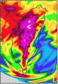
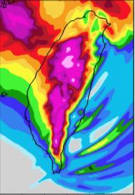
10 An example of real-time 2.5-km forecasts made at 7/10 12 UTC, for Soulik (2013), from 7/12 00 UTC to 7/13 18 UTC (t = h): Soulik (2013) Model forecasts of MSLP, sfc winds, and 1-h rainfall (mm) CReSS initial time Radar reflectivity composite (dbz) 10


 BS")

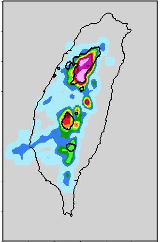
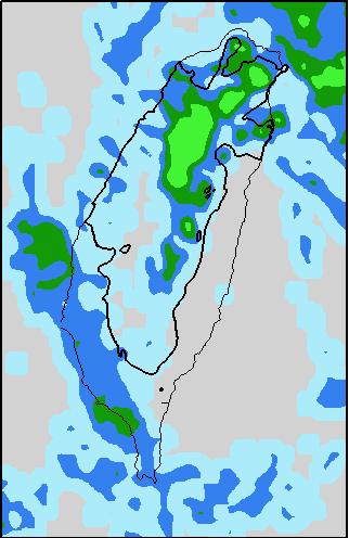
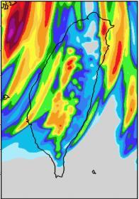
11 Real-time 2.5-km forecasts made at 7/10 12 UTC, for Soulik (2013): OBS 876 mm 7/ Z 7/ Z 7/ Z OBS M H FA FCST CReSS TS = H / (M + H + FA) BS = (H + FA) / (H + M) Day 1 Day 2 Day 3 Day 1 Day 2 Day 3 Threshold (mm) Threshold (mm) 11
: Most devastating typhoon,")
 in 2009 Total 48-h rainfall")


12 Other examples of high-resolution deterministic forecasts by CReSS: Morakot (2009): Most devastating typhoon, extreme rainfall up to 2855 mm Real-time twice daily 4-km CReSS forecasts (for 48 h) in 2009 Total 48-h rainfall (mm) from the run starting at 12 UTC 6 Aug 2009: Day-2 forecast from the run starting at 00 UTC 7 Aug 2009: OBS CReSS OBS CReSS 8/ Z 8/6 12Z-8/8 12Z (Wang et al. 2013: J. Hydro.) TS BS (Wang 2014: WAF) 24-h rainfall threshold (mm) 12

13 2.2 For 24-h Mei-yu QPFs: (3 Seasons) Total of 337 segments in Mei-yu period (May-Jun, excluding TC periods), classified into: Groups A, B, C, D, and X from the most to the least overall amount At least 10% of sites 50 mm (A), 25 mm (B), 10 mm (C), 1 mm (D), or otherwise (X, i.e., almost no rainfall) Group A+: 10% sites 130 mm, all from group A (roughly top 4% of all sample, with highest hazard potential) Total sample size: 337 segments ( points) May-Jun (excluding TCs) D X A A+: 13 (~4%) A group: 61 (27143) B group: 75 (33285) Compute scores after summing entries from all segments into one 2 x 2 contingency table C B C group: 88 (33846) D group: 67 (29443) X group: 46 (25250)
14 TS: Day 1 (0-24 h) Most rain Least rain Day 2 (24-48 h) Day 3 (48-72 h)

: Wang et al.")
15 3. How to Get Ensemble and Improve Further? 3.1 A Strategy to Obtain Cloud-Resolving QPFs at Longer Range Time-lagged ensemble (with comparable cost to multi-member ensemble): Wang et al. (2016, WAF), Wang et al. (2017, BAMS) 15


 Doksuri")
 8-day fcst domain Jelawat")
16 3.2 Usefulness of Daily Time-Lagged Ensemble in Domain size: 1860 km x 1360 km (744 x 544 pts), forecast range: 8 days Results from daily forecasts (t 0 = 00 UTC) for 6 TCs in Talim (TY1205) Doksuri (TY1206) Saola (TY1209) Tembin (TY1214) 8-day fcst domain Jelawat (TY1217) Kong-Rey (TY1315) 16

 (~24 members) Ensemble tracks from time-lagged runs")
17 Forecast for Typhoon Saola, starting at 00 UTC 30 Jul 2012 CWB best-track CReSS initial time TTFRI ensemble at 7/30 00 UTC (Computational demand: ~5 TTFRI-WRF members) (~10 km/h) (~24 members) Ensemble tracks from time-lagged runs 17


18 Comparison with TRMM-PR rain-rates for realistic scenarios: Same forecast starting at 00 UTC 30 Jul / UTC 7/ UTC 8/ UTC t = 29 h t = 45 h t = 52 h 7/ UTC 7/ UTC 8/ UTC 18
, Doksuri")

19 QPFs targeted at the most-rainy date, one from each of five typhoons: For Talim (6/20), Doksuri (6/28), and Saola (8/2): D8 D4 D6 Black, red, blue, and green box: TS 0.2 at 50, 100, 200, and 350 mm 19

, and Kong-Rey")

20 QPFs targeted at the most-rainy date, one from each of five typhoons: For Tembin (8/24), Jelawat (9/28), and Kong-Rey (8/29): D3 D6 D7 Black, red, blue, and green box: TS 0.2 at 50, 100, 200, and 350 mm 20
: A")

 Observed peak rainfall Wang et al.")
21 Threat score TS of a decent QPF made at the longest range for the most rainy date of each typhoon (from once daily QPFs): A decent QPF at a range beyond day-3 expect for Tembin Averaged range of such decent QPFs is on day 5.7! Day 7 Day 3 Day 6 Day 6 Day 4 Day 8 Rainfall threshold (mm, per 24 h) Observed peak rainfall Wang et al. (2016): WAF, Wang et al. (2017): BAMS 21
 Forecast for Kong-Rey, starting at 06 UTC 22 Aug 2013 CWB best-track TTFRI Kong-Rey (TY1315) CReSS initial time Focus: Ability to provide all possible scenarios at longer lead time")
22 3.3 Six-hourly Time-Lagged Ensemble for Three Typhoons First example: TS Kong-Rey (2013) Very weak and not expected to cause serious damages Most hazardous TY in 2013 (6 deaths and NTD 900 M in damage) Forecast for Kong-Rey, starting at 06 UTC 22 Aug 2013 CWB best-track TTFRI Kong-Rey (TY1315) CReSS initial time Focus: Ability to provide all possible scenarios at longer lead time 22


 available much earlier by")
23 Comparison of tracks with typical 24-member 3-day ensemble 00Z 22-00Z 25 Aug Current 24-member Ensemble at TTFRI First release at 00 UTC 27 Aug 2013 Black: OBS 00Z 25-18Z 28 Aug Tracks produced by timelagged ensemble: Before 00 UTC 25 Aug 2013: cover all possible scenarios After 00 UTC 25 Aug 2013: tracks converge toward the most-likely case Black: OBS Track (and QPF scenarios) available much earlier by time-lagged ensemble 23
 Last 13 members (8/26-28) (48-h rainfall) Wang et al. (2016): WAF, Wang et al.")
24 The produced 48-h QPFs (29-30 Aug) for Taiwan: Highly realistic rainfall scenario in association with each track due to cloud-resolving capability About 2/3 members indicate heavy rainfall potential over plains First 12 members (before 8/26 00Z) Last 13 members (8/26-28) (48-h rainfall) Wang et al. (2016): WAF, Wang et al. (2017): BAMS 24


 Last")
25 Probability (ensemble) information generated by the time-lagged ensemble: The evolving probabilities give forecasters a good sense of what to expect 100 mm 200 mm 350 mm 500 mm First 12 members (before 8/26 00Z) Last 13 members (8/26-28) 25
 7/10-11 12Z 7/11-12 12Z TTFRI 876 mm 8-day fcst domain CReSS initial time 7/12-13 12Z")
26 Second example: TY Soulik (2013): Second most hazardous TY in 2013 (after TS Kong-Rey) 3 deaths, NTD 1.5 B in damage Soulik (2013) 7/ Z 7/ Z TTFRI 876 mm 8-day fcst domain CReSS initial time 7/ Z 7/ Z 26

 7/6 00 UTC to 7/10 12 UTC Black:")


27 Comparison of tracks with typical 24-member 3-day ensemble Current 24-member Ensemble at TTFRI First release at 18 UTC 9 Jul 2013 Soulik (2013) 7/6 00 UTC to 7/10 12 UTC Black: OBS 7/13 00 Z Tracks produced by timelagged ensemble: Before 12 UTC 10 Jul 2013: comparable spread but more to the north After 12 UTC 10 Jul 2013: tracks converge toward BT 7/6 00 UTC to 7/12 18 UTC Black: OBS 7/13 00 Z Larger cross-track errors (in moving direction) prior to 10 July 27


28 The produced 24-h QPFs (7/ UTC) for Taiwan: 27 members total 7/6 00Z 7/6 06Z 7/6 12Z 7/6 18Z 7/7 00Z 7/7 06Z 7/7 12Z 7/7 18Z 7/8 00Z 7/8 06Z 7/8 12Z 7/8 18Z OBS 7/ Z 876 mm 7/9 00Z 7/9 06Z 7/9 12Z 7/9 18Z 7/10 00Z 7/10 06Z 7/10 12Z (24-h rainfall) 7/10 18Z 7/11 00Z 7/11 06Z 7/11 12Z 7/11 18Z 7/12 00Z 7/12 06Z 7/12 12Z 28


29 Probability (ensemble) information generated for Soulik: (black = OBS) 50 mm 100 mm 200 mm 300 mm 500 mm First 9 members before 7/8 06Z Middle 9 mem., 7/8 06Z- 7/10 06Z Last 9 members after 7/10 06Z 29


30 Third example: TY Soudelor (2015) Most hazardous TY in deaths, 4 missing, NTD 2.2 B in damage, 4 M houses no power Soudelor (2015) 8/ UTC 8/ UTC TTFRI 8-day fcst domain CReSS initial time 8/ UTC 8/ UTC 30


31 CReSS forecast made at 8/4 06 UTC for Soudelor, loop from 8/7 06 UTC to 8/8 12 UTC (t = h): Soudelor (2015) Model forecasts of MSLP, sfc winds, and 1-h rainfall (mm) CReSS initial time Radar reflectivity comp. (dbz) 8/7 06 UTC to 8/8 12 UTC 31


32 Comparison with TRMM-TMI T B (85v, 89v, 91v) for realistic TC structure: Same forecast starting at 06 UTC 4 Aug / UTC 8/ UTC 8/ UTC t = 60 h t = 76 h t = 94 h 8/ UTC 8/ UTC 8/ UTC 32


33 24-h QPFs and their comparison with the observation: OBS 8/ UTC 8/ UTC 8/ UTC CReSS t = h t = h t = h 33
 8/1 00 UTC to 8/4 00 UTC Black: OBS 8/7 00 Z Tracks produced by timelagged ensemble: Before")
 had speed (along-track) errors, too fast by 6-12 h")
34 Comparison of tracks with typical 24-member 3-day ensemble Current 24-member Ensemble at TTFRI First release at 00 UTC 5 Aug 2015 Soudelor (2013) 8/1 00 UTC to 8/4 00 UTC Black: OBS 8/7 00 Z Tracks produced by timelagged ensemble: Before 00 UTC 4 Aug 2015: cover all possible scenarios After 00 UTC 4 Aug 2015: tracks converge toward the most-likely case 8/1 00 UTC to 8/7 18 UTC 8/7 00 Z Black: OBS Early tracks (1-2 Aug) had speed (along-track) errors, too fast by 6-12 h 34


")


35 The produced 24-h QPFs (7/ UTC) for Taiwan: 29 members total 7/31 12Z 7/31 18Z 8/1 00Z 8/1 06Z 8/1 12Z 8/1 18Z 8/2 00Z OBS 8/7-8 12Z 8/2 06Z 8/2 12Z 8/2 18Z 8/3 00Z 8/3 06Z 8/3 12Z 8/3 18Z 8/4 00Z 8/4 06Z 8/4 12Z 8/4 18Z 8/5 00Z 8/5 06Z 8/5 12Z (24-h rainfall) 8/5 18Z 8/6 00Z 8/6 06Z 8/6 12Z 8/6 18Z 8/7 00Z 8/7 06Z 8/7 12Z 35


36 Probability (ensemble) information generated for Soudelor: (black = OBS) 50 mm 100 mm 200 mm 300 mm 500 mm First 10 members before 8/3 00Z Middle 10 mem., 8/3 00Z- 8/5 06Z Last 9 members after 8/5 06Z 36
37 Operational 2.5-km CReSS shows high skills in heavy-rainfall QPFs in Taiwan for both typhoon and mei-yu, not limited to 0-24 h but also in days 2-3 Significantly improved skill using CReSS at cloud-resolving resolution Better skill for top events than all events, not understood previously For mei-yu QPFs, TS > 0.15) through 500/200/130 mm on day 3/2/1 ~ Season Threshold 50 mm 130 mm 200 mm 350 mm 500 mm Typhoon Top 7% cases ( ) Mei-yu Top 4% cases ( ) 4. Conclusion and Summary Day 1 (0-24 h) Day 2 (24-48 h) Day 3 (48-72 h) Day 1 (0-24 h) Day 2 (24-48 h) Day 3 (48-72 h) Much higher predictability over terrain for systems linked to topography (e.g., topo. uplift), where high skill at high thresholds can be achieved Time-lagged ensemble allows for high-resolution, large fine-domain (for QPFs), and longer range (for lead time and preparation) simultaneously
: TC tracks converge as forecast uncertainty reduces, and the most-likely scenario emerges (which is, with high chances, known) High probability of heavy rainfall, highly realistic")
38 At longer range beyond 3-4 days: High forecast uncertainty and large spread in TC tracks Wide range of scenarios, including worse case for early preparation At shorter range as the TC approaches (within 3-4 days): TC tracks converge as forecast uncertainty reduces, and the most-likely scenario emerges (which is, with high chances, known) High probability of heavy rainfall, highly realistic in distribution due to strong topographic control Authority can then make adjustments for the most-likely scenario 38
39 --- The End --- Thanks for your for attention! Questions?
A Comparison between Hurricane WRF and TWRF in Typhoon Track and Rainfall Forecast over the western North Pacific
 A Comparison between Hurricane WRF and TWRF in Typhoon Track and Rainfall Forecast over the western North Pacific Chin-Cheng TSAI 1, Ling-Feng HSIAO 1, Der Song CHEN 2, Jian-Wen BAO 3 1 Taiwan Typhoon
Outline. Research Achievements
 Taiwan Typhoon and Flood Research Institute, National Applied Research Laboratories 11F., No.97, Sec. 1, Roosevelt Rd., Zhongzheng Dist., Taipei City 10093, Taiwan (R.O.C.) http://www.ttfri.narl.org.tw/eng/index.html
COSMIC GPS Radio Occultation and
 An Impact Study of FORMOSAT-3/ COSMIC GPS Radio Occultation and Dropsonde Data on WRF Simulations 27 Mei-yu season Fang-Ching g Chien Department of Earth Sciences Chien National and Taiwan Kuo (29), Normal
Performance of TANC (Taiwan Auto- Nowcaster) for 2014 Warm-Season Afternoon Thunderstorm
 for 2014 Warm-Season Afternoon Thunderstorm") Performance of TANC (Taiwan Auto- Nowcaster) for 2014 Warm-Season Afternoon Thunderstorm Wei-Peng Huang, Hui-Ling Chang, Yu-Shuang Tang, Chia-Jung Wu, Chia-Rong Chen Meteorological Satellite Center, Central
Performance of TANC (Taiwan Auto- Nowcaster) for 2014 Warm-Season Afternoon Thunderstorm Wei-Peng Huang, Hui-Ling Chang, Yu-Shuang Tang, Chia-Jung Wu, Chia-Rong Chen Meteorological Satellite Center, Central
The Use of GPS Radio Occultation Data for Tropical Cyclone Prediction. Bill Kuo and Hui Liu UCAR
 The Use of GPS Radio Occultation Data for Tropical Cyclone Prediction Bill Kuo and Hui Liu UCAR Current capability of the National Hurricane Center Good track forecast improvements. Errors cut in half
Using rainfall thresholds and ensemble precipitation forecasts to issue and improve urban inundation alerts
 Hydrol. Earth Syst. Sci., 20, 4731 4745, 2016 doi:10.5194/hess-20-4731-2016 Author(s) 2016. CC Attribution 3.0 License. Using rainfall thresholds and ensemble precipitation forecasts to issue and improve
Striving Sufficient Lead Time of Flood Forecasts via Integrated Hydro-meteorological Intelligence
 Striving Sufficient Lead Time of Flood Forecasts via Integrated Hydro-meteorological Intelligence Dong-Sin Shih Assistant Professor, National Chung Hsing University, Taiwan, Sep. 6, 2013 Outlines Introductions
Verification of ensemble and probability forecasts
 Verification of ensemble and probability forecasts Barbara Brown NCAR, USA bgb@ucar.edu Collaborators: Tara Jensen (NCAR), Eric Gilleland (NCAR), Ed Tollerud (NOAA/ESRL), Beth Ebert (CAWCR), Laurence Wilson
Reduction of the Radius of Probability Circle. in Typhoon Track Forecast
 Reduction of the Radius of Probability Circle in Typhoon Track Forecast Nobutaka MANNOJI National Typhoon Center, Japan Meteorological Agency Abstract RSMC Tokyo - Typhoon Center of the Japan Meteorological
Radiance Data Assimilation with an EnKF
 Radiance Data Assimilation with an EnKF Zhiquan Liu, Craig Schwartz, Xiangyu Huang (NCAR/MMM) Yongsheng Chen (York University) 4/7/2010 4th EnKF Workshop 1 Outline Radiance Assimilation Methodology Apply
Verification of nowcasts and short-range forecasts, including aviation weather
 Verification of nowcasts and short-range forecasts, including aviation weather Barbara Brown NCAR, Boulder, Colorado, USA WMO WWRP 4th International Symposium on Nowcasting and Very-short-range Forecast
Precipitation verification. Thanks to CMC, CPTEC, DWD, ECMWF, JMA, MF, NCEP, NRL, RHMC, UKMO
 Precipitation verification Thanks to CMC, CPTEC, DWD, ECMWF, JMA, MF, NCEP, NRL, RHMC, UKMO Outline 1) Status of WGNE QPF intercomparisons 2) Overview of the use of recommended methods for the verification
Statistical Characteristic of Heavy Rainfall Associated with Typhoons near Taiwan Based on the High-Density Automatic Rain Gauge Data
 1 2 Statistical Characteristic of Heavy Rainfall Associated with Typhoons near Taiwan Based on the High-Density Automatic Rain Gauge Data 3 4 Chun-Chieh Wu 1, Tzu-Hsiung Yen 1, Yi-Hsuan Huang 1, Cheng-Ku
Spatial Forecast Verification Methods
 Spatial Forecast Verification Methods Barbara Brown Joint Numerical Testbed Program Research Applications Laboratory, NCAR 22 October 2014 Acknowledgements: Tara Jensen, Randy Bullock, Eric Gilleland,
The Impact of Horizontal Resolution and Ensemble Size on Probabilistic Forecasts of Precipitation by the ECMWF EPS
 The Impact of Horizontal Resolution and Ensemble Size on Probabilistic Forecasts of Precipitation by the ECMWF EPS S. L. Mullen Univ. of Arizona R. Buizza ECMWF University of Wisconsin Predictability Workshop,
Impact of GPS RO Data on the Prediction of Tropical Cyclones
 Impact of GPS RO Data on the Prediction of Tropical Cyclones Ying-Hwa Kuo, Hui Liu, UCAR Ching-Yuang Huang, Shu-Ya Chen, NCU Ling-Feng Hsiao, Ming-En Shieh, Yu-Chun Chen, TTFRI Outline Tropical cyclone
The Impacts of GPSRO Data Assimilation and Four Ices Microphysics Scheme on Simulation of heavy rainfall Events over Taiwan during June 2012
 The Impacts of GPSRO Data Assimilation and Four Ices Microphysics Scheme on Simulation of heavy rainfall Events over Taiwan during 10-12 June 2012 Pay-Liam LIN, Y.-J. Chen, B.-Y. Lu, C.-K. WANG, C.-S.
Assessment of Ensemble Forecasts
 Assessment of Ensemble Forecasts S. L. Mullen Univ. of Arizona HEPEX Workshop, 7 March 2004 Talk Overview Ensemble Performance for Precipitation Global EPS and Mesoscale 12 km RSM Biases, Event Discrimination
Probabilistic Quantitative Precipitation Forecasts for Tropical Cyclone Rainfall
 Probabilistic Quantitative Precipitation Forecasts for Tropical Cyclone Rainfall WOO WANG CHUN HONG KONG OBSERVATORY IWTCLP-III, JEJU 10, DEC 2014 Scales of Atmospheric Systems Advection-Based Nowcasting
Denver International Airport MDSS Demonstration Verification Report for the Season
 Denver International Airport MDSS Demonstration Verification Report for the 2015-2016 Season Prepared by the University Corporation for Atmospheric Research Research Applications Division (RAL) Seth Linden
Comparison of Convection-permitting and Convection-parameterizing Ensembles
 Comparison of Convection-permitting and Convection-parameterizing Ensembles Adam J. Clark NOAA/NSSL 18 August 2010 DTC Ensemble Testbed (DET) Workshop Introduction/Motivation CAMs could lead to big improvements
Evaluation of Ensemble Icing Probability Forecasts in NCEP s SREF, VSREF and NARRE-TL Systems
 Evaluation of Ensemble Icing Probability Forecasts in NCEP s, V and Systems Binbin Zhou 1,2, Jun Du 2, Geoff DeMigo 2 and Robert Sallee 3 1. I.M. System Group 2. Environmental Modeling Center of NCEP 3.
Spatial forecast verification
 Spatial forecast verification Manfred Dorninger University of Vienna Vienna, Austria manfred.dorninger@univie.ac.at Thanks to: B. Ebert, B. Casati, C. Keil 7th Verification Tutorial Course, Berlin, 3-6
Adaptation for global application of calibration and downscaling methods of medium range ensemble weather forecasts
 Adaptation for global application of calibration and downscaling methods of medium range ensemble weather forecasts Nathalie Voisin Hydrology Group Seminar UW 11/18/2009 Objective Develop a medium range
Development Project High Resolution Numerical Prediction of Landfalling Typhoon Rainfall (tentative title)
") A Proposal for the WMO/WWRP Research and Development Project High Resolution Numerical Prediction of Landfalling Typhoon Rainfall (tentative title) Yihong Duan WGTMR Proposed in the side meeting of the
A Proposal for the WMO/WWRP Research and Development Project High Resolution Numerical Prediction of Landfalling Typhoon Rainfall (tentative title) Yihong Duan WGTMR Proposed in the side meeting of the
Weather Hazard Modeling Research and development: Recent Advances and Plans
 Weather Hazard Modeling Research and development: Recent Advances and Plans Stephen S. Weygandt Curtis Alexander, Stan Benjamin, Geoff Manikin*, Tanya Smirnova, Ming Hu NOAA Earth System Research Laboratory
The Impacts of GPS Radio Occultation Data on the Analysis and Prediction of Tropical Cyclones. Bill Kuo, Xingqin Fang, and Hui Liu UCAR COSMIC
 The Impacts of GPS Radio Occultation Data on the Analysis and Prediction of Tropical Cyclones Bill Kuo, Xingqin Fang, and Hui Liu UCAR COSMIC GPS Radio Occultation α GPS RO observations advantages for
Extracting probabilistic severe weather guidance from convection-allowing model forecasts. Ryan Sobash 4 December 2009 Convection/NWP Seminar Series
 Extracting probabilistic severe weather guidance from convection-allowing model forecasts Ryan Sobash 4 December 2009 Convection/NWP Seminar Series Identification of severe convection in high-resolution
Hazard assessment based on radar-based rainfall nowcasts at European scale The HAREN project
 Hazard assessment based on radar-based rainfall nowcasts at European scale The HAREN project Marc Berenguer, Daniel Sempere-Torres 3 OPERA radar mosaic OPERA radar mosaic: 213919 133 Precipitation observations
Dynamical Statistical Seasonal Prediction of Atlantic Hurricane Activity at NCEP
 Dynamical Statistical Seasonal Prediction of Atlantic Hurricane Activity at NCEP Hui Wang, Arun Kumar, Jae Kyung E. Schemm, and Lindsey Long NOAA/NWS/NCEP/Climate Prediction Center Fifth Session of North
2012 and changes to the Rapid Refresh and HRRR weather forecast models
 2012 and 2013-15 changes to the Rapid Refresh and HRRR weather forecast models 31 October 2012 Stan Benjamin Steve Weygandt Curtis Alexander NOAA Earth System Research Laboratory Boulder, CO FPAW - 2012
Categorical Verification
 Forecast M H F Observation Categorical Verification Tina Kalb Contributions from Tara Jensen, Matt Pocernich, Eric Gilleland, Tressa Fowler, Barbara Brown and others Finley Tornado Data (1884) Forecast
CONTRIBUTION OF ENSEMBLE FORECASTING APPROACHES TO FLASH FLOOD NOWCASTING AT GAUGED AND UNGAUGED CATCHMENTS
 CONTRIBUTION OF ENSEMBLE FORECASTING APPROACHES TO FLASH FLOOD NOWCASTING AT GAUGED AND UNGAUGED CATCHMENTS Maria-Helena Ramos 1, Julie Demargne 2, Pierre Javelle 3 1. Irstea Antony, 2. Hydris Hydrologie,
DATA FUSION NOWCASTING AND NWP
 DATA FUSION NOWCASTING AND NWP Brovelli Pascal 1, Ludovic Auger 2, Olivier Dupont 1, Jean-Marc Moisselin 1, Isabelle Bernard-Bouissières 1, Philippe Cau 1, Adrien Anquez 1 1 Météo-France Forecasting Department
Application of Mean Recentering Scheme to Improve the Typhoon Track Forecast: A Case Study of Typhoon Nanmadol (2011) Chih-Chien Chang, Shu-Chih Yang
 Chih-Chien Chang, Shu-Chih Yang") 6 th EnKF workshop Application of Mean Recentering Scheme to Improve the Typhoon Track Forecast: A Case Study of Typhoon Nanmadol (2011) Chih-Chien Chang, Shu-Chih Yang National Central University, Taiwan
6 th EnKF workshop Application of Mean Recentering Scheme to Improve the Typhoon Track Forecast: A Case Study of Typhoon Nanmadol (2011) Chih-Chien Chang, Shu-Chih Yang National Central University, Taiwan
Mesoscale Ensemble Data Assimilation: Opportunities and Challenges. Fuqing Zhang Penn State University
 Mesoscale Ensemble Data Assimilation: Opportunities and Challenges Fuqing Zhang Penn State University Mesoscale EnKF: some incomplete background 1 st proposed by Evensen (1994); Houtekamer and Micthell
Heavy Rainfall Event of June 2013
 Heavy Rainfall Event of 10-11 June 2013 By Richard H. Grumm National Weather Service State College, PA 1. Overview A 500 hpa short-wave moved over the eastern United States (Fig. 1) brought a surge of
The GNSS-RO Data Impact on the Typhoon Predictions by MPAS-GSI Model
 The GNSS-RO Data Impact on the Typhoon Predictions by MPAS-GSI Model 1 Shu-Ya Chen, 1,2 Cheng-Peng Shih, 2,3 Ching-Yuang Huang, 2 Wen-Hsin Teng, and 1 Yang-Cheng Huang 1 GPS Science and Application Research
Severe storm forecast guidance based on explicit identification of convective phenomena in WRF-model forecasts
 Severe storm forecast guidance based on explicit identification of convective phenomena in WRF-model forecasts Ryan Sobash 10 March 2010 M.S. Thesis Defense 1 Motivation When the SPC first started issuing
Using time-lag ensemble techniques to assess behaviour of high-resolution precipitation forecasts
 Using time-lag ensemble techniques to assess behaviour of high-resolution precipitation forecasts Marion Mittermaier 3 rd Int l Verification Methods Workshop, ECMWF, 31/01/2007 Crown copyright Page 1 Outline
High Resolution Ensemble Prediction of Typhoon Morakot (2009) May 11, 2011
 May 11, 2011") High Resolution Ensemble Prediction of Typhoon Morakot (2009) Ying-Hwa Kuo 1,* and Xingqin Fang 1,2 1 National Center for Atmospheric Research, Boulder, Colorado, USA 2 Department of Atmospheric Sciences,
High Resolution Ensemble Prediction of Typhoon Morakot (2009) Ying-Hwa Kuo 1,* and Xingqin Fang 1,2 1 National Center for Atmospheric Research, Boulder, Colorado, USA 2 Department of Atmospheric Sciences,
OBJECTIVE CALIBRATED WIND SPEED AND CROSSWIND PROBABILISTIC FORECASTS FOR THE HONG KONG INTERNATIONAL AIRPORT
 P 333 OBJECTIVE CALIBRATED WIND SPEED AND CROSSWIND PROBABILISTIC FORECASTS FOR THE HONG KONG INTERNATIONAL AIRPORT P. Cheung, C. C. Lam* Hong Kong Observatory, Hong Kong, China 1. INTRODUCTION Wind is
Analysis and accuracy of the Weather Research and Forecasting Model (WRF) for Climate Change Prediction in Thailand
 for Climate Change Prediction in Thailand") ก ก ก 19 19 th National Convention on Civil Engineering 14-16 2557. ก 14-16 May 2014, Khon Kaen, THAILAND ก ก ก ก ก WRF Analysis and accuracy of the Weather Research and Forecasting Model (WRF) for Climate
ก ก ก 19 19 th National Convention on Civil Engineering 14-16 2557. ก 14-16 May 2014, Khon Kaen, THAILAND ก ก ก ก ก WRF Analysis and accuracy of the Weather Research and Forecasting Model (WRF) for Climate
ARW/EnKF performance for the 2009 Hurricane Season
 ARW/EnKF performance for the 2009 Hurricane Season Ryan D. Torn, Univ. at Albany, SUNY Chris Davis, Steven Cavallo, Chris Snyder, Wei Wang, James Done, NCAR/MMM 4 th EnKF Workshop 8 April 2010, Rensselaerville,
Impact of FORMOSAT 3/COSMIC Radio Occultation. near Taiwan
 Impact of FORMOSAT 3/COSMIC Radio Occultation Data on Predictions i of Typhoon and Mei yu Fronts near Taiwan CHING YUANG HUANG 1,2, CHAN SENG WONG 1, CHIEN JU WANG 2, and CHIN CHENG TSAI 2 1 Department
Object-oriented verification of WRF forecasts from 2005 SPC/NSSL Spring Program
 Object-oriented verification of WRF forecasts from 2005 SPC/NSSL Spring Program Mike Baldwin Purdue University References Baldwin et al. (2005): Development of an automated classification procedure for
Feature-specific verification of ensemble forecasts
 Feature-specific verification of ensemble forecasts www.cawcr.gov.au Beth Ebert CAWCR Weather & Environmental Prediction Group Uncertainty information in forecasting For high impact events, forecasters
Impact assessment on disasters
 The 5th International Coordination Group (ICG) Meeting GEOSS Asian Water Cycle Initiative (AWCI), Dec. 16, 2009. Impact assessment on disasters Eiichi Nakakita Disaster Prevention Research Institute Kyoto
Application and verification of ECMWF products 2013
 Application and verification of EMWF products 2013 Hellenic National Meteorological Service (HNMS) Flora Gofa and Theodora Tzeferi 1. Summary of major highlights In order to determine the quality of the
09 December 2005 snow event by Richard H. Grumm National Weather Service Office State College, PA 16803
 09 December 2005 snow event by Richard H. Grumm National Weather Service Office State College, PA 16803 1. INTRODUCTION A winter storm produced heavy snow over a large portion of Pennsylvania on 8-9 December
Assimilate W88D Doppler Vr for Humberto 05
 Assimilate W88D Doppler Vr for Humberto 05 WRF/EnKF Forecast vs. Observations vs. 3DVAR Min SLP Max wind The WRF/3DVAR (as a surrogate of operational algorithm) assimilates the same radar data but without
Using a high-resolution ensemble modeling method to inform risk-based decision-making at Taylor Park Dam, Colorado
 Using a high-resolution ensemble modeling method to inform risk-based decision-making at Taylor Park Dam, Colorado Michael J. Mueller 1, Kelly Mahoney 2, Kathleen Holman 3, David Gochis 4 1 Cooperative
Convective-scale NWP for Singapore
 Convective-scale NWP for Singapore Hans Huang and the weather modelling and prediction section MSS, Singapore Dale Barker and the SINGV team Met Office, Exeter, UK ECMWF Symposium on Dynamical Meteorology
Toward improved initial conditions for NCAR s real-time convection-allowing ensemble. Ryan Sobash, Glen Romine, Craig Schwartz, and Kate Fossell
 Toward improved initial conditions for NCAR s real-time convection-allowing ensemble Ryan Sobash, Glen Romine, Craig Schwartz, and Kate Fossell Storm-scale ensemble design Can an EnKF be used to initialize
At the start of the talk will be a trivia question. Be prepared to write your answer.
 Operational hydrometeorological forecasting activities of the Australian Bureau of Meteorology Thomas Pagano At the start of the talk will be a trivia question. Be prepared to write your answer. http://scottbridle.com/
Description of the case study
 Description of the case study During the night and early morning of the 14 th of July 011 the significant cloud layer expanding in the West of the country and slowly moving East produced precipitation
TC/PR/RB Lecture 3 - Simulation of Random Model Errors
 TC/PR/RB Lecture 3 - Simulation of Random Model Errors Roberto Buizza (buizza@ecmwf.int) European Centre for Medium-Range Weather Forecasts http://www.ecmwf.int Roberto Buizza (buizza@ecmwf.int) 1 ECMWF
Bias correction of Dynamic Downscaled Typhoons Rainfall Data for Hydrological Applications
 Bias correction of Dynamic Downscaled Typhoons Rainfall Data for Hydrological Applications National Science and Technology Center for Disaster Reduction Dr. Yuan-Fong Su 27 May 2015 2015 International
Xinhua Liu National Meteorological Center (NMC) of China Meteorological Administration (CMA)
 of China Meteorological Administration (CMA)") The short-time forecasting and nowcasting technology of severe convective weather for aviation meteorological services in China Xinhua Liu National Meteorological Center (NMC) of China Meteorological Administration
The short-time forecasting and nowcasting technology of severe convective weather for aviation meteorological services in China Xinhua Liu National Meteorological Center (NMC) of China Meteorological Administration
Downscaling of ECMWF seasonal integrations by RegCM
 Downscaling of ECMWF seasonal integrations by RegCM Čedo Branković and Mirta Patarčić Croatian Meteorological and Hydrological Service Grič 3, 10000 Zagreb, Croatia (Thanks to Paul Dando and Manuel Fuentes
Update on CoSPA Storm Forecasts
 Update on CoSPA Storm Forecasts Haig August 2, 2011 This work was sponsored by the Federal Aviation Administration under Air Force Contract No. FA8721-05-C-0002. Opinions, interpretations, conclusions,
Nowcasting techniques in use for severe weather operation in NMC/CMA
 WWRP NMRWG Buenos Aires Aug 2017 Nowcasting techniques in use for severe weather operation in NMC/CMA Jianjie WANG National Meteorological Center, CMA Cascading Weather Forecasting Process --- different
An Application of Hydrometeorological Information
 An Application of Hydrometeorological Information Weather-proof Café: Hydro-meteorological information in managing weather risks 17 19 November 2012 National Taiwan University, Chinese Taipei Nikos Viktor
Convection-Resolving NWP with WRF. Section coordinator Ming Xue University of Oklahoma
 Convection-Resolving NWP with WRF Section coordinator Ming Xue University of Oklahoma Convection-resolving NWP Is NWP that explicitly treats moist convective systems ranging from organized MCSs to individual
Operational Use of Scatterometer Winds at JMA
 Operational Use of Scatterometer Winds at JMA Masaya Takahashi Numerical Prediction Division, Japan Meteorological Agency (JMA) 10 th International Winds Workshop, Tokyo, 26 February 2010 JMA Outline JMA
High Resolution Numerical Weather Prediction for High Impact and Extreme Weather Events in 2014 across Southern California
 High Resolution Numerical Weather Prediction for High Impact and Extreme Weather Events in 2014 across Southern California Alex Tardy Alexander.Tardy@noaa.gov NWS San Diego Warning Coordination Meteorologist
SIXTH INTERNATIONAL WORKSHOP on TROPICAL CYCLONES. Working Group: Phillipe Caroff, Jeff Callaghan, James Franklin, Mark DeMaria
 WMO/CAS/WWW Topic 0.1: Track forecasts SIXTH INTERNATIONAL WORKSHOP on TROPICAL CYCLONES Rapporteur: E-mail: Lixion A. Avila NOAA/National Hurricane Center 11691 SW 17th Street Miami, FL 33165-2149, USA
Evaluation of Satellite Precipitation Products over the Central of Vietnam
 Evaluation of Satellite Precipitation Products over the Central of Vietnam Long Trinh-Tuan (1), Jun Matsumoto (1,2), Thanh Ngo-Duc (3) (1) Department of Geography, Tokyo Metropolitan University, Japan.
Report on stay at ZAMG
 Report on stay at ZAMG Viena, Austria 13.05.2013 05.07.2013 Simona Tascu NMA, Romania Supervised by: Yong Wang and Theresa Gorgas Introduction The goal of the present stay was to develop and optimize the
Introduction to NCEP's time lagged North American Rapid Refresh Ensemble Forecast System (NARRE-TL)
") Introduction to NCEP's time lagged North American Rapid Refresh Ensemble Forecast System (NARRE-TL) Binbin Zhou 1,2, Jun Du 2, Geoff Manikin 2 & Geoff DiMego 2 1. I.M. System Group 2. EMC/NCEP/NWS/NOAA
Introduction to NCEP's time lagged North American Rapid Refresh Ensemble Forecast System (NARRE-TL) Binbin Zhou 1,2, Jun Du 2, Geoff Manikin 2 & Geoff DiMego 2 1. I.M. System Group 2. EMC/NCEP/NWS/NOAA
ICAM conference 6 June 2013 Kranjska Gora (SLO) Objective forecast verification of WRF compared to ALARO and the derived INCA-FVG outputs
 Objective forecast verification of WRF compared to ALARO and the derived INCA-FVG outputs") ICAM conference 6 June 2013 Kranjska Gora (SLO) Objective forecast verification of WRF compared to ALARO and the derived INCA-FVG outputs Arturo Pucillo & Agostino Manzato OSMER ARPA FVG 33040 Visco (UD),
ICAM conference 6 June 2013 Kranjska Gora (SLO) Objective forecast verification of WRF compared to ALARO and the derived INCA-FVG outputs Arturo Pucillo & Agostino Manzato OSMER ARPA FVG 33040 Visco (UD),
Summary of 2006 NW Pacific Typhoon Season and Verification of Authors Seasonal Forecasts
 Summary of 2006 NW Pacific Typhoon Season and Verification of Authors Seasonal Forecasts Issued: 10th January 2007 by Professor Mark Saunders and Dr Adam Lea Benfield UCL Hazard Research Centre, UCL (University
Climate Variability and Prediction over West and Central Africa related to ITCZ Fluctuations.
 Climate Variability and Prediction over West and Central Africa related to ITCZ Fluctuations. P. Moudi Igri, Vondou Derbetini, Tanessong Roméo, Mkankam Kamga, Mbarga Assomo University of Yaounde I, Douala
Nesting and LBCs, Predictability and EPS
 Nesting and LBCs, Predictability and EPS Terry Davies, Dynamics Research, Met Office Nigel Richards, Neill Bowler, Peter Clark, Caroline Jones, Humphrey Lean, Ken Mylne, Changgui Wang copyright Met Office
Spatial verification of NWP model fields. Beth Ebert BMRC, Australia
 Spatial verification of NWP model fields Beth Ebert BMRC, Australia WRF Verification Toolkit Workshop, Boulder, 21-23 February 2007 New approaches are needed to quantitatively evaluate high resolution
THE DECORRELATION SCALE: METHODOLOGY AND APPLICATION FOR PRECIPITATION FORECASTS
 THE DECORRELATION SCALE: METHODOLOGY AND APPLICATION FOR PRECIPITATION FORECASTS Madalina Surcel, Isztar Zawadzki and M. K. Yau Thanking Adam Clark (NSSL), Ming Xue (OU, CAPS) and Fanyou Kong (CAPS) for
FLORA: FLood estimation and forecast in complex Orographic areas for Risk mitigation in the Alpine space
 Natural Risk Management in a changing climate: Experiences in Adaptation Strategies from some European Projekts Milano - December 14 th, 2011 FLORA: FLood estimation and forecast in complex Orographic
Recent advances in Tropical Cyclone prediction using ensembles
 Recent advances in Tropical Cyclone prediction using ensembles Richard Swinbank, with thanks to Many colleagues in Met Office, GIFS-TIGGE WG & others HC-35 meeting, Curacao, April 2013 Recent advances
Verifying Ensemble Forecasts Using A Neighborhood Approach
 Verifying Ensemble Forecasts Using A Neighborhood Approach Craig Schwartz NCAR/MMM schwartz@ucar.edu Thanks to: Jack Kain, Ming Xue, Steve Weiss Theory, Motivation, and Review Traditional Deterministic
Hurricane Harvey the Name says it all. by Richard H. Grumm and Charles Ross National Weather Service office State College, PA
 Hurricane Harvey the Name says it all by Richard H. Grumm and Charles Ross National Weather Service office State College, PA 16803. 1. Overview Hurricane Harvey crossed the Texas coast (Fig. 1) as a category
Verification and performance measures of Meteorological Services to Air Traffic Management (MSTA)
") Verification and performance measures of Meteorological Services to Air Traffic Management (MSTA) Background Information on the accuracy, reliability and relevance of products is provided in terms of verification
Verification and performance measures of Meteorological Services to Air Traffic Management (MSTA) Background Information on the accuracy, reliability and relevance of products is provided in terms of verification
Global Flood Alert System based on satellite derived rainfall data -Targeting the era of Global Precipitation Measurement (GPM)-
-") Global Flood Alert System based on satellite derived rainfall data -Targeting the era of Global Precipitation Measurement (GPM)- Riko Oki, Misako Kachi (JAXA/EORC) Kazuhiko Fukami (PWRI) and Kazuo Umeda
Global Flood Alert System based on satellite derived rainfall data -Targeting the era of Global Precipitation Measurement (GPM)- Riko Oki, Misako Kachi (JAXA/EORC) Kazuhiko Fukami (PWRI) and Kazuo Umeda
Climate Forecast System (CFS) Preliminary review of 2015 CFS anomaly forecasts of precipitation and severe weather Greg Carbin, NOAA/NWS/SPC
 Preliminary review of 2015 CFS anomaly forecasts of precipitation and severe weather Greg Carbin, NOAA/NWS/SPC") Climate Forecast System (CFS) Preliminary review of 2015 CFS anomaly forecasts of precipitation and severe weather Greg Carbin, NOAA/NWS/SPC Climate Forecast System (CFS) Severe 2015-16 Updates Dashboard
Climate Forecast System (CFS) Preliminary review of 2015 CFS anomaly forecasts of precipitation and severe weather Greg Carbin, NOAA/NWS/SPC Climate Forecast System (CFS) Severe 2015-16 Updates Dashboard
WxChallenge Model Output Page Tutorial
 WxChallenge Model Output Page Tutorial Brian Tang University at Albany - SUNY 9/25/12 http://www.atmos.albany.edu/facstaff/tang/forecast/ Clicking on square brings up graphic for the specified variable
A Preliminary Exploration of the Upper Bound of Tropical Cyclone Intensification
 A Preliminary Exploration of the Upper Bound of Tropical Cyclone Intensification Jonathan L. Vigh (NCAR/RAL) Kerry Emanuel (MIT) Mrinal K. Biswas (NCAR/RAL) Eric A. Hendricks (Naval Postgraduate School)
Tropical Cyclone Initialization with Dynamical and Physical constraints derived from Satellite data
 International Workshop on Rapid Change Phenomena in Tropical Cyclones Haikou China, 5 9 November 2012 Tropical Cyclone Initialization with Dynamical and Physical constraints derived from Satellite data
Briefing on the WMO Support to Viet Nam to cope with Typhoon Haiyan
 WMO Briefing on the WMO Support to Viet Nam to cope with Typhoon Haiyan A Case of WMO Emergency Response Typhoon Haiyan trajectory Background Typhoon Haiyan remained strong after devastating the Philippines
Near-surface weather prediction and surface data assimilation: challenges, development, and potential data needs
 Near-surface weather prediction and surface data assimilation: challenges, development, and potential data needs Zhaoxia Pu Department of Atmospheric Sciences University of Utah, Salt Lake City, Utah,
Application and verification of the ECMWF products Report 2007
 Application and verification of the ECMWF products Report 2007 National Meteorological Administration Romania 1. Summary of major highlights The medium range forecast activity within the National Meteorological
Five years of limited-area ensemble activities at ARPA-SIM: the COSMO-LEPS system
 Five years of limited-area ensemble activities at ARPA-SIM: the COSMO-LEPS system Andrea Montani, Chiara Marsigli and Tiziana Paccagnella ARPA-SIM Hydrometeorological service of Emilia-Romagna, Italy 11
Ensemble Prediction Systems
 Ensemble Prediction Systems Eric Blake National Hurricane Center 7 March 2017 Acknowledgements to Michael Brennan 1 Question 1 What are some current advantages of using single-model ensembles? A. Estimates
LIST OF TABLES Table 1. Table 2. Table 3. Table 4.
 LIST OF TABLES Table. Dataset names, their versions, and variables used in this study. The algorithm names (GPROF, GPROF7, and GSMaP) are added in the parenthesis after each TMI rainfall dataset. This
Towards a Definitive High- Resolution Climate Dataset for Ireland Promoting Climate Research in Ireland
 Towards a Definitive High- Resolution Climate Dataset for Ireland Promoting Climate Research in Ireland Jason Flanagan, Paul Nolan, Christopher Werner & Ray McGrath Outline Project Background and Objectives
Global Flash Flood Forecasting from the ECMWF Ensemble
 Global Flash Flood Forecasting from the ECMWF Ensemble Calumn Baugh, Toni Jurlina, Christel Prudhomme, Florian Pappenberger calum.baugh@ecmwf.int ECMWF February 14, 2018 Building a Global FF System 1.
Upgrade of JMA s Typhoon Ensemble Prediction System
 Upgrade of JMA s Typhoon Ensemble Prediction System Masayuki Kyouda Numerical Prediction Division, Japan Meteorological Agency and Masakazu Higaki Office of Marine Prediction, Japan Meteorological Agency
Winter Storm of 15 December 2005 By Richard H. Grumm National Weather Service Office State College, PA 16803
 Winter Storm of 15 December 2005 By Richard H. Grumm National Weather Service Office State College, PA 16803 1. INTRODUCTION A complex winter storm brought snow, sleet, and freezing rain to central Pennsylvania.
Status and Plans of using the scatterometer winds in JMA's Data Assimilation and Forecast System
 Status and Plans of using the scatterometer winds in 's Data Assimilation and Forecast System Masaya Takahashi¹ and Yoshihiko Tahara² 1- Numerical Prediction Division, Japan Meteorological Agency () 2-
Typhoon Relocation in CWB WRF
 Typhoon Relocation in CWB WRF L.-F. Hsiao 1, C.-S. Liou 2, Y.-R. Guo 3, D.-S. Chen 1, T.-C. Yeh 1, K.-N. Huang 1, and C. -T. Terng 1 1 Central Weather Bureau, Taiwan 2 Naval Research Laboratory, Monterey,
MESO-NH cloud forecast verification with satellite observation
 MESO-NH cloud forecast verification with satellite observation Jean-Pierre CHABOUREAU Laboratoire d Aérologie, University of Toulouse and CNRS, France http://mesonh.aero.obs-mip.fr/chaboureau/ DTC Verification
Comparison of the NCEP and DTC Verification Software Packages
 Comparison of the NCEP and DTC Verification Software Packages Point of Contact: Michelle Harrold September 2011 1. Introduction The National Centers for Environmental Prediction (NCEP) and the Developmental