The Use of GPS Radio Occultation Data for Tropical Cyclone Prediction. Bill Kuo and Hui Liu UCAR
|
|
|
- Alexis Benson
- 5 years ago
- Views:
Transcription


1 The Use of GPS Radio Occultation Data for Tropical Cyclone Prediction Bill Kuo and Hui Liu UCAR


2 Current capability of the National Hurricane Center Good track forecast improvements. Errors cut in half in 15 years. Skill of 48h forecast as good as 24-h forecast 10 years ago. No improvement in intensity forecast. Off by 2 categories 5-10% of the time.

3 2011 Preliminary NHC Verifications ECMWF and GFS did well (again). ECMWF beat consensus at longer ranges. TVCA beat FSSE. AEMI not as good as GFSI, even at 5 days. GFDL and HWRF middle of the pack. NGPS, CMC, UKMET trailed.
4 NOAA Hurricane Forecast Improvement Project (HFIP) 10-Year Goals: Reduce average track error by 50% for day 1 through 5 Reduce average intensity error by 50% for day 1 through 5 Increase the probability of detection (POD) for rapid intensity change to 90% at Day 1 decreasing linearly to 60% at day 5, and decrease the false alarm ratio (FAR) for rapid intensity change to 10% for day 1 increasing linearly to 30% at day 5. The focus on rapid intensity change is the highest forecast challenge indentified by the National Hurricane Center. Extend the lead time for hurricane forecasts out to Day 7 (with accuracy of Day 5 forecasts in 2003). 5-Year Goals: Reduce track and intensity forecast errors by 20%
. Larger difference over Western Pacific is noted.")
5 Differences between ECMWF and GFS/EnKF for 200 mb wind, averaged from 7/26 9/27, From Hamill et al (2011). Larger difference over Western Pacific is noted.
6 GPS RO observations advantages for weather analysis and prediction There are considerable uncertainties in global analyses over data void regions (e.g., where there are few or no radiosondes), despite the fact that most global analyses now make use of satellite observations. GPS RO missions (such as COSMIC) can be designed to have globally uniform distribution (not limited by oceans, or high topography). The accuracy of GPS RO is compatible or better than radiosonde, and can be used to calibrate other observing systems. GPS RO observations are of high vertical resolution and high accuracy. GPS RO is an active sensor, and provides information that other satellite observing systems could not provide GSP RO provide valuable information on the 3D distribution of moisture over the tropics, which is important for typhoon prediction.
7 Challenges for Tropical Cyclone Prediction Some of the current GPS RO missions do not provide much data in the lower troposphere. There are still significant uncertainties and challenges for GPS RO to provide accurate measurement in the lowest 2 km of the tropical troposphere. How would this impact tropical cyclone prediction?
8 COSMIC and Metop/GRAS Comparisons With ECMWF - Tropics, Jul-Dec 2009 Metop/COSMIC Bending Angles - Metop/GRAS processed down to first data gap Metop COSMIC Tropics Jul-Dec Metop/GRAS profiles have worse penetration than COSMIC - Metop/GRAS BA s negatively biased by several percent in lower troposphere Courtesy of Bill Schreiner


9 Hurrican Ernesto: Formed: 25 August 2006 Reached Hurricane strength: 27 August Dissipated: 1 September :50 UTC 27 August 2006 Picture taken by MODIS, 250 m resolution
10 WRF/DART ensemble assimilation of COSMIC GPSRO soundings WRF/DART ensemble Kalman filter data assimilation system 36-km, 32-members, 5-day assimilation Assimilation of 178 COSMIC GPSRO soundings (with nonlocal obs operator, Sokolovskiey et al) plus satellite cloud-drift winds Independent verification by ~100 dropsondes. 178 COSMIC GPSRO soundings during August 2006 From Liu et al. (2011)
11 Experiment Design Name Conventional data GPS RO NODA No No Continuous forecast ONLY No Yes GPS only ONLY6km No Yes above 6 km GPS only above 6 km ONLY2km No Yes above 2 km GPS only above 2 km CTRL Yes No Convectional RO Yes Yes Conventional + GPS RO6km Yes Yes above 6 km Convectional + GPS 6km RO2km Yes Yes above 2 km Convectional + GPS 2km > The first four experiments try to identify the impact of GPS data in a clean setting (without the use of any other data) > The second four experiments assess the impact of GPS RO data in a more realistic operational setting. > Conventional data includes radiosondes, surface, aircraft reports, satellite cloud track winds, no radiance.
12 Experiment Design Name Conventional data GPS RO NODA No No Continuous forecast ONLY No Yes GPS only ONLY6km No Yes above 6 km GPS only above 6 km ONLY2km No Yes above 2 km GPS only above 2 km CTRL Yes No Convectional RO Yes Yes Conventional + GPS RO6km Yes Yes above 6 km Convectional + GPS 6km RO2km Yes Yes above 2 km Convectional + GPS 2km > The first four experiments try to identify the impact of GPS data in a clean setting (without the use of any other data) > The second four experiments assess the impact of GPS RO data in a more realistic operational setting. > Conventional data includes radiosondes, surface, aircraft reports, satellite cloud track winds, no radiance.
 Where Ernesto formed at 0000 UTC 25 August Convergence and convection in Ernesto s genesis")
13 Analysis of 850 hpa Wind and Total Column Cloud Water (06Z August 23, 36 hours before Ernesto s genesis, GPSonly run) Where Ernesto formed at 0000 UTC 25 August Convergence and convection in Ernesto s genesis area.
14 Analysis Increments of Q and T (GPSonly run) (850 hpa, August 23, 2 days before Ernesto s genesis) Temperature increment is small; Water vapor increment is large.
15 2-hour Forecast Difference of GPSonly-NODA (700 hpa) Water vapor 06Z 23 August Wind 00Z 24 August 00Z 25 August Ernesto s genesis time
16 Analysis Increments of Q (Only run) (850 hpa, 06Z August 23, 2 days before Ernesto s genesis)
17 Analysis Increments of Q (Only2km run) (850 hpa, 06Z August 23, 2 days before Ernesto s genesis)
 Only - NODA 06Z 23")

18 2-hour Water Vapor Differences (700 hpa) Only - NODA 06Z 23 August Only6km - NODA 00Z 24 August 00Z 25 August Ernesto s genesis time
19 Analysis Increments of Wind (Only run) (August 23, 2 days before Ernesto s genesis, m/s) 250 hpa 700 hpa Strong correlation between GPS RO data in the lower troposphere and winds at all levels.
20 Analysis Increments of Wind (Only2km run) (August 23, 2 days before Ernesto s genesis, m/s) 250 hpa 700 hpa

21 Analysis Increments of Wind (Only6km run) (August 23, 2 days before Ernesto s genesis, m/s) 250 hpa 700 hpa Strong correlation between GPS in the lower troposphere and winds at all levels.
22 Assimilation Experiments of RO and Conventional Data CTRL (NO GPS) run: Assimilate conventional data. RO6km run: Add RO refractivity data only higher than 6km RO2km run: Add RO refractivity data only higher than 2km 6km. RO run: Add RO refractivity data of all levels. Non-local RO refractivity operator is used. Radiance is not assimilated in these experiments.


")
23 Analyses of SLP and 1000 hpa Vorticity (00UTC 25 August) CTRL RO6km RO
 CTRL")
24 Analyses of SLP and 1000 hpa Vorticity (00UTC 25 August) CTRL RO2km RO

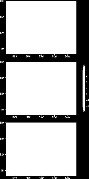

25 Water vapor Analysis Difference at 700 mb (00UTC 25 August) RO6km-CTRL RO2km- CTRL RO-CTRL
 CTRL GPS>6k")
26 48h-forecast of Track errors and SLP Intensity (00UTC 25 August) CTRL GPS>6k m GPS
27 Summary of Ernesto Study Assimilation of GPS RO data adds moisture in the lower troposphere, and produces noticeable wind increments, consistent with the convective environment. GPS RO data in the lower troposphere is crucial for creating a favorable environment for hurricane genesis. If we miss the bottom 6km, we will fail to capture hurricane genesis. The bottom 2km is also important. Assimilation of GPS RO data produced improved analysis and subsequent forecasts both in terms of track and intensity.
28 Verification of WRF/DART analysis by about 100 dropsondes during the Ernesto genesis stage.
 1 hour 3 hour 6 hour")
29 FORMOSAT-7/COSMIC-2 Soundings GPS and GLONASS ) 1 hour 3 hour 6 hour 24 hour
30 FORMOSAT-7/COSMIC-2 Soundings GPS and GLONASS ) 1 hour 3 hour 6 hour 24 hour
31 END
32 Impact of GPS RO data on Typhoon Morakot (2009)

33 Observed Rainfall of Typhoon Morakot (2009) --- Objective analysis from ~450 automatic stations From August 6 to 10, 2009, Typhoon Morakot brought extraordinary rainfall over Taiwan, breaking 50 year s precipitation record, causing a loss of more than 700 people and estimated property damage exceeding US$3.3 billion Maximum 24-h gauge value of 1700 mm (world record1825 mm) Maximum 96-h gauge value of 3739 mm at Chiayi County (a) (b) The spatial distribution of the objective analysis of the observed rainfall produced by Typhoon Morakot over Taiwan and surrounding islands (unit: mm): (a) 96-h accumulated rainfall on August 6-10; (b) 24-h accumulated rainfall on August 8-9. The white cross mark shows the maximum gauge value, 3739 mm in (a) and 1700 mm in (b). The box with black frame in (a) is defined as the verification target area, with latitudes from 22.50ºN to 23.74ºN, longitudes from ºE to ºE (about square km).
34 WRF/DART Analyses and Forecasts for Morakot (2009) Control (with GPS RO): CWB operational observations including TC BOGUS data, 6-hourly analysis cycle. NOGPS: remove the GPS RO data from the control run. Assimilations started 12UTC Aug. 3, km grid only for both assimilation and forecasts. CWB Typhoon WRF (TWRF) is also full cycled for the same period. Cost of the 16 ensemble forecasts is equivalent to one nested (45/15/3km) deterministic forecast.
35 Forecast initialized at 12 UTC 5 August No GPS With GPS
36 Assimilation experiments for Morakot Assimilation from 00Z August 3 to 18Z August 8, 2009 with 2-hourly cycling. 36km analysis grid with 35 levels 48h Forecast with nest grids 36km/12km/4km starting at August 7 00Z. CWB observations are used CTL run: Assimilate CWB conventional observations GPS run: CTL run + COSMIC data.
37 SLP intensity analyses (August 3 06Z Z) Observed Ensemble mean NOGP S GPS


38 24h Rain forecast (August Z) Observed Ensemble mean NOGP S GPS


39 48h Rain forecast (August Z) Observed Ensemble mean NOGP S GPS
40 Rain Probability Forecast (August Z) Observed Ensemble mean
41 Rain Probability Forecast (August Z) Observed Ensemble mean
 with and without COSMIC. From H.")
42 Typhoon Prediction During T-PARC Assimilation of GPSRO data from COSMIC improved the quality of regional analysis and typhoon track errors. For four storms in T- PARC 2008, the average improvement is 13%. 48-h of track forecast errors for Typhoon Jangmi (2008) with and without COSMIC. From H. Liu and Jeff Anderson


43 NO GPS Difference GPS Two week EnKF assimilation, 1-14 June 2007, 850 mb wind field.
44 COSMIC-II Soundings Geographic Coverage ) 1 hour 3 hour 6 hour 24 hour
45 Summary GPSRO observations are not affected by clouds and precipitation GPSRO observations provide three-dimensional water vapor information over the tropics, which are crucial for: Tropical cyclone genesis Tropical cyclone intensity forecast Tropical cyclone track forecast Current FORMOSAT-3/COSMIC sounding distribution is NOT optimal for tropical prediction. The data density is the lowest over the tropics (0.4 sounding over 500 km x 500 km in one day). FORMOSAT-7/COSMIC-2, with 10 times more soundings will significantly improve the skills of tropical cyclone prediction: Improve track, intensity and rainfall forecast for typhoons Directly contribute to all the goals of NOAA s Hurricane Forecast Improvement Project (HFIP)
46 Back-up Slides

 IR image RO 24h")
47 Total Integrated Water Vapor of 48-hour Forecasts (00UTC 25 August) IR image RO 24h FCST CTRL 48h FCST


48 48-hour Forecasts of Ernesto (2006) with Assimilation of GPS and Conventional Observations IR Image RO 24h FCST RO6km 48h FCST Assimilation of GPS > 6km shows less positive impact
49 Summary of Morakot Study Assimilation of the GPS data: Improve analysis and prediction of typhoon track Improve rainfall prediction Performance of ensemble-based EnKF (WRF/DART) is superior to WRF-3DVAR system Positive impact of GPSRO is also seen in WRF-3DVAR system
The Impacts of GPS Radio Occultation Data on the Analysis and Prediction of Tropical Cyclones. Bill Kuo, Xingqin Fang, and Hui Liu UCAR COSMIC
 The Impacts of GPS Radio Occultation Data on the Analysis and Prediction of Tropical Cyclones Bill Kuo, Xingqin Fang, and Hui Liu UCAR COSMIC GPS Radio Occultation α GPS RO observations advantages for
Application of Radio Occultation Data in Analyses and Forecasts of Tropical Cyclones Using an Ensemble Assimilation System
 Application of Radio Occultation Data in Analyses and Forecasts of Tropical Cyclones Using an Assimilation System Hui Liu, Jeff Anderson, and Bill Kuo NCAR Acknowledgment: C. Snyder, Y. Chen, T. Hoar,
Impact of GPS RO Data on the Prediction of Tropical Cyclones
 Impact of GPS RO Data on the Prediction of Tropical Cyclones Ying-Hwa Kuo, Hui Liu, UCAR Ching-Yuang Huang, Shu-Ya Chen, NCU Ling-Feng Hsiao, Ming-En Shieh, Yu-Chun Chen, TTFRI Outline Tropical cyclone
Forecast of hurricane track and intensity with advanced IR soundings
 Forecast of hurricane track and intensity with advanced IR soundings Jun Li @, Hui Liu #, Jinlong Li @, and Tim Schmit & @CIMSS/SSEC, University of Wisconsin-Madison #National Center for Atmospheric Research
The FORMOSAT-3/COSMIC Five Year Mission Achievements: Atmospheric and Climate. Bill Kuo UCAR COSMIC
 The FORMOSAT-3/COSMIC Five Year Mission Achievements: Atmospheric and Climate Bill Kuo UCAR COSMIC Outline FORMOSAT-3/COSMIC: The world s first GPSRO constellation system with open-loop tracking FORMOSAT-3/COSMIC
High Resolution Ensemble Prediction of Typhoon Morakot (2009) May 11, 2011
 May 11, 2011") High Resolution Ensemble Prediction of Typhoon Morakot (2009) Ying-Hwa Kuo 1,* and Xingqin Fang 1,2 1 National Center for Atmospheric Research, Boulder, Colorado, USA 2 Department of Atmospheric Sciences,
High Resolution Ensemble Prediction of Typhoon Morakot (2009) Ying-Hwa Kuo 1,* and Xingqin Fang 1,2 1 National Center for Atmospheric Research, Boulder, Colorado, USA 2 Department of Atmospheric Sciences,
Ensemble Prediction Systems
 Ensemble Prediction Systems Eric Blake National Hurricane Center 7 March 2017 Acknowledgements to Michael Brennan 1 Question 1 What are some current advantages of using single-model ensembles? A. Estimates
The GNSS-RO Data Impact on the Typhoon Predictions by MPAS-GSI Model
 The GNSS-RO Data Impact on the Typhoon Predictions by MPAS-GSI Model 1 Shu-Ya Chen, 1,2 Cheng-Peng Shih, 2,3 Ching-Yuang Huang, 2 Wen-Hsin Teng, and 1 Yang-Cheng Huang 1 GPS Science and Application Research
IMPACT OF GROUND-BASED GPS PRECIPITABLE WATER VAPOR AND COSMIC GPS REFRACTIVITY PROFILE ON HURRICANE DEAN FORECAST. (a) (b) (c)
 (b) (c)") 9B.3 IMPACT OF GROUND-BASED GPS PRECIPITABLE WATER VAPOR AND COSMIC GPS REFRACTIVITY PROFILE ON HURRICANE DEAN FORECAST Tetsuya Iwabuchi *, J. J. Braun, and T. Van Hove UCAR, Boulder, Colorado 1. INTRODUCTION
9B.3 IMPACT OF GROUND-BASED GPS PRECIPITABLE WATER VAPOR AND COSMIC GPS REFRACTIVITY PROFILE ON HURRICANE DEAN FORECAST Tetsuya Iwabuchi *, J. J. Braun, and T. Van Hove UCAR, Boulder, Colorado 1. INTRODUCTION
Update on the assimilation of GPS RO data at NCEP
 Update on the assimilation of GPS RO data at NCEP Lidia Cucurull National Oceanic and Atmospheric Administration (NOAA) & Joint Center for Satellite Data Assimilation (JCSDA) Fourth FORMOSAT-3/COSMIC Data
COSMIC GPS Radio Occultation and
 An Impact Study of FORMOSAT-3/ COSMIC GPS Radio Occultation and Dropsonde Data on WRF Simulations 27 Mei-yu season Fang-Ching g Chien Department of Earth Sciences Chien National and Taiwan Kuo (29), Normal
Preliminary evaluation of the impact of. cyclone assimilation and prediction
 Preliminary evaluation of the impact of the FORMOSAT 7R wind on tropical cyclone assimilation and prediction Shu Chih Yang 1,2, Cheng Chieh Kao 1,2, Wen Hao Yeh 3 and Stefani Huang 1 1 Dept. of Atmospheric
4/23/2014. Radio Occultation as a Gap Filler for Infrared and Microwave Sounders Richard Anthes Presentation to Joshua Leiling and Shawn Ward, GAO
 Radio Occultation as a Gap Filler for Infrared and Microwave Sounders Richard Anthes Presentation to Joshua Leiling and Shawn Ward, GAO 1 RICHARD ANTHES is President Emeritus of the University Corporation
University of Miami/RSMAS
 Observing System Simulation Experiments to Evaluate the Potential Impact of Proposed Observing Systems on Hurricane Prediction: R. Atlas, T. Vukicevic, L.Bucci, B. Annane, A. Aksoy, NOAA Atlantic Oceanographic
Numerical Weather Prediction: Data assimilation. Steven Cavallo
 Numerical Weather Prediction: Data assimilation Steven Cavallo Data assimilation (DA) is the process estimating the true state of a system given observations of the system and a background estimate. Observations
Radiance Data Assimilation with an EnKF
 Radiance Data Assimilation with an EnKF Zhiquan Liu, Craig Schwartz, Xiangyu Huang (NCAR/MMM) Yongsheng Chen (York University) 4/7/2010 4th EnKF Workshop 1 Outline Radiance Assimilation Methodology Apply
Ensemble Prediction Systems
 Ensemble Prediction Systems Eric S. Blake & Michael J. Brennan National Hurricane Center 8 March 2016 Acknowledgements to Rick Knabb and Jessica Schauer 1 Why Aren t Models Perfect? Atmospheric variables
Toward improved initial conditions for NCAR s real-time convection-allowing ensemble. Ryan Sobash, Glen Romine, Craig Schwartz, and Kate Fossell
 Toward improved initial conditions for NCAR s real-time convection-allowing ensemble Ryan Sobash, Glen Romine, Craig Schwartz, and Kate Fossell Storm-scale ensemble design Can an EnKF be used to initialize
Operational Use of Scatterometer Winds in the JMA Data Assimilation System
 Operational Use of Scatterometer Winds in the Data Assimilation System Masaya Takahashi Numerical Prediction Division, Japan Meteorological Agency () International Ocean Vector Winds Science Team Meeting,
Tropical Cyclone Modeling and Data Assimilation. Jason Sippel NOAA AOML/HRD 2018 WMO Workshop at NHC
 Tropical Cyclone Modeling and Data Assimilation Jason Sippel NOAA AOML/HRD 2018 WMO Workshop at NHC Outline History of TC forecast improvements in relation to model development Ongoing modeling/da developments
The Properties of Convective Clouds Over the Western Pacific and Their Relationship to the Environment of Tropical Cyclones
 The Properties of Convective Clouds Over the Western Pacific and Their Relationship to the Environment of Tropical Cyclones Principal Investigator: Dr. Zhaoxia Pu Department of Meteorology, University
The impact of assimilation of microwave radiance in HWRF on the forecast over the western Pacific Ocean
 The impact of assimilation of microwave radiance in HWRF on the forecast over the western Pacific Ocean Chun-Chieh Chao, 1 Chien-Ben Chou 2 and Huei-Ping Huang 3 1Meteorological Informatics Business Division,
New Radiosonde Temperature Bias Adjustments for Potential NWP Applications Based on GPS RO Data
 Eighth FORMOSAT-3/COSMIC Data Users Workshop 30 September 2 October 2014 Boulder, Colorado, USA New Radiosonde Temperature Bias Adjustments for Potential NWP Applications Based on GPS RO Data Bomin Sun
Observing System Simulation Experiments (OSSEs) with Radio Occultation observations
 with Radio Occultation observations") Observing System Simulation Experiments (OSSEs) with Radio Occultation observations Lidia Cucurull Deputy Director, NOAA Quantitative Observing System Assessment Program (QOSAP) NOAA OAR Principal Investigator
Observing System Simulation Experiments (OSSEs) with Radio Occultation observations Lidia Cucurull Deputy Director, NOAA Quantitative Observing System Assessment Program (QOSAP) NOAA OAR Principal Investigator
Impact Evaluation of New Radiance data, Reduced Thinning and Higher Analysis Resolution in the GEM Global Deterministic Prediction System
 Impact Evaluation of New Radiance data, Reduced Thinning and Higher Analysis Resolution in the GEM Global Deterministic Prediction ITSC-17, Monterey, California Presenter: G. Deblonde*1, Co-authors: A.
A Physically Based Data QC Procedure and Its Impact on the Assimila9on of GPS RO Observa9ons in the Tropical Lower Troposphere
 A Physically Based Data QC Procedure and Its Impact on the Assimila9on of GPS RO Observa9ons in the Tropical Lower Troposphere Y.- H. Kuo, H. Liu, S. Sokolovskiy, Z. Zeng University Corpora/on for Atmospheric
Impact of FORMOSAT 3/COSMIC Radio Occultation. near Taiwan
 Impact of FORMOSAT 3/COSMIC Radio Occultation Data on Predictions i of Typhoon and Mei yu Fronts near Taiwan CHING YUANG HUANG 1,2, CHAN SENG WONG 1, CHIEN JU WANG 2, and CHIN CHENG TSAI 2 1 Department
Francis O. 1, David H. Bromwich 1,2
 Impact of assimilating COSMIC GPS RO moisture and temperature profiles on Polar WRF simulations of West Antarctic cyclones Francis O. O@eno 1, David H. Bromwich 1,2 1 Polar Meteorology Group BPRC 2 Atmospheric
NHC Ensemble/Probabilistic Guidance Products
 NHC Ensemble/Probabilistic Guidance Products Michael Brennan NOAA/NWS/NCEP/NHC Mark DeMaria NESDIS/STAR HFIP Ensemble Product Development Workshop 21 April 2010 Boulder, CO 1 Current Ensemble/Probability
Evaluation of a non-local observation operator in assimilation of. CHAMP radio occultation refractivity with WRF
 Evaluation of a non-local observation operator in assimilation of CHAMP radio occultation refractivity with WRF Hui Liu, Jeffrey Anderson, Ying-Hwa Kuo, Chris Snyder, and Alain Caya National Center for
A High-Quality Tropical Cyclone Reanalysis Dataset Using 4DVAR Data Assimilation Technique
 A High-Quality Tropical Cyclone Reanalysis Dataset Using 4DVAR Data Assimilation Technique Prof. Tim Li IPRC/University of Hawaii and Dr. Fuzhong Weng, Chief Sensor Physics Branch NOAA/NESDIS/Office of
An Impact Study of GPS RO Data on the Typhoon Track Forecast using the CWB Global Forecast System
 An Impact Study of GPS RO Data on the Typhoon Track Forecast using the CWB Global Forecast System Ming-Jen Yang 1, Yu-Chun Chen 2,1, Yen-Chih Shen 2, Chin-Tzu Fong 2, and Wen-Mei Chen 2 1 National Central
The Nowcasting Demonstration Project for London 2012
 The Nowcasting Demonstration Project for London 2012 Susan Ballard, Zhihong Li, David Simonin, Jean-Francois Caron, Brian Golding, Met Office, UK Introduction The success of convective-scale NWP is largely
Some Applications of WRF/DART
 Some Applications of WRF/DART Chris Snyder, National Center for Atmospheric Research Mesoscale and Microscale Meteorology Division (MMM), and Institue for Mathematics Applied to Geoscience (IMAGe) WRF/DART
COSMIC-2: Next Generation Atmospheric Remote Sensing System using Radio Occultation Technique
 COSMIC-2: Next Generation Atmospheric Remote Sensing System using Radio Occultation Technique Bill Kuo, Bill Schreiner, Doug Hunt, Sergey Sokolovskiy UCAR COSMIC Program Office www.cosmic.ucar.edu GPS
NOAA Satellite & Information Service (NESDIS)
") Transition from Research to Operation for GNSS Radio Occultation Abigail D. Harper National Environmental Satellite, Data, and Information Service (NESDIS) Deputy Assistant Administrator, Systems April
Transition from Research to Operation for GNSS Radio Occultation Abigail D. Harper National Environmental Satellite, Data, and Information Service (NESDIS) Deputy Assistant Administrator, Systems April
Mesoscale Ensemble Data Assimilation: Opportunities and Challenges. Fuqing Zhang Penn State University
 Mesoscale Ensemble Data Assimilation: Opportunities and Challenges Fuqing Zhang Penn State University Mesoscale EnKF: some incomplete background 1 st proposed by Evensen (1994); Houtekamer and Micthell
Application of Himawari-8 AHI Data to the GOES-R Rainfall Rate Algorithm
 Application of Himawari-8 AHI Data to the GOES-R Rainfall Rate Algorithm Yaping Li 1, Robert Kuligowski 2 and Yan Hao 1 1. IMSG at NOAA/NESDIS/STAR 2. NOAA/NESDIS/STAR, College Park, MD 1 GOES-R Baseline
Introduction to Ensemble Kalman Filters and the Data Assimilation Research Testbed
 Introduction to Ensemble Kalman Filters and the Data Assimilation Research Testbed Jeffrey Anderson, Tim Hoar, Nancy Collins NCAR Institute for Math Applied to Geophysics pg 1 What is Data Assimilation?
Tropical Cyclone Data Impact Studies: Influence of Model Bias and Synthetic Observations
 Tropical Cyclone Data Impact Studies: Influence of Model Bias and Synthetic Observations C. Reynolds, R. Langland and P. Pauley, Naval Research Laboratory, Marine Meteorology Division, Monterey, CA C.
The Impact of FORMOSAT-3/ COSMIC Data on Regional Weather Predictions
 The Impact of FORMOSAT-3/ COSMIC Data on Regional Weather Predictions Shu-Ya Chen 1, Yong-Run Guo 2, Chin-Tzu Fong 1, Ying-Hwa Kuo 2,3, Chun-Tzu Terng 4, Pan Chi 1 Meteorological Information Center, Central
Tropical cyclone track forecasts using JMA model with ECMWF and JMA initial conditions
 Tropical cyclone track forecasts using JMA model with ECMWF and JMA initial conditions The Fourth THORPEX Asian Science Workshop Kunming, China 2 Nov 2012 (Fri) Munehiko Yamaguchi 1, Tetsuo Nakazawa 1,2
ARW/EnKF performance for the 2009 Hurricane Season
 ARW/EnKF performance for the 2009 Hurricane Season Ryan D. Torn, Univ. at Albany, SUNY Chris Davis, Steven Cavallo, Chris Snyder, Wei Wang, James Done, NCAR/MMM 4 th EnKF Workshop 8 April 2010, Rensselaerville,
Motivation & Goal. We investigate a way to generate PDFs from a single deterministic run
 Motivation & Goal Numerical weather prediction is limited by errors in initial conditions, model imperfections, and nonlinearity. Ensembles of an NWP model provide forecast probability density functions
IMPACT OF ASSIMILATING COSMIC FORECASTS OF SYNOPTIC-SCALE CYCLONES OVER WEST ANTARCTICA
 IMPACT OF ASSIMILATING COSMIC REFRACTIVITY PROFILES ON POLAR WRF FORECASTS OF SYNOPTIC-SCALE CYCLONES OVER WEST ANTARCTICA David H. Bromwich 1, 2 and Francis O. Otieno 1 1 Polar Meteorology Group, Byrd
Curriculum Vitae A. EDUCATION
 Curriculum Vitae Xingqin Fang (方杏芹) Project Scientist UCAR, P.O. Box 3000, Boulder, CO 80307, USA 1-303-497-8983 fang@ucar.edu, xingqin.fang@yahoo.com https://staff.ucar.edu/users/fang A. EDUCATION University
Improvement and Ensemble Strategy of Heavy-Rainfall Quantitative Precipitation Forecasts using a Cloud-Resolving Model in Taiwan
 Improvement and Ensemble Strategy of Heavy-Rainfall Quantitative Precipitation Forecasts using a Cloud-Resolving Model in Taiwan Chung-Chieh Wang Department of Earth Sciences, National Taiwan Normal University,
The role of GPS-RO at ECMWF" ! COSMIC Data Users Workshop!! 30 September 2014! !!! ECMWF
 The role of GPS-RO at ECMWF"!!!! COSMIC Data Users Workshop!! 30 September 2014! ECMWF WE ARE Intergovernmental organisation! 34 Member and Cooperating European states! 270 staff at ECMWF, in Reading,
Recent advances in Tropical Cyclone prediction using ensembles
 Recent advances in Tropical Cyclone prediction using ensembles Richard Swinbank, with thanks to Many colleagues in Met Office, GIFS-TIGGE WG & others HC-35 meeting, Curacao, April 2013 Recent advances
Convective-scale NWP for Singapore
 Convective-scale NWP for Singapore Hans Huang and the weather modelling and prediction section MSS, Singapore Dale Barker and the SINGV team Met Office, Exeter, UK ECMWF Symposium on Dynamical Meteorology
Testing and Evaluation of GSI Hybrid Data Assimilation for Basin-scale HWRF: Lessons We Learned
 4th NOAA Testbeds & Proving Ground Workshop, College Park, MD, April 2-4, 2013 Testing and Evaluation of GSI Hybrid Data Assimilation for Basin-scale HWRF: Lessons We Learned Hui Shao1, Chunhua Zhou1,
Operational Use of Scatterometer Winds at JMA
 Operational Use of Scatterometer Winds at JMA Masaya Takahashi Numerical Prediction Division, Japan Meteorological Agency (JMA) 10 th International Winds Workshop, Tokyo, 26 February 2010 JMA Outline JMA
COLORADO STATE UNIVERSITY FORECAST OF ATLANTIC HURRICANE ACTIVITY FROM AUGUST 2 AUGUST 15, 2013
 COLORADO STATE UNIVERSITY FORECAST OF ATLANTIC HURRICANE ACTIVITY FROM AUGUST 2 AUGUST 15, 2013 We expect that the next two weeks will be characterized by below-average amounts (
Comparison of Typhoon Track Forecast using Dynamical Initialization Schemeinstalled
 IWTC-LP 9 Dec 2014, Jeju, Korea Comparison of Typhoon Track Forecast using Dynamical Initialization Schemeinstalled WRF Hyeonjin Shin, WooJeong Lee, KiRyong Kang, 1) Dong-Hyun Cha and Won-Tae Yun National
COLORADO STATE UNIVERSITY FORECAST OF ATLANTIC HURRICANE ACTIVITY FROM AUGUST 31 SEPTEMBER 13, 2012
 COLORADO STATE UNIVERSITY FORECAST OF ATLANTIC HURRICANE ACTIVITY FROM AUGUST 31 SEPTEMBER 13, 2012 We expect that the next two weeks will be characterized by average amounts (70-130 percent) of activity
Ninth Workshop on Meteorological Operational Systems. Timeliness and Impact of Observations in the CMC Global NWP system
 Ninth Workshop on Meteorological Operational Systems ECMWF, Reading, United Kingdom 10 14 November 2003 Timeliness and Impact of Observations in the CMC Global NWP system Réal Sarrazin, Yulia Zaitseva
CO-PI: Hui Liu Institute for Mathematics Applied to Geosciences, NCAR, Boulder, CO Phone: (303)
") Achieving Superior Tropical Cyclone Intensity Forecasts by Improving the Assimilation of High-Resolution Satellite Data into Mesoscale Prediction Models PI: Christopher Velden University of Wisconsin SSEC
Achieving Superior Tropical Cyclone Intensity Forecasts by Improving the Assimilation of High-Resolution Satellite Data into Mesoscale Prediction Models PI: Christopher Velden University of Wisconsin SSEC
Masahiro Kazumori, Takashi Kadowaki Numerical Prediction Division Japan Meteorological Agency
 Development of an all-sky assimilation of microwave imager and sounder radiances for the Japan Meteorological Agency global numerical weather prediction system Masahiro Kazumori, Takashi Kadowaki Numerical
Observing system experiments of MTSAT-2 Rapid Scan Atmospheric Motion Vector for T-PARC 2008 using the JMA operational NWP system
 Tenth International Winds Workshop 1 Observing system experiments of MTSAT-2 Rapid Scan Atmospheric Motion Vector for T-PARC 2008 using the JMA operational NWP system Koji Yamashita Japan Meteorological
COLORADO STATE UNIVERSITY FORECAST OF ATLANTIC HURRICANE ACTIVITY FROM AUGUST 4-17, 2015
 COLORADO STATE UNIVERSITY FORECAST OF ATLANTIC HURRICANE ACTIVITY FROM AUGUST 4-17, 2015 We expect that the next two weeks will be characterized by below-average amounts (
COLORADO STATE UNIVERSITY FORECAST OF ATLANTIC HURRICANE ACTIVITY FROM AUGUST 17 AUGUST 30, 2012
 COLORADO STATE UNIVERSITY FORECAST OF ATLANTIC HURRICANE ACTIVITY FROM AUGUST 17 AUGUST 30, 2012 We expect that the next two weeks will be characterized by above-average amounts (greater than 130 percent)
Tropical Cyclone Initialization with Dynamical and Physical constraints derived from Satellite data
 International Workshop on Rapid Change Phenomena in Tropical Cyclones Haikou China, 5 9 November 2012 Tropical Cyclone Initialization with Dynamical and Physical constraints derived from Satellite data
Observing Strategy and Observation Targeting for Tropical Cyclones Using Ensemble-Based Sensitivity Analysis and Data Assimilation
 MAY 2013 X I E E T A L. 1437 Observing Strategy and Observation Targeting for Tropical Cyclones Using Ensemble-Based Sensitivity Analysis and Data Assimilation BAOGUO XIE Laboratory for Climate and Ocean
Science Objectives contained in three categories
 Summer THORPEX-Pacific Asian Regional Campaign/Tropical Cyclone Structure-08 Experiments and Collaborative Efforts Science Objectives contained in three categories Increase predictability of high-impact
Assimilation of GPS RO Data for Tropical Cyclone Prediction with HWRF Chunhua Zhou1, Hui Shao1, Bill Kuo1 and Ligia Bernardet2
 Assimilation of GPS RO Data for Tropical Cyclone Prediction with HWRF Chunhua Zhou1, Hui Shao1, Bill Kuo1 and Ligia Bernardet2 1 National Center for Atmospheric Research (NCAR) 2 NOAA/ESRL/GSD Sixth FORMOSAT-3/COSMIC
Predicting Typhoon Morakot s Catastrophic Rainfall with a Convection-Permitting Mesoscale Ensemble System
 1816 W E A T H E R A N D F O R E C A S T I N G VOLUME 25 Predicting Typhoon Morakot s Catastrophic Rainfall with a Convection-Permitting Mesoscale Ensemble System FUQING ZHANG AND YONGHUI WENG Department
Zorana Jelenak Paul S. Chang Khalil Ahmed (OPC) Seubson Soisuvarn Qi Zhu NOAA/NESDIS/STAR-UCAR
 Seubson Soisuvarn Qi Zhu NOAA/NESDIS/STAR-UCAR") Near Real Time ASCAT Wind Vectors at NOAA and High Wind Issue Zorana Jelenak Paul S. Chang Khalil Ahmed (OPC) Seubson Soisuvarn Qi Zhu NOAA/NESDIS/STAR-UCAR ASCAT Wind Processing Implemented at NOAA Feb
Near Real Time ASCAT Wind Vectors at NOAA and High Wind Issue Zorana Jelenak Paul S. Chang Khalil Ahmed (OPC) Seubson Soisuvarn Qi Zhu NOAA/NESDIS/STAR-UCAR ASCAT Wind Processing Implemented at NOAA Feb
OPERATIONAL CONSIDERATIONS FOR HURRICANE MODEL DIAGNOSTICS / VERIFICATION
 OPERATIONAL CONSIDERATIONS FOR HURRICANE MODEL DIAGNOSTICS / VERIFICATION Richard J. Pasch National Hurricane Center Hurricane Diagnostics and Verification Workshop Miami, Florida 4 May 2009 NOAA/NESDIS
Recent Advances in the Processing, Targeting and Data Assimilation Applications of Satellite-Derived Atmospheric Motion Vectors (AMVs)
") Recent Advances in the Processing, Targeting and Data Assimilation Applications of Satellite-Derived Atmospheric Motion Vectors (AMVs) Howard Berger and Chris Velden Cooperative Institute for Meteorological
Recent Advances in the Processing, Targeting and Data Assimilation Applications of Satellite-Derived Atmospheric Motion Vectors (AMVs) Howard Berger and Chris Velden Cooperative Institute for Meteorological
Examination of Tropical Cyclogenesis using the High Temporal and Spatial Resolution JRA-25 Dataset
 Examination of Tropical Cyclogenesis using the High Temporal and Spatial Resolution JRA-25 Dataset Masato Sugi Forecast Research Department, Meteorological Research Institute, Japan Correspondence: msugi@mri-jma.go.jp
Assimilate W88D Doppler Vr for Humberto 05
 Assimilate W88D Doppler Vr for Humberto 05 WRF/EnKF Forecast vs. Observations vs. 3DVAR Min SLP Max wind The WRF/3DVAR (as a surrogate of operational algorithm) assimilates the same radar data but without
Assimilation of GPS RO and its Impact on Numerical. Weather Predictions in Hawaii. Chunhua Zhou and Yi-Leng Chen
 Assimilation of GPS RO and its Impact on Numerical Weather Predictions in Hawaii Chunhua Zhou and Yi-Leng Chen Department of Meteorology, University of Hawaii at Manoa, Honolulu, Hawaii Abstract Assimilation
Impact of Assimilating Aircraft Reconnaissance Observations in Operational HWRF
 Impact of Assimilating Aircraft Reconnaissance Observations in Operational HWRF Mingjing Tong, Vijay Tallapragada, Emily Liu, Weiguo Wang, Chanh Kieu, Qingfu Liu and Banglin Zhan Environmental Modeling
Interacciones en la Red Iberica
 2a Reunion Red Iberica MM5 Grupo 12: interacciones, modelo mm5 y proyectos actuales Lidia Cucurull UCAR - NOAA/NCEP Washington DC, USA http://www.cosmic.ucar.edu Lidia.Cucurull@noaa.gov cucurull@ucar.edu
NHC Activities, Plans, and Needs
 NHC Activities, Plans, and Needs HFIP Diagnostics Workshop August 10, 2012 NHC Team: David Zelinsky, James Franklin, Wallace Hogsett, Ed Rappaport, Richard Pasch NHC Activities Activities where NHC is
Uncertainty in Operational Atmospheric Analyses. Rolf Langland Naval Research Laboratory Monterey, CA
 Uncertainty in Operational Atmospheric Analyses 1 Rolf Langland Naval Research Laboratory Monterey, CA Objectives 2 1. Quantify the uncertainty (differences) in current operational analyses of the atmosphere
Comparing Variational, Ensemble-based and Hybrid Data Assimilations at Regional Scales
 Comparing Variational, Ensemble-based and Hybrid Data Assimilations at Regional Scales Meng Zhang and Fuqing Zhang Penn State University Xiang-Yu Huang and Xin Zhang NCAR 4 th EnDA Workshop, Albany, NY
HFIP ENSEMBLE PLAN. Jun Du (EMC/NCEP), presenting on behalf of the HFIP Ensemble Team:
, presenting on behalf of the HFIP Ensemble Team:") HFIP ENSEMBLE PLAN Jun Du (EMC/NCEP), presenting on behalf of the HFIP Ensemble Team: Sim Aberson (HRD) Sim.Aberson@noaa.gov Tom Hamill (ESRL) tom.hamill@noaa.gov Carolyn Reynolds (NRL) carolyn.reynolds@nrlmry.navy.mil
HFIP ENSEMBLE PLAN Jun Du (EMC/NCEP), presenting on behalf of the HFIP Ensemble Team: Sim Aberson (HRD) Sim.Aberson@noaa.gov Tom Hamill (ESRL) tom.hamill@noaa.gov Carolyn Reynolds (NRL) carolyn.reynolds@nrlmry.navy.mil
T-PARC and TCS08 (Submitted by Pat Harr, Russell Elsberry and Tetsuo Nakazawa)
") WORLD METEOROLOGICAL ORGANIZATION COMMISSION FOR ATMOSPHERIC SCIENCES INTERNATIONAL CORE STEERING COMMITTEE FOR THORPEX Eighth Session DWD, Offenbach (2 4 November 2009) CAS/ICSC-8/DOC4.1 (3 X.2009) Item:
WORLD METEOROLOGICAL ORGANIZATION COMMISSION FOR ATMOSPHERIC SCIENCES INTERNATIONAL CORE STEERING COMMITTEE FOR THORPEX Eighth Session DWD, Offenbach (2 4 November 2009) CAS/ICSC-8/DOC4.1 (3 X.2009) Item:
Typhoon Relocation in CWB WRF
 Typhoon Relocation in CWB WRF L.-F. Hsiao 1, C.-S. Liou 2, Y.-R. Guo 3, D.-S. Chen 1, T.-C. Yeh 1, K.-N. Huang 1, and C. -T. Terng 1 1 Central Weather Bureau, Taiwan 2 Naval Research Laboratory, Monterey,
Recent Data Assimilation Activities at Environment Canada
 Recent Data Assimilation Activities at Environment Canada Major upgrade to global and regional deterministic prediction systems (now in parallel run) Sea ice data assimilation Mark Buehner Data Assimilation
Future Opportunities of Using Microwave Data from Small Satellites for Monitoring and Predicting Severe Storms
 Future Opportunities of Using Microwave Data from Small Satellites for Monitoring and Predicting Severe Storms Fuzhong Weng Environmental Model and Data Optima Inc., Laurel, MD 21 st International TOV
Tropical Cyclone Mesoscale Data Assimilation
 Tropical Cyclone Mesoscale Data Assimilation Sharan Majumdar (RSMAS / U. Miami) Chris Velden (CIMSS / U. Wisconsin) Acknowledgments: Ryan Torn (SUNY at Albany), Altug Aksoy and Tomislava Vukicevic (NOAA/AOML/HRD)
Operational Hurricane Modeling at NCEP/EMC
 Operational Hurricane Modeling at NCEP/EMC Avichal Mehra Hurricane Project Lead Environmental Modeling Center NOAA / NWS / NCEP ESCAP/WMO Typhoon Committee 49 th Session 21-24 February 2017, Yokohama,
Shu-Ya Chen 1, Tae-Kwon Wee 1, Ying-Hwa Kuo 1,2, and David H. Bromwich 3. University Corporation for Atmospheric Research, Boulder, Colorado 2
 IMPACT OF GPS RADIO OCCULTATION DATA ON ANALYSIS AND PREDICTION OF AN INTENSE SYNOPTIC-SCALE STORM OVER THE SOUTHERN OCEAN NEAR THE ANTARCTIC PENINSULA Shu-Ya Chen 1, Tae-Kwon Wee 1, Ying-Hwa Kuo 1,2,
Na#onal Hurricane Center Official Intensity Errors
 Na#onal Hurricane Center Official Intensity Errors Assimilate Airborne Doppler Winds with WRF-EnKF Available for 20+ years but never used in operational models due to the lack of resolution and/or the
WRF-LETKF The Present and Beyond
 November 12, 2012, Weather-Chaos meeting WRF-LETKF The Present and Beyond Takemasa Miyoshi and Masaru Kunii University of Maryland, College Park miyoshi@atmos.umd.edu Co-investigators and Collaborators:
2012 and changes to the Rapid Refresh and HRRR weather forecast models
 2012 and 2013-15 changes to the Rapid Refresh and HRRR weather forecast models 31 October 2012 Stan Benjamin Steve Weygandt Curtis Alexander NOAA Earth System Research Laboratory Boulder, CO FPAW - 2012
Ting Lei, Xuguang Wang University of Oklahoma, Norman, OK, USA. Wang and Lei, MWR, Daryl Kleist (NCEP): dual resolution 4DEnsVar
: dual resolution 4DEnsVar") GSI-based four dimensional ensemble-variational (4DEnsVar) data assimilation: formulation and single resolution experiments with real data for NCEP GFS Ting Lei, Xuguang Wang University of Oklahoma, Norman,
GSI-based four dimensional ensemble-variational (4DEnsVar) data assimilation: formulation and single resolution experiments with real data for NCEP GFS Ting Lei, Xuguang Wang University of Oklahoma, Norman,
COLORADO STATE UNIVERSITY FORECAST OF ATLANTIC HURRICANE ACTIVITY FROM AUGUST 30 SEPTEMBER 12, 2013
 COLORADO STATE UNIVERSITY FORECAST OF ATLANTIC HURRICANE ACTIVITY FROM AUGUST 30 SEPTEMBER 12, 2013 We expect that the next two weeks will be characterized by average amounts (70-130 percent) of activity
A Comparison between Hurricane WRF and TWRF in Typhoon Track and Rainfall Forecast over the western North Pacific
 A Comparison between Hurricane WRF and TWRF in Typhoon Track and Rainfall Forecast over the western North Pacific Chin-Cheng TSAI 1, Ling-Feng HSIAO 1, Der Song CHEN 2, Jian-Wen BAO 3 1 Taiwan Typhoon
Tropical cyclone simulations and predictions with GFDL s prototype global cloud resolving model
 Tropical cyclone simulations and predictions with GFDL s prototype global cloud resolving model S.-J. Lin and GFDL model development teams NOAA/Geophysical Fluid Dynamics Laboratory Workshop on High-Resolution
Improving Tropical Cyclone Forecasts by Assimilating Microwave Sounder Cloud-Screened Radiances and GPM precipitation measurements
 Improving Tropical Cyclone Forecasts by Assimilating Microwave Sounder Cloud-Screened Radiances and GPM precipitation measurements Hyojin Han a, Jun Li a, Mitch Goldberg b, Pei Wang a,c, Jinlong Li a,
Improved analyses and forecasts with AIRS retrievals using the Local Ensemble Transform Kalman Filter
 Improved analyses and forecasts with AIRS retrievals using the Local Ensemble Transform Kalman Filter Hong Li, Junjie Liu, and Elana Fertig E. Kalnay I. Szunyogh, E. J. Kostelich Weather and Chaos Group
Hybrid Variational-Ensemble Data Assimilation at NCEP. Daryl Kleist
 Hybrid Variational-Ensemble Data Assimilation at NCEP Daryl Kleist NOAA/NWS/NCEP/EMC with acnowledgements to Kayo Ide, Dave Parrish, Jeff Whitaer, John Derber, Russ Treadon, Wan-Shu Wu, Jacob Carley, and
COLORADO STATE UNIVERSITY FORECAST OF ATLANTIC HURRICANE ACTIVITY FROM SEPTEMBER 28 OCTOBER 11, 2011
 COLORADO STATE UNIVERSITY FORECAST OF ATLANTIC HURRICANE ACTIVITY FROM SEPTEMBER 28 OCTOBER 11, 2011 We expect that the next two weeks will be characterized by below-average amounts (less than 70 percent)
We have processed RO data for climate research and for validation of weather data since 1995 as illustrated in Figure 1.
 Real-time Analysis of COSMIC Data Christian Rocken, Doug Hunt, Bill Schreiner University Corporation for Atmospheric Research (UCAR) COSMIC Project Office Boulder, CO Abstract UCAR has analyzed GPS radio
ASSIMILATION OF GRAS GPS RADIO OCCULTATION MEASUREMENTS AT ECMWF
 ASSIMILATION OF GRAS GPS RADIO OCCULTATION MEASUREMENTS AT ECMWF Sean Healy ECMWF, Shinfield Park, Reading, UK. Abstract GPS radio occultation bending angle profiles are assimilated from the GRAS instrument
An Assessment of Contemporary Global Reanalyses in the Polar Regions
 An Assessment of Contemporary Global Reanalyses in the Polar Regions David H. Bromwich Polar Meteorology Group, Byrd Polar Research Center and Atmospheric Sciences Program, Department of Geography The
2012 AHW Stream 1.5 Retrospective Results
 2012 AHW Stream 1.5 Retrospective Results Ryan D. Torn, Univ. Albany, SUNY Chris Davis, Wei Wang, Jimy Dudhia, Tom Galarneau, Chris Snyder, James Done, NCAR/NESL/MMM Overview Since participation in HFIP