Status report on the La Plata Basin (LPB) - A CLIVAR/GEWEX Continental Scale Experiment
|
|
|
- Norma Arnold
- 5 years ago
- Views:
Transcription
")


 with")
1 Status report on the La Plata Basin (LPB) - A CLIVAR/GEWEX Continental Scale Experiment Hugo Berbery and Maria A. Silva Dias (Co-chairs for CLIVAR/VAMOS and GEWEX/GHP) with contributions of the LPB ISG
2 Outline 1. Motivations for LPB 2. LPB priority areas 3. Implementation of activities 1. Data collection 2. Monitoring 3. Field Experiment 4. Modeling activities 5. Future steps
3 La Plata Basin (LPB) Science plan: What climatological and hydrological factors determine the frequency of occurrence and spatial extent of floods and droughts? How predictable is the regional weather and climate variability and its impact on hydrological, agricultural and social systems of the basin? What are the impacts of global climate change and land use change on regional weather, climate, hydrology and agriculture? Can their impacts be predicted, at least in part?
4 Scientific Motivations Extreme events


5 MCSs Velasco and Fritsch 1987 Courtesy of Zipser


6 Intense precipitation events and their impact on model runoff The signal of precipitation events is amplified in the total runoff


7 Normal conditions 1997/98 Flood of the Paraná River (Satellite images from CONAE)
8 Scientific Motivations Predictability

9 Model Intercomparison - Super Model Ensemble * Available models : - Global models: CPTEC, NCEP, ECMWF, UKMO, - Regional models: ~14 * Collaborative work -> Model improvement * Evaluation Metric: Fit to Surface Data: METAR, SYNOP, Autom. Stations and PIRATA buoys This work has been supporting regional activities of THORPEX/TIGGE - WMO.


10 v-forecast CPTEC ensemble+ncep/gfs days of useful forecast? Example of meridional wind forecast comparison of CPTEC ensemble members and NCEP/GFS Blue squares: Observations at the SBFL airport Note that this is particularly difficult period to forecast! 7-8 days of usefull forecast Large discrepancies

11 Regions with lower, medium and higher predictability at seasonal and interannual time scales (Source: J. Marengo, CPTEC/INPE).

12 Contributions to the precipitation variance SSTs Chaotic Atm Dyn LS-A Koster et al. (2000)
13 Scientific Motivations Trends

14 Trends in annual precipitation Chile: 50% SE South America : 23% IPCC (2001)
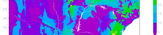
15 Number of cases with P> 100 mm/(2 days) for 16 gauging stations over central and northeastern Argentina / 62 63/ 66 67/ 70 71/ 74 75/ 78 79/ 82 83/ 86 87/ 90 91/ 94 95/ 98 99/ 02 AÑOS

16 La Plata river discharge
17 Scientific Motivations Climate Change Scenarios
18 LPB temperature and precipitation scenarios for Temperature Precipitation In the La Plata Basin, temperatures will be higher and rainfall will tend to be above normal as projected by all IPCC models, especially for the time slices between 2050 and Courtesy of Marengo

 areas")

19 RISK MAPS 2030 Return period RISK MAPS 2070 Return period Floods will be more frequent over larger (populated) areas near the mouth of the La Plata River Re, Luduena & Menendez
20 Implementation Plan GEF
21 Implementation Plan PART A: The International Program on the La Plata Basin (LPB) 1. La Plata Basin 2. Scientific background PART B: Current status of research and applications 3. Survey of observational datasets 4. Modeling capabilities PART C: Implementation of LPB CSE 5. Data rescue efforts 6. Hydro-climatic monitoring activities 7. Field Experiment (PLATEX) 8. Data management 9. Modeling activities 10. Predictability and climate change assessments 11. LPB Timeline ( ) 12. LPB Legacy
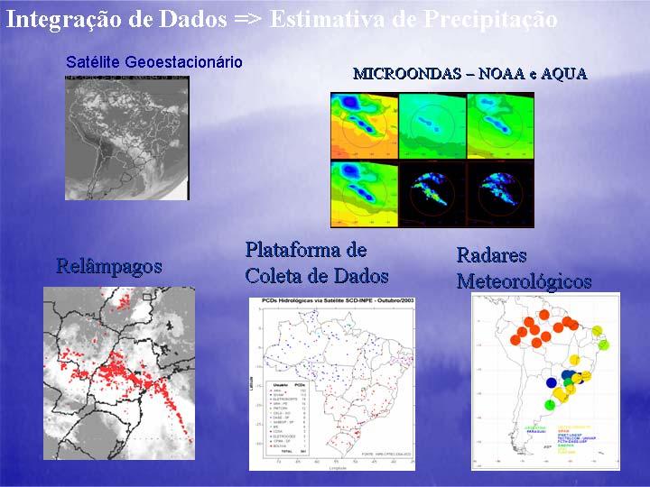
22 PART B: Current status of research and applications 3. Survey of observational datasets 3.1 Surface datasets 3.2 In-situ measurements 3.3 Hydrologic Observations 3.4 Remote sensing 3.5 Radars 3.6 Soil moisture measurements and estimates 3.7 Flux towers 4. Modeling capabilities 4.1 Atmospheric Models 4.2 Distributed Hydrological Models 4.3 Regional Institutions
23 PART C: Implementation of LPB CSE (1) 5. Data rescue efforts 6. Hydro-climatic monitoring activities 6.1 A supersite 6.2 Digital raingauges 6.3 In-situ soil moisture measurements 6.4 Flux Towers 6.5 Wind profiler 7. Field Experiment (PLATEX) 7.1 Doppler radar measurements 7.2 Aircraft soil moisture measurements 7.3 Flux towers 7.4 Upper air observations 7.5 Operations Center
24 PART C: Implementation of LPB CSE (2) 9. Modeling activities 9.1 Development of hydrologic distributed models 9.2 Coupled models development 9.3 Data Assimilation Effort 9.4 Ensemble forecasting 9.5 Coordination among forecasting institutions 10. Predictability and climate change assessments 10.1 Land cover/land use 10.2 Climate change scenarios and regional downscaling
25 Planned activities Land surface effects


26 Land cover / Land use

27

28 Vegetation types at 1 km resolution Eva et al (2004)
29 South American Land Data Assimilation System NASA/GSFC, CPTEC/INPE/Brazil and the University of Arizona are implementing SALDAS, using retrospectively and near real-time atmospheric forcing from numerical prediction models and remote sensing measurements. Model parameters will be derived from the existing high-resolution vegetation and soil types. Water and energy balances will be validated with various in-situ observations over South America The results, will be used to further validate and constrain the SALDAS predictions using data assimilation techniques and the land surface conditions used for NWP initialization. La Plata Basin: high spatial and temporal resolution runs help to improve the understanding of the hydrological and meteorological processes over the region. Under the LIS framework, SALDAS can be set to run at up to 1Km spatial resolution with hourly output.

30 UMD vegetation classification tropical rainforest broadleaf deciduous trees broadleaf and needleleaf trees needleleaf evergreen trees needleleaf deciduous trees broadleaf trees with ground cover grassland broadleaf shrubs with ground cover broadleaf shrubs with bare soil dwarf trees with ground cover desert crops


, 1697-1714")


31 South American Land Data Assimilation System Evaporation in Kg/m2 on December 1989 using ECMWF bias corrected atmospheric forcing (Berg et al., 2005, Int. J. Clim., 25 (13), ) Volumetric soil moisture on December 1989 using ECMWF bias corrected atmospheric forcing (Berg et al., 2005, Int. J. Clim., 25 (13), ) Volumetric soil moisture Total runoff (Kg/m 2 ) 1Km resolution - January 2000
32 Planned activities Hydrologic modeling


33 Cobertura e uso Solo + Blocos


34 Brazilian basins where a Distributed hydrologic model is being applied (UFRGS)


35 Model configuration
36 Uruguay Monthly time series of streamflow ( ) Uruguay at Paso de los Libres (Area: 189,300km 2 ) Streamflow (m 3 /s) Year Uruguay at Concordia (Area: 240,000km 2 ) Simulated Observed Streamflow (m 3 /s) Year Simulated Observed
37 Planned activities Datasets Remote sensing products

38

39
40 Planned activities Datasets Field experiment & Enhanced monitoring
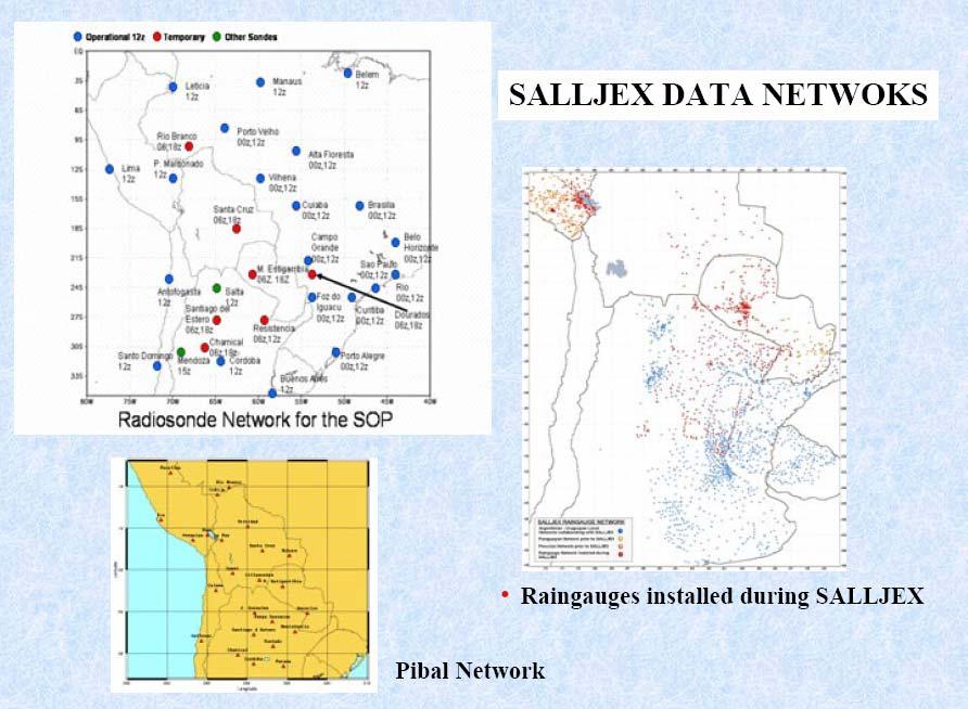
41 SALLJEX


42 VAMOS/SALLJEX NOAA/P-3 Missions


43 Flux towers in Pantanal and Parana State b a c d

 Agronomic")

44 Flux towers in Sao Paulo State Project funded by FAPESP (Dr. Humberto Rocha) Agronomic Institute of Campinas and UNICAMP experience on crop physiology will also be needed
 Air temperature profile (5 levels) H2O concentration profile (5")
 Incoming photosynthetically active radiation (PAR) Turbulence measurements above forest canopy High frequency (10.")
45 Micrometeorological observations in the Pantanal Area-Central Brazil Fazenda São Bento MS (19 o 33 S; 57 o 54 W) -Objectives: Meteorological campaigns in the Pantanal area during wet and dry season to study boundary layer process and influences on weather and climate in the region -Sensors at instrument tower (21 meters high) Air temperature profile (5 levels) H2O concentration profile (5 levels) op canopy temperature (Infra-red sensor) Wind velocity profile 5 levels) Wind direction Air pressure Precipitation Incoming and outgoing solar radiation (short wave radiation) Incoming and outgoing terrestrial radiation (long wave radiation) Incoming photosynthetically active radiation (PAR) Turbulence measurements above forest canopy High frequency (10.4 Hz) three wind components, air temperature, H2O and CO2 Concentration (Sensible and latent heat flux and CO2 flux) Soil measurements Soil heat flux (2 plates at depth of 1 cm and 10 cm, respectively) 2 five-level profiles of soil humidity, electric conductivity and temperature (sensors at depths of 1, 5, 10, 20, and 40 cm) Methane concentration -Additional instrumentation: Radiosonde station Tethered balloon Planned campaign in wet season of 2002

46

47
48 Working on establishing a supersite Raingauge Meso-network Soil moisture measurements Radar Flux Tower Aerosols Rawindsonde Wind profiler
 Pac) Climate change change scenarios Hydro-climate")
49 La Plata Basin Priority areas Land Land surface effects Extreme events Extreme events Variability and and trends trends SST SST Anomalies (Atl (Atl& Pac) Pac) Climate change change scenarios Hydro-climate Prediction
50 Main research areas Improvement of models representation of land surface-atmosphere interactions Land surface contributions to predictability Develop coupled models at adequate resolutions for hydrologic purposes Better estimates of MCS precipitation Climate change scenarios Impacts on the system s hydrology
51 LPB Timeline ( ) Build-up Phase Monitoring Field Experiment Model calibrations, parameterizations Predictability and Climate Change studies Development of an integrated system
52 Still working on: - Soil moisture measurements - Aerosols - Identification and establishment of a supersite - Dates for the field experiment - Data management and availability issues - A SAm regional reanalysis project - Field Experiment Manager - Links to water management A group meeting is needed to further advance our Implementation Plan: Can we do it by September 06?
Status on SALLJEX related investigations: Theme IV: Additional SALLJ related topics. J. A. Marengo CPTEC/INPE
 Status on SALLJEX related investigations: Theme IV: Additional SALLJ related topics J. A. Marengo CPTEC/INPE Summary -Use of SALLJEX data and others data sources (reanalyses, rainfall data sets, remote
South. America Level. Jet. field EXperiment
 South America Low Level Jet field EXperiment SALLJEX legacy and main findings Outline SALLJ Scientific Goals and Specific Objectives SALLJEX Components - Participant Countries SALLJEX observations and
SOUTH AMERICAN LOW-LEVEL JET EXPERIMENT. Data Workshop
 SOUTH AMERICAN LOW-LEVEL JET EXPERIMENT Data Workshop SALLJEX data Workshop Objectives To assess what progress have been made on SALLJEX objectives. To strength and arrange collaborations among the participants
Understanding and forecasting extreme weather events in Andes lee side: The Relampago opportunity
 Understanding and forecasting extreme weather events in Andes lee side: The Relampago opportunity Ariane Frassoni Center for Weather Forecasting and Climate Studies National Institute for Space Research
Seasonal Hydrological Forecasting in the Berg Water Management Area of South Africa
 Seasonal Hydrological Forecasting in the Berg Water Management Area of South Africa Trevor LUMSDEN and Roland SCHULZE University of KwaZulu-Natal, South Africa OUTLINE Introduction Objectives Study Area
CPTEC and NCEP Model Forecast Drift and South America during the Southern Hemisphere Summer
 CPTEC and NCEP Model Forecast Drift and South America during the Southern Hemisphere Summer José Antonio Aravéquia 1 Pedro L. Silva Dias 2 (1) Center for Weather Forecasting and Climate Research National
Land Data Assimilation at NCEP NLDAS Project Overview, ECMWF HEPEX 2004
 Dag.Lohmann@noaa.gov, Land Data Assimilation at NCEP NLDAS Project Overview, ECMWF HEPEX 2004 Land Data Assimilation at NCEP: Strategic Lessons Learned from the North American Land Data Assimilation System
Implementation of the NCEP operational GLDAS for the CFS land initialization
 Implementation of the NCEP operational GLDAS for the CFS land initialization Jesse Meng, Mickael Ek, Rongqian Yang NOAA/NCEP/EMC July 2012 1 Improving the Global Land Surface Climatology via improved Global
MESA Modeling and Data Assimilation. MESA modeling group: I. Cavalcanti, A. Seth, C. Saulo, B. Kirtman, V. Misra
 MESA Modeling and Data Assimilation MESA modeling group: I. Cavalcanti, A. Seth, C. Saulo, B. Kirtman, V. Misra MESA modeling objectives Model Assessment Model Development Hypothesis Testing RESULTS OF
VIC Hydrology Model Training Workshop Part II: Building a model
 VIC Hydrology Model Training Workshop Part II: Building a model 11-12 Oct 2011 Centro de Cambio Global Pontificia Universidad Católica de Chile Ed Maurer Civil Engineering Department Santa Clara University
Predictability in the Plata Basin: linkage to the THORPEX and GEWEX programs
 Predictability in the Plata Basin: linkage to the THORPEX and GEWEX programs Pedro L. Silva Dias Institute of Astronomy, Geophysics and Atmospheric Sciences University of São Paulo 1st LPB Implementation
Regional offline land surface simulations over eastern Canada using CLASS. Diana Verseghy Climate Research Division Environment Canada
 Regional offline land surface simulations over eastern Canada using CLASS Diana Verseghy Climate Research Division Environment Canada The Canadian Land Surface Scheme (CLASS) Originally developed for the
Diagnosing the Climatology and Interannual Variability of North American Summer Climate with the Regional Atmospheric Modeling System (RAMS)
") Diagnosing the Climatology and Interannual Variability of North American Summer Climate with the Regional Atmospheric Modeling System (RAMS) Christopher L. Castro and Roger A. Pielke, Sr. Department of
Diagnosing the Climatology and Interannual Variability of North American Summer Climate with the Regional Atmospheric Modeling System (RAMS) Christopher L. Castro and Roger A. Pielke, Sr. Department of
Soil Moisture Prediction and Assimilation
 Soil Moisture Prediction and Assimilation Analysis and Prediction in Agricultural Landscapes Saskatoon, June 19-20, 2007 STEPHANE BELAIR Meteorological Research Division Prediction and Assimilation Atmospheric
Drought Monitoring with Hydrological Modelling
 st Joint EARS/JRC International Drought Workshop, Ljubljana,.-5. September 009 Drought Monitoring with Hydrological Modelling Stefan Niemeyer IES - Institute for Environment and Sustainability Ispra -
The role of soil moisture in influencing climate and terrestrial ecosystem processes
 1of 18 The role of soil moisture in influencing climate and terrestrial ecosystem processes Vivek Arora Canadian Centre for Climate Modelling and Analysis Meteorological Service of Canada Outline 2of 18
MONSOON EXPERIMENT IN SOUTH AMERICA (MESA)
") MONSOON EXPERIMENT IN SOUTH AMERICA (MESA) An internationally coordinated, joint CLIVAR GEWEX program aimed at providing: 1.a better understanding of the South American monsoon system and its variability,
MONSOON EXPERIMENT IN SOUTH AMERICA (MESA) An internationally coordinated, joint CLIVAR GEWEX program aimed at providing: 1.a better understanding of the South American monsoon system and its variability,
Land Surface Processes and Their Impact in Weather Forecasting
 Land Surface Processes and Their Impact in Weather Forecasting Andrea Hahmann NCAR/RAL with thanks to P. Dirmeyer (COLA) and R. Koster (NASA/GSFC) Forecasters Conference Summer 2005 Andrea Hahmann ATEC
APPLICATION OF IMPROVED ECOSYSTEM AERODYNAMICS IN REGIONAL WEATHER FORECASTS
 Ecological Applications, 14(4) Supplement, 2004, pp. S17 S21 2004 by the Ecological Society of America APPLICATION OF IMPROVED ECOSYSTEM AERODYNAMICS IN REGIONAL WEATHER FORECASTS L. GUSTAVO GONCALVES
Influence of rainfall space-time variability over the Ouémé basin in Benin
 102 Remote Sensing and GIS for Hydrology and Water Resources (IAHS Publ. 368, 2015) (Proceedings RSHS14 and ICGRHWE14, Guangzhou, China, August 2014). Influence of rainfall space-time variability over
EVALUATION AND SENSITIVITY STUDIES OF SALLJ NUMERICAL SIMULATIONS
 EVALUATION AND SENSITIVITY STUDIES OF SALLJ NUMERICAL SIMULATIONS Analysis Impact Model Validation Forecast Impact EVALUATION AND SENSITIVITY STUDIES OF SALLJ NUMERICAL SIMULATIONS Analysis Impact (Demaria
Creating a WeatherSMART nation: SAWS drought related research, services and products
 Creating a WeatherSMART nation: SAWS drought related research, services and products Drought Dialogue 23-24 June 2016 Western Cape Government Hannes Rautenbach South African Weather Service SAWS mandate
Evaporative Fraction and Bulk Transfer Coefficients Estimate through Radiometric Surface Temperature Assimilation
 Evaporative Fraction and Bulk Transfer Coefficients Estimate through Radiometric Surface Temperature Assimilation Francesca Sini, Giorgio Boni CIMA Centro di ricerca Interuniversitario in Monitoraggio
Regional dry-season climate changes due to three decades of Amazonian deforestation
 In the format provided by the authors and unedited. SUPPLEMENTARY INFORMATION DOI:./NCLIMATE Regional dry-season climate changes due to three decades of Amazonian deforestation Jaya problemkhanna by using
Assimilation of satellite derived soil moisture for weather forecasting
 Assimilation of satellite derived soil moisture for weather forecasting www.cawcr.gov.au Imtiaz Dharssi and Peter Steinle February 2011 SMOS/SMAP workshop, Monash University Summary In preparation of the
STATISTICAL DOWNSCALING OF DAILY PRECIPITATION IN THE ARGENTINE PAMPAS REGION
 STATISTICAL DOWNSCALING OF DAILY PRECIPITATION IN THE ARGENTINE PAMPAS REGION Bettolli ML- Penalba OC Department of Atmospheric and Ocean Sciences, University of Buenos Aires, Argentina National Council
Wind Resource Analysis
 Wind Resource Analysis An Introductory Overview MGA/NWCC Midwestern Wind Energy: Moving It to Markets July 30, 2008 Detroit, Michigan Mark Ahlstrom 1 WindLogics Background Founded 1989 - supercomputing
Land Management and Natural Hazards Unit --- DESERT Action 1. Land Management and Natural Hazards Unit Institute for Environment and Sustainability
 Land Management and Natural Hazards Unit --- DESERT Action 1 Monitoring Drought with Meteorological and Remote Sensing Data A case study on the Horn of Africa Paulo Barbosa and Gustavo Naumann Land Management
Developing a High-Resolution Texas Water and Climate Prediction Model
 Developing a High-Resolution Texas Water and Climate Prediction Model Zong-Liang Yang (512) 471-3824 liang@jsg.utexas.edu Water Forum II on Texas Drought and Beyond, Austin, Texas, 22-23 October, 2012
5. General Circulation Models
 5. General Circulation Models I. 3-D Climate Models (General Circulation Models) To include the full three-dimensional aspect of climate, including the calculation of the dynamical transports, requires
Observed State of the Global Climate
 WMO Observed State of the Global Climate Jerry Lengoasa WMO June 2013 WMO Observations of Changes of the physical state of the climate ESSENTIAL CLIMATE VARIABLES OCEANIC ATMOSPHERIC TERRESTRIAL Surface
The National Operational Hydrologic Remote Sensing Center Operational Snow Analysis
 The National Operational Hydrologic Remote Sensing Center Operational Snow Analysis World Meteorological Organization Global Cryosphere Watch Snow-Watch Workshop Session 3: Snow Analysis Products Andrew
Adaptation for global application of calibration and downscaling methods of medium range ensemble weather forecasts
 Adaptation for global application of calibration and downscaling methods of medium range ensemble weather forecasts Nathalie Voisin Hydrology Group Seminar UW 11/18/2009 Objective Develop a medium range
CLIMATE CHANGE AND REGIONAL HYDROLOGY ACROSS THE NORTHEAST US: Evidence of Changes, Model Projections, and Remote Sensing Approaches
 CLIMATE CHANGE AND REGIONAL HYDROLOGY ACROSS THE NORTHEAST US: Evidence of Changes, Model Projections, and Remote Sensing Approaches Michael A. Rawlins Dept of Geosciences University of Massachusetts OUTLINE
Eric Mougin & Josiane Seghieri CESBIO. TT members : 20 european teams 6 malian institutions
 TT3 EOP integrative studies on the Gourma meso-scale site (Mali) Eric Mougin & Josiane Seghieri CESBIO TT members : 20 european teams 6 malian institutions The AMMA meso-scale sites Gourma Niamey Ouémé
The PRECIS Regional Climate Model
 The PRECIS Regional Climate Model General overview (1) The regional climate model (RCM) within PRECIS is a model of the atmosphere and land surface, of limited area and high resolution and locatable over
Understanding Weather and Climate Risk. Matthew Perry Sharing an Uncertain World Conference The Geological Society, 13 July 2017
 Understanding Weather and Climate Risk Matthew Perry Sharing an Uncertain World Conference The Geological Society, 13 July 2017 What is risk in a weather and climate context? Hazard: something with the
Climate Modeling Research & Applications in Wales. John Houghton. C 3 W conference, Aberystwyth
 Climate Modeling Research & Applications in Wales John Houghton C 3 W conference, Aberystwyth 26 April 2011 Computer Modeling of the Atmosphere & Climate System has revolutionized Weather Forecasting and
GRID RAINFALL DISAGGREGATION TOWARD A PATCH-BASED ENSEMBLE KALMAN FILTER FOR SOIL MOISTURE DATA ASSIMILATION
 GRID RAINFALL DISAGGREGATION TOWARD A PATCH-BASED ENSEMBLE KALMAN FILTER FOR SOIL MOISTURE DATA ASSIMILATION Filip Jagodzinski, Villanova University, Bryn Mawr, PA (filip.jagodzinski@villanova.edu) Mentor:
Meteorology. Chapter 15 Worksheet 1
 Chapter 15 Worksheet 1 Meteorology Name: Circle the letter that corresponds to the correct answer 1) The Tropic of Cancer and the Arctic Circle are examples of locations determined by: a) measuring systems.
Analysis of real-time prairie drought monitoring and forecasting system. Lei Wen and Charles A. Lin
 Analysis of real-time prairie drought monitoring and forecasting system Lei Wen and Charles A. Lin Back ground information A real-time drought monitoring and seasonal prediction system has been developed
Seasonal and interannual relations between precipitation, soil moisture and vegetation in the North American monsoon region
 Seasonal and interannual relations between precipitation, soil moisture and vegetation in the North American monsoon region Luis A. Mendez-Barroso 1, Enrique R. Vivoni 1, Christopher J. Watts 2 and Julio
APPLICATIONS OF DOWNSCALING: HYDROLOGY AND WATER RESOURCES EXAMPLES
 APPLICATIONS OF DOWNSCALING: HYDROLOGY AND WATER RESOURCES EXAMPLES Dennis P. Lettenmaier Department of Civil and Environmental Engineering For presentation at Workshop on Regional Climate Research NCAR
Flux Tower Data Quality Analysis in the North American Monsoon Region
 Flux Tower Data Quality Analysis in the North American Monsoon Region 1. Motivation The area of focus in this study is mainly Arizona, due to data richness and availability. Monsoon rains in Arizona usually
An overview of Seasonal Forecast-related related issues over the Pan-VAMOS domain
 An overview of Seasonal Forecast-related related issues over the Pan-VAMOS domain Celeste Saulo (U. of Buenos Aires- Argentina) Thanks to the contributions received from Matt Barlow, Hugo Berbery, Chris
Flood Forecasting in large basins
 Flood Forecasting in large basins Prof. Dr. Carlos E. M. Tucci IPH -Institute of Hydraulic Research UFRGS - Federal University of Rio Grande do Sul Contents Main Issues on Floods Flow forecast : basic
John R. Mecikalski #1, Martha C. Anderson*, Ryan D. Torn #, John M. Norman*, George R. Diak #
 P4.22 THE ATMOSPHERE-LAND EXCHANGE INVERSE (ALEXI) MODEL: REGIONAL- SCALE FLUX VALIDATIONS, CLIMATOLOGIES AND AVAILABLE SOIL WATER DERIVED FROM REMOTE SENSING INPUTS John R. Mecikalski #1, Martha C. Anderson*,
Surface Hydrology Research Group Università degli Studi di Cagliari
 Surface Hydrology Research Group Università degli Studi di Cagliari Evaluation of Input Uncertainty in Nested Flood Forecasts: Coupling a Multifractal Precipitation Downscaling Model and a Fully-Distributed
Developing Operational MME Forecasts for Subseasonal Timescales
 Developing Operational MME Forecasts for Subseasonal Timescales Dan C. Collins NOAA Climate Prediction Center (CPC) Acknowledgements: Stephen Baxter and Augustin Vintzileos (CPC and UMD) 1 Outline I. Operational
Terrestrial Snow Cover: Properties, Trends, and Feedbacks. Chris Derksen Climate Research Division, ECCC
 Terrestrial Snow Cover: Properties, Trends, and Feedbacks Chris Derksen Climate Research Division, ECCC Outline Three Snow Lectures: 1. Why you should care about snow: Snow and the cryosphere Classes of
Teleconnections and Climate predictability
 Southern Hemisphere Teleconnections and Climate predictability Carolina Vera CIMA/CONICET University of Buenos Aires, UMI IFAECI/CNRS Buenos Aires, Argentina Motivation Large scale circulation variability
Regional Flash Flood Guidance and Early Warning System
 WMO Training for Trainers Workshop on Integrated approach to flash flood and flood risk management 24-28 October 2010 Kathmandu, Nepal Regional Flash Flood Guidance and Early Warning System Dr. W. E. Grabs
Predicting ectotherm disease vector spread. - Benefits from multi-disciplinary approaches and directions forward
 Predicting ectotherm disease vector spread - Benefits from multi-disciplinary approaches and directions forward Naturwissenschaften Stephanie Margarete THOMAS, Carl BEIERKUHNLEIN, Department of Biogeography,
Tropical Montane Cloud Forests: Importance and Challenges in a Changing Environment
 Tropical Montane Cloud Forests: Importance and Challenges in a Changing Environment Daniel E. Comarazamy and Jorge E. González The NOAA-CREST Center & Department of Mechanical Engineering, City College
RETRIEVAL OF SOIL MOISTURE OVER SOUTH AMERICA DERIVED FROM MICROWAVE OBSERVATIONS
 2nd Workshop on Remote Sensing and Modeling of Surface Properties 9-11 June 2009, Toulouse, France Météo France Centre International de Conférences RETRIEVAL OF SOIL MOISTURE OVER SOUTH AMERICA DERIVED
Hands On Applications of the Latin American and Caribbean Flood and Drought Monitor (LACFDM)
") Hands On Applications of the Latin American and Caribbean Flood and Drought Monitor (LACFDM) Colby Fisher, Eric F Wood, Justin Sheffield, Nate Chaney Princeton University International Training: Application
Hands On Applications of the Latin American and Caribbean Flood and Drought Monitor (LACFDM) Colby Fisher, Eric F Wood, Justin Sheffield, Nate Chaney Princeton University International Training: Application
Seasonal forecasting of climate anomalies for agriculture in Italy: the TEMPIO Project
 Seasonal forecasting of climate anomalies for agriculture in Italy: the TEMPIO Project M. Baldi(*), S. Esposito(**), E. Di Giuseppe (**), M. Pasqui(*), G. Maracchi(*) and D. Vento (**) * CNR IBIMET **
4.5 Comparison of weather data from the Remote Automated Weather Station network and the North American Regional Reanalysis
 4.5 Comparison of weather data from the Remote Automated Weather Station network and the North American Regional Reanalysis Beth L. Hall and Timothy. J. Brown DRI, Reno, NV ABSTRACT. The North American
Mesoscale meteorological models. Claire L. Vincent, Caroline Draxl and Joakim R. Nielsen
 Mesoscale meteorological models Claire L. Vincent, Caroline Draxl and Joakim R. Nielsen Outline Mesoscale and synoptic scale meteorology Meteorological models Dynamics Parametrizations and interactions
Interaction of North American Land Data Assimilation System and National Soil Moisture Network: Soil Products and Beyond
 Interaction of North American Land Data Assimilation System and National Soil Moisture Network: Soil Products and Beyond Youlong Xia 1,2, Michael B. Ek 1, Yihua Wu 1,2, Christa Peters-Lidard 3, David M.
Climate Dynamics (PCC 587): Hydrologic Cycle and Global Warming
: Hydrologic Cycle and Global Warming") Climate Dynamics (PCC 587): Hydrologic Cycle and Global Warming D A R G A N M. W. F R I E R S O N U N I V E R S I T Y O F W A S H I N G T O N, D E P A R T M E N T O F A T M O S P H E R I C S C I E N C
Climate Dynamics (PCC 587): Hydrologic Cycle and Global Warming D A R G A N M. W. F R I E R S O N U N I V E R S I T Y O F W A S H I N G T O N, D E P A R T M E N T O F A T M O S P H E R I C S C I E N C
Toward a South America Land Data Assimilation System: Aspects of land surface model spin-up using the Simplified Simple Biosphere
 JOURNAL OF GEOPHYSICAL RESEARCH, VOL. 111,, doi:10.1029/2005jd006297, 2006 Toward a South America Land Data Assimilation System: Aspects of land surface model spin-up using the Simplified Simple Biosphere
SMAP and SMOS Integrated Soil Moisture Validation. T. J. Jackson USDA ARS
 SMAP and SMOS Integrated Soil Moisture Validation T. J. Jackson USDA ARS Perspective Linkage of SMOS and SMAP soil moisture calibration and validation will have short and long term benefits for both missions.
Flood Forecasting Tools for Ungauged Streams in Alberta: Status and Lessons from the Flood of 2013
 Flood Forecasting Tools for Ungauged Streams in Alberta: Status and Lessons from the Flood of 2013 John Pomeroy, Xing Fang, Kevin Shook, Tom Brown Centre for Hydrology, University of Saskatchewan, Saskatoon
Which Climate Model is Best?
 Which Climate Model is Best? Ben Santer Program for Climate Model Diagnosis and Intercomparison Lawrence Livermore National Laboratory, Livermore, CA 94550 Adapting for an Uncertain Climate: Preparing
Assimilating terrestrial remote sensing data into carbon models: Some issues
 University of Oklahoma Oct. 22-24, 2007 Assimilating terrestrial remote sensing data into carbon models: Some issues Shunlin Liang Department of Geography University of Maryland at College Park, USA Sliang@geog.umd.edu,
Abebe Sine Gebregiorgis, PhD Postdoc researcher. University of Oklahoma School of Civil Engineering and Environmental Science
 Abebe Sine Gebregiorgis, PhD Postdoc researcher University of Oklahoma School of Civil Engineering and Environmental Science November, 2014 MAKING SATELLITE PRECIPITATION PRODUCTS WORK FOR HYDROLOGIC APPLICATION
Robert Shedd Northeast River Forecast Center National Weather Service Taunton, Massachusetts, USA
 Robert Shedd Northeast River Forecast Center National Weather Service Taunton, Massachusetts, USA Outline River Forecast Centers FEWS Implementation Status Forcing Data Ensemble Forecasting The Northeast
Our climate system is based on the location of hot and cold air mass regions and the atmospheric circulation created by trade winds and westerlies.
 CLIMATE REGIONS Have you ever wondered why one area of the world is a desert, another a grassland, and another a rainforest? Or have you wondered why are there different types of forests and deserts with
Steady Flow: rad conv. where. E c T gz L q 2. p v 2 V. Integrate from surface to top of atmosphere: rad TOA rad conv surface
 The Three-Dimensional Circulation 1 Steady Flow: F k ˆ F k ˆ VE 0, rad conv where 1 E c T gz L q 2 p v 2 V Integrate from surface to top of atmosphere: VE F FF F 0 rad TOA rad conv surface 2 What causes
Anticipated and Observed Trends in the Global Hydrological Cycle. Kevin E. Trenberth NCAR
 Anticipated and Observed Trends in the Global Hydrological Cycle Kevin E. Trenberth NCAR The presence of moisture affects the disposition of incoming solar radiation: Evaporation (drying) versus temperature
THE RAINWATER HARVESTING SYMPOSIUM 2015
 THE RAINWATER HARVESTING SYMPOSIUM 2015 Remote Sensing for Rainwater Harvesting and Recharge Estimation under Data Scarce Conditions Taye Alemayehu Ethiopian Institute of Water Resources, Metameta Research
Inter-linkage case study in Pakistan
 7 th GEOSS Asia Pacific Symposium GEOSS AWCI Parallel Session: 26-28 May, 2014, Tokyo, Japan Inter-linkage case study in Pakistan Snow and glaciermelt runoff modeling in Upper Indus Basin of Pakistan Maheswor
Climate Change and Runoff Statistics in the Rhine Basin: A Process Study with a Coupled Climate-Runoff Model
 IACETH Climate Change and Runoff Statistics in the Rhine Basin: A Process Study with a Coupled Climate-Runoff Model Jan KLEINN, Christoph Frei, Joachim Gurtz, Pier Luigi Vidale, and Christoph Schär Institute
Impact of vegetation cover estimates on regional climate forecasts
 Impact of vegetation cover estimates on regional climate forecasts Phillip Stauffer*, William Capehart*, Christopher Wright**, Geoffery Henebry** *Institute of Atmospheric Sciences, South Dakota School
A Facility for Producing Consistent Remotely Sensed Biophysical Data Products of Australia
 TERRESTRIAL ECOSYSTEM RESEARCH NETWORK - AusCover - A Facility for Producing Consistent Remotely Sensed Biophysical Data Products of Australia June, 2011 Mervyn Lynch Professor of Remote Sensing Curtin
Arizona Drought Monitoring Sensitivity and Verification Analyses Project Results and Future Directions
 Arizona Drought Monitoring Sensitivity and Verification Analyses Project Results and Future Directions A Water Sustainability Institute, Technology and Research Initiative Fund Project Christopher L. Castro,
IMPACT OF CLIMATE CHANGE OVER THE ARABIAN PENINSULA
 IMPACT OF CLIMATE CHANGE OVER THE ARABIAN PENINSULA By: Talal Alharbi June, 29 2017 1 Motivation: In arid and semi-arid regions of the world the demand for fresh water resources is increasing due to: increasing
COUPLING A DISTRIBUTED HYDROLOGICAL MODEL TO REGIONAL CLIMATE MODEL OUTPUT: AN EVALUATION OF EXPERIMENTS FOR THE RHINE BASIN IN EUROPE
 P.1 COUPLING A DISTRIBUTED HYDROLOGICAL MODEL TO REGIONAL CLIMATE MODEL OUTPUT: AN EVALUATION OF EXPERIMENTS FOR THE RHINE BASIN IN EUROPE Jan Kleinn*, Christoph Frei, Joachim Gurtz, Pier Luigi Vidale,
IMPORTANCE OF SATELLITE DATA (FOR REANALYSIS AND BEYOND) Jörg Schulz EUMETSAT
 Jörg Schulz EUMETSAT") IMPORTANCE OF SATELLITE DATA (FOR REANALYSIS AND BEYOND) Jörg Schulz EUMETSAT Why satellite data for climate monitoring? Global coverage Global consistency, sometimes also temporal consistency High spatial
IMPORTANCE OF SATELLITE DATA (FOR REANALYSIS AND BEYOND) Jörg Schulz EUMETSAT Why satellite data for climate monitoring? Global coverage Global consistency, sometimes also temporal consistency High spatial
2009 Progress Report To The National Aeronautics and Space Administration NASA Energy and Water Cycle Study (NEWS) Program
 Program") 2009 Progress Report To The National Aeronautics and Space Administration NASA Energy and Water Cycle Study (NEWS) Program Proposal Title: Grant Number: PI: The Challenges of Utilizing Satellite Precipitation
2009 Progress Report To The National Aeronautics and Space Administration NASA Energy and Water Cycle Study (NEWS) Program Proposal Title: Grant Number: PI: The Challenges of Utilizing Satellite Precipitation
ATMOSPHERIC MODEL. Iracema Fonseca Albuquerque Cavalcanti
 ATMOSPHERIC MODEL Iracema Fonseca Albuquerque Cavalcanti José Paulo Bonatti CPTEC/INPE Silvio Nilo Figueroa- CPTEC/INPE Paulo Kubota CPTEC/INPE Henrique M.J. Barbosa- USP Solange Souza-CPTEC/INPE Christopher
Development of the Canadian Precipitation Analysis (CaPA) and the Canadian Land Data Assimilation System (CaLDAS)
 and the Canadian Land Data Assimilation System (CaLDAS)") Development of the Canadian Precipitation Analysis (CaPA) and the Canadian Land Data Assimilation System (CaLDAS) Marco L. Carrera, Vincent Fortin and Stéphane Bélair Meteorological Research Division Environment
Development of the Canadian Precipitation Analysis (CaPA) and the Canadian Land Data Assimilation System (CaLDAS) Marco L. Carrera, Vincent Fortin and Stéphane Bélair Meteorological Research Division Environment
Re-analysis activities at SMHI
 Re-analysis activities at SMHI by: Anna Jansson and Per Kållberg Contents Variational data assimilation at SMHI Operational MESAN Applications of MESAN MESAN used for a long time period Variational data
CGMS Baseline. Sustained contributions to the Global Observing System. Endorsed by CGMS-46 in Bengaluru, June 2018
 CGMS Baseline Sustained contributions to the Global Observing System Best Practices for Achieving User Readiness for New Meteorological Satellites Endorsed by CGMS-46 in Bengaluru, June 2018 CGMS/DOC/18/1028862,
The Idea behind DEMETER
 Development of a European Multi-Model Ensemble System for Seasonal to Interannual Prediction Tim Palmer Renate Hagedorn Francisco Doblas-Reyes The Idea behind DEMETER Demand for reliable seasonal forecasts
Arizona Drought Monitoring Sensitivity and Verification Analyses
 Arizona Drought Monitoring Sensitivity and Verification Analyses A Water Sustainability Institute, Technology and Research Initiative Fund Project Christopher L. Castro, Francina Dominguez, Stephen Bieda
A SATELLITE LAND DATA ASSIMILATION SYTEM COUPLED WITH A MESOSCALE MODEL: TOWARDS IMPROVING NUMERICAL WEATHER PREDICTION
 A SATELLITE LAND DATA ASSIMILATION SYTEM COUPLED WITH A MESOSCALE MODEL: TOWARDS IMPROVING NUMERICAL WEATHER PREDICTION Mohamed Rasmy*, Toshio Koike*, Souhail Bousseta**, Xin Li*** Dept. of Civil Engineering,
Energy Systems, Structures and Processes Essential Standard: Analyze patterns of global climate change over time Learning Objective: Differentiate
 Energy Systems, Structures and Processes Essential Standard: Analyze patterns of global climate change over time Learning Objective: Differentiate between weather and climate Global Climate Focus Question
FFGS Advances. Initial planning meeting, Nay Pyi Taw, Myanmar February, Eylon Shamir, Ph.D,
 FFGS Advances Initial planning meeting, Nay Pyi Taw, Myanmar 26-28 February, 2018 Eylon Shamir, Ph.D, EShamir@hrcwater.org Hydrologic Research Center San Diego, California FFG System Enhancements The following
Water Balance in the Murray-Darling Basin and the recent drought as modelled with WRF
 18 th World IMACS / MODSIM Congress, Cairns, Australia 13-17 July 2009 http://mssanz.org.au/modsim09 Water Balance in the Murray-Darling Basin and the recent drought as modelled with WRF Evans, J.P. Climate
Agrometeorological activities in RHMSS
 Republic of Serbia Republic Hydrometeorological Service of Serbia Agrometeorological activities in RHMSS Department for applied climatology and agrometeorology www.hidmet.gov.rs Meteorological Observing
An Integrated Approach to the Prediction of Weather, Renewable Energy Generation and Energy Demand in Vermont
 1 An Integrated Approach to the Prediction of Weather, Renewable Energy Generation and Energy Demand in Vermont James P. Cipriani IBM Thomas J. Watson Research Center Yorktown Heights, NY Other contributors
METRIC tm. Mapping Evapotranspiration at high Resolution with Internalized Calibration. Shifa Dinesh
 METRIC tm Mapping Evapotranspiration at high Resolution with Internalized Calibration Shifa Dinesh Outline Introduction Background of METRIC tm Surface Energy Balance Image Processing Estimation of Energy
Canadian Prairie Snow Cover Variability
 Canadian Prairie Snow Cover Variability Chris Derksen, Ross Brown, Murray MacKay, Anne Walker Climate Research Division Environment Canada Ongoing Activities: Snow Cover Variability and Links to Atmospheric
REVISION OF THE STATEMENT OF GUIDANCE FOR GLOBAL NUMERICAL WEATHER PREDICTION. (Submitted by Dr. J. Eyre)
") WORLD METEOROLOGICAL ORGANIZATION Distr.: RESTRICTED CBS/OPAG-IOS (ODRRGOS-5)/Doc.5, Add.5 (11.VI.2002) COMMISSION FOR BASIC SYSTEMS OPEN PROGRAMME AREA GROUP ON INTEGRATED OBSERVING SYSTEMS ITEM: 4 EXPERT
WORLD METEOROLOGICAL ORGANIZATION Distr.: RESTRICTED CBS/OPAG-IOS (ODRRGOS-5)/Doc.5, Add.5 (11.VI.2002) COMMISSION FOR BASIC SYSTEMS OPEN PROGRAMME AREA GROUP ON INTEGRATED OBSERVING SYSTEMS ITEM: 4 EXPERT
Evaluation of remotely sensed and modelled soil moisture products using global ground-based in situ observations
 Evaluation of remotely sensed and modelled soil moisture products using global ground-based in situ observations C. Albergel (1), P. de Rosnay (1), G. Balsamo (1),J. Muñoz-Sabater(1 ), C. Gruhier (2),
Climate Modeling and Downscaling
 Climate Modeling and Downscaling Types of climate-change experiments: a preview 1) What-if sensitivity experiments increase the optically active gases and aerosols according to an assumed scenario, and
Experiences of using ECV datasets in ECMWF reanalyses including CCI applications. David Tan and colleagues ECMWF, Reading, UK
 Experiences of using ECV datasets in ECMWF reanalyses including CCI applications David Tan and colleagues ECMWF, Reading, UK Slide 1 Main points Experience shows benefit of integrated & iterative approach
First steps toward a comparison of modelled thermal comfort during a heatwave in Melbourne, Australia
 First steps toward a comparison of modelled thermal comfort during a heatwave in Melbourne, Australia Stephanie Jacobs PhD supervisors: Ailie Gallant and Nigel Tapper Outline of talk Motivation for research