In-flight Spectral Calibration of MERIS/OLCI. Jürgen Fischer, Rene Preusker, Rasmus Lindstrot Institute for Space Science Free University Berlin
|
|
|
- Cuthbert Fitzgerald
- 5 years ago
- Views:
Transcription
1 In-flight Spectral Calibration of MERIS/OLCI Jürgen Fischer, Rene Preusker, Rasmus Lindstrot Institute for Space Science Free University Berlin 1

2 MERIS Instrument 2

3 MERIS Instrument Concept 3

4 MERIS Operation Bourg & Delwart,
5 MERIS Calibration (Bourg &Delwart, 2011) Radiometric Calibration, executed every two weeks, starts with a Dark Calibration (shutter) followed by Radiometric Calibration with the frequently illuminated diffuser centered when the solar illumination angle on the diffuser is at Diffuser Aging Calibration sequence, is executed every three months. Spectral Calibration, executed every three months, is performed on two consecutive orbits with the instrument spectral band setting (with =1.25 nm) centered around Erbium spectral features at 410 nm and 520 nm. 5
6 MERIS Calibration Process (Bourg &Delwart, 2011) 1. Radiometric calibration measurement provides instrument numerical counts X cal (,k), where stands for the spectral channel and k for the spatial position. 2. Instrumental corrections (non-linearity, dark offset, smear) yields corrected counts, X cal (,k), considered as perfectly proportional to the radiance at instrument entrance, including the straylight contribution. 3. Instrument Inverse Gain Coefficients A 0 are then computed such as X cal (b,k,m) = A 0 (b,k,m) * L cal (b,k,m) where X cal (b,k,m,t) = N L -1 (X cal (b,k,m,t) C 0 b,k,m Sm(b,k,m,t) are the calibration counts corrected for non-linearity, dark offset and smear. 6
7 MERIS Calibration Process (Bourg &Delwart, 2011) 4. L cal is estimated from E 0 (), the Sun extraterrestrial irradiance at the MERIS channel wavelength, illumination and viewing geometry and the diffuser BRDF. Straylight contribution is computed and added to the calibration radiance before use. This process includes an iterative loop: as the straylight contribution is estimated from the corrupted signal, the corrected signal allows deriving a better estimate of the straylight contribution that in turn allows computing a better corrected signal. 5. The diffuser BRDF has been characterised on-ground and is corrected for the diffuser ageing when used on on-orbit data. 6. E 0 is derived from a model, the seasonal variation of the Sun-Earth distance, and the instrument spectral characterization (channels central wavelengths and spectral response curves); 7. Geometry is derived from satellite position and attitude computations and instrument pointing characterisation. 7
8 MERIS response functions Modeled band 11 Line shape (3 spectral pixels) (left) and band 15 line shape (16 spectral pixels) for the central pixel of the five cameras. 8


9 MERIS Straylight Straylight convolution kernel in log scale (generated for FM1 or camera 4 at 715 nm and FOV centre) 9
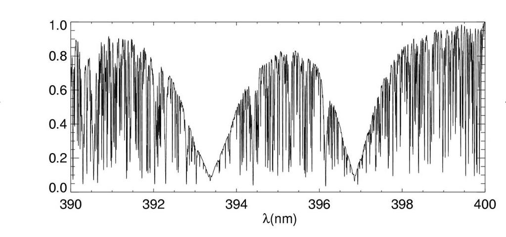
10 BASIS of Spectral Calibration Spectral Calibration of MERIS uses the ability to program the 15 channels around spectral features such as 1. Erbium doped Spectralon diffuser absorption spectrum 2. Fraunhofer lines 3. atmospheric absorption bands (O2A). The micro-bands have a bandwidth of 1.7nm (fwhm) and a sampling of 1.25nm 10
11 Erbium doped Spectralon diffuser absorption spectrum 11
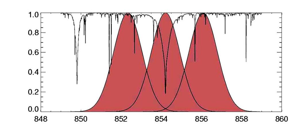
12 Fraunhofer method Prerequisites: - The spectral channels of MERIS are placed around the Fraunhofer lines - A database of simulated MERIS measurements in the range of the Fraunhofer lines. Spectral calibration by finding the best LUT entry 12
13 Method 13
14 Theoretical accuracy for 4 micro-channels around the Fraunhofer lines: 396 nm 589 nm 854 nm 486 nm 656 nm 866 nm 14
15 Theoretical accuracy for 6 micro-channels around the Fraunhofer lines : 396 nm 589 nm 854 nm 486 nm 656 nm 866 nm 15
16 MERIS RADIOMETRIC CALIBRATION PRINCIPLE Characterised central wavelength for Camera 4. Left: Wavelengths (nm) as a function of CCD line number; right: Deviation from linear trend [nm] as a function of line number. (Line 1 = 390nm, Line 520 = 1040 nm) 16
17 O2A Method Prerequisite: The measured shape S of the oxygen A band is a function of spectral position of the channels and almost independent on surface and atmospheric conditions. S i 1n I( i ) ln( I 1n( I ) 1n( I min 0 0 ) ) 1 k k eff eff ( ) ( i min ) Usage of a compressed LUT (NN) of simulated O2A measurements for a huge variety of surface and atmospheric conditions. 17
18 Example: P_surf=980 hpa tau_aer=0.05 alb=0.05 P_surf=1030 hpa tau_aer=0.35 alb=0.8 Simulated radiance for the sub-channels for different situations: absolute values differ, shape is constant for the same spectral position 18
19 Spectral calibration Characterised central wavelength for all MERIS cameras as a function of field of view (column #) for line 297 centred at 760 nm (Bourg and Delwart, 2011) 19
20 Consistency of Fraunhofer and oxygen calibration For almost all cases the oxygen calibration results had an offset between 0.05 and 0.15nm! Module 4 Module 5 20
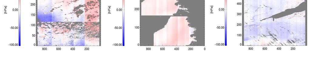
21 Empirical correction of straylight Problem - Prominent camera boundaries - Pressure jumps at boundaries depend on brightness and height (pressure) of the scene Strategy - Stray light model - Spectral model Tools - Surface pressure ANN: SP FUB - Cloud-top pressure ANN: CTP FUB - Reference data: - SP: Digital elevation models: GTOPO, GLAS/ IceSAT + ECMWF - CTP: MSG brightness temperature Data - MERIS Scenes Results 21
22 Idea Optimize coefficients of simple stray-light model by fitting SPand CTP-retrieval to accurate reference data. First approach: - As spectral misalignment (smile) and stray-light cause highly correlated errors, both were adjusted simultaneously. - Results are purely artificial. Second approach: - We assume that spectral Fraunhofer calibration is accurate within ±0.1nm. - Limit spectral adjustment, optimize stray light coefficients - More physical results. 22
23 Stray light model Assumptions: Stray-light is proportional to brightness in window channel: s = f * rad10 Quartic dependence of f on detector index x: f = a + bx + cx 4 rad11_corr = rad11 + f * rad10 23
24 Spectral model Assumptions: Spectral Fraunhofer calibration is valid in the O 2 A band. Difference of spectral misalignment from Fraunhofer calibration is constant for each camera: = d In the optimization d was restricted to ±0.1nm (Fraunhofer calibration accuracy) 24
25 Sensitivity of channel ratio to temperature profile Impact of temperature profile (relative to US standard atmosphere) on channel ratio r (middle) and retrieved surface pressure (right), depending on surface elevation. 25


26 Used data - desert 4 desert scenes: , orbit 18598, Libyan desert , orbit 18755, Egypt desert , orbit 18897, Iran / Pakistan , orbit 18926, Iran 26


27 Used data - Greenland 3 Greenland scenes: , orbit , orbit , orbit


28 Used data - Clouds 3 cloud scenes: , orbit 16394, Benguela current , orbit 18899, Benguela current , orbit 18956, Benguela current 28

29 Results 29
30 Results Black: Reference pressure Red: Corrected pressure Blue: Uncorrected pressure 30
31 Surface pressure SP FUB / stray-light factor Resulting stray light factor f: Center wavelength band 11 (black: Fraunhofer calib, red: optimized) 31
32 Summary: Both algorithms are working Individual accuracy is better than 0.1nm Inconsistency between Fraunhofer data based spectral model and O2A method still not solved. Has to be examined in more detail! Candidates for failure: 1.Pressure and temperature dependence of O2A absorption lines 2.Spectroscopy of the O2A band 3.Insufficient stray-light model 32

33 OLCI (Ocean & Land Color Instrument) OLCI: -Swath 1300km -21 channels [ μm] - Wider spectral range Additional use of H 2 0 -aborption band Identification of optimal channels is needed ESA 33
")

34 OLCI (Ocean & Land Color Instrument) Additional use of Ca Fraunhofer-line ESA 34
35 Recommendation for OLCI spectral calibration Spectral calibration - Use additional Fraunhofer Ca-line ( =1005 nm) - Use of H 2 0 -aborption lines between 920 nm and 970 nm - Analyse camera boundaries Spectral correction factor / stray-light correction - Derive via surface pressure and digital height model - Use 3 O 2 A-band channels - Perform bias-monitoring Rayleigh correction above dark ocean surfaces - Use improved radiative transfer in ocean and atmosphere (polarisation) - Use of complex refractive index as function of wavelength, temperature and salinity 35
36 Multi-satellite observations Filling the ENVISAT Sentinel-3 gap and extending the global water vapour data set BIAS (TCWV) MODIS MERIS? OLCI


37 MODIS scanning scheme 10 detectors for each channel (1km resolution) 37
38 MODIS channel characterisation - TERRA 38
39 Terra MODIS Spectral - C Shift (Salomonson et al, 2004) 39
MERIS US Workshop. Instrument Characterization Overview. Steven Delwart
 MERIS US Workshop Instrument Characterization Overview Steven Delwart Presentation Overview On-Ground Characterisation 1. Diffuser characterisation 2. Polarization sensitivity 3. Optical Transmission 4.
Calibration of MERIS on ENVISAT Status at End of 2002
 Calibration of MERIS on ENVISAT Status at End of 2002 Bourg L. a, Delwart S. b, Huot J-P. b a ACRI-ST, 260 route du Pin Montard, BP 234, 06904 Sophia-Antipolis Cedex, France b ESA/ESTEC, P.O. Box 299,
MERIS SMILE EFFECT CHARACTERISATION AND CORRECTION DOCUMENT. document title/ titre du document. prepared by/préparé par MERIS ESL
 DOCUMENT document title/ titre du document MERIS SMILE EFFECT CHARACTERISATION AND CORRECTION prepared by/préparé par MERIS ESL reference/réference issue/édition 2 revision/révision 0 date of issue/date
MERIS SURFACE PRESSURE AND CLOUD FLAG: PRESENT STATUS AND IMPROVEMENTS
 ABSTRACT MERIS SURFACE PRESSURE AND CLOUD FLAG: PRESENT STATUS AND IMPROVEMENTS D. Ramon (1), R. Santer (2), P. Dubuisson (2) (1) HYGEOS, 191 rue N. Appert, 59650 Villeneuve d Ascq, FRANCE, dr@hygeos.com
MERIS INSTRUMENT CALIBRATION INTRODUCTION
 MERIS INSTRUMENT CALIBRATION Ludovic Bourg (1), Steven Delwart (2) (1) ACRI-ST, 260 route du Pin Montard, BP 234, 06904 Sophia-Antipolis Cedex, France, e-mail: ludovic.boug@acri-st.fr (2) ESA/ESRIN, Via
Cloud screening and snow detection with MERIS. Rene Preusker, Jürgen Fischer, Carsten Brockmann, Marco Zühlke, Uwe krämer, Anja Hünerbein
 Cloud screening and snow detection with MERIS Rene Preusker, Jürgen Fischer, Carsten Brockmann, Marco Zühlke, Uwe krämer, Anja Hünerbein Prelude The following algorithm has been compiled in the frame of
Long-Term Time Series of Water Vapour Total Columns from GOME, SCIAMACHY and GOME-2
 Graphics: ESA Graphics: ESA Graphics: ESA Long-Term Time Series of Water Vapour Total Columns from GOME, SCIAMACHY and GOME-2 S. Noël, S. Mieruch, H. Bovensmann, J. P. Burrows Institute of Environmental
VERIFICATION OF MERIS LEVEL 2 PRODUCTS: CLOUD TOP PRESSURE AND CLOUD OPTICAL THICKNESS
 VERIFICATION OF MERIS LEVEL 2 PRODUCTS: CLOUD TOP PRESSURE AND CLOUD OPTICAL THICKNESS Rene Preusker, Peter Albert and Juergen Fischer 17th December 2002 Freie Universitaet Berlin Institut fuer Weltraumwissenschaften
In-flight Calibration Techniques Using Natural Targets. CNES Activities on Calibration of Space Sensors
 In-flight Calibration Techniques Using Natural Targets CNES Activities on Calibration of Space Sensors Bertrand Fougnie, Patrice Henry (DCT/SI, CNES, Toulouse, France) In-flight Calibration using Natural
Ocean Colour: Calibration Approach. CEOS WGCV-39, May The International Ocean Colour Coordinating Group
 Ocean Colour: Calibration Approach CEOS WGCV-39, May 2015 The International Ocean Colour Coordinating Group Ocean Colour requires special calibration considerations Percentage of ocean signal in the total
Overview of Hyperion On-Orbit Instrument Performance, Stability, and Artifacts
 Overview of Hyperion On-Orbit Instrument Performance, Stability, and Artifacts EO-1 Science Validation Team Meeting November 21, 2002 Debbie Beiso TRW Space and Electronics Redondo Beach, CA San Francisco
Sumi-NPP OMPS Calibration and Characterization from Early Orbit Images
 Sumi-NPP OMPS Calibration and Characterization from Early Orbit Images *C. Pan 1, F. Weng 2, X. Wu 2, L. Flynn 2, G. Jaross 3 and S. Janz 4 * 1 ESSIC, University of Maryland, College Park, MD 20740 2 NOAA
Chapter 4 Nadir looking UV measurement. Part-I: Theory and algorithm
 Chapter 4 Nadir looking UV measurement. Part-I: Theory and algorithm -Aerosol and tropospheric ozone retrieval method using continuous UV spectra- Atmospheric composition measurements from satellites are
(A)ATSR and SLSTR VIS/SWIR Channels Calibration
ATSR and SLSTR VIS/SWIR Channels Calibration") (A)ATSR and SLSTR VIS/SWIR Channels Calibration Dave Smith & Mireya Etxaluze 2017 RAL Space 1 ATSR Series 1991-2000 ATSR-1 1995-2008 ATSR-2 2002-2012- AATSR 2 SLSTR Series 2016 Sentinel 3A 2018 Sentinel
(A)ATSR and SLSTR VIS/SWIR Channels Calibration Dave Smith & Mireya Etxaluze 2017 RAL Space 1 ATSR Series 1991-2000 ATSR-1 1995-2008 ATSR-2 2002-2012- AATSR 2 SLSTR Series 2016 Sentinel 3A 2018 Sentinel
Sentinel-3 Sea and Land Surface Temperature Radiometer (SLSTR) Mireya Etxaluze (STFC RAL Space)
 Mireya Etxaluze (STFC RAL Space)") Sentinel-3 Sea and Land Surface Temperature Radiometer (SLSTR) Mireya Etxaluze (STFC RAL Space) RAL Space Radiometry Group Dave Smith Mireya Etxaluze, Ed Polehampton, Caroline Cox, Tim Nightingale, Dan
Sentinel-3 Sea and Land Surface Temperature Radiometer (SLSTR) Mireya Etxaluze (STFC RAL Space) RAL Space Radiometry Group Dave Smith Mireya Etxaluze, Ed Polehampton, Caroline Cox, Tim Nightingale, Dan
General Aspects I: What is a cloud?
 Cloud Detection General Aspects I: What is a cloud? I can tell you, if I see... A visible aggregate of minute water droplets and/or ice particles in the atmosphere above the earth s surface Global total
S3-A OLCI Cyclic Performance Report. Cycle No Start date: 27/10/2017. End date: 23/11/2017
 PREPARATION AND OPERATIONS OF THE MISSION PERFORMANCE CENTRE (MPC) FOR THE COPERNICUS SENTINEL-3 MISSION Start date: 27/10/2017 End date: 23/11/2017 Contract: 4000111836/14/I-LG Customer: ESA Document
MERIS, A-MODIS, SeaWiFS, AATSR and PARASOL over the Salar de Uyuni March 2006 MAVT 2006 Marc Bouvet, ESA/ESTEC
 MERIS, A-MODIS, SeaWiFS, AATSR and PARASOL over the Salar de Uyuni Plan of the presentation 1. Introduction : from absolute vicarious calibration to radiometric intercomparison 2. Intercomparison at TOA
Algorithm for MERIS land surface BRDF/albedo retrieval and its validation using contemporaneous EO data products
 Algorithm for MERIS land surface BRDF/albedo retrieval and its validation using contemporaneous EO data products Jan-Peter Muller* (UCL) Carsten Brockmann, Marco Zühlke, Norman Fomferra (BC) Jürgen Fischer,
Calibration of Ocean Colour Sensors
 Dr. A. Neumann German Aerospace Centre DLR Remote Sensing Technology Institute Marine Remote Sensing What is Calibration, why do we need it? Sensor Components Definition of Terms Calibration Standards
S3-A OLCI Cyclic Performance Report. Cycle No Start date: 14/06/2017. End date: 11/07/2017
 PREPARATION AND OPERATIONS OF THE MISSION PERFORMANCE CENTRE (MPC) FOR THE COPERNICUS SENTINEL-3 MISSION Start date: 14/06/2017 End date: 11/07/2017 Contract: 4000111836/14/I-LG Customer: ESA Document
The O 2 A-band Spectrometer on the NASA Orbiting Carbon Observatory-2 (OCO-2)
") Workshop on Remote sensing in the O 2 A-band The O 2 A-band Spectrometer on the NASA Orbiting Carbon Observatory-2 (OCO-2) David Crisp for the OCO-2 Science Team Jet Propulsion Laboratory, California Institute
Workshop on Remote sensing in the O 2 A-band The O 2 A-band Spectrometer on the NASA Orbiting Carbon Observatory-2 (OCO-2) David Crisp for the OCO-2 Science Team Jet Propulsion Laboratory, California Institute
HICO Calibration and Atmospheric Correction
 HICO Calibration and Atmospheric Correction Curtiss O. Davis College of Earth Ocean and Atmospheric Sciences Oregon State University, Corvallis, OR, USA 97331 cdavis@coas.oregonstate.edu Oregon State Introduction
Sentinel 2 Pre-processing Requirements for coastal and inland waters
 Sentinel 2 Pre-processing Requirements for coastal and inland waters K A I S Ø R E NSEN NIVA CARSTEN B R O CKMANN Ecological and chemical classification of water bodies in Norway Water quality - products
A new perspective on aerosol direct radiative effects in South Atlantic and Southern Africa
 A new perspective on aerosol direct radiative effects in South Atlantic and Southern Africa Ian Chang and Sundar A. Christopher Department of Atmospheric Science University of Alabama in Huntsville, U.S.A.
Inter-comparison of MERIS, MODIS and MISR cloud top heights
 Inter-comparison of MERIS, MODIS and MISR cloud top heights Catherine Naud (1), Bryan Baum (2), Ralf Bennarzt (3), Juergen Fischer (4), Richard Frey (3), Paul Menzel (3), Jan- Peter Muller (1), Rene Preusker
Vicarious calibration of GLI by global datasets. Calibration 5th Group Hiroshi Murakami (JAXA EORC)
") Vicarious calibration of GLI by global datasets Calibration 5th Group Hiroshi Murakami (JAXA EORC) ADEOS-2 PI workshop March 2004 1 0. Contents 1. Background 2. Operation flow 3. Results 4. Temporal change
Vicarious calibration of GLI by global datasets Calibration 5th Group Hiroshi Murakami (JAXA EORC) ADEOS-2 PI workshop March 2004 1 0. Contents 1. Background 2. Operation flow 3. Results 4. Temporal change
Eight Years MOS-IRS Summary of Calibration Activities
 Eight Years MOS-IRS Summary of Calibration Activities Workshop on Inter-Comparison of Large Scale Optical and Infrared Sensors 12 14 October 2004, ESA / ESTEC Noordwijk, The Netherlands Horst Schwarzer,
VIIRS SDR Cal/Val: S-NPP Update and JPSS-1 Preparations
 VIIRS SDR Cal/Val: S-NPP Update and JPSS-1 Preparations VIIRS SDR Cal/Val Posters: Xi Shao Zhuo Wang Slawomir Blonski ESSIC/CICS, University of Maryland, College Park NOAA/NESDIS/STAR Affiliate Spectral
Simulation of UV-VIS observations
 Simulation of UV-VIS observations Hitoshi Irie (JAMSTEC) Here we perform radiative transfer calculations for the UV-VIS region. In addition to radiance spectra at a geostationary (GEO) orbit, air mass
GMES: calibration of remote sensing datasets
 GMES: calibration of remote sensing datasets Jeremy Morley Dept. Geomatic Engineering jmorley@ge.ucl.ac.uk December 2006 Outline Role of calibration & validation in remote sensing Types of calibration
S3-A OLCI Cyclic Performance Report. Cycle No Start date: 20/12/2017. End date: 16/01/2018
 PREPARATION AND OPERATIONS OF THE MISSION PERFORMANCE CENTRE (MPC) FOR THE COPERNICUS SENTINEL-3 MISSION Start date: 20/12/2017 End date: 16/01/2018 Contract: 4000111836/14/I-LG Customer: ESA Document
Minutes of the First Meeting. of the IOCCG Working Group. L1 Requirements for Ocean-Colour Remote Sensing. April 20-21, 2010
 Minutes of the First Meeting of the IOCCG Working Group L1 Requirements for Ocean-Colour Remote Sensing April 20-21, 2010 Bethesda, Maryland (Washington, D.C.), USA Participants: - Charles R. McClain (chair,
Spectral surface albedo derived from GOME-2/Metop measurements
 Spectral surface albedo derived from GOME-2/Metop measurements Bringfried Pflug* a, Diego Loyola b a DLR, Remote Sensing Technology Institute, Rutherfordstr. 2, 12489 Berlin, Germany; b DLR, Remote Sensing
Extending the Deep Blue aerosol record from SeaWiFS and MODIS to NPP-VIIRS
 Extending the Deep Blue aerosol record from SeaWiFS and MODIS to NPP-VIIRS Andrew M. Sayer, N. Christina Hsu (PI), Corey Bettenhausen, Jaehwa Lee Climate & Radiation Laboratory, NASA Goddard Space Flight
GCOM-C SGLI calibration and characterization. Hiroshi Murakami JAXA/EORC Satellite instrument pre- and post-launch calibration
 GCOM-C SGLI calibration and characterization Hiroshi Murakami JAXA/EORC Satellite instrument pre- and post-launch calibration 1 1. SGLI sensor system and onboard calibration system Target: Improvement
Atmospheric Lidar The Atmospheric Lidar (ATLID) is a high-spectral resolution lidar and will be the first of its type to be flown in space.
 is a high-spectral resolution lidar and will be the first of its type to be flown in space.") www.esa.int EarthCARE mission instruments ESA s EarthCARE satellite payload comprises four instruments: the Atmospheric Lidar, the Cloud Profiling Radar, the Multi-Spectral Imager and the Broad-Band Radiometer.
www.esa.int EarthCARE mission instruments ESA s EarthCARE satellite payload comprises four instruments: the Atmospheric Lidar, the Cloud Profiling Radar, the Multi-Spectral Imager and the Broad-Band Radiometer.
Accuracy and Precision Requirements for Climate-Level Data Sets
 Accuracy and Precision Requirements for Climate-Level Data Sets K. Thome NASA/GSFC Libya-4 Workshop Paris, France October 4-5, 2012 Accuracy requirements Commercial imagers Precision and SNR drive calibration
Status of S-NPP VIIRS Solar and Lunar Calibration
 Status of S-NPP VIIRS Solar and Lunar Calibration X. Xiong 1, N. Lei 2, J. Fulbright 2, and Z. Wang 2 1 NASA Goddard Space Flight Center, Greenbelt, MD 20771, USA 2 Science Systems and Applications Inc.,
GOME-2 COMMISSIONING RESULTS: GEOPHYSICAL VALIDATION OF LEVEL 1 PRODUCTS
 GOME-2 COMMISSIONING RESULTS: GEOPHYSICAL VALIDATION OF LEVEL 1 PRODUCTS Rosemary Munro (1), Rüdiger Lang (1), Yakov Livschitz (1), Michael Eisinger (2), Abelardo Pérez-Albiñana (1) (1) EUMETSAT, Darmstadt,
TRUTHS-Lite: A Microsatellite Based Climate Benchmark Mission
 IAA-B10-0404 TRUTHS-Lite: A Microsatellite Based Climate Benchmark Mission Craig Underwood 1, Nigel Fox 2, Javier Gorroño 2 1 Surrey Space Centre, University of Surrey, Guildford, Surrey, GU2 7XH, UK 2
Status of CNES Cal/Val Activities
 GSICS Executive Panel Meeting 16-17th May 2014, Guangzhou, China Status of CNES Cal/Val Activities Patrice Henry CNES 1 Summary Overview of CNES Cal/Val Activities Summary Re-Calibration Activities POLDER(s)/PARASOL
SCIAMACHY CLOUD PRODUCT VALIDATION
 SCIAMACHY CLOUD PRODUCT VALIDATION A. A. Kokhanovsky (1), H. Bovensmann (1), K. Bramstedt (1), O. Jourdan (2), W. Lotz (1), S. Noël (1), M. Schreier (1), W. von Hoyningen-Huene (1), M. Wiegner (3), R.
*C. Pan 1, F. Weng 2, T. Beck 2 and S. Ding 3
 S NPP Ozone Mapping Profiler Suite Nadir Instrument Radiometric Calibration *C. Pan 1, F. Weng 2, T. Beck 2 and S. Ding 3 Curtsey of Ball Aerospace and Technologies Corp. * 1 ESSIC, University of Maryland,
S3-A OLCI Cyclic Performance Report. Cycle No Start date: 03/09/2017. End date: 30/09/2017
 PREPARATION AND OPERATIONS OF THE MISSION PERFORMANCE CENTRE (MPC) FOR THE COPERNICUS SENTINEL-3 MISSION Start date: 03/09/2017 End date: 30/09/2017 Contract: 4000111836/14/I-LG Customer: ESA Document
AN UPDATE OF MICROCARB PROJECT PROGRESS AND PERSPECTIVE.
 AN UPDATE OF MICROCARB PROJECT PROGRESS AND PERSPECTIVE. PROJECT STATUS Francois BUISSON CNES Francois-Marie BREON - LSCE June 8th, 2017 1 13th IWGGMS Helsinki June 6-8, 2017 PROJECT IMPLEMENTATION STATUS
SAFNWC/MSG SEVIRI CLOUD PRODUCTS
 SAFNWC/MSG SEVIRI CLOUD PRODUCTS M. Derrien and H. Le Gléau Météo-France / DP / Centre de Météorologie Spatiale BP 147 22302 Lannion. France ABSTRACT Within the SAF in support to Nowcasting and Very Short
GOME-2 processor version 7 for reprocessing campaign R3 - Lessons learnt from CalVal
 GOME-2 processor version 7 for reprocessing campaign R3 - Lessons learnt from CalVal Ruediger Lang, Gabriele Poli, Christian Retscher, Rasmus Lindstrot, Roger Huckle, Martin Tschimmel and Rosemary Munro
S3-A OLCI Cyclic Performance Report. Cycle No Start date: 25/03/2017. End date: 21/04/2017
 PREPARATION AND OPERATIONS OF THE MISSION PERFORMANCE CENTRE (MPC) FOR THE COPERNICUS SENTINEL-3 MISSION Start date: 25/03/2017 End date: 21/04/2017 Contract: 4000111836/14/I-LG Customer: ESA Document
Status of Libya-4 Activities - RAL
 Status of Libya-4 Activities - RAL Dr David L Smith Preparation for reprocessing AATSR Long term drift correction LUT version 2.09 implemented in reprocessing V3.00 available based on revised BRF modelling
Vicarious Calibration for MERIS 4 th Reprocessing
 Vicarious Calibration for MERIS 4 th Reprocessing Nicolas Lamquin on behalf of MERIS Quality Working Group FRM4SOC Options for future European satellite OCR vicarious adjustment infrastructure for the
SCIAMACHY REFLECTANCE AND POLARISATION VALIDATION: SCIAMACHY VERSUS POLDER
 SCIAMACHY REFLECTANCE AND POLARISATION VALIDATION: SCIAMACHY VERSUS POLDER L. G. Tilstra (1), P. Stammes (1) (1) Royal Netherlands Meteorological Institute (KNMI), P.O. Box 201, 3730 AE de Bilt, The Netherlands
Copernicus Sentinel Earth Observation Hyperspectral Instruments - short overview on calibration
 Copernicus Sentinel Earth Observation Hyperspectral Instruments - short overview on calibration Berit Ahlers, Matthias Erdmann (ESA ESTEC); Pepijn Veefkind (KNMI); Marcel Dobber (EUMETSAT) 25 th Calcon,
MTG imaging channels in the solar domain and 3.7 microns for retrieval of cloud and aerosol microphysical properties
 MTG imaging channels in the solar domain and 3.7 microns for retrieval of cloud and aerosol microphysical properties Bizzarro BIZZARRI, Elisa CARBONI, Francesco DI PAOLA and Gian Luigi LIBERTI Consiglio
Land Surface Temperature Measurements From the Split Window Channels of the NOAA 7 Advanced Very High Resolution Radiometer John C.
 Land Surface Temperature Measurements From the Split Window Channels of the NOAA 7 Advanced Very High Resolution Radiometer John C. Price Published in the Journal of Geophysical Research, 1984 Presented
VIIRS Radiometric Calibration for Reflective Solar Bands: Antarctic Dome C Site and Simultaneous Nadir Overpass Observations
 VIIRS Radiometric Calibration for Reflective Solar Bands: Antarctic Dome C Site and Simultaneous Nadir Overpass Observations Slawomir Blonski, * Changyong Cao, Sirish Uprety, ** and Xi Shao * NOAA NESDIS
IASI Level 2 Product Processing
 IASI Level 2 Product Processing Dieter Klaes for Peter Schlüssel Arlindo Arriaga, Thomas August, Xavier Calbet, Lars Fiedler, Tim Hultberg, Xu Liu, Olusoji Oduleye Page 1 Infrared Atmospheric Sounding
MODIS On-orbit Calibration Methodologies
 MODIS On-orbit Calibration Methodologies Jack Xiong and Bill Barnes NASA/GSFC, Greenbelt, MD 20771, USA University of Maryland, Baltimore County, Baltimore MD, 21250, USA (Support provided by entire MCST
SCIAMACHY IN-FLIGHT CALIBRATION
 SCIAMACHY IN-FLIGHT CALIBRATION Ralph Snel SRON Netherlands Institute for Space Research Sorbonnelaan 2, 3584 CA Utrecht, the Netherlands Email: R.Snel@sron.nl ABSTRACT The options for SCIAMACHY in-flight
Thermal And Near infrared Sensor for carbon Observation (TANSO) onboard the Greenhouse gases Observing SATellite (GOSAT) Research Announcement
 onboard the Greenhouse gases Observing SATellite (GOSAT) Research Announcement") Thermal And Near infrared Sensor for carbon Observation (TANSO) onboard the Greenhouse gases Observing SATellite (GOSAT) Research Announcement Appendix C Operation Policies of GOSAT and Basic Observation
Thermal And Near infrared Sensor for carbon Observation (TANSO) onboard the Greenhouse gases Observing SATellite (GOSAT) Research Announcement Appendix C Operation Policies of GOSAT and Basic Observation
HICO OSU Website and Data Products
 HICO OSU Website and Data Products Curtiss O. Davis College of Earth Ocean and Atmospheric Sciences Oregon State University, Corvallis, OR, USA 97331 cdavis@coas.oregonstate.edu Oregon State Introduction
SATELLITE RETRIEVAL OF AEROSOL PROPERTIES OVER BRIGHT REFLECTING DESERT REGIONS
 SATELLITE RETRIEVAL OF AEROSOL PROPERTIES OVER BRIGHT REFLECTING DESERT REGIONS Tilman Dinter 1, W. von Hoyningen-Huene 1, A. Kokhanovsky 1, J.P. Burrows 1, and Mohammed Diouri 2 1 Institute of Environmental
Response to anonymous Referee #1
 Response to anonymous Referee #1 Referee comment Author s response Proposed adaptation General comment: The paper is well written and of good quality, with a considerable number of new interesting topics
MSI aerosol retrieval algorithm for the Multi- Spectral Imager (MSI) on EarthCare
 on EarthCare") MSI aerosol retrieval algorithm for the Multi- Spectral Imager (MSI) on EarthCare Wolfgang von Hoyningen-Huene Huene,, Alexander Kokhanovsky, Vladimir Rozanov,, John P. Burrows,, Gerard Hesselmans 2),
MSI aerosol retrieval algorithm for the Multi- Spectral Imager (MSI) on EarthCare Wolfgang von Hoyningen-Huene Huene,, Alexander Kokhanovsky, Vladimir Rozanov,, John P. Burrows,, Gerard Hesselmans 2),
Physical Model to Describe the PARASOL Radiometric Trending. Definition, Adjustment, and Validation
 Physical Model to Describe the PARASOL Radiometric Trending Definition, Adjustment, and Validation Bertrand Fougnie CNES CALCON 13 Summary The PARASOL instrument & mission Evidences a of radiometric drift
CURRENT STATUS OF SCIAMACHY POLARISATION MEASUREMENTS. J.M. Krijger 1 and L.G. Tilstra 2
 % % CURRENT STATUS OF SCIAMACHY POLARISATION MEASUREMENTS JM Krijger 1 and LG Tilstra 2 1 SRON (National Institute for Space Research), Sorbonnelaan 2, 3584 CA Utrecht, The Netherlands, krijger@sronnl
Optical Theory Basics - 1 Radiative transfer
 Optical Theory Basics - 1 Radiative transfer Jose Moreno 3 September 2007, Lecture D1Lb1 OPTICAL THEORY-FUNDAMENTALS (1) Radiation laws: definitions and nomenclature Sources of radiation in natural environment
The EarthCARE mission: An active view on aerosols, clouds and radiation
 The EarthCARE mission: An active view on aerosols, clouds and radiation T. Wehr, P. Ingmann, T. Fehr Heraklion, Crete, Greece 08/06/2015 EarthCARE is ESA s sixths Earth Explorer Mission and will be implemented
First Lunar Results from the Moon & Earth Radiation Budget Experiment (MERBE)
") First Lunar Results from the Moon & Earth Radiation Budget Experiment (MERBE) Grant Matthews Accelerating certainty in climate change prediction GSICS Lunar cal meeting 6 th Dec 2016 Overview "The single
First Lunar Results from the Moon & Earth Radiation Budget Experiment (MERBE) Grant Matthews Accelerating certainty in climate change prediction GSICS Lunar cal meeting 6 th Dec 2016 Overview "The single
Atmospheric Measurements from Space
 Atmospheric Measurements from Space MPI Mainz Germany Thomas Wagner Satellite Group MPI Mainz Part 1: Basics Break Part 2: Applications Part 1: Basics of satellite remote sensing Why atmospheric satellite
Geostationary Earth Radiation Budget Project: Status and Results
 Geostationary Earth Radiation Budget Project: Status and Results J. A. Hanafin, J. E. Harries, J. E. Russell, J. M. Futyan, H. Brindley, S. Kellock, S. Dewitte1, P. M. Allan2 Space and Atmospheric Physics,
Using MERIS and MODIS for Land Cover Mapping in the Netherlands
 Using MERIS and for Land Cover Mapping in the Netherlands Raul Zurita Milla, Michael Schaepman and Jan Clevers Wageningen University, Centre for Geo-Information, NL Introduction Actual and reliable information
The LSA-SAF Albedo products
 The LSA-SAF Albedo products G. Jacob, D. Carrer & J.-L. Roujean CNRM-GAME, Météo France, Toulouse 2 Outline Method for retrieval Theoretical Framework Available Input BRDF Inversion Algorithm overview
GSICS UV Sub-Group Activities
 GSICS UV Sub-Group Activities Rosemary Munro with contributions from NOAA, NASA and GRWG UV Subgroup Participants, in particular L. Flynn 1 CEOS Atmospheric Composition Virtual Constellation Meeting (AC-VC)
MSG system over view
 MSG system over view 1 Introduction METEOSAT SECOND GENERATION Overview 2 MSG Missions and Services 3 The SEVIRI Instrument 4 The MSG Ground Segment 5 SAF Network 6 Conclusions METEOSAT SECOND GENERATION
A Comparative Study and Intercalibration Between OSMI and SeaWiFS
 A Comparative Study and Intercalibration Between OSMI and SeaWiFS KOMPSAT-1 Bryan A. Franz NASA SIMBIOS Project Yongseung Kim Korea Aerospace Research Institute ORBVIEW-2 Abstract Since 1996, following
Astrid Bracher PHYTOOPTICS group, Climate Sciences, AWI & IUP, University Bremen
 Breakout session "Hyperspectral science and applications for shelf and open ocean processes" Hyperspectral ocean color imagery and applications to studies of phytoplankton ecology Astrid Bracher PHYTOOPTICS
Product Quality README file for GOME Level 1b version 5.1 dataset
 Product Quality README file for GOME Level 1b version 5.1 dataset Field Content Document Title Product Quality Readme file: GOME Level 1b version 5.1 dataset Reference ESA-EOPG-MOM-TN-13, issue 1.0, 15/06/2018
Operational IASI Level 2 Processing
 Operational IASI Level 2 Processing Peter Schlüssel Arlindo Arriaga, Thomas August, Xavier Calbet, Tim Hultberg, Olusoji Oduleye, Lars Fiedler, Hidehiku Murata, Xu Liu, and Nikita Pougatchev EUM/MET/VWG/08/0380
DETERMINATION OF SCIAMACHY LINE-OF-SIGHT MISALIGNMENTS
 DETERMINATION OF SCIAMACHY LINE-OF-SIGHT MISALIGNMENTS Manfred Gottwald (1), Eckhart Krieg (1), Sander Slijkhuis (1), Christian von Savigny (2), Stefan Noël (2), Heinrich Bovensmann (2), Klaus Bramstedt
Estimation of ocean contribution at the MODIS near-infrared wavelengths along the east coast of the U.S.: Two case studies
 GEOPHYSICAL RESEARCH LETTERS, VOL. 32, L13606, doi:10.1029/2005gl022917, 2005 Estimation of ocean contribution at the MODIS near-infrared wavelengths along the east coast of the U.S.: Two case studies
ABSOLUTE CALIBRATION AND DEGRADATION OF SCIAMACHY/GOME REFLECTANCES
 ABSOLUTE CALIBRATION AND DEGRADATION OF SCIAMACHY/GOME REFLECTANCES J.M.Krijger, R.Snel, I.Aben, and J.Landgraf SRON, Netherlands Institute for Space Research ABSTRACT The goal of this study is to develop
Verification of Sciamachy s Reflectance over the Sahara J.R. Acarreta and P. Stammes
 Verification of Sciamachy s Reflectance over the Sahara J.R. Acarreta and P. Stammes Royal Netherlands Meteorological Institute P.O. Box 201, 3730 AE de Bilt, The Netherlands Email Address: acarreta@knmi.nl,
Ozone Monitoring Instrument in-flight performance and calibration
 Ozone Monitoring Instrument in-flight performance and calibration M. Dobber* a, R. Dirksen a,b, P. Levelt a, B. van den Oord a, R. Voors a, Q. Kleipool a, G. Jaross c, M. Kowalewski c a Royal Netherlands
The on-ground calibration of the Ozone Monitoring Instrument from a scientific point of view
 The on-ground calibration of the Ozone Monitoring Instrument from a scientific point of view Ruud Dirksen *ab, Marcel Dobber a, Pieternel Levelt a, Gijsbertus van den Oord a, Glen Jaross c, Matt Kowalewski
Comparison of Results Between the Miniature FASat-Bravo Ozone Mapping Detector (OMAD) and NASA s Total Ozone Mapping Spectrometer (TOMS)
 and NASA s Total Ozone Mapping Spectrometer (TOMS)") Comparison of Results Between the Miniature FASat-Bravo Ozone Mapping Detector (OMAD) and NASA s Total Ozone Mapping Spectrometer (TOMS) Juan A. Fernandez-Saldivar, Craig I. Underwood Surrey Space Centre,
Comparison of Results Between the Miniature FASat-Bravo Ozone Mapping Detector (OMAD) and NASA s Total Ozone Mapping Spectrometer (TOMS) Juan A. Fernandez-Saldivar, Craig I. Underwood Surrey Space Centre,
Data Comparison Techniques
 Data Comparison Techniques Lecture by B.Kerridge, RAL ESA Advanced AtmosphericTraining Course 15-20 th Sept 2008, Oxford Contents 1. Introduction 2. Radiances 3. Temperature 4. Ozone 5. Aerosol 6. Surface
The EarthCARE mission: An active view on aerosols, clouds and radiation
 The EarthCARE mission: An active view on aerosols, clouds and radiation T. Wehr, T. Fehr, P. Ingmann, J. v. Bismarck ESRIN, Frascati, Italy 20/10/2015 EARTH Clouds, Aerosols and Radiation Explorer EarthCARE
FUNDAMENTALS OF REMOTE SENSING FOR RISKS ASSESSMENT. 1. Introduction
 FUNDAMENTALS OF REMOTE SENSING FOR RISKS ASSESSMENT FRANÇOIS BECKER International Space University and University Louis Pasteur, Strasbourg, France; E-mail: becker@isu.isunet.edu Abstract. Remote sensing
The MODIS Cloud Data Record
 The MODIS Cloud Data Record Brent C. Maddux 1,2 Steve Platnick 3, Steven A. Ackerman 1 Paul Menzel 1, Kathy Strabala 1, Richard Frey 1, 1 Cooperative Institute for Meteorological Satellite Studies, 2 Department
OSI SAF SST Products and Services
 OSI SAF SST Products and Services Pierre Le Borgne Météo-France/DP/CMS (With G. Legendre, A. Marsouin, S. Péré, S. Philippe, H. Roquet) 2 Outline Satellite IR radiometric measurements From Brightness Temperatures
MODIS Reflective Solar Bands Calibration Algorithm and On-orbit Performance
 MODIS Reflective Solar Bands Calibration Algorithm and On-orbit Performance X. (Jack) Xiong* a, J. Sun a, J. Esposito a, B. Guenther b, and W. Barnes c a Science Systems and Applications, Inc., 10210 Greenbelt
Development and Implementation of an Electronic Crosstalk Correction for Bands in Terra MODIS Collection 6
 remote sensing Article Development and Implementation of an Electronic Crosstalk Correction for Bands 27 3 in Terra MODIS Collection 6 Truman Wilson 1, *, Aisheng Wu 1, Ashish Shrestha 1, Xu Geng 1, Zhipeng
Improvement of Himawari-8 observation data quality
 Improvement of Himawari-8 observation data quality 3 July 2017 Meteorological Satellite Center Japan Meteorological Agency The Japan Meteorological Agency (JMA) plans to modify its Himawari-8 ground processing
The Earth Climate Hyperspectral Observatory: Advances in Climate Change Detection, Attribution, and Remote Sensing
 The Earth Climate Hyperspectral Observatory: Advances in Climate Change Detection, Attribution, and Remote Sensing Peter Pilewskie, Greg Kopp, Odele Coddington, Sebastian Schmidt, Tom Sparn University
IRFS-2 instrument onboard Meteor-M N2 satellite: measurements analysis
 IRFS-2 instrument onboard Meteor-M N2 satellite: measurements analysis Polyakov A.V., Virolainen Ya.A., Timofeyev Yu.M. SPbSU, Saint-Petersburg, Russia Uspensky A.B., A.N. Rublev, SRC Planeta, Moscow,
624 SNPP VIIRS Solar Diffuser BRDF Degradation Trend Changes in Early Evan Haas* and Frank De Luccia The Aerospace Corporation, El Segundo CA
 624 SNPP VIIRS Solar Diffuser BRDF Degradation Trend Changes in Early 2014 1. INTRODUCTION Evan Haas* and Frank De Luccia The Aerospace Corporation, El Segundo CA The Visible Infrared Imaging Radiometer
NIR Solar Reference Spectrum Algorithm for the Orbiting Carbon Observatory (OCO)
") NIR Solar Reference Spectrum Algorithm for the Orbiting Carbon Observatory (OCO) Hartmut Bösch and Geoffrey Toon Jet Propulsion Laboratory, California Institute of Technology OCO Mission Global, space-based
NIR Solar Reference Spectrum Algorithm for the Orbiting Carbon Observatory (OCO) Hartmut Bösch and Geoffrey Toon Jet Propulsion Laboratory, California Institute of Technology OCO Mission Global, space-based
ESA/MERIS vicarious adjustment
 ESA/MERIS vicarious adjustment Constant Mazeran (ACRI-ST Consultant) Christophe Lerebourg (ACRI-ST), Jean-Paul-Huot (ESA) David Antoine (CNRS-LOV, France & Curtin University, Perth, Australia) Ocean Colour
The Ozone Mapping and Profiler Suite (OMPS): From SNPP to JPSS-1
: From SNPP to JPSS-1") The Ozone Mapping and Profiler Suite (OMPS): From SNPP to JPSS-1 *C. Pan 1 and F. Weng 2 Curtsey of BATC Aerosol Index * 1 ESSIC, University of Maryland, College Park, MD 20740; 2 NOAA NESDIS/STAR, College
The Ozone Mapping and Profiler Suite (OMPS): From SNPP to JPSS-1 *C. Pan 1 and F. Weng 2 Curtsey of BATC Aerosol Index * 1 ESSIC, University of Maryland, College Park, MD 20740; 2 NOAA NESDIS/STAR, College