system & Royal Meteorological Society Meeting at Imperial College, London 15 Jan 2014 Robert Sharman NCAR/RAL Boulder, CO USA
|
|
|
- Alfred May
- 6 years ago
- Views:
Transcription
1 The Graphical Turbulence Guidance (GTG) system & recent high-resolution modeling studies Aviation & Turbulence in the Free Atmosphere Royal Meteorological Society Meeting at Imperial College, London 15 Jan 2014 Robert Sharman NCAR/RAL Boulder, CO USA
2 Aviation turbulence r&d areas Better observations of aircraft scale turbulence In situ turbulence measurement methods Ground-based and airborne remote sensing techniques, including satellite-based technologies Better nowcasting & forecasting products Forecast products for strategic planning Concentration has been on upper-level CAT, MWT Diagnosis and nowcast products for tactical avoidance Use of observations to nudge short-term forecasts Better understanding of turbulence mechanisms Analyses of high-rate data gathered in field programs (airborne and surface) Case studies using high-resolution simulations 3D Controlled environment Can be used to formulate and test turbulence diagnostics

3 GTG Forecasting Procedure* Aircraft turbulence is much smaller than present operational NWP model resolutions Therefore cannot directly predict aircraft scale turbulence - only hope is to infer turbulence potential from larger scale inhomogenities Compute turbulence diagnostics from coarse resolution operational nwp model Multiple l causes require multiple l forecasting strategies Graphical Turbulence Guidance Product (GTG) = Ensemble mean of diagnostics Available 24x7 on NOAA s ADDS website Ensemble mean available on Operational ADDS (GTG2.5) ( hr lead times, updated hourly 10,000 ft-fl450 *Sharman et al. Weather & Forecasting 2006
4 Some common turbulence diagnostics Frontogenesis function (good at upper levels) D D v D v F or Dt Dt Dt p Dutton Empirical Index Dutton 1.25 S S H V Unbalanced flow (Koch et al., McCann, Knox et al.) Deformation X shear (Ellrod) 2 R 2 Juv (, ) f u 2 2 1/2 I DEF S, DEF D D V SH ST v u u v D D SH ST x y x y Eddy dissipation rate (ε 1/3 ) computed from second order structure functions of velocity and/or temperature Dq( s) [() qx qx ( s)] 2 D () s C D s) C s 2/3 2/3 q q () s REF ( q () s 2/3
5 But what are we forecasting? Aircraft scale eddies that affect aircraft Aircraft response is aircraft dependent but this is what pilot reports: light, moderate, severe CANNOT forecast these levels for every aircraft in the airspace Instead need atmospheric turbulence measure (i.e. aircraft independent measure) We forecast EDR (= ε 1/3 m 2/3 s -1 ) ICAO standard Can relate to airborne and remote EDR estimates Can relate EDR to aircraft loads (σ g ~ ε 1/3 ) Convenient scale 0-1 For reference ICAO standard d thresholds h (2001,2010 ) for mid-sized aircraft are EDR=0.10, 0.3, 0.5 for light, moderate, severe, resp. EDR=0.10, 0.4, 0.7 for light, moderate, severe, resp. EDR PIREP 5
6 Conversion of diagnostics to EDR Each D is rescaled to an EDR assuming a log- normal distribution of edr log 1/3 a blog D i Where a and b are chosen to give best fit to expected lognormal distribution in the higher ranges EDR=0.1,0.3,0.5 a and b depend on Moderate log and SD log 1/3 1/3 Which must be estimated from climatology Severe DAL in situ EDR data <logε 1/3 >= 2.85 SD[log ε 1/3 ] =


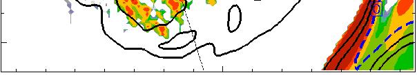
7 Example diagnostics converted to EDR 3.5-hr forecast 3.3km conus grid* *courtesy J-H Kim, NASA Ames 7


8 Verification: PIREPs and In situ EDR measurements PIREPs Verbal subjective Mean position error ~ 50 km Automated EDR (ε 1/3 m 2/3 / s) estimates Calculation performed onboard ACMS, data transferred via 8Hz Peak + mean over 1 min. Position uncertainty < 10 km Currently deployed or planned to be deployed on ~ 70 UAL B s ~ 90 DAL B s, s ~ 100 DAL B ERs and -400ERs ~ 400 SWA B s,-700s Currently ~ 5000/hour Compared to 400/day PIREPs Must use both so need to be able to convert from pirep to edr -> simple mapping developed PIREPS Red=severe, blue=mwt 24 hrs of UAL insitu 24 hrs of DAL insitu 03 Jan
 - Binary discrimination i i performance of smooth vs.")

9 Current GTG3 RUC-based performance (6-hr fcst ROC curves 12 mos. valid18z) - Binary discrimination i i performance of smooth vs. moderateor-greater (MOG) PIREPS + in situ edr data of predic cting MOG obability Pro GTG3 Ellrod1 EDR UBF, LHFK SGS TKE Individual diagnostics Null-MOG GTG3 AUC=0.812 Probability bilit of false alarms High threshold Low threshold (Predict no turb) (Predict turb everywhere) 9
10 Other diagnostic combination strategies* Cross-Validation ROC Curves 6-hr forecast 13km WRFRAP verified against insitu edr only Edr >03vsedr >0.3 < FL>200 Random forest AUC: 0.85 KNN AUC:0.83 Logistic Regression AUC: 0.80 Current GTG AUC: 0.78/0.79 *Courtesy John Williams
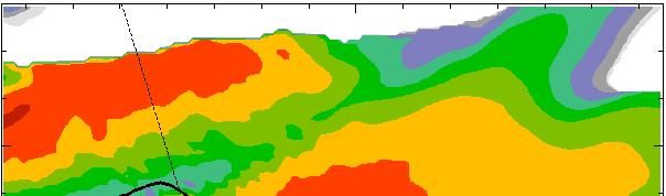
11 GFS Global GTG UKMET GTG output based on 3 global models for the same case. Contours are EDR (m 2/3 s 1 ) at FL Dec hr fcst valid 18Z All models used native vertical grids All models used same number of diagnostics All models used same thresholds ECMWF

12 Characterization studies Use research simulation models to recreate both the large scale forcing and smaller scale turbulence to determine origins of recorded turbulence encounters Can control simulation options to isolate effects Cloud/latent heating, Cloud top radiative cooling Typically use multi-nested approach 12


13 Simulations to identify relation of cirrus bands to turbulence* *Knox et al. Transverse cirrus bands in weather systems: a grand tour of an enduring enigma Weather 2006
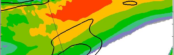
14 Example cirrus bands/turbulence 15 Nov 2011* FL310 Forecasted turbulent areas *Courtesy MelissaThomas DAL


 MCS")


15 Simulations of two cirrus bands cases 17 June 2005 Moderate and severe turbulence insitu edr measurements near Transverse (Radial) MCS Outflow Bands over central US - Trier & Sharman MWR Trier et al. JAS Sep 2010 : Moderate and severe turbulence reported in vicinity of mid-latitude cyclone over western Pacific Ocean - Kim et al. submitted to MWR 15


16 Example 1. Out-of-cloud CIT near MCS* In situ edr + wind vectors Note bands are transverse to wind vectors Observed turbulence 0905 UTC 16 June 43 N 40 N Model TKE 37 N Courtesy UW CIMSS *Trier and Sharman, MWR, 2009 *Trier et al JAS 2010 ARWRF simulation =3 km


17 MCS CIT mechanism No cloud With cloud With cloud No cloud Strong vertical shear at flight levels due almost entirely to MCS outflow on north side Vertical shear at flight levels on south side weaker because easterly outflow winds and shear are opposed by their westerly environmental (adiabatic) counterparts


 Observed Turbulence @ 37 Kft")

 Observations and MCS-Scale Simulations")
18 Observations and WRF-Simulations of the 17 June 2005 MCS Case 600m nest IR Satellite at 0950 UTC 17 June 2005 Simulated Cloud Top Temperature (0950 UTC, t = 5.8 h ) Observed 37 Kft ( UTC) L=light, M=Moderate Turbulence UA 776 Trier and Sharman (2009, Mon. Wea. Rev.) Observations and MCS-Scale Simulations Trier et al. (2010, J. Atmos. Sci.) High-Resolution Simulation and Analysis of Radial Bands
19 4-hour Loop of Brightness Temperature, 12-km Moist Static Instability N < 0 and km Vertical Shear from UTC 17 June with Dt = 10 min 2 m North East Tb Anvil bands originate within zones of moist static instability Bands are aligned along the anvil vertical shear vector Similar to horizontal convective rolls in boundary layer arising from thermal instability

")


20 Case 2: cirrus bands in mid- latitude cyclone 9 Sep 2010* Control (CTL) Simulation No Cloud Radiative Feedback (NCR) Simulation x x x x Approximate Locations of Observed Turbulence Approximate Locations of Observed Turbulence Domain 3 = 3.3 km Domain 3 = 3.3 km *J-H Kim, submitted to MWR 500 km Model-Derived Reflectivity and Sea-Level Pressure at 0300 UTC 9 Sep (t = 9 h)


 CTL at")


21 Relation of wind shear vectors and stability to bands CTL at 2140 UTC 8 Sep 2010 (t = 3.67 h) CTL at 2340 UTC 8 Sep 2010 (t = 5.67 h) Brightness Temperature, km Moist Static Stability, 200 km km Wind Shear vectors


22 Brightness Temperature, and km MSL Moist Static Stability Control (CTL) Run No Cloud-Radiative Feedback (NCR) Run 2220 UTC 8 Sep (t = 4.33 h) 2310 UTC 8 Sep (t = 5.17 h) 200 km
23 Simulation of bands - summary Both cases show bands owe their existence to convective instability in anvil within background shear MCS case: background shear mainly from upper-level outflow Pacific mid-latitude cyclone case: shear mainly from jet stream Both have morphology akin to PBL rolls Since bands originate i from convectively unstable regions of anvil, it is not surprising that those areas are turbulent MCS case cloud-top radiative cooling encourages bands, in Pacific case it is crucial for bands i23
24 GTG Summary and future work Using an ensemble of turbulence diagnostics (GTG) instead of one diagnostic gives more robust performance Provides EDR Technique can be used with any input NWP model Longer term goals Forecast convective turbulence (CIT) Provide probabilistic forecasts Use of in situ edr provides valuable verification source Numerical simulations Use multi-nested approach to relate large scale to small scales for a variety of environments and turbulence sources Helps understand turbulence genesis which may ultimately lead to formulation of better diagnostics 24
Global aviation turbulence forecasting using the Graphical Turbulence Guidance (GTG) for the WAFS Block Upgrades
 for the WAFS Block Upgrades") Global aviation turbulence forecasting using the Graphical Turbulence Guidance (GTG) for the WAFS Block Upgrades R. Sharman 1, J.-H. Kim 2, and C. Bartholomew 3 National Center for Atmospheric Research,
Global aviation turbulence forecasting using the Graphical Turbulence Guidance (GTG) for the WAFS Block Upgrades R. Sharman 1, J.-H. Kim 2, and C. Bartholomew 3 National Center for Atmospheric Research,
SATELLITE SIGNATURES ASSOCIATED WITH SIGNIFICANT CONVECTIVELY-INDUCED TURBULENCE EVENTS
 SATELLITE SIGNATURES ASSOCIATED WITH SIGNIFICANT CONVECTIVELY-INDUCED TURBULENCE EVENTS Kristopher Bedka 1, Wayne Feltz 1, John Mecikalski 2, Robert Sharman 3, Annelise Lenz 1, and Jordan Gerth 1 1 Cooperative
Measuring In-cloud Turbulence: The NEXRAD Turbulence Detection Algorithm
 Measuring In-cloud Turbulence: The NEXRAD Turbulence Detection Algorithm John K. Williams,, Greg Meymaris,, Jason Craig, Gary Blackburn, Wiebke Deierling,, and Frank McDonough AMS 15 th Conference on Aviation,
Observations and simulations of turbulent processes in the upper troposphere and lower stratosphere
 Observations and simulations of turbulent processes in the upper troposphere and lower stratosphere Bob Sharman NCAR/RAL Boulder, CO USA sharman@ucar.edu GTP Workshop NCAR 28-30 May 2008 Collaborators:
Simulations of Midlatitude and Tropical Out-of-Cloud Convectively-Induced Turbulence
 Simulations of Midlatitude and Tropical Out-of-Cloud Convectively-Induced Turbulence Katelyn Barber University of North Dakota Turbulence Impact Mitigation Workshop 2018 katelyn.barber@und.edu 1 Zovko-Rajak
10.2 RESULTS FROM THE NCAR INTEGRATED TURBULENCE FORECASTING ALGORITHM (ITFA) FOR PREDICTING UPPER-LEVEL CLEAR-AIR TURBULENCE
 FOR PREDICTING UPPER-LEVEL CLEAR-AIR TURBULENCE") 10.2 RESULTS FROM THE NCAR INTEGRATED TURBULENCE FORECASTING ALGORITHM (ITFA) FOR PREDICTING UPPER-LEVEL CLEAR-AIR TURBULENCE Robert Sharman*, Claudia Tebaldi, Jamie Wolff, and Gerry Wiener National Center
10.2 RESULTS FROM THE NCAR INTEGRATED TURBULENCE FORECASTING ALGORITHM (ITFA) FOR PREDICTING UPPER-LEVEL CLEAR-AIR TURBULENCE Robert Sharman*, Claudia Tebaldi, Jamie Wolff, and Gerry Wiener National Center
Friends and Partners of Aviation Weather Fall Meeting Turbulence Session
 Friends and Partners of Aviation Weather Fall Meeting Turbulence Session October 24, 2013 Facilitators: Bob Sharman, National Center for Atmospheric Research Tammy Farrar, Federal Aviation Administration
Turbulence Measurements. Turbulence Measurements In Low Signal-to-Noise. Larry Cornman National Center For Atmospheric Research
 Turbulence Measurements In Low Signal-to-Noise Larry Cornman National Center For Atmospheric Research Turbulence Measurements Turbulence is a stochastic process, and hence must be studied via the statistics
WAFC London Research and Development (R&D) Plans for algorithm development UK Met Office
 Plans for algorithm development UK Met Office") SUMMARY OF PRESENTATIONS GIVEN TO THE WORLD AREA FORECAST CENTRE SCIENCE COORDINATION MEETING/4 (26 27 February 2013, College Park, Maryland, United States) INTRODUCTION World Area Forecast Centres (WAFC)
SUMMARY OF PRESENTATIONS GIVEN TO THE WORLD AREA FORECAST CENTRE SCIENCE COORDINATION MEETING/4 (26 27 February 2013, College Park, Maryland, United States) INTRODUCTION World Area Forecast Centres (WAFC)
INTEGRATED TURBULENCE FORECASTING ALGORITHM 2001 METEOROLOGICAL EVALUATION
 INTEGRATED TURBULENCE FORECASTING ALGORITHM 2001 METEOROLOGICAL EVALUATION Jeffrey A. Weinrich* Titan Systems Corporation, Atlantic City, NJ Danny Sims Federal Aviation Administration, Atlantic City, NJ
FAA Weather Research Plans
 FAA Weather Research Plans Presented to: Friends /Partners in Aviation Weather Vision Forum By: Ray Moy FAA Aviation Weather Office Date: Aviation Weather Research Program (AWRP) Purpose: Applied Research
In situ and remote sensing of turbulence in support of the aviation community. Larry B. Cornman National Center for Atmospheric Research USA
 In situ and remote sensing of turbulence in support of the aviation community Larry B. Cornman National Center for Atmospheric Research USA The Motivation Turbulence is the main cause of in-flight injuries
7.1 The Schneider Electric Numerical Turbulence Forecast Verification using In-situ EDR observations from Operational Commercial Aircraft
 7.1 The Schneider Electric Numerical Turbulence Forecast Verification using In-situ EDR observations from Operational Commercial Aircraft Daniel W. Lennartson Schneider Electric Minneapolis, MN John Thivierge
Transitioning NCAR s Aviation Algorithms into NCEP s Operations
 Transitioning NCAR s Aviation Algorithms into NCEP s Operations Hui-Ya Chuang 1, Yali Mao 1,2, and Binbin Zhou 1,2 1. EMC/NCEP/NOAA, College Park MD 2. I.M. System Group, Inc. AMS 18th Conference on Aviation,
FPAW October Pat Murphy & David Bright NWS Aviation Weather Center
 FPAW October 2014 Pat Murphy & David Bright NWS Aviation Weather Center Overview Ensemble & Probabilistic Forecasts What AWC Is Doing Now Ensemble Processor What s In Development (NOAA Aviation Weather
WAFS_Word. 2. Menu. 2.1 Untitled Slide
 WAFS_Word 2. Menu 2.1 Untitled Slide Published by Articulate Storyline 1. Introduction 1.1 Introduction Notes: As you will probably be aware, the traditional significant weather forecasts, usually seen
An Initial Assessment of a Clear Air Turbulence Forecasting Product. Ankita Nagirimadugu. Thomas Jefferson High School for Science and Technology
 An Initial Assessment of a Clear Air Turbulence Forecasting Product Ankita Nagirimadugu Thomas Jefferson High School for Science and Technology Alexandria, VA Abstract Clear air turbulence, also known
Update on CoSPA Storm Forecasts
 Update on CoSPA Storm Forecasts Haig August 2, 2011 This work was sponsored by the Federal Aviation Administration under Air Force Contract No. FA8721-05-C-0002. Opinions, interpretations, conclusions,
NWP in aviation: CAT diagnostics
 Federal Department of Home Affairs FDHA Federal Office of Meteorology and Climatology MeteoSwiss NWP in aviation: CAT diagnostics Pierre Eckert MeteoSwiss, Geneva Topics Motivation and backgroud Use of
NAM-WRF Verification of Subtropical Jet and Turbulence
 National Weather Association, Electronic Journal of Operational Meteorology, 2008-EJ3 NAM-WRF Verification of Subtropical Jet and Turbulence DOUGLAS N. BEHNE National Weather Service, Aviation Weather
Satellite-based Convection Nowcasting and Aviation Turbulence Applications
 Satellite-based Convection Nowcasting and Aviation Turbulence Applications Kristopher Bedka Cooperative Institute for Meteorological Satellite Studies (CIMSS), University of Wisconsin-Madison In collaboration
2.4 The complexities of thunderstorm avoidance due to turbulence and implications for traffic flow management
 2.4 The complexities of thunderstorm avoidance due to turbulence and implications for traffic flow management Robert D. Sharman* and John K. Williams National Center for Atmospheric Research, Boulder,
AVIATION APPLICATIONS OF A NEW GENERATION OF MESOSCALE NUMERICAL WEATHER PREDICTION SYSTEM OF THE HONG KONG OBSERVATORY
 P452 AVIATION APPLICATIONS OF A NEW GENERATION OF MESOSCALE NUMERICAL WEATHER PREDICTION SYSTEM OF THE HONG KONG OBSERVATORY Wai-Kin WONG *1, P.W. Chan 1 and Ivan C.K. Ng 2 1 Hong Kong Observatory, Hong
4.13 ESTIMATES OF UPPER LEVEL TURBULENCE BASED ON SECOND ORDER STRUCTURE FUNCTIONS DERIVED FROM NUMERICAL WEATHER PREDICTION MODEL OUTPUT
 4.13 ESTIMATES OF UPPER LEVEL TURBULENCE BASED ON SECOND ORDER STRUCTURE FUNCTIONS DERIVED FROM NUMERICAL WEATHER PREDICTION MODEL OUTPUT Rod Frehlich* and Robert Sharman Research Applications Program
Calculates CAT and MWT diagnostics. Paired down choice of diagnostics (reduce diagnostic redundancy) Statically weighted for all forecast hours
 Statically weighted for all forecast hours") 1 Major Upgrades All diagnostics mapped to Eddy Dissipation Rate ADDS now displays EDR values CAT diagnostic extended down to 1000 feet MSL & forecast hours 15 and 18 New Mountain Wave diagnostic CAT diagnostics
1 Major Upgrades All diagnostics mapped to Eddy Dissipation Rate ADDS now displays EDR values CAT diagnostic extended down to 1000 feet MSL & forecast hours 15 and 18 New Mountain Wave diagnostic CAT diagnostics
Extracting probabilistic severe weather guidance from convection-allowing model forecasts. Ryan Sobash 4 December 2009 Convection/NWP Seminar Series
 Extracting probabilistic severe weather guidance from convection-allowing model forecasts Ryan Sobash 4 December 2009 Convection/NWP Seminar Series Identification of severe convection in high-resolution
Robert Sharman*, Jamie Wolff, Tressa L. Fowler, and Barbara G. Brown National Center for Atmospheric Research, Boulder, CO USA
 J1.8 CLIMATOLOGIES OF UPPER-LEVEL TURBULENCE OVER THE CONTINENTAL U.S. AND OCEANS 1. Introduction Robert Sharman*, Jamie Wolff, Tressa L. Fowler, and Barbara G. Brown National Center for Atmospheric Research,
Predicting Clear-Air Turbulence from Diagnosis of Unbalanced Flow
 10.4 Predicting Clear-Air Turbulence from Diagnosis of Unbalanced Flow Steven E. Koch* and Fernando Caracena NOAA Research Forecast Systems Lab Boulder, Colorado 1. INTRODUCTION Over the last several years,
Advances in weather and climate science
 Advances in weather and climate science Second ICAO Global Air Navigation Industry Symposium (GANIS/2) 11 to 13 December 2017, Montreal, Canada GREG BROCK Scientific Officer Aeronautical Meteorology Division
En-route aircraft wake vortex encounter analysis in a high density air traffic region
 En-route aircraft wake vortex encounter analysis in a high density air traffic region Ulrich Schumann 1) and Robert Sharman 2) 1) Institut für Physik der Atmosphäre, DLR, Oberpfaffenhofen 2) Research Applications
Blend of UKMET and GFS 3hr increments F06 to F degree downloadable grid available on WIFS
 Blend of UKMET and GFS 3hr increments F06 to F36 1.25 degree downloadable grid available on WIFS WWW.AVIATIONWEATHER.GOV/WAFS Wind, Turbulence and Cb 2 3 New Products: All diagnostics mapped to Eddy Dissipation
Introduction to NCEP's time lagged North American Rapid Refresh Ensemble Forecast System (NARRE-TL)
") Introduction to NCEP's time lagged North American Rapid Refresh Ensemble Forecast System (NARRE-TL) Binbin Zhou 1,2, Jun Du 2, Geoff Manikin 2 & Geoff DiMego 2 1. I.M. System Group 2. EMC/NCEP/NWS/NOAA
Introduction to NCEP's time lagged North American Rapid Refresh Ensemble Forecast System (NARRE-TL) Binbin Zhou 1,2, Jun Du 2, Geoff Manikin 2 & Geoff DiMego 2 1. I.M. System Group 2. EMC/NCEP/NWS/NOAA
P2.2 REDUCING THE IMPACT OF NOISE ABATEMENT PRACTICES ON AIRPORT CAPACITY BY FORECASTING SITUATIONAL DEPENDENT AIRCRAFT NOISE PROPAGATION
 P2.2 REDUCING THE IMPACT OF NOISE ABATEMENT PRACTICES ON AIRPORT CAPACITY BY FORECASTING SITUATIONAL DEPENDENT AIRCRAFT NOISE PROPAGATION R. Sharman* and T. Keller Research Applications Program National
2012 and changes to the Rapid Refresh and HRRR weather forecast models
 2012 and 2013-15 changes to the Rapid Refresh and HRRR weather forecast models 31 October 2012 Stan Benjamin Steve Weygandt Curtis Alexander NOAA Earth System Research Laboratory Boulder, CO FPAW - 2012
The Use of GPS Radio Occultation Data for Tropical Cyclone Prediction. Bill Kuo and Hui Liu UCAR
 The Use of GPS Radio Occultation Data for Tropical Cyclone Prediction Bill Kuo and Hui Liu UCAR Current capability of the National Hurricane Center Good track forecast improvements. Errors cut in half
Evaluation of CIT Avoidance Guidelines. Turbulence PDT Task FY 2005 Year-End Progress Report
 Evaluation of CIT Avoidance Guidelines Turbulence PDT Task 05.7.3.13 FY 2005 Year-End Progress Report Deliverable 05.7.3.13.E1 Submitted by The National Center for Atmospheric Research Introduction In
R. Sharman*, L. Cornman, J. Williams National Center for Atmospheric Research, Boulder, CO, 80307
 3.3 THE FAA AWRP TURBULENCE PDT R. Sharman*, L. Cornman, J. Williams National Center for Atmospheric Research, Boulder, CO, 80307 S. Koch, W. Moninger NOAA/ Earth System Research Laboratory/Global Systems
1.4 SUPPORT VECTOR MACHINES FOR REGIONAL CLEAR-AIR TURBULENCE PREDICTION. Boulder, Colorado
 1.4 SUPPORT VECTOR MACHINES FOR REGIONAL CLEAR-AIR TURBULENCE PREDICTION Jennifer Abernethy* 1, and Robert Sharman 1 University of Colorado, Boulder National Center for Atmospheric Research* Boulder, Colorado
Convection-Resolving NWP with WRF. Section coordinator Ming Xue University of Oklahoma
 Convection-Resolving NWP with WRF Section coordinator Ming Xue University of Oklahoma Convection-resolving NWP Is NWP that explicitly treats moist convective systems ranging from organized MCSs to individual
Soo-Hyun Kim and Hye-Yeong Chun*
 METEOROLOGICAL APPLICATIONS Meteorol. Appl. 23: 594 604 (2016) Published online in Wiley Online Library (wileyonlinelibrary.com) DOI: 10.1002/met.1581 Aviation turbulence encounters detected from aircraft
Evaluation of Ensemble Icing Probability Forecasts in NCEP s SREF, VSREF and NARRE-TL Systems
 Evaluation of Ensemble Icing Probability Forecasts in NCEP s, V and Systems Binbin Zhou 1,2, Jun Du 2, Geoff DeMigo 2 and Robert Sallee 3 1. I.M. System Group 2. Environmental Modeling Center of NCEP 3.
9.10 NUMERICAL SIMULATIONS OF THE WAKE OF KAUAI WITH IMPLICATIONS FOR THE HELIOS FLIGHTS
 9.10 NUMERICAL SIMULATIONS OF THE WAKE OF KAUAI WITH IMPLICATIONS FOR THE HELIOS FLIGHTS T. P. Lane 1, R. D. Sharman 1, R G. Frehlich 1, J. M. Brown 2, J. T. Madura 3, and L. J. Ehernberger 4 1 National
Master thesis in meteorology, oceanography and climate, 30 hp. Case study of CAT over the North Atlantic Ocean. Kristoffer Molarin
 Master thesis in meteorology, oceanography and climate, 30 hp Case study of CAT over the North Atlantic Ocean Kristoffer Molarin Supervisors: Tomas Mårtensson and Gunilla Svensson Department of Meteorology
Qualitative Reasoning About Small-Scale Turbulence in an Operational Setting
 Qualitative Reasoning About Small-Scale Turbulence in an Operational Setting Jennifer Abernethy 1,2 Elizabeth Bradley 1 and Robert Sharman 2 1 University of Colorado at Boulder 2 National Center for Atmospheric
Tropical Cyclone Formation/Structure/Motion Studies
 Tropical Cyclone Formation/Structure/Motion Studies Patrick A. Harr Department of Meteorology Naval Postgraduate School Monterey, CA 93943-5114 phone: (831) 656-3787 fax: (831) 656-3061 email: paharr@nps.edu
Motivation & Goal. We investigate a way to generate PDFs from a single deterministic run
 Motivation & Goal Numerical weather prediction is limited by errors in initial conditions, model imperfections, and nonlinearity. Ensembles of an NWP model provide forecast probability density functions
MEETING OF THE METEOROLOGY PANEL (METP) WORKING GROUP MOG (WAFS)
 WORKING GROUP MOG (WAFS)") International Civil Aviation Organization STUDY NOTE METPWGMOG/7/SN/23 21/03/18 MEETING OF THE METEOROLOGY PANEL (METP) WORKING GROUP MOG (WAFS) SEVENTH MEETING Offenbach, Germany, 11 to 13 April 2018
International Civil Aviation Organization STUDY NOTE METPWGMOG/7/SN/23 21/03/18 MEETING OF THE METEOROLOGY PANEL (METP) WORKING GROUP MOG (WAFS) SEVENTH MEETING Offenbach, Germany, 11 to 13 April 2018
Turbulence Avoidance Technologies
 Turbulence Avoidance Technologies The information contained herein is advisory only in nature. Modification Date: 01NOV2016 Revision: 0.0 Operations Scope: ALL AIRCRACT Briefing Owners: Tenille Cromwell
NHC Ensemble/Probabilistic Guidance Products
 NHC Ensemble/Probabilistic Guidance Products Michael Brennan NOAA/NWS/NCEP/NHC Mark DeMaria NESDIS/STAR HFIP Ensemble Product Development Workshop 21 April 2010 Boulder, CO 1 Current Ensemble/Probability
Peter J. Sousounis*, James L. Menard, and Roy Strasser Weather Services International Corporation Andover, MA
 J3.10 REAL TIME AVIATION FORECASTING AT WSI Peter J. Sousounis*, James L. Menard, and Roy Strasser Weather Services International Corporation Andover, MA 1. INTRODUCTION The paradigm for providing weather
P5.7 THE ADVANCED SATELLITE AVIATION WEATHER PRODUCTS (ASAP) INITIATIVE: PHASE I EFFORTS AT THE UNIVERSITY OF ALABAMA IN HUNTSVILLE
 INITIATIVE: PHASE I EFFORTS AT THE UNIVERSITY OF ALABAMA IN HUNTSVILLE") P5.7 THE ADVANCED SATELLITE AVIATION WEATHER PRODUCTS (ASAP) INITIATIVE: PHASE I EFFORTS AT THE UNIVERSITY OF ALABAMA IN HUNTSVILLE John R. Mecikalski #1, Todd A. Berendes #, U. S. Nair #, Wayne F. Feltz*,
P5.7 THE ADVANCED SATELLITE AVIATION WEATHER PRODUCTS (ASAP) INITIATIVE: PHASE I EFFORTS AT THE UNIVERSITY OF ALABAMA IN HUNTSVILLE John R. Mecikalski #1, Todd A. Berendes #, U. S. Nair #, Wayne F. Feltz*,
Oceanic Weather Product Development Team
 Oceanic Weather Product Development Team Cathy Kessinger, Ted Tsui, Paul Herzegh, Earle Williams, Gary Blackburn, Gary Ellrod ASAP Science Review 13-14 April 2005 2005 NASA ASAP Science Meeting, Boulder,
WMO Aeronautical Meteorology Scientific Conference 2017
 Session 1 Science underpinning meteorological observations, forecasts, advisories and warnings 1.6 Observation, nowcast and forecast of future needs 1.6.1 Advances in observing methods and use of observations
The Properties of Convective Clouds Over the Western Pacific and Their Relationship to the Environment of Tropical Cyclones
 The Properties of Convective Clouds Over the Western Pacific and Their Relationship to the Environment of Tropical Cyclones Principal Investigator: Dr. Zhaoxia Pu Department of Meteorology, University
STUDY UNIT SEVENTEEN GRAPHICAL AIRMAN S METEOROLOGICAL ADVISORY (G-AIRMET)
") STUDY UNIT SEVENTEEN GRAPHICAL AIRMAN S METEOROLOGICAL ADVISORY (G-AIRMET) 341 (10 pages of outline) 17.1 Product Description....................................................... 341 17.2 Issuance...............................................................
STUDY UNIT SEVENTEEN GRAPHICAL AIRMAN S METEOROLOGICAL ADVISORY (G-AIRMET) 341 (10 pages of outline) 17.1 Product Description....................................................... 341 17.2 Issuance...............................................................
ANALYSIS OF TURBULENCE GENERATION BY GRAVITY WAVES WITHIN AN UPPER-TROPOSPHERIC FRONT
 4.11 ANALYSIS OF TURBULENCE GENERATION BY GRAVITY WAVES WITHIN AN UPPER-TROPOSPHERIC FRONT Steven E. Koch 1, Brian Jamison 1,2, Ed Tollerud 1, Cecelia Girz 1, Tracy Smith 1,2, Todd P. Lane 3, Ning Wang
TC/PR/RB Lecture 3 - Simulation of Random Model Errors
 TC/PR/RB Lecture 3 - Simulation of Random Model Errors Roberto Buizza (buizza@ecmwf.int) European Centre for Medium-Range Weather Forecasts http://www.ecmwf.int Roberto Buizza (buizza@ecmwf.int) 1 ECMWF
JOINT WMO TECHNICAL PROGRESS REPORT ON THE GLOBAL DATA PROCESSING AND FORECASTING SYSTEM AND NUMERICAL WEATHER PREDICTION RESEARCH ACTIVITIES FOR 2016
 JOINT WMO TECHNICAL PROGRESS REPORT ON THE GLOBAL DATA PROCESSING AND FORECASTING SYSTEM AND NUMERICAL WEATHER PREDICTION RESEARCH ACTIVITIES FOR 2016 New Zealand / Meteorological Service of New Zealand
Impact of GPS RO Data on the Prediction of Tropical Cyclones
 Impact of GPS RO Data on the Prediction of Tropical Cyclones Ying-Hwa Kuo, Hui Liu, UCAR Ching-Yuang Huang, Shu-Ya Chen, NCU Ling-Feng Hsiao, Ming-En Shieh, Yu-Chun Chen, TTFRI Outline Tropical cyclone
The document was not produced by the CAISO and therefore does not necessarily reflect its views or opinion.
 Version No. 1.0 Version Date 2/25/2008 Externally-authored document cover sheet Effective Date: 4/03/2008 The purpose of this cover sheet is to provide attribution and background information for documents
Development of Super Ensemble-based Aviation Turbulence Guidance (SEATG) for Air Traffic Management
 for Air Traffic Management") 4.3, Fourth Aviation, Range, and Aerospace Meteorology Special Symposium in Atlanta, GA, Feb. 02-06, 2014. Development of Super Ensemble-based Aviation Turbulence Guidance (SEATG) for Air Traffic Management
4.3, Fourth Aviation, Range, and Aerospace Meteorology Special Symposium in Atlanta, GA, Feb. 02-06, 2014. Development of Super Ensemble-based Aviation Turbulence Guidance (SEATG) for Air Traffic Management
Characterization of Forecast Uncertainty by Means of Ensemble Techniques
 Characterization of Forecast Uncertainty by Means of Ensemble Techniques Matthias Steiner National Center for Atmospheric Research Boulder, Colorado, USA Email: msteiner@ucar.edu Short-Term Weather Forecasting
The Nowcasting Demonstration Project for London 2012
 The Nowcasting Demonstration Project for London 2012 Susan Ballard, Zhihong Li, David Simonin, Jean-Francois Caron, Brian Golding, Met Office, UK Introduction The success of convective-scale NWP is largely
WMO Aeronautical Meteorology Scientific Conference 2017
 Session 3 Impacts of climate change and variability on aviation operations and associated science requirements 3.1 Jet stream position and intensity and related phenomena Aircraft observations and reanalysis
Global Response of Clear-Air Turbulence to Climate Change. Professor Paul D. Williams University of Reading, UK
 Global Response of Clear-Air Turbulence to Climate Change Professor Paul D. Williams University of Reading, UK Climate change impacts on aviation Rising sea levels and storm surges threaten coastal airports
Forecasting of Optical Turbulence in Support of Realtime Optical Imaging and Communication Systems
 Forecasting of Optical Turbulence in Support of Realtime Optical Imaging and Communication Systems Randall J. Alliss and Billy Felton Northrop Grumman Corporation, 15010 Conference Center Drive, Chantilly,
Typhoon Relocation in CWB WRF
 Typhoon Relocation in CWB WRF L.-F. Hsiao 1, C.-S. Liou 2, Y.-R. Guo 3, D.-S. Chen 1, T.-C. Yeh 1, K.-N. Huang 1, and C. -T. Terng 1 1 Central Weather Bureau, Taiwan 2 Naval Research Laboratory, Monterey,
Wind data collected by a fixed-wing aircraft in the vicinity of a typhoon over the south China coastal waters
 Wind data collected by a fixed-wing aircraft in the vicinity of a typhoon over the south China coastal waters P.W. Chan * and K.K. Hon Hong Kong Observatory, Hong Kong, China Abstract: The fixed-wing aircraft
Severe storm forecast guidance based on explicit identification of convective phenomena in WRF-model forecasts
 Severe storm forecast guidance based on explicit identification of convective phenomena in WRF-model forecasts Ryan Sobash 10 March 2010 M.S. Thesis Defense 1 Motivation When the SPC first started issuing
Routing options to reduce aviation s climate impact
 www.dlr.de Chart 1 Routing options to reduce aviation s climate impact Volker Grewe DLR-Institut für Physik der Atmosphäre & Chair for Climate Effects of Aviation, TU Delft Aerospace Engineering www.dlr.de
Climatology of Upper-Level Turbulence over the Contiguous United States
 2198 J O U R N A L O F A P P L I E D M E T E O R O L O G Y A N D C L I M A T O L O G Y VOLUME 47 Climatology of Upper-Level Turbulence over the Contiguous United States J. K. WOLFF AND R. D. SHARMAN Research
An ensemble based turbulence forecasting system
 METEOROLOGICAL APPLICATIONS Meteorol. Appl. 21: 12 19 (2014) Published online 22 February 2013 in Wiley Online Library (wileyonlinelibrary.com) DOI: 10.1002/met.1373 An ensemble based turbulence forecasting
Weather Impact Modeling. Based on Joe Mitchell s slides
 Weather Impact Modeling Based on Joe Mitchell s slides Old Paradigm: Human Centric Weather Aviation traffic manager Forecast Products ATM Automation tailored to aviation needs ready for integration New
Improved rainfall and cloud-radiation interaction with Betts-Miller-Janjic cumulus scheme in the tropics
 Improved rainfall and cloud-radiation interaction with Betts-Miller-Janjic cumulus scheme in the tropics Tieh-Yong KOH 1 and Ricardo M. FONSECA 2 1 Singapore University of Social Sciences, Singapore 2
Masahiro Kazumori, Takashi Kadowaki Numerical Prediction Division Japan Meteorological Agency
 Development of an all-sky assimilation of microwave imager and sounder radiances for the Japan Meteorological Agency global numerical weather prediction system Masahiro Kazumori, Takashi Kadowaki Numerical
J th Conference on Aviation, Range, and Aerospace Meteorology, 90th AMS Annual Meeting, Atlanta, GA, Jan, 2010
 J12.3 14th Conference on Aviation, Range, and Aerospace Meteorology, 90th AMS Annual Meeting, Atlanta, GA, 17-21 Jan, 20 Introduction to the NCEP Very Short Range Ensemble Forecast System (VSREF) Binbin
A COMPARISON OF VERY SHORT-TERM QPF S FOR SUMMER CONVECTION OVER COMPLEX TERRAIN AREAS, WITH THE NCAR/ATEC WRF AND MM5-BASED RTFDDA SYSTEMS
 A COMPARISON OF VERY SHORT-TERM QPF S FOR SUMMER CONVECTION OVER COMPLEX TERRAIN AREAS, WITH THE NCAR/ATEC WRF AND MM5-BASED RTFDDA SYSTEMS Wei Yu, Yubao Liu, Tom Warner, Randy Bullock, Barbara Brown and
Canadian Meteorological and Oceanographic Society and American Meteorological Society 21 st Conference on Numerical Weather Prediction 31 May 2012
 Canadian Meteorological and Oceanographic Society and American Meteorological Society 21 st Conference on Numerical Weather Prediction 31 May 2012 The High Resolution Rapid Refresh (): An hourly updating
Advanced Weather Technology
 Advanced Weather Technology Tuesday, October 16, 2018, 1:00 PM 2:00 PM PRESENTED BY: Gary Pokodner, FAA WTIC Program Manager Agenda Overview Augmented reality mobile application Crowd Sourcing Visibility
2.1 OBSERVATIONS AND THE PARAMETERISATION OF AIR-SEA FLUXES DURING DIAMET
 2.1 OBSERVATIONS AND THE PARAMETERISATION OF AIR-SEA FLUXES DURING DIAMET Peter A. Cook * and Ian A. Renfrew School of Environmental Sciences, University of East Anglia, Norwich, UK 1. INTRODUCTION 1.1
Introduction of climate monitoring and analysis products for one-month forecast
 Introduction of climate monitoring and analysis products for one-month forecast TCC Training Seminar on One-month Forecast on 13 November 2018 10:30 11:00 1 Typical flow of making one-month forecast Observed
Weather Forecasting. March 26, 2009
 Weather Forecasting Chapter 13 March 26, 2009 Forecasting The process of inferring weather from a blend of data, understanding, climatology, and solutions of the governing equations Requires an analysis
NEXRAD Turbulence Detection Algorithm (NTDA) and CIT Avoidance Guidelines and D-CIT Development. FY 2008 Year-End Status Report
 and CIT Avoidance Guidelines and D-CIT Development. FY 2008 Year-End Status Report") NEXRAD Turbulence Detection Algorithm (NTDA) and CIT Avoidance Guidelines and D-CIT Development FY 2008 Year-End Status Report on Turbulence RT Tasks 08.7.3.1.1, 08.7.3.1.2, and 08.7.3.13 Provided in fulfillment
NEXRAD Turbulence Detection Algorithm (NTDA) and CIT Avoidance Guidelines and D-CIT Development FY 2008 Year-End Status Report on Turbulence RT Tasks 08.7.3.1.1, 08.7.3.1.2, and 08.7.3.13 Provided in fulfillment
Convection-Permitting Simulations of the Environment Supporting Widespread Turbulence within the Upper-Level Outflow of a Mesoscale Convective System
 1972 M O N T H L Y W E A T H E R R E V I E W VOLUME 137 Convection-Permitting Simulations of the Environment Supporting Widespread Turbulence within the Upper-Level Outflow of a Mesoscale Convective System
AMPS Update June 2016
 AMPS Update June 2016 Kevin W. Manning Jordan G. Powers Mesoscale and Microscale Meteorology Laboratory National Center for Atmospheric Research Boulder, CO 11 th Antarctic Meteorological Observation,
FLYSAFE meteorological hazard nowcasting driven by the needs of the pilot
 FLYSAFE meteorological hazard nowcasting driven by the needs of the pilot R. W. Lunnon, Met Office, Exeter, EX1 3PB, United Kingdom., Thomas Hauf, Thomas Gerz, and Patrick Josse. 1. Introduction The FLYSAFE
WMO Aeronautical Meteorology Scientific Conference 2017
 Session 1 Science underpinning meteorological observations, forecasts, advisories and warnings 1.3 Aerodrome throughput 1.3.1 Wake vortex detection and prediction Frequent-output sub-kilometric NWP models
P3.1 Development of MOS Thunderstorm and Severe Thunderstorm Forecast Equations with Multiple Data Sources
 P3.1 Development of MOS Thunderstorm and Severe Thunderstorm Forecast Equations with Multiple Data Sources Kathryn K. Hughes * Meteorological Development Laboratory Office of Science and Technology National
12.2 PROBABILISTIC GUIDANCE OF AVIATION HAZARDS FOR TRANSOCEANIC FLIGHTS
 12.2 PROBABILISTIC GUIDANCE OF AVIATION HAZARDS FOR TRANSOCEANIC FLIGHTS K. A. Stone, M. Steiner, J. O. Pinto, C. P. Kalb, C. J. Kessinger NCAR, Boulder, CO M. Strahan Aviation Weather Center, Kansas City,
Developing a Global Turbulence and Convection Nowcast and Forecast System
 1st AIAA Atmospheric and Space Environments Conference 22-25 June 2009, San Antonio, Texas AIAA 2009-3634 Developing a Global Turbulence and Convection Nowcast and Forecast System John K. Williams 1, Robert
Recommendations on trajectory selection in flight planning based on weather uncertainty
 Recommendations on trajectory selection in flight planning based on weather uncertainty Philippe Arbogast, Alan Hally, Jacob Cheung, Jaap Heijstek, Adri Marsman, Jean-Louis Brenguier Toulouse 6-10 Nov
Boundary Layer Turbulence Index: Progress and Recent Developments
 Boundary Layer Turbulence Index: Progress and Recent Developments Kenneth L. Pryor Center for Satellite Applications and Research (NOAA/NESDIS) Camp Springs, MD 1. Introduction Turbulence is a frequently
Aircraft-based Observations: Impact on weather forecast model performance
 Aircraft-based Observations: Impact on weather forecast model performance Stephen S. Weygandt Eric James, Stan Benjamin, Bill Moninger, Brian Jamison, Geoff Manikin* NOAA Earth System Research Laboratory
Tropical Cyclone Intensity and Structure Changes in relation to Tropical Cyclone Outflow
 DISTRIBUTION STATEMENT A. Approved for public release; distribution is unlimited. Tropical Cyclone Intensity and Structure Changes in relation to Tropical Cyclone Outflow Patrick A. Harr Department of
Extratropical and Polar Cloud Systems
 Extratropical and Polar Cloud Systems Gunilla Svensson Department of Meteorology & Bolin Centre for Climate Research George Tselioudis Extratropical and Polar Cloud Systems Lecture 1 Extratropical cyclones
The Impact of Horizontal Resolution and Ensemble Size on Probabilistic Forecasts of Precipitation by the ECMWF EPS
 The Impact of Horizontal Resolution and Ensemble Size on Probabilistic Forecasts of Precipitation by the ECMWF EPS S. L. Mullen Univ. of Arizona R. Buizza ECMWF University of Wisconsin Predictability Workshop,
Observed Structure and Environment of Developing and Nondeveloping Tropical Cyclones in the Western North Pacific using Satellite Data
 DISTRIBUTION STATEMENT A. Approved for public release; distribution is unlimited. Observed Structure and Environment of Developing and Nondeveloping Tropical Cyclones in the Western North Pacific using
The Influence of Atmosphere-Ocean Interaction on MJO Development and Propagation
 DISTRIBUTION STATEMENT A. Approved for public release; distribution is unlimited. The Influence of Atmosphere-Ocean Interaction on MJO Development and Propagation PI: Sue Chen Naval Research Laboratory
Tropical Storm List
 Tropical Storm Email List http://tstorms.org/ tropical-storms@tstorms.org Tropical-Storms is a mailing list only for those who are professionally active in either the research or forecasting of tropical
AN ENSEMBLE STRATEGY FOR ROAD WEATHER APPLICATIONS
 11.8 AN ENSEMBLE STRATEGY FOR ROAD WEATHER APPLICATIONS Paul Schultz 1 NOAA Research - Forecast Systems Laboratory Boulder, Colorado 1. INTRODUCTION In 1999 the Federal Highways Administration (FHWA) initiated