High-Impact Weather Events Associated with Interacting Tropical Cyclones over the Western Pacific in August 2016
|
|
|
- Susanna Poole
- 5 years ago
- Views:
Transcription
1 High-Impact Weather Events Associated with Interacting Tropical Cyclones over the Western Pacific in August 2016 Lance F. Bosart, Philippe P. Papin, and Alicia M. Bentley, and Tomer Burg GEWEX-2018 Open Science Conference Session 17: Storms and High-Impact Weather Tuesday 8 May 2018 Canmore, Alberta, Canada Support Provided by NSF Grants AGS and AGS
2 Motivation A story of binary and trinary tropical cyclone interac2ons in the Western Pacific in August 2016 and their resul2ng impacts

3 Western Pacific TC Tracks: August 2016 Chanthu Aug 980 hpa; 60kt Mindulle Aug 975 hpa; 75kt Lionrock Aug 940 hpa; 100kt Kompasu Aug 994 hpa; 40kt

 Over 1 billion")
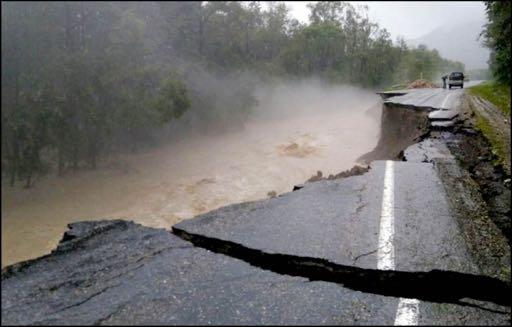
4 Impacts Source: h*p:// Catastrophic flooding in Japan, Russia, North and South Korea Over 500 deaths (most in North Korea) Over 1 billion dollars in damage (USD) Source:
5 TC Lionrock s Timeline: The Motivational Story Pre-TC Lionrock: TCs Conson/Chanthu perturb Pacific PV waveguide; PV streamer forms TC Lionrock: Develops from interacbon of a PV streamer with a WPAC monsoon gyre Forms via the tropical transibon process in northern part of gyre Moves W/SW and reaches peak intensity east of Taiwan Turns to the NE aker capture by a digging upper-level trough Triggers a predecessor rainfall event with flooding rains over Japan Undergoes ET, merges with an EC, and produces flooding in East Asia
6 Datasets ERA-5 (available from ; Hersbach et al. 2017) GPM-IMERG v3 (Huffman et al. 2017) GridSat-B1 v2 (Knapp et al. 2011)


7 Mean (Left) and Anomaly (Right) 250-hPa Streamfunction Aug hPa streamfunction Aug hPa streamfunction anomaly Aug 2016 Source: NOAA/ESRL PSD Map Room
8 Loops Lionrock and TC Friends
, TC tracks annotated")
9 Loops: Lionrock and TC Friends GPM IMERG summed precipitation total (shaded, mm), TC tracks annotated on plot
10 Loops: Lionrock and TC Friends GPM IMERG summed precipitation total from August 2016 (shaded, mm), TC tracks annotated on plot

11 Loops: Lionrock and TC Friends GPM IMERG summed precipitation total from August 2016 (shaded, mm), TC tracks annotated on plot Japan TC landfall statistics Credit JMA & Naoko Sakaeda Aug West Pacific TC average: 5.9 Aug TC < 300km of Japan: 3.4 Aug TC landfalls in Japan: 0.9 August max TC landfalls: 4 (1962 & 2016; record: ) 2016: Chanthu, Mindulle, Kompasu, Lionrock (Conson PTC before landfall)
, temperature (red dashed lines, every 4 C), winds (barbs, kt), TC tracks annotated on")
12 Loops: Lionrock and TC Friends 500-hPa cyclonic vorticity (shaded, > s -1 ), geopotential height (black contours, every 3 dam), temperature (red dashed lines, every 4 C), winds (barbs, kt), TC tracks annotated on plot
, winds (vectors, m s -1 ), TC tracks annotated")
13 Loops: Lionrock and TC Friends 350-K potential vorticity (shaded, PVU), winds (vectors, m s -1 ), TC tracks annotated on plot
14 Stills Summary of TC Lionrock Timeline
, TC tracks annotated on plot Diabatic ridge building Monsoon")
15 Tropical Transition of TC Lionrock GridSat brightness temperature (shaded, C), TC tracks annotated on plot Diabatic ridge building Monsoon Trough
, winds")

16 Tropical Transition of TC Lionrock 350-K potential vorticity (shaded, PVU), winds (vectors, m s -1 ), TC tracks annotated on plot Diabatic ridge building Remnant PV Streamer
, 1000 300-hPa integrated vapor transport (vectors, > 250 kg m -1 s -1 ),")
 Center of Monsoon Gyre Monsoon")
17 Tropical Transition of TC Lionrock Precipitable water (shaded, > s -1 ), hPa integrated vapor transport (vectors, > 250 kg m -1 s -1 ), integrated moisture flux convergence (white contours, > 50 kg m -2 s -1 ), sea level pressure (black contours, every 4 hpa) Center of Monsoon Gyre Monsoon Trough
, TC tracks annotated on plot Diaba%c ridge")
18 TC Lionrock s trinary interaction with TCs Mindulle and Kompasu GridSat brightness temperature (shaded, C), TC tracks annotated on plot Diaba%c ridge building


19 TC Lionrock s trinary interaction with TCs Mindulle and Kompasu 350-K potential vorticity (shaded, PVU), winds (vectors, m s -1 ), TC tracks annotated on plot Diabatic ridge building PV Streamer #2
, TC tracks annotated on plot Diaba%c ridge")
20 TC Lionrock s trinary interaction with TCs Mindulle and Kompasu GridSat brightness temperature (shaded, C), TC tracks annotated on plot Diaba%c ridge building
, winds (vectors, m s -1 ), TC tracks annotated on plot Diaba/c ridge building PV")
21 TC Lionrock s trinary interaction with TCs Mindulle and Kompasu 350-K potential vorticity (shaded, PVU), winds (vectors, m s -1 ), TC tracks annotated on plot Diaba/c ridge building PV Streamer #2
, TC tracks annotated on")
22 TC Lionrock Reaches Peak Intensity and Turns NE GridSat brightness temperature (shaded, C), TC tracks annotated on plot
, TC tracks annotated on plot PRE Diabatic ridge")
23 Beginning ET and PRE Development GridSat brightness temperature (shaded, C), TC tracks annotated on plot PRE Diabatic ridge building
,")

24 Beginning ET and PRE Development 350-K potential vorticity (shaded, PVU), winds (vectors, m s -1 ), TC tracks annotated on plot PRE Diaba(c ridge building
, sea level pressure (black contours, every 4 hpa) PRE Diaba(c ridge")
25 Beginning ET and PRE Development Precipitable water (shaded, > s -1 ), hPa integrated vapor transport (vectors, > 250 kg m -1 s -1 ), integrated moisture flux convergence (white contours, > 50 kg m -2 s -1 ), sea level pressure (black contours, every 4 hpa) PRE Diaba(c ridge building
, 600 400-hPa layer mean upward vertical motion (red contours, < -5 10-3 hpa s -1 ), Precipitable Water (shaded, mm) PRE Diabatic ridge")
26 Beginning ET and PRE Development 200-hPa winds (shaded, > 20 m s -1 ), hPa layer mean PV (gray contours, PVU), hPa layer mean irrotational wind (vectors, m s -1 ), hPa layer mean upward vertical motion (red contours, < hpa s -1 ), Precipitable Water (shaded, mm) PRE Diabatic ridge building


27 Beginning ET and PRE Development 500-hPa standardized geopotential height anomalies (shaded, σ), 500-hPa geopotential heights (black contours, dam) 0000 UTC 28 Aug UTC 30 Aug 2016 L L Extraordinarily rare mid-latitude trough for time of year 500-hPa standardized geopotential height anomaly < 6 sigma!
, TC tracks annotated on plot Diaba%c ridge")
28 Capture of TC Lionrock GridSat brightness temperature (shaded, C), TC tracks annotated on plot Diaba%c ridge building
, TC tracks annotated on plot Diaba%c ridge building PV")
29 Capture of TC Lionrock 350-K potential vorticity (shaded, PVU), winds (vectors, m s -1 ), TC tracks annotated on plot Diaba%c ridge building PV Hook
, 600 400-hPa layer mean upward vertical motion (red contours, < -5 10-3 hpa s -1 ), Precipitable Water (shaded, mm) Diaba%c ridge building")
30 Capture of TC Lionrock 200-hPa winds (shaded, > 20 m s -1 ), hPa layer mean PV (gray contours, PVU), hPa layer mean irrotational wind (vectors, m s -1 ), hPa layer mean upward vertical motion (red contours, < hpa s -1 ), Precipitable Water (shaded, mm) Diaba%c ridge building PV Hook
31 Conclusions High-amplitude, late-summer flow pa5ern leads to Rossby wave breaking (RWB), tropical-midlaatude interacaons, and meridional air mass exchanges RWB enables PV streamers to interact with a monsoon trough/gyre, contributes to several TC genesis events, and allows mulaple TCs to make landfall in Japan* TC Lionrock forms via tropical transiaon from a PV streamer disturbance, follows a complex track, and engages in binary and trinary interacaons with other TCs TC Lionrock interacts with an unusually strong early season trough, undergoes ET, and triggers a strong predecessor rain event and widespread flooding * Four landfalling TCs and one PTC is a modern August record for Japan ( )
32 Science Opportunities Quantify the trinary interaction of TC Lionrock with TCs Kompasu and Mindulle within a western Pacific monsoon gyre circulation Determine predictability limitations and uncertainties associated with the observed TC TC, TC gyre, and TC trough interactions Investigate whether the ET of Mindulle contributed to Lionrock s subsequent ET, downstream PRE formation, and Lionrock s subsequent TC Sandy-like left hook Ascertain whether diabatically driven downstream ridge building resulting from the Lionrock ET contributed to trough reestablishment near the Dateline Establish whether the Dateline trough, an eastern Pacific ridge, and a western North American trough contributed to endless summer in the eastern CONUS Evaluate whether the observed multiple TC TC and TC trough interactions over the western Pacific impacted the downstream ensemble predictability horizon
Multiscale Analyses of Inland Tropical Cyclone Midlatitude Jet Interactions: Camille (1969) and Danny (1997)
 and Danny (1997)") Multiscale Analyses of Inland Tropical Cyclone Midlatitude Jet Interactions: Camille (1969) and Danny (1997) Matthew Potter, Lance Bosart, and Daniel Keyser Department of Atmospheric and Environmental
Multiscale Analyses of Inland Tropical Cyclone Midlatitude Jet Interactions: Camille (1969) and Danny (1997) Matthew Potter, Lance Bosart, and Daniel Keyser Department of Atmospheric and Environmental
7 December 2016 Tokyo Climate Center, Japan Meteorological Agency
 Summary of the 2016 Asian Summer Monsoon 7 December 2016 Tokyo Climate Center, Japan Meteorological Agency This report summarizes the characteristics of the surface climate and atmospheric/oceanographic
1. INTRODUCTION: 2. DATA AND METHODOLOGY:
 27th Conference on Hurricanes and Tropical Meteorology, 24-28 April 2006, Monterey, CA 3A.4 SUPERTYPHOON DALE (1996): A REMARKABLE STORM FROM BIRTH THROUGH EXTRATROPICAL TRANSITION TO EXPLOSIVE REINTENSIFICATION
1. Introduction. 2. Verification of the 2010 forecasts. Research Brief 2011/ February 2011
 Research Brief 2011/01 Verification of Forecasts of Tropical Cyclone Activity over the Western North Pacific and Number of Tropical Cyclones Making Landfall in South China and the Korea and Japan region
The Impact of the Extratropical Transition of Typhoon Dale (1996) on the Early Wintertime Stratospheric Circulation
 on the Early Wintertime Stratospheric Circulation") The Impact of the Extratropical Transition of Typhoon Dale (1996) on the Early 1996-97 Wintertime Stratospheric Circulation Andrea L. Lang 1, Jason M. Cordeira 2, Lance F. Bosart 1 and Daniel Keyser 1
The Impact of the Extratropical Transition of Typhoon Dale (1996) on the Early 1996-97 Wintertime Stratospheric Circulation Andrea L. Lang 1, Jason M. Cordeira 2, Lance F. Bosart 1 and Daniel Keyser 1
The 2009 Hurricane Season Overview
 The 2009 Hurricane Season Overview Jae-Kyung Schemm Gerry Bell Climate Prediction Center NOAA/ NWS/ NCEP 1 Overview outline 1. Current status for the Atlantic, Eastern Pacific and Western Pacific basins
Predecessor Rain Events: A Literature Review. By: Tony Viramontez
 Predecessor Rain Events: A Literature Review By: Tony Viramontez Introduction Predecessor Rain Event (PRE): meso- and subsynopticscale regions of high-impact heavy rainfall that occur well in advance of
Synoptic Meteorology
 M.Sc. in Meteorology Synoptic Meteorology [MAPH P312] Prof Peter Lynch Second Semester, 2004 2005 Seminar Room Dept. of Maths. Physics, UCD, Belfield. Part 9 Extratropical Weather Systems These lectures
Scale Interactions during the Formation of Typhoon Irving 边建谱 ELIZABETH A. RITCHIE GREG J. HOLLAND
 Scale Interactions during the Formation of Typhoon Irving 边建谱 ELIZABETH A. RITCHIE GREG J. HOLLAND Pre-research Fujiwhara: laboratory experiments in water (1921, 1923, 1931). Cloud clusters are a well-known
The Impacts on Extended-Range Predictability of Midlatitude Weather Patterns due to Recurving Tropical Cyclones
 The Impacts on Extended-Range Predictability of Midlatitude Weather Patterns due to Recurving Tropical Cyclones Patrick A. Harr and Heather M. Archambault Naval Postgraduate School, Monterey, CA Hurricane
Verification of the Seasonal Forecast for the 2005/06 Winter
 Verification of the Seasonal Forecast for the 2005/06 Winter Shingo Yamada Tokyo Climate Center Japan Meteorological Agency 2006/11/02 7 th Joint Meeting on EAWM Contents 1. Verification of the Seasonal
Towards a new understanding of monsoon depressions
 Towards a new understanding of monsoon depressions William Boos Dept. of Geology & Geophysics May 2, 25 with contributions from John Hurley & Naftali Cohen Financial support: What is a monsoon low pressure
Subtropical and Hybrid Systems IWTC VII Topic 1.6
 Subtropical and Hybrid Systems IWTC VII Topic 1.6 John R. Gyakum Department of Atmospheric and Oceanic Sciences McGill University, Montreal Canada Working group: John L. Beven II, Lance F. Bosart, Fermin
Recent studies on tropical cyclone landfalling in China
 Recent studies on tropical cyclone landfalling in China Lei Xiaotu Shanghai Typhoon Institute CMA, Shanghai, China email: xtlei@21cn.com 1. Losses caused by tropical cyclones in China China is one of the
Tropical Cyclone Formation/Structure/Motion Studies
 Tropical Cyclone Formation/Structure/Motion Studies Patrick A. Harr Department of Meteorology Naval Postgraduate School Monterey, CA 93943-5114 phone: (831) 656-3787 fax: (831) 656-3061 email: paharr@nps.edu
Precipitation Structure and Processes of Typhoon Nari (2001): A Modeling Propsective
: A Modeling Propsective") Precipitation Structure and Processes of Typhoon Nari (2001): A Modeling Propsective Ming-Jen Yang Institute of Hydrological Sciences, National Central University 1. Introduction Typhoon Nari (2001) struck
Precipitation Structure and Processes of Typhoon Nari (2001): A Modeling Propsective Ming-Jen Yang Institute of Hydrological Sciences, National Central University 1. Introduction Typhoon Nari (2001) struck
A 40-year climatology of extratropical transition in the eastern North Pacific continued (and some other stuff)
") GOES-EAST image of Hurricane Dora, 1445 UTC 21 July 2011 A 40-year climatology of extratropical transition in the eastern North Pacific continued (and some other stuff) Elizabeth A. Ritchie and Kimberly
GOES-EAST image of Hurricane Dora, 1445 UTC 21 July 2011 A 40-year climatology of extratropical transition in the eastern North Pacific continued (and some other stuff) Elizabeth A. Ritchie and Kimberly
A Climatology of the Extratropical Transition of Tropical Cyclones in the Western North Pacific
 A Climatology of the Extratropical Transition of Tropical Cyclones in the Western North Pacific Naoko KITABATAKE (Meteorological Research Institute / Japan Meteorological Agency) 1 Outline 1. Topic 1:
The Impact of air-sea interaction on the extratropical transition of tropical cyclones
 The Impact of air-sea interaction on the extratropical transition of tropical cyclones Sarah Jones Institut für Meteorologie und Klimaforschung Universität Karlsruhe / Forschungszentrum Karlsruhe 1. Introduction
What does a cloud-resolving model bring during an extratropical transition?
 What does a cloud-resolving model bring during an extratropical transition? Florian Pantillon (1) Jean-Pierre Chaboureau (1) Christine Lac (2) Patrick Mascart (1) (1) Laboratoire d'aérologie, Toulouse,
Heavy rains and precipitable water anomalies August 2010 By Richard H. Grumm And Jason Krekeler National Weather Service State College, PA 16803
 Heavy rains and precipitable water anomalies 17-19 August 2010 By Richard H. Grumm And Jason Krekeler National Weather Service State College, PA 16803 1. INTRODUCTION Heavy rain fell over the Gulf States,
Department of Atmospheric Sciences, National Taiwan University, Taipei, Taiwan
 10A.4 TROPICAL CYCLONE FORMATIONS IN THE SOUTH CHINA SEA CHENG-SHANG LEE 1 AND YUNG-LAN LIN* 1, 2 1 Department of Atmospheric Sciences, National Taiwan University, Taipei, Taiwan 2 Taipei Aeronautic Meteorological
Dynamics of the Atmosphere. Large-scale flow with rotation and stratification
 12.810 Dynamics of the Atmosphere Large-scale flow with rotation and stratification Visualization of meandering jet stream Upper level winds from June 10th to July 8th 1988 from MERRA Red shows faster
Cooperative Institute for Research in Environmental Sciences (CIRES) CU-Boulder 2. National Oceanic and Atmospheric Administration
 CU-Boulder 2. National Oceanic and Atmospheric Administration") Moisture transport during the inland penetrating atmospheric river of early November 006 in the Pacific Northwest: A high-resolution model-based study Michael J. Mueller 1 and Kelly Mahoney 1 Cooperative
Moisture transport during the inland penetrating atmospheric river of early November 006 in the Pacific Northwest: A high-resolution model-based study Michael J. Mueller 1 and Kelly Mahoney 1 Cooperative
TROPICAL CYCLONES, TCS08, T-PARC and YOTC
 TROPICAL CYCLONES, TCS08, T-PARC and YOTC Russell L. Elsberry Graduate School of Engineering and Applied Sciences Department of Meteorology Naval Postgraduate School TCS08: Tropical Cyclone Structure 2008
Characteristics of 2014 summer climate over South Korea
 2 nd East Asia winter Climate Outlook Forum Characteristics of 2014 summer climate over South Korea October 30, 2014 So-Young Yim, E-hyung Park, and Hyun-Sook Jung Climate Prediction Division Korea Meteorological
THE EXTRATROPICAL TRANSITION OF TYPHOON WINNIE (1997): SELF-AMPLIFICATION AFTER LANDFALL
: SELF-AMPLIFICATION AFTER LANDFALL") THE EXTRATROPICAL TRANSITION OF TYPHOON WINNIE (1997): SELF-AMPLIFICATION AFTER LANDFALL Chih-Shin Liu *1,2 and George Tai-Jen Chen 2 1 Weather Forecast Center, Central Weather Bureau, 2 Department of
THE EXTRATROPICAL TRANSITION OF TYPHOON WINNIE (1997): SELF-AMPLIFICATION AFTER LANDFALL Chih-Shin Liu *1,2 and George Tai-Jen Chen 2 1 Weather Forecast Center, Central Weather Bureau, 2 Department of
Introduction of climate monitoring and analysis products for one-month forecast
 Introduction of climate monitoring and analysis products for one-month forecast TCC Training Seminar on One-month Forecast on 13 November 2018 10:30 11:00 1 Typical flow of making one-month forecast Observed
National Weather Service-Pennsylvania State University Weather Events
 National Weather Service-Pennsylvania State University Weather Events Heavy rainfall of 23 November 2011 by Richard H. Grumm National Weather Service State College PA 16803 Abstract:. A fast moving mid-tropospheric
1. INTRODUCTION. designed. The primary focus of this strategy was the extratropical transition (ET) of tropical cyclones based on the poleward
 of tropical cyclones based on the poleward") P1.98 THE THORPEX PACIFIC ASIAN REGIONAL CAMPAIGN (T-PARC) OBJECTIVE ON THE EXTRATROPICAL TRANSITION OF TROPICAL CYCLONES: OBSERVED CASES, THEIR STRUCTURE AND DOWNSTREAM IMPACTS P. A. Harr 1, S. C. Jones
P1.98 THE THORPEX PACIFIC ASIAN REGIONAL CAMPAIGN (T-PARC) OBJECTIVE ON THE EXTRATROPICAL TRANSITION OF TROPICAL CYCLONES: OBSERVED CASES, THEIR STRUCTURE AND DOWNSTREAM IMPACTS P. A. Harr 1, S. C. Jones
The Interdecadal Variation of the Western Pacific Subtropical High as Measured by 500 hpa Eddy Geopotential Height
 ATMOSPHERIC AND OCEANIC SCIENCE LETTERS, 2015, VOL. 8, NO. 6, 371 375 The Interdecadal Variation of the Western Pacific Subtropical High as Measured by 500 hpa Eddy Geopotential Height HUANG Yan-Yan and
Chapter 24 Tropical Cyclones
 Chapter 24 Tropical Cyclones Tropical Weather Systems Tropical disturbance a cluster of thunderstorms about 250 to 600 km in diameter, originating in the tropics or sub-tropics Tropical depression a cluster
Unseasonable weather conditions in Japan in August 2014
 Unseasonable weather conditions in Japan in August 2014 Summary of analysis by the TCC Advisory Panel on Extreme Climatic Events In an extraordinary session held at the Japan Meteorological Agency on 3
The feature of atmospheric circulation in the extremely warm winter 2006/2007
 The feature of atmospheric circulation in the extremely warm winter 2006/2007 Hiroshi Hasegawa 1, Yayoi Harada 1, Hiroshi Nakamigawa 1, Atsushi Goto 1 1 Climate Prediction Division, Japan Meteorological
Tropical-Extratropical Transition
 Tropical-Extratropical Transition Extratropical Transition A significant number of tropical cyclones move into the midlatitudes and transform into extratropical cyclones. This process is generally referred
Winds and Global Circulation
 Winds and Global Circulation Atmospheric Pressure Winds Global Wind and Pressure Patterns Oceans and Ocean Currents El Nino How is Energy Transported to its escape zones? Both atmospheric and ocean transport
Comparison of Wave Packets associated with Extratropical. Transition and Winter Cyclones. Ryan D. Torn. Gregory J. Hakim
 Generated using version 3.1.2 of the official AMS L A TEX template 1 Comparison of Wave Packets associated with Extratropical 2 Transition and Winter Cyclones 3 Ryan D. Torn Department of Atmospheric and
Introduction of products for Climate System Monitoring
 Introduction of products for Climate System Monitoring 1 Typical flow of making one month forecast Textbook P.66 Observed data Atmospheric and Oceanic conditions Analysis Numerical model Ensemble forecast
5D.6 EASTERLY WAVE STRUCTURAL EVOLUTION OVER WEST AFRICA AND THE EAST ATLANTIC 1. INTRODUCTION 2. COMPOSITE GENERATION
 5D.6 EASTERLY WAVE STRUCTURAL EVOLUTION OVER WEST AFRICA AND THE EAST ATLANTIC Matthew A. Janiga* University at Albany, Albany, NY 1. INTRODUCTION African easterly waves (AEWs) are synoptic-scale disturbances
Tropical Cyclone Genesis: What we know, and what we don t!
 Tropical Cyclone Genesis: What we know, and what we don t! Allison Wing! NSF Postdoctoral Research Fellow! Lamont-Doherty Earth Observatory! Columbia University! Overview! Climatology! What We Know! Theories!
Figure I.1-1 Annual mean temperature anomalies 2016 Circles indicate temperature anomalies from the baseline averaged in 5 x 5 grid boxes.
 Topics I Post-El Niño The annual anomaly of the global average surface temperature in 2016 was +0.45ºC above the 1981 2010 average, which was the highest since 1891. The mean surface temperature in Japan
Forced and internal variability of tropical cyclone track density in the western North Pacific
 Forced and internal variability of tropical cyclone track density in the western North Pacific Wei Mei 1 Shang-Ping Xie 1, Ming Zhao 2 & Yuqing Wang 3 Climate Variability and Change and Paleoclimate Working
1.4 CONNECTIONS BETWEEN PV INTRUSIONS AND TROPICAL CONVECTION. Beatriz M. Funatsu* and Darryn Waugh The Johns Hopkins University, Baltimore, MD
 1.4 CONNECTIONS BETWEEN PV INTRUSIONS AND TROPICAL CONVECTION Beatriz M. Funatsu* and Darryn Waugh The Johns Hopkins University, Baltimore, MD 1. INTRODUCTION Stratospheric intrusions into the tropical
A diagnostic study on heavy rainfall induced by landfalling Typhoon Utor (2013) in South China: 2. Postlandfall rainfall
 in South China: 2. Postlandfall rainfall") PUBLICATIONS RESEARCH ARTICLE This article is a companion to Meng and Wang [2016] doi:10.1002/2015jd024646. Key Points: ISOs played important roles in reviving Typhoon Utor inland Monsoonal surges contribute
PUBLICATIONS RESEARCH ARTICLE This article is a companion to Meng and Wang [2016] doi:10.1002/2015jd024646. Key Points: ISOs played important roles in reviving Typhoon Utor inland Monsoonal surges contribute
Impacts of Recent El Niño Modoki on Extreme Climate Conditions In East Asia and the United States during Boreal Summer
 Impacts of Recent El Niño Modoki on Extreme Climate Conditions In East Asia and the United States during Boreal Summer Hengyi Weng 1, Karumuri Ashok 1, Swadhin Behera 1, Suryachandra A. Rao 1 and Toshio
Examination of Tropical Cyclogenesis using the High Temporal and Spatial Resolution JRA-25 Dataset
 Examination of Tropical Cyclogenesis using the High Temporal and Spatial Resolution JRA-25 Dataset Masato Sugi Forecast Research Department, Meteorological Research Institute, Japan Correspondence: msugi@mri-jma.go.jp
Wet weeks in the warm season: Patterns and processes supporting widespread multi-day precipitation episodes!
 Wet weeks in the warm season: Patterns and processes supporting widespread multi-day precipitation episodes! Russ S. Schumacher and Samantha L. Lynch! Department of Atmospheric Science, Colorado State
No. 22 Autumn El Niño Outlook (October 2010 April 2011) 1. Contents. (a) (a) (b) (b) El Niño Outlook (October 2010 April 2011)
 1. Contents. (a) (a) (b) (b) El Niño Outlook (October 2010 April 2011)") No. 22 Autumn 2010 Contents El Niño Outlook (October 2010 April 2011) 1 JMA s Seasonal Numerical Ensemble Prediction for Winter 2010/2011 2 Cold-season Outlook for Winter 2010/2011 in Japan 4 Summary of
No. 22 Autumn 2010 Contents El Niño Outlook (October 2010 April 2011) 1 JMA s Seasonal Numerical Ensemble Prediction for Winter 2010/2011 2 Cold-season Outlook for Winter 2010/2011 in Japan 4 Summary of
Hurricane Harvey the Name says it all. by Richard H. Grumm and Charles Ross National Weather Service office State College, PA
 Hurricane Harvey the Name says it all by Richard H. Grumm and Charles Ross National Weather Service office State College, PA 16803. 1. Overview Hurricane Harvey crossed the Texas coast (Fig. 1) as a category
 Page 1 of 5 Home research global climate enso effects Research Effects of El Niño on world weather Precipitation Temperature Tropical Cyclones El Niño affects the weather in large parts of the world. The
Variations of Typhoon Activity in Asia - Global Warming and/or Natural Cycles?
 Variations of Typhoon Activity in Asia - Global Warming and/or Natural Cycles? Johnny Chan Guy Carpenter Asia-Pacific Climate Impact Centre City University of Hong Kong Tropical Cyclones Affecting the
Influence of the Western Pacific Subtropical High on summertime ozone variability in East China
 Influence of the Western Pacific Subtropical High on summertime ozone variability in East China Zijian Zhao 1 and Yuxuan Wang 1,2 1 Dept. Earth System Sciences, Tsinghua University, China 2 Dept. Earth
Recurving Western North Pacific Tropical Cyclones and Mid-Latitude Predictability
 GEOPHYSICAL RESEARCH LETTERS, VOL.???, XXXX, DOI:10.1002/, 1 2 Recurving Western North Pacific Tropical Cyclones and Mid-Latitude Predictability A. Aiyyer, 1 Corresponding author: A. Aiyyer, Department
Mesoscale Meteorology Assignment #3 Q-G Theory Exercise. Due 23 February 2017
 Mesoscale Meteorology Assignment #3 Q-G Theory Exercise 1. Consider the sounding given in Fig. 1 below. Due 23 February 2017 Figure 1. Skew T-ln p diagram from Tallahassee, FL (TLH). The observed temperature
ENSO, AO, and climate in Japan. 15 November 2016 Yoshinori Oikawa, Tokyo Climate Center, Japan Meteorological Agency
 ENSO, AO, and climate in Japan 15 November 2016 Yoshinori Oikawa, Tokyo Climate Center, Japan Meteorological Agency Aims of this lecture At the end of the yesterday s lecture, Hare-run said, - In the exercise
Chapter 24. Tropical Cyclones. Tropical Cyclone Classification 4/19/17
 Chapter 24 Tropical Cyclones Tropical Cyclones Most destructive storms on the planet Originate over tropical waters, but their paths often take them over land and into midlatitudes Names Hurricane (Atlantic
KUALA LUMPUR MONSOON ACTIVITY CENT
 T KUALA LUMPUR MONSOON ACTIVITY CENT 2 ALAYSIAN METEOROLOGICAL http://www.met.gov.my DEPARTMENT MINISTRY OF SCIENCE. TECHNOLOGY AND INNOVATIO Introduction Atmospheric and oceanic conditions over the tropical
Pre-Christmas Warm-up December 2013-Draft
 Pre-Christmas Warm-up 21-23 December 2013-Draft By Richard H. Grumm National Weather Service State College, PA 1. Overview A large ridge over the west-central Atlantic (Fig.1) and trough moving into eastern
16C.6 Genesis of Atlantic tropical storms from African Easterly Waves a comparison of two contrasting years
 16C.6 Genesis of Atlantic tropical storms from African Easterly Waves a comparison of two contrasting years Susanna Hopsch 1 Department of Earth and Atmospheric Sciences, University at Albany, Albany,
Tropical Cyclones and Climate Change: Historical Trends and Future Projections
 Tropical Cyclones and Climate Change: Historical Trends and Future Projections Thomas R. Knutson Geophysical Fluid Dynamics Laboratory / NOAA, Princeton, NJ U.S.A. IOGP/JCOMM/WCRP Workshop September 25-27,
New Zealand Heavy Rainfall and Floods
 New Zealand Heavy Rainfall and Floods 1. Introduction Three days of heavy rainfall associated with a deep upper-level low (Fig. 1) brought flooding to portions of New Zealand (Fig. 2). The flooding was
SUMMARY OF THE 2011 TYPHOON SEASON
 ECONOMIC AND SOCIAL COMMISSION FOR ASIA AND THE PACIFIC AND WORLD METEOROLOGICAL ORGANIZATION WRD/TC.44/4.1 Add. 2 06 February 2012 Typhoon Committee Forty Fourth Session 06 to 12 February 2012 Hangzhou,
Chapter 1 Anatomy of a Cyclone
 Chapter 1 Anatomy of a Cyclone The Beast in the East 15-17 February 2003 Extra-tropical cyclone an area of low pressure outside of the tropics Other names for extra-tropical cyclones: Cyclone Mid-latitude
Introduction of Seasonal Forecast Guidance. TCC Training Seminar on Seasonal Prediction Products November 2013
 Introduction of Seasonal Forecast Guidance TCC Training Seminar on Seasonal Prediction Products 11-15 November 2013 1 Outline 1. Introduction 2. Regression method Single/Multi regression model Selection
Diabatic processes and the structure of extratropical cyclones
 Geophysical and Nonlinear Fluid Dynamics Seminar AOPP, Oxford, 23 October 2012 Diabatic processes and the structure of extratropical cyclones Oscar Martínez-Alvarado R. Plant, J. Chagnon, S. Gray, J. Methven
Circulation features associated with the record-breaking typhoon landfall on Japan in 2004
 GEOPHYSICAL RESEARCH LETTERS, VOL. 32, L14713, doi:10.1029/2005gl022494, 2005 Circulation features associated with the record-breaking typhoon landfall on Japan in 2004 Joo-Hong Kim, 1,2 Chang-Hoi Ho,
Ensemble Prediction Systems
 Ensemble Prediction Systems Eric Blake National Hurricane Center 7 March 2017 Acknowledgements to Michael Brennan 1 Question 1 What are some current advantages of using single-model ensembles? A. Estimates
disturbances in the subtropical jetstream & mechanisms associated with extreme rainfall in South Asia
 disturbances in the subtropical jetstream & mechanisms associated with extreme rainfall in South Asia Kieran M R Hunt, Andrew G Turner & Leonard C Shaffrey WMO 6 th International Workshop for Monsoons,
Variations of Typhoon Activity in Asia - Global Warming and/or Natural Cycles?
 Variations of Typhoon Activity in Asia - Global Warming and/or Natural Cycles? Johnny Chan Guy Carpenter Asia-Pacific Climate Impact Centre City University of Hong Kong Outline The common perception and
SUPPLEMENTARY INFORMATION
 Figure S1. Summary of the climatic responses to the Gulf Stream. On the offshore flank of the SST front (black dashed curve) of the Gulf Stream (green long arrow), surface wind convergence associated with
Pacific Storm Track at Different Horizontal Resolutions Snap-shot of Column Liquid Water Content
 Color Plates Pacific Storm Track at Different Horizontal Resolutions Snap-shot of Column Liquid Water Content Fig. 2.8 A snapshot of the cyclone frontal-system by a nonhydrostatic model run with two very
Tropical Storm Hermine: Heavy rainfall in western Gulf By Richard H. Grumm National Weather Service Office State College, PA 16803
 Tropical Storm Hermine: Heavy rainfall in western Gulf By Richard H. Grumm National Weather Service Office State College, PA 16803 1. INTRODUCTION Tropical storm Hermine, the eighth named tropical system
and Weather extremes Tropical cyclones Today and in the Future Greg Holland c3we.ucar.edu
 Tropical cyclones and Weather extremes Today and in the Future c3we.ucar.edu Greg Holland (gholland@ucar.edu) Supported by NSF, Willis Re, IAG, and Zurich Insurance 1 Topics State of the Climate and its
Trends of Tropical Cyclone and China Summer Monsoon Extreme Rainfall and Taiwan Typhoon Rain Intensity
 Trends of Tropical Cyclone and China Summer Monsoon Extreme Rainfall and Taiwan Typhoon Rain Intensity C.P. Chang 1, 2, C.H. Sui 1, H.C. Kuo 1, YH Lei 3, Y.T. Yang 1, XH Lin 4, and FM Ren 5 1 National
SE Atlantic SST variability and southern African climate
 SE Atlantic SST variability and southern African climate Chris Reason Oceanography Dept, Univ. Cape Town Overview of southern African climate and tropical Atlantic SST South American monsoon, Benguela
Hurricanes. April 14, 2009
 Tropical Weather & Hurricanes Chapter 15 April 14, 2009 Tropical meteorology Tropics characterized by seasonal wet and drier periods- wet when sun is nearly overhead at noon and inter-tropical convergence
Indiana County Flash Flood of 22 June 2017
 Indiana County Flash Flood of 22 June 2017 By Richard H. Grumm National Weather Service State College, PA 1. Overview Slow moving thunderstorms brought 3 to 4 inches of rainfall to Indiana County, PA during
A review on recent progresses of THORPEX activities in JMA
 4th THORPEX workshop 31 Oct. 2012, Kunming, China A review on recent progresses of THORPEX activities in JMA Masaomi NAKAMURA Typhoon Research Department Meteorological Research Institute / JMA Contents
East-west SST contrast over the tropical oceans and the post El Niño western North Pacific summer monsoon
 GEOPHYSICAL RESEARCH LETTERS, VOL. 32, L15706, doi:10.1029/2005gl023010, 2005 East-west SST contrast over the tropical oceans and the post El Niño western North Pacific summer monsoon Toru Terao Faculty
10B.2 THE ROLE OF THE OCCLUSION PROCESS IN THE EXTRATROPICAL-TO-TROPICAL TRANSITION OF ATLANTIC HURRICANE KAREN
 10B.2 THE ROLE OF THE OCCLUSION PROCESS IN THE EXTRATROPICAL-TO-TROPICAL TRANSITION OF ATLANTIC HURRICANE KAREN Andrew L. Hulme* and Jonathan E. Martin University of Wisconsin-Madison, Madison, Wisconsin
MJO Influence in Continental United States Temperatures
 MJO Influence in Continental United States Temperatures An honors thesis presented to the Department of Atmospheric Science, University at Albany, State University Of New York in partial fulfillment of
The Morphology of Northern Hemisphere Blocking
 MAY 2008 T Y R L I S A N D H O S K I N S 1653 The Morphology of Northern Hemisphere Blocking E. TYRLIS AND B. J. HOSKINS Department of Meteorology, University of Reading, Reading, United Kingdom (Manuscript
1/25/2010. Circulation and vorticity are the two primary
 Lecture 4: Circulation and Vorticity Measurement of Rotation Circulation Bjerknes Circulation Theorem Vorticity Potential Vorticity Conservation of Potential Vorticity Circulation and vorticity are the
ESCI 241 Meteorology Lesson 19 Tropical Cyclones Dr. DeCaria
 ESCI 241 Meteorology Lesson 19 Tropical Cyclones Dr. DeCaria READING: Chapter 16 GENERAL A tropical cyclone is a large, low-pressure system that forms over the tropical oceans. Tropical cyclones are classified
Cut-off lows in the Southern Hemisphere Climatology and two cases of study
 Cut-off lows in the Southern Hemisphere Climatology and two cases of study René D. Garreaud Departament of Geophysics Universidad de Chile Santiago, Chile March 7, 2016 University at Albany - SUNY Outline
What a Hurricane Needs to Develop
 Massive Storms! Hurricanes What a Hurricane Needs to Develop Warm tropical water - at least 80 F High Humidity Light wind Low Pressure Area Form between 5 and 20 latitude Hurricane Ingredients Hurricane
Tri-Agency Forecast Discussion for August 24, 2010
 Created 1600 UTC August 24, 2010 Tri-Agency Forecast Discussion for August 24, 2010 GRIP Forecast Team: Cerese Inglish, Matt Janiga, Andrew Martin, Dan Halperin, Jon Zawislak, Ellen Ramirez, Amber Reynolds,
Impacts of the April 2013 Mean trough over central North America
 Impacts of the April 2013 Mean trough over central North America By Richard H. Grumm National Weather Service State College, PA Abstract: The mean 500 hpa flow over North America featured a trough over
PATRICK A. HARR. Department of Meteorology, Naval Postgraduate School, Monterey, California
 VOLUME 136 M O N T H L Y W E A T H E R R E V I E W SEPTEMBER 2008 Predictability Associated with the Downstream Impacts of the Extratropical Transition of Tropical Cyclones: Methodology and a Case Study
Global Climate Change and Human Health Cycloning out of Control: Climate Change Impacts on Natural Disasters; Cyclones
 INSTRUCTOR BACKGROUND Cyclones are one of the world s most devastating natural disasters causing billions of dollars in damages to homes, building and infrastructure annually. The United Nations estimates
Analysis of Fall Transition Season (Sept-Early Dec) Why has the weather been so violent?
 Why has the weather been so violent?") WEATHER TOPICS Analysis of Fall Transition Season (Sept-Early Dec) 2009 Why has the weather been so violent? As can be seen by the following forecast map, the Fall Transition and early Winter Season of
WEATHER TOPICS Analysis of Fall Transition Season (Sept-Early Dec) 2009 Why has the weather been so violent? As can be seen by the following forecast map, the Fall Transition and early Winter Season of
- tornadoes. Further Reading: Chapter 08 of the text book. Outline. -tropical storms. -Storm surge
 (1 of 12) Further Reading: Chapter 08 of the text book Outline - tornadoes -tropical storms -Storm surge (2 of 12) Introduction Previously, We talked about fronts and their relationship to air masses Also
DISTRIBUTION STATEMENT A. Approved for public release; distribution is unlimited.
 DISTRIBUTION STATEMENT A. Approved for public release; distribution is unlimited. The Probabilistic Nature of Extended-Range Predictions of Tropical Cyclone Activity and Tracks as a Factor in Forecasts
Comparison of Wave Packets associated with Extratropical. Transition and Winter Cyclones. Ryan D. Torn. Gregory J. Hakim
 Generated using version 3.1.2 of the official AMS L A TEX template 1 Comparison of Wave Packets associated with Extratropical 2 Transition and Winter Cyclones 3 Ryan D. Torn Department of Atmospheric and
8 Mechanisms for tropical rainfall responses to equatorial
 8 Mechanisms for tropical rainfall responses to equatorial heating More reading: 1. Hamouda, M. and Kucharski, F. (2019) Ekman pumping Mechanism driving Precipitation anomalies in Response to Equatorial
Lecture 8. Monsoons and the seasonal variation of tropical circulation and rainfall
 Lecture 8 Monsoons and the seasonal variation of tropical circulation and rainfall According to the second hypothesis, the monsoon is a manifestation of the seasonal variation of the tropical circulation
Extratropical Cyclone Clouds: Impact on Cyclone Strength and Climate
 Extratropical Cyclone Clouds: Impact on Cyclone Strength and Climate James B. Polly William B. Rossow City College of the City University of New York NOAA NESDIS CORP Science Symposium 2014 September 09
Summer 2018 Southern Company Temperature/Precipitation Forecast
 Scott A. Yuknis High impact weather forecasts, climate assessment and prediction. 14 Boatwright s Loop Plymouth, MA 02360 Phone/Fax 508.927.4610 Cell: 508.813.3499 ClimateImpact@comcast.net Climate Impact
Kelly Mahoney NOAA ESRL Physical Sciences Division
 The role of gray zone convective model physics in highresolution simulations of the 2013 Colorado Front Range Flood WRF model simulated precipitation over terrain in CO Front Range Kelly Mahoney NOAA ESRL
Ch. 11: Hurricanes. Be able to. Define what hurricane is. Identify the life and death of a hurricane. Identify the ways we track hurricanes.
 Ch. 11: Hurricanes Be able to Define what hurricane is. Identify the life and death of a hurricane. Identify the ways we track hurricanes. What are Hurricanes? Smaller than mid-latitude cyclones. Don t