Mid-term Operations Probabilistic Model of the Colorado River Basin
|
|
|
- Ophelia Craig
- 5 years ago
- Views:
Transcription


1 Mid-term Operations Probabilistic Model of the Colorado River Basin Tony Powell Precision Water Resources Engineering Daniel Bunk Reclamation, Lower Colorado Region RiverWare User Group Meeting NCAR/UCAR Center in Boulder, Colorado August 27, 2013 U.S. Department of the Interior Bureau of Reclamation


2 Mid-term Operations Probabilistic Model of the Colorado River Basin Colorado River Basin Overview Reclamation Modeling of Mid-term Operations Purpose and Goals of the Colorado River Basin MTOM The MTOM System in RiverWare - Overview of Inputs and Outputs Next Steps 2

3 Overview of the Colorado River Basin 16.5 million acre-feet (maf) allocated annually maf each to Upper and Lower Basins maf to Republic of Mexico 13 to 14.5 maf of consumptive use on average annually Operations and water deliveries governed by the Law of the River 60 maf of storage 14.9 maf average annual inflow in Upper Basin over the past 100 years 1.3 maf average annual inflow in Lower Basin Inflows are highly variable year-to-year Map of Colorado River Upper and Lower Basins 3
4 Annual Flow (MAF) Natural Flow Colorado River at Lees Ferry Gaging Station, Arizona Water Year 1906 to 2013 Colorado River at Lees Ferry, AZ - Natural Flow Average 10-yr Average Water Year Provisional data, subject to change Estimated values for

5 Modeling of Mid-term Operations 24-Month Study Model 12 major reservoirs (9 Upper Basin, 3 Lower Basin) 2-year projection updated monthly Single projection based on most probable inflow forecast 24-Month Study Output Annual Operating Plan model Under the 2007 Interim Guidelines, used to determine operating tiers of Lake Powell and Lake Mead 5


6 Motivation for the MTOM System To better quantify range of possibilities for the mid-term future of the Colorado River Basin An additional tool to propagate a distribution of inflows through the basin to simulate a distribution of mid-term reservoir conditions Used to estimate potential risks and provide a platform for mid-term planning 6


7 The Goal of MTOM Produce a user-friendly package that allows for Reclamation and its stakeholders in the Colorado River Basin for risk assessment and planning for potential water releases, including peak flows, as well as probabilities of shortage or surplus 7
 Ensemble Streamflow Prediction (ESP) model Added")

8 Recent Updates to MTOM Run-time increased from 2 years to 5 years Including 5-year inflow forecasts from the Colorado Basin River Forecast Center (CBRFC) Ensemble Streamflow Prediction (ESP) model Added flexibility to simulate any number of traces and run length in MRM Incorporation of Lower Basin Demand Variability under Lake Mead normal operations Incorporation of Shortage and Surplus to Mexico under IBWC Minute 319 8


9 Why RiverWare Works for MTOM MRM Functionality - Allows for variable hydrology and variable operational policy - In MTOM Variable hydrology Static operational policy Use Excel direct connect to Input and Output appropriate data 9

10 MTOM System Reclamation uses HDB Output DMI directly to MTOM 10
 11")
11 Ensemble Forecasts in Excel (x 12) 11

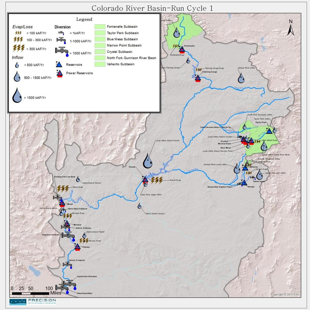
12 CBRFC Inflow Forecast Points Upper Basin Forecast Sites Fontenelle Reservoir Flaming Gorge Reservoir Yampa River Inflow Taylor Park Reservoir Blue Mesa Reservoir Morrow Point Reservoir Crystal Reservoir North Fork of the Gunnison Inflow Vallecito Reservoir Navajo Reservoir Animas River Inflow Lake Powell 12
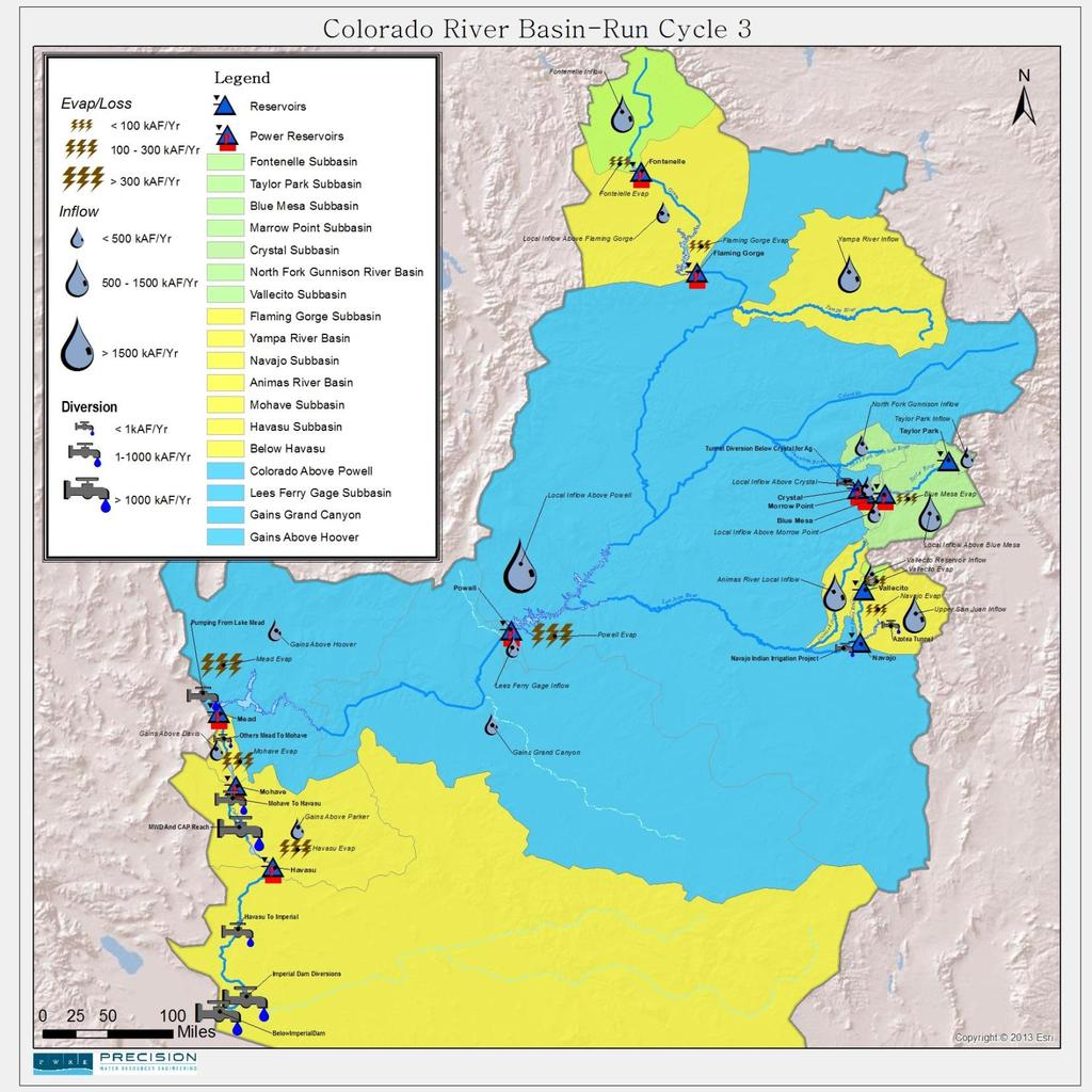
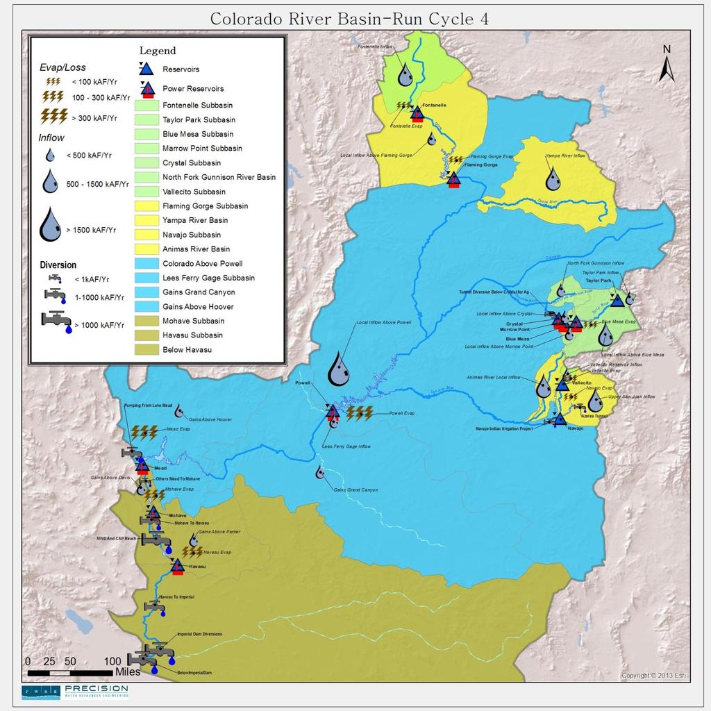
13 Within Each MRM Run Takes Advantage of Four Run Cycles - Each run cycle solves a different section of the basin (Upper Basin to the Lower Basin) - Allows for reservoirs to solve and allows to NOT have to forecast values within logic - Each Run Cycle starts at the beginning time step but allows for the previous Run Cycle data to be saved for use in the next 13
14
15
16
17
18 Output Each run will run a direct connect to excel DMI and send the appropriate data into a spreadsheet where output can be processed Allows for an easy interface between the model and excel for viewing and analysis of output from the MRM run 18

19 Output of Data 19

20 Output of Data 20

21 Probabilities of Powell Annual Releases 21

22 Next Steps Continue to validate the model Develop user manual and technical documentation Finalize process for distributing stakeholder report Develop more scenarios for more robust probabilistic analysis 22

23 Questions? 23
Colorado River Management under Uncertainty
 Colorado River Management under Uncertainty Terry Fulp Deputy Regional Director Lower Colorado Region WRRC Annual Meeting June 24, 2008 Colorado River Management under Uncertainty Overview of Colorado
Reclamation Perspective on Operational Snow Data and Needs. Snowpack Monitoring for Streamflow Forecasting and Drought Planning August 11, 2015
 Reclamation Perspective on Operational Snow Data and Needs Snowpack Monitoring for Streamflow Forecasting and Drought Planning August 11, 2015 2 Reclamation Operational Modeling 3 Colorado Basin-wide Models
NOAA s National Weather Service
 NOAA s National Weather Service Colorado Basin River Forecast Center Developing Climate-Informed Ensemble Streamflow Forecasts over the Colorado River Basin W. Paul Miller Colorado Basin River Forecast
DK DM M EMORANDUM D ECEMBER 28, 2018 SUBJECT:
 TO: CC: FROM: SUBJECT: BOARD OF DIRECTORS M EMORANDUM D ECEMBER 28, 2018 ANDY MUELLER, GENERAL MANAGER DAVE DK KANZER, P.E. & DON MEYER, P.E. DK DM COLORADO RIVER BASIN WATER SUPPLY CONDITIONS UPDATE AND
Managing Climate Risks on the Colorado River
 Managing Climate Risks on the Colorado River Balaji Rajagopalan Department of Civil, Environmental and Architectural Engineering & CIRES University of Colorado, Boulder, CO Symposium on Climate Risk Management
Sensitivity of Water Supply in the Colorado River Basin to Warming
 Sensitivity of Water Supply in the Colorado River Basin to Warming Greg McCabe U.S. Geological Survey, Denver, Colorado Dave Wolock U.S. Geological Survey, Lawrence, Kansas The Colorado River Basin Streamgage
Forecast Challenges for the Colorado Basin River Forecast Center
 Forecast Challenges for the Colorado Basin River Forecast Center John Lhotak, Development and Operations Hydrologist Improving Sub-Seasonal to Seasonal (S2S) Workshop May 16th, 2018 1 River Forecast Centers
Folsom Dam Water Control Manual Update
 Folsom Dam Water Control Manual Update Public Workshop April 3, 2014 Location: Sterling Hotel Ballroom 1300 H Street, Sacramento US Army Corps of Engineers BUILDING STRONG WELCOME & INTRODUCTIONS 2 BUILDING
Truckee River Operating Agreement (TROA) Operational Forecasting and Accounting Model
 Operational Forecasting and Accounting Model") Truckee River Operating Agreement (TROA) Operational Forecasting and Accounting Model 2015 February 3 rd, 2015 Boulder, CO Caleb Erkman, EIT Precision Water Resources Engineering www.precisionwre.com Collaboration
Truckee River Operating Agreement (TROA) Operational Forecasting and Accounting Model 2015 February 3 rd, 2015 Boulder, CO Caleb Erkman, EIT Precision Water Resources Engineering www.precisionwre.com Collaboration
Folsom Dam Water Control Manual Update Joint Federal Project, Folsom Dam
 Folsom Dam Water Control Manual Update Joint Federal Project, Folsom Dam Public Workshop May 28, 2015 Library Galleria 828 I Street, Sacramento, CA US Army Corps of Engineers BUILDING STRONG WELCOME &
FORECAST-BASED OPERATIONS AT FOLSOM DAM AND LAKE
 FORECAST-BASED OPERATIONS AT FOLSOM DAM AND LAKE 255 237 237 237 217 217 217 200 200 200 0 163 131 Bridging the Gap163Conference 255 0 132 255 0 163 122 The Dana on Mission Bay San Diego, CA January 28,
Weather Modification Activities in the Colorado River Basin. Mohammed Mahmoud
 Weather Modification Activities in the Colorado River Basin Mohammed Mahmoud Historical Information Authorized by 1968 Basin Project Act Substantially completed in 1993 Responsible for repaying reimbursable
-Assessment of current water conditions. - Precipitation Forecast. - Recommendations for Drought Monitor
 2 May 8 th, 2012 -Assessment of current water conditions - Precipitation Forecast - Recommendations for Drought Monitor AHPS Analysis 5/7/12 7-day average discharge compared to historical
-Assessment of current water conditions. - Precipitation Forecast. - Recommendations for Drought Monitor
 2 May 1 st, 2012 -Assessment of current water conditions - Precipitation Forecast - Recommendations for Drought Monitor AHPS Water Year Precipitation as Percentage of Normal 7-day average
NIDIS Intermountain West Drought Early Warning System April 18, 2017
 1 of 11 4/18/2017 3:42 PM Precipitation NIDIS Intermountain West Drought Early Warning System April 18, 2017 The images above use daily precipitation statistics from NWS COOP, CoCoRaHS, and CoAgMet stations.
The 21 st Century Colorado River Hot Drought and Implications for the Future
 Coauthor: Jonathan Overpeck The 21 st Century Colorado River Hot Drought and Implications for the Future CRWCD State of the River May 4, 2017 Brad Udall Colorado State University Bradley.udall@colostate.edu
The Drying of the Colorado River Basin: Lessons from the past 25 years applied to the next 25 years. Blue Mesa Reservoir
 The Drying of the Colorado River Basin: Lessons from the past 25 years applied to the next 25 years Upper Colorado River Basin Water Forum: Bridging Science, Policy & Practice Colorado Mesa University
-Assessment of current water conditions. - Precipitation Forecast. - Recommendations for Drought Monitor
 2 June 26 th, 2012 -Assessment of current water conditions - Precipitation Forecast - Recommendations for Drought Monitor CMPDSI Value Percentile Rank Characteristic -1.0 - -1.9 21-30 Abnormally
Management of Natural and Environmental Resources for Sustainable Agricultural Development
 World Meteorological Organization (WMO) Management of Natural and Environmental Resources for Sustainable Agricultural Development Use of the Object Modeling System for Operational Water Supply Forecasting
Grand Canyon Sediment Augmentation Study. Tim Randle, P.E. Manager, Sedimentation and River Hydraulics Group, Denver, Colorado
 Grand Canyon Sediment Augmentation Study Tim Randle, P.E. Manager, Sedimentation and River Hydraulics Group, Denver, Colorado Sediment Augmentation Objectives Seasonally increase turbidity to provide cover
NIDIS Intermountain West Drought Early Warning System March 26, 2019
 NIDIS Intermountain West Drought Early Warning System March 26, 2019 The images above use daily precipitation statistics from NWS COOP, CoCoRaHS, and CoAgMet stations. From top to bottom, and left to right:
Using Innovative Displays of Hydrologic Ensemble Traces
 Upper Colorado River Basin Water Forum November 7, 2018 Communicating Uncertainty and Risk in Water Resources: Using Innovative Displays of Hydrologic Ensemble Traces Richard Koehler, Ph.D. NOAA/NWS, Boulder,
A partnership with the Colorado Basin River Forecast Center: An experiment in Technology Transfer
 A partnership with the Colorado Basin River Forecast Center: An experiment in Technology Transfer Martyn P. Clark and Subhrendu Gangopadhyay Center for Science and Technology Policy Research David Brandon,
Kootenai Basin Water Supply Update and Sturgeon Flow Augmentation Kootenai Valley Resource Initiative
 Kootenai Basin Water Supply Update and Sturgeon Flow Augmentation Kootenai Valley Resource Initiative Greg Hoffman Fishery Biologist / Kootenai River Basin Flood Engineer Libby Dam 15 May 2017 US Army
-Assessment of current water conditions. - Precipitation Forecast. - Recommendations for Drought Monitor
 2 June 12, 2012 -Assessment of current water conditions - Precipitation Forecast - Recommendations for Drought Monitor 7-day average discharge compared to historical discharge for the day
Water Management for Environmental Restoration Flows In the Big Bend reach, Rio Grande Rio Bravo
 University of California, Davis Department of Land, Air and Water Resources Water Management for Environmental Restoration Flows In the Big Bend reach, Rio Grande Rio Bravo 46 th Annual Meeting 8 9 March,
NIDIS Intermountain West Regional Drought Early Warning System February 7, 2017
 NIDIS Drought and Water Assessment NIDIS Intermountain West Regional Drought Early Warning System February 7, 2017 Precipitation The images above use daily precipitation statistics from NWS COOP, CoCoRaHS,
A Review of the 2007 Water Year in Colorado
 A Review of the 2007 Water Year in Colorado Nolan Doesken Colorado Climate Center, CSU Mike Gillespie Snow Survey Division, USDA, NRCS Presented at the 28 th Annual AGU Hydrology Days, March 26, 2008,
NIDIS Intermountain West Drought Early Warning System December 11, 2018
 NIDIS Drought and Water Assessment NIDIS Intermountain West Drought Early Warning System December 11, 2018 Precipitation The images above use daily precipitation statistics from NWS COOP, CoCoRaHS, and
NIDIS Drought and Water Assessment
 7/23/13 1:57 PM PRECIPITATION The images above use daily precipitation statistics from NWS COOP, CoCoRaHS, and CoAgMet stations. From top to bottom, and left to right: most recent 7-days of accumulated
Operator and Modeler Collaboration on Truckee- Carson River Operations Using Ensembles River Ware User Group Meeting Thursday February 1, 2018
 Operator and Modeler Collaboration on Truckee- Carson River Operations Using Ensembles River Ware User Group Meeting Thursday February 1, 2018 Caleb Erkman, P.E. PWRE David Wathen Deputy TROA Administrator
BUREAU OF METEOROLOGY
 BUREAU OF METEOROLOGY Building an Operational National Seasonal Streamflow Forecasting Service for Australia progress to-date and future plans Dr Narendra Kumar Tuteja Manager Extended Hydrological Prediction
Folsom Dam Water Control Manual Update Joint Federal Project, Folsom Dam
 Folsom Dam Water Control Manual Update Joint Federal Project, Folsom Dam Public Workshop May 25, 2016 Sacramento Library Galleria 828 I Street, Sacramento, CA US Army Corps of Engineers BUILDING STRONG
COLORADO WATER SUPPLY CONDITIONS UPDATE
 COLORADO WATER SUPPLY CONDITIONS UPDATE FROM THE OFFICE OF THE STATE ENGINEER: COLORADO DIVISION OF WATER RESOURCES January 215 ROOM 818, 1313 SHERMAN ST., DENVER, CO 823 33-866-3581; www.water.state.co.us
PRECIPITATION. Last Week Precipitation:
 12/3/2014 NIDIS Drought and Water Assessment PRECIPITATION The images above use daily precipitation statistics from NWS COOP, CoCoRaHS, and CoAgMet stations. From top to bottom, and left to right: most
Elevation (ft) 50th to 75th Percentile 25th to 50th Percentile Median Observed /1 11/1 12/1 1/1 2/1 3/1 4/1 5/1 6/1 7/1 8/1 9/1 Date
 50th to 75th Percentile 25th to 50th Percentile Median Observed /1 11/1 12/1 1/1 2/1 3/1 4/1 5/1 6/1 7/1 8/1 9/1 Date") Elevation (ft) 2470 2460 2450 2440 2430 2420 2410 2400 2390 2380 2370 2360 2350 2340 2330 2320 2310 2300 2290 2280 2270 2260 2250 2240 2230 2220 Bars Indicate 5th and 95th percentiles Lake Koocanusa Elevation
Elevation (ft) 2470 2460 2450 2440 2430 2420 2410 2400 2390 2380 2370 2360 2350 2340 2330 2320 2310 2300 2290 2280 2270 2260 2250 2240 2230 2220 Bars Indicate 5th and 95th percentiles Lake Koocanusa Elevation
March 1, 2003 Western Snowpack Conditions and Water Supply Forecasts
 Natural Resources Conservation Service National Water and Climate Center 101 SW Main Street, Suite 1600 Portland, OR 97204-3224 Date: March 17, 2003 Subject: March 1, 2003 Western Snowpack Conditions and
NOAA Water Resources Monitor and Outlook
 NOAA Water Resources Monitor and Outlook 1 Andrea J. Ray, NOAA/ESRL Physical Sciences Division, Michelle Stokes, NOAA Colorado Basin River Forecast Center, and the WRMO steering team: Robert Hartman -
Guide to Hydrologic Information on the Web
 NOAA s National Weather Service Guide to Hydrologic Information on the Web Colorado River at Lees Ferry Photo: courtesy Tim Helble Your gateway to web resources provided through NOAA s Advanced Hydrologic
Upper Colorado River Basin Flows and Paleohydrology Jenny Ta
 Upper Colorado River Basin Flows and Paleohydrology Jenny Ta Introduction The Colorado River flows from its headwaters in the Rocky Mountains, through seven U.S. and two Mexican states into the Colorado
NIDIS Weekly Climate, Water and Drought Assessment Summary. Upper Colorado River Basin May 29, 2012
 NIDIS Weekly Climate, Water and Drought Assessment Summary Upper Colorado River Basin May 29, 2012 PrecipitaFon and Snowpack Fig. 1: May 1 19 precipitafon in inches. Fig. 2: May 20 27 precipitafon in inches.
-Assessment of current water conditions. - Precipitation Forecast. - Recommendations for Drought Monitor
 June 1, 2010 -Assessment of current water conditions - Precipitation Forecast - Recommendations for Drought Monitor Snotel WYTD Precipitation as Percentage of Average Upper Colorado Headwaters 88% of
NIDIS Weekly Climate, Water and Drought Assessment Summary. Upper Colorado River Basin June 26, 2012
 NIDIS Weekly Climate, Water and Drought Assessment Summary Upper Colorado River Basin June 26, 2012 Fig. 1: June 17 23 precipitafon in inches. Fig. 2: SNOTEL WYTD precipitafon percenfles (50% is median,
Precipitation. Standardized Precipitation Index. NIDIS Intermountain West Regional Drought Early Warning System December 6, 2016
 12/9/2016 NIDIS Drought and Water Assessment NIDIS Intermountain West Regional Drought Early Warning System December 6, 2016 Precipitation The images above use daily precipitation statistics from NWS COOP,
NIDIS Intermountain West Drought Early Warning System October 30, 2018
 10/30/2018 NIDIS Drought and Water Assessment NIDIS Intermountain West Drought Early Warning System October 30, 2018 Precipitation The images above use daily precipitation statistics from NWS COOP, CoCoRaHS,
COLORADO WATER SUPPLY CONDITIONS UPDATE
 COLORADO WATER SUPPLY CONDITIONS UPDATE FROM THE OFFICE OF THE STATE ENGINEER: COLORADO DIVISION OF WATER RESOURCES December 211 ROOM 818, 1313 SHERMAN ST., DENVER, CO 823 33-866-3581; www.water.state.co.us
The Colorado Drought : 2003: A Growing Concern. Roger Pielke, Sr. Colorado Climate Center.
 The Colorado Drought 2001-2003: 2003: A Growing Concern Roger Pielke, Sr. Colorado Climate Center Prepared by Tara Green and Odie Bliss http://climate.atmos.colostate.edu 2 2002 Drought History in Colorado
FY 2002 ANNUAL PROJECT REPORT PROJECT NUMBER: 107. I. Project Title: Gunnison River / Aspinall Unit Temperature Model: Phase II
 COLORADO RIVER RECOVERY PROGRAM RECOVERY PROGRAM FY 2002 ANNUAL PROJECT REPORT PROJECT NUMBER: 107 I. Project Title: Gunnison River / Aspinall Unit Temperature Model: Phase II II. Principal Investigators:
P1.8 INTEGRATING ASSESSMENTS OF USER NEEDS WITH WEATHER RESEARCH: DEVELOPING USER-CENTRIC TOOLS FOR RESERVOIR MANAGEMENT
 P1.8 INTEGRATING ASSESSMENTS OF USER NEEDS WITH WEATHER RESEARCH: DEVELOPING USER-CENTRIC TOOLS FOR RESERVOIR MANAGEMENT Andrea J. Ray 1, Joseph J. Barsugli 1,2, and Thomas Hamill 1 1 NOAA Earth Systems
NIDIS Intermountain West Drought Early Warning System September 4, 2018
 NIDIS Drought and Water Assessment NIDIS Intermountain West Drought Early Warning System September 4, 2018 Precipitation The images above use daily precipitation statistics from NWS COOP, CoCoRaHS, and
NIDIS Weekly Climate, Water and Drought Assessment Summary. Upper Colorado River Basin July 31, 2012
 NIDIS Weekly Climate, Water and Drought Assessment Summary Upper Colorado River Basin July 31, 2012 Fig. 1: July month-to-date precipitation in inches. Fig. 2: SNOTEL WYTD precipitation percentiles (50%
NIDIS Drought and Water Assessment
 NIDIS Drought and Water Assessment PRECIPITATION The images above use daily precipitation statistics from NWS COOP, CoCoRaHS, and CoAgMet stations. From top to bottom, and left to right: most recent 7-days
National Weather Service. Harold H. Opitz Hydrologist in Charge
 National Weather Service Harold H. Opitz Hydrologist in Charge Goals Organization Role of the River Forecast Center Describe Forecast System & Tools Other Details NWS River Forecast Centers Northwest River
Summary of SARP Kickoff Workshop 10/1/ /2/2012
 Summary of SARP Kickoff Workshop 10/1/2012-10/2/2012 On October 1 st a kickoff meeting for the Integrating Climate Forecasts and Reforecasts into Decision Making SARP project was held in Salt Lake City
-Assessment of current water conditions. - Precipitation Forecast. - Recommendations for Drought Monitor
 May 31 st, 2011 -Assessment of current water conditions - Precipitation Forecast - Recommendations for Drought Monitor Upper Colorado River Basin Snow Snowpack % of average to date: 347% Percent
The data presented in this graph are provisional and are intended to provide an estimate of Libby Dam forebay elevation (Lake Koocanusa).
.") Elevation (ft) 2470 2460 2450 2440 2430 2420 2410 2400 2390 2380 2370 2360 2350 2340 2330 2320 2310 2300 2290 Lake Koocanusa Elevation - Probability Chart 2280 2270 The data presented in this graph are
Elevation (ft) 2470 2460 2450 2440 2430 2420 2410 2400 2390 2380 2370 2360 2350 2340 2330 2320 2310 2300 2290 Lake Koocanusa Elevation - Probability Chart 2280 2270 The data presented in this graph are
Filling Gaps in Water Supply Predictions: The RIO-SNO-FLOW Project
 Filling Gaps in Water Supply Predictions: The RIO-SNO-FLOW Project Project Team: Colorado Water Conservation Board NOAA National Severe Storms Laboratory (NSSL) National Center for Atmospheric Research
HyMet Company. Streamflow and Energy Generation Forecasting Model Columbia River Basin
 HyMet Company Streamflow and Energy Generation Forecasting Model Columbia River Basin HyMet Inc. Courthouse Square 19001 Vashon Hwy SW Suite 201 Vashon Island, WA 98070 Phone: 206-463-1610 Columbia River
P1.8 INTEGRATING ASSESSMENTS OF USER NEEDS WITH WEATHER RESEARCH: DEVELOPING USER-CENTRIC TOOLS FOR RESERVOIR MANAGEMENT
 P1.8 INTEGRATING ASSESSMENTS OF USER NEEDS WITH WEATHER RESEARCH: DEVELOPING USER-CENTRIC TOOLS FOR RESERVOIR MANAGEMENT Andrea J. Ray 1, Joseph J. Barsugli 1,2, and Thomas Hamill 1 1 NOAA Earth Systems
Elevation (ft) 50th to 75th Percentile 25th to 50th Percentile Median Observed
 50th to 75th Percentile 25th to 50th Percentile Median Observed") 2470 Lake Koocanusa Elevation - Probability Chart Elevation (ft) 2460 2450 2440 2430 2420 2410 2400 2390 2380 2370 2360 2350 2340 2330 2320 2310 2300 The data presented in this graph are provisional and
2470 Lake Koocanusa Elevation - Probability Chart Elevation (ft) 2460 2450 2440 2430 2420 2410 2400 2390 2380 2370 2360 2350 2340 2330 2320 2310 2300 The data presented in this graph are provisional and
NIDIS Intermountain West Drought Early Warning System October 17, 2017
 NIDIS Drought and Water Assessment NIDIS Intermountain West Drought Early Warning System October 17, 2017 Precipitation The images above use daily precipitation statistics from NWS COOP, CoCoRaHS, and
Hydrogeology and Simulated Effects of Future Water Use and Drought in the North Fork Red River Alluvial Aquifer: Progress Report
 Hydrogeology and Simulated Effects of Future Water Use and Drought in the North Fork Red River Alluvial Aquifer: Progress Report Developed in partnership with the Oklahoma Water Resources Board S. Jerrod
PRECIPITATION. Last Week Precipitation:
 2/24/2015 NIDIS Drought and Water Assessment PRECIPITATION The images above use daily precipitation statistics from NWS COOP, CoCoRaHS, and CoAgMet stations. From top to bottom, and left to right: most
Key Findings & Implications
 A Tree-Ring Based Assessment of Synchronous Extreme Streamflow Episodes in the Upper Colorado & Salt-Verde-Tonto River Basins Key Findings & Implications August 10, 2005 Workshop A Collaborative Project
 Water Supply Forecast - THE DALLES http://www.nwrfc.noaa.gov/water_supply/ws_forecasts.php?id=tdao3 Page 1 of 1 3/7/2013 Close Archive Data/Normals Rankings Adjustments Verification Verify All Years Help
FINAL Report for COMET proposal entitled:
 FINAL Report for COMET proposal entitled: Development of an Automatic Calibration Scheme for Colorado River Basin Forecasts UCAR Award No. S04-44691 September, 2005 Terri S. Hogue, Assistant Professor,
Intermountain West Climate Summary
 Intermountain West Climate Summary by The Western Water Assessment Hydrological Conditions Drought is expected to persist over Utah, western Colorado, and western Wyoming, but there has been some decrease
NIDIS Weekly Climate, Water and Drought Assessment Summary. Upper Colorado River Basin June 28, 2011
 NIDIS Weekly Climate, Water and Drought Assessment Summary Upper Colorado River Basin June 28, 2011 PrecipitaFon and Snowpack Fig. 1: June month to date precipitafon in inches. Fig. 2: June 19 25 precipitafon
Using a high-resolution ensemble modeling method to inform risk-based decision-making at Taylor Park Dam, Colorado
 Using a high-resolution ensemble modeling method to inform risk-based decision-making at Taylor Park Dam, Colorado Michael J. Mueller 1, Kelly Mahoney 2, Kathleen Holman 3, David Gochis 4 1 Cooperative
Integrating Weather Forecasts into Folsom Reservoir Operations
 Integrating Weather Forecasts into Folsom Reservoir Operations California Extreme Precipitation Symposium September 6, 2016 Brad Moore, PE US Army Corps of Engineers Biography Brad Moore is a Lead Civil
WSWC/NOAA Workshops on S2S Precipitation Forecasting
 WSWC/NOAA Workshops on S2S Precipitation Forecasting San Diego, May 2015 Salt Lake City at NWS Western Region HQ, October 2015 Las Vegas at Colorado River Water Users Association, December 2015 College
PERCENT BIAS ASSESSMENT OF WATER-SUPPLY OUTLOOKS IN THE COLORADO RIVER BASIN. Brent Harrison 1 and Roger Bales 2 ABSTRACT INTRODUCTION
 PERCENT BIAS ASSESSMENT OF WATER-SUPPLY OUTLOOKS IN THE COLORADO RIVER BASIN Brent Harrison 1 and Roger Bales 2 ABSTRACT Water-supply forecasts on various watersheds are intended to predict the April through
NIDIS Intermountain West Drought Early Warning System November 13, 2018
 NIDIS Intermountain West Drought Early Warning System November 13, 2018 Precipitation The images above use daily precipitation statistics from NWS COOP, CoCoRaHS, and CoAgMet stations. From top to bottom,
THE STATE OF SURFACE WATER GAUGING IN THE NAVAJO NATION
 THE STATE OF SURFACE WATER GAUGING IN THE NAVAJO NATION Aregai Tecle Professor of Hydrology Northern Arizona University Flagstaff, AZ Acknowledgement Many thanks to my research team mates and Elisabeth
NIDIS Weekly Climate, Water and Drought Assessment Summary. Upper Colorado River Basin May 31, 2011
 NIDIS Weekly Climate, Water and Drought Assessment Summary Upper Colorado River Basin May 31, 2011 PrecipitaFon and Snowpack Fig. 1: May month to date precipitafon in inches. Fig. 2: May 22 28 precipitafon
NIDIS Intermountain West Drought Early Warning System July 18, 2017
 NIDIS Drought and Water Assessment NIDIS Intermountain West Drought Early Warning System July 18, 2017 Precipitation The images above use daily precipitation statistics from NWS COOP, CoCoRaHS, and CoAgMet
NIDIS Weekly Climate, Water and Drought Assessment Summary. Upper Colorado River Basin January 3, 2012
 NIDIS Weekly Climate, Water and Drought Assessment Summary Upper Colorado River Basin January 3, 2012 PrecipitaFon and Snowpack Fig. 1: December precipitafon as a percent of average. Fig. 2: December 25
Webinar and Weekly Summary February 15th, 2011
 Webinar and Weekly Summary February 15th, 2011 -Assessment of current water conditions - Precipitation Forecast - Recommendations for Drought Monitor Upper Colorado Normal Precipitation Upper Colorado
Napa Valley Groundwater Sustainability: A Basin Analysis Report for the Napa Valley Subbasin
 Napa Valley Groundwater Sustainability: A Basin Analysis Report for the Napa Valley Subbasin December 13, 2016 Napa County Board of Supervisors By Vicki Kretsinger Grabert and Reid Bryson Basin Analysis
Wyoming Pre-Workshop Survey Results August 27, 2015 Lander Wyoming
 Wyoming Pre-Workshop Survey Results August 27, 2015 Lander Wyoming WHAT AREA(S) DO YOU WORK IN?! PLANNING, MGT, OPS! DROUGHT! RESEARCH! PUBLIC LANDS MGT! AG OR RANCHING! RECREATION! ENERGY! 0! 3.5! 7!
AN OVERVIEW OF ENSEMBLE STREAMFLOW PREDICTION STUDIES IN KOREA
 AN OVERVIEW OF ENSEMBLE STREAMFLOW PREDICTION STUDIES IN KOREA DAE-IL JEONG, YOUNG-OH KIM School of Civil, Urban & Geosystems Engineering, Seoul National University, San 56-1, Sillim-dong, Gwanak-gu, Seoul,
9. PROBABLE MAXIMUM PRECIPITATION AND PROBABLE MAXIMUM FLOOD
 9. PROBABLE MAXIMUM PRECIPITATION AND PROBABLE MAXIMUM FLOOD 9.1. Introduction Due to the size of Watana Dam and the economic importance of the Project to the Railbelt, the Probable Maximum Flood (PMF)
Optimal Artificial Neural Network Modeling of Sedimentation yield and Runoff in high flow season of Indus River at Besham Qila for Terbela Dam
 Optimal Artificial Neural Network Modeling of Sedimentation yield and Runoff in high flow season of Indus River at Besham Qila for Terbela Dam Akif Rahim 1, Amina Akif 2 1 Ph.D Scholar in Center of integrated
PRECIPITATION. Last Week Precipitation:
 PRECIPITATION The images above use daily precipitation statistics from NWS COOP, CoCoRaHS, and CoAgMet stations. From top to bottom, and left to right: most recent 7-days of accumulated precipitation in
Update on Seasonal Conditions & Summer Weather Outlook
 Update on Seasonal Conditions & Summer Weather Outlook Andy Bryant National Weather Service Portland, Oregon June 6, 2018 Overview Quick review of winter and spring conditions Seasonal water supply forecasts
GUNNISON RIVER / ASPINALL UNIT TEMPERATURE STUDY - PHASE II
 GUNNISON RIVER / ASPINALL UNIT TEMPERATURE STUDY - PHASE II FINAL REPORT PREPARED FOR: UPPER COLORADO RIVER ENDANGERED FISH RECOVERY PROGRAM PROJECT # 17 (USBR CONTRACT # 1-FC-4-534) JANUARY 24 Jean Marie
NIDIS Intermountain West Drought Early Warning System April 16, 2019
 NIDIS Intermountain West Drought Early Warning System April 16, 2019 Precipitation The images above use daily precipitation statistics from NWS COOP, CoCoRaHS, and CoAgMet stations. From top to bottom,
NIDIS Intermountain West Drought Early Warning System November 14, 2017
 NIDIS Intermountain West Drought Early Warning System November 14, 2017 Precipitation The images above use daily precipitation statistics from NWS COOP, CoCoRaHS, and CoAgMet stations. From top to bottom,
RED RIVER PERIOD OF RECORD UPDATE THRU 2017 FOR USACE- SWD
 RED RIVER PERIOD OF RECORD UPDATE THRU 2017 FOR USACE- SWD Sarah Harris Corps of Engineers, Tulsa District 2018 RW Users Meeting Contributors: Mary Ann Duke, USACE-Tulsa District US Army Corps of Engineers
Geo/SAT 2 DROUGHT IN THE COLORADO RIVER BASIN: SHRINKAGE OF LAKE POWELL
 Geo/SAT 2 DROUGHT IN THE COLORADO RIVER BASIN: SHRINKAGE OF LAKE POWELL Professor Paul R. Baumann Department of Geography State University of New York College at Oneonta Oneonta, New York 13820 USA COPYRIGHT
NIDIS Intermountain West Drought Early Warning System January 22, 2019
 NIDIS Drought and Water Assessment NIDIS Intermountain West Drought Early Warning System January 22, 2019 Precipitation The images above use daily precipitation statistics from NWS COOP, CoCoRaHS, and
NIDIS Intermountain West Drought Early Warning System February 19, 2019
 NIDIS Intermountain West Drought Early Warning System February 19, 2019 Precipitation The images above use daily precipitation statistics from NWS COOP, CoCoRaHS, and CoAgMet stations. From top to bottom,
NATIONAL WATER RESOURCES OUTLOOK
 NATIONAL WATER RESOURCES OUTLOOK American Meteorological Society Annual Meeting 24 th Hydrology Conference 9.2 James Noel Service Coordination Hydrologist National Weather Service-Ohio River Forecast Center
Comprehensive Review of the Fill Lake Mead First Initiative
 Comprehensive Review of the Fill Lake Mead First Initiative 1. INTRODUCTION Trevor Carey ECL 290 The Colorado River Basin (CRB) has a diverse set of stakeholders that shape basin policy. The management
NIDIS Weekly Climate, Water and Drought Assessment Summary. Upper Colorado River Basin February 12, 2013
 NIDIS Weekly Climate, Water and Drought Assessment Summary Upper Colorado River Basin February 12, 2013 Fig. 1: January precipitagon as a percent of average. Fig. 2: February 1 9 precipitagon in inches.
Westmap: The Western Climate Mapping Initiative An Update
 Westmap: The Western Climate Mapping Initiative An Update Andrew Comrie 1, Kelly Redmond 2, Mary Glueck 1, Hauss Reinbold 3, Chris Daly 4 1 University of Arizona, 2 DRI / Western Regional Climate Center
FINAL TECHNICAL MEMORANDUM
 January 2, 2001 Page 1 FINAL TECHNICAL MEMORANDUM SUBJECT: PREPARED BY: Green River Basin Plan Surface Water Data Synthesis and Spreadsheet Model Development Meg Frantz and Linda Williams, Boyle Engineering
Utah Climate and Water Report
 Utah State University DigitalCommons@USU Water U.S. Government Documents (Utah Regional Depository) 2010 Utah Climate and Water Report U.S. Natural Resources Conservation Service Follow this and additional
Merced Irrigation District Hydrologic and Hydraulic Operations (MIDH2O) Model
 Model") Merced Irrigation District Hydrologic and Hydraulic Operations (MIDH2O) Model September 05, 2018 Marco Bell, Merced Irrigation District Bibek Joshi, Dewberry Objective Introduce HEC-RTS Benefits of MIDH2O
Merced Irrigation District Hydrologic and Hydraulic Operations (MIDH2O) Model September 05, 2018 Marco Bell, Merced Irrigation District Bibek Joshi, Dewberry Objective Introduce HEC-RTS Benefits of MIDH2O
Precipitation. Standardized Precipitation Index. NIDIS Intermountain West Drought Early Warning System September 5, 2017
 9/6/2017 NIDIS Drought and Water Assessment NIDIS Intermountain West Drought Early Warning System September 5, 2017 Precipitation The images above use daily precipitation statistics from NWS COOP, CoCoRaHS,