Wind Atlas for South Africa (WASA)
|
|
|
- Tamsin Booker
- 5 years ago
- Views:
Transcription
 Andre Otto (SANEDI),")
 7 November")
1 Wind Atlas for South Africa (WASA) Andre Otto (SANEDI), Jens Carsten Hansen (DTU Wind Energy) 7 November 2014
2 Outline Why Wind Resource Assessment Historical South African Wind Atlases Wind Atlas for South Africa (WASA) Project WASA method Wind Measurements for Verification Verified Numerical Wind Atlas WRF Time Series Time Series Application High Resolution Wind Resource Map High Resolution Wind Resource Map Application Extreme Wind Atlas Extreme Wind Atlas Application WASA User Statistics Conclusion
 concluded: These studies are")

3 Historical South African Wind Atlases DME; R. Diab 1995 SARERD, 2001 Tripod Review of Wind Energy Resources in South Africa (2002) concluded: These studies are inconclusive and under estimate the true wind energy potential as weather measurement stations at 10 m were used and in may cases these stations are shaded by buildings etc from measuring the true wind potential; and Recommended that a dedicated wind energy measurement program be undertaken to confirm South Africa s true wind energy potential
 Renewable Energy IPP Procurement Programme 3.725 GW of which 1.85 GW wind, 1.45 GW PV, 0.")
4 Why Wind Resource assessment? Wind energy contributes a significant share of the IRP 2010 and REBID IRP 2010 to 2030, 42%, 17.8 GW of which 20%, 8.4 GW wind new build to come from renewable energy (8.4 GW PV, 1 GW CSP) Renewable Energy IPP Procurement Programme GW of which 1.85 GW wind, 1.45 GW PV, 0.2 GW CSP IRP 2010 is a living document Energy in wind P = ½ U 3 [W/ m 2 ] GHC mitigation tons CO2/MW (20 year lifetime, 0.27 capacity factor) Water savings of 229 l/mwh (compared to coal fired power stations) Wind speed U [m/s] New industry, job creation Wind provides the income Wind measurements are in one point in space Wind varies significantly across the terrain Spatial distribution needed for planning and projects Accuracy is essential (ΔU of 5% ΔP of 15%) Modelling is necessary and challenging
5 Wind Atlas for South Africa (WASA) : The Wind Atlas for South Africa (WASA) project ( ) is a Capacity Development and Research Cooperation Initiative of the South African Department of Energy (DoE). Principal funders are: the Royal Danish Embassy DKK 9,998,441 and Global Environmental Facility (GEF) R8 million through the South African Wind Energy Programme (SAWEP). SANEDI (South African National Energy Development Institute) executing agency contracting the implementing partners coordination and dissemination UCT CSAG (Climate System Analysis Group, University of Cape Town) mesoscale modelling CSIR (Built Environment, Council for Scientific and Industrial Research) Measurements, microscale modelling, application SAWS (South African Weather Service) extreme wind assessment DTU Wind Energy* (Dept of Wind Energy, Technical University of Denmark) partner in all activities


6 WASA Method Global Measurements wind farm G Mesoscale modeling Regional wind climate Microscale modeling Local wind Global wind resources Presentations and links to information are available at the SANERI web site :


7 Wind Measurements for Verification 10 minutes data and graphs available online: Cannot manage what you cannot measure Data download: U 61.9 m U 61.9 m WASA - 1 YEAR - 3 YEARS* U Data recovery [m/s] [m/s] [%] [%] WM WM WM WM WM WM WM WM WM09* WM10* U mean mean wind speed * 2-year periods for WM09 and WM10: WM09: to minus the year WM10: to plus to x 60m masts Date must be accurate, representative >1 year, > 90% data recovery, reliable IEC and Measnet Wind Measurement Standards Quality Assurance checked
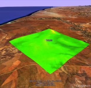
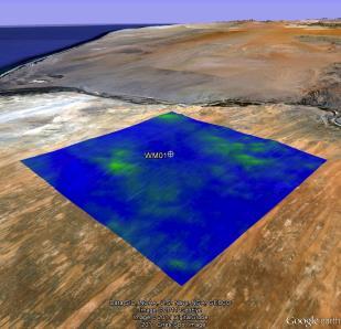
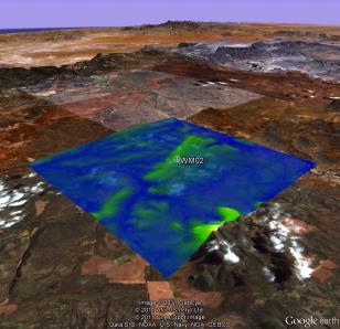
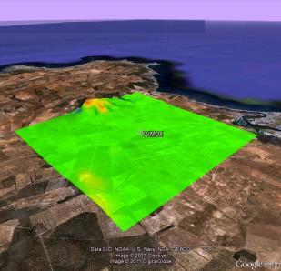
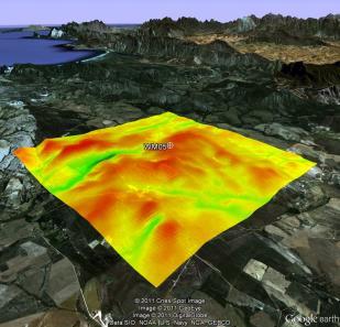

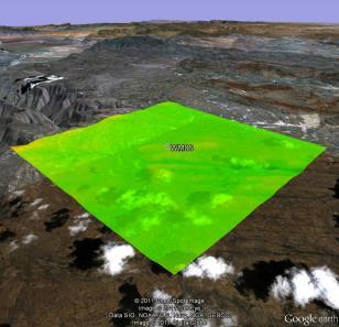
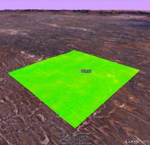
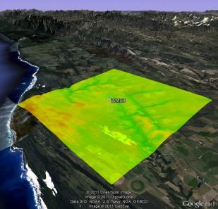
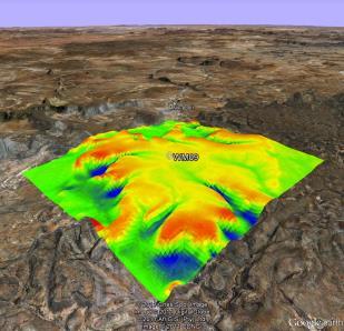
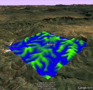
8 Observational Wind Atlas WM01 WM02 WM03 WM04 WM05 WM06 WM07 WM Wind speed at 80 m above ground level WM09 WM10 WAsP resource grids from Observational Wind Atlas 10 x 10 km 2 grid 100 meter grid spacing

9 Numerical Wind Atlas

10 Numerical Wind Atlas cont.

11 Numerical Wind Atlas cont.

12 Numerical Wind Atlas cont.
13 New research wind atlas: WRF Model Configuration Very large (309 x 435) inner grid (3km grid spacing) Changes to standard WRF land use and roughness ERA-Interim forcing, 1/12 degree SSTs; MYJ PBL; 41 vertical levels (further details in meso report) Simulations: 8 years for (27/9/3 km) ; Highresolution SSTs; 24 years (27/9 km) ; 11/7/


14 Weather, Research and Forecast (WRF) model Complex model with many options that need to chosen by the user Mesoscale & Microscale Meteorology Division / NCAR Best configuration not found by chance: Extensive set of year-long simulations were performed to optimize domain size and location and various parameterizations /7/201 4
 and the new MODIS climatology (2001-2012) MODIS satellite-derived land cover 11/7/2014")
15 Difference in MODIS Landcover Difference in land cover classes between what is currently used in WRF (1 year) and the new MODIS climatology ( ) MODIS satellite-derived land cover 11/7/

 WRF (new)")
16 Numerical wind atlases WRF vs KAMM Generalized wind speed, h=100 m, z0=0.03 m KAMM (old) WRF (new) 11/7/2014 EWEA, Barcelona,
17 Validation: Example: WASA site 1, far northwest Observed wind atlas Weighted (solid) Re-fit (dashed) Numerical wind atlas KAMM Numerical wind atlas WRF 11/7/
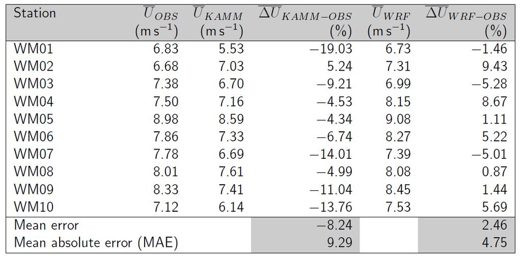
18 Validation summary

19 Example: Seasonal and diurnal cycles in the observations and the WRF simulations Chris Lennard and Brendan Argent 11/7/2014 WASA Final Univ. Cape Town Wind Seminar 19

20 Summary: Seasonal and diurnal cycles in the observations and the WRF simulations
 D2, 9 km x 9 km, hourly, Jan 1990 - Sep 2013 (could be extended to 2014) D3 (WASA 1 domain), 3 km x 3 km, hourly and 10-minutes (only winds), Oct 2005 - Sep 2013")
21 WRF Time series D1 D2 D3 Available WASA time series: D1 (covers all South Africa), 27 km x 27 km, 3-hourly, Oct Sep 2013 (could be rerun for with hourly output) D2, 9 km x 9 km, hourly, Jan Sep 2013 (could be extended to 2014) D3 (WASA 1 domain), 3 km x 3 km, hourly and 10-minutes (only winds), Oct Sep 2013
22 Time Series Application Study the annual, seasonal and diurnal variations in wind resources As input to power system modelling Study the geographical cross correlation of wind across South Africa Used for long-term correction of the wind resources given by the WRF wind climate files ( lib files)
23 NWA Summary and conclusions Results from a new verified numerical wind atlas for South Africa are presented and compared to the first verified wind atlas Production of the new wind atlas required a large amount of work many knowledge and software was not available at the inset of the project KAMM/WAsP method, numerically very cheap, gives good results underestimation of mean wind speed at most sites; specially at sites influenced by thermal processes resulted in a quite conservative wind resource atlas WRF method, numerically very expensive, gives excellent results Excellent comparison between wind roses in model and observations Stability conditions should be taken into account at generalization 11/7/

24 Microscale vs Mesoscale: effect of resolution

25 Available input data for detailed Verified Numerical Wind Atlas resource mapping WRF mesoscale model, 3 km Elevation 100-m elevation grids from Space Shuttle Topography Mission, SRTM version 3. Land cover and roughness USGS Global Land Cover Characteristics database. Transformation table for z 0 WASA Final Wind Seminar 25 8 April 2014

26 High Resolution Wind Resource Map Large Scale High Resolution Wind Resource map WRF based (local wind climate, 250 m resolution, April 2014)
27 High Resolution Wind Resource Map Application The High Resolution Wind Resource Map depicts the local wind climate that a wind turbine would encounter and offers the following important benefits for developers, policy makers, utilities and industry: Cost and timing savings as the bankability of a potential wind farm site can be estimated with known and traceable accuracy*; Levels the playing field between small or large industry players to identify and develop project sites for wind farms*; Assists the South African Government in estimating the potential yield of the wind energy resources; Identification of potential wind development zones in line with the strategic environmental framework or assessments (SEA) studies (e.g. Dept Environmental Affairs SEA for Solar PV and Wind Long-term grid planning. *Physical wind measurements are still required by financiers to confirm the bankability of a wind farm project at the identifiedsite(s).

28 Extreme Wind Atlas 1:50 yr 10 min wind speed 10 m above ground level (standard conditions)
29 Extreme Wind Atlas Application Wind constitutes most critical environmental loading affecting structural design of built environment in South Africa and information on extreme winds is also essential in the design of wind farms situated in areas with relatively strong winds. Providing input data (1:50 yr 10 min average wind speed (standard conditions) in calculating the 10 minute average wind speed at hub height which is a parameter in determining the appropriate Wind Turbine Class (IEC turbine classification scheme)

30 WASA User Statistics (May 2014) registered users 60 - countries downloads All users by Affiliation-type 20 - Non-SA Governmental/Provincial/Municipal Agencies 21 - Non-SA Non-Profit Non-SA Private Companies 79 - Non-SA Universities and Schools 12 - Non-SA Other SA Government/Provincial/Municipal Agencies 65 - SA Non-Profit SA Private Companies SA Universities and Schools 40 - SA Other IRENA Global Atlas World Bank ESMAP

31 Conclusion State of the Art Wind Atlas method Public domain through websites Transparent methodology no black box Verified with proper wind measurements, traceable Data + Application, Guidelines, Training Level playing field Save time and money Not a substitution for mandatory wind measurements South Africa has an excellent wind resource that compares with the best in the world.
32 SAWEA and its members have argued and measured for many years that there is a significant wind resource in South Africa, enough to support a significant sized Wind Energy industry. This view has now been validated by the independent WASA team, consisting of DoE, SANEDI, CSIR, SAWS, UCT and DTU, through the latest developments in the Wind Atlas. SAWEA would also like to congratulate the WASA team on further developing an internationally recognised methodology for compiling such a wind map that is already being adopted by other countries Frank Spencer - On behalf of SAWEA Technical Working Group
33 WASA Websites (information, presentations etc) (wind measurement mast online graphs) (final reports, data downloads) WRF (WRF wind forecasting) Numerical Wind Atlas database access through Tadpole (Google Earth)


34 Thank you Andre Otto Jens Carsten Hansen SANEDI DTU Wind Energy +27 (0)
WASA WP1:Mesoscale modeling UCT (CSAG) & DTU Wind Energy Oct March 2014
 & DTU Wind Energy Oct March 2014") WASA WP1:Mesoscale modeling UCT (CSAG) & DTU Wind Energy Oct 2013 - March 2014 Chris Lennard and Brendan Argent University of Cape Town, Cape Town, South Africa Andrea N. Hahmann (ahah@dtu.dk), Jake Badger,
WASA WP1:Mesoscale modeling UCT (CSAG) & DTU Wind Energy Oct 2013 - March 2014 Chris Lennard and Brendan Argent University of Cape Town, Cape Town, South Africa Andrea N. Hahmann (ahah@dtu.dk), Jake Badger,
WASA Project Team. 13 March 2012, Cape Town, South Africa
 Overview of Wind Atlas for South Africa (WASA) project WASA Project Team 13 March 2012, Cape Town, South Africa Outline The WASA Project Team The First Verified Numerical Wind Atlas for South Africa The
Validation and comparison of numerical wind atlas methods: the South African example
 Downloaded from orbit.dtu.dk on: Jul 18, 2018 Validation and comparison of numerical wind atlas methods: the South African example Hahmann, Andrea N.; Badger, Jake; Volker, Patrick; Nielsen, Joakim Refslund;
Why WASA an introduction to the wind atlas method and some applications
 Why WASA an introduction to the wind atlas method and some applications Jens Carsten Hansen and Niels G. Mortensen DTU Wind Energy (Dept of Wind Energy, Technical University of Denmark) Eugene Mabille,
What is a wind atlas and where does it fit into the wind energy sector?
 What is a wind atlas and where does it fit into the wind energy sector? DTU Wind Energy By Hans E. Jørgensen Head of section : Meteorology & Remote sensing Program manager : Siting & Integration Outline
A comparative and quantitative assessment of South Africa's wind resource the WASA project
 A comparative and quantitative assessment of South Africa's wind resource the WASA project Jens Carsten Hansen Wind Energy Division Risø DTU Chris Lennard Climate Systems Analysis Group University of Cape
Microscale Modelling and Applications New high-res resource map for the WASA domain and improved data for wind farm planning and development
 Microscale Modelling and Applications New high-res resource map for the WASA domain and improved data for wind farm planning and development Niels G. Mortensen, Jens Carsten Hansen and Mark C. Kelly DTU
Interim (5 km) High-Resolution Wind Resource Map for South Africa
 High-Resolution Wind Resource Map for South Africa") Interim (5 km) High-Resolution Wind Resource Map for South Africa Metadata and further information October 2017 METADATA Data set name Interim (5 km) High-Resolution Wind Resource Map for South Africa
Interim (5 km) High-Resolution Wind Resource Map for South Africa Metadata and further information October 2017 METADATA Data set name Interim (5 km) High-Resolution Wind Resource Map for South Africa
WASA PHASE 1 THE WIND ATLAS FOR SOUTH AFRICA PROJECT. Alexander Bay. Noupoort Calvinia. Vredendal. Butterworth. Sutherland Vredenburg Beaufort West
 WASA PHASE 1 THE WIND ATLAS FOR SOUTH AFRICA PROJECT Alexander Bay Vredendal Noupoort Calvinia Butterworth Sutherland Vredenburg Beaufort West Humansdorp Napier PUBLISHED BY South African National Energy
Global Wind Atlas validation and uncertainty
 Downloaded from orbit.dtu.dk on: Nov 26, 20 Global Wind Atlas validation and uncertainty Mortensen, Niels Gylling; Davis, Neil; Badger, Jake; Hahmann, Andrea N. Publication date: 20 Document Version Publisher's
How can Denmark support wind mapping in Africa?
 Third Wind Energy Seminar & WindTalks Africa South Africa as a hub and model for wind energy in Africa How can Denmark support wind mapping in Africa? Jens Carsten Hansen, Andrea Hahmann, Niels G. Mortensen
Vindkraftmeteorologi - metoder, målinger og data, kort, WAsP, WaSPEngineering,
 Downloaded from orbit.dtu.dk on: Dec 19, 2017 Vindkraftmeteorologi - metoder, målinger og data, kort, WAsP, WaSPEngineering, meso-scale metoder, prediction, vindatlasser worldwide, energiproduktionsberegninger,
The new worldwide microscale wind resource assessment data on IRENA s Global Atlas. The EUDP Global Wind Atlas
 Downloaded from orbit.dtu.dk on: Dec 25, 2017 The new worldwide microscale wind resource assessment data on IRENA s Global Atlas. The EUDP Global Wind Atlas Badger, Jake; Davis, Neil; Hahmann, Andrea N.;
The Global Wind Atlas: The New Worldwide Microscale Wind Resource Assessment Data and Tools
 ICEM 2015, Boulder, Colorado USA The Global Wind Atlas: The New Worldwide Microscale Wind Resource Assessment Data and Tools Jake Badger, Neil Davis, Andrea Hahmann, Bjarke T. Olsen Xiaoli G. Larsén, Mark
Kommerciel arbejde med WAsP
 Downloaded from orbit.dtu.dk on: Dec 19, 2017 Kommerciel arbejde med WAsP Mortensen, Niels Gylling Publication date: 2002 Document Version Peer reviewed version Link back to DTU Orbit Citation (APA): Mortensen,
Representivity of wind measurements for design wind speed estimations
 Representivity of wind measurements for design wind speed estimations Adam Goliger 1, Andries Kruger 2 and Johan Retief 3 1 Built Environment, Council for Scientific and Industrial Research, South Africa.
Available online at ScienceDirect. Energy Procedia 76 (2015 ) European Geosciences Union General Assembly 2015, EGU
 European Geosciences Union General Assembly 2015, EGU") Available online at www.sciencedirect.com ScienceDirect Energy Procedia 76 (2015 ) 128 137 European Geosciences Union General Assembly 2015, EGU Division Energy, Resources & Environment, ERE Development
Available online at www.sciencedirect.com ScienceDirect Energy Procedia 76 (2015 ) 128 137 European Geosciences Union General Assembly 2015, EGU Division Energy, Resources & Environment, ERE Development
Simulating the Vertical Structure of the Wind with the WRF Model
 Simulating the Vertical Structure of the Wind with the WRF Model Andrea N Hahmann, Caroline Draxl, Alfredo Peña, Jake Badger, Xiaoli Lársen, and Joakim R. Nielsen Wind Energy Division Risø National Laboratory
11B.1 OPTIMAL APPLICATION OF CLIMATE DATA TO THE DEVELOPMENT OF DESIGN WIND SPEEDS
 11B.1 OPTIMAL APPLICATION OF CLIMATE DATA TO THE DEVELOPMENT OF DESIGN WIND SPEEDS Andries C. Kruger * South African Weather Service, Pretoria, South Africa Johan V. Retief University of Stellenbosch,
Wind Atlas for Egypt. Mortensen, Niels Gylling. Publication date: Link back to DTU Orbit
 Downloaded from orbit.dtu.dk on: Jan 22, 2018 Wind Atlas for Egypt Mortensen, Niels Gylling Publication date: 2006 Link back to DTU Orbit Citation (APA): Mortensen, N. G. (2006). Wind Atlas for Egypt [Sound/Visual
Validation of Boundary Layer Winds from WRF Mesoscale Forecasts over Denmark
 Downloaded from orbit.dtu.dk on: Dec 14, 2018 Validation of Boundary Layer Winds from WRF Mesoscale Forecasts over Denmark Hahmann, Andrea N.; Pena Diaz, Alfredo Published in: EWEC 2010 Proceedings online
Speedwell High Resolution WRF Forecasts. Application
 Speedwell High Resolution WRF Forecasts Speedwell weather are providers of high quality weather data and forecasts for many markets. Historically we have provided forecasts which use a statistical bias
June 2011 Wind Speed Prediction using Global and Regional Based Virtual Towers in CFD Simulations
 June 2011 Wind Speed Prediction using Global and Regional Based Virtual Towers in CFD Simulations Master of Science in Wind Power Project Management By Roger Moubarak Energy Technology at Gotland University
Application of the wind atlas for Egypt
 Downloaded from orbit.dtu.dk on: Dec 19, 2017 Application of the wind atlas for Egypt Mortensen, Niels Gylling Publication date: 2005 Document Version Peer reviewed version Link back to DTU Orbit Citation
Extreme wind atlases of South Africa from global reanalysis data
 Extreme wind atlases of South Africa from global reanalysis data Xiaoli Guo Larsén 1, Andries Kruger 2, Jake Badger 1 and Hans E. Jørgensen 1 1 Wind Energy Department, Risø Campus, Technical University
Wind Resource Assessment Practical Guidance for Developing A Successful Wind Project
 December 11, 2012 Wind Resource Assessment Practical Guidance for Developing A Successful Wind Project Michael C Brower, PhD Chief Technical Officer Presented at: What We Do AWS Truepower partners with
Wind Potential Evaluation in El Salvador Abstract: Key words: 1. Introduction Corresponding author:
 Journal of Energy and Power Engineering 11 (2017) 225-232 doi: 10.17265/1934-8975/2017.04.002 D DAVID PUBLISHING Tsutomu Dei 1, Hironori Hayasi 2, Takeshi Okamura 3 and Izumi Ushiyama 4 1. Division of
Linking mesocale modelling to site conditions
 VindKraftNet Mesoscale Workshop 3 March 2010, Vestas Technology HQ, Århus, Denmark Linking mesocale modelling to site conditions Jake Badger, Andrea Hahmann, Xiaoli Guo Larsen, Claire Vincent, Caroline
SuperPack North America
 SuperPack North America Speedwell SuperPack makes available an unprecedented range of quality historical weather data, and weather data feeds for a single annual fee. SuperPack dramatically simplifies
WIND CLIMATE ESTIMATION USING WRF MODEL OUTPUT: MODEL SENSITIVITIES
 WIND CLIMATE ESTIMATION USING WRF MODEL OUTPUT: MODEL SENSITIVITIES Andrea N Hahmann (ahah@dtu.dk) Claire Vincent, Alfredo Peña, Ebba Dellwik, Julia Lange, Charlotte Hasager Wind Energy Department, DTU,
The Weather Information Value Chain
 The Weather Information Value Chain Jeffrey K. Lazo Societal Impacts Program National Center for Atmospheric Research Boulder CO April 27 2016 HIWeather Exeter, England Outline Shout out on WMO/USAID/World
Wind resource assessment and wind power forecasting
 Chapter Wind resource assessment and wind power forecasting By Henrik Madsen, Juan Miguel Morales and Pierre-Julien Trombe, DTU Compute; Gregor Giebel and Hans E. Jørgensen, DTU Wind Energy; Pierre Pinson,
SITE IDENTIFICATION REPORT
 Public Disclosure Authorized Public Disclosure Authorized Wind Resource Mapping in Papua New Guinea SITE IDENTIFICATION REPORT November 2015 Public Disclosure Authorized Public Disclosure Authorized This
Generating Virtual Wind Climatologies through the Direct Downscaling of MERRA Reanalysis Data using WindSim
 Generating Virtual Wind Climatologies through the Direct Downscaling of MERRA Reanalysis Data using WindSim WindSim Americas User Meeting December 4 th, 2014 Orlando, FL, USA Christopher G. Nunalee cgnunale@ncsu.edu
Validation n 1 of the Wind Data Generator (WDG) software performance. Comparison with measured mast data - Complex site in Southern France
 software performance. Comparison with measured mast data - Complex site in Southern France") Validation n 1 of the Wind Data Generator (WDG) software performance Comparison with measured mast data - Complex site in Southern France Mr. Tristan Fabre* La Compagnie du Vent, GDF-SUEZ, Montpellier,
Validation n 1 of the Wind Data Generator (WDG) software performance Comparison with measured mast data - Complex site in Southern France Mr. Tristan Fabre* La Compagnie du Vent, GDF-SUEZ, Montpellier,
Launch of the Global Wind Atlas
 The IRENA Global Atlas for Renewable Energy Launch of the Global Wind Atlas Oct 21, 2015 1 Title? No data 2 Title? Bankable data 3 Mission Statement IRENA s Renewable Energy Prospector The Global Atlas
Opportunities for wind resource assessment using both numerical and observational wind atlases - modelling, verification and application
 Downloaded from orbit.dtu.dk on: Dec 16, 2017 Opportunities for wind resource assessment using both numerical and observational wind atlases - modelling, verification and application Hansen, Jens Carsten;
About Nnergix +2, More than 2,5 GW forecasted. Forecasting in 5 countries. 4 predictive technologies. More than power facilities
 About Nnergix +2,5 5 4 +20.000 More than 2,5 GW forecasted Forecasting in 5 countries 4 predictive technologies More than 20.000 power facilities Nnergix s Timeline 2012 First Solar Photovoltaic energy
wind power forecasts
 wind power forecasts the user friendly forecast studio about aiolos users Aiolos is Vitec s market-leading tool for effective management for all of your forecasts. With Aiolos it is possible to predict
STRUCTURAL ENGINEERS ASSOCIATION OF OREGON
 STRUCTURAL ENGINEERS ASSOCIATION OF OREGON P.O. Box 3285 PORTLAND, OR 97208 503.753.3075 www.seao.org E-mail: jane@seao.org 2010 OREGON SNOW LOAD MAP UPDATE AND INTERIM GUIDELINES FOR SNOW LOAD DETERMINATION
Numerical Modelling for Optimization of Wind Farm Turbine Performance
 Numerical Modelling for Optimization of Wind Farm Turbine Performance M. O. Mughal, M.Lynch, F.Yu, B. McGann, F. Jeanneret & J.Sutton Curtin University, Perth, Western Australia 19/05/2015 COOPERATIVE
1 Introduction. Station Type No. Synoptic/GTS 17 Principal 172 Ordinary 546 Precipitation
 Use of Automatic Weather Stations in Ethiopia Dula Shanko National Meteorological Agency(NMA), Addis Ababa, Ethiopia Phone: +251116639662, Mob +251911208024 Fax +251116625292, Email: Du_shanko@yahoo.com
CLIMATE CHANGE ADAPTATION BY MEANS OF PUBLIC PRIVATE PARTNERSHIP TO ESTABLISH EARLY WARNING SYSTEM
 CLIMATE CHANGE ADAPTATION BY MEANS OF PUBLIC PRIVATE PARTNERSHIP TO ESTABLISH EARLY WARNING SYSTEM By: Dr Mamadou Lamine BAH, National Director Direction Nationale de la Meteorologie (DNM), Guinea President,
Comparisons of winds from satellite SAR, WRF and SCADA to characterize coastal gradients and wind farm wake effects at Anholt wind farm
 Downloaded from orbit.dtu.dk on: Dec 10, 2018 Comparisons of winds from satellite SAR, WRF and SCADA to characterize coastal gradients and wind farm wake effects at Anholt wind farm Hasager, Charlotte
Multi-terminal Offshore Grid for the North Sea Region for 2030 and 2050 Scenarios
 Downloaded from orbit.dtu.dk on: Jul 25, 2018 Multi-terminal Offshore Grid for the North Sea Region for 2030 and 2050 Scenarios Koivisto, Matti Juhani; Sørensen, Poul Ejnar; Maule, Petr; Traber, Thure
Estimating the Spatial Distribution of Power Outages during Hurricanes for Risk Management
 Estimating the Spatial Distribution of Power Outages during Hurricanes for Risk Management Marco Palmeri Independent Consultant Master s Candidate, San Francisco State University Dept. of Geography September
Nesting large-eddy simulations within mesoscale simulations in WRF for wind energy applications
 Performance Measures x.x, x.x, and x.x Nesting large-eddy simulations within mesoscale simulations in WRF for wind energy applications Julie K. Lundquist Jeff Mirocha, Branko Kosović 9 WRF User s Workshop,
Chris Lennard. Downscaling seasonal forecasts over South Africa
 Chris Lennard Downscaling seasonal forecasts over South Africa Seasonal forecasting at CSAG Implemented new forecast system on a new computational platform...lots of blood, still bleeding United Kingdom
BACKGROUND INFORMATION DOCUMENT
 Strategic Environmental Assessment of the SKA Phase 1 in South Africa BACKGROUND INFORMATION DOCUMENT www.skaphase1.csir.co.za SKAPhase1@csir.co.za Introduction The MeerKAT and SKA projects are part of
Solar Resource Mapping in South Africa
 Solar Resource Mapping in South Africa Tom Fluri Stellenbosch, 27 March 2009 Outline The Sun and Solar Radiation Datasets for various technologies Tools for Solar Resource Mapping Maps for South Africa
Descripiton of method used for wind estimates in StormGeo
 Descripiton of method used for wind estimates in StormGeo Photo taken from http://juzzi-juzzi.deviantart.com/art/kite-169538553 StormGeo, 2012.10.16 Introduction The wind studies made by StormGeo for HybridTech
Satellite-based climate data records. in support to Climate Services. Steffen Kothe and CM SAF Team
 Satellite-based Climate Data Records in support to Climate Services Steffen Kothe and CM SAF Team Satellite-based climate data records in support to Climate Services Steffen Kothe and CM SAF Team Climate
The GeoCLIM software for gridding & analyzing precipitation & temperature. Tamuka Magadzire, FEWS NET Regional Scientist for Southern Africa
 The GeoCLIM software for gridding & analyzing precipitation & temperature Tamuka Magadzire, FEWS NET Regional Scientist for Southern Africa Outline What is GeoCLIM GeoCLIM Development Team GeoCLIM: objectives
SOLAR POWER FORECASTING BASED ON NUMERICAL WEATHER PREDICTION, SATELLITE DATA, AND POWER MEASUREMENTS
 BASED ON NUMERICAL WEATHER PREDICTION, SATELLITE DATA, AND POWER MEASUREMENTS Detlev Heinemann, Elke Lorenz Energy Meteorology Group, Institute of Physics, Oldenburg University Workshop on Forecasting,
World Meteorological Organization
 World Meteorological Organization Opportunities and Challenges for Development of Weather-based Insurance and Derivatives Markets in Developing Countries By Maryam Golnaraghi, Ph.D. Head of WMO Disaster
GEOSPATIAL ONLINE WEB-TOOLS CapeFarmMapper & CAMIS
 GEOSPATIAL ONLINE WEB-TOOLS CapeFarmMapper & CAMIS F.C. Basson 14 March 2017 Overview Spatial information and technology has become more important and relevant Applications Mapping of Agricultural footprint
A.C.R.E and. C3S Data Rescue Capacity Building Workshops. December 4-8, 2017 Auckland, New Zealand. Session 3: Rescue of Large Format and Analog Data
 A.C.R.E and C3S Data Rescue Capacity Building Workshops December 4-8, 2017 Auckland, New Zealand Dr. Rick Crouthamel, D.Sc. Executive Director Session 3: Rescue of Large Format and Analog Data 4 December
GSDI: Towards a Spatially Enabled Society
 GSDI: Towards a Spatially Enabled Society Dr. David J. Coleman, President Global Spatial Data Infrastructure Association UN Regional Cartographic Conference for the Americas, United Nations, New York,
Climate Variables for Energy: WP2
 Climate Variables for Energy: WP2 Phil Jones CRU, UEA, Norwich, UK Within ECEM, WP2 provides climate data for numerous variables to feed into WP3, where ESCIIs will be used to produce energy-relevant series
Commercialisation. Lessons learned from Dutch weather market
 Commercialisation Lessons learned from Dutch weather market Where information comes together weather traffic public transport Weather, traffic and public transport. Daily actual information that influences
Notice on a Case Study on the Utilization of Wind Energy Potential on a Remote and Isolated Small Wastewater Treatment Plant
 Chemical Eng. Dept., ISEL From the SelectedWorks of João F Gomes August, 2011 Notice on a Case Study on the Utilization of Wind Energy Potential on a Remote and Isolated Small João F Gomes Available at:
Solar Radiation and Solar Programs. Training Consulting Engineering Publications GSES P/L
 Solar Radiation and Solar Programs Training Consulting Engineering Publications SOLAR RADIATION Purposes of Solar Radiation Software Successful project planning and solar plant implementation starts by
Reducing Uncertainty of Near-shore wind resource Estimates (RUNE) using wind lidars and mesoscale models
 using wind lidars and mesoscale models") Downloaded from orbit.dtu.dk on: Dec 16, 2018 Reducing Uncertainty of Near-shore wind resource Estimates (RUNE) using wind lidars and mesoscale models Floors, Rogier Ralph; Vasiljevic, Nikola; Lea, Guillaume;
Downloaded from orbit.dtu.dk on: Dec 16, 2018 Reducing Uncertainty of Near-shore wind resource Estimates (RUNE) using wind lidars and mesoscale models Floors, Rogier Ralph; Vasiljevic, Nikola; Lea, Guillaume;
PRECIS: Facilitating capacity building and climate vulnerability studies and applications in Africa
 PRECIS: Facilitating capacity building and climate vulnerability studies and applications in Africa Richard Jones Presentation to Met Africa group, Reading University 15.10.2007 Crown copyright Page 1
Renewables and the Smart Grid. Trip Doggett President & CEO Electric Reliability Council of Texas
 Renewables and the Smart Grid Trip Doggett President & CEO Electric Reliability Council of Texas North American Interconnected Grids The ERCOT Region is one of 3 North American grid interconnections. The
International Desks: African Training Desk and Projects
 The Climate Prediction Center International Desks: African Training Desk and Projects Wassila M. Thiaw Team Leader Climate Prediction Center National Centers for Environmental Predictions 1 African Desk
Seasonal Climate Watch September 2018 to January 2019
 Seasonal Climate Watch September 2018 to January 2019 Date issued: Aug 31, 2018 1. Overview The El Niño-Southern Oscillation (ENSO) is still in a neutral phase and is still expected to rise towards an
Creating a WeatherSMART nation: SAWS drought related research, services and products
 Creating a WeatherSMART nation: SAWS drought related research, services and products Drought Dialogue 23-24 June 2016 Western Cape Government Hannes Rautenbach South African Weather Service SAWS mandate
WMO Priorities and Perspectives on IPWG
 WMO Priorities and Perspectives on IPWG Stephan Bojinski WMO Space Programme IPWG-6, São José dos Campos, Brazil, 15-19 October 2012 1. Introduction to WMO Extended Abstract The World Meteorological Organization
Polar WRF. Polar Meteorology Group Byrd Polar and Climate Research Center The Ohio State University Columbus Ohio
 Polar WRF David H. Bromwich, Keith M. Hines, Lesheng Bai and Sheng-Hung Wang Polar Meteorology Group Byrd Polar and Climate Research Center The Ohio State University Columbus Ohio Byrd Polar and Climate
NOAA s Capabilities in Wind Energy
 NCAR-Xcel-NOAA Meeting May 11-12, 2010 Boulder, CO NOAA s Capabilities in Wind Energy Melinda Marquis, Ph.D. NOAA Earth System Research Laboratory Outline NOAA has a potential role in improving wind forecasting
Instituto de Pesquisas Meteorológicas - IPMet Universidade Estadual Paulista - Unesp
 IPMET WEB GIS APPLICATION FOR SEVERE WEATHER ALERT AND DECISION SUPPORT Jaqueline Murakami Kokitsu Instituto de Pesquisas Meteorológicas - IPMet Universidade Estadual Paulista - Unesp IPMet/Unesp Meteorological
INCA-CE achievements and status
 INCA-CE achievements and status Franziska Strauss Yong Wang Alexander Kann Benedikt Bica Ingo Meirold-Mautner INCA Central Europe Integrated nowcasting for the Central European area This project is implemented
INCA CE: Integrating Nowcasting with crisis management and risk prevention in a transnational framework
 INCA CE: Integrating Nowcasting with crisis management and risk prevention in a transnational framework Yong Wang ZAMG, Austria This project is implemented through the CENTRAL EUROPE Programme co-financed
Accuracy comparison of mesoscale model simulated offshore wind speeds between Japanese and German coastal waters
 Accuracy comparison of mesoscale model simulated offshore wind speeds between Japanese and German coastal waters Teruo Ohsawa 1), Fuko Okayama 1), Takeshi Misaki 1)*, Susumu Shimada 2), Koji Kawaguchi
Wind Flow Modeling The Basis for Resource Assessment and Wind Power Forecasting
 Wind Flow Modeling The Basis for Resource Assessment and Wind Power Forecasting Detlev Heinemann ForWind Center for Wind Energy Research Energy Meteorology Unit, Oldenburg University Contents Model Physics
2018 Annual Review of Availability Assessment Hours
 2018 Annual Review of Availability Assessment Hours Amber Motley Manager, Short Term Forecasting Clyde Loutan Principal, Renewable Energy Integration Karl Meeusen Senior Advisor, Infrastructure & Regulatory
GeoSUR SRTM 30-m / TPS
 GeoSUR SRTM 30-m / TPS Wm Matthew Cushing (USGS) 16 May 2013 U.S. Department of the Interior U.S. Geological Survey SRTM Mission Shuttle Radar Topography Mission (SRTM) Space Shuttle Endeavour during the
2018 NASCIO Award Submission Category: Cross-Boundary Collaboration and Partnerships. Project Title: Tennessee Wildfires: A Coordinated GIS Response
 2018 NASCIO Award Submission Category: Cross-Boundary Collaboration and Partnerships Project Title: Tennessee Wildfires: A Coordinated GIS Response Sevier County, Tennessee State of Tennessee, Emergency
Wind Assessment & Forecasting
 Wind Assessment & Forecasting GCEP Energy Workshop Stanford University April 26, 2004 Mark Ahlstrom CEO, WindLogics Inc. mark@windlogics.com WindLogics Background Founders from supercomputing industry
Wind speed and direction predictions by WRF and WindSim coupling over Nygårdsfjell
 Journal of Physics: Conference Series PAPER OPEN ACCESS Wind speed and direction predictions by WRF and WindSim coupling over Nygårdsfjell To cite this article: M Bilal et al 1 J. Phys.: Conf. Ser. 753
UTAH S STATEWIDE GEOGRAPHIC INFORMATION DATABASE
 UTAH S STATEWIDE GEOGRAPHIC INFORMATION DATABASE Data Information and Knowledge Management NASCIO Awards 2009 STATE GEOGRAPHIC INFORMATION DATABASE B. EXECUTIVE SUMMARY Utah has developed one of the most
Needs for Flexibility Caused by the Variability and Uncertainty in Wind and Solar Generation in 2020, 2030 and 2050 Scenarios
 Downloaded from orbit.dtu.dk on: Jan 12, 2019 Needs for Flexibility Caused by the Variability and Uncertainty in Wind and Solar Generation in 2020, 2030 and 2050 Scenarios Koivisto, Matti Juhani; Sørensen,
By Lillian Ntshwarisang Department of Meteorological Services Phone:
 By Lillian Ntshwarisang Department of Meteorological Services Phone: +267 3612200 Email: lntshwarisang@gov.bw/ lntshwarisang@gmail.com Introduction Mandate of DMS Function of the Department Services to
Sharthi Laldaparsad Statistics South Africa, Policy Research & Analysis. Sub-regional workshop on integration of administrative data,
 Sub-regional workshop on integration of administrative data, big data and geospatial information for the compilation of SDG indicators and International Workshop on Global Fundamental Geospatial Data Themes
Atmospheric composition modeling over the Arabian Peninsula for Solar Energy applications
 Atmospheric composition modeling over the Arabian Peninsula for Solar Energy applications S Naseema Beegum, Imen Gherboudj, Naira Chaouch, and Hosni Ghedira Research Center for Renewable Energy Mapping
Integrating Nowcastingwith crisis management and risk prevention in a transnational framework (INCA-CE)
") Integrating Nowcastingwith crisis management and risk prevention in a transnational framework (INCA-CE) Yong Wang ZAMG, Austria This project is implemented through the CENTRAL EUROPE Programme co-financed
Integrating Nowcastingwith crisis management and risk prevention in a transnational framework (INCA-CE) Yong Wang ZAMG, Austria This project is implemented through the CENTRAL EUROPE Programme co-financed
Compact guides GISCO. Geographic information system of the Commission
 Compact guides GISCO Geographic information system of the Commission What is GISCO? GISCO, the Geographic Information System of the COmmission, is a permanent service of Eurostat that fulfils the requirements
of an early warning system
 The benefits and the development of an early warning system In the context of: The Mesoamerican Food Security and Early Warning System Project Angel (Bennett) McCoy Angel.M.Bennett@noaa.gov NOAA/Climate
Alberto Troccoli, Head of Weather and Energy Research Unit, CSIRO, Australia ICCS 2013 Jamaica, 5 December 2013 (remotely, unfortunately)
") 013 Alberto Troccoli, Head of Weather and Energy Research Unit, CSIRO, Australia ICCS 013 Jamaica, 5 December 013 (remotely, unfortunately) Historical and projected changes in World primary energy demand
013 Alberto Troccoli, Head of Weather and Energy Research Unit, CSIRO, Australia ICCS 013 Jamaica, 5 December 013 (remotely, unfortunately) Historical and projected changes in World primary energy demand
The Global Statistical Geospatial Framework and the Global Fundamental Geospatial Themes
 The Global Statistical Geospatial Framework and the Global Fundamental Geospatial Themes Sub-regional workshop on integration of administrative data, big data and geospatial information for the compilation
Task 36 Forecasting for Wind Power
 Task 36 Forecasting for Wind Power Gregor Giebel, DTU Wind Energy 24 Jan 2017 AMS General Meeting, Seattle, US Short-Term Prediction Overview Orography Roughness Wind farm layout Online data GRID End user
An Integrated Approach to the Prediction of Weather, Renewable Energy Generation and Energy Demand in Vermont
 1 An Integrated Approach to the Prediction of Weather, Renewable Energy Generation and Energy Demand in Vermont James P. Cipriani IBM Thomas J. Watson Research Center Yorktown Heights, NY Other contributors
Increasing Transmission Capacities with Dynamic Monitoring Systems
 INL/MIS-11-22167 Increasing Transmission Capacities with Dynamic Monitoring Systems Kurt S. Myers Jake P. Gentle www.inl.gov March 22, 2012 Concurrent Cooling Background Project supported with funding
Super ensembles for wind climate assessment
 Super ensembles for wind climate assessment Andrea N. Hahmann (ahah@dtu.dk) and Tija Sile (Univ. of Latvia) DTU Department of Wind Energy, Risø Campus and the New European Wind Atlas (NEWA) WP3 Mesoscale
Republic of Mozambique
 Republic of Mozambique Second Expert's Symposium on Multi-Hazard Early Warning Systems with focus on the Role of National Meteorological and Hydrological Services 5-7 May 2009, Toulouse France 1. Background
UniResearch Ltd, University of Bergen, Bergen, Norway WinSim Ltd., Tonsberg, Norway {catherine,
 Improving an accuracy of ANN-based mesoscalemicroscale coupling model by data categorization: with application to wind forecast for offshore and complex terrain onshore wind farms. Alla Sapronova 1*, Catherine
CAREERS AND BURSARIES
 CAREERS AND BURSARIES About the South African Weather Service In this century weather, water and climate related issues are becoming central to the sustainable development of South Africa and the African
Application of mesoscale models with wind farm parametrisations in EERA-DTOC
 Downloaded from orbit.dtu.dk on: Dec 21, 2017 Application of mesoscale models with wind farm parametrisations in EERA-DTOC Volker, Patrick; Badger, Jake; Hahmann, Andrea N.; Hansen, S.; Badger, Merete;
Weather Climate Science to Service Partnership South Africa
 PROJECTS UNDERWAY Title of the Weather Climate Science to Service Partnership South Africa Together, building on an existing strong partnership, South African Weather Service and the Met Office will build