Workforms. contents. Note on copyright and reproduction
|
|
|
- Drusilla Booker
- 5 years ago
- Views:
Transcription
1 Workforms contents Form 104 for Sight Reduction with Pub. 249 or 229 Form 106 for Sight Reduction with NAO Tables Form 107 for LAN Sights Form 108 Combined Sight Reduction Form 109 for Solar Index Correction Form 110 for Latitude By Polaris Form 111 for Sight Reduction with Pub. 249, Vol. 1 Note on copyright and reproduction These forms and the instructions to them are copyrighted by Starpath School of Navigation but students who have purchased our classroom or homestudy course may copy them for their own use.
2
3
4
5
6

7
8
9
10
11

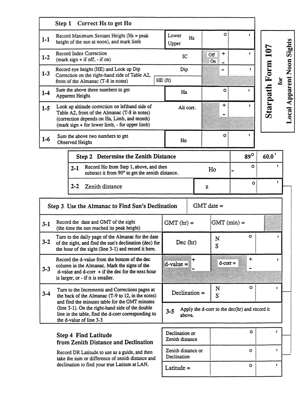
12 Work Forms 1 WT h m s date body Hs WE S F ZD W E Form 108 Combined form for Almanac Daily Pages plus NAO Tables DR Lat DR Lon GMT h m s GMT date / LOP label log HE ft index corr. off on DIP Ha 2 GHA hr. vmoon planets Dec HP hr d moon 3 GHA m.s. SHA or v corr. GHA stars or moon, planets d corr. Dec Dec min additional altitude corr. moon, mars, venus altitude corr. all sights upper limb moon subtract 30 Ho 4 alon WE LHA 00 W / 60 E 5 6 Location on table pages Top Sides Latitude N S LHA SR Table > A same contrary A' N S Declination D B F D' B' F' Z 1 sign B = sign Z 1 if LHA = 0 to 90 if LHA = 91 to 269 if LHA = 270 to 360 bar top means rounded value 30' or 0.5 rounds up A F SR Table > 7 H H' P P' Z 2 if F = 0 to 90 if F = 90 to F' 9 A' Z 2 Aux > P Aux > same sign as Z 2 but reverse sign if F' = 30 to 59 if A' = 30 to 59 if A' = 0 to 29 Hc = Ho = 11 a = alat = C 1 C 2 A T take label of larger T A Z = N. Lat S. Lat Z > alon = 3 Zn = > LHA 0 to to > > Z > This is a combined form for those using NAO tables. The instructions for the top part are essentially the same as for Form 104. Instructions for the bottom part are the same as for the NAO tables. [1] Fill in sight data. [2] Get GP data from daily pages for whole hour. [3] Get minutes and seconds corrections. Sum for GHA, Sum for Dec. Copy Dec to line in 6. Mark N or S. [4] Choose alon and find LHA. Copy to line [6]. Choose alat, record in line [5]. Record alat and alon in line [11]. [5] Apply altitude corrections to get Ho. Copy Ho to space above [11]. [6]to[10] Follow standard NAO form instructions. [11] Find avalue as difference between Hc and Ho, and choose its label. Now all data needed to plot the LOP is at hand. 245
13 Starpath Form 110 for Polaris Sights Step Correct Hs to get Ho Record Index Correction IC (mark sign if off, if on) Record eye height (HE) and look up Dip Look up the altitude correction in the center of Ha Alt corr. Ho Find LHA Aries UTC date = 21 UTC Time in Hours, Minutes and Seconds UTC time = Step 2 o o Find GHA Aries on Left Hand Daily Page 22 of the Nautical Almanac (far left column) GHA Aries (hr) = for UTC Day and Hour Find GHA Aries minutes and seconds correction from Increments and Corrections pages 24 Sum the above two numbers to get GHA Aries 25 DR Longitude (W, E) GHA Aries (m, s) = GHA Aries = DR Lon = 26 LHA Aries (Combine previous numbers, round to nearest degree) LHA Aries = Step 3 Latitude Determination 31 Ho (from 16) 32 a0 from Polaris Table (using LHA Aries) HO = 33 a1 from Polaris Table (using DR Latitude) 34 a2 from Polaris Table (using Month) 35 Subtract 1 degree a1 = 36 ' ' ' ' Table A2, front of the Almanac 16 Sum the above two numbers to get Observed Height 23 ' HE (ft) 14 Sum the above to get Apparent Height of Polaris 15 Off On Dip 13 Correction on the righthand side of Table A2, front of Almanac o Hs Record Sextant Height of Polaris Sum the above five numbers to get Latitude a0 = a2 = 1º = Latitude = '
14 How to measure Index Correction using the Sun This is an old method, developed by those explorers who did most sights on land using an artificial horizon (Lewis and Clark, for example). It can be quite accurate and offers a quick check by measuring the sun s semidiameter at the time of the sight and comparing that with the value listed in the Nautical Almanac or computed by the StarPilot. It is not entirely clear, however, if this solar IC method is superior for routine sights at sea using a true sea horizon. In these cases, it could be that the conventional methods we discuss elsewhere might be preferred. For lunar distance sights, on the other hand, this solar method is likely best. Notes (1) we will be looking straight toward the sun and through a telescope to boot. So we must be very careful that all sun shades are in place and we do not somehow distort our view and look around the edge of the shades. Do not under any circumstances look directly at the sun without it being completely covered by the shades. (2) Use the highest power scope you have for this. Monocular 6x35 or 7x30 etc work well. (3) Adjust the shades if you have that option so the reflected and direct view of the sun appear as different colors. Procedure (1) Set the sextant to and look toward the sun on a clear day. You will see something like the following, where we use the convention that shaded sun is the reflected view on the right side of the horizon mirror and the unshaded one is the direct view through the clear glass of the left side of the horizon glass Side error Index error Step 1 Reflected view Direct view Step Index error Side error removed (2) Adjust the side error to remove it by first adjusting the Index mirror to be perpendicular to the frame of the arc and then adjusting the horizon mirror so it is parallel to the frame as well. Then you will see the picture to the right above which is almost all index error with no side error. Step 3 First we will measure the Toward value of the IC (3) Turn the micrometer Away from you until all of the reflected image is well below the direct image
15 (4) Now turn micrometer Toward you slowly and uniformly so the reflected image rises till the top edge of it just touches the bottom edge of the direct image. And read the dial. It should read something like 32 on the scale depending on your IC. Record this ON value. Accurate to the tenth. In this running example we will call this 34.0 ON. (5) Now continue to turn, slowly and uniformly, in the Toward direction until the bottom edge of the reflected image aligns with the top edge of the direct image. If you overshoot, we need to start all over again!. The idea is to be turning only in one direction when we stop. This time the dial will read about 28 but this will be an OFF the scale measurement, so we have to subtract whatever it reads from 60. In this example, let s assume micrometer read 29.2, which would be 29.2 = 30.8 OFF the scale. Record this OFF value. Step 4 Step (6) Now take the difference between the ON value and the OFF value and divide that by 2 to find your IC. Just subtract the smaller from the larger. The label of your result will be the same as the label of the larger value. In this example: = 3.2 and 3.2 /2 = 1.6 and since 34 was ON, the answer is ON, ie our IC is 1.6 ON the scale. (7) Now check your result by comparing to the actual semidiameter of the sun at the time of the sight. Our example was measured on 02/28/01 using an Astra 3b deluxe model sextant with traditional mirror. From the Nautical Almanac, we get that SD = The SD of the sun equals the ON value plus the OFF value divided by 4. In this example, = 64.8 and 64.8/4 = 16.2 which is right. More notes A quick and dirty method to measure the IC this way, or maybe to double check the result to see that it all makes sense, is just to align the reflected and direct images on top of each other and read the dial. That reading will be your IC, it is just that the above procedure is a more accurate way to get the value. In this case we would see what is shown here, depending on whether or not we had side error. In our example, the dial would read 1.6 ON the scale when either of the two rightside alignments were set. Now you can repeat the full process turning always in the Away direction. Careful data will often show a slight No side error With side error difference for the Toward and Away values, even for a metal sextant (see sample data to follow). For plastic sextants, on the other hand, the toward and away values will almost always be rather large, some few minutes or so.
16 Date 2/28/01 SD 16.2 Toward or Away = 30.8 = = = 1.6 on = = 30.2 = = = 1.8 on = = 30.8 = = = 1.7 = = 30.4 = = = 1.8 = = 4 6. = 2 = 4 Date 2/28/01 SD 16.2 Toward or Away = 31.2 = = = 1.2 on = = 31.0 = = = 1.2 = = 31.0 = = = 1.2 = = 30.8 = = = 1.4 = = 30.8 = = = 1.4 = = 2 = 4 average = ( ) / 4 = 1.7 On when turning in the Toward direction. average = ( )/5 = 1.3 On when turning in the Away direction. This data is from navigator Lanny Petitjean using Astra w. traditional mirror. He has since used the results to achieve numerous sights from land with accuracies all below 0.4 miles and lunar distance sights below 30 seconds. Thanks Lanny.
17 Date SD Toward or Away 1. 2 = 4 2. = 2 = 4 Date SD Toward or Away 1. 2 = 4 2. = 2 = = 4 4. = 2 = = 4 4. = 2 = = 4 6. = 2 = = 4 6. = 2 = 4 Form for solar IC measurements Starpath School of Navigation
18 See discussion at: Celestial Navigation Workforms Form 111, Pub. 249, Vol. 1 1 WT h m s date body Hs WE S F ZD W E UTC h m s DR Lat DR Lon UTC date / LOP label log HE ft index corr. off on DIP Ha 2 3 GHA hr. GHA m.s. GHA alon WE LHA LHA alat Star N S 00 W / 60 E } Pub. North Latitudes LHA greater than Zn = Z LHA less than Zn = 360 Z South Latitudes LHA greater than Zn = 180 Z LHA less than Zn = 180 Z copy copy 249, Vol. 1 4 altitude corr. (refraction) Ho Hc T A a = Zn = a Lat = a Lon = TA 5 1 WT h m s date body Hs WE S F ZD W E UTC h m s DR Lat DR Lon UTC date / LOP label log HE ft index corr. off on DIP Ha 2 3 GHA hr. GHA m.s. GHA alon WE LHA LHA alat Star N S 00 W / 60 E } Pub. North Latitudes LHA greater than Zn = Z LHA less than Zn = 360 Z South Latitudes LHA greater than Zn = 180 Z LHA less than Zn = 180 Z copy copy 249, Vol. 1 4 altitude corr. (refraction) Ho Hc T A a = Zn = a Lat = a Lon = TA 5
CHAPTER 20 SIGHT REDUCTION
 CHAPTER 20 SIGHT REDUCTION BASIC PRINCIPLES 2000. Introduction Reducing a celestial sight to obtain a line of position consists of six steps: 1. Correcting sextant altitude (hs) to obtain observed altitude
SUN SIGHT REDUCTION CALCULATIONS
 SUN SIGHT REDUCTION CALCULATIONS Date: Ship s time: GMT at sight: h m s DR Position: Lat º N/S Long º E/W Ass Position: Lat º N/S Long º E/W GHA: º Decl: º N/S d = +/- Incrmnt º Corr: +/- GHA: º Decl:
CHAPTER 19 SIGHT REDUCTION
 CHAPTER 19 SIGHT REDUCTION BASIC PROCEDURES 1900. Computer Sight Reduction The purely mathematical process of sight reduction is an ideal candidate for computerization, and a number of different hand-held
Answers to Lyra Celestial Navigation Refresher Exercise
 Answers to Lyra Celestial Navigation Refresher Exercise Correcting Your Sight Reduction Forms Below are the sight reduction forms and plotting sheets for the navigation exercise. The sight reduction forms
Chapter 2. Altitude Measurement
 Chapter Altitude Measurement Although altitudes and zenith distances are equally suitable for navigational calculations, most formulas are traditionally based upon altitudes which are easily accessible
Complete Sun Sight Reduction Procedure
 Caution...2 Usage...2 Conventions...2 Assumptions...2 Explanation...2 Sight #...2 DR Latitude/DR Longitude...2 Date...2 GMT/UT...3 Hs...3 D. R. I. P. S...3 Index Error...3 Complete Sun Sight Reduction
Navigating by the Stars and Planets
 Navigating by the Stars and Planets (Finding your location from measured altitudes of celestial bodies) Presented to: Chagrin Valley Astronomical Society September 1, 2012 By Ron Baker, CVAS member Historical
INTRODUCTION FOREWORD
 FOREWORD The Sight Reduction Tables for Air Navigation consist of three volumes of comprehensive tables of altitude and azimuth designed for the rapid reduction of astronomical sights in the air. This
we will use these 4 data points
 Lunar Distance Example, reduced by Stark Tables and by Computer solutions Due to its own orbital motion around the earth, the apparent position of the moon among the stars changes daily. It circles the
Chapter 2: Measure of the Sun s Altitude: Ho
 The altitude (angle) of the sun above the horizon is traditionally measured with a sextant. 2.1 Principle of the Sextant The sextant measures the angle between what is seen straight through the clear window
ASTRONOMICAL NAVIGATION
 Basic terms ASTRONOMICAL NAVIGATION *astronomical navigation *compilation *astronomical tabels *celestial observations *solution of a sight * Sun/Moon/star sight *spherical trigonometry *PZX triangle *celestial
DUMMIES guide to Astro-Navigation
 DUMMIES guide to Astro-Navigation The idea of this booklet is to give you the nuts and bolts in the process of gaining a position on your chart through celestial navigation without a deep understanding
Chapter 6: Latitude by Noon Sight
 Chapter 6: Latitude by oon ight When the sun is crossing the meridian of the boat, it is straight south or north of the boat and at its highest altitude over the horizon for the day. The local meridian
Astro Navigation (i.e. Celestial Navigation)
") Name: Partner First Name: Astro Navigation (i.e. Celestial Navigation) Over the course of human lifetimes, the stars don t appear to change positions much. We can use that in order to determine locations
Name: Partner First Name: Astro Navigation (i.e. Celestial Navigation) Over the course of human lifetimes, the stars don t appear to change positions much. We can use that in order to determine locations
StarPilot-PC Manual StarPilot, LLC 3050 NW 63rd St. Seattle, WA, Tel:
 StarPilot-PC Manual StarPilot, LLC 3050 NW 63rd St. Seattle, WA, 98107 Tel: 206-783-1414 www.starpilotllc.com info@starpilotllc.com QUICK START INSTRUCTIONS This User's Guide is specific to the StarPilot-PC
How to Average Celestial Sights for Optimum Accuracy
 Averging Celestial Sights, David Burch, Page 1 How to Average Celestial Sights for Optimum Accuracy The beauty of celestial navigation is its transparency, meaning when we get a position fix using standard
National Maritime Center
 National Maritime Center Providing Credentials to Mariners Master TV to Master Less than 500 Gross Registered Tons Oceans or Near Coastal (Sample Examination) Page 1 of 5 Choose the best answer to the
AFPAM MARCH Chapter 8 CELESTIAL CONCEPTS
 AFPAM11-216 1 MARCH 2001 197 Section 8A Introduction to Celestial Concepts Chapter 8 CELESTIAL CONCEPTS 8.1. Basics. Celestial navigation is a universal aid to dead reckoning (DR). Because it is available
Altitude NAVIGATION. Visible Horizon
 Altitude Visible Horizon Rational Horizon Sensible Horizon Dip Polar Distance A small circle on the surface of the earth, containing the points of intersection between the observer s eye sight and the
SIGHT REDUCTION TABLES MARINE NAVIGATION
 PUB. NO. 229 VOL. 4 SIGHT REDUCTION TABLES FOR MARINE NAVIGATION LATITUDES 45 60, Inclusive Prepared and published by the NATIONAL IMAGERY AND MAPPING AGENCY Bethesda, Maryland 1970 Reprint:1980 COPYRIGHT1980
CHAPTER 2 INTERPOLATION
 CHAPTER 2 INTERPOLATION FINDING THE VALUE BETWEEN TABULATED ENTRIES 200. Introduction When one quantity varies with changing values of a second quantity, and the mathematical relationship of the two is
Modern Navigation. Thomas Herring
 12.215 Modern Navigation Thomas Herring Review of last Class Motion of the Earth and Sun Geometry of Earth/Sun system Astronomical coordinates Motion of the Earth around the sun Equation of Time Astronomical
LUNAR DISTANCES EXPLAINED ALONG WITH A STARTER KIT FOR THE SHORE BOUND NAVIGATOR
 LUNAR DISTANCES EXPLAINED ALONG WITH A STARTER KIT FOR THE SHORE BOUND NAVIGATOR ARTHUR N. PEARSON On the forty-third day from land, a long time to be at sea alone, the sky being beautifully clear and
A Celestial Navigation Primer
 Introduction A Celestial Navigation Primer by Ron Davidson The study of celestial navigation, whether for blue water sailing, the taking of a navigation class (like the United States Power Squadron's JN
National Maritime Center
 National Maritime Center Providing Credentials to Mariners (Sample Examination) Page 1 of 5 Choose the best answer to the following Multiple Choice questions. 1. On 24 July your 1912 zone time DR position
COMPUTATION PROGRAMS OF THE ASTRONOMICAL VESSEL POSITION
 Journal of Marine Science and Technology Vol. 19 No. 1 pp. 35-4 (011) 35 COMPUTATION PROGRAMS OF THE ASTRONOMICAL VESSEL POSITION Chih-Li Chen* and Tsung-Hsuan Hsieh* Key words: intercept method observed
How to find Sun's GHA using TABLE How to find Sun's Declination using TABLE 4...4
 1 of 8 How to use- TABLE 4. - GHA and Declination of the Sun for the Years 2001 to 2036- Argument Orbit Time How to find Sun's GHA using TABLE 4... 2 How to find Sun's Declination using TABLE 4...4 Before
National Maritime Center
 National Maritime Center Providing Credentials to Mariners Q127 Navigation Problems-Oceans (Sample Examination) Page 1 of 5 Choose the best answer to the following Multiple Choice questions. 1. You depart
StarPilot User's Guide for Apple iphone and ipod (Ver 1.14)
") for Apple iphone and ipod (Ver 1.14) Table of Contents 1 Quick Start Instructions... 5 Old routines, new manual... 5 Quick Start Examples... 6 Example of Running fix using GMT and date...6 Date input for
for Apple iphone and ipod (Ver 1.14) Table of Contents 1 Quick Start Instructions... 5 Old routines, new manual... 5 Quick Start Examples... 6 Example of Running fix using GMT and date...6 Date input for
PY 124: Terrestrial Position from Celestial Observations
 The linked image cannot be displayed. The file may have been moved, renamed, or deleted. Verify that the link points to the correct file and location. The linked image cannot be displayed. The file may
Celestial Observations Amplitude (Visible Horizon ) - Moon - Center on VH
 - Moon - Center on VH") LEGEND: USCG 2119-NP-5 Blue = information provided Black = calculated values Celestial Observations Amplitude (Visible Horizon ) - Moon - Center on VH Red = table values, etc. Green = ANSWER STEPS At 1622
LEGEND: USCG 2119-NP-5 Blue = information provided Black = calculated values Celestial Observations Amplitude (Visible Horizon ) - Moon - Center on VH Red = table values, etc. Green = ANSWER STEPS At 1622
National Maritime Center
 National Maritime Center Providing Credentials to Mariners Q207 Navigation Problems-Oceans (Sample Examination) Page 1 of 6 Choose the best answer to the following Multiple Choice questions. 1. On 1 December
T A T A. Starpath form a = Zn = a - Lat = a - Lon = a = Zn = + - a - Lat = a - Lon = Copyright, 2003 Starpath School of Navigation
 tarpath fm 0 W h m s ate boy Hs WE D W E Lat Lon GM h m s GM ate / LO label log HE ft inex off on DI Ha GH hr. v planets H hr GH m.s. H v GH alon WE eg alat 00 W / 60 E 5 stars, planets tens units s. tab.
Modern Navigation
 12.215 Modern Navigation Thomas Herring (tah@mit.edu), MW 11:00-12:30 Room 54-322 http://geoweb.mit.edu/~tah/12.215 Review of last Class Motion of the Earth and Sun Geometry of Earth/Sun system Astronomical
The Motion of the Observer. in Celestial Navigation
 The Motion of the Observer in Celestial Navigation George H. Kaplan Astronomical Applications Department U.S. Naval Observatory 3450 Massachusetts Avenue NW Washington, D.C. 20392-5420 The Motion of the
Meridian Circle through Zenith, North Celestial Pole, Zenith Direction Straight Up from Observer. South Celestial Pole
 Chapter 3 How Earth and Sky Work- Effects of Latitude In chapters 3 and 4we will learn why our view of the heavens depends on our position on the Earth, the time of day, and the day of the year. We will
Modern Navigation. Thomas Herring
 12.215 Modern Navigation Thomas Herring Review of Last Class Almanacs: Paper and electronics Paper Almanacs: Nautical Almanac Electronic: Available on many web sites Homework #1 solutions 10/17/2006 12.215
Celestial Navigation. with. Sextant and Calculator HP-42S
 Celestial Navigation with Sextant and Calculator HP-42S Ackermans Harry 2017 Abbreviations and symbols LOP1 = Line of position 1 LOP2 = Line of position 2 COP1 = Circle of position 1 COP2 = Circle of position
MARINE SEXTANT INTRODUCTION
 MARINE SEXTANT INTRODUCTION The marine sextant is used by the mariner to observe the altitude of celestial bodies as well as to measure horizontal and vertical angles of terrestrial objects. On the image
To be able to calculate the great circle distance between any two points on the Earth s surface.
 17. Great Circles Objective To be able to calculate the great circle distance between any two points on the Earth s surface. Introduction The shortest distance between any two points on the Earth s surface
Office 307 Breshnahan Hall Phone: ext MT3121 CELESTIAL NAVIGATION II
 MT3121 CELESTIAL NAVIGATION II Learning Objective Celestial Navigation II will cover the requirements of the 1978 STCW convention as amended in 1995. The course covers the theory and practice of navigation
National Maritime Center
 National Maritime Center Providing Credentials to Mariners (Sample Examination) Page 1 of 5 Choose the best answer to the following Multiple Choice questions. 1. On 15 October your 0300 zone time DR position
CHAPTER II THE COORDINATES SYSTEM AND FORMULARIES
 CHAPTER II THE COORDINATES SYSTEM AND FORMULARIES www.loxodrome.org/ Introduction to Celestial Navigation/Chapter II THE CO-ORDINATES SYSTEMS AND FORMULARIES In previous section we had a purely geometrical
Chapter S1 Celestial Timekeeping and Navigation. How do we define the day, month, year, and planetary time periods?
 Chapter S1 Celestial Timekeeping and Navigation S1.1 Astronomical Time Periods Our goals for learning:! How do we define the day, month, year, and planetary time periods?! How do we tell the time of day?!
Geometry of Earth Sun System
 12S56 Geometry of Earth Sun System Figure below shows the basic geometry Northern Hemisphere Winter ω equator Earth s Orbit Ecliptic ω ω SUN equator Northern Hemisphere Spring Northern Hemisphere Fall
This unit is primarily aimed at learners who intend to seek employment within the maritime industry.
 General information for centres Unit title: Celestial Navigation (SCQF level 8) Unit code: HW6M 48 Superclass: RE Publication date: November 2017 Source: Scottish Qualifications Authority Version: 01 Unit
Celestial Navigation
 A Short Guide to Celestial Navigation Copyright 1997-011 Henning Umland Permission is granted to copy, distribute and/or modify this document under the terms of the GNU Free Documentation License, Version
Celestial Navigation. 6. Time Objective Greenwich Mean Time
 6. Time Celestial Navigation 6.1. Objective By the end of this section you will know more about time than you thought possible. In particular you will learn how time and longitude are related, understand
UNIT 6 CELESTIAL SPHERE AND EQUINOCTIAL SYSTEM OF COORDINATES
 UNIT 6 CELESTIAL SPHERE AND EQUINOCTIAL SYSTEM OF COORDINATES Structure 6.1 Introduction Objectives 6.2 References 6.3 Apparent Annual Motion of the Sun and the Concept of the Ecliptic and the Obliquity
Manual and Documentation for Teacup Celestial version 3.2a Software revision 3a
 Manual and Documentation for Teacup Celestial version 3.2a Software revision 3a By Teacup Navigation Rodger E. Farley Contents Introduction Note as to compatibility with the previous version Sight Planner
StarPilot. StarPilotTM. users guide. for TI-89, 92+ and Voyage 200. TI calculator manuals included on CD
 StarPilotTM users guide for TI-89, 92+ and Voyage 200 TI calculator manuals included on CD StarPilot Copyright 2002-2018, StarPilot, LLC 3050 NW 63rd St, Seattle, WA 98107 Printed in the USA StarPilot-89
Marine Sextants: History & Technology
 Title: Marine Sextants: History & Technology (Coastal Navigation) Grade(s): 6-8 Introduction: Today s low cost metal sextants offer high accuracy and ease of use. Plastic models are perfect for lifeboat
Modern Navigation. Thomas Herring
 12.215 Modern Navigation Thomas Herring Review of Monday s Class Spherical Trigonometry Review plane trigonometry Concepts in Spherical Trigonometry Distance measures Azimuths and bearings Basic formulas:
Planetary Science Unit Map Grade 8
 Planetary Science Unit Map Grade 8 Course Goal and Description: In Planetary Science students study the Earth as a celestial object before progressing to lunar science/exploration, and then to Solar System
ASTRONOMY Merit Badge Requirements
 ASTRONOMY Merit Badge Requirements 1) Do the following: A) Sketch the face of the moon, indicating on it the locations of at least five seas and five craters. B) Within a single week, sketch the position
CHAPTER 2 SKILL SHEET 2: CELESTIAL NAVIGATION
 CHAPTER 2 SKILL SHEET 2: CELESTIAL NAVIGATION Before the invention of GPS technology, how were people on ships far at sea, out of the sight of land, able to tell where they were? For thousands of years
 Chapter 2 Altitude Measurement Although altitudes and zenith distances are equally suitable for navigational calculations, most formulas are traditionally based upon altitudes since these are easily accessible
CHAPTER 24 THE SAILINGS
 CHAPTER 24 THE SAILINGS INTRODUCTION 2400. Introduction Dead reckoning involves the determination of one s present or future position by projecting the ship s course and distance run from a known position.
The Celestial Sphere. Chapter 1. Constellations. Models and Science. Constellations. Diurnal vs. Annular Motion 9/16/2010
 The Celestial Sphere Chapter 1 Cycles of the Sky Vast distances to stars prevent us from sensing their true 3-D arrangement Naked eye observations treat all stars at the same distance, on a giant celestial
OCN 201 LAB FALL 2003 POLYNESIAN AND WESTERN NAVIGATION
 Name: OCN 201 LAB FALL 2003 POLYNESIAN AND WESTERN NAVIGATION INTRODUCTION People have been sailing the seas for thousands of years, during most of which time they relied on the sun and the stars to navigate
Celestial Sphere Spectroscopy (Something interesting; e.g., advanced data analyses with IDL)
") AST326, 2010 Winter Semester Celestial Sphere Spectroscopy (Something interesting; e.g., advanced data analyses with IDL) Practical Assignment: analyses of Keck spectroscopic data from the instructor (can
AST326, 2010 Winter Semester Celestial Sphere Spectroscopy (Something interesting; e.g., advanced data analyses with IDL) Practical Assignment: analyses of Keck spectroscopic data from the instructor (can
We note that Philly Wings is the farthest off, but the others should give a good east-west and north-south measure of the pressure surface slope.
 After entering a randomly selected east coast location of lat = 39 49.00 N, 75 26.00 W we get the following screen after pressing Show Stations. It shows the 10 closest stations with online pressure data
Acknowledgments Piloting The Art of Navigation p. 3 The Shipboard Navigation Department Organization p. 6 Duties of the Navigator p.
 Foreword p. xiii Acknowledgments p. xv Piloting The Art of Navigation p. 3 The Shipboard Navigation Department Organization p. 6 Duties of the Navigator p. 7 Relationship of the Navigator to the Command
EXPLANATION OF NAVIGATION TABLES
 EXPLANATION OF NAVIGATION TABLES Mathematical Tables Table. Logarithms of Numbers The first page of this table gives the complete common logarithm (characteristic and mantissa) of numbers through 250.
Chapter S1 Lecture. The Cosmic Perspective Seventh Edition. Celestial Timekeeping and Navigation Pearson Education, Inc.
 Chapter S1 Lecture The Cosmic Perspective Seventh Edition Celestial Timekeeping and Navigation 2014 Pearson Education, Inc. Celestial Timekeeping and Navigation 2014 Pearson Education, Inc. S1.1 Astronomical
Determining the Position and Motion of a Vessel from Celestial Observations. George H. Kaplan U.S. Naval Observatory
 Determining the Position and Motion of a Vessel from Celestial Observations George H. Kaplan U.S. Naval Observatory Abstract Although many mathematical approaches to the celestial fix problem have been
CA1 2.11: Designing an Equatorial Sundial Activity
 Purpose: To design an equatorial sundial and learn about motions of the sun and earth that have a bearing on its design. Materials: poster board, length of stiff wire or dowel rod, tape, protractor, ruler,
Astronomy Review. Use the following four pictures to answer questions 1-4.
 Astronomy Review Use the following four pictures to answer questions 1-4. 1. Put an X through the pictures that are NOT possible. 2. Circle the picture that could be a lunar eclipse. 3. Triangle the picture
Computer Activity #3 SUNRISE AND SUNSET: THE SEASONS
 NAME(S)!!!!!!!!!!!!!!!!!!!!!!!!!!!!!!!!!! ASTRONOMY 25 Computer Activity #3 SUNRISE AND SUNSET: THE SEASONS SECTION DAY/TIME S. V. LLOYD Overview The seasonal variation in temperature is due to two changes
MIDTERM PRACTICE EXAM ANSWERS
 MIDTERM PRACTICE EXAM ANSWERS 1. (2) Location B shows that the altitude of the noon Sun increases between Dec 21. and June 21. Location B also shows that the Dec. 21 noon Sun is at an altitude of approximately
Astronomy Studio Exercise Geocentric and Heliocentric World Views Guy Worthey
 Astronomy Studio Exercise Geocentric and Heliocentric World Views Guy Worthey We explore in some detail how the geocentric cosmology worked, and what observations caused the adoption of the heliocentric
Observing the Night Sky: Locating Objects
 Observing the Night Sky: Locating Objects As I left the house this morning, there was a bright bluish light above and to the left of my neighbors house (approximately East) and a big very bright object
CHAPTER 26 EMERGENCY NAVIGATION
 CHAPTER 26 EMERGENCY NAVIGATION BASIC TECHNIQUES OF EMERGENCY NAVIGATION 2600. Planning for Emergencies Increasing reliance on electronic navigation and communication systems has dramatically changed the
APPENDIX B CALCULATIONS AND CONVERSIONS
 APPENDIX B CALCULATIONS AND CONVERSIONS INTRODUCTION App B 1. Purpose and Scope This chapter discusses the use of calculators and computers in navigation and summarizes the formulas the navigator depends
RYA / DOT Yachtmaster Ocean Revised Course for 2007 Onward Day is a concept born of planets spinning captive about a star...
 RYA DOT Yachtmaster Ocean / Astro Class 4. Course Content RYA / DOT Yachtmaster Ocean Basics, History, Time, Longitude and Latitude, The Sextant. Essentials, Ships Log, Ocean Charts, Sextant, Time Piece,
PHSC 1053: Astronomy Time and Coordinates
 PHSC 1053: Astronomy Time and Coordinates Astronomical Clocks Earth s Rotation on its Axis Time between two successive meridian transits of the sun 1 solar day (our adopted clock time) 24 hours (86,400
Andrés Ruiz San Sebastián Donostia 43º 19 N 002ºW
 Vector equation of the circle of equal altitude Andrés Ruiz San Sebastián Donostia 43º 19 N 002ºW http://sites.google.com/site/navigationalalgorithms/ 2 Index Vector equation of the circle of equal altitude...
Astrology Class Madison, Wisconsin. 43 North 89 West. September Daylight
 Astrology Class Madison, Wisconsin 43 North 89 West 7 32 September 21 2005 Daylight Astrology Class Madison, Wisconsin September 21,2005 7:32 43 North 89 West Names & Planetary Character Luminaries Symbols
Modern Navigation. Thomas Herring
 12.215 Modern Navigation Thomas Herring Review of last Class Review of linear Algebra. Class will be based on the book Linear Algebra, Geodesy, and GPS, G. Strang and K. Borre, Wellesley-Cambridge Press,
Name Class Date. For each pair of terms, explain how the meanings of the terms differ.
 Skills Worksheet Chapter Review USING KEY TERMS 1. Use each of the following terms in a separate sentence: year, month, day, astronomy, electromagnetic spectrum, constellation, and altitude. For each pair
Copyright Henning Umland
 Copyright 997-00 Henning Umland ll Rights Reserved Revised May 4, 00 Legal Notice. License and Ownership The archive file astro.zip is NOT public domain but rather is a licensed product. The file astro.zip,
Chapter 1 Image Slides. Copyright The McGraw-Hill Companies, Inc. Permission required for reproduction or display.
 Chapter 1 Image Slides Copyright The McGraw-Hill Companies, Inc. Permission required for reproduction or display. CH. 1: CYCLES OF THE SKY CO a 1.1 The Celestial Sphere CO b The nearest star to us is about
Exercise 7.0 THE CHANGING DIURNAL CIRCLES OF THE SUN
 Exercise 7.0 THE CHANGING DIURNAL CIRCLES OF THE SUN I. The Apparent Annual Motion of the Sun A star always rises and sets at the same place on the horizon and, hence, it is above the horizon for the same
Guide to Polar Alignment of a Meade LX200GPS Telescope
 Guide to Polar Alignment of a Meade By Dale A. Chamberlain dale@dchamberlain.net April 18, 2006 Page 1 of 11 1 Why Polar Align? After making an investment in a telescope such as the Meade LX200GPS, you
Phys Lab #1: The Sun and the Constellations
 Phys 10293 Lab #1: The Sun and the Constellations Introduction Astronomers use a coordinate system that is fixed to Earth s latitude and longitude. This way, the coordinates of a star or planet are the
CHAPTER 14 INSTRUMENTS FOR CELESTIAL NAVIGATION
 CHAPTER 14 INSTRUMENTS FOR CELESTIAL NAVIGATION 1400. Description and Use The marine sextant measures the angle between two points by bringing the direct image from one point and a double-reflected image
NAVIGATION THEORY QUESTIONS Basics of Navigation
 NAVIGATION THEORY QUESTIONS Basics of Navigation Q610065 look at it The angle between the plane of the ecliptic and the plane of equator is approx? 23.5 degrees In which two months of the year is the difference
Understanding Celestial Navigation
 Understanding Celestial Navigation By Ron Davidson, SN Poverty Bay Sail & Power Squadron I grew up on the Jersey Shore very near the entrance to New York harbor and was fascinated by the comings and goings
Telescopes come in three basic styles
 Telescopes come in three basic styles Refracting telescopes use lenses Refractors are either achromatic (some color distortion) or apochromatic (very little if any color distortion). Apo refractors use
ASTRO~NAVIGATION PILOTING &.. !--- --"'l~_f DEAD RECKONING
 ASTRO~NAVIGATION PILOTING!--- --"'l~_f &.. DEAD RECKONING Semidiameter (S.O,) of the Sun and Horizontal Parallax (H.P.) of Venus and Mars. For Sextant Altitude corrections S.D. Sun @ January 16:3 July
4 Solar System and Time
 4 olar ystem and Time 4.1 The Universe 4.1.1 Introduction The Universe consists of countless galaxies distributed throughout space. The bodies used in astro navigation belong to the Galaxy known as the
DRAFT OF NOMENCLATURE & TERMINOLOGY FOR IAU WG 1
 s TIO terrestrial intermediate origin DRAFT OF NOMENCLATURE & TERMINOLOGY FOR IAU WG 1 This is not a complete list. Symbols are not, and need not necessarily be unique, eg φ is used for latitude, both
Astro 101 Lab #2. Start up the Stellarium program. If you do not remember how to use the user interface, please refer to Lab#1 or the user s guide.
 Name: Astro 101 Lab #2 Lab objectives 1) Learn about how the Sun s path, through the sky, changes with the changing seasons. 2) Learn about how the Sun s path changes while viewing it at different locations
IESO 2011 ASTRONOMY PRACTICAL TEST STOP 11
 IESO 2011 ASTRONOMY PRACTICAL TEST STOP 11 NAME:- COUNTRY: On Friday, September 9, 2011, you will perform 3 trials. Each trial is individual, but in some cases you will have to work together with some
COMPUTER ACTIVITY 3: THE SEASONS: LENGTH OF THE DAY
 NAME ASTRONOMY 20 SECTION DAY/ S. V. LLOYD COMPUTER ACTIVITY 3: THE SEASONS: LENGTH OF THE DAY Overview Software Configuration The seasonal variation in temperature is due to two changes in the Sun's path
CHAPTER 2 A USER'S GUIDE TO THE SKY
 CHAPTER 2 A USER'S GUIDE TO THE SKY MULTIPLE CHOICE 1. In one way of naming stars, a letter indicates its brightness relative to the other stars in the constellation. a. English b. Arabic c. Greek d. Cyrillic
Appearance of the Sky Orientation Motion of sky Seasons Precession (?)
") Today Appearance of the Sky Orientation Motion of sky Seasons Precession (?) The Celestial Sphere Stars at different distances all appear to lie on the celestial sphere. The ecliptic is the Sun s apparent
Today Appearance of the Sky Orientation Motion of sky Seasons Precession (?) The Celestial Sphere Stars at different distances all appear to lie on the celestial sphere. The ecliptic is the Sun s apparent
Celestial Navigation in a Teacup
 Celestial Navigation in a Teacup Formerly The Armchair Celestial Navigator Concepts, Math, History, the Works, but Different Teacup Navigation Rodger E. Farley 2 Contents Chapter 1 Chapter 2 Chapter 3
Lab Title: Parallax and Astronomical Distances. Equipment: Sextant Meter sticks (or tape measures) Calipers Magnetic compasses.
 Calipers Magnetic compasses.") Lab Title: Parallax and Astronomical Distances Equipment: Sextant Meter sticks (or tape measures) Calipers Magnetic compasses Introduction: Since we cannot travel to most celestial objects in order to
Lab Title: Parallax and Astronomical Distances Equipment: Sextant Meter sticks (or tape measures) Calipers Magnetic compasses Introduction: Since we cannot travel to most celestial objects in order to
The celestial sphere, the coordinates system, seasons, phases of the moon and eclipses. Chapters 2 and S1
 The celestial sphere, the coordinates system, seasons, phases of the moon and eclipses Chapters 2 and S1 The celestial sphere and the coordinates system Chapter S1 How to find our way in the sky? Let s