A Celestial Navigation Primer
|
|
|
- Job Rodgers
- 6 years ago
- Views:
Transcription
, or for pure intellectual pursuit, is often considered to be a daunting subject. In part, that is because there are so many details associated with position finding.")
1 Introduction A Celestial Navigation Primer by Ron Davidson The study of celestial navigation, whether for blue water sailing, the taking of a navigation class (like the United States Power Squadron's JN or N classes), or for pure intellectual pursuit, is often considered to be a daunting subject. In part, that is because there are so many details associated with position finding. There are abbreviations, corrections, formulas, tables, and some challenging diagrams that may be difficult to understand. All of these (and more) serve to confuse the student, particularly if the study delves deep into the details before giving perspective and understanding of basic principles. Many of the available publications on the subject tend to focus on a cookbook how-to approach focused on the mechanics of sight reduction without providing an overview of the critical, clear-cut scientific basis of how and why celestial navigation works. It is the purpose of this primer to give that perspective and an understanding of basic celestial navigation principles so that the student's subsequent study will be more grounded and informed and perhaps, easier. The author of this primer does not wish to replace the student's study materials. Those have definite value for their detail, diagrams, problem exercises, plotting conventions, and more. The author of this primer is hopeful that the student will refer back to this treatise periodically, so as to retain the "big picture" of celestial navigation. Steps required for Standard Navigation: 1. Keep a deduced reckoning (DR) track on a chart using course steered and the Distance- Speed-Time formula 60D = ST. 2. Periodically verify the DR by other means. Additional steps required of Celestial Navigation: 1. Take a sight of a celestial body using a sextant. 2. Establish, via mathematics, a second sight; called a reference sight. 3. Compare the actual sight altitude reading to the reference sight altitude calculated. 4. Plot the result of the comparison on a plotting sheet. The Three Essentials That Are Required: 1. Knowledge of the positions of celestial bodies with respect to time. 2. Precise measurement of the time of observation. 3. Angular measurements (altitudes) between the celestial body and a known reference. The reference used in marine navigation is the visible horizon. a. A scientific calculator is extremely helpful in solving trigonometry equations. 1
2 The Nautical Almanac At the heart of celestial navigation is the Nautical Almanac. The Nautical Almanac is produced each year jointly by Her Majesty s Nautical Almanac Office and the Nautical Almanac Office of the U. S. Naval Observatory, and contains astronomical data of the Sun, Moon, Venus, Mars, Jupiter, and Saturn, et al, tabulated in 3-day sections for each whole hour of each day of the almanac year. What the Nautical Almanac can do is provide the data necessary to allow the navigator to identify the altitude above the horizon and azimuth (true bearing) of each celestial body for each second of each hour for any position on earth. This is done through the use of spherical trigonometry, whose formulas are already established. The student need not be concerned with the derivation of the formulas, but rather with the proper input of the pertinent elements into the formulas. Having observed the altitude of a celestial body at a specific time, the Nautical Almanac can also provide the data that can be used to help determine a position on earth. This, again, is through the use of spherical trigonometry. The observer records the altitude measured of a celestial body above the horizon, and records the time of observation (to the second), and is able to use the data from the Nautical Almanac to create an "observed altitude" from that position on earth. Additional almanac data is then extracted to create a calculated altitude for position, used for comparison to determine the observer s estimated position at the time of the sight. Again, this is done through the formulaic solution of spherical trigonometry. Thus, the Nautical Almanac is the "go to" reference to establish the inputs for the formulas that will solve for location on earth. A caveat: the student must understand the layout of the Nautical Almanac, the data included therein, the abbreviations used, and the application of various adjustments or corrections. In addition, the use of "Aries" as a reference point for navigational stars will be another topic of study. Key understandings for the use of Nautical Almanac: 1. Given a specific location on earth, the Almanac will provide the data necessary for the navigator to determine a celestial body s altitude above the horizon and the true bearing (azimuth) of a celestial body at any time (down to the second) from that location. 2. Given a specifically measured altitude of a celestial body at a specific time (down to the second) the Almanac will provide the data used to determine the position of the observer. Each of the above understandings assumes the use of spherical trigonometry and the associated formulas to give the proper results. These are topics covered later in this Primer. It is important to note that the principles of spherical trigonometry and the associated formulas are not the essentials of study here. Nevertheless, the derivation of the inputs to the formulas is key to successful outcomes and positioning. 2
3 The Fundamental Celestial Navigation Procedure: 1. Determine your present deduced reckoning (DR) position. a. A specific latitude and longitude pin-pointed; this is not your actual location; we ve yet to determine that. It is your best guess based on your navigation principles employed. 2. Measure the observed altitude angle of an identified celestial body above the horizon. 3. Record the name of the body sighted, the measured altitude, and the precise time of observation. 4. Make corrections to measurements for sextant Instrument Error and Dip (horizon error). 5. Establish the reference sight, based on the DR location by extracting the tabulated ephemeris data from the nautical almanac and recording. 6. Utilize a calculation algorithm and apply mathematics such as the Law of Cosines formulas to solve. 7. Plot the results on a plotting sheet to identify and record the position determined nearest your DR position. Time The observation of a celestial body to determine position is dependent on the time of the observation. For practical purposes, the celestial bodies are fixed in the sky, but the earth is rotating at approximately 1000 mph! That suggests that every second, the celestial body s location in the sky, relative to our position, is moving. (Actually, we are moving.) Thus, when we observe an altitude of a celestial body from Earth, its longitudinal position is changing every second! This renders the precision in the measurement of time associated with an altitude observation of a celestial body of utmost importance. Beyond precision, there are the conventions of time measurement to be considered. For example, there are 24 time zones across the globe. These are typically established by political entities for various purposes, including ease of commerce and communication, i.e., to help our societies function more efficiently. Time, across a particular time zone, is constant, regardless of the relationship of the sun or celestial bodies. This is an issue for the navigator, given the precision that is required to track celestial bodies. The solution to the challenge of time precision and specificity is the use of Universal Time (UT). The Nautical Almanac utilizes UT in pinpointing celestial bodies. Therefore, it is the responsibility of the student/navigator to learn how to convert local time to UT in order to extract the appropriate data from the Almanac. Time, a Further Discussion The Earth s orbit around the Sun is a slightly elliptical one, with a mean distance from the Sun equal to 1 Astronomical Unit (AU = 80,795,193 nautical miles). This means that the Earth is sometimes a little closer to and sometimes a little farther from the Sun than 1 AU. When it is closer, the gravitational forces between Earth and Sun are greater and it is like going downhill where the Earth travels a little faster thru its orbital path. When it is farther away, the gravitational forces are less and it is like going uphill where the Earth travels a little slower. 3
 where every day is exactly 24 hours long and noon occurs at")
4 Because the Earth s orbit is not perfectly circular and its orbital velocity is not constant, the precise measurement of time is affected. We keep time by the movement of the Sun called solar time. For keeping time on our clocks, the movement of the Sun across the sky is averaged to become an imaginary mean Sun (establishing mean time) where every day is exactly 24 hours long and noon occurs at 1200 every day. However, the real or apparent Sun (establishing apparent time) is not constant and leads us to the time-related event that may be most familiar, the leap year, where we must add a day to our calendar every four years to keep our calendar time synchronized. Navigators keep watch time like the rest of the world, using mean solar time however they also must learn about and use appropriate apparent time, the Sun s actual movement. Throughout the year noon, when the Sun is directly over the observer s meridian of longitude, actually varies from occurring 16 minutes early at 1144 watch time around early November to 14 minutes late at 1214 watch time around mid-february. This difference in time between mean time and apparent time is called the Equation of Time and is listed on the Daily pages of the Nautical Almanac. We typically ignore this difference for day-to-day living but to the mariner, it can mean the difference between a pleasant cruise and loss of the vessel or worse! The Earth is a sphere 1 with 360 of circumference and sunrise occurs every 24 hours. The Sun travels 360 every 24 hours. Therefore, the Sun must move across the sky at an average of 15 per hour (360 24) or 1 every 4 minutes (60 15). Mathematicians have determined that, at the Equator, 1 = 60 nautical miles. If a mariner s time were incorrect by 16 minutes a position error of 4 or 240 nautical miles could result! Mariners must be able to determine apparent time as well as mean time. In addition to mean and apparent time, the Earth s circumference is divided into 24 one-hour (15 ) time zones. See the figure below right. The time zones begin (or end) at the Greenwich Meridian (0 longitude), the Z or Zulu time zone, spanning 7½ east and west of the 0 meridian and progress both easterly and westerly from Greenwich every 15 (1 hour) to meet at the International Date Line at 180 longitude. Midnight at Greenwich occurs when the Sun is over the 180 meridian (International Date Line). Noon at Greenwich occurs when the Sun is directly over the 0 meridian. The world time kept at Greenwich is called Universal Time (UT), formerly Greenwich Mean Time. The times of celestial body movements recorded in the Nautical Almanac for each hour of each day are listed in UT. The mariner must also have the skill to convert local time (Zone Time (ZT)) of his/her time zone to UT in order to extract appropriate data from the almanac. Remember, the Sun rises in the east and sets in the west. The time on a clock in a time zone to the east is ahead of the time on a clock of another time zone to the west. For example, if a mariner were located at 128 W longitude and zone time is 1045, what is UT? First, divide the longitude 128 by 15 to get ; and round to the nearest integer of 9 as the time zone. 1 Actually an oblate spheroid; a sphere slightly flattened at the poles. 4
5 The mariner is 9 times zones west of Greenwich. Greenwich is 9 time zones east of the mariner and 9 hours ahead of the mariner s ZT. Therefore, UT is: = 1945 UT at Greenwich. If the mariner were at 37 E longitude at ZT 1045, what is UT? = rounded to 2. Greenwich is two time zones west of the mariner therefore UT is 2 hours behind ZT, UT = = 0845 UT. If a mariner s position is in west longitude, one hour per time zone is added to local time to determine UT; if a mariner s position is in east longitude, one hour per time zone is subtracted from local time to determine UT. Noon in any time zone occurs when the Sun is directly over the central meridian of the zone. Mariners keep Standard Time aboard ship; daylight time is ignored. Time is longitude! The Earth rotates one revolution (360º of longitude) in one day. It therefore turns one degree of longitude in 1/360 th of a day, or every four minutes. 24 hours per day X 60 minutes per hour = 1440 minutes 360 = 4 minutes per degree. To calculate your longitude, you simply need to determine the time difference between time at your location and time at the Greenwich (0 ) Meridian. Local Mean Time Another time topic that a mariner s knowledge requires is called Local Mean Time (LMT). LMT accounts for the difference in longitude between a mariner s position and the central meridian of his/her time zone. We learned above that for each degree of longitude time differs by 4 minutes. Time zones are 15 wide with ½ the zone (7½ or 30 minutes) to the east and ½ (7½ or 30 minutes) to the west of the central meridian of the zone and noon for a time zone is when the Sun is directly over the central meridian of the time zone. Here s an example to demonstrate LMT: A mariner is located at 133 W longitude. At what time will the Sun be over the mariner s meridian (local noon at that position)? We know that noon for the time zone is when the Sun is over the central meridian of the time zone. Which meridian is the central meridian? Divide the longitude of 133 W by 15 per zone and the result is rounded to 9. The mariner s time zone is 9 time zones west of Greenwich and 9 * 15 yields 135 W as the central meridian of the time zone. However, the mariner at 133 W is located 2 east of the central meridian of 135 W. The Sun will cross 133 W before it will cross 135 W. Therefore, Local Apparent Noon (LAN) at 133 W must occur earlier than How much earlier? We learned earlier that the Sun moves 1 every 4 minutes. We are 2 east of the zone meridian of 135 W so local noon must occur 8 minutes before noon at the central meridian or at 1152 ZT. Thus the LMT of noon at 133 W is Had the mariner waited until 1200 ZT to take a noon sight for latitude, he/she would have missed local noon by 8 minutes or 120 miles! Now suppose the mariner were at 137 W. At what time would local noon occur? Did you get 1208? Remember, zone time is average (mean) time and we as a society agree that all clocks within the zone read 1200 when the Sun is over the central meridian of our time zone. However, this demonstration highlights the fact that Local Apparent Noon (LAN) occurs earlier for those east of the central meridian and later for those west of the central meridian. The mariner must account for his/her difference in longitude from the central meridian when taking (noon) sights. DLo = Lo ZM the difference in longitude (DLo) is our longitude minus the longitude of the central meridian (Zone Meridian (ZM)). Consider the following example: 5
6 At what time must a mariner be ready to take a noon sight for latitude if the mariner is located at Lo W? The mariner must determine the LMT of noon. Solution: Determine the ZM of the time zone: Lo = 55 + (25/60) = = rounded to 4. The mariner is 4 time zones west of Greenwich; central meridian (ZM) is 4 * 15 = 60 W. DLo = = The time difference is * 4 min per = = -18 minutes 20 seconds. The LMT of noon = m 20 s = The mariner s longitude is east of the ZM so LMT of noon is 18 minutes and 20 seconds earlier than noon at the ZM. The mariner must be prepared to begin taking sights before Altitudes and Co-Altitudes Background: Those interested in celestial navigation understand that knowledge of working with angles (degrees, minutes, and tenths of minutes) is required and many find that alarming or intimidating. Yes, angles are involved and spherical trigonometry is ultimately employed to obtain the results, however, navigators do not need to study the theory behind spherical trigonometry, they just need to know some basic arithmetic and how to use the two formulas provided. It is easier to understand the celestial navigation process if we first understand a few basic concepts being employed. Concept #1: Angles and Complements. The figure below shows a 90 angle between the vertical and horizontal lines and also shows an angle of 30 from horizontal and asks for the complement of the angle. The complement of an angle is the difference between the angle shown and 90 i.e the angle, in this case, = 60. This next figure shows another example of finding the complement of an angle. 6
 and 01 is 1 nm.")
7 Here are two more examples although these examples are using a person s location and Earth s latitude as the angle the concept, however, remains the same. You should have little trouble identifying the complements. Concept #2: Distances: Mathematicians have determined that 1 of latitude equals 60 nautical miles (nm) and 01 is 1 nm. Based on that knowledge and knowledge of complements, we can calculate the distance between a person s location and another known point. For instance, if two persons were separated by 3 we could calculate the distance between them by 3 X 60nm per degree = 180 nautical miles distance. Based on the two figures above we could then calculate our distance from the North Pole (Pn): If we were located at 15 N Latitude, how far are we from the Pn? = 75 = 75 X 60 = 4500 nm. If we were located at 60 N Latitude, how far are we from the Pn? = 30 = 30 X 60 = 1800 nm. The complement of our latitude tells us the distance to the North Pole! The complement of latitude is called Co-Latitude. Concept #3: Circle of Position. The distance between our location and some known point creates a Circle of Position (COP). The figure below shows a vessel that has detected via radar, a buoy at a range of 5nm. If the navigator located that buoy on a chart and, using a drawing compass set to the 5nm distance, the navigator could place the point of the compass on the buoy and draw a circle around that buoy creating a circle of position with a radius of 5nm. The navigator would know that the vessel is located somewhere on that circle. To determine where on the circle, the navigator would read the radar bearing to the buoy and plot that bearing on the chart. Where the bearing and the COP intersect would be the vessel s location. 7
8 Concept #4: Measuring altitude using a sextant. A navigator observes a celestial body in the sky and uses a sextant to measure the altitude of the body above the horizon. The horizon constitutes the horizontal reference line and the measured angle provides, indirectly, the complement angle as shown in the figure below: For celestial navigation, the COP concept from above, is employed. The celestial body s Geographical Position (GP) is the buoy and the 3,480nm is the radius of the circle of position from the GP of the celestial body. The mariner is located somewhere on that COP. Plotting that large circle on a chart as we did the radar COP, is impractical because the circle s radius is so huge! Even if we had a chart of small enough scale to plot the circle, the scale of the chart would make it impossible to plot an accurate position. The solution to this dilemma is a mathematical one versus a mechanical one and will be covered in more detail later. The distance of 3,480nm is the distance between the mariner s location and the location of the GP. An imaginary line connecting the celestial body to the Earth s center passes through the Earth s surface at the GP. The navigator determines the precise location (latitude and longitude) of the GP from the data recorded in the Nautical Almanac. The complement of the measured altitude measures the distance between the mariner s location and the location of the GP. In the figure above that distance is 3,480nm. The actual sextant measurement (with some corrections applied) of a body s altitude is called the Observed Altitude and is abbreviated Ho; H for height or altitude and o for observed. Once a sextant measurement of the altitude of a celestial body is made and an Observed Altitude (Ho) determined, the Co-Altitude (90 - Ho) determines the radius of the COP from the mariner s position to the body s GP. Concept #5: The Calculated Altitude. To determine additional position information, the mariner needs a known value of altitude to compare to the observed altitude. The mariner selects a reference position (a latitude and longitude) in the vicinity of the deduced reckoning (DR) position. 8
9 Mariners typically use the DR position however any position within 30nm of the DR will work just as well. Many celestial navigation texts refer to this reference position as an Assumed Position (AP) but that is a misnomer. The mariner is not assuming he/she is located there; it is just a position chosen as a reference point. Many students get confused at this point because they view the DR position as nebulous and uncertain. That is not true; the DR is a specific point of latitude and longitude that can be accurately plotted. What is uncertain is the mariner s location; he/she may be located at the DR or may not. The mariner s location is uncertain and is what must be determined. Using the reference position chosen and data from the almanac related to the celestial body observed the latitude and longitude of the GP of the celestial body can be determined. The altitude of the celestial body that would be measured from the reference position can then be calculated. The altitude calculated is labelled Hc. The altitude calculated provides, indirectly, the complement (Co- Altitude) of the angle and therefore, provides the distance between the GP and the reference position. There are now two distances to the GP: 1) the distance based upon the measured Observed Altitude (Ho) and 2) the distance based upon the Calculated Altitude (Hc) from the reference position. A comparison of Ho to Hc is then made to find the difference. The difference between Ho and Hc is called the Intercept and is the distance the mariner s location was offset from the reference position at the moment the mariner measured the observed altitude. For example, if the mariner measured a Ho of and then calculated an altitude (Hc) of from a reference position, the difference of 01.5 tells the mariner that his/her location was offset 01.5nm from the reference position at the time they measured Ho. The Co-Altitude of Ho is = = 3452nm from the GP. The Co-Altitude of Hc is = = nm from the GP. Ho Co-Alt Distance from GP (radius of COP) nm Hc Co-Alt Distance from GP (radius of COP) nm Diff nm Notice the same answer of 01.5 is achieved whether we compare Ho to Hc, Co-Altitude to Co- Altitude, or Co-Altitude distance to Co-Altitude distance. No matter which calculation is chosen, the result is 01.5nm. Notice also that we arrive at the 01.5nm difference just by comparing Ho to Hc, so we can determine the Intercept by that method alone and ignore the other calculations. This is the mathematical solution that eliminates the need to plot huge Circles of Position. We have determined that had we drawn the two huge COPs they would have created two arcs in our vicinity with 01.5nm separation between them. This phenomenon was first discovered by the French navigator Marcq de St. Hilaire in the 1870 s and has become known as the Altitude-Intercept method of sight reduction. Also note that, in this example, Ho is greater than Hc and that the Co-Ho distance from the GP is less than the Co-Hc distance from GP. If Ho is greater than Hc the mariner s position must be plotted closer to (toward) the GP from the reference position. If Ho were less than Hc the mariner s position must be plotted farther away from the GP than the reference position. How do we know if we need to plot TOWARD the GP or AWAY from the GP? Find a ceiling light or fan in your home. Stand near a wall and point at the light or fan. Step toward the light or fan while 9
 to the GP at the time of the sight than the reference position. If Ho < Hc we must have been farther away. It s that simple.")
10 continuing to point. See how you have to raise your arm to a greater angle as you near the light or fan? The nearer you are to the spot directly below the light or fan the greater the angle. So, if Ho is greater than Hc we must have been closer (toward) to the GP at the time of the sight than the reference position. If Ho < Hc we must have been farther away. It s that simple. The following figure illustrates an example where Ho > Hc. AP is the reference position chosen, the Intercept is the difference in nautical miles, between Ho & Hc, and LOP is the resultant Line of Position that is plotted at 90 to the azimuth to the GP. The LOP is the line the mariner must have been on at the time of the sighting and is actually a small segment of the COP from the GP. It can be drawn as a straight line because the circle is so large. The ship s position at the time of the sight is where the azimuth to the GP and the segment of the Ho COP intersect. The vessel s estimated position is where the LOP and azimuth intersect. The next figure illustrates an example where Ho < Hc. Again, the AP is the reference position chosen, the Intercept is the difference in nautical miles between Ho & Hc, and LOP is the resultant Line of Position that is plotted at 90 to the azimuth to the GP. The LOP is the line the mariner must have been on at the time of the sighting. The ship s position at the time of the sight is where the azimuth to the GP and the segment of the Ho COP intersect. As can be readily seen in the figure, the vessel s position is Away from the AP (GP) by the Intercept distance. This important observation creates a plotting rule: Ho > Hc = Toward ; Ho < Hc = Away. 10

11 Concept #6: The Navigational Triangle. The narrative above has, I hope, raised a significant question: How did we arrive at a calculated altitude (Hc) used to achieve the resultant Intercept? The answer is, by solving the Navigational Triangle, commonly referred to as the process of Sight Reduction. The Navigational Triangle is a large spherical triangle and the Law of Cosines formulas we ll use to solve it will ensure an accurate solution. The three vertices of the Navigational Triangle are: 1) The reference (or DR) position chosen. 2) The elevated pole; the pole of the Earth nearest the mariner s location. 3) The Geographical Position (GP) of the celestial body, determined from Nautical Almanac data extracted based on the body observed. The figure below shows the Navigational Triangle in action. Study it closely. The sides of the triangle are Co-L (90 latitude of the reference position); Co-Dec (90 declination of the celestial body). Declination is the term used in the almanac to describe a celestial body s latitude above or below the celestial equator and is recorded in the almanac, and Co-H the Co-Altitude of the altitude we ll calculate (Hc). Co-L is an easily determined value. Co-Dec is also an easily determined value (derived from almanac data). Co-H is the unknown side and the value for which we are solving. The longitude of the reference position is also known and the Hour Circle of Body (derived from the almanac data) provides the longitude of the body s GP. The difference in longitude between the DR and the GP is called the Local Hour Angle (LHA), always measured westerly, and is also easily calculated by comparing the two longitudes. We now have a triangle with two known sides and an angle between two sides and that is enough information to solve for the unknown side. We ll also solve for angle Z and, from that angle, we can deduce angle Zn. Zn is the true azimuth (measured from True North) from the reference position to the GP of the body. Look closely at the figure above and you ll see that, in this case, Zn = Z. We mathematically solve the navigational triangle using the Law of Cosines formulas below: sin Hc = (cos LHA cos Lat cos Dec) + (sin Lat sin Dec) cos Z = (sin Dec (sin Lat sin Hc)) (cos Lat cos Hc) Although these formulas may look intimidating, using them is straight-forward; we just place the appropriate values into the formulas using a scientific calculator and let it do the work. 11
, negative otherwise.")
12 When using these formulas we must follow another rule: Latitude (North or South) is always entered as a positive value; declination is entered as positive if it has the same name as latitude (both North or both South), negative otherwise. The results of the calculations provide the calculated altitude (Hc) which is then compared to Ho to determine the Intercept and angle Z which is used to determine the true azimuth (Zn) from the DR to the celestial body s GP. We can then plot the reference position on a Constant Latitude Scale Small Area Plotting Sheet (CLS SAPS) and plot the intercept along azimuth Zn either Toward the GP or Away from the GP as indicated by the rule Ho > Hc = Toward or Ho < Hc = Away. The point plotted is an Estimated Position (EP). It is an EP because it is the result of only a single sight. If we took a sight on a second celestial body within 20 minutes of the first sight then solved and plotted the second sight we could establish a fix of our position; provided that the longitudinal separation of the bodies were large enough to create a good crossing angle of the resulting Lines of Position (LOPs). The Concepts at Work Because the Earth is rotating at 900 knots (15 per hour X 60nm per degree = 900), the recording of the precise time of observation is vitally important and allows the appropriate nautical almanac data to be extracted for the precise time recorded. The light rays from the celestial bodies travel to the Earth essentially, as parallel rays as shown in the figure at right. The task of the celestial navigator is to determine the angle between the light rays and vertical at the navigator s location (angle ø in the figure). For a mariner aboard a moving vessel with no vertical reference, this angle proves too difficult to measure. To overcome this dilemma, the navigator instead measures the altitude angle from the horizon to the body and then, by subtracting the angle measured from 90, determines the Co-Altitude which is the angle of interest (ø). Learning the Co-Altitude provides the navigator with the distance between the navigator s location and the celestial body s GP. This distance creates a huge observed sight Circle of Position (COP) upon which the navigator s location must lie. This COP is then compared to a calculated reference sight COP, after the reference sight is reduced by extracting appropriate data from the nautical almanac and some arithmetic performed. The navigator s location on the observed sight COP is then determined and plotted from the result. Use of the Nautical Almanac As stated earlier, the almanac is published yearly and the mariner must have possession of the almanac for the current year in order to accurately determine his/her position. For the following explanation, any edition of the almanac may be used. If one is not available, you can click on online nautical almanac 2 to download a pdf version and use it to follow along. Note, however, the Increment and Corrections pages (explained below) and some other printed almanac data are not shown in the online version and the layout and values may differ slightly from the printed almanac. The following page is an example that shows the left-hand and right-hand daily pages of the Nautical Almanac for April 9, 10, & 11 of
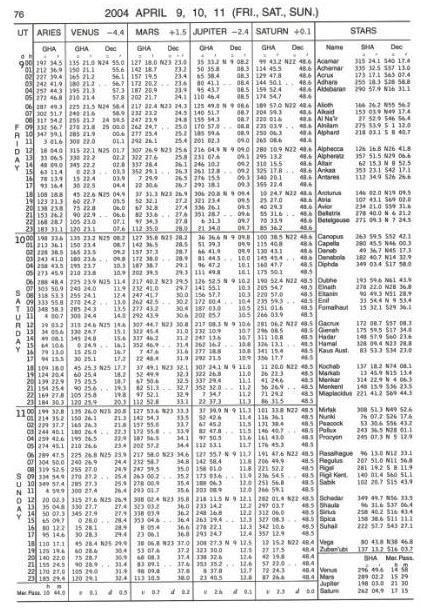
13 13
 for each whole hour UT of Aries (explained later), the GHA and Declination of the navigational planets, and alphabetically lists data for")
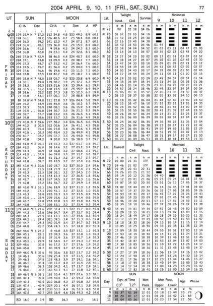
14 These pages are called the Daily pages. Note that 3 days are covered across both the left and right-hand daily pages. The left-hand daily page tabulates Greenwich Hour Angle (GHA) for each whole hour UT of Aries (explained later), the GHA and Declination of the navigational planets, and alphabetically lists data for 57 navigational stars. GHA is the hourly longitudinal position of the celestial bodies measured westerly from the Greenwich Meridian through 360. The bottom of the left-hand page also shows the time of local time zone central meridian passage of Aries and the planets, and the v and d values used to determine small corrections to be applied to your sight based on minutes and seconds of your sight time. The right-hand daily page tabulates hourly UT data for the Sun and Moon and solar phenomena of Twilight times, Sunrise, Sunset, Moonrise, and Moonset at various latitudes. On the lower right of the right-hand page the Equation of Time (shaded if the apparent Sun is later than the mean Sun, clear otherwise), Time of the Sun s meridian passage (noon at your local time zone s central meridian), and Moon data are listed for each of the three days covered. This 3 day UT hourly tabulated format continues throughout the entire year of the almanac. Mariners may take sextant sightings at any convenient time, not just on the hour. So, the almanac also contains a set of Increments and Corrections pages (pages ii to xxxi) (not available in the online almanac) near the back of the almanac. These pages list the incremental change in GHA for Sun & Planets, Aries, and Moon for each second of each minute within an hour. Also listed within each minute are the v or d corr which are small corrections to GHA (v) and declination (d) that may be required to be applied to your sextant sighting. The Increments and Corrections pages remain unchanged year to year and are the same regardless of the edition of the almanac you may have. Twilight times are periods of incomplete darkness when it may be possible to view stars and planets and still be able to discern the horizon. The midpoint for optimal sights of the stars and planets is the beginning of Civil Twilight in the morning and the end of Civil Twilight in the evening. The Nautical Almanac contains a plethora of other celestial related data and you can learn much by browsing but, that is another topic and will not be covered here. Celestial Bodies and Their Geographical Position (GP) The Celestial Sphere The mariner s view of the cosmos for celestial navigation imagines a huge transparent celestial sphere, like a bubble, with the Earth at its center as shown in the figure at right. The celestial sphere is our star map where the fixed stars and moving planets are mapped on the inside of this sphere like a planetarium. We realize that the stars and planets have a threedimensional location in space, but for the purposes of navigation, we only need to know their direction and altitude in the sky. We are located on the Earth s surface inside of the sphere looking out. The celestial sphere has an equatorial plane called the Celestial Equator, it is the Earth s 14


15 equator projected outward onto the sphere. The Earth s poles are also extended to the sphere as north and south celestial poles. The sphere does not spin. It is fixed in space while the Earth rotates inside it. When we take a sextant sight of a celestial body to measure the altitude of the body, we imagine a line passing through our body, head to toe, extending to the celestial sphere. The spot directly over our head on the sphere is called the zenith and the spot directly below our feet is the nadir. This, along with the horizon, aids us in creating a triangle that we can use to determine other values. The figure at right depicts a 2D graphical representation of a sextant sight. Note the Zenith to Horizon angle is 90 and the Observed Altitude measured plus the Co- Altitude span the entire 90. We record the sextant observation data and the Co-Altitude tells us the distance from the GP of the body. For example, if we measured an observed altitude of 50, the Co-Altitude would be = 40 and 40 at 60 nm per degree = 2400 nm distant from the Geographical Position (GP) of the body. Again, the Geographical Position of the body is a point on the Earth s surface where a line connecting the Earths center to the celestial body passes through the Earth s surface. What is Aries, and How Does It Relate to Celestial Bodies? The Seasons Each year as the Earth revolves around the Sun we experience the four seasons. Each season begins at the time of either an equinox or a solstice. A solstice begins the Northern Hemisphere summer ~June 21 st when the declination of the Sun s GP is ~23.5 north of the equator at the Tropic of Cancer. Another solstice begins the Northern Hemisphere winter ~December 21 st when the declination of the Sun s GP is ~23.5 south of the equator at the Tropic of Capricorn. Equinoxes begin the Northern Hemisphere spring and fall when the declination of the Sun s GP is at 0.0 on the equator. The Vernal Equinox occurs ~ March 21 st and the Autumnal Equinox occurs ~ September 21 st each year. Again, because the Earth s actual movement is not constant, dates of solstices and equinoxes may vary between the 20 th to the 22 nd of the months indicated. Return to page 14 and take another look at the image of the Celestial Sphere. Now imagine in your mind s eye, the stars on the sphere as if you were viewing a planetarium and gazing at a sky full of stars. From Earth, the stars appear fixed in position on the sphere which is why you can see the same constellations year after year that move as the Earth rotates. With the planetarium image in mind think of how you might identify the precise location of each visible star in the sky. Based on your learning so far you might think of measuring GHA and Declination as we did with the Sun and planets and you would be correct! Now think again, how many stars do you 15
16 see? Imagine if you will, compiling an almanac with a column for each star recording the GHA & Declination for each hour of each day for a year. How many columns would it have and how many pages long would it be? Could you conveniently carry it around? The solution to this dilemma is straightforward. Because the stars seem fixed in the sky, we choose a single start point on the sphere and measure each star s longitudinal position from that point and measure each star s declination above or below the Celestial Equator normally. But what start point do we use? Enter Aries or also called the First Point of Aries! Aries is the Vernal Equinox (March) when the Sun s GP is on the equator and the Sun s declination is 0.0, projected onto the celestial sphere. It is used by the creators of the almanac as the start (zero) point to measure each star s longitudinal position on the sphere. The longitudinal position, from Aries to each star is called the star s Sidereal Hour Angle (SHA). Each star s declination north or south of the celestial equator has been measured and recorded normally. Declination of each star changes very slowly over time eliminating the need to record declination for each hour. If you select a star from the list on a left-hand page of the almanac for a specific date then look for that star s declination in later pages you ll see the slow declination change for yourself. Open your almanac to any date daily page and look on the right side of the left-hand page. Here you ll find an alphabetical listing of 57 stars chosen for navigation due to their distribution across the sky and their brightness making them visible to the naked eye. Note that each star listed has a SHA and declination recorded. Also, on the left side of the left-hand page is a column showing GHA Aries. There is no declination recorded because Aries is not a visible body and is always on the equator. The GHA of a star is found using the formula GHA Star = GHA Aries + SHA star (±360 as may be necessary). Here s how that is accomplished. A sextant sighting is taken of the star Deneb on February 12, 2017, at from a DR position of N W. What would be Deneb s GHA? First, convert Feb to UT. The time zone of Lo W becomes / 15 = rounded to 8. The DR is west of Greenwich so 8 hours must be added to get UT becomes Feb. There is no hour 26 so, subtract 24 hours and add 1 day; the UT is Feb. From the almanac, for 13 Feb extract the SHA Deneb of and for hour 02, add GHA Aries of then add to that from the Aries column of the Increments and Corrections page for minute 0 second 30. The Total GHA becomes Deneb s longitudinal position at on 13 Feb is west of the Greenwich meridian at a declination (latitude) of N. We have precisely located the GP of Deneb at the time of the sextant sight. The Navigational Triangle: Possible Orientations Now take a closer look at the navigational triangle to gain a better understanding. The navigational triangle can have different orientations based on whether the DR is in the Northern or Southern Hemisphere and whether the celestial body viewed is east or west of the DR, as shown in the figures below. The orientation will determine the correct method of determining the true azimuth (Zn) from the DR to the GP based on the result of the Law of Cosines formula for angle Z. 16


17 North Latitude In North latitude, the azimuth Zn is determined by either Zn = Z or Zn = Z depending upon whether the GP is west of the observer when LHA is < 180 or east of the observer when LHA is > 180. The azimuth Z is labeled N XXX.X W when the latitude of the DR is north and the GP lies west of the DR or N XXX.X E when the latitude of the DR is north and the GP lies east of the DR. South Latitude In South latitude, the azimuth Zn is determined by either Zn = Z or Zn = Z depending upon whether the GP is west of the observer when LHA is < 180 or east of the observer when LHA is > 180. The azimuth Z is labeled S XXX.X W when the DR latitude is south and the GP lies west of the DR or S XXX.X E when the DR latitude is south and the GP lies east of the DR. The Navigational Triangle: Solving for Unknowns - the Law of Cosines A Sighting of the Sun at Meridian Passage or Transit A Noon Sight for Latitude When taking a sextant sighting, a mariner collects and records data about the sighting for later solving of the navigational triangle, called Sight Reduction, to obtain position data. The data 17

 is 01.5 off the arc. There is no watch error. Let us first dissect this example.")
18 recorded must be organized and categorized properly so, the mariner typically uses a Sight Reduction form. You can find one for download to follow along here SR-96A 3. Here s how a sight is recorded and solved. Example #1: On January 5, 2017, from a DR position of N W at watch time a sight is taken on the lower limb of the Sun and a sextant altitude (Hs) of is measured. The height of eye above sea level is 15 feet; sextant Index Error (IE) is 01.5 off the arc. There is no watch error. Let us first dissect this example. The Sun is large and appears (when viewed using sextant Sun shades!) as a disk. To measure the altitude using a sextant, the operator must view the Sun and, using the sextant moveable arm (index arm), bring the reflected Sun down to the horizon such that either the bottom edge (Lower Limb) or top edge (Upper Limb) just touches on the visible horizon as shown at right. At that moment, the operator calls Mark and an assistant records the watch time: seconds first, then minutes, then hours. The watch used may be fast or slow (determined beforehand) and if it is, watch error is also recorded. The observer then reads the sextant and records the altitude measured and the limb aligned (LL or UL). When taking a sextant sight, the height of your eyes will be above sea level by your height plus the height of the platform upon which you are standing. The higher your eyes, the farther away the horizon appears. We must account for this horizon error, called Dip of the Horizon or just Dip for short. On the right-hand side of page A2 of the almanac is a Dip table that shows the correction required for various heights. Find the values that bracket your height of eye and record the value shown. Or calculate it yourself using the formula: Dip correction = 0.97* height in feet. For example, if the height of your eye is 15 feet: the square root of 15 is 3.87; multiplied by 0.97 is 3.75 rounded to 3.8. Dip correction is always negative and subtracts from your sextant measurement. Also, sextants (particularly plastic sextants) may have Index Error. Index error is determined beforehand by setting the sextant to and sighting the horizon then adjusting the micrometer drum such that both the viewed and reflected horizons align as shown at right. The sextant reading is the index error. The reading may be above zero (on the arc) or below zero (off the arc (60 reading)). If it is on the arc that amount must be subtracted from the sextant reading, if it is off the arc, add that amount to the sextant reading. Now, back to the example: On January 5, 2017, from a DR position of N W at watch time a sight is taken on the lower limb of the Sun and a sextant altitude (Hs) of is measured. The height of eye above sea level is 15 feet; sextant Index Error (IE) is 01.5 off the arc. There is no watch error
19 Step 1: The observed sight: Record the date, time, watch error, the DR, the name of the body observed, the height of eye above sea level, the sextant measurement (Hs), and Index Error. Next, determine the observed altitude (Ho) of the sighting. That is done by first applying the Index Correction (IC) to the sextant measurement (Hs). IC is the opposite of IE; added if off the arc or subtracted if on the arc. Next, apply the Dip correction for the height of the eye horizon error. The result is called our apparent altitude (Ha). Using the Ha as the entering argument, enter the ALTITUDE CORRECTION TABLES SUN, STARS, PLANETS on page A2 of the almanac or the ALTITUDE CORRECTION TABLES SUN, STARS, PLANETS on page A3 of the almanac. Follow down the column until Ha values are found that bracket the Ha value and extract the Main correction to add to Ha, if positive, or subtract from Ha, if negative. This main correction corrects for semi-diameter (we sighted the edge (LL or UL)), parallax, and refraction errors caused by viewing the celestial body through Earth s atmosphere. The resulting value is the observed altitude (Ho) and now the observed sighting is completed. The figure at right shows the Observed Sight data as recorded on the sight reduction form. Again, the process for determining the observed altitude (Ho) value is: Measure and record Hs using the sextant, correct Hs for IC & Dip to obtain Ha, extract the appropriate almanac correction based on Ha, and adding (if LL was sighted) or subtracting (if UL was sighted) the main correction to Ha to obtain the resulting Ho. Step 2: The calculated sight: Called Sight Reduction. This is done by first selecting a reference position, latitude and longitude. Many celestial navigation texts refer to this location as an Assumed Position but that is a misnomer, we are not assuming we are located there. It is just a location in our vicinity that is used as a reference. Typically the DR position is used, however, any location within 30 of our DR will work. The reference position along with data extracted from the almanac about the celestial body is used to construct a Navigational Triangle. We ll not actually create the triangle the scientific calculator will do that for us as we solve the Law of Cosines formula. The formula will calculate the altitude of the celestial body that would have measured if we were actually located at the reference position at the time of the sighting. Once we have calculated the altitude (Hc), we compare the altitude we observed (Ho) to the altitude calculated (Hc) to find the difference. The resulting difference tells us how far our location at the time of the sight was offset from the reference position but not the direction. Using the second Law of Cosines formula, the azimuth Z from the reference position to the GP of the body is calculated. The two Law of Cosines formulas are shown below. As can be seen in the 1 st formula, the LHA, latitude of the reference position, and Declination are used to find the value of Hc. In the 2 nd formula, declination, latitude, and Hc are used to solve for 19
20 angle Z. To solve the Calculated Sight local time must be converted to UT, LHA determined from longitude and GHA data from the almanac, and declination data extracted from the almanac. The following figures show a completed Sight Reduction form SR-96a for the example. Step 1: The observed sight: At the time of the sighting, record the precise date and time of the sight and any watch error, the Sight Data as shown, the Altitude Hs measured, the height of eye, and index correction. Then apply IC and Dip corrections to Hs to arrive at Ha. Use the Ha value and enter the almanac (page A2) to find the Main correction and apply to Ha to obtain Ho. Step 2: The calculated sight: Convert the local time of the sight to UT for extracting almanac data to locate the GP of the celestial body at the time of the sight. Open the almanac to the date of the sight and extract the GHA of the body at the whole hour of UT. Using the minutes and seconds of the sight, enter the Increments and Corrections pages and extract the appropriate change in GHA corresponding to the minutes and seconds and add that to the whole hour GHA extracted earlier to arrive at Total GHA. Then combine the Total GHA with the reference position longitude (subtract if west, add if east (± 360 if necessary)) to determine Local Hour Angle (LHA). Return to the daily page and extract the declination (N or S) of the body at the whole hour and the d value at the bottom of the column. Record the whole hour declination and return to the same minutes and seconds page of the Increments and Corrections pages used earlier. In the v or d corr column find the d value taken from the daily page and extract the correction from the corr column. We need to know if this correction is added or subtracted. Return to the daily page and look at the declination of the body for the next whole hour of UT. If the declination is increasing, either further N or further S, add the correction, otherwise, subtract the correction to arrive at Total Declination. The LHA depicts the longitudinal position of the GP relative to the reference position longitude and the Total Declination depicts the latitude of the GP at the time of the sight. We now have the values required for solving the Law of Cosines formulas. This example shows a noon sight (also called 20


21 Meridian Transit) and you may have noticed that the Navigational Triangle has collapsed. The LHA of places the GP of the Sun only 0.3 from our longitude. For all intents, the elevated pole, our reference position, and the GP of the Sun are all on the same meridian of longitude! We have a straight N-S line, not a triangle. That s OK, we can still solve, in fact, it makes it easier to solve. The results (bottom portion of the SR-96a) for the example are shown below. Note that we convert the values of LHA, Latitude, and Declination to 5-decimal place decimal degrees for accuracy before inserting the values into the formulas. Note the true azimuth (DR to GP) Zn is 180 True. Compare the reference position latitude to the Sun s declination and knowing that they are positioned on the same meridian an azimuth of 180 should make sense. The Sun is directly south of the reference position. Also, compare the values of Ho and Hc. In this case, Ho > Hc by 1.1 and is labeled TOWARD. This means that at the time of the sight we were located 1.1 (nm) closer to the GP than the reference position is located. A Star Sight How do we solve a star sighting? Let s continue with the Deneb example from above. Example #2: A sextant sighting is taken of the star Deneb on February 12, 2017, at from a DR position of N W. Sextant altitude is ; height of eye is 15 feet; IE is 01.5 off the arc; there is no watch error. At right is the SR-96a: Apply the Dip of -3.8 and our IC of
22 to Hs of to arrive at a Ha of Turn to page A2 of the almanac using Ha as the entering argument in the STARS AND PLANETS column and extract the main correction of -2.0 and apply that correction to Ha to arrive at a Ho of Record SHA Deneb, GHA Aries, and the correction to Aries for 30 seconds as we did above for a Total GHA of Then combine Total GHA with the reference position longitude (subtract if west; add if east) for an LHA of Record the declination of Deneb of N from the daily page (there is no v or d correction for stars). Now execute the Law of Cosines formulas, as shown below, to arrive at angle Z of N 50.2 W yielding a Zn of 310 True (360 - Z) and Hc of The intercept (comparing Ho to Hc) is 1.8 nm Toward (Ho > Hc). Plot the reference position and then mark the Estimated Position along Zn at a point 1.8 nm toward the GP from the reference position. To plot a fix of position we would need to take a sight on a second celestial body (~30 or greater separating the two (90 ideal)) within 20 minutes of our 1 st sight and solve and plot both results to obtain a fix. The Planets Unlike the fixed stars, the planets move among the stars throughout the year. This makes locating planets that may be visible for sights a bit more challenging. The chart on page 9 of the almanac shows the LOCAL MEAN TIME OF MERIDIAN PASSAGE of the planets throughout the year. The narrative on page 8 is helpful in deciphering the chart. To interpret the chart, for the Northern Hemisphere (turn the chart upside down for the Southern Hemisphere and directions are opposite), is to set the (2017) almanac in front of you in portrait orientation (have the sun shaded area going directly away from you; you are facing south); East is to the left and West is to the right. Now imagine it is noon on the 20th of July. From the chart, you can see that Venus is to the right (west) of the Sun so it sets before the Sun and therefore will not available at evening twilight but may be available at morning twilight as it rises before the Sun. Jupiter is East of the Sun so it sets well after the Sun as it crosses your meridian at ~1700, five hours (75 ) after the Sun so will be available at evening twilight in the SW. Saturn is also East of the Sun (and East of Jupiter) and crosses your meridian ~2145 so it may be available at evening twilight to the SE as it is well after the Sun. If you could roll this diagram into a tube along the Sun axis, and rotate it westerly, the planet actions become even easier to imagine. 22
 and can eliminate the possibility of confusion of the sight between")
23 Note that Mercury is shown on the chart but is too close to the Sun most of the time to be of use to the navigator. It is included in the chart so the navigator can determine when it is in conjunction with other planets (where their tracks cross) and can eliminate the possibility of confusion of the sight between Mercury and the planet of interest. Another way to help locate planets is to use the SHA and LMT of meridian passage of each planet that is shown on the lower right of the left-hand daily page of the almanac. Planets whose meridian passage time is more than an hour away from the Sun s meridian passage time are potentially visible during morning or evening twilight. If a planet s meridian passage is earlier than the Sun s, the planet will set ahead of the Sun and will not be visible after sunset but may be available before sunrise. If a planet s meridian passage is near midnight it rises near sunset and will be visible all night. The altitude of the planet (any celestial body) is a function of (the planet s) declination and your latitude. Altitude at meridian passage (Transit) can be predicted with the following formula: Altitude at MT = Co-Latitude ± Declination Where Co-Latitude is 90 - your latitude and declination are added if declination and co-latitude have the same name (both north or both south), subtracted otherwise. Co-Latitude is north if the body s GP is south of the observer. Knowing this altitude can assist you in estimating when the planet will rise or set and whether it may be available for morning or evening twilight. Here s an example of a planet sight. Example #3 On February 15, 2017, from a DR position of N W at , a sight of Mars is taken. The height of the eye is 15 feet; IE is 01.5 off the arc; Hs is ; there is no watch error. Here s the completed SR-96a: To increase your proficiency, print a blank SR-96a and, using an almanac and following the details shown in previous examples, try solving this sight. It s fine if you need to refer back often, just give it a try. If you do not have a current almanac, you can use the one you have for practice, keeping in mind the extracted data will not match precisely. Here s the Mars Sight Reduction solution: 23

24 You may also find it interesting to note the mathematical relationship of sines to cosines used by the formulas. We learned in the Navigational Triangle that we are solving for the Co-H side, yet the 1 st formula results in the Sine of Hc. In the solution above, Hc is or The Co- Altitude (Co-H) is then = Use your calculator cosine function to find the cos( ) and store the result. Now use your calculator s sin -1 (ASin) function and using the cosine stored, find the resultant angle, sin -1 (cosine ). Did you get (Hc) ? The sine of an angle is equal to the cosine of the angle s complement! Sine = cosine The formula really has solved for the cosine of Co-H but used the sin -1 function to find its Hc complement. Summary There are many topics and details to learn in order to solve for a position using Celestial Navigation however, they are not particularly difficult to learn and apply with a bit of persistence on your part. Perhaps the easiest part of learning Celestial Navigation is the use of a sextant to take the observed sight. Using the instruction manual, a friend with the knowledge, or by watching a YouTube video, and practicing, in less than an hour you ll be well on your way to becoming proficient! The difficulty of celestial lies in the details of creating and solving the reference or calculated sight using data extracted from the Nautical Almanac, and the Law of Cosines formulas. Using a sextant and the Law of Cosines formulas enables you to purchase and carry no more than a current Nautical Almanac and a scientific calculator. There is no need to purchase and carry volumes of tabulated, pre-calculated navigational triangle solutions used for sight reduction such as Pub (formerly H.O.) Sight Reduction Tables for Marine Navigation or Pub (formerly H.O.) Sight Reduction Tables for Air Navigation. 24
CHAPTER 20 SIGHT REDUCTION
 CHAPTER 20 SIGHT REDUCTION BASIC PRINCIPLES 2000. Introduction Reducing a celestial sight to obtain a line of position consists of six steps: 1. Correcting sextant altitude (hs) to obtain observed altitude
CHAPTER 19 SIGHT REDUCTION
 CHAPTER 19 SIGHT REDUCTION BASIC PROCEDURES 1900. Computer Sight Reduction The purely mathematical process of sight reduction is an ideal candidate for computerization, and a number of different hand-held
Complete Sun Sight Reduction Procedure
 Caution...2 Usage...2 Conventions...2 Assumptions...2 Explanation...2 Sight #...2 DR Latitude/DR Longitude...2 Date...2 GMT/UT...3 Hs...3 D. R. I. P. S...3 Index Error...3 Complete Sun Sight Reduction
ASTRONOMICAL NAVIGATION
 Basic terms ASTRONOMICAL NAVIGATION *astronomical navigation *compilation *astronomical tabels *celestial observations *solution of a sight * Sun/Moon/star sight *spherical trigonometry *PZX triangle *celestial
CELESTIAL COORDINATES
 ASTR 1030 Astronomy Lab 27 Celestial Coordinates CELESTIAL COORDINATES GEOGRAPHIC COORDINATES The Earth's geographic coordinate system is familiar to everyone - the north and south poles are defined by
Navigating by the Stars and Planets
 Navigating by the Stars and Planets (Finding your location from measured altitudes of celestial bodies) Presented to: Chagrin Valley Astronomical Society September 1, 2012 By Ron Baker, CVAS member Historical
Understanding Celestial Navigation
 Understanding Celestial Navigation By Ron Davidson, SN Poverty Bay Sail & Power Squadron I grew up on the Jersey Shore very near the entrance to New York harbor and was fascinated by the comings and goings
NAVIGATION THEORY QUESTIONS Basics of Navigation
 NAVIGATION THEORY QUESTIONS Basics of Navigation Q610065 look at it The angle between the plane of the ecliptic and the plane of equator is approx? 23.5 degrees In which two months of the year is the difference
DUMMIES guide to Astro-Navigation
 DUMMIES guide to Astro-Navigation The idea of this booklet is to give you the nuts and bolts in the process of gaining a position on your chart through celestial navigation without a deep understanding
INTRODUCTION FOREWORD
 FOREWORD The Sight Reduction Tables for Air Navigation consist of three volumes of comprehensive tables of altitude and azimuth designed for the rapid reduction of astronomical sights in the air. This
4 Solar System and Time
 4 olar ystem and Time 4.1 The Universe 4.1.1 Introduction The Universe consists of countless galaxies distributed throughout space. The bodies used in astro navigation belong to the Galaxy known as the
AFPAM MARCH Chapter 8 CELESTIAL CONCEPTS
 AFPAM11-216 1 MARCH 2001 197 Section 8A Introduction to Celestial Concepts Chapter 8 CELESTIAL CONCEPTS 8.1. Basics. Celestial navigation is a universal aid to dead reckoning (DR). Because it is available
Understanding Positional Astronomy Part 2 Celestial Co-ordinates Difficulty: Intermediate
 Exercise: Understanding Positional Astronomy Part 2 Celestial Co-ordinates Difficulty: Intermediate Objectives In Part 1 you learned about Celestial Sphere and how the stars appear to move across the night
Chapter 6: Latitude by Noon Sight
 Chapter 6: Latitude by oon ight When the sun is crossing the meridian of the boat, it is straight south or north of the boat and at its highest altitude over the horizon for the day. The local meridian
Astro Navigation (i.e. Celestial Navigation)
") Name: Partner First Name: Astro Navigation (i.e. Celestial Navigation) Over the course of human lifetimes, the stars don t appear to change positions much. We can use that in order to determine locations
Name: Partner First Name: Astro Navigation (i.e. Celestial Navigation) Over the course of human lifetimes, the stars don t appear to change positions much. We can use that in order to determine locations
Chapter 2 Lecture. The Cosmic Perspective Seventh Edition. Discovering the Universe for Yourself
 Chapter 2 Lecture The Cosmic Perspective Seventh Edition Discovering the Universe for Yourself Discovering the Universe for Yourself 2.1 Patterns in the Night Sky Our goals for learning: What does the
Introduction To Modern Astronomy I: Solar System
 ASTR 111 003 Fall 2007 Lecture 02 Sep. 10, 2007 Introduction To Modern Astronomy I: Solar System Introducing Astronomy (chap. 1-6) Planets and Moons (chap. 7-15) Chap. 16: Our Sun Chap. 28: Search for
2. Modern: A constellation is a region in the sky. Every object in the sky, whether we can see it or not, is part of a constellation.
 6/14 10. Star Cluster size about 10 14 to 10 17 m importance: where stars are born composed of stars. 11. Galaxy size about 10 21 m importance: provide a stable environment for stars. Composed of stars.
6/17. Universe from Smallest to Largest:
 6/17 Universe from Smallest to Largest: 1. Quarks and Leptons fundamental building blocks of the universe size about 0 (?) importance: quarks combine together to form neutrons and protons. One of the leptons
Chapter S1 Lecture. The Cosmic Perspective Seventh Edition. Celestial Timekeeping and Navigation Pearson Education, Inc.
 Chapter S1 Lecture The Cosmic Perspective Seventh Edition Celestial Timekeeping and Navigation 2014 Pearson Education, Inc. Celestial Timekeeping and Navigation 2014 Pearson Education, Inc. S1.1 Astronomical
Oberth: Energy vs. Momentum
 1 2 The Oberth Effect 3 Oberth: Energy vs. Momentum 4 The Celestial Sphere From our perspective on Earth the stars appear embedded on a distant 2-dimensional surface the Celestial Sphere. 5 The Celestial
Venus Project Book, the Galileo Project, GEAR
 1 Venus Project Book, the Galileo Project, GEAR Jeffrey La Favre November, 2013 Updated March 31, 2016 You have already learned about Galileo and his telescope. Recall that he built his first telescopes
Workforms. contents. Note on copyright and reproduction
 Workforms contents Form 104 for Sight Reduction with Pub. 249 or 229 Form 106 for Sight Reduction with NAO Tables Form 107 for LAN Sights Form 108 Combined Sight Reduction Form 109 for Solar Index Correction
Discovering the Night Sky
 Discovering the Night Sky Guiding Questions 1. What role did astronomy play in ancient civilizations? 2. Are the stars that make up a constellation actually close to one another? 3. Are the same stars
Discovering the Night Sky
 Guiding Questions Discovering the Night Sky 1. What role did astronomy play in ancient civilizations? 2. Are the stars that make up a constellation actually close to one another? 3. Are the same stars
Fundamentals of Satellite technology
 Fundamentals of Satellite technology Prepared by A.Kaviyarasu Assistant Professor Department of Aerospace Engineering Madras Institute Of Technology Chromepet, Chennai Orbital Plane All of the planets,
ClassAction: Coordinates and Motions Module Instructor s Manual
 ClassAction: Coordinates and Motions Module Instructor s Manual Table of Contents Section 1: Warm-up Questions...3 The Sun s Path 1 4 Section 2: General Questions...5 Sledding or Going to the Beach...6
Chapter S1 Celestial Timekeeping and Navigation. How do we define the day, month, year, and planetary time periods?
 Chapter S1 Celestial Timekeeping and Navigation S1.1 Astronomical Time Periods Our goals for learning:! How do we define the day, month, year, and planetary time periods?! How do we tell the time of day?!
Chapter 2. Altitude Measurement
 Chapter Altitude Measurement Although altitudes and zenith distances are equally suitable for navigational calculations, most formulas are traditionally based upon altitudes which are easily accessible
Cartesian Coordinates Need two dimensional system 2 number lines perpendicular to each other X-axis is horizontal Y-axis is vertical Position relative
 General Physical Science Chapter 15 Place and Time Space and Time Einstein Space and time related Single entity Time is the 4 th dimension! Cartesian Coordinates Need some system to tell us where something
Knowing the Heavens. Chapter Two. Guiding Questions. Naked-eye (unaided-eye) astronomy had an important place in ancient civilizations
 astronomy had an important place in ancient civilizations") Knowing the Heavens Chapter Two Guiding Questions 1. What role did astronomy play in ancient civilizations? 2. Are the stars that make up a constellation actually close to one another? 3. Are the same
Knowing the Heavens Chapter Two Guiding Questions 1. What role did astronomy play in ancient civilizations? 2. Are the stars that make up a constellation actually close to one another? 3. Are the same
SUN SIGHT REDUCTION CALCULATIONS
 SUN SIGHT REDUCTION CALCULATIONS Date: Ship s time: GMT at sight: h m s DR Position: Lat º N/S Long º E/W Ass Position: Lat º N/S Long º E/W GHA: º Decl: º N/S d = +/- Incrmnt º Corr: +/- GHA: º Decl:
Meridian Circle through Zenith, North Celestial Pole, Zenith Direction Straight Up from Observer. South Celestial Pole
 Chapter 3 How Earth and Sky Work- Effects of Latitude In chapters 3 and 4we will learn why our view of the heavens depends on our position on the Earth, the time of day, and the day of the year. We will
The Earth is a Rotating Sphere
 The Earth is a Rotating Sphere The Shape of the Earth Earth s Rotation ( and relative movement of the Sun and Moon) The Geographic Grid Map Projections Global Time The Earth s Revolution around the Sun
Celestial Sphere Spectroscopy (Something interesting; e.g., advanced data analyses with IDL)
") AST326, 2010 Winter Semester Celestial Sphere Spectroscopy (Something interesting; e.g., advanced data analyses with IDL) Practical Assignment: analyses of Keck spectroscopic data from the instructor (can
AST326, 2010 Winter Semester Celestial Sphere Spectroscopy (Something interesting; e.g., advanced data analyses with IDL) Practical Assignment: analyses of Keck spectroscopic data from the instructor (can
Chapter 1: Discovering the Night Sky. The sky is divided into 88 unequal areas that we call constellations.
 Chapter 1: Discovering the Night Sky Constellations: Recognizable patterns of the brighter stars that have been derived from ancient legends. Different cultures have associated the patterns with their
UNIT 6 CELESTIAL SPHERE AND EQUINOCTIAL SYSTEM OF COORDINATES
 UNIT 6 CELESTIAL SPHERE AND EQUINOCTIAL SYSTEM OF COORDINATES Structure 6.1 Introduction Objectives 6.2 References 6.3 Apparent Annual Motion of the Sun and the Concept of the Ecliptic and the Obliquity
5 - Seasons. Figure 1 shows two pictures of the Sun taken six months apart with the same camera, at the same time of the day, from the same location.
 ASTR 110L 5 - Seasons Purpose: To plot the distance of the Earth from the Sun over one year and to use the celestial sphere to understand the cause of the seasons. What do you think? Write answers to questions
Exercise 7.0 THE CHANGING DIURNAL CIRCLES OF THE SUN
 Exercise 7.0 THE CHANGING DIURNAL CIRCLES OF THE SUN I. The Apparent Annual Motion of the Sun A star always rises and sets at the same place on the horizon and, hence, it is above the horizon for the same
THE EARTH AND ITS REPRESENTATION
 UNIT 7 THE EARTH AND ITS REPRESENTATION TABLE OF CONTENTS 1 THE EARTH AND THE SOLAR SYSTEM... 2 2 THE EARTH S MOVEMENTS... 2 2.1 Rotation.... 2 2.2 The revolution of the Earth: seasons of the year....
The celestial sphere, the coordinates system, seasons, phases of the moon and eclipses. Chapters 2 and S1
 The celestial sphere, the coordinates system, seasons, phases of the moon and eclipses Chapters 2 and S1 The celestial sphere and the coordinates system Chapter S1 How to find our way in the sky? Let s
Earth Motions Packet 14
 Earth Motions Packet 14 Your Name Group Members Score Minutes Standard 4 Key Idea 1 Performance Indicator 1.1 Explain complex phenomena, such as tides, variations in day length, solar insolation, apparent
Lesson 20: The Earth in its Orbit
 291 Lesson 20: The Earth in its Orbit Recall that the Earth s orbit around the un is an ellipse which is almost a perfect circle. The average distance from the un to the Earth is 152,100,000 km (to the
National Maritime Center
 National Maritime Center Providing Credentials to Mariners Q127 Navigation Problems-Oceans (Sample Examination) Page 1 of 5 Choose the best answer to the following Multiple Choice questions. 1. You depart
Chapter 2 Discovering the Universe for Yourself. Copyright 2012 Pearson Education, Inc.
 Chapter 2 Discovering the Universe for Yourself 1 2.1 Patterns in the Night Sky Our goals for learning: What does the universe look like from Earth? Why do stars rise and set? Why do the constellations
Name: Date: 5. The bright stars Vega, Deneb, and Altair form A) the summer triangle. B) the winter triangle. C) the Big Dipper. D) Orion, the Hunter.
 the summer triangle. B) the winter triangle. C) the Big Dipper. D) Orion, the Hunter.") Name: Date: 1. If there are about 6000 stars in the entire sky that can be seen by the unaided human eye, about how many stars would be seen at a particular instant on a given dark night from a single
Name: Date: 1. If there are about 6000 stars in the entire sky that can be seen by the unaided human eye, about how many stars would be seen at a particular instant on a given dark night from a single
Chapter 2 Lecture. The Cosmic Perspective Seventh Edition. Discovering the Universe for Yourself Pearson Education, Inc.
 Chapter 2 Lecture The Cosmic Perspective Seventh Edition Discovering the Universe for Yourself Discovering the Universe for Yourself 2.1 Patterns in the Night Sky Our goals for learning: What does the
LOCATING CELESTIAL OBJECTS: COORDINATES AND TIME. a. understand the basic concepts needed for any astronomical coordinate system.
 UNIT 2 UNIT 2 LOCATING CELESTIAL OBJECTS: COORDINATES AND TIME Goals After mastery of this unit, you should: a. understand the basic concepts needed for any astronomical coordinate system. b. understand
For most observers on Earth, the sun rises in the eastern
 632 CHAPTER 25: EARTH, SUN, AND SEASONS WHAT IS THE SUN S APPARENT PATH ACROSS THE SKY? For most observers on Earth, the sun rises in the eastern part of the sky. The sun reaches its greatest angular altitude
Astronomy 291. Professor Bradley M. Peterson
 Astronomy 291 Professor Bradley M. Peterson The Sky As a first step, we need to understand the appearance of the sky. Important points (to be explained): The relative positions of stars remain the same
3. The Sun s Position
 3. The Sun s Position In order to understand how to collect energy from the sun, one must first be able to predict the location of the sun relative to the collection device. In this chapter we develop
Chapter 2 Discovering the Universe for Yourself. What does the universe look like from Earth? Constellations. 2.1 Patterns in the Night Sky
 Chapter 2 Discovering the Universe for Yourself 2.1 Patterns in the Night Sky Our goals for learning: What does the universe look like from Earth? Why do stars rise and set? Why do the constellations we
C) the seasonal changes in constellations viewed in the night sky D) The duration of insolation will increase and the temperature will increase.
 the seasonal changes in constellations viewed in the night sky D) The duration of insolation will increase and the temperature will increase.") 1. Which event is a direct result of Earth's revolution? A) the apparent deflection of winds B) the changing of the Moon phases C) the seasonal changes in constellations viewed in the night sky D) the
1. Which event is a direct result of Earth's revolution? A) the apparent deflection of winds B) the changing of the Moon phases C) the seasonal changes in constellations viewed in the night sky D) the
Chapter 2 Discovering the Universe for Yourself
 Chapter 2 Discovering the Universe for Yourself 2.1 Patterns in the Night Sky Our goals for learning: What does the universe look like from Earth? Why do stars rise and set? Why do the constellations we
Astronomy 122 Section 1 TR Outline. The Earth is Rotating. Question Digital Computer Laboratory
 Astronomy 122 Section 1 TR 1300-1350 Outline 1320 Digital Computer Laboratory Leslie Looney Phone: 244-3615 Email: lwlw@wuiucw. wedu Office: Astro Building #218 Office Hours: T 10:30-11:30 a.m. or by appointment
Appearance of the Sky Orientation Motion of sky Seasons Precession (?)
") Today Appearance of the Sky Orientation Motion of sky Seasons Precession (?) The Celestial Sphere Stars at different distances all appear to lie on the celestial sphere. The ecliptic is the Sun s apparent
Today Appearance of the Sky Orientation Motion of sky Seasons Precession (?) The Celestial Sphere Stars at different distances all appear to lie on the celestial sphere. The ecliptic is the Sun s apparent
Summary Sheet #1 for Astronomy Main Lesson
 Summary Sheet #1 for Astronomy Main Lesson From our perspective on earth The earth appears flat. We can see half the celestial sphere at any time. The earth s axis is always perpendicular to the equator.
National Maritime Center
 National Maritime Center Providing Credentials to Mariners (Sample Examination) Page 1 of 5 Choose the best answer to the following Multiple Choice questions. 1. On 24 July your 1912 zone time DR position
Astronomy 101: 9/18/2008
 Astronomy 101: 9/18/2008 Announcements Pick up a golf ball at the front of the class or get one from Alex; you will need it for an in-class activity today. You will also need the question sheet from Alex.
CHAPTER 24 THE SAILINGS
 CHAPTER 24 THE SAILINGS INTRODUCTION 2400. Introduction Dead reckoning involves the determination of one s present or future position by projecting the ship s course and distance run from a known position.
Geography Class 6 Chapters 3 and
 CHAPTER 3 MOTIONS OF THE EARTH The Earth is always travelling in Space. That makes each person on Earth, a Space Traveller. No one feels the movement of the Earth because humans are too tiny when compared
Altitude NAVIGATION. Visible Horizon
 Altitude Visible Horizon Rational Horizon Sensible Horizon Dip Polar Distance A small circle on the surface of the earth, containing the points of intersection between the observer s eye sight and the
Knowing the Heavens. Goals: Constellations in the Sky
 Goals: Knowing the Heavens To see how the sky changes during a night and from night to night. To measure the positions of stars in celestial coordinates. To understand the cause of the seasons. Constellations
Knowing the Heavens. Goals: Constellations in the Sky
 Goals: Knowing the Heavens To see how the sky changes during a night and from night to night. To measure the positions of stars in celestial coordinates. To understand the cause of the seasons. Constellations
LAB: What Events Mark the Beginning of Each Season?
 Name: Date: LAB: What Events Mark the Beginning of Each Season? The relationship between the Sun and Earth have been used since antiquity to measure time. The day is measured by the passage of the Sun
Appearance of the Sky Orientation Motion of sky Seasons Precession (?)
") Today Appearance of the Sky Orientation Motion of sky Seasons Precession (?) The Celestial Sphere Stars at different distances all appear to lie on the celestial sphere. The ecliptic is the Sun s apparent
Today Appearance of the Sky Orientation Motion of sky Seasons Precession (?) The Celestial Sphere Stars at different distances all appear to lie on the celestial sphere. The ecliptic is the Sun s apparent
EARTHS SHAPE AND POLARIS PRACTICE 2017
 1. In the diagram below, letters A through D represent the locations of four observers on the Earth's surface. Each observer has the same mass. 3. Which diagram most accurately shows the cross-sectional
Modern Navigation. Thomas Herring
 12.215 Modern Navigation Thomas Herring Review of Monday s Class Spherical Trigonometry Review plane trigonometry Concepts in Spherical Trigonometry Distance measures Azimuths and bearings Basic formulas:
UNIT 3: EARTH S MOTIONS
 UNIT 3: EARTH S MOTIONS After Unit 3 you should be able to: o Differentiate between rotation and revolution of the Earth o Apply the rates of rotation and revolution to basic problems o Recall the evidence
Chapter 2 Discovering the Universe for Yourself
 Chapter 2 Discovering the Universe for Yourself 2.1 Patterns in the Night Sky Our goals for learning: What does the universe look like from Earth? Why do stars rise and set? Why do the constellations we
Observing the Universe for Yourself
 Observing the Universe for Yourself Figure 6-20 Solar-System Formation What does the universe look like from Earth? With the naked eye, we can see more than 2,000 stars as well as the Milky Way. A constellation
Celestial Navigation. 6. Time Objective Greenwich Mean Time
 6. Time Celestial Navigation 6.1. Objective By the end of this section you will know more about time than you thought possible. In particular you will learn how time and longitude are related, understand
Introduction To Astronomy Lesson 1
 Introduction To Astronomy Lesson 1 Topics for this Lesson Earth Based Coordinates The Celestial Sphere and Sky Coordinates The North Star Measuring Distances on the Sky The Motion of Objects in the Sky
Astr 1050 Mon. Jan. 31, 2017
 Astr 1050 Mon. Jan. 31, 2017 Finish Ch. 2: Eclipses & Planetary Motion Seasons Angular Size formula Eclipses Planetary Motion Reading: For Today: Finish Chapter 2 For Monday: Start Chapter 3 Homework on
MOTIONS OF THE EARTH. Figure 3.1 : Inclination of the Earth s axis and the orbital plane. Figure 3.2 : Day and Night on the Earth due to rotation
 3 Let s Do Take a ball to represent the earth and a lighted candle to represent the sun. Mark a point on the ball to represent a town X. Place the ball in such a way that the town X is in darkness. Now
Astronomy 101 Lab: Seasons
 Name: Astronomy 101 Lab: Seasons Pre-Lab Assignment: In class, we've talked about the cause of the seasons. In this lab, you will use globes to study the relative positions of Earth and the Sun during
Section 2. Locating Astronomical Objects in the Night Sky What Do You See? What Do You See? Think About It. Investigate.
 Section 2 Locating Astronomical Objects in the Night Sky Section 2 Locating Astronomical Objects in the Night Sky What Do You See? What Do You See? Learning Outcomes In this section, you will Construct
Time, coordinates and how the Sun and Moon move in the sky
 Time, coordinates and how the Sun and Moon move in the sky Using the colors and magnitudes of quasars drawn from the SDSS Catalog Archive Server to distinguish quasars from stars using the light they emit
Exercise 1.0 THE CELESTIAL EQUATORIAL COORDINATE SYSTEM
 Exercise 1.0 THE CELESTIAL EQUATORIAL COORDINATE SYSTEM Equipment needed: A celestial globe showing positions of bright stars and Messier Objects. I. Introduction There are several different ways of representing
CHAPTER 2 A USER'S GUIDE TO THE SKY
 CHAPTER 2 A USER'S GUIDE TO THE SKY MULTIPLE CHOICE 1. In one way of naming stars, a letter indicates its brightness relative to the other stars in the constellation. a. English b. Arabic c. Greek d. Cyrillic
The Earth-Moon-Sun System
 chapter 7 The Earth-Moon-Sun System section 2 Time and Seasons What You ll Learn how to calculate time and date in different time zones how to distinguish rotation and revolution what causes seasons Before
CHAPTER II THE COORDINATES SYSTEM AND FORMULARIES
 CHAPTER II THE COORDINATES SYSTEM AND FORMULARIES www.loxodrome.org/ Introduction to Celestial Navigation/Chapter II THE CO-ORDINATES SYSTEMS AND FORMULARIES In previous section we had a purely geometrical
PY 124: Terrestrial Position from Celestial Observations
 The linked image cannot be displayed. The file may have been moved, renamed, or deleted. Verify that the link points to the correct file and location. The linked image cannot be displayed. The file may
astronomy A planet was viewed from Earth for several hours. The diagrams below represent the appearance of the planet at four different times.
 astronomy 2008 1. A planet was viewed from Earth for several hours. The diagrams below represent the appearance of the planet at four different times. 5. If the distance between the Earth and the Sun were
The following terms are some of the vocabulary that students should be familiar with in order to fully master this lesson.
 Lesson 211: EARTH'S SEASONS Students learn the complex geometry and planetary motions that cause Earth to have four distinct seasons. Fundamental Questions Attempting to give thorough and reasonable answers
Office 307 Breshnahan Hall Phone: ext MT3121 CELESTIAL NAVIGATION II
 MT3121 CELESTIAL NAVIGATION II Learning Objective Celestial Navigation II will cover the requirements of the 1978 STCW convention as amended in 1995. The course covers the theory and practice of navigation
It s Full of Stars! Outline. A Sky Full of Stars. Astronomy 210. lights), about how many stars can we see with
, about how many stars can we see with") Astronomy 210 Section 1 MWF 1500-1550 134 Astronomy Building Leslie Looney Phone: 244-3615 Email: lwlw@wuiucw. wedu Office: Astro Building #218 Office Hours: MTF 10:30-11:30 a.m. or by appointment This
Astronomy 210 Section 1 MWF 1500-1550 134 Astronomy Building Leslie Looney Phone: 244-3615 Email: lwlw@wuiucw. wedu Office: Astro Building #218 Office Hours: MTF 10:30-11:30 a.m. or by appointment This
Guiding Questions. Discovering the Night Sky. iclicker Qustion
 Guiding Questions Discovering the Night Sky 1 1. What methods do scientists use to expand our understanding of the universe? 2. What makes up our solar system? 3. What are the stars? Do they last forever?
Go to Click on the first animation: The north pole, observed from space
 IDS 102 The Seasons on a Planet like Earth As the Earth travels around the Sun, it moves in a giant circle 300 million kilometers across. (Well, it is actually a giant ellipse but the shape is so close
LESSON PLAN - Optimum Orientation of Solar Panels Using Soltrex Data
 LESSON PLAN - Optimum Orientation of Solar Panels Using Soltrex Data Title of Lesson: Optimum Orientation of Solar Panels Using Soltrex Data Description of class: High School physics, astronomy, or environmental
5 - Seasons. Figure 1 shows two pictures of the Sun taken six months apart with the same camera, at the same time of the day, from the same location.
 Name: Partner(s): 5 - Seasons ASTR110L Purpose: To measure the distance of the Earth from the Sun over one year and to use the celestial sphere to understand the cause of the seasons. Answer all questions
Modern Navigation. Thomas Herring
 12.215 Modern Navigation Thomas Herring Review of last Class Motion of the Earth and Sun Geometry of Earth/Sun system Astronomical coordinates Motion of the Earth around the sun Equation of Time Astronomical
National Maritime Center
 National Maritime Center Providing Credentials to Mariners Master TV to Master Less than 500 Gross Registered Tons Oceans or Near Coastal (Sample Examination) Page 1 of 5 Choose the best answer to the
National Maritime Center
 National Maritime Center Providing Credentials to Mariners (Sample Examination) Page 1 of 5 Choose the best answer to the following Multiple Choice questions. 1. On 15 October your 0300 zone time DR position
Exercise 6. Solar Panel Orientation EXERCISE OBJECTIVE DISCUSSION OUTLINE. Introduction to the importance of solar panel orientation DISCUSSION
 Exercise 6 Solar Panel Orientation EXERCISE OBJECTIVE When you have completed this exercise, you will understand how the solar illumination at any location on Earth varies over the course of a year. You
12.1. The Night Sky. Earth s Motions
 12.1 The Night Sky LEARNING TIP Skim Section 12.1. Consider information gathered from the title, headings, figures, and words in bold. What do you expect to learn in this section? Astronomy is the branch
The Motion of the Observer. in Celestial Navigation
 The Motion of the Observer in Celestial Navigation George H. Kaplan Astronomical Applications Department U.S. Naval Observatory 3450 Massachusetts Avenue NW Washington, D.C. 20392-5420 The Motion of the
ASTRO Fall 2012 LAB #2: Observing the Night Sky
 ASTRO 1050 - Fall 2012 LAB #2: Observing the Night Sky ABSTRACT Today we will be calibrating your hand as an angular measuring device, and then heading down to the planetarium to see the night sky in motion.
2. Knowing the Heavens
 2. Knowing the Heavens Ancient naked-eye astronomy Eighty-eight constellations The sky s ever-changing appearance The celestial sphere Celestial coordinates Seasons: Earth s axial tilt Precession of Earth
Chapter 4 Earth, Moon, and Sky 107
 Chapter 4 Earth, Moon, and Sky 107 planetariums around the world. Figure 4.4 Foucault s Pendulum. As Earth turns, the plane of oscillation of the Foucault pendulum shifts gradually so that over the course