PROJECT TITLE: Northwest Straits Project: Jefferson County Marine Resources Committee (Operations and Projects)
|
|
|
- Kerry Potter
- 5 years ago
- Views:
Transcription
1 County: Jefferson Grant No: SEANWS-2015-JeCoWS PROJECT TITLE: Northwest Straits Project: Jefferson County Marine Resources Committee (Operations and Projects) DELIVERABLES FOR TASK NO: Task 5 Olympia Oysters. Deliverable 5.2: Olympia oyster survey data and summary report for Discovery Bay PROGRESS REPORT: [ ] FINAL REPORT [ X ] PERIOD COVERED: Oct 1, 2016 Sept 30, 2017 DATE SUBMITTED: Oct 20, 2017 This project has been funded wholly or in part by the United States Environmental Protection Agency. The contents of this document do not necessarily reflect the views and policies of the Environmental Protection Agency, nor does mention of trade names or commercial products constitute endorsement or recommendation for use.
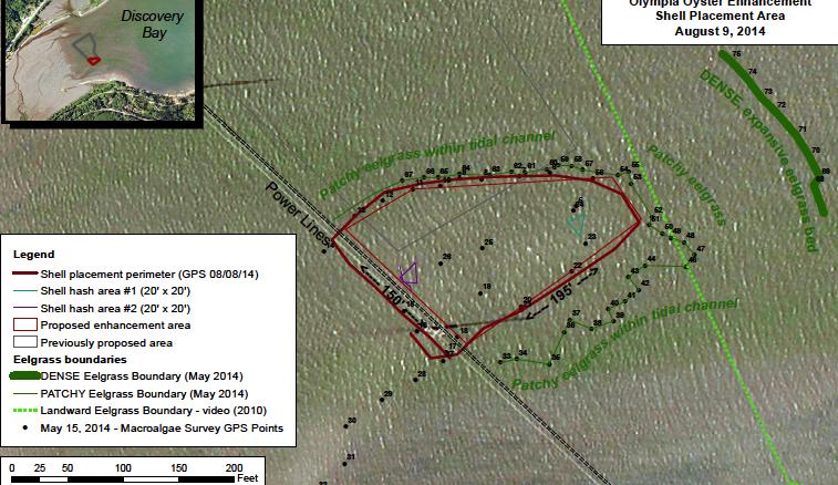
2 Olympia Oyster Survey Data & Summary Report For Discovery Bay Olympia Oyster Task 5.2 Overview & Summary Discovery Bay has a small natural Olympia oyster population near the southeast (Maynard Beach) portion of the bay. The MRC s goal is to enhance and expand that population by creating appropriate substrate (clean cultch spread on the tideflats) in nearby areas and monitoring for recruitment. We started this project in 2014 with distribution of shell within a half-acre tideflat project area surrounded by eelgrass was our third year of monitoring for Discovery Bay natural recruitment at that site. In August 2015 (during our first year of monitoring), Brady Blake, our WDFW advisor, recommended adding more unseeded cultch to the site in 2016 to bring the available shell density back up to an average of 2 shells/sq ft. Tides had moved some of the initial shell out of the project area, and some shell had settled deeper into the mud. On July 21, 2016, 13 MRC volunteers dispersed an additional 80 bags of clean cultch to the Discovery Bay site. We did not do this earlier in the year because our original permits prohibited in-water activity before July 15 th. The 2017 monitoring included cultch from both the 2014 and 2016 placements. Spat numbers and size measurements give us an indication of successful natural recruitment. A direct comparison of 2015, 2016 and 2017 data is difficult due to several factors: (1) Additions of new shell in July 2016 significantly affected how much spat was found on the cultch in August (2) As a result of several workshops and conversations with other MRCs and Olympia oyster researchers, the Jefferson MRC began collecting data on slightly different parameters to more closely align with regional Olympia oyster recovery efforts. (3) In 2017, a monitoring transect ran East-West in a location south of the original project boundary (south of the powerlines), as we had seen large numbers of Olympia oyster on shell in that area in These had to be the Pacific oyster shell we placed in 2014 that were moved south by the currents, as there was almost no substrate present on or near the project site before the MRC began its work. We also placed six shell stacks for the Puget Sound Restoration Fund (PSRF) study at this location at the end of May. Three shell stacks were placed within the 2014 Restoration Site and three were placed in the lagoons adjacent to the extant Maynard Beach population. PSRF uses this approach for measuring recruitment in order to compare results from various sites around Puget Sound. Annual monitoring took place on August 20, 2017, with four MRC volunteers and one MRC staff (Neil Harrington, Chuck Lowe, Luzi Pfeninger, Jeff Saeger and Cheryl Lowe). Shells stacks were collected on Aug 20 from both Discovery Bay sites. Monitoring data was compiled and summarized in this report. Shell stack data is being compiled in October to be sent to PSRF.
3 Data & Observations Data tables and a summary table are included in this Report, along with monitoring protocols used. A few comparisons of 2015, 2016 and 2017 Discovery Bay data are as follows: Data Collected # of quadrats monitored Average % shell cover per quadrat 5% 7% 12.4% Total # spat counted Total # of adult Olympia oysters found Each year we counted about the same number of quadrats. Significant increases in total number of Olympia oyster spat and percent cover were probably due to several factors: We placed quadrats along East-West transects this year to give us a more even distribution within the project area, as per recommendations from last year s report. More importantly, we added a transect just south of the project area to include the 2014 and 2016 cultch that had been moved there by the currents. Total spat count was much higher in 2015 than 2016, which reflects the shorter time that the 2016 shell was available for larval settlement. In 2015 and 2016, spat height was only measured as greater than or less than 15 mm (a rough estimate of reproductive maturity). In 2017, we recorded actual height to be more consistent with other regional monitoring efforts. Amy Does, the volunteer processing the six PSRF shell strings for Discovery Bay has not yet completed her work. Original data sheets are stored at the MRC office and a copy is sent to PSRF. No comparisons are provided here. Cheryl Lowe compiled the Discovery Bay data collected by the MRC monitoring team. Discovery Bay Recommendations for 2018 Continue monitoring using the East-West transects layout. Due to the uneven distribution of the shell within the original project area, it would be useful to somehow determine the approximate boundary of where the cultch is now distributed, including south of the powerlines. It could be a challenge to determine this boundary, as in 2017, the cultch was often hidden under a thin layer of green macroalgae (temporarily removed when collecting data in a quadrat) or the cultch could also be doing well in the adjacent eelgrass, which we do not want to disturb. If time allows, it also would be interesting to complete a second transect south of the power lines. Outreach and Photos A posting about the Discovery Bay monitoring appeared on the Jefferson MRC website in September.


4 Photo 1: Discovery Bay shell with many adult Olympia oysters found just outside boundary of project area.

5 Photos 2: Volunteer monitoring in August 2017.
6 Discovery Bay MRC Olympia Oyster Project SIZE & Number of SPAT Transects Measuring Ht of Olys in quadrats along 7 random transects Waterbody: Station Name: Discovery Bay DiscoBay 2014 Restoration Site Monitoring Date 20-Aug-17 7:45 am - 11 am on-site. Final clean-up completed at 12:30 pm. Time of Low tide -1.5 tide at 9 am Monitored Area (m2)? Original Project Area (m2):? Quadrats are 0.5m2 Per Transect Transect # # Quad w spat* # Quad w no shell or spat Q-Area monitored (m2) # Spat # of shells w Olys: Avg Length Avg % cover** Ave % coverallq T-A Sub-Totals * number of quadrats with Oly spat in them ** percent cover only for quadrats with shells and Oly spat
7 Olympia Oyster Monitoring--Discovery Bay 2017 Jefferson County Marine Resources Committee August 20, 2017 Protocols approved by WDFW Shellfish Biologist Brady Blake, August Goal: To monitor oyster spat set on clean Pacific oyster shells placed in August 2014 & July 2016 in a ½ acre area in lower Discovery Bay. Shell placement is to test effectiveness of a low-impact strategy to encourage natural seed set from a nearby existing Olympia Oyster population. For more details about initial work, see Jefferson MRC s Olympia oyster project report and maps. Equipment: GPS & notebook for writing notes 100 tape measure (optional) camera for quadrat pix 2 sets of data sheets (on waterproof paper), pencils, clipboards Stakes or pin flags to mark transect start, end and quadrat centers. Flagging and 20 wire flags Volunteer sign-in forms Safety review & first aid kit Gloves Mudboots Rulers with mm measure 3 5-gal buckets collect shell stacks? Random numbers for August 20, 2017: 4, 5, 9, 5, 3, 9, 4, 8, 3, tide predicted at 9 am that day. Volunteers met at 7:45 am at Hwy 101 DFW parking lot. Monitored until 11 am, when tide pushed us out. Approximate tide ht at that time was 0.0. Five volunteers in 2 teams did the monitoring. Protocols: Random numbers are used to locate the start of transects and quadrats within the project area (pace = one step of one leg). Because a number of shells have drifted south of the Powerlines (southern boundary of original project area, in 2017 we will add one transect parallel to and 6 paces south of the Powerline, 1. Use the Powerlines as the South boundary of the plot (it s actually SW edge). 2. Beginning at approximately the SE end of that boundary line (GPS lat-long ), walk North, using flags to mark a long N-S Baseline transect on the E side of the plot. This line is where all the E-W transects will start from.
8 3. Walk 4 [random number above] of paces in a N direction along the N-S Baseline to beginning point of Transect 1. Mark with a stake for beginning of Transect #1. Record the GPS coordinates for start of Transect (or record GPS end points of all transects once they are marked). 4. Walk 5 more paces along the Baseline and mark beginning of transect #2 (using stakes or wire flags). 5. Walk 9 more paces along powerline and mark beginning of transect #3. 6. Walk 5 more paces along powerline and mark beginning of transect #4. NOTE: At this point we realized we were short on time and decided to record data from more widely spaced transect to get a better idea of distribution. We skipped Transects 4 and 5. Data was collected in quadrats along T6 (#4 in database) and T8 (#5 in database). See next four items for spacing of those transects. 7. Walk 3 more paces along powerline and mark beginning of transect #5. 8. Walk 9 more paces along powerline and mark beginning of transect #6. 9. Walk 4 more paces along powerline and mark beginning of transect # Walk 8 more paces along powerline and mark beginning of transect # From each Transect starting point, facing NW in a line parallel to the powerlines. Walk a straight line out to the end of the visible shell, or when you reach the edge of the eelgrass, and put a tall, flagged stake in the mud. Record the GPS coordinates of the end point of each Transect. 12. Go back to the East starting point of Transect #1 and walk 6 [random number] of paces. Put a wire flag at that point. You will place the quadrat frames on the ground with the stake at the center and the tape (or imaginary transect line) running through the center of the quadrat. After the first wire flag, walk 5 more paces and place another wire flag/quadrat in the same orientation. Repeat to the end of the Transect # Repeat for each transect, starting at: 5 paces for #2
9 2 paces for #3 7 paces for #4 repeat this pattern of (random) 5, 2 and 7 paces to start placement of the first quadrat along each transect, keeping all the other quadrat spacing at 5 paces apart. NOTE: Again, due to limited time, we shifted to every 10 paces starting with Transect #3. NOTE: Due to the large number of Olympia oysters in Transect A (south of the powerlines) one team collected data on T-A after completing T#!, where quadrats were 5 paces apart, after starting with a random number.. Quadrat Instructions 1. For each quadrat, you will a. Rearrange shell in preparation for data collection b. Measure and record the size of each Oly spat found on each shell c. Estimate percent cover of oyster shell and take a photo Due to limited time, available cameras, and the fact that we haven t used this info in the past, we skipped the photo-taking step.) 2. Record on the data sheet the Transect # and time you start that Transect. 3. Move all the shell out of one-quarter section and then start inspecting and moving them into that first quarter section as you collect data. Pick up each shell piece and inspect it for Olympia oyster spat. Using a new column on the data sheet for each shell, record sizes of all Oly spat found on each shell. Once you have counted a shell, placed it on the ground in that first quarter section that was emptied. To estimate overall coverage, place all the counted shells with edges touching so you can easily estimate the total % cover for that quadrat. Record the % cover estimate on the data sheet at the top of the shell count for that quadrat, and take a photo (automatically time-stamped), so we can match them up (for percent cover.) Due to limited time, available cameras, and the fact that we haven t used this info in the past, we skipped the photo-taking step.) 4. Go to the next quadrat in that Transect. 5. If you have more than 3 quadrats in a Transect, start another sheet and be sure to note the Transect # at the top. 6. If there are no shells with Olys anywhere in a quadrat, then add a tally mark to # Quadrats with No Shell box at the top of the data sheet.
10 7. Repeat for each quadrat in the Transect. When you get to the end of the Transect line, make sure you have recorded the End Point on the GPS. 8. Start a new page for a new Transect.

11
PROJECT TITLE: Northwest Straits Project: Jefferson County Marine Resources Committee (Operations and Projects)
") County: Jefferson Grant No: SEANWS-2015-JeCoWS-00007 PROJECT TITLE: Northwest Straits Project: Jefferson County Marine Resources Committee (Operations and Projects) DELIVERABLES FOR TASK NO: Task 5 Olympia
County: Jefferson Grant No: SEANWS-2015-JeCoWS-00007 PROJECT TITLE: Northwest Straits Project: Jefferson County Marine Resources Committee (Operations and Projects) DELIVERABLES FOR TASK NO: Task 5 Olympia
Third Annual Monitoring Report Tidal Wetland Restoration 159 Long Neck Point Road, Darien, CT NAE
 1) Project Overview Third Annual Monitoring Report Tidal Wetland Restoration 159 Long Neck Point Road, Darien, CT NAE-2007-1130 December 15, 2014 This is the third year of a five year monitoring program
Florida Department of Environmental Protection Inspection Checklist N. SIDE OF HWY. 20-W.OF FREEPT
 Florida Department of Environmental Protection Inspection Checklist FACILITY INFORMATION: Facility Name: On-Site Inspection Start Date: On-Site Inspection End Date: 10/08/2015 WACS No.: 15091 Facility
Second Annual Monitoring Report Tidal Wetland Restoration 159 Long Neck Point Road, Darien, CT NAE
 1) Project Overview Second Annual Monitoring Report Tidal Wetland Restoration 159 Long Neck Point Road, Darien, CT NAE-2007-1130 December 13, 2013 This is the second year of a five year monitoring program
Percent cover standards
 Percent cover standards 2% 12% 20% 30% 35% 55% 75% 90% SEAGRASS SPECIES CODES ZC Zostera capricorni Hu Halodule uninervis 5 longitudinal veins Cross veins Leaf grows straight from rhizome ie no shoot trident
Quarterly Report April 1 - June 30, By: Shirley P. Dutton. Work Performed Under Contract No.: DE-FC22-95BC14936
 DE-FC22-95BC14936--18 Application of Advanced Reservoir Characterization, Simulation, and Production Optimization Strategies to Maximize Recovery in Slope, and Basin Clastic Reservoirs, West Texas (Delaware
Seagrass Percentage Cover
 Seagrass Percentage Cover 5 25 30 40 55 65 80 95 80% SEAGRASS SPECIES CODES Cs Cymodocea serrulata Serrated leaf tip Wide leaf blade (5-9mm wide) Leaves 6-15cm long 13-17 longitudinal veins Cr Cymodocea
Estimation of a Plant Density Exercise 4
 Estimation of a Plant Density Exercise 4 2011-2014 Johnson, Larson, Louhaichi, & Woerz Density from Quadrats or Plots When monitoring for ecosystem change, especially for change in rare or endangered plant
Documenting Plants & Animals in Each Habitat
 Documenting Plants & Animals in Each Habitat STEP 25: UNDERSTAND THE QUADRAT SURVEY METHOD It is not possible to count all the plants and animals in a habitat unit, since the habitat unit could be quite
Carbon Cycle Sample Site Set- up - Student Field Guide. Sample Site Corner Team
 1) Start at the center of the sample site. Sample Site Corner Team 2) Select one person to stand at center with the compass. Turn the housing to an azimuth of one of the sample site corners (e.g. 315).
Oyster Reef for Shoreline Stabilization and Restoration. Jason Kirkpatrick Conservation Program Manager MacDill AFB Tampa, Florida
 Oyster Reef for Shoreline Stabilization and Restoration Jason Kirkpatrick Conservation Program Manager MacDill AFB Tampa, Florida Interbay Penninsula Port of Tampa X The few remaining mangroves are being
ADDITIONAL PHASE IA ARCHAEOLOGICAL SURVEY FOR THE UMORE PARK SAND AND GRAVEL MINING ENVIRONMENTAL REVIEW SERVICES, DAKOTA COUNTY, MINNESOTA
 ADDITIONAL PHASE IA ARCHAEOLOGICAL SURVEY FOR THE UMORE PARK SAND AND GRAVEL MINING ENVIRONMENTAL REVIEW SERVICES, DAKOTA COUNTY, MINNESOTA ADDENDUM I Submitted to: Short Elliot Hendrickson, Inc. Submitted
Approximately 45 minutes
 Lab Activity Title: Mole Day Submitted by: Pam Kraus Recommended Grade Level: 11 Discipline: Chemistry Topic: Mole Day Time Requirement: Approximately 45 minutes Required Materials: Copies of Mole contest
TREASURE COAST REGIONAL PLANNING COUNCIL M E M O R A N D U M. To: Council Members AGENDA ITEM 4B10
 TREASURE COAST REGIONAL PLANNING COUNCIL M E M O R A N D U M To: Council Members AGENDA ITEM 4B10 From: Date: Subject: Staff December 14, 2018 Council Meeting Local Government Comprehensive Plan Review
Dolores Public Lands Office Highway 184 Dolores, CO Ph (970) Fax (970)
 Fax (970)") USDA Forest Service San Juan National Forest Mancos/Dolores Ranger District http://www.fs.fed.us/r2/sanjuan Dolores Public Lands Office 29211 Highway 184 Dolores, CO 81323 Ph (970) 882-7296 Fax (970) 882-6841
USDA Forest Service San Juan National Forest Mancos/Dolores Ranger District http://www.fs.fed.us/r2/sanjuan Dolores Public Lands Office 29211 Highway 184 Dolores, CO 81323 Ph (970) 882-7296 Fax (970) 882-6841
Cayley Contest (Grade 10) Wednesday, February 23, 2005
 Wednesday, February 23, 2005") anadian Mathematics ompetition n activity of the entre for Education in Mathematics and omputing, University of Waterloo, Waterloo, Ontario ayley ontest (Grade 10) Wednesday, February 23, 2005.M.. Sponsors:.M..
anadian Mathematics ompetition n activity of the entre for Education in Mathematics and omputing, University of Waterloo, Waterloo, Ontario ayley ontest (Grade 10) Wednesday, February 23, 2005.M.. Sponsors:.M..
Near-Field Sturgeon Monitoring for the New NY Bridge at Tappan Zee. Quarterly Report October 1 December 31, 2014
 Near-Field Sturgeon Monitoring for the New NY Bridge at Tappan Zee Quarterly Report October 1 December 31, 2014 Prepared by AKRF, Inc. 7250 Parkway Drive, Suite 210 Hanover, MD 21076 for New York State
FOREST FIRE. News August 14, :00am. Parry Sound 33 Fire Update
 FOREST FIRE News August 14, 2018 8:00am Parry Sound 33 Fire Update The Incident Management Team is pleased to advise that all values equipment on the fire has been removed. If you happen to come across
VOLUNTEER GUIDE Updated June 2018
 VOLUNTEER GUIDE Updated June 2018 TABLE OF CONTENTS Why this project?... 3 About Illinois Lake Michigan Coast...4 Key Terms & Definitions... 5 Monitoring Locations... 6 Monitoring Survey Protocol... 6
AFTERMATTHew, Came Irma!
 AFTERMATTHew, Came Irma! MOSQUITOES & STORMS LAURA PEATY CHATHAM COUNTY MOSQUITO CONTROL SAVANNAH GA Major factors contributing to high mosquito numbers in our area include: Rain Tides Dredging operations
Habitat Monitoring Update Hudson River CAG November 16, 2017
 Habitat Monitoring Update Hudson River CAG November 16, 2017 Habitat Reconstruction Overview: Habitats A habitat replacement program is being implemented in an Adaptive Management context to reconstruct
Plethodontid Monitoring Protocol
 Plethodontid Monitoring Protocol Terrestrial Long-term Fixed Plot Monitoring Program Regional Watershed Monitoring and Reporting November 2011 Report prepared by: Sue Hayes, Project Manager, Terrestrial
Lesson Plan for Santa Rita Experimental Range Vegetation Monitoring Martha Gebhardt, Outreach Coordinator
 Lesson Plan for Santa Rita Experimental Range Vegetation Monitoring Martha Gebhardt, Outreach Coordinator Objectives: Part 1: Students will learn about common plant species on SRER through vegetation monitoring
Relative and Absolute Directions
 Relative and Absolute Directions Purpose Learning about latitude and longitude Developing math skills Overview Students begin by asking the simple question: Where Am I? Then they learn about the magnetic
Applications/Users for Improved S2S Forecasts
 Applications/Users for Improved S2S Forecasts Nolan Doesken Colorado Climate Center Colorado State University WSWC Precipitation Forecasting Workshop June 7-9, 2016 San Diego, CA First -- A short background
WeatherHawk Weather Station Protocol
 WeatherHawk Weather Station Protocol Purpose To log atmosphere data using a WeatherHawk TM weather station Overview A weather station is setup to measure and record atmospheric measurements at 15 minute
RADIATION SAFETY GUIDELINES FOR NON-USERS
 RADIATION SAFETY GUIDELINES FOR NON-USERS This is a Read and Sign Awareness Training document. You should read and sign this document if you: 1. DO NOT work directly with radioactive materials, but 2.
A Regional Database Tracking Fire Footprint Each Year within the South Atlantic Region: Current Database Description and Future Directions
 A Regional Database Tracking Fire Footprint Each Year within the South Atlantic Region: Current Database Description and Future Directions Last Updated on September 30, 2018 Contributors: NatureServe,
May 22, Mr. Tim Tyler TRWME Properties, LLC 240 Hwy. 65 N Conway, AR RE: Royal Oaks Vista Subdivision Site. Dear Mr.
 May 22, 2008 Mr. Tim Tyler TRWME Properties, LLC 240 Hwy. 65 N Conway, AR 72032 RE: Royal Oaks Vista Subdivision Site AFIN: 12-00272 NPDES Permit No.: ARR150472 Dear Mr. Tyler: On March 26, 2008, I performed
Magnetism BROWARD COUNTY ELEMENTARY SCIENCE BENCHMARK PLAN
 activity 5 Magnetism BROWARD COUNTY ELEMENTARY SCIENCE BENCHMARK PLAN Grade 1 Quarter 1 Activity 5 SC.A.1.1.1 The student knows that objects can be described, classified, and compared by their composition
Hurricane Preparation and Recovery. October 11, 2011 Jon Nance, Chief Engineer, NCDOT
 Hurricane Preparation and Recovery October 11, 2011 Jon Nance, Chief Engineer, NCDOT North Carolina & Severe Weather Our state often bears the brunt of storms, which include: Ice storms Snow storms Heavy
VOYAGE OF DISCOVERY TEACHER PAGE
 Background This activity has two parts. The activity has two parts. Part I looks at the sizes of the planets and takes place in the classroom. Students predict the size of Earth and Jupiter and find foods
Kentucky Seed Certification Standards. I. Explanation of General Standards as Applied to Corn Hybrids
 Kentucky Seed Certification Standards H Y B R I D C O R N I. Explanation of General Standards as Applied to Corn Hybrids A. The General Seed Certification Standards as adopted are basic and, together with
Appendix 5: Purple Loosestrife Biocontrol Monitoring Protocol from Cornell University
 Appendix 5: Purple Loosestrife Biocontrol Monitoring Protocol from Cornell University Contents: Introduction Site Selection and Quadrat Setup Data Collection Form 1 (site location information) Form 2 (spring
PUBLIC SAFETY POWER SHUTOFF POLICIES AND PROCEDURES
 PACIFIC GAS AND ELECTRIC COMPANY PUBLIC SAFETY POWER SHUTOFF POLICIES AND PROCEDURES SEPTEMBER 2018 1 PACIFIC GAS AND ELECTRIC COMPANY PUBLIC SAFETY POWER SHUTOFF POLICIES AND PROCEDURES SEPTEMBER 2018
Chemical Hygiene Plan for Laboratories
 SAFETY POLICIES AND PROCEDURES MANUAL LABORATORY SAFETY 4.12.1 OVERVIEW Washington State University has developed the chemical hygiene plan to aid units in promoting a high standard of health and safety.
PEI Oyster Monitoring Program Report. Technical Report # 251
 PEI Oyster Monitoring Program 2013 Report Technical Report # 251 PEI Department of Fisheries, Aquaculture and Rural Development Aquaculture Division P.O. Box 1180 548 Main Street Montague, PEI C0A 1R0
Former Williams AFB Restoration Advisory Board (RAB)
") Headquarters U.S. Air Force I n t e g r i t y - S e r v i c e - E x c e l l e n c e Former Williams AFB Restoration Advisory Board (RAB) November 16, 2010 Highland High School 4301 E. Guadalupe Rd. Gilbert,
Headquarters U.S. Air Force I n t e g r i t y - S e r v i c e - E x c e l l e n c e Former Williams AFB Restoration Advisory Board (RAB) November 16, 2010 Highland High School 4301 E. Guadalupe Rd. Gilbert,
CITY OF PAPILLION PLANNING COMMISSION STAFF REPORT MAY 27, 2015 AGENDA 2015 ANNEXATION MISC
 PLANNING COMMISSION STAFF REPORT MAY 27, 2015 AGENDA 2015 ANNEXATION MISC-15-0005 I. GENERAL INFORMATION A. APPLICANT: City of Papillion 122 East Third St. Papillion, NE 68046 B. LEGAL DESCRIPTION: See
Honorable Mayor and Members of the City Council
 TO: ATTENTION: FROM: SUBJECT: Honorable Mayor and Members of the City Council Jeffrey L. Stewart, City Manager Len Gorecki, Director of Public Works Jerry Stock, City Engineer Public Hearing to Consider
Tenmile Lakes Delta Building Study
 Tenmile Lakes Delta Building Study Since the late 1940 s, Tenmile Lakes has seen a sharp increase in sediment accumulation at the mouths of the tributaries that feed the lake. To monitor this sediment
Mapping the Moon Lesson 7: Making a Model
 PREVISIT ACTIVITY Space Explorers Trading Cards or Space Exploration Timeline Mapping the Moon Lesson 7: Making a Model 5E MODEL Elaborate GRADE LEVEL Middle School NSES STANDARDS (National Science Education
WATER OBSTACLE COURSE
 WATER OBSTACLE COURSE ADAPTED BY VANESSA CASAD FROM ORIGINAL LESSON BY RICHARD PARRISH, LAURA PETTY, CHERYL NEWBERRY Objectives: Youth will learn: The different types of bodies of water How water currents
GY 301: Geomorphology Lab 3: Introduction to Topographic Maps; Coastal Geomorphology
 Name: Raw score: /65 Percentage: /100% GY 301: Geomorphology Your Task: Today s lab is your first opportunity to closely examine topographic maps. You will be asked to answer various questions about map
WIND DATA REPORT. Vinalhaven
 WIND DATA REPORT Vinalhaven July 1, 2004 September 30, 2004 Prepared for Fox Islands Electric Cooperative By Melissa L. Ray Anthony L. Rogers April 4, 2005 Renewable Energy Research Laboratory 160 Governors
Individual Laboratory Safety & Chemical Hygiene Plan
 APPENDIX A: CHEMICAL HYGIENE PLAN Part B Individual Laboratory Safety & Chemical Hygiene Plan Principal Investigator Date filed Department Building/Floor/Room E-mail address @Pace.edu Phone Facsimile Laboratory
City of Hermosa Beach Beach Access and Parking Study. Submitted by. 600 Wilshire Blvd., Suite 1050 Los Angeles, CA
 City of Hermosa Beach Beach Access and Parking Study Submitted by 600 Wilshire Blvd., Suite 1050 Los Angeles, CA 90017 213.261.3050 January 2015 TABLE OF CONTENTS Introduction to the Beach Access and Parking
CASCADIA GPS ANALYSIS
 Name: CASCADIA GPS ANALYSIS Today s Date: PART I: Building a GPS Monument Materials: 4 toothpicks, 1 gumdrop, modeling clay, ruler, 1/4 sheet transparency Procedure: 1. Insert 3 toothpicks diagonally into
ACTIVITY CLASSROOM. Observe the Moon's Phases. General Information
 CLASSROOM ACTIVITY Observe the Moon's Phases General Information Grade level: All cycles Students per group: Individual or group activities When: After the Planetarium visit Duration: One 50-minute period,
Activities: Map and Compass
 Activities: Map and Compass Determining General Directions Modified with permission from Outdoor Living Skills Series: Map and Compass, Missouri Department of Conservation Overview: Students use the sun
Electrical Connections
 Electrical Connections Developed and Published by AIMS Education Foundation This book contains materials developed by the AIMS Education Foundation. AIMS (Activities Integrating Mathematics and Science)
Making a Climograph: GLOBE Data Explorations
 Making a Climograph: A GLOBE Data Exploration Purpose Students learn how to construct and interpret climographs and understand how climate differs from weather. Overview Students calculate and graph maximum
Tom Blackman Project Lead. Mékell Mikell Communications Representative
 Sediment Cleanup Middle River Complex, 2016-17 Season 1 Project Photo Tour Updated November 15, 2016 Tom Blackman Project Lead Mékell Mikell Communications Representative 1 Sediment Cleanup - Season 1
GIS in Community & Regional Planning
 GIS in Community & Regional Planning The The role role of of GIS GIS in in Re-writing the the Zoning Bylaw for for the the City City of of Vernon LandInfo Technologies Presentation Overview The GIS Initiative
WITHOUT CONTROLS IN PLACE
 1 SSESSMENT Materials (KS2) ctivity/situation General class room use Date of ssessment: January 20 S IDENTIFIED Grouped by s PERSONS T FROM EPOSURE TO WORST CSE OUTCOME LIKELIHOOD /PROILITY 1 2 4 5 1 2
Imagine the result Sediment Sampling Plan. 1½-Mile Reach of the Housatonic River. General Electric Company Pittsfield, Massachusetts
 Imagine the result General Electric Company Pittsfield, Massachusetts 2012 Sediment Sampling Plan 1½-Mile Reach of the Housatonic River March 2012 2012 Sediment Sampling Plan 1½-Mile Reach of the Housatonic
DRAFT. Caption: An astronaut climbs down a lunar module on the surface of the Moon. <Insert figure 1.4 here; photograph of the surface of Mars>>
 01 Exploring Space TALKING IT OVER Throughout history, people have been fascinated by space. For a long time, people could only use their eyes to make observations of objects in the sky at night. In the
440 Geophysics: Fieldtrip guide for Death Valley, April 2005
 440 Geophysics: Fieldtrip guide for Death Valley, April 2005 Thorsten Becker; Jeff Hoeft University of Southern California Objective We will be performing a gravity and several seismic surveys from Friday
CYCLONE POLICY & PROCEDURE
 CYCLONE POLICY & PROCEDURE Last updated Oct 2016 Rationale St Mary s Catholic Primary School is committed to providing a safe and healthy working environment for all persons who could be at risk in the
Methods for Shellfish Population Density and Demographics in Living Shoreline Treatments
 PARTNERSHIP FOR THE DELAWARE ESTUARY Science Group Methods for Shellfish Population Density and Demographics in Living Shoreline Treatments Date Prepared: 09/12/2017 Prepared By: Joshua Moody Suggested
DEPARTMENT OF GEOLOGY AND MINERAL INDUSTRIES WAYS & MEANS SUBCOMMITTEE ON NATURAL RESOURCES MARCH 2, 2017
 DEPARTMENT OF GEOLOGY AND MINERAL INDUSTRIES WAYS & MEANS SUBCOMMITTEE ON NATURAL RESOURCES MARCH 2, 2017 1 ABOUT DOGAMI AGENCY MISSION, VISION & GOALS 2 Lidar image of a stream network along the Umpqua
A Walk Across the Solar System
 A Walk Across the Solar System Subject Area: Earth Science and Mathematics Grade Level: Grades 4 and 8 Lesson Objective: Duration: Students will help create a model of the solar system in which the scale
Winter Maintenance on Ontario s Highways
 Ministry of Transportation Winter Maintenance on Ontario s Highways MTO Eastern Region November 18, 2015, Northumberland County Council Outline 1. Winter Maintenance Areas - Eastern Region 2. Winter Maintenance
Maryland Oyster Stock Assessment Update. December 18, 2017 St. Mary s City, MD
 Maryland Oyster Stock Assessment Update December 18, 2017 St. Mary s City, MD 1 What are the goals of a stock assessment? Stock assessments : 1. Estimate current fish stock status relative to relative
Introduction to Oceanography Cabrillo College, Fall Semester, 2017 Instructors: David Schwartz & Lauren Hanneman
 Introduction to Oceanography Cabrillo College, Fall Semester, 2017 Instructors: David Schwartz & Lauren Hanneman http://www.cabrillo.edu/~dschwartz/ LECTURE TOPICS Text Assignments Dates 1. Introduction
Figure 1. Structures of compounds to be analyzed by IR.
 Experiment 4 IR Exercise Reading Assignment Mohrig Chapter 21 and watch IR videos online In this experiment, students will study the infrared (IR) spectra of compounds with different functional groups.
ICAN Great Lakes Workshop
 Washington Coastal latlas ICAN Great Lakes Workshop September 13 15, 15 2010 Current Washington Coastal Atlas http://www.ecy.wa.gov/programs/sea/sma/atlas_home.html 1 st version of WA Coastal Atlas was
Background and Purpose of Meeting. River Towers Meeting. Flood Risk Management Study Alternatives Overview
 1 and Purpose of Meeting River Towers Meeting Flood Risk Management Study Alternatives Overview September 23, 2014 There is no "proposed" flood risk management solution for this area at this time Fairfax
Doing Things Differently: Tracking Invasive Exotic Plants in the Florida Park Service
 Florida Park Service Doing Things Differently: Tracking Invasive Exotic Plants in the Florida Park Service 21 May 2013 The Big Picture 171 State Parks and Trails across 5 Districts ~785,000 Acres Almost
October 26, Ms. Aimee Zack Canadian Pacific 120 S. Sixth Street Suite 900 Minneapolis, Minnesota 55402
 October 26, 2017 Ms. Aimee Zack Canadian Pacific 120 S. Sixth Street Suite 900 Minneapolis, Minnesota 55402 Re: Soo Line Dump Site 2017 Annual Soil Cover Inspection Dear Aimee: The purpose of this letter
FOR LEASE ±1,800 SF OUTPARCEL NEW CONSTRUCTION, SINGLE TENANT
 FOR LEASE ±1,800 SF OUTPARCEL NEW CONSTRUCTION, SINGLE TENANT DEERFIELD BEACH FL 33441 ROXANNE REGISTER Vice President of Leasing & Sales RoxanneRegister@dkatz.com (561) 869-4346 HIGHLIGHTS Retail only
That Council give first three readings to District of Squamish Cemetery Bylaw No , Amendment Bylaw No. 1931, 2006
 REPORT TO: Council FOR: Regular PRESENTED: October 3, 2006 FILE: FROM: Department of Recreation, Parks and Tourism SUBJECT: Amendment to Cemetery Bylaw No. 1532, 1998 Recommendation: That Council give
Husky Oil Operations Limited
 Husky Oil Operations Limited 707 8th Avenue S.W. Bus: (403) 298-6111 Box 6525, Station D Fax: (403) 298-6378 Calgary, Alberta, Canada T2P 3G7 October 31, 2014 Sahtu Land &Water Board SLWB File: S13L1-005
Measuring Plains Snow Water Equivalent and Depth. Missouri Basin Water Management Division and Omaha District Method
 Measuring Plains Snow Water Equivalent and Depth Missouri Basin Water Management Division and Omaha District Method U.S. Army Corps of Engineers Northwestern Division - Omaha 1616 Capitol Avenue, Suite
GLG598 Surface Processes and Landform Evolution K. Whipple VERDE RIVER: FLOW MECHANICS, ROUGHNESS, AND SHEAR STRESS
 VERDE RIVER: FLOW MECHANICS, ROUGHNESS, AND SHEAR STRESS This lab will introduce you to some common field techniques and some general understanding of the geomorphic processes operating in a stream. The
Erosion. erosion OBJECTIVES SCHEDULE PREPARATION VOCABULARY MATERIALS. For the class. The students. For each student. For each team of four
 activity 2 Erosion OBJECTIVES In this activity, students are introduced to the process of erosion. They use stream tables to demonstrate the relationship between moving water and erosion. The students
Cowichan Estuary Habitat Mapping and Oyster Population Assessment. Cowichan Stewardship Round Table
 Cowichan Estuary Habitat Mapping and Oyster Population Assessment Presentation at Cowichan Stewardship Round Table June 21, 2018 By Dr. Goetz Schuerholz 1 More than 8000 drone photos taken stitched together
FINAL STREAM. Prepared For: Discharge. Draft Stream. Level Hay Street, Subiaco WA Indiana Street. Golden, CO USA
 Draft Stream Discharge and Water Supply Estimates S F FINAL STREAM DISCHARGE AND WATER SUPPLYS ESTIMATES CITRONEN FJORD F DEVELOPMENT PROJECT Prepared For: Ironbark Zinc Limited Level 1 350 Hay Street,
NatureServe s Federally Listed Species Location Data Play an Important Role in EPA s FIFRA Risk Assessments
 NatureServe s Federally Listed Species Location Data Play an Important Role in EPA s FIFRA Risk Assessments 1 ASHLEA FRANK COMPLIANCE SERVICES INTERNATIONAL FIFRA ENDANGERED SPECIES TASK FORCE BIODIVERSITY
Former Guterl Specialty Steel Site
 Former Guterl Specialty Steel Site Environmental Monitoring Report 2013-2014 U. S. ARMY CORPS OF ENGINEERS BUILDING STRONG Buffalo District Formerly Utilized Sites Remedial Action Program May 2015 Site
WIND DATA REPORT FOR THE YAKUTAT JULY 2004 APRIL 2005
 WIND DATA REPORT FOR THE YAKUTAT JULY 2004 APRIL 2005 Prepared on July 12, 2005 For Bob Lynette 212 Jamestown Beach Lane Sequim WA 98382 By John Wade Wind Consultant LLC 2575 NE 32 nd Ave Portland OR 97212
Physics Notes Part III. Uniform/Non-uniform Motion and Graphing
 Physics Notes Part III Uniform/Non-uniform Motion and Graphing Uniform Motion Rolling ball is an example of uniform motion. 1) Speed of the ball is constant (with no friction). 2) In a straight line (direction
Attachment E: CADP Design Shadow Analysis
 Attachment E: CADP Design Shadow Analysis June 6, 2016 TO: Don Lewis San Francisco Planning Department 1650 Mission Street, Suite 400 San Francisco, CA 94103 SUBJECT: 2060 Folsom Street 17 th & Folsom
The Amazing Pumpkin Carve 2017 Carver Participation Rules and Event Details
 The Amazing Pumpkin Carve 2017 Carver Participation Rules and Event Details Thank you for your interest in carving at the third annual Amazing Pumpkin Carve. The Hopewell Valley Arts Council is looking
Lesson title: Scavenger Hunt for Lengths. Grade level: 6-8. Subject area: Mathematics. Duration: Two class periods
 Lesson title: Scavenger Hunt for Lengths Grade level: 6-8 Subject area: Mathematics Duration: Two class periods Objectives: Students will understand how to measure and estimate lengths; understand the
Geology 109L Lab 3: Modern Sedimentary Environments --Field Trip to Bodega Bay--
 Geology 109L Lab 3: Modern Sedimentary Environments --Field Trip to Bodega Bay-- Goal: The purpose of this lab is to recognize characteristics of modern sedimentary environments, which will aid you in
LOS ANGELES UNIFIED SCHOOL DISTRICT REFERENCE GUIDE
 REFERENCE GUIDE TITLE: NUMBER: ISSUER: Chemical Safety Coordinators REF-1563.3 Yi Hwa Kim, Interim Director Enrique G. Boull t Chief Operating Officer ROUTING All Secondary Schools All Middle Schools All
Lab 1 Uniform Motion - Graphing and Analyzing Motion
 Lab 1 Uniform Motion - Graphing and Analyzing Motion Objectives: < To observe the distance-time relation for motion at constant velocity. < To make a straight line fit to the distance-time data. < To interpret
FOREST FIRE. News August 15, :00am. Great progress continues to be made extinguishing hot spots on Parry Sound Fire 033.
 FOREST FIRE News August 15, 2018 8:00am Parry Sound 33 Fire Update Great progress continues to be made extinguishing hot spots on Parry Sound Fire 033. Hot weather continues to hold on which has caused
KARST MAPPING WITH GEOPHYSICS AT MYSTERY CAVE STATE PARK, MINNESOTA
 KARST MAPPING WITH GEOPHYSICS AT MYSTERY CAVE STATE PARK, MINNESOTA By Todd A. Petersen and James A. Berg Geophysics Program Ground Water and Climatology Section DNR Waters June 2001 1.0 Summary A new
Geoduck Floating Nursery Monitoring Plan, Quarterly Reporting
 December 23, 2014 Mason County Department of Community Development Attn: Grace Miller, Senior Planner 411 N. Fifth Street PO Box 279 Shelton, WA 98584 Re: Geoduck Floating Nursery Monitoring Plan, Quarterly
Map Makers 2nd Grade
 Map Makers 2nd Grade Students use mapmaking to develop science and social studies concepts and practice map skills while developing a sense of place and a connection to the property. Concepts of landforms,
Creating A-16 Compliant National Data Theme for Cultural Resources
 Creating A-16 Compliant National Data Theme for Cultural Resources Cultural Resource GIS Facility National Park Service John J. Knoerl Deidre McCarthy Paper 169 Abstract OMB Circular A-16 defines a set
Welcome to Honors Algebra II Trigonometry at Morton High School!
 Welcome to Honors Algebra II Trigonometry at Morton High School! Dear Parents and Students, Mathematics is a discipline that constantly builds on previous knowledge. Students entering Honors Algebra II
ECONOMIC AND SOCIAL COUNCIL 10 July 2007
 UNITED NATIONS E/CONF.98/CRP.22 ECONOMIC AND SOCIAL COUNCIL 10 July 2007 Ninth United Nations Conference on the Standardization of Geographical Names New York, 21-30 August 2007 Item 9(a) of the provisional
BEFORE THE OIL AND GAS CONSERVATION COMMISSION OF THE STATE OF COLORADO
 BEFORE THE OIL AND GAS CONSERVATION COMMISSION OF THE STATE OF COLORADO IN THE MATTER OF THE APPLICATION OF ) BLACK HILLS PLATEAU PRODUCTION, LLC ) CAUSE NO. 166 FOR AN ORDER ALLOWING TWO HORIZONTAL )
Newton Car. Rocket Activity
 Rocket Activity Newton Car Objective To investigate the relationship between mass, acceleration, and force as described in Newton s second law of motion. National Science Content Standards: Unifying Concepts
Office of the Washington State Climatologist
 Office of the Washington State Climatologist October 2017 Report and Outlook October 5, 2017 http://www.climate.washington.edu/ September Event Summary Average September temperatures were above normal
Best Practices Protocol for Methamphetamine Clandestine Labs
 Best Practices Protocol for Methamphetamine Clandestine Labs Diane Catley Forensic Science Supervisor Virginia Dept. of Forensic Science 6600 Northside High School Drive Roanoke VA 24019 540.283.5931 May,
Igneous Rocks. How Do Igneous Rocks Form? Liquid to Solid
 Igneous Rocks Answering the Big Question The activities in this lesson will help students answer the Big Question by modeling the result of different cooling rates of magma and lava and by learning how