On some geometric prism asymmetries
|
|
|
- Pierce Young
- 5 years ago
- Views:
Transcription
1 On some geometric prism asymmetries Federica Lenci and Carlo Doglioni Dipartimento di Scienze della Terra, Università La Sapienza, Roma, Italy Abstract The asymmetry between orogens or accretionary wedges related to geographically opposed subduction zones is marked by volumes of the orogens above sea-level that are about 6-8 times smaller for those belts associated to W-directed subduction zones with respect to the orogens related to E- or NE-directed slabs. The mean slope of wedge topographic surfaces is about 1.9 for W-directed subduction and 4.8 for E-NE-directed subduction respectively. The regional foreland monocline may be >5 along W-directed subduction zones where the fast subsiding and deepest trenches and foredeeps form. Opposingly, along E-NE-directed subduction zones the regional foreland monocline is in average <3, foredeeps and foreland basins are in average shallower and slower subsiding. This generates the paradox that smaller accretionary prisms may rather be associated to very deep trenches, and highly elevated orogens may have small foredeep/foreland basin. As a general rule, apart few exceptions, the subduction hinge migrates away from the upper plate along W-directed subduction zones, whereas it migrates toward the upper plate along E-NEdirected slabs. This opposite behavior can account for the asymmetry on the dip of the regional monocline, and the inclination of the topographic and structural envelops. End members are the Barbados, Apennines, Carpathians and the Banda arc for the first type, and the Andes, Alps, Zagros and Himalayas for the second type. Distinctive characters of the asymmetry are also the single vergence versus double vergence, fast versus slow subsidence rates in the foredeep or foreland basin, shallow rocks versus deep rocks involved by the prism, well developed backarc basin versus no or poorly developed backarc basin. In the accretionary prisms associated to the oppositew-directed subductions the basal décollement is in general much shallower (<1 km) than along the orogens along E-NE-directed subduction zones (>3 km), thus generating low and high relief respectively. This global signature points for a rotational tuning of the orogens asymmetry. However, besides these first order differences, each orogen is the combination of distinct second order internal parameters that frequently vary along strike, such as the décollement depth, and the mechanical properties. Keywords: orogen; accretionary wedge; downgoing plate; geometric analysis; subduction; polarity; westward drift of the lithosphere. 1
2 1. Introduction The more we know about subduction zones and processes acting at plate margins, the more complex become the models, and the more each zone seems unique. The aim of this paper is to present data on the morphology (i.e., the geometric features) of the frontal and shallower part of subduction zones, and to verify the possible existence of two hierarchical levels in controlling diversities between subduction zones, one at the global scale, and the second being regional. The great variety of subduction zones in terms of morphological, structural and evolutionary features is well-known since the first studies on plate interaction at convergent margins (Isacks and Barazangi, 1977). Depth and dip of the subduction, magnitude of subduction-related earthquakes, stress state in the overriding plate, the presence/absence of an active back-arc basin, single/double vergence orogen are some of the variables. The western (Marianas) and the eastern (Peru-Chile) Pacific margins are end-members in such a scenario: a deep, almost vertical old oceanic lithosphere underthrusting a tensional overriding plate with back-arc spreading and single vergence wedge at the western margins, vs. a younger shallower oceanic lithosphere, nearly horizontally dipping, below a highly compressional upper plate with a double vergence orogen at the eastern margins. Rocks involved in the orogens are strongly sensitive to the direction of the subduction polarity, being basement rocks more widely outcropping and sourcing the foreland basin or the trench along E- or NE-directed subduction zones (Garzanti et al., 26). Attempts at finding a common genetic mechanism have not succeeded to date. The different age and composition of the subducting plate (Hager and O Connell, 1978; Jarrard, 1986), the slab pull force (Royden and Burchfiel, 1989), and the rates of convergence versus the subduction hinge migration between plates (Waschbusch and Beaumont, 1996) are all parameters used to interpret these differences. Cruciani et al. (25) have shown the absence of correlation between slab dip and age of the subducting lithosphere. The westward drift of the lithosphere, i.e., the relative undulated, roughly eastward mantle flow is another alternative possible explanation (Nelson and Temple, 1972; Dickinson, 1978; Uyeda and Kanamori, 1979; Doglioni et al., 1999; Crespi et al., 26). In the present paper convergent margins are analyzed in terms of geometric configuration of the wedge and the lower plate, considering geographic polarity of the margin and age and composition of the subducting plate. The term wedge is therefore used in a broader sense, 2
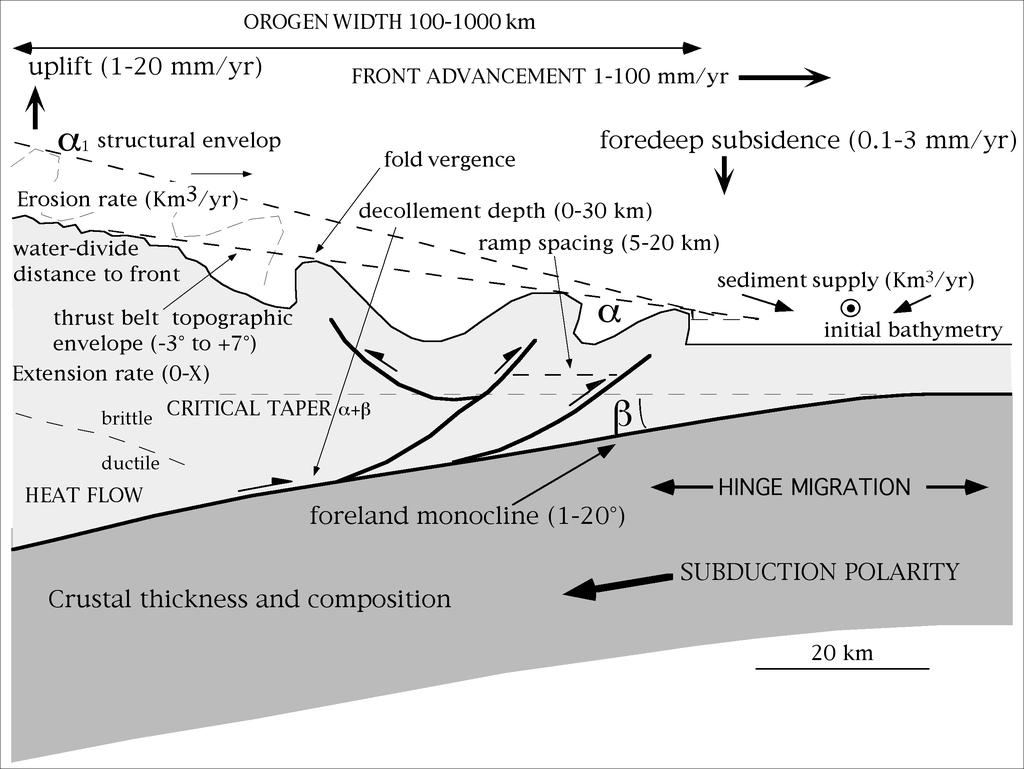
3 describing the triangular shape of rocks at the leading edge of the hangingwall plate along a convergent margin, whether oceanic or continental. The few parameters compiled in the paper are mostly related to the frontal part of the prism, in the brittle regime. However, other larger scale values such as the orogen elevation are controlled by the whole rheology of the belt, both brittle and ductile at depth. The following 12 main subduction zones are analyzed, eight along the circumpacific margins, plus the Banda arc, the Barbados accretionary prism, the Apennines and the Carpathians. The choice was made in order to cover the most important subduction zones worldwide, and it was constrained by the available data along the different prisms. The measured parameters are: the angle of the wedge upper surface (topographic) envelope (α), the depth of the main décollement (both the depth of the base of the wedge and the depth of the stratigraphic décollement layer in the foreland), the cross-sectional area of the belt, and the dip of the foreland monocline (β). This analysis has been carried out from seismic reflection profiles and from regional geologic balanced cross-sections available in the literature (Fig. 1). Geographic polarity of subduction zone and age and composition of lower plate have been related to inclination of the regional monocline (β), wedge topographic envelope (α), depth of the wedge basal décollement, and cross-sectional area of associated belt. The analysis showed an asymmetry, that depends more on geographic polarity rather than on characteristics of subducting lithosphere. Those margins with a E-NE direction of subduction are commonly characterized by higher values of topographic envelope, lower values of dip of the foreland monocline, deeper décollements and higher cross-sectional area of the belt with respect to western margins. Another first order kinematic indicator is the behavior of the subduction hinge that can migrate toward or away from the upper plate (Doglioni et al., 26). 2. The measured parameters In spite of the natural variability, there are elements common to all subduction zones (Chapple, 1978; Davis et al., 1983; Dahlen, 199). The deformation front of orogens, thrust belts or accretionary prisms, has notoriously a wedge-shape geometry in cross-section (Fig. 2), delimited at its top by a topographic surface and at its base by a basal décollement, which separating the prism from the down-going plate. The lower plate generally shows little deformation, except possibly for a few normal faults due to plate bending. While being underthrust, the lower plate 3
4 describes a monocline, i.e., foreland or regional monocline. Fluids flow may play an important role in controlling prism development (Bangs et al., 1999; Silver et al., 2; Roure et al., 25). Climate and erosion have been shown effective on the orogenic evolution (Willett, 1999; Willett et al., 21; Avouac, 23). The aforementioned elements are described by parameters defined by Davis et al. (1983) in their Critical Tapered Wedge Model : the envelope of the wedge s topographic surface and of the regional monocline are described by the angles α and β, respectively (Fig. 2). Their sum, the so-called taper angle (θ = α + β), is a peculiar quantity for each wedge, since it is a function of the physical properties of the material involved in the deformational process and the orientation of the principal stresses (Dahlen et al., 1984; Davis and Engelder, 1985; Dahlen, 199). The importance of the β angle, as one of the descriptive parameters of the geometry of a convergent margin, has also been discussed by Boyer (1995), Mariotti and Doglioni (2), and Koyi and Vendeville (23). Boyer (1995) investigated the consequences of changes in foreland basement pre-deformational dip on deformational styles (in terms of thrust spacing and magnitude of shortening), width, and frontal advance of accretionary wedges. Analyzing the Apennines and the Alps, Mariotti and Doglioni (2) detected two orders variation of the β angle: a first one at the scale of orogens, being steeper beneath the W-directed Apennines subduction (1-15 ) than in the Alps (2-6 ), and a second one at the regional scale, moving along strike. Salients and recesses correspond in general to steeper and shallower regional monocline values occurring along pre-existing Mesozoic basins and swells respectively. Recently Koyi and Vendeville (23) investigated the effect of décollement dip on geometry and mode of deformation of related wedges, by means of sand-box modeling. The geometry of the wedge and of the shallower part of the footwall plate have been determined in our analysis (Fig. 2), measuring parameters defined in the literature (α, β, θ) and new parameters (i.e., basal décollement and proto-décollement depths) on seismic reflection profiles and regional balanced geologic sections available in the literature. A further study parameter is the cross-sectional area of the belt associated to the margin, measured on topographic profiles traced along each study section. The basal décollement (BD) is the deepest thrust of the accretionary prism and clearly deepens and thickens moving toward the interior of the belt. The proto-décollement depth (PD) is instead a fixed value that describes the thickness of the rocks above the basal décollement at the front of the accretionary prism (Fig. 2). 4
5 3. Methodology Seismic reflection profiles and regional geologic balanced cross-sections used in this study are listed in Table 1. Where available, more than one section has been considered for a single margin. Seismic reflection profiles originally in TWT that were depth-converted in this study are: the Apennines section A-5, converted using seismic velocity model in De Voodg et al. (1992), and Catalano et al. (21); the Barbados sections B-1, B-3, and B-4, converted using seismic velocity model in Bangs et al. (199); the Banda sections Ba-1 and Ba-2, converted assuming standard velocities. Measured regional geologic balanced cross-sections are: the Carpathians sections C-1 and C-2, and the Apennines sections A-3, A-4 and A-6. All the remaining sections were seismic reflection profiles originally in depth. The dip of the regional monocline was measured both in the undeformed foreland (β frl ) and below the deformed wedge (β W ) (Fig. 2). The α and β W parameters were studied detecting multiple segmented envelopes on each section, identifying more than one value for both α and β W angles (i.e., α i, β Wi ) and a related horizontal validity interval, i.e., d α i and d βwi (see Fig. 2). Fig. 3 shows geometry of wedges, as drawn by the α i and β Wi angles and relative validity intervals. Afterwards, mean values of α and β W for each section have been calculated as follows (refer to Fig. 2): 1) α 2) β mean = Wmean ( α1 dα 1) + ( α 2 dα 2) ( αn dαn) = d α 1 + d α d αn ( βw1 dβw 1) + ( βw 2 dβw 2) ( βwn dβwn) d 3) ϑ mean = αmean + βwmean β W 1 + d β W d β Wn as reported in Table 1 and Fig. 4. A further element here investigated is the basal décollement, i.e. the deepest fault plane separating the hangingwall plate from the footwall plate (Fig. 2). The significance of the décollement depth on wedge configuration is that a deeper décollement corresponds to a larger volume of material accreted into the wedge, and therefore, under the same friction conditions (Davis and Engelder, 1985; Mulugeta; 1988; Colletta et al., 1991; Huiqui, 1992; Koyi, 1995; Koyi et al., 2), to a higher topographic elevation (Liu et al., 1992). In general, mass transfer 5
6 at subduction zones may mechanically occur in two directions: transfer from the footwall to the hangingwall plate, termed accretion (Karig and Sharman III, 1975; Moore et al., 1984; Moore et al., 1995), and transfer from the hangingwall to the footwall plate, defined as erosion (von Huene, S. Lallemand, 199; von Huene and Scholl, 1991). In the first case the décollement is the deepest thrust involving the footwall plate, whereas in the second case the deformation involves only the hangingwall plate. In this study no distinction has been made on the base of mechanism of mass transfer. The décollement is rather studied as basal décollement depth, BD, i.e., vertical distance between the fault plane itself and the wedge topographic surface, and as protodécollement depth, PD, i.e., thickness of the sediment pile above the stratigraphic décollement layer in the stable foreland (see Fig. 2). The BD has been measured every 5 km starting from the thrust front inward. A BD mean value for each study section has been obtained and a normalized value has also been calculated, as following equations (refer to Fig. 2): 4) BD mean = ( BD1 + BD BDn) n with n equal to the number of measurements on each study section BDmean 5) BD normalized = distance from the thrust front Calculated values are reported in Table 1 and Fig. 4. The operation of normalization has been necessary since the basal décollement strongly depends on the position of the wedge with respect to the subduction hinge: steeper the monocline, deeper the décollement, i.e. the BD is strongly related to β. Nevertheless normalizing the BD mean value ensured a value independent from its study length and therefore comparable. Moreover, increasing β, α tends to decrease, as well as the volume of the involved rocks since décollements are shallower. A topographic profile was drawn along each study section and the area of the belt associated with the margin has been measured, i.e., the cross-sectional area above sea level pertaining to the belt (Table 1 and Fig. 4). An inboard edge of 5 km from trench axis has been used. The length is an arbitrary choice in order to cover most of the double vergent orogens, which are very wide (e.g., Cordillera). The parameters were measured as far as possible on each section (see Fig. 3). Subsequently, an analysis of average values was performed, in function of the polarity of the subduction zone and 6
7 composition of the downgoing plate. Standard errors for calculated mean values have also been computed. On the basis of direction of subduction as a function of the polarity along the undulated mainstream of plate motions (Doglioni, 199; Crespi et al., 26), two classes of subduction zones emerged: the eastern (E- or NNE-directed), and the western (W-directed) classes. The eastern margins include: Cascadia, Middle America, Peru-Chile, and New Hebrides. The western margins include: Aleutians, New Zealand, Nankai, Japan, Barbados, Banda, Apennines and Carpathians. On the basis of composition of the downgoing plate, the groups are: Aleutians, Cascadia, Middle America, Peru-Chile, New Hebrides, New Zealand, Nankai, Japan, Ionian Apennines (section A-5) and Barbados for the oceanic plates; Banda, Apennines and Carpathians for the continental plates. For each group of margins mean values of the parameters have been calculated as follows: 6) α mean * = 7) βfrl* = 8) β 9) ϑ Wmean mean ( αmean) SECTION + ( αmean) SECTION ( αmean) 1 SECTIONn number of sections ( βfrl) SECTION + ( βfrl) SECTION ( βfrl) * = * = 1) PD* = 11) BD 12) Area* = 1 SECTIONn number of sections ( βwmean) SECTION + ( βwmean) SECTION ( βwmean) 1 SECTIONn number of sections ( ϑmean) SECTION + ( ϑmean) SECTION ( ϑmean) 1 SECTIONn number of sections ( PD) SECTION + ( PD) SECTION ( PD) normalized * = 1 SECTIONn number of sections ( BDnormalized) SECTION + ( BDnormalized) SECTION ( BDnormalized) 1 SECTIONn number of sections ( Area) SECTION + ( Area) SECTION ( Area) reported in Table 2 and Fig SECTIONn number of sections 4. The data In Fig. 3 α i, β frl and β Wi and basal décollement depths are plotted for each study section together with their investigated distance. Data are plotted with respect to the frontal thrust which occupies the (,) position both in the envelopes graph and in the BD graph. In the latter the PD value is also reported, where measurable. 7
8 Table 1 reports mean values of the parameters for every study section, as calculated by equations 1) to 5). In Fig. 4 results are plotted versus geographic polarity of subduction zone, distinguishing between continental and oceanic downgoing plates. Table 2 and Fig. 5 show mean values of the parameters for each class of margins, as calculated by equations 6) to 12). Fig. 5a shows that for the investigated margins α mean *, i.e. mean slope of wedge topographic envelopes, is lower in the western class than in the eastern class (1.9±.34 degrees vs. 4.8±.36 degrees), and in the continental class than in the oceanic one (2.3±.68 degrees vs. 3.29±.38 degrees). In general, continental monoclines are steeper than oceanic monoclines (Fig. 5b and 5c). A pronounced difference between the two classes is registered for the dip of regional monocline below the wedge (β Wmean * is 8.87±1.63 degrees for the continental ones vs. 3.29±.42 degrees for the oceanic ones), while statistically it is weak but higher in case of monoclines in the foreland (β frl * is 3.32±1.9 degrees for the continental ones vs. 2.24±.4 degrees for the oceanic ones). In the western class β Wmean * is steeper than in the eastern class: mean value for western margins is 6.1±.96 degrees vs. 2.66±.57 degrees for eastern margins. Fig. 6 shows β frl and β Wmean values plotted versus age of the subducting oceanic plates. Results seem to suggest that there is no linear dependence between age of the crust and dip of the oceanic regional monocline. The mean taper angle, θ mean *, is higher in case of continental subducting plates with respect to oceanic subducting plates (Fig. 5d): 1.5±1.5 degrees vs. 6.58±.61 degrees. Instead, the θ mean * value, the critical taper, is quite similar in case of western and eastern margins, being respectively 7.99±.96 degrees and 7.41±.74 degrees (Fig. 7). This seems to suggest that mechanical laws governing wedges building do not change significantly with geographic polarity: within the two classes, angles of the envelopes invert their values, without considerably modifying their sum. However, the most evident data from Fig. 7 is that, regardless the composition of the downgoing plate, β is steeper and α is shallower for W-directed subduction zones, whereas β is shallower and α is steeper for E- or NE-directed sunduction zones. For the eastern continental subductions (e.g., Alps, Zagros, Himalayas) we refer to literature data (Mariotti and Doglioni, 2; Lenci, 24; Duncan et al., 23; Mugnier and Huyghe, 26). 8
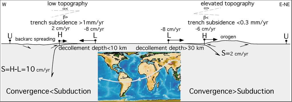
9 5. Other parameters affecting prism evolution Besides the aforementioned analysis, a variety of geometric and kinematic elements determine the bulk structure of an orogen or accretionary prism. They are namely the depth of the basal décollement (e.g., Bigi et al., 23), the convergence rate, the shortening rate, the subduction rate (Doglioni et al., 26), the dip of the foreland monocline (Mariotti and Doglioni, 2), the topographic envelop, the structural envelop, the basal and the internal friction (Dahlen et al., 1984), the foredeep or foreland subsidence rate (Doglioni, 1994), the prism uplift rate, the thrusts spacing (Morellato et al., 23), the heat flow variability, the thickness and composition of the upper and lower plates, the erosion rate (Willett, 1999), the climate, the sediment supply in the foredeep, the extension rate, if any. All these parameters are not discussed in detail here but are nevertheless fundamental in orchestrating the orogen evolution and determining the peculiar character of each single belt. Another crucial parameter, is the behavior of the subduction hinge. The subduction hinge is considered the point where the downgoing footwall plate presents the maximum curvature. It is a transient point that moves during subduction (Royden and Burchfiel, 1989; Waschbusch and Beaumont, 1996; Lallemand et al., 25; Doglioni et al., 26). Relative to the upper plate, the hinge can move toward or away (Fig. 8). The accretionary prism or orogen geometry kinematics are very sensitive to its behaviour, and two opposite settings develop. For example the hinge migrating toward the upper plate occurs with double vergent orogens, higher topography and widely involved deep basement rocks involved, shallow regional monocline and foredeep, no active backarc spreading. The case of subduction hinge migrating away from the upper plate is rather associated to low topography accretionary prism, mostly composed of shallow rocks, deep trench and backarc basin development. Apart few exceptions, this distinction seems to apply particularly for E- or NE-directed subduction zones and W-directed subduction zones respectively. Moreover, the rate of subduction is larger than the convergence rate along W-directed subduction zones whereas it is smaller along E- or NE-directed subduction zones (Fig. 8). Along W-directed slabs, the subduction rate is the convergence rate plus the slab retreat rate, which tends to equal the backarc extension rate. Along E- or NE-directed slabs, the amount of hinge migration toward the upper plate corresponds to the shortening in the orogen. Moreover, the amount of shortening in the 9
10 upper plate decreases the subduction rate, and no typical backarc basin forms. With respect to the subduction zones described in this paper, the subduction hinge migrates away from the upper plate along the Barbados, Carpathians, Apennines, Northern New Zealand, Nankai, Aleutians, all W-directed subduction zones. The Japan subduction, although westerly directed, presently shows a subduction hinge migrating toward the upper plate, indicating inversion of the system, no active backarc extension and shrinking of the basin (Doglioni et al., 26). The others Cascadia, Middle America, Perù, Chile, New Hebrides subduction zones are associated to subduction hinge migrating toward the upper plate (Doglioni et al., 26). Also in Himalaya (e.g., Mugnier and Huyghe, 26) the subduction hinge moves toward the upper plate. 6. Discussion The décollement s parameters (PD* and BD normalized *) are highly influenced by nature of downgoing plates (Table 2, Fig. 5e and 5f). It is known that the décollement is shallower in cases of subduction of oceanic lithosphere (Moore et al., 1991), while in continental subduction the depth increases considerably, probably due to the greater thickness of sedimentary cover on continental crust. Lenci et al. (24) have shown how in the Apennines the accretionary prism involving a shallower section (<3 km) of the Ionian oceanic crust sedimentary cover determined a smaller volume than the setting to the north, in the central-northern Apennines, where the accretionary prism has a deeper décollement (>1 km) and a consequent larger volume in the prism, in spite of a smaller amount of subduction due to the continental nature of that segment of the slab. The shallower décollement allows the generation of a salient and the accretionary prism is therefore more advanced with respect to the deeper décollement, where the accretionary prism is thicker, the lithostatic load on the décollement is higher. This generates a recess of the prism (Fig. 9). This study confirms the above statement and gives a bulk estimate of the differences between the two compositional contexts at least for the 12 considered subduction zones. On the oceanic plates (see Table 1), the sedimentary cover entering subduction zones, i.e. PD*, is 1.26±.19 km thick on average, whereas it reaches 5.87±1.43 km on average on the continental downgoing plates. The dimensionless parameter representing the mean depth of the basal décollement (BD * normalized, measured as in equation 11) is.16±.24 in the continental plates and 1
11 .15±.16 in the oceanic ones. It means that at the same distance from the thrust front, the basal décollement might be nearly 1.5 times deeper in the continental wedges than in the oceanic ones with a proto-décollement depth 4.5 times higher in the continental downgoing plates than in the oceanic ones. Belts on top of W -directed subduction zones (Fig. 5g) show the lowest area values (Fig. 1): Area* is 48±9 km 2 for the western margins and 317±72 km 2 for the eastern margins. Moreover, with the exception of sections NH-1 and NH-2 and of section CR-1, all of the western sections have a lower cross-sectional area of the belt with respect to E-NE - directed subduction zones sections (see Fig. 4g). As an accepted general rule, the deeper the décollement, the larger the volume of the accretionary wedge. We remind that the depth of the décollement is considered as the thickness of an undeformed crust involved by deformation. During nappe stacking deeper décollement planes generate internally, while the accretion occurs at shallower more external stratigraphic layer. Shallow décollement in the accretionary prism related to the western margins generate smaller volumes of accreted rocks and the topography is then low. The measured depth of the décollement on these prisms (e.g., Apennines, Barbados, Nankai) tends to be shallower than 1 km. The highest topographic elevations, in fact, occur in belts associated with eastern margins (Fig. 1), such as the Cascadia, the Middle America and the Peru-Chile Trench as well as the Alps, the Zagros and the Himalaya (Harabaglia and Doglioni, 1998). In these belts the décollement and thrust planes affect the whole crust and enter in the upper mantle. Therefore the basal décollement is >3 km and the orogen is highly elevated. This asymmetry points to a worldwide deeper involvement of the lithosphere along E-NE-directed subduction zones. This analysis seems to suggest that we can interpret the variable geometry of each margin within the two classes, western and eastern, but considering the interplay between parameters together with local characteristics. That is we have to consider the interplay between dip of the downgoing plate, and thickness of the sedimentary cover (i.e., the availability of material that can be accreted into the wedge) and their effect onto the other parameters. For instance, in the Eastern Aleutians (section Al-3), where the Pacific plate is subducting north-westward, the wedge shows a higher value of α mean with respect to the average value of the western margins: α mean is 4.7 degrees vs. α mean * of 1.9±.34 degrees for western margins or α mean * of 2.38±.43 for oceanic western margins. This is probably due to the proximity of the wedge to 11
12 the Alaska continental platform, and the consequent thick sedimentary cover above the subducting plate as shown by the relative PD value: a greater volume of sediments entering the wedge necessarily leads to a thicker wedge, other conditions being equal (such as friction on the décollement plane and material involved). Another apparent outlier is represented by the Central Apennines, where the continental Adriatic lithosphere is subducting westward, as clearly evidenced by tomographic images (Ciaccio et al., 1998; De Gori et al., 21; Piromallo and Morelli, 23) and by a few hundreds kilometers shortening in the passive continental margin sedimentary sequences involved in the accretionary wedge (Bally et al., 1986). In this area (sections A-3 and A-4), the regional monocline has a low dip value. This is probably due to a lower subductibility of the Adriatic plate in this sector, as suggested by Mariotti and Doglioni (2). The complex crustal history of the Adriatic plate, in fact, led to a high lateral variability in thickness, composition and rheology, and, consequently, in mechanical behavior when involved in mountain building, as also shown by the variation along strike of the measured parameters (see Fig. 3 and Table 1). Moreover, the New Zealand and Barbados sections are characterized by a lower β Wmean with respect to the mean value of western monoclines. On the other hand, the α mean and PD values are included among the average (see Table 1). A possible explanation can be found in the relative position of the wedge with respect to the subduction hinge (Fig. 9): due to a high efficiency décollement the wedge may advance further over the incoming plate, i.e., above a less dipping portion of the monocline. This explains also the high value of the dip of continental monoclines, and the low values of the slope of the related wedge topographic envelope. In continental subduction, in fact, the increased depth to the basal décollement (see Fig. 3, Tables 1 and 2) can result in the accretionary wedge being thicker, but not extending as far out over the incoming continental plate. The measured regional monocline dip in a continental downgoing plate can be higher (Fig. 7) than that of an oceanic plate, due to the different position of the wedge above the plate (Fig. 9), and as a consequence the frontal part of the wedge will be characterized by very low values of the wedge topographic envelope, since the wedge does not develop frontal topography (compare average values in Table 2). The Apennines clearly show this mechanism, with high β W values and low α angles. The α values become negative (i.e., landward dipping) if we consider the envelope of the growing folds crests at the front of the wedge such as in the Northern Apennines (Doglioni and Prosser, 1997). 12
13 Other outliers are: section N-2, which probably shows anomalous values due to the shortness of the section (compare with sections N-1 and N-3 in Fig. 3); the Chile section (Ch), with high values of β, both in the foreland (β frl ) and below the wedge (β Wmean ), due to the proximity of the section to the Chile Ridge, so that part of the dip is related to the thermal state of the young oceanic crust; the New Hebrides sections (NH-1, NH-2), which anomalous values have probably to be related to the complexity and early age of the subduction zone (Pysklywec et al., 23 and references therein); the Japan section (J), which shows a high α mean value, probably to be connected to a high friction décollement plane (Gutscher et al., 1998), or the inversion of the system. In fact the subduction hinge is now moving toward the upper plate (Doglioni et al., 26). The (α+β) value is greater for the continental subducting plate than for the oceanic subducting plate as a general rule, regardless the polarity of the subduction. This can be explained by the lower density of continental rocks and the consequent deeper décollement accreting rocks, preventing their subduction and increasing the volume of the orogen. Moreover it seems confirmed that wedge envelope is lower when it is subaerial than when it is submarine, due to the water load and to the erosion. However this distinction is beyond the scope of this paper. 7. Conclusions The thrust belts and orogens in general are the combination of a number of distinct parameters (Fig. 11). However, as a first order signature, two main types of subduction zones and related orogens can be distinguished (Fig. 8), i.e., 1) those where the subduction hinge migrates away from the upper plate, and 2) those in which the subduction hinge migrates toward the upper plate (Doglioni et al., 26). The steeper foreland monocline and faster subsidence rates in the trench or foredeep (>1 mm/yr, Doglioni, 1994), the lower topographic envelope and the smaller crosssectional area occur where the subduction hinge migrates away from the upper plate. This setting is usually associated to W-directed subduction zones, and since the hinge rolls back from the upper plate, the dip of the slab and the related hinge are more pronounced. An exception is the W-directed Japan subduction where the hinge is migrating toward the upper plate (Doglioni et al., 26), but the system is inverting and the backarc basin shrinking (Mazzotti et al., 21). In 13
14 the opposite E- or NE-directed subduction zones (along the undulated flow of Fig. 8), the hinge migrates systematically toward the upper plate, the slab is generally less inclined and shallower. As a consequence, the foreland regional monocline mimics the slab behavior, since it is the uppermost part of it, and it is shallower, less inclined, and the subsidence rate is low (<.3 mm/yr). The topographic envelop is steeper than in the opposite setting, and the cross-sectional area is very large. If we compare the foreland monocline dip data in Table 1, and consider this value as representative of the dip of the shallow part of the subducting slab, we observe that the older-heavier-steeper model holds locally but is not a general rule (Fig. 6). Cruciani et al. (25) have shown how the slab dip in the first 25 km is not simply correlated to the age of the slab. Other controlling factor may operate in determining the inclination of slabs, such as the thickness of the overriding plate and the eastward mantle flow implicit with the recognition of the westward drift of the lithosphere (Doglioni et al, 1999; Crespi et al., 26). This analysis confirmed that subducting plate nature is only partly a controlling factor on the morphology of frontal and shallower part of subduction zones. In particular, along W-directed subduction zones, continental convergent margins are characterized by a lower slope of the wedge topographic envelope, a steeper regional monocline, a deeper décollement (both in terms of sediments entering the wedge and basal wedge detachment) with respect to oceanic convergent margins. Moreover this analysis showed an asymmetry of studied convergent margins, which can be described by the lower α - higher β - shallower décollement - lower area versus higher α - lower β - deeper décollement - higher area proposition. This asymmetry seems more sensitive to the geographic polarity, i.e., W-directed versus E-NE-directed subduction zones. Alternatively it can be described by the opposite behavior of the subduction hinge, migrating away or toward the upper plate, rather than to the age of the oceanic lithosphere or the subducting plate nature. Although located closer to the subduction hinge (Fig. 9a), the Apennines continental sections, for example, show a geometry of both wedge and foreland monocline which is comparable to that of the western oceanic sections. Further similar examples are: i) the Carpathians (Roure et al., 1993), characterized by a blocked vertical continental slab following the interpretation of Oncescu (1984), ii) the Banda arc, where the Australian continental lithosphere is subducting westward (Tandon et al., 2), and iii) the Sandwich arc, where, although the westward 14
15 subducting oceanic lithosphere is of variable age, the arc geometry is laterally uniform and comparable to that of Barbados and western pacific margins. Subsidence rate in the foredeep is much faster (>1mm/yr) along foredeeps of W-directed subduction zones and the regional monocline is steeper (Doglioni, 1992; 1994). The prism related to these subductions has shallow depth of the basal décollement and is composed mostly by shallow rocks and sedimentary cover. The structural elevation is instead very elevated along orogens related to E-NE-directed subduction zones where the basal décollement is deeper than the crust and deep rocks are extensively involved in the orogen (Doglioni et al., 1999). The single vergent accretionary prism related to W-directed subduction zones is formed at the expenses of the shallow layers of the lower plate (e.g., Apennines, Carpathians, Barbados). The orogens generated by E- or NE-dipping subductions are double vergent since the early stages, and upper plate rocks mostly compose them (e.g. Andes) until the continental collision takes place, extensively involving the rocks of the lower plate (e.g., Alps, Zagros, Himalayas). The convergence/shortening ratio in this type of orogens is higher than 1 and is inversely proportional to the viscosity of the upper plate. Higher the viscosity, smaller the shortening and faster the subduction rate. The convergence/shortening ratio along W-directed subduction zones is instead generally lower than 1 (Doglioni et al., 26). The foreland regional monocline is in average steeper along W-directed subduction zones than along the opposite settings (Fig. 9). The topographic envelope is instead less inclined and the critical tape slightly smaller than along orogens related to E- or NE-directed subduction zones (Fig. 9). This asymmetry is particularly highlighted by topography, being W-directed subduction zones characterized by much lower elevation than the opposite settings (Fig. 1). The present analysis proposes the polarity of the subduction as a plausible key-reading of convergent margins. These asymmetries can be related to the rotational forces controlling plate tectonics and determining a net rotation of the lithosphere roughly westerly directed (Scoppola et al., 26) along the undulate flow of plate motions (Doglioni, 199). Therefore the first order control on orogens and accretionary prisms can be global, determining two end-member classes geographically controlled (Fig. 8), whereas local/regional stratigraphic-rheological characteristics (e.g., Bigi et al., 22) may cause diversions from the expected theoretical behavior without completely obscuring the geographic tuning (Fig. 11). A possible explanation of this tuning could be provided by the westward drift of the lithosphere. The net rotation of 15
16 the lithosphere relative to the asthenospheric mantle has been suggested by a number of authors, i.e., Rittman (1942), Le Pichon (1968), Bostrom (1971), Nelson and Temple (1972), Dickinson (1978), Uyeda and Kanamori (1979), Doglioni (199), Gripp and Gordon (22), Crespi et al. (26). As a consequence of the delay of the lithosphere with respect to the underlying mantle, a main flow of plate motions should develop: signal and consequence of this main flow should be represented by the asymmetry of subduction zones (Doglioni et al., 1999). Recently, Scoppola et al. (26) have proposed the occurrence of very low viscosity intra-asthenospheric layers allowing the tidal drag to be efficient in determining the westward lithospheric rotation. Acknowledgements: Sabina Bigi, Eugenio Carminati, Marco Cuffaro and Davide Scrocca are thanked for fruitful discussions and valuable help. Francois Roure and William Sassi stimulated our participation to the meeting. Reviews by Jean-Louis Mugnier, Reini Zoetemeijer and an anonymous referee improved the paper. Research supported by Cofin and La Sapienza University (grant Ateneo C. Doglioni). Topographic analysis and some of the figures were carried out by means of GMT- Generic Mapping Tools of Wessel and Smith (1995). References Avouac, J.-P., 23. Mountain building, erosion, and the seismic cycle in the Nepal Himalaya. Advances in Geophysics, v. 46, p. 1-8, DOI: 1.116/S (3) Bally A.W., Burbi L., Cooper C., Ghelardoni R. (1986): Balanced sections and seismic reflection profiles across the central Apennines. Mem. Soc. Geol. It., 35, Bangs, N.L., Shipley, T.H., Moore, J.C., and Moore, G., 1999, Fluid accumulations and channeling along the Northern Barbados Ridge décollement thrust: Journal of Geophysical Research, v. 14, p. 2,399-2,414. Bangs N.L.B., Westbrook G.K., Ladd J.W., Buhl P. (199): Seismic Velocities From the Barbados Ridge Complex: Indicators of High Pore Fluid Pressures in an Accretionary Complex. J. Geophys. Res., 95, Behrmann J.H., Lewis S.D., Cande S.C. (1994): Tectonics and geology of spreading ridge subduction at the Chile Triple Junction: a synthesis of results from Leg 141 of the Ocean Drilling Program. Geol. Rundsch, 83, Bello M., Franchino A., Merlini S. (2): Structural model of Eastern Sicily. Mem. Soc. Geol. It., 55, Bigi S., Lenci F., Doglioni C., Moore J.C., Carminati E. & Scrocca D. (23): Décollement depth vs accretionary prism dimension in the Apennines and the Barbados. Tectonics, 22, 2, 11, doi:1.129/22tc
17 Bostrom, R.C., 1971, Westward displacement of the lithosphere: Nature, v. 234, p Boyer S.E. (1995): Sedimentary basin taper as a factor controlling the geometry and advance of thrust belt. Amer. J. Sci., 295, Bruns T.R., von Huene R. (1986): Aleutian Trench, Shumagin Segment, Seismic Section 14. In: R. von Huene (Ed.), Seismic images of modern convergent margin tectonic structure. AAPG Studies in Geol., vol. 26, Tulsa, OK, United States, pp Catalano R., Doglioni C., Merlini S. (21): On the Mesozoic Ionian basin. Geophys. J. Int., 144, Cernobori L., Hirn A., McBride J.H., Nicolich R., Petronio L., Romanelli M., STREAMERS/PROFILES Working Groups (1996): Crustal image of the Ionian basin and its Calabrian margins. Tectonophysics, 264, Chapple W.M. (1978): Mechanics of thin-skinned fold and thrust belts. Geol. Soc. Am. Bull., 89, Ciaccio M.G., Cimini G.B., Amato A. (1998): Tomographic images of the upper mantle highvelocity anomaly beneath the Northern Apennines. Mem. Soc. Geol. It., 52, Colletta B., Letouzey J., Pinedo R., Ballard J.F., Balé P. (1991): Computerized X-ray tomography analysis of sandbox models: examples of thin-skinned thrust systems. Geology, 19, Collins B.P., Watkins J.S. (1986): The Middle American Trench. In: R. von Huene (Ed.), Seismic images of modern convergent margin tectonic structure. AAPG Studies in Geol., vol. 26, Tulsa, OK, United States, pp Crespi M., Cuffaro M., Doglioni C., Giannone F., Riguzzi F. (26): Space geodesy validation of the global lithospheric flow. Geophys. J. Int., in press. Crostella A.A., Powell D.E. (1976): Geology and hydrocarbon prospects of the Timor area. Indon. Petrol. Ass. Proc., 4, Cruciani C., Carminati E. and Doglioni C. (25): Slab dip vs. lithosphere age: no direct function. Earth Planet. Sci. Lett., 238, Dahlen F.A. (199): Critical taper model of fold and thrust belts and accretionary wedge. Earth Planet. Sci. Lett., 19, Dahlen F.A., Suppe J., Davis D. (1984): Mechanics of Fold-and-Thrust belts and Accretionary Wedges: Cohesive Coulomb Theory. J. Geophys. Res., 89, Davey, F.J., Childs J.R. (1986): Convergent Margin off East Coast of North Island, New Zealand, Parts I and II. In: R. von Huene (Ed.), Seismic images of modern convergent margin tectonic structure. AAPG Studies in Geol., vol. 26, Tulsa, OK, United States, p.49. Davis D.M., Engelder T. (1985): The role of salt in fold-and-thrust belts. Tectonophysics, 119, Davis D.M., Suppe J., Dahlen F.A. (1983): Mechanics of Fold-and-Thrust Belts and Accretionary Wedges. J. Geophys. Res., 88, De Gori P., Cimini G.B., Chiarabba C., De Natale G., Troise C., Deschamps A. (21): 17
18 Teleseismic tomography of the Campanian volcanic area and surrounding Apenninic belt. J. Volcanol. Geothermal Res., 19, De Voogd B., Truffert C., Chamot-Rooke N., Huchon P., Lallemand S., Le Pichon X. (1992): Two-ship deep seismic soundings in the basins of the Eastern Mediterranean Sea (Parsiphaea cruise). Geophys. J. Int., 19, Dickinson, W.R., 1978, Plate tectonic evolution of North Pacific rim: Journal Physics Earth, v. 26, Suppl Doglioni C. (199): The global tectonic pattern. J. Geodyn., 12, Doglioni C. (1992):Main differences between thrust belts. Terra Nova, 4, Doglioni C. (1993): Geological evidence for a global tectonic polarity. J. Geol. Soc. London, 15, Doglioni C. (1994): Foredeeps versus subduction zones. Geology, 22, 3, Doglioni C., Carminati E., Bonatti E. (23): Rift asymmetry and continental uplift. Tectonics, 22, doi:1.129/22tc1459. Doglioni C., Carminati E., Cuffaro M. (26): Simple kinematics of subduction zones. Int. Geol. Rev., 48, 6, Doglioni C., Harabaglia P., Merlini S., Mongelli F., Peccerillo A., Piromallo C. (1999): Orogens and slabs vs their direction of subduction. Earth Science Reviews, 45, Doglioni C., Prosser G. (1997): Fold uplift versus regional subsidence and sedimentation rate. Marine and Petrol. Geol., 14, Duncan C., Masek J., Fielding E. (23):How steep are the Himalaya? Characteristics and implications of along-strike topographic variations. Geology, 31, 1, Fisher M.A., Greene H.G. (1986): The New Hebrides Trench, Lines 1 and 12. In: R. von Huene (Ed.), Seismic images of modern convergent margin tectonic structure. AAPG Studies in Geol., vol. 26, Tulsa, OK, United States, pp Forsyth D., Uyeda S. (1975): On the relative importance of driving forces of plate motion. Geophys. J. R. Astron. Soc., 43, Garzanti E., Doglioni C., Vezzoli G., Andò S. (26): Orogenic Belts and Orogenic Sediment Provenances. J. Geol., in press. Gripp A.E., Gordon R.G. (22): Young tracks of hotspots and current plate velocities. Geophys. J. Int., 15, Gutscher M.A., Kukowski N., Malavieille J., Lallemand S. (1998): Material transfer in accretionary wedges from analysis of a systematic series of analog experiments. J. Struct. Geol., 2, Hager B. H., O'Connell R. J. (1978): Subduction zone dips and flow driven by the plates, Tectonophysics, 5, Harabaglia P., Doglioni C. (1998): Topography and gravity across subduction zones. Geophys. Res. Lett., 25,
19 Huiqui L., McClay K.R., Powell D. (1992): Physical models of thrust wedges. In: K.R. McClay (Ed.), Thrust Tectonics, London, Chapman & Hall, pp Isacks B.L., Barazangi M. (1977): Geometry of Benioff zones: lateral segmentation and downwards bending of the subducted lithosphere. In: M. Talwani, W.C. Pitman (Eds.), Island Arcs, Deep Sea Trenches and Back Arc Basins, American Geophysical Union, Washington, DC, pp Jarrard R.D. (1986): Relations among subduction parameters. Rev. Geophys., 24, Karig D.E., Sharman III G.F. (1975): Subduction and accretion in trenches. Geol. Soc. Am. Bull., 86, Kawamura T., Aoki Y. (1986): The Nankai Trough Margin, record In: R. von Huene (Ed.), Seismic images of modern convergent margin tectonic structure. AAPG Studies in Geol., vol. 26, Tulsa, OK, United States, pp Kolarsky R.A., Mann P., Montero W. (1995): Island Arc Response to Shallow Subduction of the Cocos Ridge, Costa Rica. In: P. Mann (Ed.), Geologic and Tectonic Development of the Caribbean Plate Boundary in Southern Central America. Geol. Soc. Am., Spec. Paper, 295, pp Koyi H. A. (1995): Mode of internal deformation in sand wedge. J. Struct. Geol., 17, Koyi H. A., Hessami K., Teixell A. (2): Epicenter distribution and magnitude of earthquakes in fold-thrust belts: insights from sandbox models. Geophys. Res. Lett., 27, Koyi H.A., Vendeville B.C. (23): The effect of décollement dip on geometry and kinematics of model accretionary wedges. J. Struct. Geol., 25, Kulm L.D., Miller J., von Huene R. (1986): The Peru continental margin, record section 2. In: R. von Huene (Ed.), Seismic images of modern convergent margin tectonic structure. AAPG Studies in Geol., vol. 26, Tulsa, OK, United States, pp Ladd J.W., Westbrook G.K., Buhl P., Bangs N. (199): Wide-aperture seismic profiles across the Barbados Ridge complex. In: J.C. Moore, A. Mascle, et al. (Eds.), Proc. ODP, Sci. Results, 11, College Station, TX (Ocean Drilling Program), pp Lallemand, S., Heuret, A., Boutelier, D., 25, On the relationships between slab dip, back-arc stress, upper plate absolute motion and crustal nature in subduction zones: Geochem. Geophys. Geosyst., 6, Q96, doi:1.129/25gc917. Lenci F. (23): Monoclinale regionale e orogeni nelle zone di subduzione. PhD Thesis, Università La Sapienza, p Lenci F., Carminati E., Doglioni C., Scrocca D. (24): Basal Décollement and Subduction Depth vs. Topography in the Apennines-Calabrian arc. Bollettino Soc. Geol. It., 123, Le Pichon, X., 1968, Sea-fl oor spreading and continental drift: Journal of Geophysical Research, v. 73, no. 12, p Liu H., McClay K.R., Powell D. (1992): Physical models of thrust wedge. In: K.R. McClay (Ed.), Thrust tectonics, Chapman and Hall, London, pp
20 Mariotti G., Doglioni C. (2): The dip of the foreland monocline in the Alps and Apennines. Earth Planet. Sc. Lett., 181, Mazzotti, S., Henry, P., Le Pichon, X., 21, Transient and permanent deformation of central Japan estimated by GPS 2. Strain partitioning and arc-arc collision: Earth Planet. Sci. Lett., v. 184, p Miller J., Hussong D., von Huene R. (1986): The Peru continental margin, record section 3. In: R. von Huene (Ed.), Seismic images of modern convergent margin tectonic structure. AAPG Studies in Geol., vol. 26, Tulsa, OK, United States, pp Moore J.C., Bjiu-Duval B., Natland J.H., The Leg 78 Shipboard Scientific Party (1984): Offscraping and underthrusting of sediment at the deformation front of the Barbados Ridge; an introduction to the drilling results of Leg78A and explanatory notes. In: S. Orlofsky (Ed.), Deep Sea Drilling Project, Init. Rep., 78A, Washington, D.C., U.S. Govt. Printing Office, pp Moore J.C., Taira A., Moore G. (1991): Ocean drilling and accretionary processes. GSA Today, 1, 265, Moore G.F., Zhao Z., Shipley T.H., Bangs N., Moore J.C. (1995): Structural setting of the Leg 156 area, Northern Barbados Ridge accretionary prism. In: T.H. Shipley, Y. Ogawa, P. Blum, et al. (Eds.), Proc. ODP, Init. Repts., 156, College Station, TX (Ocean Drilling Program), pp Morellato C., Redini F., Doglioni C. (23): On the number and spacing of faults. Terra Nova, 15, , doi: 1.146/j x Mugnier J.-L., Huyghe P. (26): Ganges basin geometry records a pre-15 Ma isostatic rebound of Himalaya. 34, 6, p , doi: 1.113/G Mulugeta G. (1988): Modelling the geometry of Coulomb thrust wedge. J. Struct. Geol., 1, Nelson T.H., Temple P.G. (1972): Mainstream mantle convection, a geologic analysis of plate motion. Am. Ass. of Petrol. Geol. Bull., 56(2), O'Connell R., Gable C.G, Hager B. (1991): Toroidal-poloidal partitioning of lithospheric plate motions, in: R. Sabadini et al. (Eds.), Glacial Isostacy, Sea-Level and Mantle Reology, 334, Kluwer Academic Publisher, Dordretch, Oncescu M.C. (1984): Deep structure of the Vrancea region, Romania, inferred from simultaneous inversion for hypocentres and 3-D velocity structure. Ann. Geophys., 2, Pieri M. (1983): Three seismic profiles through the Po Plain. In: A.W. Bally (Ed.), Seismic expression of structural styles, AAPG Studies in Geol., vol. 15(3), Tulsa, OK, United States, pp / /26. Piromallo C., Morelli A. (23): P-wave tomography of the top 1 km under the Alpine- Mediterranean mantle. J. Geophys. Res., 18, doi:1.129/21jb169. Pysklywec R.N., Mitrovica J.X., Ishii M. (23): Mantle avalanche as a driving force for tectonic reorganization in the southwest Pacific. Earth Planet. Sc. Lett., 29,
21 Ranero C., von Huene R., Flueh E., Duarte M., Baca D., McIntosh K.D. (2): A cross section of the convergent Pacific margin of Nicaragua. Tectonics, 19, Ricard Y., Doglioni C., Sabadini R. (1991): Differential rotation between lithosphere and mantle: a consequence of lateral viscosity variation. J. Geophys. Res., 96, Rittmann, A., 1942, Zur thermodynamik der orogenese: Geologische Rundschau, v. 33, p Roure F., Roca E., Sassi W. (1993): The Neogene evolution of the outer Carpathian flysch units (Poland, Ukraine and Romania): kinematics of a foreland/fold-and-thrust belt system. Sediment. Geol., 86, Roure, F., Swennen, R., Schneider, F., Faure, J.L., Ferket, H., Guilhaumou, N., Osadetz, K., Robion, P. and Vandeginste, V. (25) Incidence and Importance of Tectonics and Natural Fluid Migration on Reservoir Evolution in Foreland Fold-and-Thrust Belts, Oil & Gas Science and Technology Rev. IFP, Vol. 6 (25), No. 1, pp Royden L.H., Burchfiel B.C. (1989): Are systematic variation in thrust belt style related to plate boundary processes? (the western Alps versus the Carpathians). Tectonics, 8, Scoppola B., Boccaletti D., Bevis M., Carminati E., Doglioni C. (26): The westward drift of the lithosphere: a rotational drag? Bull. Geol. Soc. Am., 118, 1/2; p ; doi: 1.113/B Schluter H.U., Fritsch J. (1985): Geology and tectonics of the Banda Arc between Tanimbar Island and Aru Island (Indonesia) results of R/V Sonne Cruise SO-16, Geologisches Jahrbuch Reihe, E 3, 44. Scholl D.W., McCarthy J., Ryan H. (1986): Forearc Margin, Central Aleutian Ridge. In : R. von Huene (Ed.), Seismic images of modern convergent margin tectonic structure. AAPG Studies in Geol., vol. 26, Tulsa, OK, United States, pp Shipboard Scientific Party (2): Leg 19 Preliminary Report: Deformation and fluid flow processes in the Nankai Trough accretionary prism, ODP Prelim. Rpt., 19 [Online], available from: Shipley T.H., Buffler R.T. (1986): Costa Rica continental Margin: Line CR-7,. In: R. von Huene (Ed.), Seismic images of modern convergent margin tectonic structure. AAPG Studies in Geol., vol. 26, Tulsa, OK, United States, pp Snavely P.D. Jr., von Huene R., Miller J. (1986): The Central Oregon Continental Margin, Lines WO76-4 and WO76-5. In: R. von Huene (Ed.), Seismic images of modern convergent margin tectonic structure. AAPG Studies in Geol., vol. 26, Tulsa, OK, United States, pp Tandon K., Lorenzo J. M., O'Brien G. W. (2): Effective Elastic Thickness of the Northern Australian Continental Lithosphere Subducting Beneath the Banda Orogen (Indonesia): Inelastic Failure at the Start of Continental Subduction. Tectonophysics, 329, Uyeda S., Kanamori H. (1979): Back-Arc Opening and the Mode of Subduction. J. Geophys. Res., 84,
22 von Huene R., Fisher M., Miller J. (1986): The Eastern Aleutian Continental Margin. In: R. von Huene (Ed.), Seismic images of modern convergent margin tectonic structure. AAPG Studies in Geol., vol. 26, Tulsa, OK, United States, 1986, pp von Huene R., Lallemand S. (199): Tectonic erosion along the Japan and Peru convergent margins. Geol. Soc. Amer. Bull., 12, von Huene R., Nasu N., Culotta R., Aoki Y. (1986): The Japan Trench: line ORI In: R. von Huene (Ed.), Seismic images of modern convergent margin tectonic structure. AAPG Studies in Geol., vol. 26, Tulsa, OK, United States, pp von Huene R., Scholl D.W. (1991): Observations at convergent margins concerning sediment subduction erosion, and the growth of continental crust. Rev. Geophys., 29, Waschbusch P., Beaumont C. (1996): Effect of slab retreat on crustal deformation in simple regions of plate convergence. J. Geophys. Res., 11, Wessel P., Smith W. H. F. (1995): New Version of the Generic Mapping Tools Released. EOS Trans, AGU, 76, 329. Westbrook G.K., Ladd J.W., Buhl P., Bangs N., Tiley G. (1988): Cross section of an accretionary wedge: Barbados Ridge Complex. Geology, 16, Willett, S.D., 1999, Orogeny and orography: The effects of erosion on the structure of mountain belts: Journal of Geophysical Research, v. 14, p Willett, S.D., Slingerland, R., and Hovius, N., 21, Uplift, shortening and steady state topography in active mountain belts: American Journal of Science, v. 31, p
23 FIGURE CAPTIONS Fig. 1. Studied margins, location and nomenclature of the sections. Fig. 2. Main elements characterizing the frontal and shallower part of a subduction zone (top right) and interpreted seismic reflection line with measured parameters (modified from Scholl et al., 1986). α) angles with respect to an horizontal reference line of the wedge topographic envelopes, α 1 and α 2, and relative horizontal validity interval, d α1 and d α2. β) angles with respect to an horizontal reference line of the regional monocline envelopes in the stable foreland, β frl, and below the wedge, β W1 and β W2, and relative horizontal validity interval, d βfrl, d βw1 and d βw2. Basal décollement depth, BD) wedge thickness measured each 5 km inward the thrust front. Proto-décollement depth, PD) thickness of sediments above the stratigraphic décollement layer in the foreland. Fig. 3. Raw data for each study section: wedges topographic envelopes and regional monoclines envelopes with measured angles; related basal décollement profiles with proto-décollement depth, where measured. A reference plot for the envelopes is also present (top right). Due to different length of sections, plots have different scale and different vertical exaggeration. BD, basal décollement, PD, proto-décollement. Fig. 4. Results of the analysis for each study section. Sections are distributed along the x axis following their spatial orientation (i.e., azimuth and polarity of related subduction zone), from W to E. Subduction of continental and oceanic crust is also distinguished. See Figure 1 and Table 1 for sections nomenclature, location and orientation. a) Slope of the wedge topographic envelope (α mean, as in equation 1). b) Dip of the regional monocline in the foreland (β frl ). c) Dip of the regional monocline below the wedge (β Wmean, as in equation 2). d) Mean taper angle (θ mean, as in equation 3). e) Proto-décollement depth (PD). f) Basal décollement depth normalized to length of section (BD normalized as in equation 5). g) Cross-sectional area of the belt. 23
24 Fig. 5. Results based on geographic polarity of margins and composition of lower plates. a) Mean slope of the wedge topographic envelope (α mean *, as in equation 6); b) mean dip of the regional monocline in the foreland (β * frl, as in equation 7); c) mean dip of the regional monocline below the wedge (β Wmean *, as in equation 8); d) mean taper angle (θ mean *, as in equation 9); e) mean proto-décollement depth (PD*, as in equation 1); f) mean basal décollement depth normalized to length of sections (BD normalized * as in equation 11); g) mean cross-sectional area of the belt (Area*, as in equation 12). Fig. 6. Dip of the regional monocline for each oceanic section as a function of the age of ocean floor, a) in the foreland and b) below the wedge. Note the absence of linear dependence between age and dip of the subducting oceanic monocline. Fig. 7. Average values of the topographic envelope (α), dip of the foreland monocline (β), and critical taper (=α+β) for the two classes of subduction zones, i.e., W-directed and E- or NEdirected. Note that the "western" classes show lower values α and steeper values of β. Fig. 8. Simple kinematics of subduction zones, assuming fixed the upper plate U. More frequently along west-directed subduction zones, the subduction hinge H diverges relative to U, whereas it converges along the opposite subduction zones. L, lower plate. The velocities are just an example and are positive when they diverge, being negative in convergent settings relative to U. Note that the subduction S is larger than the convergence along W-directed slabs, whereas S is smaller in the opposite case. The two end-members of hinge behavior are respectively accompanied in average by low and high topography, steep and shallow foreland monocline, fast and slower subsidence rates in the trench or foreland basin, single vs. double vergent orogens, etc., highlighting a worldwide subduction asymmetry along the flow lines of plate motions indicated in the insert. Fig. 9. Schematic diagrams showing difference in dip of the foreland monocline (β) and slope of the wedge topographic envelope (α), starting from the same hypothetical plate curvature, in case of a W-directed subduction zone where a) the slab is continental lithosphere, and b) oceanic lithosphere. Due to a deeper décollement, wedges developing on top of subducting continental 24
25 lithosphere (a) are less advanced with respect to the oceanic ones (b), therefore for the same plate curvature they sit on portion of the foreland monocline, which is more inclined. As a consequence, the frontal portion of a continental wedge may show very little topography, with α values, which are often equal to zero and the envelope to the anticlines may be even negative (as for the Apennines). Note that the continental décollement may coincide with the base of the sedimentary cover, or even involve part of the crystalline crust. Fig. 1. Average values of the area above sea-level of few subduction zones, showing how orogens above E- or NE-directed subduction zones are about 6-8 times larger than the W- directed subduction zones-related accretionary prisms. Fig. 11. The orogens are structured by the combination of a number of parameters, the most important listed in the figure. 25
26 Table 1. Results. Margin Section Source Subducting plate Reference Position α mean β frl β Wmean θ mean BD PD Area (Lat., Long.) ( ) ( ) ( ) ( ) normalize (km 2 composition age direction of ) (Myr) z subduction aa azimuth Aleutians Al-1 a) 5.5, oceanic 54 NW Al-2 b) 54, oceanic 46 NW Al-3 c) 56, oceanic 46 NW -36. Cascadia CO-1 d) 44.7, oceanic 8 E-NE CO-2 d) 44.4, oceanic 8 E-NE Middle America Mex e) 14.8, oceanic 15 NE Nic f) 1.3, oceanic 18 NE 8.71 CR-1 g) 9, oceanic 18 NE CR-2 h) 8, oceanic 18 NE Peru-Chile Pe-1 i) -5.6, oceanic 45 E Pe-2 j) -9.5, oceanic 45 E Ch k) -46, oceanic 5 E New Zealand NZ l) -38.5, oceanic 98 NW New Hebrides NH-1 m) -15.8, oceanic 52 NE NH-2 m) -17.8, oceanic 52 NE Banda Ba-1 n) -1, continental N-NW Ba-2 o) -7.25, continental N-NW -.3 Nankai N-1 p) 3.7, oceanic 21 W-NW N-2 q) 3.7, oceanic 21 W-NW N-3 q) 3.7, oceanic 21 W-NW Japan J r) 4, oceanic 13 W-NW Carpathians C-1 s) 5, continental W C-2 s) 47.8, continental W Apennines A-1 t) 44.8, continental W A-2 t) 44.6, continental W A-3 u) 43.5, continental W A-4 u) 43.1, continental W A-5 v) 42.8, oceanic - W A-6 w) 42, continental W Barbados B-1 x) 16.3, oceanic 68 W B-2 y) 15.5, oceanic 68 W B-3 x) 14.4, oceanic 68 W B-4 x) 13.4, oceanic 68 W Source: a) Scholl et al. (1986). b) Bruns et al. (1986). c) von Huene et al. (1986a). d) Snavely et al. (1986). e) Collins and Watkins (1986). f) Ranero et al. (2). g) Shipley and Buffler (1986). h) Kolarsky et al. (1995). i) Kulm et al. (1986). j) Miller et al. (1986). k) Behrman et al. (1994). l) Davey et al. (1986). m) Fisher and Greene (1986). n) Crostella and Powell (1976). o) Schluter and Fritsch (1985). p) Kawamura and Aoki (1986). q) Shipboard Scientific Party (2). r) von Huene et al. (1986b). s) Roure et al. (1993). t) Pieri (1983). u) Bally et al. (1986). v) Cernobori et al. (1996). w) Bello et al. (2). x) Westbrook et al. (1988); Ladd et al. (199). y) Moore et al. (1995). α mean : mean slope of the wedge topographic surface, measured as in equation 1). β frl : dip of the regional monocline in the foreland. β Wmean : mean dip of the regional monocline below the wedge, measured as in equation 2). θ mean : mean taper angle, measured as in equation 3). BD normalized : basal décollement depth, measured as in equation 5). PD: proto-décollement depth. Area: cross-sectional area of the belt above sea level, within 5 km from the trench axis. Subducting plate: z Jarrard (1986); aa Gripp and Gordon (22).
27 Table 2. Average data and standard errors of study parameters based on direction of subduction ( western or eastern ) and composition of downgoing plate (oceanic or continental). WESTERN EASTERN CONTINENTAL OCEANIC α mean * ( ) 1.9 ± ± ± ±.38 β frl * ( ) 2.16 ± ± ± ±.4 β Wmean * ( ) 6.1 ± ± ± ±.42 θ mean * ( ) 7.99 ± ± ± ±.61 PD* (km) 3.15 ± ± ± ±.19 BD normalized *.12 ± ± ± ±.16 Area* (km 2 ) 48 ± ± ± ± 5 α mean *: mean slope of wedges topographic surfaces, measured as in equation 6); β frl *: mean dip of regional monoclines in stable forelands, measured as in equation 7); β Wmean *: mean dip of regional monoclines below wedges, measured as in equation 8); θ mean *: mean taper angles, measured as in equation 9); PD*: mean proto-décollements depth, measured as in equation 1); BD normalized * : basal décollements depth, measured as in equation 11); Area*: cross-sectional area of belts above sea level, measured as in equation 12).
28 Carpathians A-2 A-3 C-1 C-2 A-1 Apennines A-4 A-6 A-5 Banda N-2 N-1 N-3 Nankai Ba-2 Ba-1 Japan J Aleutians Al-1 Al-2 New Hebrides NH-1 NH-2 Al-3 Cascadia CO-1 CO-2 Barbados B-1 Mex B-2 Nic B-3 Middle CR-1 B-4 America CR-2 Pe-1 Peru Pe New Zealand NZ Chile Ch Figure 1

29 Hangingwall plate d α2 Basal décollement depth, BD Wedge topographic envelopes α2 d α1 α1 Hangingwall plate Basal décollement Thrust front accretionary wedge Proto-décollement depth, PD Wedge topographic surface Regional monocline km Foreland Protodécollement Footwall plate 5 β W1 β frl β d βfrl W2 d d βw1 βw2 Regional monocline envelopes Footwall plate Figure 2
30 h (km) 8 4 Envelopes ALEUTIANS Al-1 Al-2 Al-3 BD How the α and β envelopes are plotted vertical distance from thrust front, h (km) -4 Thrust front (,) Foreland 6 4 Wedge 2 d d α3 d α2 α d d βw βfrl 1 horizontal -2 β w1 d βw 2 distance from thrust -4 β front, w2 β frl α 1 α 2 α 3 depth (km) h (km) Envelopes PD.5 km PD.8 km PD 1.6 km CO-1 CO-2 BD 1 2 depth (km) PD 2.3 km CASCADIA PD 2.8 km MIDDLE AMERICA 8 6 Envelopes h (km) Mex Nic CR-1 CR BD 1 2 depth (km) PD.4 km h (km) Pe-1-4 Pe-2 BD Ch PD 1. km depth (km) h (km) Envelopes NZ 6 Envelopes PERU-CHILE PD.9 km NEW ZEALAND BD depth (km) BD depth (km) h (km) 4 2 Envelopes NEW HEBRIDES NH-1-2 NH-2 PD.4 km Figure 3a
31 h (km) 4 Envelopes NANKAI N-1 N-2 N-3 BD h (km) 5-5 Envelopes 2 B-1 B-2 B-3 B BARBADOS d depth (km) h (km) 4 2 Envelopes PD 1.3 km JAPAN BD depth (km) PD.3 PD 1.7 PD 1.7 PD 2 km -4 BD depth (km) h (km) 5 Envelopes PD 1.3 km J APENNINES h (km) BD -4-8 Envelopes C-1 C-2 CARPATHIANS A-1 A-2 A-3 A-4 A-5 A BD depth (km) PD 2.6 km -12 PD 2.3 km h (km) Envelopes 2 BANDA PD 1.3 km depth (km) PD 1.8 km PD 8.2 km PD 4.7 km PD 6 km PD 5.1 km Ba-1 Ba Figure 3b
32 W oceanic continental direction of subduction "western" "eastern" N a) E β Wmean ( ) α mean ( ) β frl ( ) b) c) θ mean ( ) PD (km) BD normalized W oceanic continental direction of subduction "western" "eastern" N e) f) g) E Area (km 2 ) d) Figure 4
33 a) α mean * ( ) PD* (km) e) b) β frl * ( ) f) c) BD normalized * "western" θ mean * ( ) β Wmean * ( ) d) g) "eastern" Area* (km 2 ) "continental" "oceanic" "western" "eastern" "continental" "oceanic" Figure 5
34 "western" "eastern" a) β frl ( ) NH-2 b) β Wmean ( ) NH-2 Age (Ma) Figure 6


35
36 Figure 8
37 b) Subduction of oceanic lithosphere a) Subduction of continental lithosphere proto-décollement and top of the crystalline crust α continental relative position of the oceanic deformation front relative position of the continental deformation front accretionary wedge proto-décollement top of the oceanic crust α oceanic accretionary wedge km 2 β continental sedimentary cover continental lithosphere subducting lithosphere oceanic lithosphere β oceanic km 2 Figure 9
38 Figure 1
39 Figure 11
Global Tectonics. Kearey, Philip. Table of Contents ISBN-13: Historical perspective. 2. The interior of the Earth.
 Global Tectonics Kearey, Philip ISBN-13: 9781405107778 Table of Contents Preface. Acknowledgments. 1. Historical perspective. 1.1 Continental drift. 1.2 Sea floor spreading and the birth of plate tectonics.
Plate Tectonics. entirely rock both and rock
 Plate Tectonics I. Tectonics A. Tectonic Forces are forces generated from within Earth causing rock to become. B. 1. The study of the origin and arrangement of Earth surface including mountain belts, continents,
ANOTHER MEXICAN EARTHQUAKE! Magnitude 7.1, Tuesday Sept. 19, 2017
 ANOTHER MEXICAN EARTHQUAKE! Magnitude 7.1, Tuesday Sept. 19, 2017 Why is there no oceanic crust older than 200 million years? SUBDUCTION If new oceanic crust is being continuously created along the earth
29. IMPLICATIONS OF DEEP SEA DRILLING, SITES 186 AND 187 ON ISLAND ARC STRUCTURE
 29. IMPLICATIONS OF DEEP SEA DRILLING, SITES 186 AND 187 ON ISLAND ARC STRUCTURE John A. Grow 1, Marine Physical Laboratory, Scripps Institution of Oceanography, La Jolla, California INTRODUCTION Pacific
Ionian Sea and Margins: Recent Prospections and Interpretations
 Ionian Sea and Margins: Recent Prospections and Interpretations Liliana Minelli co-authors: Faccenna C., Casero P. Dipartimento Scienze Geologiche Università Roma Tre 9th Offshore Mediterranean Conference
GENERAL GEOLOGY Fall Chapter 18: The Sea Floor. Partial Examination IV Study Guide Dr. Glen S. Mattioli
 GENERAL GEOLOGY 1113-005 Fall 2008 Partial Examination IV Study Guide Dr. Glen S. Mattioli Note that these are NOT questions, but rather are a list of topics that we have covered either in class or are
USU 1360 TECTONICS / PROCESSES
 USU 1360 TECTONICS / PROCESSES Observe the world map and each enlargement Pacific Northwest Tibet South America Japan 03.00.a1 South Atlantic Arabian Peninsula Observe features near the Pacific Northwest
Evolution of Continents Chapter 20
 Evolution of Continents Chapter 20 Does not contain complete lecture notes. Mountain belts Orogenesis the processes that collectively produce a mountain belt Includes folding, thrust faulting, metamorphism,
Strike-Slip Faults. ! Fault motion is parallel to the strike of the fault.
 Strike-Slip Faults! Fault motion is parallel to the strike of the fault.! Usually vertical, no hanging-wall/footwall blocks.! Classified by the relative sense of motion. " Right lateral opposite block
Copyright McGraw-Hill Education. All rights reserved. No reproduction or distribution without the prior written consent of McGraw-Hill Education
 Copyright McGraw-Hill Education. All rights reserved. No reproduction or distribution without the prior written consent of McGraw-Hill Education Tibetan Plateau and Himalaya -southern Asia 11.00.a VE 10X
Subduction kinematics and dynamic constraints
 Earth-Science Reviews 83 (2007) 125 175 www.elsevier.com/locate/earscirev Subduction kinematics and dynamic constraints Carlo Doglioni a,, Eugenio Carminati a, Marco Cuffaro a, Davide Scrocca b a Dipartimento
Introduction to Subduction Zones
 PAGEOPH, Vol. 128, Nos. 3/4 (1988) 0033~4553/88/040449-0551.50 + 0.20/0 9 1988 Birkh/iuser Verlag, Basel Introduction to Subduction Zones LARRY J. RUFF j and HIROO KANAMORI 2 Subduction zones present many
Plate Tectonics. Structure of the Earth
 Plate Tectonics Structure of the Earth The Earth can be considered as being made up of a series of concentric spheres, each made up of materials that differ in terms of composition and mechanical properties.
GEOL 321 Structural Geology and Tectonics
 GEOL 321 Structural Geology and Tectonics Geology 321 Structure and Tectonics will be given in Spring 2017. The course provides a general coverage of the structures produced by brittle and ductile rock
Plate Tectonics: The New Paradigm
 Earth s major plates Plate Tectonics: The New Paradigm Associated with Earth's strong, rigid outer layer: Known as the lithosphere Consists of uppermost mantle and overlying crust Overlies a weaker region
Lab 1: Plate Tectonics April 2, 2009
 Name: Lab 1: Plate Tectonics April 2, 2009 Objective: Students will be introduced to the theory of plate tectonics and different styles of plate margins and interactions. Introduction The planet can be
Geologic Structures. Changes in the shape and/or orientation of rocks in response to applied stress
 Geologic Structures Changes in the shape and/or orientation of rocks in response to applied stress Figure 15.19 Can be as big as a breadbox Or much bigger than a breadbox Three basic types Fractures >>>
Earth Science, (Tarbuck/Lutgens) Chapter 10: Mountain Building
 Chapter 10: Mountain Building") Earth Science, (Tarbuck/Lutgens) Chapter 10: Mountain Building 1) A(n) fault has little or no vertical movements of the two blocks. A) stick slip B) oblique slip C) strike slip D) dip slip 2) In a(n) fault,
Earth Science, (Tarbuck/Lutgens) Chapter 10: Mountain Building 1) A(n) fault has little or no vertical movements of the two blocks. A) stick slip B) oblique slip C) strike slip D) dip slip 2) In a(n) fault,
OCN 201: Seafloor Spreading and Plate Tectonics I
 OCN 201: Seafloor Spreading and Plate Tectonics I Revival of Continental Drift Theory Kiyoo Wadati (1935) speculated that earthquakes and volcanoes may be associated with continental drift. Hugo Benioff
 Sedimentary Basin Analysis http://eqsun.geo.arizona.edu/geo5xx/geos517/ Sedimentary basins can be classified based on the type of plate motions (divergent, convergent), type of the lithosphere, distance
A) B) C) D) 4. Which diagram below best represents the pattern of magnetic orientation in the seafloor on the west (left) side of the ocean ridge?
 B) C) D) 4. Which diagram below best represents the pattern of magnetic orientation in the seafloor on the west (left) side of the ocean ridge?") 1. Crustal formation, which may cause the widening of an ocean, is most likely occurring at the boundary between the A) African Plate and the Eurasian Plate B) Pacific Plate and the Philippine Plate C)
1. Crustal formation, which may cause the widening of an ocean, is most likely occurring at the boundary between the A) African Plate and the Eurasian Plate B) Pacific Plate and the Philippine Plate C)
Mountain Building. Mountain Building
 Mountain Building Mountain building has occurred during the recent geologic past American Cordillera the western margin of the Americas from Cape Horn to Alaska Includes the Andes and Rocky Mountains Alpine
The influence of short wavelength variations in viscosity on subduction dynamics
 1 Introduction Deformation within the earth, driven by mantle convection due primarily to cooling and subduction of oceanic lithosphere, is expressed at every length scale in various geophysical observations.
State of Stress of Subducting Slabs from Viscoelastic Plane Strain Numerical Modelling
 Excerpt from the Proceedings of the COMSOL Conference 2009 Milan State of Stress of Subducting Slabs from Viscoelastic Plane Strain Numerical Modelling Eugenio Carminati 1*, Patrizio Petricca 1 1 Dipartimento
OCN 201 Seafloor Spreading and Plate Tectonics. Question
 OCN 201 Seafloor Spreading and Plate Tectonics Question What was wrong from Wegener s theory of continental drift? A. The continents were once all connected in a single supercontinent B. The continents
Décollement depth versus accretionary prism dimension in the Apennines and the Barbados
 TECTONICS, VOL. 22, NO. 2, 1010, doi:10.1029/2002tc001410, 2003 Décollement depth versus accretionary prism dimension in the Apennines and the Barbados Sabina Bigi, 1 Federica Lenci, 1 Carlo Doglioni,
Essentials of Geology, 11e
 Essentials of Geology, 11e Crustal Deformation and Mountain Building Chapter 17 Instructor Jennifer Barson Spokane Falls Community College Geology 101 Stanley Hatfield Southwestern Illinois College Jennifer
Lecture 24: Convergent boundaries November 22, 2006
 Lecture 24: Convergent boundaries November 22, 2006 Convergent boundaries are characterized by consumption of oceaninc crust in subduction zones, with attendant arc volcanism, metamorphism and uplift.
Deepwater Niger Delta fold-and-thrust belt modeled as a critical-taper wedge: The influence of a weak detachment on styles of fault-related folds
 Deepwater Niger Delta fold-and-thrust belt modeled as a critical-taper wedge: The influence of a weak detachment on styles of fault-related folds Frank Bilotti 1, Chris Guzofski 1, John H. Shaw 2 1 Chevron
Continental Drift and Plate Tectonics
 Continental Drift and Plate Tectonics Continental Drift Wegener s continental drift hypothesis stated that the continents had once been joined to form a single supercontinent. Wegener proposed that the
Geologic Evolution of Latin America. Plate Tectonics: General Concepts & Applications to Latin America
 Geologic Evolution of Latin America Plate Tectonics: General Concepts & Applications to Latin America Structure of Earth: 3 major divisions of Core, Mantle, and Crust Upper mantle differs in the way that
10. Paleomagnetism and Polar Wandering Curves.
 Map of ocean floor Evidence in Support of the Theory of Plate Tectonics 10. Paleomagnetism and Polar Wandering Curves. The Earth's magnetic field behaves as if there were a bar magnet in the center of
Plate Tectonics: A Scientific Revolution Unfolds
 Chapter 2 Lecture Earth: An Introduction to Physical Geology Eleventh Edition Plate Tectonics: A Scientific Revolution Unfolds Tarbuck and Lutgens From Continental Drift to Plate Tectonics Prior to the
Marine Geophysics. Plate tectonics. Dept. of Marine Sciences, Ocean College, Zhejiang University. Nov. 8, 2016
 Marine Geophysics Plate tectonics 何小波 Dept. of Marine Sciences, Ocean College, Zhejiang University Nov. 8, 2016 Ocean College (ZJU) Plate tectonics xbhe@zju.edu.cn 1 / 1 Mantle flow and Plate tectonics
Seismotectonics of intraplate oceanic regions. Thermal model Strength envelopes Plate forces Seismicity distributions
 Seismotectonics of intraplate oceanic regions Thermal model Strength envelopes Plate forces Seismicity distributions Cooling of oceanic lithosphere also increases rock strength and seismic velocity. Thus
Convergent plate boundaries. Objective to be able to explain the formation and key features of these zones.
 Convergent plate boundaries Objective to be able to explain the formation and key features of these zones. Destructive plate margins When plates collide due to convection currents/slab pull in the asthenosphere
Chapter 16. Mountain Building. Mountain Building. Mountains and Plate Tectonics. what s the connection?
 Chapter 16 Mountains and Plate Tectonics what s the connection? Mountain Building Most crustal deformation occurs along plate margins. S.2 Active Margin Passive Margin Mountain Building Factors Affecting
11.1 Rock Deformation
 Tarbuck Lutgens Mountain Building 11.1 Rock Deformation Factors Affecting Deformation Factors that influence the strength of a rock and how it will deform include temperature, confining pressure, rock
Contractional Tectonics: Convergence and Collision
 Contractional Tectonics: Convergence and Collision Processes in Structural Geology & Tectonics Ben van der Pluijm WW Norton+Authors, unless noted otherwise 4/12/2017 5:21 PM We Discuss Contractional Tectonics
Modeling with COMSOL the Interaction between Subducting Plates and Mantle Flow
 Excerpt from the Proceedings of the COMSOL Conference 2009 Milan Modeling with COMSOL the Interaction between Subducting Plates and Mantle Flow J. Rodríguez-González 1*, A. M. Negredo 1, P. Petricca 2,
The Structure of the Earth and Plate Tectonics
 The Structure of the Earth and Plate Tectonics Agree or Disagree? 1. The Earth if made up of 4 different layers. 2. The crust (where we live) can be made of either less dense continental crust or the more
North America subducted under Rubia. Are there modern analogs for Hildebrand s model of North America subducting under Rubia?
 North America subducted under Rubia Are there modern analogs for Hildebrand s model of North America subducting under Rubia? In the Geological Society of America Special Papers Did Westward Subduction
3. PLATE TECTONICS LAST NAME (ALL IN CAPS): FIRST NAME: PLATES
: FIRST NAME: PLATES") LAST NAME (ALL IN CAPS): FIRST NAME: PLATES 3. PLATE TECTONICS The outer layers of the Earth are divided into the lithosphere and asthenosphere. The division is based on differences in mechanical properties
LAST NAME (ALL IN CAPS): FIRST NAME: PLATES 3. PLATE TECTONICS The outer layers of the Earth are divided into the lithosphere and asthenosphere. The division is based on differences in mechanical properties
Topic 5: The Dynamic Crust (workbook p ) Evidence that Earth s crust has shifted and changed in both the past and the present is shown by:
 Evidence that Earth s crust has shifted and changed in both the past and the present is shown by:") Topic 5: The Dynamic Crust (workbook p. 65-85) Evidence that Earth s crust has shifted and changed in both the past and the present is shown by: --sedimentary horizontal rock layers (strata) are found
Topic 5: The Dynamic Crust (workbook p. 65-85) Evidence that Earth s crust has shifted and changed in both the past and the present is shown by: --sedimentary horizontal rock layers (strata) are found
NATURAL ENVIRONMENT. Geophysics
 NATURAL ENVIRONMENT Geophysics Geodynamics Alpine, Carpathian and Dinaric mountain belts surround the Pannonian (Carpathian) Basin, of Neogene through Quaternary in age. The Cenozoic evolution of the Alpine-Pannonian
State of Stress of Subducting Slabs from Viscoelastic Plane Strain Numerical Modelling
 State of Stress of Subducting Slabs from Viscoelastic Plane Strain Numerical Modelling Eugenio Carminati 1*, Patrizio Petricca 1 1 Dipartimento di Scienze della Terra, SAPIENZA Università di Roma, Roma,
The Structure of the Earth and Plate Tectonics
 The Structure of the Earth and Plate Tectonics Structure of the Earth The Earth is made up of 4 main layers: Inner Core Outer Core Mantle Crust Crust Mantle Outer core Inner core The Crust This is where
Non-ideal Subduction
 Subduction zone cross sections Earthquake locations : black = teleseismic est. gray = local-array est. red line = top of slab seismicity blue line = center of slab seismicity Non-ideal Subduction Oblique
Whole Earth Structure and Plate Tectonics
 Whole Earth Structure and Plate Tectonics Processes in Structural Geology & Tectonics Ben van der Pluijm WW Norton+Authors, unless noted otherwise 4/5/2017 14:45 We Discuss Whole Earth Structure and Plate
Lecture Outlines PowerPoint. Chapter 10 Earth Science, 12e Tarbuck/Lutgens
 Lecture Outlines PowerPoint Chapter 10 Earth Science, 12e Tarbuck/Lutgens 2009 Pearson Prentice Hall This work is protected by United States copyright laws and is provided solely for the use of instructors
Introduction To Plate Tectonics Evolution. (Continents, Ocean Basins, Mountains and Continental Margins)
") Introduction To Plate Tectonics Evolution (Continents, Ocean Basins, Mountains and Continental Margins) Geo 386 (Arabian Shield Course) Dr. Bassam A. A. Abuamarah Mohanna G E O 3 8 6 A R A B I A N G E
Introduction To Plate Tectonics Evolution (Continents, Ocean Basins, Mountains and Continental Margins) Geo 386 (Arabian Shield Course) Dr. Bassam A. A. Abuamarah Mohanna G E O 3 8 6 A R A B I A N G E
Chapter Review USING KEY TERMS. asthenosphere uplift continental drift. known as. tectonic plates move. object. UNDERSTANDING KEY IDEAS
 Skills Worksheet Chapter Review USING KEY TERMS 1. Use the following terms in the same sentence: crust, mantle, and core. Complete each of the following sentences by choosing the correct term from the
Chapter. Mountain Building
 Chapter Mountain Building 11.1 Rock Deformation Factors Affecting Deformation Factors that influence the strength of a rock and how it will deform include temperature, confining pressure, rock type, and
Prentice Hall EARTH SCIENCE
 Prentice Hall EARTH SCIENCE Tarbuck Lutgens Chapter 9 Plate Tectonics 9.1 Continental Drift An Idea Before Its Time Wegener s continental drift hypothesis stated that the continents had once been joined
Prentice Hall EARTH SCIENCE
 Prentice Hall EARTH SCIENCE Tarbuck Lutgens Chapter 9 Plate Tectonics 9.1 Continental Drift An Idea Before Its Time Wegener s continental drift hypothesis stated that the continents had once been joined
Forces That Shape Earth. How do continents move? What forces can change rocks? How does plate motion affect the rock cycle?
 Forces That Shape Earth How do continents move? What forces can change rocks? How does plate motion affect the rock cycle? Plate Motion Mountain ranges are produced by plate tectonics. The theory of plate
Crustal Activity. Plate Tectonics - Plates - Lithosphere - Asthenosphere - Earth s surface consists of a major plates and some minor ones
 Name: Date: Period: Tectonics The Physical Setting: Earth Science CLASS NOTES Tectonics - s - Lithosphere - Asthenosphere - Earth s surface consists of a major plates and some minor ones The plates are
Plate Tectonics. Essentials of Geology, 11 th edition Chapter 15
 1 Plate Tectonics Essentials of Geology, 11 th edition Chapter 15 2 3 4 5 6 7 8 9 10 11 12 13 14 15 Plate Tectonics: summary in haiku form Alfred Wegener gave us Continental Drift. Fifty years later...
Numerical modelling: The governing equation used in this study is: (K T ) c T H 0,
 c T H 0,") GSA DATA REPOSITORY 2012254 Cozzens and Spinelli Numerical modelling: The governing equation used in this study is: (K T ) c T H 0, where K is thermal conductivity, T is temperature, ρ is density, c is
GSA DATA REPOSITORY 2012254 Cozzens and Spinelli Numerical modelling: The governing equation used in this study is: (K T ) c T H 0, where K is thermal conductivity, T is temperature, ρ is density, c is
Plate Tectonics - Demonstration
 Name: Reference: Prof. Larry Braile - Educational Resources Copyright 2000. L. Braile. Permission granted for reproduction for non-commercial uses. http://web.ics.purdue.edu/~braile/indexlinks/educ.htm
Continental Margin Geology of Korea : Review and constraints on the opening of the East Sea (Japan Sea)
") Continental Margin Geology of Korea : Review and constraints on the opening of the East Sea (Japan Sea) Han-Joon Kim Marine Satellite & Observation Tech. Korea Ocean Research and Development Institute
Continental Margin Geology of Korea : Review and constraints on the opening of the East Sea (Japan Sea) Han-Joon Kim Marine Satellite & Observation Tech. Korea Ocean Research and Development Institute
Crustal Boundaries. As they move across the asthenosphere and form plate boundaries they interact in various ways. Convergent Transform Divergent
 Name: Date: Period: Plate Tectonics The Physical Setting: Earth Science CLASS NOTES Tectonic plates are constantly moving and interacting As they move across the asthenosphere and form plate boundaries
Analogue modelling of deepwater fold and thrust belts: dynamic interactions with syntectonic sedimentation
 Trabajos de Geología, Universidad de Oviedo, 30 : 331-336 (2010) Analogue modelling of deepwater fold and thrust belts: dynamic interactions with syntectonic sedimentation J. E. WU 1*, K. R. MCCLAY 1,
Captain s Tryouts 2017
 Captain s Tryouts 2017 Dynamic Planet Test Written by: Araneesh Pratap (Chattahoochee High School) Name: Date: Answer all questions on the answer sheet. Point values are given next to each question or
The importance of the South-American plate motion and the Nazca Ridge subduction on flat subduction below South Peru
 Chapter 7 The importance of the South-American plate motion and the Nazca Ridge subduction on flat subduction below South Peru Abstract Flat subduction near Peru occurs only where the thickened crust of
UNIT 6 PLATE TECTONICS
 UNIT 6 PLATE TECTONICS CONTINENTAL DRIFT Alfred Wegner proposed the theory that the crustal plates are moving over the mantle. He argued that today s continents once formed a single landmass, called Pangaea
Orogens and slabs vs. their direction of subduction
 Ž. Earth-Science Reviews 45 1999 167 208 Orogens and slabs vs. their direction of subduction C. Doglioni a,), P. Harabaglia b, S. Merlini c, F. Mongelli d, A. Peccerillo e, C. Piromallo f a Dipartimento
Earth s Continents and Seafloors. GEOL100 Physical Geology Ray Rector - Instructor
 Earth s Continents and Seafloors GEOL100 Physical Geology Ray Rector - Instructor OCEAN BASINS and CONTINENTAL PLATFORMS Key Concepts I. Earth s rocky surface covered by of two types of crust Dense, thin,
Alfred Wegener gave us Continental Drift. Fifty years later...
 CHAPTER 2 Plate Tectonics and the Ocean Floor Plate Tectonics: summary in haiku form Alfred Wegener gave us Continental Drift. Fifty years later... Words Chapter Overview Much evidence supports plate tectonics
12/3/2014. Plate Tectonics: A Scientific Revolution Unfolds Earth Science, 13e Chapter 7. Continental drift: an idea before its time
 Plate Tectonics: A Scientific Revolution Unfolds Earth Science, 13e Chapter 7 Stanley C. Hatfield Southwestern Illinois College Continental drift: an idea before its time Alfred Wegener First proposed
Geology 101 Reading Guide for Plate Tectonics
 Geology 101 Reading Guide for Plate Tectonics Name The readings for plate tectonics will be in four different chapters: 2, 4, 10 and 11. If you have questions, please let me know. Chapter 2: Plate Tectonics:
Mountains are then built by deforming crust: Deformation & Mountain Building. Mountains form where stresses are high!
 Deformation & Mountain Building Where are mountains located? Deformation and Folding Mountain building Mountains form where stresses are high! Mountains form at all three types of plate boundaries where
FORCES ON EARTH UNIT 3.2. An investigation into how Newton s Laws of Motion are applied to the tectonic activity on Earth.
 FORCES ON EARTH UNIT 3.2 An investigation into how Newton s Laws of Motion are applied to the tectonic activity on Earth. USE THESE NOTES: OUR HOME PLANET EARTH: What do you know about our planet? SO.HOW
Essentials of Oceanography Eleventh Edition
 Chapter Chapter 1 2 Clickers Lecture Essentials of Oceanography Eleventh Edition Plate Tectonics and the Ocean Floor Alan P. Trujillo Harold V. Thurman Chapter Overview Much evidence supports plate tectonics
Questions and Topics
 Plate Tectonics and Continental Drift Questions and Topics 1. What are the theories of Plate Tectonics and Continental Drift? 2. What is the evidence that Continents move? 3. What are the forces that
NC Earth Science Essential Standards
 NC Earth Science Essential Standards EEn. 2.1 Explain how processes and forces affect the Lithosphere. EEn. 2.1.1 Explain how the rock cycle, plate tectonics, volcanoes, and earthquakes impact the Lithosphere.
Announcements. Manganese nodule distribution
 Announcements Lithospheric plates not as brittle as previously thought ESCI 322 Meet in Env. Studies Bldg Rm 60 at 1 PM on Tuesday One week (Thursday): Quiz on Booth 1994 and discussion. (Lots of odd terms
Seismic Activity near the Sunda and Andaman Trenches in the Sumatra Subduction Zone
 IJMS 2017 vol. 4 (2): 49-54 International Journal of Multidisciplinary Studies (IJMS) Volume 4, Issue 2, 2017 DOI: http://doi.org/10.4038/ijms.v4i2.22 Seismic Activity near the Sunda and Andaman Trenches
Parts of the Sevier/ Laramide Orogeny
 Parts of the Sevier/ Laramide Orogeny AA. Accretionary Prism BB. Forearc Basin Sediment scraped off of subducting plate Sediment derived from the volcanic arc CC. Volcanic Arc Magmatic intrusion into the
GEOL5690: Fold and Thrust Belts and Orogenic Wedges ! = S 0
 GEOL569: Fold and Thrust Belts and Orogenic Wedges One of the earlier mysteries in geology was the discovery in the 19 th century of large scale overthrusts in the Alps. Sheets of rock were found to have
KEY CHAPTER 12 TAKE-HOME QUIZ INTERNAL STRUCTURES AND PROCESSES Score Part B = / 55 PART B
 GEOLOGY 12 KEY CHAPTER 12 TAKE-HOME QUIZ INTERNAL STRUCTURES AND PROCESSES Score Part B = / 55 PART B CHAPTER 12 Isostacy and Structural Geology 1. Using the terms below, label the following diagrams and
4 Deforming the Earth s Crust
 CHAPTER 7 4 Deforming the Earth s Crust SECTION Plate Tectonics BEFORE YOU READ After you read this section, you should be able to answer these questions: What happens when rock is placed under stress?
TYPES OF SEDIMENTARY BASINS, MECHANISM OF BASIN FORMATION & PETROLEUM HABITAT BY S. K.BISWAS
 TYPES OF SEDIMENTARY BASINS, MECHANISM OF BASIN FORMATION & PETROLEUM HABITAT BY S. K.BISWAS BASIN DEFINITION, CHARACTERISTICS & CLASSIFICATION A sedimentary basin is a structurally morphotectonic depression
Geology 300, Physical Geology Spring 2019 Quiz Ch 19, Plate Tectonics Name
 Geology 300, Physical Geology Spring 2019 Quiz Ch 19, Plate Tectonics Name MULTIPLE CHOICE. Choose the one alternative that best completes the statement or answers the question. 1) The portion of a fracture
Can t t wait to take Exam 4!
 Can t t wait to take Exam 4! Really can t wait to study for the final exam! 1 2 Housekeeping Exam 4: study glossaries, chapter questions TA lab closed after Tues. How to study for exam 4 Make lists for
GEOLOGY Vol. II - Mantle Dynamics and Plate Kinematics - Carlo Doglioni, Roberto Sabadini
 MANTLE DYNAMICS AND PLATE KINEMATICS Carlo Doglioni La Sapienza University, Rome, Italy Roberto Sabadini University of Milan, Italy Keywords: lithosphere, asthenosphere, mantle, core, transition zone,
A Model of Plate Motions
 A Model of Plate Motions F. Riguzzi Istituto Nazionale di Geofisica e Vulcanologia, Rome, Italy University La Sapienza, Rome, Italy M. Crespi, M. Cuffaro, C. Doglioni, F. Giannone University La Sapienza,
MAR110 Lecture #5 Plate Tectonics-Earthquakes
 1 MAR110 Lecture #5 Plate Tectonics-Earthquakes Figure 5.0 Plate Formation & Subduction Destruction The formation of the ocean crust from magma that is upwelled into a pair of spreading centers. Pairs
Review participation point: The evidence for a fluid outer core is:
 DDA1 Continental Drift to Plate Tectonics PS 100 Chapter 28 Review participation point: The evidence for a fluid outer core is: A. Average density of the earth is greater than the density of the crust.
Dynamic Crust Practice
 1. Base your answer to the following question on the cross section below and on your knowledge of Earth science. The cross section represents the distance and age of ocean-floor bedrock found on both sides
B6 Isostacy. B6.1 Airy and Pratt hypotheses. Geophysics 210 September 2008
 B6 Isostacy B6.1 Airy and Pratt hypotheses Himalayan peaks on the Tibet-Bhutan border In the 19 th century surveyors used plumblines and theodolites to map India. A plumb line was used when measuring the
Lecture Plate Boundaries. Present day movement, accretion, reformation, segregation
 Lecture Plate Boundaries Present day movement, accretion, reformation, segregation Fig. 4-4 Three types of plate boundaries 1. Divergent 2. Convergent 3. Transform Type of boundary between plates: Constructive
FORCES ON EARTH. An investigation into how Newton s Laws of Motion are applied to the tectonic activity on Earth.
 FORCES ON EARTH An investigation into how Newton s Laws of Motion are applied to the tectonic activity on Earth. GEOLOGY Geologists scientists who study the forces that make and shape the Earth Geologists
Chapter 10: Deformation and Mountain Building. Fig. 10.1
 Chapter 10: Deformation and Mountain Building Fig. 10.1 OBJECTIVES Describe the processes of rock deformation and compare and contrast ductile and brittle behavior in rocks. Explain how strike and dip
DYNAMIC PLANET. Name: School:
 DYNAMIC PLANET November 4 th Scrimmage Name: School: Directions: DO NOT open the packet until prompted to. The test will be a 50 minute test and answer each question to the best of your abilities. Total:
Earth Movement and Resultant Landforms
 Earth Movement and Resultant Landforms Structure of the Earth Lithosphere : earth s crust Asthenosphere : upper mantle zone where material is near its melting point & acts almost like liquid (appprox.
Chapter 2 Plate Tectonics and the Ocean Floor
 Chapter 2 Plate Tectonics and the Ocean Floor Chapter Overview Much evidence supports plate tectonics theory. The plate tectonics model describes features and processes on Earth. Plate tectonic science
What moves slabs? C. DOGLIONI, M. CUFFARO AND E. CARMINATI
 Bollettino di Geofisica Teorica ed Applicata Vol. 47, n. 3, pp. 227-247; September 2006 What moves slabs? C. DOGLIONI, M. CUFFARO AND E. CARMINATI Dipartimento di Scienze della Terra, Università La Sapienza,
Plate Tectonics Tutoiral. Questions. Teacher: Mrs. Zimmerman. Plate Tectonics and Mountains Practice Test
 Teacher: Mrs. Zimmerman Print Close Plate Tectonics and Mountains Practice Test Plate Tectonics Tutoiral URL: http://www.hartrao.ac.za/geodesy/tectonics.html Questions 1. Fossils of organisms that lived
Shape Earth. Plate Boundaries. Building. Building
 Chapter Introduction Lesson 1 Lesson 2 Lesson 3 Lesson 4 Chapter Wrap-Up Forces That Shape Earth Landforms at Plate Boundaries Mountain Building Continent Building How is Earth s surface shaped by plate