This file is part of the following reference: Access to this file is available from:
|
|
|
- Marshall Tyler
- 5 years ago
- Views:
Transcription

")


1 This file is part of the following reference: New, Brian (2006) Controls of copper and gold distribution in the Kucing Liar deposit, Ertsberg mining district, West Papua, Indonesia. PhD thesis, James Cook University. Access to this file is available from:
2 82 4 Structural setting The following section documents the large-scale context of the Kucing Liar mineralisation, as reflected by the distribution of the major hydrothermal minerals. Routine logging of all drill core included identification of lithology and estimation of individual mineral abundances for all core samples (Appendix IV). During routine exploration drilling, sample intervals were assigned by mine geologists at regular lengths of 3m but made shorter where significant changes in geology were present (N. Wiwoho, pers comm.). Technicians then split the core using a screw press to produce a sample ready for assay. A short length of drill core (10-20cm) was removed from each assayed interval prior to splitting, and retained, producing an archive of skeleton core. The drill holes were logged in two phases from Sept.-Nov and June-Sept During the first phase, continuous ( full core ) that had been split for sampling was utilised, while during the second period only skeleton core was examined due to the much shorter time required to examine and log a single hole. The second period of logging revisited many of the drill holes logged on the first occasion, enabling a comparison between logs of continuous core versus skeleton core. No major differences were found comparing the data from the two different sample collections. The structural setting has been interpreted independently for this research program from the skeleton core logged by this author to develop detailed cross sections through the mineralised zone. Polygonal outlines developed from data within individual drilling stations for major stratigraphic contacts each of the major mineral assemblages honour the position of contacts on drillhole traces and were converted into wireframes. Three-dimensional surfaces representing the major stratigraphic contacts have been derived from correlation of stratigraphy between radial drill fans (Chapter 1), and are used to illustrate the structural setting of mineralisation. Visual estimates of mineral abundances in drill core samples (see Appendix V) were also analysed in three dimensions using Vulcan and Surpac mine-environment software. Cross sections of these surfaces and isosurfaces are the primary method used to interpret structural controls on fluid flow.
3 83 Structural setting 4.1 STRATIGRAPHIC AND FLUID FLOW MODELLING The main units of interest in the Kucing Liar deposit are the Ekmai and Waripi Limestones, and less importantly the Faumai Limestone, the Sirga Sandstone and the Kais Limestone. Each of these units is unique with respect to the overall sequence. Their contacts are important in identifying stratigraphical position as well as the location of fault zones. The positions of the distinctive marker horizons have been correlated between drill stations to form three-dimensional surfaces and are combined with the 3D distribution of hydrothermal alteration to provide as full a picture as possible of the structural history of the Kucing Liar system Lithological distribution Stratigraphic sequence recognition While the original composition and texture of wall rocks could be identified for type samples in KLS1-1 and KLS3-1, much of the sequence is affected by hydrothermal alteration. As the wall rocks in the mineralised zone are, by definition, extensively replaced, identification of texture retention during alteration is an important step in correctly assigning stratigraphic position of host rocks. Textural retention and lithological control of mineralogy is a feature of hydrothermal mineral development at Kucing Liar, which, in combination with unique sequences and marker horizons, allows stratigraphic characterisation of the altered sequences in the main mineralised zone. As the sequence of lithology has been established, deviations from the expected lithology identify the components added during modification. Each type of alteration displays a continuum of modification that can be traced from original texture and composition in KLS1-1 and KLS3-1 through to total replacement of the original rock within the mineralised zone. Textural retention during alteration Fundamentally, there are only three sedimentary rock types, i.e. limestone, sandstone and shale, which host Kucing Liar alteration and mineralisation, each of which can be identified either by a distinctive texture or a particular alteration mineralogy (Plate 4-1).
4 84 Kucing Liar, Ertsberg mining district The base of the mineralised zone is marked by the Ekmai Sandstone which is a relatively homogeneous unit with monotonous white K-feldspar ± muscovite ± covellite ± pyrite. In some drilling, sharp contacts between K-feldspar and quartz-dominant alteration were observed. The deepest penetration of the Ekmai Sandstone (in KL42-3) intersected a section of clinopyroxenegarnet-k-feldspar-biotite hornfels that is very similar in appearance to altered sections of the Ekmai Limestone. The lower contact with the Ekmai Sandstone marks a change from underlying homogeneous sandstone to very fine-grained shale and is distinctive in altered sequences where the overlying zone is typified by a 5-10m zone of abundant green or brown-red garnet and magnetite in the lower Ekmai Limestone. The main body of the Ekmai Limestone is generally homogeneous and typified by very fine-grained hornfels that may be green (pyroxene-feldspar), white (K-feldspar) or brown (K-feldspar ± biotite). Where present, the Ekmai shale is altered to a distinctive brown K-feldspar ± biotite rock and contains a quartz stockwork that is distinct from sheeted vein arrays hosted in the underlying Ekmai Limestone and which are absent from overlying Waripi Limestone (zone 8 in Plate 4-1). This unit is not present throughout the mineralised zone, but it is definitive. The Waripi Limestone overlies the Ekmai Limestone and typically contains a number of different zones where intersected in the deposit. The lowermost zone commonly hosts thick concentrations of magnetite or garnet that form sharp contacts with clinopyroxene-plagioclase or K-feldsparbiotite altered shale. This zone is typified by intense brecciation with an abrupt lower contact to the Ekmai Limestone and a transitional contact to overlying skarn alteration (zones 5 and 6 in Plate 4-1). The lower contact with the Ekmai Limestone represents a change from very finegrained black shale to fine-grained grey peloid limestone and as such is easily recognised. Diopside skarn occurs above the magnetite breccia /garnet zone and has been overprinted by orange humite-forsterite, dark green phlogopite, green tremolite-actinolite or thin magnetite zones (zone 4 in Plate 4-1). The upper contact of skarn and accompanying alteration is commonly sharp, in some cases (zones 3 and 4 in Plate 4-1) defined by a thin concentration of garnet accompanied by sphalerite and galena mineralisation. A zone of calcite alteration above this contact is
5 85 Structural setting gradational to grey dolostone (zone 3 in Plate 4-1). This is succeeded by the upper Waripi sandstone member, which is typically intensely altered to vuggy quartz and contains metre-scale lenses of pyrite. This alteration does not typically extend outside the quartz layer, which is overlain by thin K-feldspar-biotite hornfels developed in thin shale. Marker horizons The precise position of the upper Waripi Limestone contact with the Faumai Limestone is difficult to recognise as the thin (~5m) laminated sandstone layer that marks the top of the Waripi Limestone is commonly not observed due to the scale of sampling (see Appendix V). However, the approximate location of the contact is indicated by the location of the much thicker (~50m) upper Waripi sandstone member and its accompanying, easily identifiable shale layer (zones 2 and 12 in Plate 4-1). The position of the Idenberg Fault Zone can be identified in many drill holes due to variation from the normal stratigraphic sequence. The Ekmai Sandstone is known from regional studies to be 600m thick (Chapter 1). Drill holes oriented from near vertical or toward the northeast either intersect thick monotonous sandstone or porphyry. However, drill holes oriented toward the southwest do not follow the expected sequence, indicating the presence of a fault. The Idenberg Fault Zone is manifested either as an abrupt change in lithology, which may be altered sandstone to altered limestone, commonly separated by 5 to 10m of magnetite ± phlogopite ± tremolite ± chalcopyrite ± pyrite, or as a broader zone characterised by fragmental rocks altered to magnetite ± quartz ± pyrite (zone 9 in Plate 4-1). In many instances the alteration mineralogy does not allow specific identification of the texture or lithology of the precursor. Garnet, magnetite, quartz and pyrite are all associated with extensive fragmentation of the host rocks (Chapter 3) and it is interpreted that intense development of these minerals indicates the presence of a fractured zone that represents the position of a fault (Plate 4-1). Out-of sequence limestone has been encountered beneath the Ekmai Limestone on the southwest margin of the main mineralised zone. A thick magnetite zone commonly occupies the contact between normal stratigraphy and out-of-sequence limestone (zone 9 in Plate 4-1). The limestone
6 86 Kucing Liar, Ertsberg mining district is variably altered with increasing intensity with depth from calcite to calcite ± magnetite with minor humite development and finally to clinopyroxene and humite skarn overprinted by retrograde tremolite-actinolite and serpentine (zones 10 and 11 in Plate 4-1). The distinctive upper Waripi sandstone member is occasionally recognised in deeper drilling intersections within this zone of altered limestone from the same distinctive quartz and potassic hornfels alteration identified above the mineralised zone (e.g. zone 12 in Plate 4-1). Additionally, sandstone of similar thickness to the upper Waripi sandstone member but containing a shale layer in the middle rather than at the top is identified in a small number of holes and is interpreted to be the Sirga Sandstone. Where recognised, the Sirga Sandstone is quartz-garnet altered with minor lenses of pyrite. Recognition of these distinctive layers in deeper drilling confirms the presence of a fault zone and allows the magnitude of displacement to be measured. Stratigraphical interpretations indicate that the Kucing Liar deposit can be divided into two parts with similar sequences separated and offset by the Idenberg Fault Zone. The position of this fault is indicated by departure from the ideal stratigraphic sequence (Figure 4-1). The rocks above the fault consist of well-constrained stratigraphic sequence of Waripi Limestone, Ekmai Limestone and Ekmai Sandstone and will be referred to as the main mineralised zone. The footwall stratigraphy is less well defined due to limited drilling. The general impression of the structure at Kucing Liar can be gained by comparing the sequences intersected at different drill stations along the strike of the system (Figure 4-1). The stratigraphy of Kucing Liar is generally consistent along strike though there is a significant change in the structure at station KL44, which marks the western extent of mineralisation (Figure 4-1). Below the fault zone the Waripi Limestone and Faumai Limestone are recognised from the relative position of a second intersection of the upper Waripi sandstone member (Figure 4-1). The Sirga Sandstone is also recognised in KL44-2 adjacent to the main mineralised zone but separated from it by a porphyry intrusion that occurs in the Idenberg Fault Zone (Figure 4-1).


 representing")

.")


7 87 Structural setting limestone hornfels sandstone limestone skarn lst shl sst sst lst lst skarn breccia fault hornfels fault lst unk unk shl unk skarn sandstone hornfels lst lst lst shl lst Plate 4-1 An example of lithological sequence commonly found in faulted regions Drill core samples from KL40-07 (Figure 4-1) representing assay intervals that are generally 3m long. The total depth of the hole is 911m (lst = limestone, shl = shale, sst = sandstone, unk = unknown). Zones: 1 carbonate altered limestone, 2 quartz altered sandstone including feldspar + biotite altered shale, 3 carbonate altered limestone, 4 pyroxene-garnet-phlogopite-tremolite altered limestone, 5 pyroxene altered limestone plus magnetite-pyrite altered zones, 6 magnetite plus minor pyroxene altered limestone, 7 magnetite altered zone, 8 feldspar±biotite altered shale, 9 magnetite altered zone, 10 calcite±magnetite±humite altered limestone, 11 pyroxene altered limestone, 12 pyroxene and quartz altered sandstone including feldspar±biotite altered shale, 13 calcite-magnetite and humite-forsterite altered limestone.
 were included as there were no other satisfactory holes from these stations.")
8 88 Kucing Liar, Ertsberg mining district Figure 4-1 Stratigraphic patterns identified in drilling Stratigraphic interpretation of drilling from each drill station is illustrated using holes that dip approximately 60º toward southwest, though significantly steeper holes (KL30-5, KL42-3) were included as there were no other satisfactory holes from these stations. The position of the upper Waripi sandstone member relative to the drill collars illustrates continuity of stratigraphy and the basic orientation of strike. An arrow marks the start position of out-of-sequence stratigraphy. See Appendix I for the position of each of these drill holes. There is a large amount of vertical exaggeration as the holes are spaced approximately 100m apart (see Chapter 1), meaning the holes represent 1,200m of strike length.
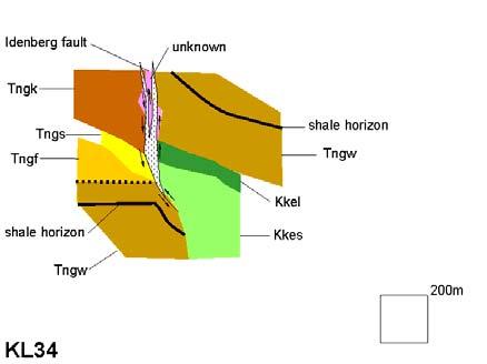
9 89 Structural setting Large-scale geometry The Waripi and Ekmai Limestone units, as well as upper sections of the Ekmai Sandstone, dominate the stratigraphy of the main mineralised zone northeast of the Idenberg Fault Zone (Figure 4-2, Figure 4-3). Much of the rock mass intersected on the southwest side of the Idenberg fault zone is undifferentiated limestone at higher levels, though it is likely to be the Kais Limestone, due to the local recognition of the Sirga Sandstone (Figure 4-2). However, the recognition of the upper Waripi sandstone member in much of the deeper drilling allows some reconstruction of the geometry of stratigraphy in the footwall of the Idenberg Fault Zone. Bedding strikes consistently at ~290 in this part of the system. Unit boundaries dip north but are concave upwards directly adjacent to the Grasberg Igneous Complex, which is intersected at the centre and northwest end of the deposit and has a near vertical contact with host rocks (Figure 4-3). Although data on the southwest side of the Idenberg Fault Zone are scarce, the strike of the upper Waripi shale/sandstone marker is observed to be similar to that on the northeast side. The Ekmai Limestone is thicker in the southeast than in the northwest, while the Waripi Limestone is thicker in the northwest than in the southeast (Figure 4-3). Thickening is coincident with inflections in the strike of the Ekmai Limestone. The distribution of marker horizons in cross section, especially the upper Waripi shale/sandstone marker, illustrate that total vertical separation across the Idenberg Fault Zone is ~600m, north side up relative to south (Figure 4-3). The Idenberg Fault Zone has an offset geometry when viewed in cross section, plan and long section (Figure 4-3). The 290 striking segments are m thick, while vertical, 300 striking segments are only 5-10m thick. (Overleaf): Figure 4-2 is a series of sections of each cross section studied during this research program. They are included to demonstrate the continuity of stratigraphy as well as the variation in exposure scale for each section. The stratigraphic patterns are derived from projection of drill traces onto flat page and so may not be strictly accurate dur to non-planar drill traces. The relative position of the shale horizon marker in the upper Waripi Limestone gives an impression on the scale of displacement across the Idenberg Fault Zone. Stratigraphic unit codes are; Tngk = Kais Limestone, Tngs = Sirga Sandstone, Tngf = Faumai Limestone, Tngw = Waripi Limestone, Kkel = Ekmai Limestone, Kkes = Ekmai Sandstone. Pink shaded areas depict areas where stratigraphic assignment is not possible, while dotted pattern depicts fault breccia zones.


10 90 Kucing Liar, Ertsberg mining district Figure 4-2 Serial sections of Kucing Liar lithology (refer Chapter 1 for section locations)


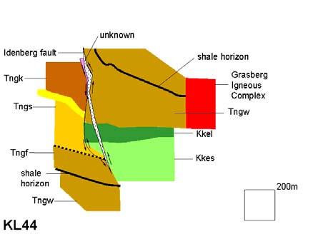

11 91 Structural setting Figure 4-2 Serial sections of Kucing Liar lithology (cont.)
12 92 Kucing Liar, Ertsberg mining district Figure 4-3 Interpretative cross sections of Kucing Liar stratigraphy from wireframes SW Offset fault zone No characteristic texture or layer to identify strata Bulging and offset fault zone Different sandstone layers must be separated by fault SW Kais limestone Sirga sandstone Faumai limestone Waripi sandstone member SW (a) (b) (c) Kais limestone Waripi limestone Idenberg Fault Zone Faumai limestone Approximate location only Idenberg Fault Zone Idenberg Fault Zone Waripi sandstone member Waripi sandstone member Waripi limestone Waripi sandstone member Bulging and offset fault zone Waripi limestone Ekmai limestone Ekmai sandstone Waripi limestone Ekmai limestone Ekmai sandstone Waripi limestone Ekmai limestone Ekmai sandstone Cross section KL22 NE Cross section KL32 Buckling of stratigraphy adjacent to GIC Buckling of stratigraphy adjacent to GIC Grasberg Igneous Complex NE Cross section KL42 Grasberg Igneous Complex NE Three representative cross sections selected from the centre and either end of the deposit (spaced roughly 500m apart, see Figure 4-4). Unlike the previous Figure 4-2, the stratigraphic contacts in this figure are not projections but are sections taken from individual wireframes that were interpreted for each unit contact from its real position in each drill trace using 3D mine environment software. The drill traces are projected onto section planes as grey lines. No vertical exaggeration. (a) A cross section through station KL22 shows relatively simple stratigraphic succession adjacent to a discrete fault offset (dotted line). Due to carbonate alteration and little exposure the exact position of the stratigraphy to the left (southwest) of the Idenberg Fault Zone (IFZ) could not be determined. (b) A section through KL32 in the centre of deposit shows a much greater exposure of the system. In this section the offset in the IFZ is much more pronounced. More drilling past the IFZ has allowed identification of the upper Waripi shale-sandstone marker horizon and subsequent overall movement on the fault zone (heavy black arrow) (c) A section through KL42 again shows the IFZ offset and displacement (heavy black arrow), as well as the position of the Grasberg Igneous Complex (GIC). Note the apparent buckling of stratigraphy adjacent to the GIC.
13 93 Structural setting Figure 4-4 Interpretative plan sections of Kucing Liar stratigraphy from wireframes (a) Low-angle truncation of stratigraphy (b) (c) LS2 Low-angle truncation of stratigraphy Bulging and pronounced offset on fault zone LS2 LS2 LS3 LS3 LS4 LS4 Variable thickness and strike of fault zone LS3 Offset of stratigraphy orthogonal to primary displacement LS4 Idenberg Fault Zone Faumai limestone Ekmai limestone Waripi sandstone member Idenberg Fault Zone Kais limestone Kais or Faumai limestone Waripi limestone Waripi sandstone member Grasberg Igneous Complex Grasberg Igneous Complex Grasberg Igneous Complex Idenberg Fault Zone Faumai limestone Approximate location only Waripi limestone Waripi limestone Ekmai limestone Ekmai limestone Ekmai sandstone Plan section PS1 3000mRL Plan section PS2 2750mRL Consistent stepping of unit contacts Plan section PS3 2500mRL Different strike of same stratigraphic unit Three representative plan sections spaced 250m apart, see Figure 4-3 for locations. The stratigraphic contacts in this figure were created from individual wireframes that were interpreted from each cross section. The locations of drill stations for each cross section are projected onto the sections for orientation purposes. The outline of the Grasberg Igneous Complex (GIC) was supplied by PT Freeport Indonesia geologist Peter Manning. (a) A plan section through 3000mRL (above sea level) shows the angular relationship between sedimentary units and the Idenberg Fault Zone (IFZ).The IFZ in this section is relatively simple. The sandstoneshale marker horizon in the Upper Waripi Limestone is shown intersecting the IFZ in the far west. (b) A section through 2750mRL (above sea level) shows the truncation of the Ekmai Limestone against the IFZ. Also apparent in the east are offsets in the Ekmai Limestone that may be an expression of minor faulting associated with the IFZ. The IFZ shows variable thickness and orientation in this section. (c) A plan at 2500mRL (a.s.l.) shows a complicated orientation of the Ekmai Limestone and a very narrow but offset IFZ. This section also indicates an offset of the stratigraphy in the footwall of the IFZ which is normal to the main fault zone.
14 94 Kucing Liar, Ertsberg mining district Figure 4-5 Interpretative longitudinal sections of Kucing Liar stratigraphy from wireframes NW NW (b) (c) NW (a) Idenberg Fault Zone Upper Waripi sandstone Inflection in bedding plunge?kais limestone?faumai limestone Approximate location only Waripi limestone Waripi sandstone member Consistent thickness of stratigraphic unit along strike Subparallel lowangle offsets in stratigraphy Significant thinning of stratigraphic unit Waripi limestone Bulge in unit thickness Waripi limestone Ekmai limestone Ekmai sandstone Waripi limestone Ekmai limestone Waripi sandstone member Waripi sandstone member Ekmai sandstone Location of contact between two units is unknown Raft of Ekmai limestone in fault zone SE Long section LS2 Bulging offset fault zone Idenberg Fault Zone?Faumai limestone SE Unknown position or attitude of contact Long section LS3 Consistent thickness of stratigraphic unit SE Long section LS4 Three representative long sections of the stratigraphic wireframes created from 3D drilling data. Intersections of stratigraphic wireframes with the section plane are indicated by continuous lines. The sections are vertical and orientated perpendicular to the primary drilling azimuth (see Figure 4-3 and 4-4). (a) Is generally in the footwall of the Idenberg Fault Zone (IFZ) which can be seen in the far left of the section. (b) A section through the middle of the deposit shows thickening of the Ekmai Limestone as well as a bulging offset in the IFZ which is not equivalent to that observed in cross sections in Figure 4-3. The total displacement across the IFZ is indicated by a thick double-headed arrow. (c) A section close to the GIC (see Figure 4-3) shows relatively simple stratigraphy with minor offsets and thinning.
15 95 Structural setting Hydrothermal mineral distribution This section covers the local-scale controls on fluid infiltration as well as the deposit-scale controls. The structural controls of fluid flow within Kucing Liar are analysed via meso- (hand sample), macro- (single drill hole) and mega-scale (drill fan) patterns of hydrothermal mineral development. Local controls are determined by down hole plots of mineral abundance and lithological data while deposit-scale controls are identified by comparing alteration distribution models with lithological models presented in the previous section. Patterns of hydrothermal alteration Fluid flow was not uniform through Kucing Liar wall rocks, as fluids were structurally controlled at various scales. The patterns of mineral distribution are illustrated by down hole logs which display the abundances of each hydrothermal mineral (Figure 4-6). The three examples shown illustrate respectively, the Idenberg fault zone in relatively unaltered hosts (KL32-01), a complex fault system and complicated stratigraphy (KL32-04), and a simple fault system accompanied by simple stratigraphy (KL32-05). KL32-01, KL32-04 and KL32-05 were all drilled toward 219º at 0, 45 and 60º respectively. In KL32-01, sedimentary rocks on the north side of the fault are generally unaltered except for low abundance calcite ± magnetite alteration of the upper Waripi sandstone member that elsewhere commonly contains quartz alteration. KL32-04 was drilled at - 45 and intersected two fault zones delineated by zones where the lithology is generally unrecognisable. KL32-05 was drilled at a steeper angle and intersected deeper sections of the Idenberg Fault Zone. Discrete intersections dominated by single minerals extend in length from 5-100m along a drill hole and are commonly 10-20m. Contacts between such zones dominated by different minerals are commonly sharp. Some exceptions include gradual and sympathetic abundance changes between K-feldspar and quartz alteration in the Ekmai Limestone (KL32-04, m). However, contacts of the K-feldspar-quartz with magnetite-sulphide and clinopyroxene are commonly sharp.
16 96 Kucing Liar, Ertsberg mining district Figure 4-6 Lithological patterns and mineral abundances in representative drill holes KL32-01 Idenberg Fault in relatively unaltered hosts This figure is intended to demonstrate three patterns of lithology and alteration encountered in drilling conducted on the same cross section (KL32). See Figure 1-12 for the precise angular relationships between each drillhole. Ornamentation is based on identified lithology while the unit codes are interpreted based on sequence of lithology. See Appendix V for mineral abbreviations and details of logging process. Stratigraphic unit codes are; Tngw = Waripi Limestone, Tngl = undifferentiated New Guinea Limestone Group limestone, Kkel = Ekmai Limestone, Kkes = Ekmai Sandstone. Dashed lines mark the upper and lower boundaries of unrecognised lithologies that are interpreted to represent fault zones. An asterisk is used to identify the location of the upper Waripi sandstone member, which is used to establish the total vertical offset.
17 97 Structural setting Figure 4-6 (cont.) KL32-05 Simple faulted stratigraphic sequence
18 98 Kucing Liar, Ertsberg mining district Figure 4-6 (cont.) KL32-04 Complex fault and offset stratigraphy
19 99 Structural setting Large-scale mineral distributions Clinopyroxene ± garnet skarn (see Chapter 3) is developed as thick (~20-50m-scale) lenses in the lower Waripi Limestone and Ekmai Limestone, parallel to the folded stratigraphy and are apparently truncated up dip by the Idenberg Fault Zone (Figure 4-7). Bodies with moderate to high preserved abundances of skarn-related minerals form a series of stacked lenses that occupy the lower Waripi and Ekmai Limestones, paralleling the bedding (Figure 4-7). Semi-concordant skarn rocks in the southeast of the deposit are concentrated in the lower Waripi Limestone and subordinate positions in the Ekmai Limestone (Figure 4-7). Skarn alteration does not persist to the northwest past the apparent truncation and thinning of the Ekmai Limestone (Figure 4-7). Early skarn is zoned with garnet occupying the primary channelways surrounded by clinopyroxene (cf. small-scale features illustrated in Section 3.2.1). Similarly, a large skarn body dominated by garnet occurs within the Idenberg Fault Zone. Skarn alteration maintains a constant thickness of 50m for 500m along strike, and maintains a constant position 50m above the base of the Waripi Limestone. The low density of data in these regions did not allow confident constructions of volumetric models for skarn mineral development in the footwall sequence to the southwest of the Idenberg Fault Zone. Volumes of preserved moderate abundances of K-feldspar ± biotite are tightly restricted to the Ekmai Limestone (Figure 4-8). In cross section, K-feldspar ± biotite rocks are concentrated wholly within the Ekmai Limestone. Biotite alteration is most extensive where the Ekmai Limestone is thickest but is also concentrated in deeper portions of the Ekmai Sandstone and associated with the Idenberg Fault Zone (Figure 4-8). By contrast, moderately magnetite-rich rocks are prominent as a single concentration 20m thick along the base of the Waripi Limestone, extending along most of the identified strike extent (Figure 4-9). Significantly, the magnetite rocks extend into the Grasberg Igneous Complex where they appear to be portioned at the Grasberg Igneous Complex boundary, the first alteration to appear as such (Figure 4-9). At the deepest levels in the down-faulted stratigraphic package, magnetite is concentrated in limestone, assumed to be Faumai Limestone, above the upper Waripi sandstone member (Figure 4-9).
20 100 Kucing Liar, Ertsberg mining district Retrograde skarn minerals tremolite-actinolite and serpentine have a similar distribution to magnetite, though details of any stratigraphical or structural control are not visible. Quartz alteration is concentrated into stratigraphic layers abutting the Idenberg Fault Zone (Figure 4-10). Well-defined bodies of quartz-dominant material 10-50m thick were identified in drill core and are found to extend up to 500m along strike (Figure 4-10). Quartz alteration is less well developed in the east than in the west. Quartz alteration also occurs as a discrete package in the upper Waripi sandstone member. Moderate to high abundances of sulphides are concentrated within the Idenberg Fault Zone (i.e. broadly coincident with quartz alteration) (Figure 4-11). Additional smaller concentrations of sulphides are present along major stratigraphic contacts, particularly the Ekmai Limestone contacts. Sulphide concentrations are continuous for hundreds of metres along strike (Figure 4-11). Sulphide development is not continuous from the Idenberg Fault Zone to the Grasberg Igneous Complex. The independent development of chalcopyrite and covellite-bearing mineralisation is reconfirmed in models of their spatial distribution (Figure 4-11). Distributions of covellite-bearing mineralisation are distinctly concentrated about the Idenberg Fault Zone as well as in the adjacent Ekmai Limestone. In contrast, chalcopyrite-bearing mineralisation is concentrated along the Ekmai Limestone and is continuous into the Grasberg Igneous Complex.

 A plan section through 2,750m demonstrates that the skarn development does not envelop the GIC. The asymmetric zoning of skarn across the IFZ relative to elevation is also clear.")
21 101 Structural setting Figure 4-7 Distribution of calcite, clinopyroxene, garnet, humite and phlogopite (a) (b) (c) Sections of skarn alteration differentiated by the various minerals identified in Chapter 3. The Grasberg contact was provided by Freeport geologists. (a) A cross section through station KL32 shows the stratiform nature due to lithological layer control of clinopyroxene and garnet accumulations as well as zoning pattern of garnet inside clinopyroxene. (b) A plan section through 2,750m demonstrates that the skarn development does not envelop the GIC. The asymmetric zoning of skarn across the IFZ relative to elevation is also clear. (c) A long section perpendicular to cross sections demonstrates once more the stratiform nature of skarn as well as the zoning pattern grading from proximal garnet to clinopyroxene to distal calcite ± magnetite. See (a) & (b) for location.


22 102 Kucing Liar, Ertsberg mining district Figure 4-8 Distribution of dominant K-feldspar + biotite alteration (a) (b) (c) Sections of the distributions of the various potassic alteration group minerals identified in Chapter 3. The Grasberg contact was provided by Freeport geologists. (a) A cross section through station KL32 shows the stratiform nature due to lithological layer control of K-feldspar and biotite accumulations. Deeper sections of Kucing Liar are biotite rich about the IFZ. (b) A plan section through 2,750m demonstrates the lithological control as well as a suggestion of zoning from inboard biotite to more distal K-feldspar. (c) A long section perpendicular to cross sections demonstrates once more the lithological control highlighted in Chapter 3 as well as the zoning pattern grading from proximal biotite to more distal K-feldspar. See (a) & (b) for location.
 control on magnetite and retrograde skarn and also that retrograde skarn and some magnetite is not stratiform.")
 A plan section through 2,750m demonstrates the same connectivity with the GIC.")
23 103 Structural setting Figure 4-9 Distribution of extensive magnetite and tremolite-actinolite alteration (a) (b) (c) Sections of the distributions of magnetite and retrograde skarn alteration identified in Chapter 3 demonstrate the strong lithological (or stratigraphic contact) control on magnetite and retrograde skarn and also that retrograde skarn and some magnetite is not stratiform. The Grasberg contact was provided by Freeport geologists. (a) A cross section through station KL32 shows that a large amount of magnetite is juxtaposed with the GIC. The section demonstrates a hydrothermal connection between the GIC and Kucing Liar during magnetite alteration (b) A plan section through 2,750m demonstrates the same connectivity with the GIC. (c) A long section perpendicular to crosssections demonstrates once more the strong stratigraphical control. See (a) & (b) for location.


24 104 Kucing Liar, Ertsberg mining district Figure 4-10 Distribution of rocks dominated by quartz, muscovite and anhydrite alteration (a) (b) (c) Sections of the distributions of quartz, anhydrite and talc-muscovite alteration identified in Chapter 3 demonstrate weak lithological control on quartz alteration but the disparate nature of this apparently temporally related assemblage. (a) A cross section through station KL32 shows well the lithological control on quartz, where the stratigraphy is adjacent t the IFZ. The upper Waripi sandstone member has strongly partitioned some quartz alteration. Anhydrite distributions are very similar to that of tremoliteactinolite but show no clear structural control. (b) A plan section through 2,750m suggests a parallel structure at the margin of GIC has concentrated quartz alteration. (c) A long section perpendicular to cross sections demonstrates once more the strong stratigraphical control. See (a) & (b) for location.

 A cross section through station KL32 shows the intensity of pyrite and covellite development in the IFZ offset as well as the influence of the Ekmai")

25 105 Structural setting Figure 4-11 Distribution of ore sulphides, pyrite, chalcopyrite and covellite (a) (b) (c) Sections of the distributions of pyrite, chalcopyrite and covellite demonstrate the strong influence of the IFZ and more subtle lithological control on ore minerals as well as a zoning pattern about the IFZ of proximal covellite and distal chalcopyrite. (a) A cross section through station KL32 shows the intensity of pyrite and covellite development in the IFZ offset as well as the influence of the Ekmai Limestone. (b) A plan section through 2,750m shows the most intense pyrite alteration is opposite the GIC. Note that the contact zone of Kucing Liar and the GIC where magnetite and retrograde skarn are concentrated is occupied by high chalcopyrite concentrations. (c) A long section perpendicular to cross sections further demonstrates the zoning pattern of ore minerals. See (a) & (b) for location.
26 106 Kucing Liar, Ertsberg mining district 4.2 LARGE-SCALE CONTROLS ON FLUID INFILTRATION The data in this chapter will show that the Kucing Liar hydrothermal system was related to a major structural offset in the Idenberg Fault Zone, which is adjacent to a significant lithological contrast Structural geometry of Kucing Liar alteration The combination of specific rock types and marker horizons (Chapter 2) has enabled construction of a lithological model for the mineralised zone. Models of these data indicate that Kucing Liar lies within the north dipping limb of a syncline, although no fold closures are evident in the study area. Adjacent to the Grasberg Igneous Complex the bedding is folded against the intrusion contact, suggesting forceful intrusion. The host stratigraphy has been truncated at a very shallow angle to strike by a steeply dipping fault zone. The fault zone is named the Idenberg Fault Zone and contains several steeply northeast dipping narrow structures that are connected by wide zones of brecciation. The zone of displacement follows both the narrow structures and wide zones to produce a series of offsets within the fault zone. The displaced portion of Kucing Liar on the southwest of the Idenberg Fault Zone is difficult to analyse due to very low data densities. The same rock types are encountered in the footwall of the Idenberg Fault Zone, though skarn is more prevalent than other alteration types. The mineral distribution data indicate the Idenberg Fault Zone focussed the entire system while a series of complex offsets in the fault zone provided local controls, specifically on garnet and sulphide distributions. Specific alteration assemblages are concentrated along the lower Waripi and Ekmai Limestone contacts, as well as within the Idenberg Fault Zone, especially within offsets of the fault. Within the mineralised zone hydrothermal alteration occupies the upper sandstone member of the Waripi Limestone, the lower Waripi Limestone, the Ekmai Limestone and also extends downwards into the Ekmai Sandstone. Skarn alteration tends to be stratiform and is concentrated in the Ekmai Limestone and lower half of the Waripi Limestone. Humite-forsterite
27 107 Structural setting ± serpentine and clinopyroxene ± tremolite-actinolite are restricted to the dolomitic Waripi Limestone (see Chapter 2) within the main mineralised zone and appear to stratiform and interlayered, perhaps reflecting the original distribution of dolomite and calcite in the limestone unit. Garnet and magnetite are localised within the Waripi Limestone along its lower contact with the Ekmai Limestone and to a lesser extent along the base of the Ekmai Limestone. Small concentrations of garnet are also localised along the upper skarn contact within the Waripi Limestone. K-feldspar ± biotite, along with related quartz veins, is generally restricted to the Ekmai Limestone and Ekmai Sandstone though biotite also formed independently within narrow portions of the Idenberg Fault Zone below the elevation of the main mineralised zone. Quartz and sulphide alteration have very similar distributions that appear to parallel the steeply dipping structures within the Idenberg Fault Zone and are concentrated about a large-scale offset in the fault zone. Quartz and sulphide are structurally distinct from other alteration assemblage, as they do not form large stratiform bodies. The change in alteration distribution from skarn to potassic to silica-pyrite indicates a change in structural controls that will be analysed in the next section. The relationship between chalcopyrite and covellite mineralisation in Kucing Liar and the Grasberg porphyry system has not been comprehensively tested, though the two systems have similar ore assemblages, there are some grounds for believing the two are distinct systems, and will be further discussed in Chapter 9. The data indicate mineralisation that is zoned with respect to fluid flow. Mertig et al., (1994), Hefton et al., (1995), and Rubin and Kyle (1998) have described vertical zonation of alteration and mineralisation in the magnesian skarn deposits of the EESS, formally referred to as GBT- IOZ-DOZ (see Chapter 1). The focus of fluid flow at Kucing Liar was the Idenberg Fault Zone, and in particular offset within it, and fluids probably flowed upwards and along stratigraphic contacts to that feature. Fluids may then have migrated within the Idenberg Fault Zone to higher elevations. In a model where covellite formation is at least partly contemporaneous with, though spatially distinct from, chalcopyrite, the data suggest that chalcopyrite ± pyrite was accompanied by and locally overprinted by covellite ± pyrite, which is restricted to the high flow areas. Both of
28 108 Kucing Liar, Ertsberg mining district these forms of copper mineralisation were replaced in the core of the Idenberg Fault Zone by a package of pyrite ± chalcopyrite ± covellite. Pyrite, chalcopyrite and covellite core are overprinted by galena and sphalerite Driving forces of fluid flow Fluid infiltration through rocks may be via primary or secondary porosity. Primary porosity is a function of the grain size, degree of cementation and distribution of the wall rocks, while secondary porosity is that which is created during deformation or alteration in the absence of deformation. The very fine-grained texture of rock samples, particularly pyroxene and feldspar, indicate derivation from rapid deposition at numerous nucleation sites, which can result from high fluid fluxes that are conducive to supersaturation (Einaudi et al., 1981). Additionally, pervasive fluid flow such as is observed to have occurred during skarn and potassic (K-feldspar ± biotite) alteration is inferred to occur along microcracks and grain-boundary porosity (Oliver, 1996). Pervasive fluid flow produces uniform replacement of wall rocks, referred to as penetrative alteration (Chapter 3). Widespread penetrative alteration is indicative of low fluid pressures and will typically be associated with relatively high fluid fluxes as compared to channelled flow (Oliver, 1996). Channelled fluid flow occurs along fractures in wall rocks but is accompanied by substantial infiltration into the local wall rocks, typically resulting in a mineralogical selvedge (Oliver, 1996). The progressively declining scales of penetrative alteration accompanied by increased fracture selvedge and infill indicate that fluid flow became more and more channelled accompanied by increasing fluid pressures. There are also indications that the amount of channelled fluid flow increased with time, evidenced by the increase in infill relative to alteration and the decrease in penetrative alteration in later stages of the paragenesis (Chapter 3). Within a fault zone, fluid migration occurs from zones of high interstitial pressure and high strain (contraction zone) to zones of low interstitial pressure (dilation zone) (Guha et al., 1983). Flow localization within faults and shear zones occurs in areas of highest fracture aperture and fracture density, such as damage zones associated with fault jogs, bends and splays (Cox et al., 2001).
29 109 Structural setting Offsets are thus favourable sites for fluid flow due to complex geometry created by the large amount of wall rock partings and intersections of variably oriented fractures. Fluid flow in a fault network is governed by creation of permeability through movement. Where high fluid pressures produce low effective confining pressures, grain scale crack growth significantly increases the permeability of the active shear zone relative to their host rocks (Cox et al., 2001). Thus, secondary permeability is created by high pore fluid pressure regimes, which favour fracture growth (Cox et al., 2001). Mineral-filled fractures in hydrothermal systems indicate tensile effective stress states, and thus, fluid pressures greater than σ3 (lithostatic load) (Cox et al., 2001). Sustained hydrothermal flow must be accompanied by repetitive and continued wall rock fracturing given that mineral sealing is rapid compared to the lifetimes of hydrothermal systems (Cox et al., 2001). Consequently, sustained fluid flow occurs only in active structures where permeability is repeatedly renewed. Fault motion is accommodated by earthquake-related rupturing (Sibson, 2001) and is accompanied by significant fluid redistribution that occurs throughout the aftershock phase following large earthquakes (Cox et al., 2001). Secondary porosity related to lithological layering may also be produced during folding as deformation of heterogeneous rocks creates dilatancy due to competency contrast, as well as large variations in pore fluid pressure (P f ), leading to brecciation along these contacts (Oliver et al., 2001). Thus deformation can explain brecciation along the base of the Waripi Limestone. In similar fashion to Kucing Liar, the Big Gossan deposit is concentrated in breccia bodies within the lower Waripi Limestone near the contact with the Ekmai Limestone, which was altered to pyroxenefeldspar and biotite-feldspar hornfels and also contains local garnet-pyroxene skarn (Meinert et al., 1997). The preference for the Ekmai Limestone as a host for quartz vein arrays may also be derived from ground preparation due to contact metamorphism of the shaly limestone, as brittle calc-hornfels are easily fractured during deformation (Einaudi et al., 1981).
This file is part of the following reference: Access to this file is available from:
 This file is part of the following reference: New, Brian (2006) Controls of copper and gold distribution in the Kucing Liar deposit, Ertsberg mining district, West Papua, Indonesia. PhD thesis, James Cook
Drill locations for the 2015 program are highlighted in the geology map below.
 2015 Exploration Program The exploration program plan at KSM for 2015 was designed to improve the understanding of block cave targets and support engineering/environmental aspects of development scenarios.
Stope Stability at the Big Gossan Skarn Deposit, Papua, Indonesia
 Stope Stability at the Big Gossan Skarn Deposit, Papua, Indonesia Katerina Sari, Geoffrey de Jong, Pormando Silalahi, Wahyu Sunyoto Underground Geology Operation, PT Freeport Indonesia PACRIM 2015 Hong
Figure 1: Location of principal shallow conductors at Alpala (anomalies C0-C10; 5 Ohm/m surfaces, red) and shallow zones of electrical chargeability
 and shallow zones of electrical chargeability") Figure 1: Location of principal shallow conductors at Alpala (anomalies C0-C10; 5 Ohm/m surfaces, red) and shallow zones of electrical chargeability (85 msecs, yellow-green) shown on iso-surfaces of MVI
Figure 1: Location of principal shallow conductors at Alpala (anomalies C0-C10; 5 Ohm/m surfaces, red) and shallow zones of electrical chargeability (85 msecs, yellow-green) shown on iso-surfaces of MVI
Answers: Internal Processes and Structures (Isostasy)
") Answers: Internal Processes and Structures (Isostasy) 1. Analyse the adjustment of the crust to changes in loads associated with volcanism, mountain building, erosion, and glaciation by using the concept
Answers: Internal Processes and Structures (Isostasy) 1. Analyse the adjustment of the crust to changes in loads associated with volcanism, mountain building, erosion, and glaciation by using the concept
CSA Mine Observations Applied to the Development of Regional Exploration Models
 CSA Mine Observations Applied to the Development of Regional Exploration Models 1 Introduction Recent work completed by the geology team has resulted in an improved understanding of the CSA mine system
APPENDIX C GEOLOGICAL CHANCE OF SUCCESS RYDER SCOTT COMPANY PETROLEUM CONSULTANTS
 APPENDIX C GEOLOGICAL CHANCE OF SUCCESS Page 2 The Geological Chance of Success is intended to evaluate the probability that a functioning petroleum system is in place for each prospective reservoir. The
This file is part of the following reference: Access to this file is available from:
 This file is part of the following reference: New, Brian (2006) Controls of copper and gold distribution in the Kucing Liar deposit, Ertsberg mining district, West Papua, Indonesia. PhD thesis, James Cook
SECOND DRILL HOLE IHAD2 INTERSECTS MINERALIZED TAPLEY HILL FORMATION AND MINERALIZED BASEMENT IRON FORMATION
 Suite 304, 22 St Kilda Road St Kilda Vic 3182 Ph: +61 3 9692 7222; Fax: +61 3 9529 8057 For Immediate Release 14 th September 2007 SECOND DRILL HOLE IHAD2 INTERSECTS MINERALIZED TAPLEY HILL FORMATION AND
This file is part of the following reference: Access to this file is available from:
 This file is part of the following reference: New, Brian (2006) Controls of copper and gold distribution in the Kucing Liar deposit, Ertsberg mining district, West Papua, Indonesia. PhD thesis, James Cook
DISCOVERY OF MINERALISED PORPHYRY & MAGNETITE-COPPER-GOLD AT KAMARANGAN
 MEDUSA MINING LIMITED ABN: 60 099 377 849 Unit 7, 11 Preston Street Como WA 6152 PO Box 860 Canning Bridge WA 6153 Telephone: +618-9367 0601 Facsimile: +618-9367 0602 Email: admin@medusamining.com.au Internet:
Discovery of Thick Zone of Magnetite-Rich M Veins Strengthens Potential for Nearby Porphyry
 Thursday s Gossan Copper-Gold Porphyry Diamond Drilling Update Discovery of Thick Zone of Magnetite-Rich M Veins Strengthens Potential for Nearby Porphyry ~100m intercept of magnetite-rich M -veins and
Observations on a Veined Section of Core Drilled at Blockhouse, Lunenburg County
 Report of Activities 2016-17 53 Observations on a Veined Section of Core Drilled at Blockhouse, Lunenburg County R. F. Mills and A. MacKay 1 The Blockhouse gold district (NTS 21A/08) lies approximately
Geology, Alteration and. Petrogenesis
 The Mutooroo Copper Deposit: Geology, Alteration and Petrogenesis Graham S. Teale Consultant t Andrew T. Price Havilah Resources NL The speaker would like to thank Havilah Resources NL for the opportunity
COPPERSTONE RESOURCES AB INTERCEPTS ZONE OF CHALCOPYRITE-ARSENOPYRITE- BORNITE MINERALIZATION AT SVARTLIDEN IN FIRST DEEP DRILLHOLE FROM 720m-810m
 COPPERSTONE RESOURCES AB INTERCEPTS ZONE OF CHALCOPYRITE-ARSENOPYRITE- BORNITE MINERALIZATION AT SVARTLIDEN IN FIRST DEEP DRILLHOLE FROM 720m-810m In mid-january 2017 Copperstone Resource published a geological
Update on Chillagoe Mining District Research: Dec 7, 2017
 Update on Chillagoe Mining District Research: Dec 7, 2017 Peter Illig 1, Zhaoshan Chang 1 1 EGRU James Cook University, Townsville QLD 4811, Australia Introduction to Chillagoe Deposits Regional introduction
THE HETEROGENEOUS STRUCTURE OF FAULT ZONES WITHIN CARBONATE ROCKS: EVIDENCE FROM OUTCROP STUDIES AND IMPLICATIONS FOR FLUID FLOW
 THE HETEROGENEOUS STRUCTURE OF FAULT ZONES WITHIN CARBONATE ROCKS: EVIDENCE FROM OUTCROP STUDIES AND IMPLICATIONS FOR FLUID FLOW C.G. Bonson*, J.J. Walsh, C. Childs, M.P.J. Schöpfer & V. Carboni Fault
Petrological Studies by Terry Leach at the North Carlin Trend, Nevada. Keith Bettles October 17, 2008
 Petrological Studies by Terry Leach at the North Carlin Trend, Nevada Keith Bettles October 17, 2008 North Carlin Trend From 1999 to 2003 Terry Leach studied the Betze and Meikle ore bodies for Barrick
Exploring in the last frontier: Skarn mineralisation, Attunga District, NSW
 BROVEY MAPPING SERVICES Exploring in the last frontier: Skarn mineralisation, Attunga District, NSW Latest exploration findings and interpretations Nancy Vickery, Joshua Leigh and Michael Oates Outline
Press Release Azimut and Partners announce Drilling Results from Eleonore South Gold Property, James Bay region, Quebec
 For immediate release December 17, 2018 Symbol: AZM. TSX Venture Press Release Azimut and Partners announce Drilling Results from Eleonore South Gold Property, James Bay region, Quebec Longueuil, Quebec
For personal use only
 ASX ANNOUNCEMENT 2nd February 2012 PROMISING DRILLING RESULTS FROM KUINI PROSPECT IN ACEH ASX: PSP SHARE INFORMATION Issued Shares: 346.54m Unlisted Options: 20.95m BOARD OF DIRECTORS Chairman & MD: M.
MINERAL DEPOSITS OF THE COBAR BASIN
 MINERAL DEPOSITS OF THE COBAR BASIN 360 hard rock deposits in Cobar Basin Cu, Au, Ag, Pb, Zn combinations and quartz-au veins Cobar 23 major deposits in Cobar Basin World class Endeavor mine World class
it AUSIMM COBAR MINING SEMINAR
 Straits Resources Limited it AUSIMM COBAR MINING SEMINAR Brownfields Exploration at Girilambone: Understanding the Mineralised Systems August 2010 Phil Shields / Phil Jones LOCATION TRITTON OPERATIONS
THE GEOLOGY OF THE ENDEAVOR MINE: AN UPDATE
 THE GEOLOGY OF THE ENDEAVOR MINE: AN UPDATE Peter Nicholson, Vanadis Mares and Don Endeavor Operations Pty Ltd, via Louth Road, Cobar, NSW 2835. Key Words: zinc, lead, silver, Cobar, geology Introduction
Lab 6 - Identification of Metamorphic Rocks
 Lab 6 - Identification of Metamorphic Rocks Page - Introduction Metamorphic rocks are the third great rock group. The term meta means to change and morph means form. Metamorphic rocks are rocks who have
Wind Mountain Project Summary Memo Feeder Program
 A Manex Resource Group Company Wind Mountain Project Summary Memo Feeder Program J.A. Kizis, Jr., February 07, 2018 Assays have been received for both holes drilled at Wind Mountain during late 2017 and
ASX Announcement. 28 January Drill results indicate large Porphyry Copper Gold System at Peenam
 ASX Announcement 28 January 2010 Drill results indicate large Porphyry Copper Gold System at Peenam Highlights: 270 metres of visible copper (gold) mineralisation in first diamond core hole at Peenam Prospect
Copperstone Technical Report Update on 2018 Drilling Campaign
 2018 Copperstone Technical Report Update on 2018 Drilling Campaign Chris McKnight Copperstone Resources AB 5/16/2018 Highlights Mineralisation consisting of interspersed chalcopyrite veins (assay results
GEOLOGICAL MAPPING OF SKARNS ON THE SHEEP AND EWE CLAIMS, TURNAGAIN RIVER, B.C. DURING THE 1979 SUMMER SEASON
 GEOLOGICAL MAPPING OF SKARNS ON THE SHEEP AND EWE CLAIMS, TURNAGAIN RIVER, B.C. DURING THE 1979 SUMMER SEASON CLAIMS: Sheep 1 to 4 Ewe 1, 3, 4 to 8 Lamb 12 Fraction Liard Mining Division, B.C. NTS 104
Practice Test Rocks and Minerals. Name. Page 1
 Name Practice Test Rocks and Minerals 1. Which rock would be the best source of the mineral garnet? A) basalt B) limestone C) schist D) slate 2. Which mineral is mined for its iron content? A) hematite
For personal use only
 ASX ANNOUNCEMENT 6th February 2012 HIGH GRADE AU-CU INTERSECTIONS FROM KUINI PROSPECT IN ACEH ASX: PSP SHARE INFORMATION Issued Shares: 346.54m Unlisted Options: 20.95m BOARD OF DIRECTORS Chairman & MD:
Quaternary clays alluvial sands of the Shepparton Formation overlie the basement rocks.
 NAGAMBIE GOLDFIELD Regional Geological Setting The Nagambie Project is located within the Melbourne Structural Zone of Victoria. The lithologies range in age from the Upper Silurian Broadford Formation
Chapter 8 Lecture. Earth: An Introduction to Physical Geology. Twelfth Edition. Metamorphism. Rocks. Tarbuck and Lutgens Pearson Education, Inc.
 Chapter 8 Lecture Earth: An Introduction to Physical Geology Twelfth Edition Metamorphism and dmetamorphic Rocks Tarbuck and Lutgens Chapter 8 Metamorphic Rocks What Is Metamorphism? Metamorphism means
Metamorphic Petrology. Jen Parks ESC 310, x6999
 Metamorphic Petrology Jen Parks ESC 310, x6999 jeparks@sciborg.uwaterloo.ca Definition of Metamorphism The IUGS-SCMR SCMR definition of metamorphism: Metamorphism is a subsolidus process leading to changes
core samples and soil focusing on geochemistry and gold-sulphide paragenesis (Gunn et al.,
 CHAPTER 1 INTRODUCTION 1.0 Introduction Penjom Gold Mine (PGM) is the biggest gold mine in Malaysia and has produced more than 45 tonnes (1.4 Moz) of gold since 1997. As in 2014, Penjom still has resources
Big Island Field Trip
 Big Island Field Trip Space Still Available Group Airline Tickets May be available if enough people sign on If interested send email to Greg Ravizza Planning Meeting Next Week Will
Chapter 7 Metamorphism, Metamorphic Rocks, and Hydrothermal Rocks
 Chapter 7 Metamorphism, Metamorphic Rocks, and Hydrothermal Rocks Copyright The McGraw-Hill Companies, Inc. Permission required for reproduction or display. Metamorphism What happens to rocks that are
Metamorphism (means changed form
 Metamorphism (means changed form) is recrystallization without melting of a previously existing rock at depth in response to a change in the environment of temperature, pressure, and fluids. Common minerals
Regional geology map showing drill holes completed to date and hole RZDDH10 08 in progress, IP Chargeability anomalies hatched.
 Alteration Haloes Alteration facies in the Suarez-Misahuallí basin on the east side of the Rio Zarza gold project are complex, as they oerlap in time and space, are the result of weathering, diagenetic,
Prof. Tejas S Patil Dept Of Geology M.J.College.
 Prof. Tejas S Patil Dept Of Geology M.J.College. Metamorphic rocks When rocks are baked by heat of molten magma or squeezed by the movements of huge tectonic plates or by the pressure of overlying thick
ASX / MEDIA RELEASE 6 MAY MILE SILVER-LEAD-ZINC DISCOVERY; HIGH GRADE SILVER-GOLD IN ROCK CHIPS AT RUBY SILVER
 ASX / MEDIA RELEASE 6 MAY 2011 4-MILE SILVER-LEAD-ZINC DISCOVERY; HIGH GRADE SILVER-GOLD IN ROCK CHIPS AT RUBY SILVER Highlights: Silver-lead-zinc discovery at 4-Mile; mineralisation intersected in all
New Deep Inferred Resources at Tara Mine
 New Deep Inferred Resources at Tara Mine Summary Deep drilling, over the period 2012-2016, on a seismic exploration target south of the Tara Mine, has intersected a new zone of Zn-Pb mineralisation with
CHAPTER 3.3: METAMORPHIC ROCKS
 CHAPTER 3.3: METAMORPHIC ROCKS Introduction Metamorphism - the process of changes in texture and mineralogy of pre-existing rock due to changes in temperature and/or pressure. Metamorphic means change
WAMUNYU EDWARD MUREITHI I13/2358/2007
 WAMUNYU EDWARD MUREITHI I13/2358/2007 Olkaria geothermal area is situated south of Lake Naivasha on the floor of the southern segment of the Kenya rift. The geology of the Olkaria Geothermal area is subdivided
For personal use only
 HIGHLIGHTS THIS QUARTER EXPLORATION Very strong zinc-silver-lead (Zn-Ag-Pb) mineralisation confirmed in 2 sampling programs (Program 1 and Program 2) at the Riqueza Project. Two highly prospective Zn-Ag-Pb
Structural Evolution of the Keno Hill Ag-Pb-Zn mining district, Yukon
 Structural Evolution of the Keno Hill Ag-Pb-Zn mining district, Yukon Simon D. Craggs, David R. Lentz and Joseph C. White Introduction The Keno Hill Ag-Pb-Zn mining district is located in the central Yukon,
Engineering Geology ECIV 3302
 Engineering Geology ECIV 3302 Instructor : Dr. Jehad Hamad 2019-2018 Chapter (7) Metamorphic Rocks Chapter 7 Metamorphism and Metamorphic Rocks Metamorphism The transition of one rock into another by temperatures
MULTIPLE >10% ZINC IN NEW RASTRILLO DEPOSIT - RIQUEZA
 22 February 2018 HIGHLIGHTS MULTIPLE >10% ZINC IN NEW RASTRILLO DEPOSIT - RIQUEZA Multiple channel samples in Callancocha area return very high zinc (Zn), silver (Ag) and lead (Pb) grades Peak Zn sample
(A.B.N )
") P.O. Box 7996 Telephone: (07) 5592 2274 Gold Coast Mail Centre Facsimile: (07) 5592 2275 Queensland 9726 Email: info@tasgold.com.au AUSTRALIA Internet: www.tasgold.com.au 2 nd December 2005 Australian
P.O. Box 7996 Telephone: (07) 5592 2274 Gold Coast Mail Centre Facsimile: (07) 5592 2275 Queensland 9726 Email: info@tasgold.com.au AUSTRALIA Internet: www.tasgold.com.au 2 nd December 2005 Australian
Metamorphism: summary in haiku form
 Metamorphism & Metamorphic Rocks Earth, Chapter 8 Metamorphism: summary in haiku form Shape-shifters in crust. Just add heat and/or pressure. Keep it solid please! What Is Metamorphism? Metamorphism means
Data Company ,068.5 Ardala No Reasonable Anglo American Ardala Yes Reasonable YAMAS/Rio Tinto JV Goldfields JV 2011
 JORC Table 1* Ariana/Eldorado JV Salinbaş-Ardala Project The table below is a description of the assessment reporting criteria used in the Salinbaş-Ardala Project Mineral estimation that reflects those
VECTORING VOLCANOGENIC MASSIVE SULPHIDE MINERALIZATION AT THE RAINDROP ZONE, SNOW LAKE (NTS 63K16), MANITOBA by G.H. Gale
, MANITOBA by G.H. Gale") GS-8 VECTORING VOLCANOGENIC MASSIVE SULPHIDE MINERALIZATION AT THE RAINDROP ZONE, SNOW LAKE (NTS 63K16), MANITOBA by G.H. Gale Gale, G.H. 2002: Vectoring volcanogenic massive sulphide mineralization at
GS-8 VECTORING VOLCANOGENIC MASSIVE SULPHIDE MINERALIZATION AT THE RAINDROP ZONE, SNOW LAKE (NTS 63K16), MANITOBA by G.H. Gale Gale, G.H. 2002: Vectoring volcanogenic massive sulphide mineralization at
ASX Announcement NAKRU DRILLING AND TRENCHING INTERSECTS 11 METRES AT 2.84 G/T GOLD AND 28.4 METRES AT 1.1% COPPER
 ADDRESS PHONE PO Box 6965 +61(07) 5592 1001 Gold Coast Mail Centre FAX Qld 9726 Australia +61 (07) 5592 1011 EMAIL ABN 54 126 490 855 info@coppermoly.com.au WEBSITE www.coppermoly.com.au ASX Announcement
Carrapateena Mineral Resources Explanatory Notes April OZ Minerals Limited. Carrapateena Mineral Resources Statement April
 OZ Minerals Limited Carrapateena Mineral Resources Statement April 14 2011 CARRAPATEENA MINERAL RESOURCE STATEMENT April 14, 2011 The Carrapateena Resource Statement relates to an upgrading to an Inferred
Summary. Introduction. Observations and Interpretations
 Lower McMurray Formation sinkholes and their fill fabrics: effects of salt dissolution collapse-subsidence across the northern Athabasca oil sands deposit Paul L. Broughton, Chevron Canada Resources, Calgary,
Kalman Mineral Resource Update
 10 September 2008 The Manager Company Announcements Office stralian Stock Exchange Via Online Electronic Lodgement Kalman Mineral source Update The Directors are pleased to announce an updated mineral
What is a Porphyry Copper Deposit?
 What is a Porphyry Copper Deposit? by David F. Briggs Over the last several years, many of you have probably heard the term porphyry copper and wondered what everyone is talking about. Porphyry copper
GEORGETOWN QUARTZ TEXTURES
 GEORGETOWN QUARTZ TEXTURES NOV 2017 Ashley Cody, Harry Mustard, Gregg Morrison GEORGETOWN METALLOGENIC STUDY INTRODUCTION AND OBJECTIVES FUNDED BY GEOLOGICAL SURVEY OF QUEENSLAND REVITALISE EXPLORATION
Metamorphism and Metamorphic Rocks Earth - Chapter Pearson Education, Inc.
 Metamorphism and Metamorphic Rocks Earth - Chapter 8 Metamorphism Transition of one rock into another by temperatures and/or pressures unlike those in which it formed Metamorphic rocks are produced from:
SIMUKU DRILLING TO OVER 1000 METRES DEMONSTRATES SIGNIFICANTLY INCREASED TONNAGE POTENTIAL OF THE INFERRED RESOURCE
 ADDRESS PHONE PO Box 6965 +61(07) 5592 1001 Gold Coast Mail Centre FAX Qld 9726 Australia +61 (07) 5592 1011 EMAIL ABN 54 126 490 855 info@coppermoly.com.au WEBSITE www.coppermoly.com.au ASX Announcement
Amador Canyon Silver Mining Property Lander County, NV
 Amador Canyon Silver Mining Property Lander County, NV Over $1 million worth of exploration and evaluation work performed Favorable drill results including a return of 286 g/ton silver over 12.2 meters
Lecture 5 Sedimentary rocks Recap+ continued. and Metamorphic rocks!
 Lecture 5 Sedimentary rocks Recap+ continued and Metamorphic rocks! Metamorphism Process that leads to changes in: Mineralogy Texture Sometimes chemical composition Metamorphic rocks are produced from
Dip-Sequence Analysis
 Chapter 9 Dip-Sequence Analysis 9.1 Introduction The three-dimensional geometry of a structure can be determined from the bedding attitudes measured in a single well bore or on a traverse through a structure.
Geomechanical Modelling of the Mount Isa Copper Deposit
 Geomechanical Modelling of the Mount Isa Copper Deposit John G McLellan 1, 2, Rhonda O Sullivan 3, Brad Miller 4, Daniel Taylor 5 1. Principal Geoscience Consultant, GMEX, John@gmex.com.au. 2. Adjunct
Metamorphism & Metamorphic Rocks
 1 2 3 4 5 6 7 8 9 10 11 & Metamorphic Rocks Earth 9 th edition, Chapter 8 Mass wasting: summary in haiku form Shape-shifters in crust. Just add heat and/or pressure. Keep it solid please! Key Concepts
Sipa Resources Limited ABN
 Sipa Resources Limited ABN 26 009 448 980 Aims of Diamond Drilling Programme Achieved The copper sulphide chalcopyrite, intersected in each of three holes, at two locations at Enigma: best copper intersection
Cowal Gold Corridor Opening Other Doors
 Cowal Gold Corridor Opening Other Doors 1 Objectives The Doors of the Corridor local geology of Cowal Gold Corridor Styles and controls on mineralisation within the Corridor Vein paragenesis Summary of
Review - Unit 2 - Rocks and Minerals
 Review - Unit 2 - Rocks and Minerals Base your answers to questions 1 and 2 on the diagram below, which shows the results of three different physical tests, A, B, and C, that were performed on a mineral.
POTENTIAL OF THE DONGWE COPPER GOLD PROJECT
 POTENTIAL OF THE DONGWE COPPER GOLD PROJECT By Nathan Sabao, P.Geo. September 2015 1 TABLE OF CONTENTS Page 1.0 EXECUTIVE SUMMARY 1 2.0 LOCATION 2 3.0 ACCESS 2 4.0 GEOLOGY 3 5.0 PREVIOUS DRILLING 5 6.0
 16 Figure J. A fresh sample of Monzonite Porphyry is depicted including biotite hornblende and plagioclase phenocrysts, biotite is altering to chlorite and plagioclase is altering to clay. (magnification
Elverdton Copper-Gold Project Ravensthorpe, Western Australia
 FOR SALE or JV Elverdton Copper-Gold Project Ravensthorpe, Western Australia Summary: The Elverdton Copper-Gold Project is located approximately 11 kilometres south-east of Ravensthorpe town, which is
Structural Geology of D-pit at Akara Mining, Pichit Province, North Central Thailand
 Research Article Structural Geology of D-pit at Akara Mining, Pichit Province, North Central Thailand Chalermpol Jamduong and Pitsanupong Kanjanapayont* Department of Geology, Faculty of Science, Chulalongkorn
Name: Date: Use the following to answer question 2.
 Name: Date: 1. Which of the following statements regarding the scientific method is false? A) A hypothesis must be agreed upon by more than one scientist. B) A theory is a hypothesis that has withstood
What Causes Rock to Deform?
 Crustal Deformation Earth, Chapter 10 Chapter 10 Crustal Deformation What Causes Rock to Deform? Deformation is a general term that refers to all changes in the shape or position of a rock body in response
The Gosowong Goldfield; 5 Moz Au and still growing!
 The Gosowong Goldfield; 5 Moz Au and still growing! Dale Sims October 2008 Objectives of Presentation Apa Gosowong??? Geology and deposits in goldfield Terry s contribution in 1998 Overview of Kencana
Rich Saddle North Au-Cu-Ag Porphyry Expands by 275m Along Strike and 250m Down-Dip
 GT Gold Drills 281 Metres of 0.65 g/t Au, 0.38% Cu, 1.38 g/t Ag (1.24 g/t AuEq 1 ) Within 685 Metres 2 of 0.40 g/t Au, 0.26% Cu, 1.03 g/t Ag (0.81 g/t AuEq) in Step-out Hole TTD098 Rich Saddle North Au-Cu-Ag
Crustal Deformation. Earth Systems 3209
 Crustal Deformation Earth Systems 3209 Crustal Deformation pg. 415 Refers to all changes in the original form and/or size of a rock body. May also produce changes in the location and orientation of rocks.
* **
 MT. BULGA REVISITED Bob Whiteley* and Tak Ming Leung** * rjwhiteley@optusnet.com.au ** tak-ming_leung@rta.nsw.gov.au Mt Bulga is located near Orange, New South Wales some 260 km west of Sydney. The first
An Overview of Graphite Projects from Asia to Africa. Dr Mike Cunningham SRK Consulting (Australasia) Pty. Ltd.
 Pty. Ltd.") An Overview of Graphite Projects from Asia to Africa Dr Mike Cunningham SRK Consulting (Australasia) Pty. Ltd. Acknowledgements PT. Granfindo Nusantara RS Mines Pty Ltd Geological Survey and Mining Bureau
An Overview of Graphite Projects from Asia to Africa Dr Mike Cunningham SRK Consulting (Australasia) Pty. Ltd. Acknowledgements PT. Granfindo Nusantara RS Mines Pty Ltd Geological Survey and Mining Bureau
This work follows the international standard nomenclature (IUGS) in naming the
 in naming the") CHAPTER FIVE: PETROGRAPHY This work follows the international standard nomenclature (IUGS) in naming the different Platreef rock types. It should be noted that new lithologies not described in chapter
CHAPTER FIVE: PETROGRAPHY This work follows the international standard nomenclature (IUGS) in naming the different Platreef rock types. It should be noted that new lithologies not described in chapter
The MAPLE BAY PROJECT Copper Silver - Gold
 The MAPLE BAY PROJECT Copper Silver - Gold Good grade and tonnage potential within close proximity to Tidewater The Maple Bay Copper Silver Gold Project covers highly favourable geological host rocks of
Sipa Resources Limited
 30 October 2012 Sipa Resources Limited ABN 26 009 448 980 September Quarter 2012 Quarterly ASX Report HIGHLIGHTS The September Quarter, and through October, has seen a very high level of drilling and geophysical
For personal use only
 SEPTEMBER 2011 QUARTERLY ACTIVITY REPORT HIGHLIGHTS ASX Release Monday 31 October 2011 Level 1 / 33 Richardson Street West Perth, Australia WA 6872 Tel: +61 8 9200 4438 Fax: +61 8 9200 4469 Contact: Steve
The Copperstone Project: Operational update October 2015
 The Copperstone Project: Operational update October 2015 Work Programme Completed Since the last operational update, the following work has been carried out for the Copperstone project: Detailed geological
Jaka Satria Budiman 1, I Gde Basten 2, Hendri Silaen 1, Rahardian Ruthman 1, Fari Putra 1, Kinkin Sulaeman 1
 PENYEBARAN AIR SULFATE DI GRASBERG BLOCK CAVE (GBC) MINE, PAPUA, INDONESIA DISTRIBUTION OF SULFATE WATER IN GRASBERG BLOCK CAVE (GBC) MINE, PAPUA, INDONESIA Jaka Satria Budiman 1, I Gde Basten 2, Hendri
GEOLOGY OF THE NICOLA GROUP BETWEEN MISSEZULA LAKE AND ALLISON LAKE
 GEOLOGY OF THE NICOLA GROUP BETWEEN MISSEZULA LAKE AND ALLISON LAKE (92H/15E. 10E1 By V. A. Preto INTRODUCTION Mapping was continued southward from the area covered in 1973 and an additional 55 square
predictive mineral discovery*cooperative Research Centre A legacy for mineral exploration science Mineral Systems Q4 Fluid flow drivers & pathways
 Mineral Systems Q4 Fluid flow drivers & pathways 1 Key Parameter Mineral System Exploration is reflected in scale-dependent translation A. Gradient in hydraulic potential B. Permeability C. Solubility
Yukon Presentation. October 2012
 Yukon Presentation October 2012 Disclaimer This presentation contains forward looking statements. All statements, other than statements of historical fact, included herein, including without limitation,
Introduction. Introduction. Chapter 7. Important Points: Metamorphism is driven by Earth s s internal heat
 Chapter 7 Metamorphism and Metamorphic Rocks Introduction Metamorphism - The transformation of rocks, usually beneath Earth's surface, as the result of heat, pressure, and/or fluid activity, produces metamorphic
Highlights include: Hole TTD050: 6.12 g/t Au over 7.00 metres from metres o Including g/t Au over 1.18 metres
 GT Gold Continues to Drill Multiple High-Grade Intercepts at Saddle South, Intersecting 12.05 g/t Au Over 3.79 Metres and 9.77 g/t Au Over 5.53 Metres in Hole TTD045 Vancouver, British Columbia December
Stratigraphy and structure of the Ganson Hill area: northern Taconic Allochthon
 University at Albany, State University of New York Scholars Archive Geology Theses and Dissertations Atmospheric and Environmental Sciences 1985 Stratigraphy and structure of the Ganson Hill area: northern
The Cobalt Rainbow. Airborne geophysical maps show that a north trending aeromagnetic high suggests further undiscovered mineralisation.
 The Cobalt Rainbow The property is located on Greenstone Creek, approximately 4.8 kilometres south west of the creek mouth. The property is located about 24 km due west of Campbell River, in the east-central
Crags, Cracks, and Crumples: Crustal Deformation and Mountain Building
 Crags, Cracks, and Crumples: Crustal Deformation and Mountain Building Updated by: Rick Oches, Professor of Geology & Environmental Sciences Bentley University Waltham, Massachusetts Based on slides prepared
NAME HOMEWORK ASSIGNMENT #3 MATERIAL COVERS CHAPTERS 8, 9, 10, 11
 NAME HOMEWORK ASSIGNMENT #3 MATERIAL OVERS HAPTERS 8, 9, 10, 11 Assignment is due the beginning of the class period on November 23, 2004. Answers for each chapter will be discussed in class, as Exam #3
Sediment and sedimentary rocks Sediment
 Sediment and sedimentary rocks Sediment From sediments to sedimentary rocks (transportation, deposition, preservation and lithification) Types of sedimentary rocks (clastic, chemical and organic) Sedimentary
Lower Skinner Valley Fill Sandstones: Attractive Exploration Targets on the Northeast Oklahoma Platform*
 Lower Skinner Valley Fill Sandstones: Attractive Exploration Targets on the Northeast Oklahoma Platform* By Jim Puckette 1 Search and Discovery Article #10050 (2003) *Adapted from presentation to Tulsa
Lesson Seven: Metamorphic Rocks
 Name: Date: GEOL1 Physical Geology Laboratory Manual College of the Redwoods Lesson Seven: Metamorphic Rocks Background Reading: Metamorphic Rocks Metamorphic Rocks These are rocks that have been changed
What is Mt Carlton? Fredrik Sahlström, Zhaoshan Chang, Paul Dirks, Antonio Arribas, Isaac Corral. GSQ seminar Townsville, 7 December 2017
 Fredrik Sahlström, Zhaoshan Chang, Paul Dirks, Antonio Arribas, Isaac Corral GSQ seminar Townsville, 7 December 2017 What is Mt Carlton? An Early Permian high sulfidation epithermal (HS) deposit in NE
MEMORANDUM. Interpretation of Magnetic and Volterra-3DIP survey MC Claims
 11966 95A Avenue, Delta, BC V4C 3W2 Canada Tel +1 (604) 582-1100 www.sjgeophysics.com MEMORANDUM Date: September 13, 2017 From: To: SUBJECT: E. Trent Pezzot Bonanza Mining Corporation Interpretation of
For personal use only
 10 July 2012 Encouraging New Gold Results from Gunung Rosa Drilling Highlights Assay results from three drill holes at depth under the Cap Palu section confirm significantly wider intercepts of gold-copper-base