Geoarchaeology and Geophysics at Feltus
|
|
|
- Clinton Morton
- 5 years ago
- Views:
Transcription
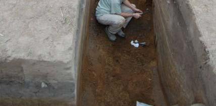
1 Geoarchaeology and Geophysics at Feltus Sarah C. Sherwood (Department of Anthropology, University of the South, Sewanee) Bryan S. Haley (Center for Archaeological Research, University of Mississippi) Jay K. Johnson (Center for Archaeological Research, University of Mississippi) [Paper presented at the Southeastern Archaeological Conference, Charlotte, N.C., 2008.] Part A: Geoarchaeology (by Sarah Sherwood) [Slide A-1] Archaeological stratigraphy provides the framework for our interpretation of artifacts, but whether making observations in the field or through the microscope it is also clear that the sediments themselves and their arrangement allow for inferences about human activity and site formation that artifacts do not [Slide A-2]. Work at Mound A at the Shiloh site in the Lower Tennessee River Valley brought a new dimension to this geoarchaeological approach [Slide A- 3]. It was here, working with David Anderson and John Cornelison, we realized that perhaps the mound layers were far more interesting than the pot sherds and animal bones how these layers were collected and laid down went far beyond simple basket loads of dirt. These data can inform us about the knowledge and skills that allow these earthworks to be both expressive monuments (in both their size and often color symbolism) and engineering marvels (were these structures were literally groomed and maintained to say nothing of the sheer fact that they are still here today) [Slide A-4]. Considering earthworks from this perspective allows us to explore important anthropological questions like the organization of labor, technology, periodicity of use, and religious practices. I visited Feltus shortly after the last SEAC at the kind invitation of Vin Steponaitis and John O Hear to see how we might be able to apply geoarchaeological analyses to their various research questions [Slide A-5]. At the time they probably hadn t factored in the rock hammer in relation to their immaculate profiles. Preliminary results are promising and an excellent opportunity to explore pre-mississippian mound construction. This type of geoarchaeological research is carried out across different scales which I will refer to as regional, site and micro. In order to begin to determine the construction decisions made, we have to first know what types of resources or building materials were available. Not all dirt is alike, and in other earthwork studies folks are clearly demonstrating that in some cases they were mixing different sources to a desired color or physical property. So with the brief time I have here I will take a look across the scales and focus on a few of the smaller questions posed to me when I was on site [Slide A-6]. I begin with the regional geology and soils and continue to the site scale or archaeological stratigraphy and then down to the micro-scale which here is limited to the micromorphological analysis of intact soils and sediments in thin section. Feltus is located in the Lower Mississippi Valley on the interior edge of the Brown Loam, Thick Loess [Slide A-7]. Loess can be a curse and blessing in mound building. It has very specific engineering properties when dry to damp this well sorted subangular medium silt can retain a steep or high angle of repose. But when saturated it essentially collapses. So to retain steep slopes on an earthen mound where loess is your primary local building material, we can assume an advanced 1
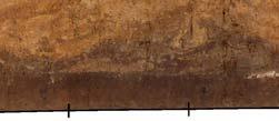
2 set of geotechnical skills to create deposits to avoid catastrophic failures. The local loess, deposited episodically during the late Pleistocene is predominantly composed of quartz with lesser amounts of carbonate (some deposited with the loess and some precipitated deep within the profiles), and limited feldspar and a few trace resistant minerals [Slide A-8]. The loess deposits generally weather into inceptisols on the slopes and alfisols on the upland surfaces. The inceptisols locally consist of the Natchez series, deep silt loams that are well drained but weakly developed and leached of carbonates. The more stable alfisols contain well developed Bt horizons of silty clay loam. Located a short walk off the bluff you are on the Mississippi river flood plain where additional mound building material can be easily acquired [Slide A-9]. These soils consist of fluvaquentic Inceptisols, Mollisols, Entisols, and Vertisols, nearly all composed of clay to silty clay, poorly drained and heavily gleyed. And my favorite taxonomic classification, a very-fine, smectitic, thermic, Chromic Epiaquert. We ll come back to these smectites shortly. The importance of careful observations and descriptions of the stratigraphy in the field at the site-scale cannot be under emphasized [Slide A-10]. In the lab you can run all the samples you want on high tech instrumentation but if you are unable to contextualize those samples your results are useless. We need to use standardized terms to record color, texture, structure and boundaries. The nature of a stratigraphic boundary can reveal important details about depositional history, especially in a mound. I will take a quick look at some interesting aspects of the Mound A stratigraphy observed in a long north-south trench extending obliquely along the eastern base of mound A [Slide A- 11]: first the base of the profile [Slide A-12] -- 3 samples at the base of the apron are described at the site and micro-scales. A natural soil profile is revealed with a buried A horizon grading into the top of an E horizon. The upper portions of the buried A are enriched with anthropogenic sediments, but not significantly. In thin section there is a slight increase in organic material and charcoal and a few sand size fragments of bone relative to the lower A horizon [Slide A-13]. The microstructure is slightly more porous due to increased bioturbation. The contact with the initial mound fill is abrupt. The only mixing there is due to large infilled insect burrows along the contact visible in the scans in the middle. The yellow fill appears to be loess parent material, with fragments of clay coatings suggesting it was derived from at least cm below the surface in the local subsoil. For comparison, the yellow box contains a photomicrograph of undisturbed Bt horizon material collected from outside of Feature 59 on the south end of the Plaza, approximately 130 cm below surface. You can see the secondary clay coating the voids, signatures of a strong Bt horizon. Also of interest in this profile and something that I find a constant challenge in dealing with 3-D stratigraphy in mounds and in caves in 2-D excavation -- is this area here [Slide A-14], where the trench has cross-cut a feature of something sloping toward you. This could be a flank extending from an earlier mound stage that was covered by the apron or perhaps the lower edge of an embankment as identified in many more recent mounds that were often covered by later stages. My final quick observation in Mound A deals with that of the "gumbo balls" [Slide A- 2
3 15]. These basketball-sized deposits intrigue everyone that sees them and in the next talk Garrett Cummings will look at potential ritual explanations. I will simply look at them for their physical characteristics. They are reportedly described in all three mounds explored in this project. I only got the chance to see them in Mound A. Shown here these appear in the field as heavily gleyed grey clay to silty clay with clear redoximorphic features in the form of oxidized concretions and concentrations. Interestingly when you dig into these they smelled strongly of sulfur or rotting organics. Here is a sample in thin section [Slide A-16]. Note both the dense clay matrix and the bright striations. These highly birefringent streaks indicate pressure and movement in the clays, fairly typical of smectites especially in vertisols. Smectite clays are common on the floodplain and I suspect that is what we are seeing here based on the evidence for pressure in thin section. Smectite is a 2:1 layer clay with shrink-swell properties. When wet they would be very sticky and highly plastic. What I don t see evidence for, however, is a source area underwater. Coming from the bottom of standing water such as a local slough I would expect these to be loaded with diatoms, unicellular algae with distinct silica bodies observed in thin section at high magnifications. Their absence suggests to me that these are derived from floodplain subsoils. Why this material is brought to the mound is open for discussion. In Mound B I sampled several portions of this trench cut into the western side of the mound [Slide A-17]. These profiles indicate a complex series of deposits with prepared floors, variable fills including probable sod block, etc. In an effort to identify primary vs. secondary deposits one of the questions the excavators wanted to address here was the nature of the midden material in these low areas. Were these redeposited by slope wash, representing activities that occurred higher on the stage surface or nearby or were they in situ? In thin section this material lacked any evidence of water deposition [Slide A-18]. Even when areas have been trampled or bioturbated after fluvial transport at the very least sand-size fragments of graded bedding remain. Mixed charcoal, organic matter and various sizes and types of bone fragments suggest that these deposits are in their original context. In addition the absence of root disturbance suggests it was relatively quickly buried by additional mound construction. In sum, there is tremendous potential for geoarchaeological analyses to illuminate details about this early mound complex [Slide A-19]. And if you are looking for an exciting dissertation topic I have just the one. 3


4 Geoarchaeology and Geophysics at Feltus Sarah C. Sherwood (University of the South) Bryan S. Haley (University of Mississippi) Jay K. Johnson (University of Mississippi) Geoarchaeology at Feltus 4


5 Shiloh Mound A (NPS) H G F E A D B C Shiloh Mound A (NPS) 5


6 x 6


7 Slope Failure Local Soil Series 7


8 F l o o d p l a i n U p l a n d s Geoarchaeological Sampling in the South Plaza 8


9 Mound A Excavations A Feltus Mound A B 9


10 Thin section scan Photomicrographs Upland Subsoil PPL XPL 5 cm 10


11 Sample F11 11


12 B A Feltus Mound B 12
13 13
Geoarchaeology and Geophysics at Feltus
 Geoarchaeology and Geophysics at Feltus Sarah C. Sherwood (Department of Anthropology, University of the South, Sewanee) Bryan S. Haley (Center for Archaeological Research, University of Mississippi) Jay
Lecture 7: Introduction to Soil Formation and Classification
 Lecture 7: Introduction to Soil Formation and Classification Soil Texture and Color Analysis Lab Results Soil A: Topsoil from Prof. Catalano s backyard Soil B: Soil above beach at Castlewood State Park
Lab Exercise 3: Geology, Soils and Archaeological Site Settings of Rift Valleys
 Name: Lab Exercise 3: Geology, Soils and Archaeological Site Settings of Rift Valleys Objectives: Grading The objectives of this lab are to: 1. To reinforce through exercises the sedimentary and stratigraphic
Physical Geology, 15/e
 Lecture Outlines Physical Geology, 15/e Plummer, Carlson & Hammersley Weathering and Soil Physical Geology 15/e, Chapter 5 Weathering, Erosion and Transportation Rocks exposed at Earth s surface are constantly
Weathering, Erosion and Deposition
 Weathering, Erosion and Deposition Shaping the Earth s Surface Weathering the process of breaking down rocks into smaller fragments Erosion the transport of rock fragments from one location to another
Gumbo Balls and Earth Divers: Contagious Magic in Mound Construction at a Coles Creek Site. Garrett B. Cummings (UNC-Chapel Hill)
") Gumbo Balls and Earth Divers: Contagious Magic in Mound Construction at a Coles Creek Site Garrett B. Cummings (UNC-Chapel Hill) [Paper presented at the Southeastern Archaeological Conference, Charlotte,
Gumbo Balls and Earth Divers: Contagious Magic in Mound Construction at a Coles Creek Site Garrett B. Cummings (UNC-Chapel Hill) [Paper presented at the Southeastern Archaeological Conference, Charlotte,
Monday, October 15 th Grab a textbook! Objective: We will explain the formation of different soils and classify soils according to particle size.
 Soil Mr. Gilmore Monday, October 15 th Grab a textbook! Objective: We will explain the formation of different soils and classify soils according to particle size. Review: 1. The four limestone samples
APPENDIX G GLOSSARY. Mn/DOT/WR-0200
 APPENDIX G GLOSSARY Mn/DOT/WR-0200 Alluvial - comprised of clay, silt, sand, gravel, and/or other detritus deposited by water. Usually refers to accretionary overbank, floodplain or levee deposits. Biomantling
Soil Mechanics/Geotechnical Engineering I Prof. Dilip Kumar Baidya Department of Civil Engineering Indian Institute of Technology, Kharagpur
 Soil Mechanics/Geotechnical Engineering I Prof. Dilip Kumar Baidya Department of Civil Engineering Indian Institute of Technology, Kharagpur Lecture - 01 Rock Cycle Good morning. I welcome you to this
Soil Mechanics. Chapter # 1. Prepared By Mr. Ashok Kumar Lecturer in Civil Engineering Gpes Meham Rohtak INTRODUCTION TO SOIL MECHANICS AND ITS TYPES
 Soil Mechanics Chapter # 1 INTRODUCTION TO SOIL MECHANICS AND ITS TYPES Prepared By Mr. Ashok Kumar Lecturer in Civil Engineering Gpes Meham Rohtak Chapter Outlines Introduction to Soil Mechanics, Soil
Case study 22: Soil and Sediment Analysis from Viking to Medieval deposits in Orkney
 Case study 22: Soil and Sediment Analysis from Viking to Medieval deposits in Orkney Ian A. Simpson, James H. Barrett and Karen B. Milek This case study is based on Simpson, I.A. J.H. Barrett and K.B.
Introduction to Soil Science and Wetlands Kids at Wilderness Camp
 Introduction to Soil Science and Wetlands Kids at Wilderness Camp Presented by: Mr. Brian Oram, PG, PASEO B.F. Environmental Consultants http://www.bfenvironmental.com and Keystone Clean Water Team http://www.pacleanwater.org
Weathering, Soil, and Mass Movements
 Tarbuck Lutgens Weathering, Soil, and Mass Movements 5.1 Weathering Mechanical Weathering Mechanical weathering occurs when physical forces break rock into smaller and smaller pieces without changing the
Weathering, Erosion, Deposition, and Landscape Development
 Weathering, Erosion, Deposition, and Landscape Development I. Weathering - the breakdown of rocks into smaller particles, also called sediments, by natural processes. Weathering is further divided into
SUPPLEMENTAL MATERIAL
 SUPPLEMENTAL MATERIAL DESCRIPTIONS OF OTHER STRATIGRAPHIC SECTIONS Cherry Creek In its middle reaches, Cherry Creek meanders between three paired terraces within a narrow bedrock valley. The highest is
Monday, Oct Field trip A1 & A2 signups: make sure you are where you think you should be
 Monday, Oct. 4 1. Field trip A1 & A2 signups: make sure you are where you think you should be 2. 5 credit people, field trip introduction in lab today 1. If you are unable to attend THIS SATURDAY, let
GY 111 Lecture Note Series Sedimentary Environments 2: Rivers and Deltas
 GY 111 Lecture Notes D. Haywick (2008-09) 1 GY 111 Lecture Note Series Sedimentary Environments 2: Rivers and Deltas Lecture Goals A) Rivers and Deltas (types) B) Water Flow and sedimentation in river/deltas
STUDENT SOIL PRESENTATIONS
 STUDENT SOIL PRESENTATIONS Soil Order (and informal name) Student Name(s) Alfisol = deciduous forest soil Andisol = formed on volcanic ash Aridisol = desert soil Entisol = alluvium soil Gelisol = tundra
Sediment and sedimentary rocks Sediment
 Sediment and sedimentary rocks Sediment From sediments to sedimentary rocks (transportation, deposition, preservation and lithification) Types of sedimentary rocks (clastic, chemical and organic) Sedimentary
Mechanical Weathering
 Mechanical Weathering Objectives Students will be able to: Explain how weathering breaks down rock. Explain how a rock s surface area affects the rate of weathering. The Great Sphinx Of all the amazing
Mechanical Weathering
 Weathering is the disintegration and decomposition of material at or near the surface. Erosion is the incorporation and transportation of material by a mobile agent, usually water, wind, or ice. Geologists
Clyde River Landslide
 Clyde River Landslide Department of Geology, Perkins Hall, University of Vermont, Burlington, VT 05405 Abstract: This paper investigates a landslide on the Clyde River in Newport, Vermont. The landslide
Geology 252, Historical Geology, California State University, Los Angeles - professor: Dr. Alessandro Grippo
 LAB # 1 - CLASTIC ROCKS Background: - Mechanical and Chemical Weathering - Production of Clastic Sediment - Classification of Sediment according to size: Gravel, Sand, Silt, Clay - Erosion, Transportation
Mass Wasting. Requirements for Mass Wasting. Slope Stability. Geol 104: mass wasting
 Mass Wasting Movement of earth materials downslope, driven by Gravitational Forces. Landslides - general term for rock or soil movement. In U.S., on average, mass wasting causes 1 to 2 billion dollars
Prehistoric Clay Sources: A Forensic Exercise in Geoarchaeology
 Prehistoric Clay Sources: A Forensic Exercise in Geoarchaeology Lynn Ketterhagen Faculty Sponsor: Dean Wilder, Department of Geography and Earth Science ABSTRACT The prehistoric Oneota culture of the Upper
Soil Profiles (West, Ch. 8)
") Geology 229 Engineering Geology Lecture 24 Soil Profiles (West, Ch. 8) We have just finished the discussion of rock weathering. One direct consequence of weathering is the formation of the soil profile.
Geology 229 Engineering Geology Lecture 24 Soil Profiles (West, Ch. 8) We have just finished the discussion of rock weathering. One direct consequence of weathering is the formation of the soil profile.
Monitoring and modelling hydrological fluxes in support of nutrient cycling studies in Amazonian rain forest ecosystems Tobon-Marin, C.
 UvA-DARE (Digital Academic Repository) Monitoring and modelling hydrological fluxes in support of nutrient cycling studies in Amazonian rain forest ecosystems Tobon-Marin, C. Link to publication Citation
Collfryn Ring-ditch, Guilsfield, Powys
 CPAT Report No 1122 TRIAL EXCAVATION 2011 THE CLWYD-POWYS ARCHAEOLOGICAL TRUST CPAT Report No 1122 TRIAL EXCAVATION 2011 I Grant December 2011 Report for Cadw The Clwyd-Powys Archaeological Trust 41 Broad
Chapter 10. Chapter Rocks and the Rock Cycle. Rocks. Section 1 Rocks and the Rock Cycle
 Chapter 10 Rocks 1 Chapter 10 Section 1 Rocks and the Rock Cycle 2 10.1 Rocks and the Rock Cycle Magma is the parent material for all rocks. Once the magma cools and hardens, many changes can occur. Geology:
Sedimentary Features in Expedition 341 Cores: A Guide to Visual Core Description
 Sedimentary Features in Expedition 341 Cores: A Guide to Visual Core Description 1. Typical Deep water Sediments in the Gulf of Alaska 1A & B: Mud and 1C: Laminated mud Description: Mud is representative
Earth Science, 10e. Edward J. Tarbuck & Frederick K. Lutgens
 Earth Science, 10e Edward J. Tarbuck & Frederick K. Lutgens Weathering, Soil, and Mass Wasting Chapter 3 Earth Science, 10e Stan Hatfield and Ken Pinzke Southwestern Illinois College Earth's external processes
Table of Contents Chapter 1 Introduction to Geotechnical Engineering 1.1 Geotechnical Engineering 1.2 The Unique Nature of Soil and Rock Materials
 Table of Contents Chapter 1 Introduction to Geotechnical Engineering 1.1 Geotechnical Engineering 1.2 The Unique Nature of Soil and Rock Materials 1.3 Scope of This Book 1.4 Historical Development of Geotechnical
Quick Clay: (Leda Clay gone bad!) Origin, Mineralogy, Chemistry and Landslides
 Origin, Mineralogy, Chemistry and Landslides") Quick Clay: (Leda Clay gone bad!) Origin, Mineralogy, Chemistry and Landslides What is Leda Clay? The fine-grained (silty clay and clayey silt) sediments that accumulated in the St. Lawrence drainage basin,
Quick Clay: (Leda Clay gone bad!) Origin, Mineralogy, Chemistry and Landslides What is Leda Clay? The fine-grained (silty clay and clayey silt) sediments that accumulated in the St. Lawrence drainage basin,
 UNIT DESCRIPTIONS: Artificial Fill, Undocumented (Afu): Locally derived sandy silt and silty sand, locally with clay and varying amounts of gravel and man-made debris. Abundant concrete rubble, in places
Unit 3 Study Guide -- Greenberg science, 6C
 Unit 3 Study Guide -- Greenberg science, 6C Name Pd. Date / / 2018 + +5 extra credit points on the test if submitted complete and correct ON THE TEST DATE. + A copy can be found on my website mgreenberg.weebly.com
EARTH S CHANGING SURFACE
 EARTH S CHANGING SURFACE Weathering Together, weathering and erosion work continuously to wear down the material on Earth s surface. weathering process that breaks down rock and other substances of Earth
J. Paul Guyer, P.E., R.A.
 J. Paul Guyer, P.E., R.A. Paul Guyer is a registered mechanical engineer, civil engineer, fire protection engineer and architect with over 35 years experience in the design of buildings and related infrastructure.
Geo 302D: Age of Dinosaurs. LAB 2: Sedimentary rocks and processes
 Geo 302D: Age of Dinosaurs LAB 2: Sedimentary rocks and processes Last week we covered the basic types of rocks and the rock cycle. This lab concentrates on sedimentary rocks. Sedimentary rocks have special
Evaluation/Monitoring Report No. 259
 SITE 100M EAST OF 16 LEARMORE ROAD CASTLEGORE CASTLEDERG COUNTY TYRONE LICENCE NO.: AE/13/36E NAOMI CARVER 1 Site Specific Information Site Name: 100m east of 16 Learmore Road, Castlederg, Co. Tyrone Townland:
Environmental Science Institute The University of Texas - Austin
 Environmental Science Institute The University of Texas - Austin Geologic Wonders of Central Texas Dr. Leon Long This file contains suggestions for how to incorporate the material from this CDROM into
Collapsible Soils Definitions
 Collapsible Soils Definitions Collapsible soils are also known as metastable soils. They are unsaturated soils that undergo a large volume change upon saturation. The sudden and usually large volume change
Chemical Weathering and Soils
 Chemical Weathering and Soils Fresh rocks and minerals that once occupied the outermost position reached their present condition of decay through a complex of interacting physical, chemical, and biological
Feet. Cape May Core #51 Start depth: 240 ft Stop depth: 245 ft Recovery (ft): 5.1 ft Date: 3/21/94 Described by: JVB, KGM, CL. 5.
: 5.1 ft Date: 3/21/94 Described by: JVB, KGM, CL. 5.") SAND; medium to fine sand with abundant silt, homogenous slightly mottled appearance; mica on outside, mostly quartz; few darks; peat layer.9 - ft; cnv - same as above; the last few cores are all the same;
SAND; medium to fine sand with abundant silt, homogenous slightly mottled appearance; mica on outside, mostly quartz; few darks; peat layer.9 - ft; cnv - same as above; the last few cores are all the same;
Sedimentary Geology. Strat and Sed, Ch. 1 1
 Sedimentary Geology Strat and Sed, Ch. 1 1 Sedimentology vs. Stratigraphy Sedimentology is the study of the origin and classification of sediments and sedimentary rocks Mostly the physical and chemical
GG 454 January 18, SOILS (06)
") GG 454 January 18, 2002 1 SOILS (06) I Main Topics A Pedologic classification schemes B Engineering classification schemes C Behavior of soils and influence of geologic history II Pedologic classification
GG 454 January 18, 2002 1 SOILS (06) I Main Topics A Pedologic classification schemes B Engineering classification schemes C Behavior of soils and influence of geologic history II Pedologic classification
PHYSICAL GEOGRAPHY. By Brett Lucas
 PHYSICAL GEOGRAPHY By Brett Lucas SOILS Soils Soil and Regolith Soil-Forming Factors Soil Components Soil Properties Soil Chemistry Soil Profiles Pedogenic Regimes Global Distribution of Soils Distribution
Lowest and Youngest Terrace : Soil Pit #4
 Lowest and Youngest Terrace : Soil Pit #4 Observations : Where : Huntington Terraces Climate : Cloudy, mid 60 s Our soil pit was the lowest of the 4 sites The pit site was located on the right side of
EARTH SCIENCE KESSEL
 EARTH SCIENCE KESSEL Bell Ringer Explain the concept of matter.? s to answer that might help you in your explanation: 1. What is it? 2. What is it made of? 3. Does it have a shape? 4. How would you know
Clay Robinson, PhD, CPSS, PG copyright 2009
 Engineering: What's soil got to do with it? Clay Robinson, PhD, CPSS, PG crobinson@wtamu.edu, http://www.wtamu.edu/~crobinson, copyright 2009 Merriam-Webster Online Dictionary soil, noun 1 : firm land
Circle the correct (best) terms inside the brackets:
 terms inside the brackets:") 1 Circle the correct (best) terms inside the brackets: 1) Soils are [consolidated / unconsolidated] [natural / artificial] bodies at the earth s surface. Soils contain mineral and organic material, which
1 Circle the correct (best) terms inside the brackets: 1) Soils are [consolidated / unconsolidated] [natural / artificial] bodies at the earth s surface. Soils contain mineral and organic material, which
Correlation of gravel deposits from trenching project on Alder Creek fluvial terrace near Point Arena, California
 Correlation of gravel deposits from trenching project on Alder Creek fluvial terrace near Point Arena, California Aletha Lee Department of Geology and Geography, West Virginia University, White Hall, Morgantown,
Waterbury Dam Disturbance Mike Fitzgerald Devin Rowland
 Waterbury Dam Disturbance Mike Fitzgerald Devin Rowland Abstract The Waterbury Dam was completed in October 1938 as a method of flood control in the Winooski Valley. The construction began in April1935
Objectives. Introduction to Soils. Terms to know: What is soil? Study of Soils. The Soil Body 11/9/2012
 Objectives Explain what soil is and where it comes from Define a soil body List examples of the five soil-forming factors Explain how soils develop Introduction to Soils Terms to know: What is soil? Alluvial
Bell Ringer. Are soil and dirt the same material? In your explanation be sure to talk about plants.
 Bell Ringer Are soil and dirt the same material? In your explanation be sure to talk about plants. 5.3 Mass Movements Triggers of Mass Movements The transfer of rock and soil downslope due to gravity is
Rocks and Weathering
 Rocks and Weathering The Effects of Weathering The process of mountain building thrusts rock up to Earth s surface. Weathering is the process that breaks down rock and other substances at Earth s surface.
Geology 229 Engineering Geology. Lecture 6. Basic Rock Classification and Engineering Considerations (West, Chs. 2, 3, 4, 5)
") Geology 229 Engineering Geology Lecture 6 Basic Rock Classification and Engineering Considerations (West, Chs. 2, 3, 4, 5) Outline of this Lecture 1. Rock types and rock cycle 2. Geological and engineering
Geology 229 Engineering Geology Lecture 6 Basic Rock Classification and Engineering Considerations (West, Chs. 2, 3, 4, 5) Outline of this Lecture 1. Rock types and rock cycle 2. Geological and engineering
ESC102. Sedimentary Rocks. Our keys to the past. Monday, February 11, 13
 ESC102 Sedimentary Rocks Our keys to the past Sedimentary Rocks Sedimentary rocks are rocks that form through the accumulation of sediment and the process of lithification. Lithification occurs after deposition
EPS 50 Lab 4: Sedimentary Rocks
 Name: EPS 50 Lab 4: Sedimentary Rocks Grotzinger and Jordan, Chapter 5 Introduction In this lab we will classify sedimentary rocks and investigate the relationship between environmental conditions and
MINNESOTA DEEP TEST PROTOCOL PROJECT
 MINNESOTA DEEP TEST PROTOCOL PROJECT Mn/DOT Agreement No. 85878 OSA License No. 04-030 Authorized and Sponsored by: MINNESOTA DEPARTMENT OF TRANSPORTATION FEDERAL HIGHWAY ADMINISTRATION Prepared by COMMONWEALTH
Weathering and Soil Formation. Chapter 10
 Weathering and Soil Formation Chapter 10 Old and New Mountains The Appalachian Mountains appear very different from the Sierra Mountains. The Appalachians are smaller, rounded, gently sloping, and covered
Studying Rocks and Soil
 Studying Rocks and Soil How do rocks form? Rocks Rock is found in nature. Rock is solid. It is nonliving matter. All rocks are made of one or more minerals. A mineral is a natural material that forms from
Engineering Geology ECIV 3302
 Engineering Geology ECIV 3302 Instructor : Dr. Jehad Hamad 2019-2018 Chapter (5) Weathering & Soil Chapter 5: Weathering, Soil, and Mass Wasting External processes include : (1) Weathering (2) Mass wasting
What factors affect the angle of a slope?
 Climate Rock type and Structure What factors affect the angle of a slope? Aspect Fast mass movements Slides: Slides are movements along the SLIP PLANE, i.e. a line of weakness in the rock or soil structure.
Topic 6: Weathering, Erosion and Erosional-Deposition Systems (workbook p ) Workbook Chapter 4, 5 WEATHERING
 Workbook Chapter 4, 5 WEATHERING") Topic 6: Weathering, Erosion and Erosional-Deposition Systems (workbook p. 95-125) Workbook Chapter 4, 5 THE BIG PICTURE: Weathering, erosion and deposition are processes that cause changes to rock material
Topic 6: Weathering, Erosion and Erosional-Deposition Systems (workbook p. 95-125) Workbook Chapter 4, 5 THE BIG PICTURE: Weathering, erosion and deposition are processes that cause changes to rock material
5. Which surface soil type has the slowest permeability rate and is most likely to produce flooding? A) pebbles B) sand C) silt D) clay A) B) C) D)
 pebbles B) sand C) silt D) clay A) B) C) D)") 1. During a heavy rainstorm, soil samples A and B both became saturated with water. However, 10 minutes after the storm ended, the soils appeared as shown below. Which statement best explains the observed
1. During a heavy rainstorm, soil samples A and B both became saturated with water. However, 10 minutes after the storm ended, the soils appeared as shown below. Which statement best explains the observed
Soil Surveys. What are the most important properties to consider in a taxonomic system used for making a soil survey?
 Soil Surveys What are the most important properties to consider in a taxonomic system used for making a soil survey? What is a Soil Survey? Inventory of soil resources Delineation of spatial distribution
Ocean Floor. Continental Margins. Divided into 3 major regions. Continental Margins. Ocean Basins. Mid-Ocean Ridges. Include:
 Ocean Floor Divided into 3 major regions Continental Margins Ocean Basins Mid-Ocean Ridges Continental Margins Include: Continental Shelves Continental Slopes Continental Rise 1 Continental Shelves Part
Soil Formation. Lesson Plan: NRES B2-4
 Soil Formation Lesson Plan: NRES B2-4 1 Anticipated Problems 1. What are five different factors that affect soil formation? 2. What are some different types of parent material that affect soils? 3. What
Introduction to Archaeology: Notes 6 Stratigraphy and site formation Copyright Bruce Owen 2009 The most basic question about an archaeological site
 Introduction to Archaeology: Notes 6 Stratigraphy and site formation Copyright Bruce Owen 2009 The most basic question about an archaeological site why is this stuff here, and arranged the way it is? why
Sedimentary Rocks. Origin, Properties and Identification. Physical Geology GEOL 101 Lab Ray Rector - Instructor
 Sedimentary Rocks Origin, Properties and Identification Physical Geology GEOL 101 Lab Ray Rector - Instructor Sedimentary Rock Origin and Identification Lab Pre-Lab Internet Link Resources 1) http://www.rockhounds.com/rockshop/rockkey/index.html
Overview. Rock weathering Functions of soil Soil forming factors Soil properties
 UN-FAO A. Healthy soils are the basis for healthy food production. B. A tablespoon of normal topsoil has more microorganisms than the entire human population on Earth. C. It can take up to 1,000 years
Archaeology and Geophysics at the Chillicothe Site, Ohio, USA
 info@gemsys.on.ca Archaeology and Geophysics at the Chillicothe Site, Ohio, USA In this short paper, we summarize the recent procedings of the National Parks Service Archaeology Workshop in Chillicothe,
Table 9. FAI accession log
 Table 9. FAI-02045 accession log UA Accession # FS # Depth (cm BS) Artifact Type n= Material Color UA2010-187-0001 1 5-10 utilized flake 1 basalt black UA2010-187-0002 2 5-10 flake 1 chert black UA2010-187-0003
Although not essential, a good quality hand lens is a valuable addition to your field kit.
 Field Sediment Card Sediment characteristics are an important element in understanding marine and estuarine environments.there are thus a wide range of people (perhaps you!) who regularly use measurements
Weathering The effects of the physical and chemical environment on the decomposition of rocks
 Weathering The effects of the physical and chemical environment on the decomposition of rocks - Igneous rocks form at high temperatures and the constituent minerals reflect the conditions of formation.
A. IGNEOUS Rocks formed by cooling and hardening of hot molten rock called magma (within crust or at its surface).
.") EARTH SCIENCE 11 CHAPTER 5 NOTES KEY How Earth's Rocks Were Formed Early geologists believed that the physical features of the Earth were formed by sudden spectacular events called CATASTROPHES. Modern
EARTH SCIENCE 11 CHAPTER 5 NOTES KEY How Earth's Rocks Were Formed Early geologists believed that the physical features of the Earth were formed by sudden spectacular events called CATASTROPHES. Modern
Unit E: Basic Principles of Soil Science. Lesson 2: Understanding Soil Formation
 Unit E: Basic Principles of Soil Science Lesson 2: Understanding Soil Formation Important Terms Alluvium Bedrock Chemical weathering Climate Glacial till Loess Native vegetation Organic matter Outwash
New York University Excavations at Amheida 2010 Geological Investigations LOCAL GEOLOGY
 New York University Excavations at Amheida 2010 Geological Investigations LOCAL GEOLOGY The geology of the Amheida area has been outlined previously by the site topographers; the general geomorphology
Weathering is the process that breaks down rock and other substances at Earth s surface
 Chapter 8 Notes Weathering is the process that breaks down rock and other substances at Earth s surface Factors that contribute to weathering Heat Cold Water Ice O 2 & CO 2 in the atmosphere Examples of
Essential Questions. What is erosion? What is mass wasting?
 Erosion Essential Questions What is erosion? What is mass wasting? What is Erosion? Erosion The transportation of sediment from one area to another Caused mainly by running water but also caused by glaciers,
A. V T = 1 B. Ms = 1 C. Vs = 1 D. Vv = 1
 Geology and Soil Mechanics 55401 /1A (2002-2003) Mark the best answer on the multiple choice answer sheet. 1. Soil mechanics is the application of hydraulics, geology and mechanics to problems relating
Geology and Soil Mechanics /1A ( ) Mark the best answer on the multiple choice answer sheet.
 Mark the best answer on the multiple choice answer sheet.") Geology and Soil Mechanics 55401 /1A (2003-2004) Mark the best answer on the multiple choice answer sheet. 1. Soil mechanics is the application of hydraulics, geology and mechanics to problems relating
Geology and Soil Mechanics 55401 /1A (2003-2004) Mark the best answer on the multiple choice answer sheet. 1. Soil mechanics is the application of hydraulics, geology and mechanics to problems relating
Chapter 6 Geoarchaeological Investigation of New Philadelphia: Soil Core Testing of Thermal Infrared Anomalies 1
 Chapter 6 Geoarchaeological Investigation of New Philadelphia: Soil Core Testing of Thermal Infrared Anomalies 1 M. Kathryn Rocheford 2 Background The New Philadelphia town site was designated as a National
Earth and Space Science. Semester 2 Review, Part 2
 Earth and Space Science Semester 2 Review, Part 2 2015 Chemical Weathering -The process that breaks down rock through chemical changes. Examples that cause chemical weathering include the action of water
Surface Processes on the Earth. Rocks, Weathering, Erosion and Soil
 Surface Processes on the Earth Rocks, Weathering, Erosion and Soil ROCKS AND ROCK CYCLE Rock types Three main types of rock Igneous Metamorphic Sedimentary Igneous Form when magma or lava cools and hardens
Sedimentary Rocks. Origin, Properties and Identification. Geology Laboratory GEOL 101 Lab Ray Rector - Instructor
 Sedimentary Rocks Origin, Properties and Identification Geology Laboratory GEOL 101 Lab Ray Rector - Instructor Sedimentary Rock Origin and Identification Lab Pre-Lab Internet Link Resources 1) http://www.rockhounds.com/rockshop/rockkey/index.html
MOR SEAWAY TEACHERS. A CHANGING LANDSCAPE Activity Overview BIG IDEA
 MOR SEAWAY 03 Activity Overview BIG IDEA The Earth and its landscapes change over time. Scientists use the fossil record to understand the Earth s environments and climates millions of years ago. OBJECTIVE
GEOL Lab #11 Information (Guidelines for Student Soil Presentations on April 8)
") GEOL 333 - Lab #11 Information (Guidelines for Student Soil Presentations on April 8) Assignment During Lab on April 8, you will give an oral presentation about one of the 12 soil orders (categories).
GEOL 333 - Lab #11 Information (Guidelines for Student Soil Presentations on April 8) Assignment During Lab on April 8, you will give an oral presentation about one of the 12 soil orders (categories).
Chapter 10 - Geology. Earth s Structure, Geologic Hazards, and Soils
 Chapter 10 - Geology Earth s Structure, Geologic Hazards, and Soils Plate Tectonics Earth crust (or lithosphere) is broken up into plates that shift and slide around Asthenosphere (semi molten layer of
Soil Formation. Parent Material. Time. Climate
 Soil Formation Parent Material Time Climate Topography Biota Main Objectives 1. Gain a general understanding of soil formation processes 2. Understand the importance of mineral weathering in soil formation
Sedimentary Rocks. Origin, Properties and Identification. Physical Geology GEOL 100. Ray Rector - Instructor
 Sedimentary Rocks Origin, Properties and Identification Physical Geology GEOL 100 Ray Rector - Instructor Sedimentary Rock Origin and Identification Lab Pre-Lab Internet Link Resources 1) http://www.rockhounds.com/rockshop/rockkey/index.html
Focus on Fossils. Third - Fifth. Earth Science TEKS. Vocabulary
 Focus on Fossils Third - Fifth Earth Science TEKS Third Grade: 3.7A Fourth Grade: 4.7B Fifth Grade: 5.7A, 5.7D Vocabulary decomposition, deposition, erosion, extinct, fossil, paleontologist, relative dating,
Your teacher will show you a sample or diagram of each, and show you a settling column. Draw these, and label your diagrams (8 pts) Ungraded:
 Ungraded:") From Sand to Stone: How do we recognize and interpret sedimentary rocks in the rock record? (Based closely on the University of Washington ESS 101 Lab 5: Sedimentary Rocks) Introduction: This lab consists
From Sand to Stone: How do we recognize and interpret sedimentary rocks in the rock record? (Based closely on the University of Washington ESS 101 Lab 5: Sedimentary Rocks) Introduction: This lab consists
Geotechnical Properties of Soil
 Geotechnical Properties of Soil 1 Soil Texture Particle size, shape and size distribution Coarse-textured (Gravel, Sand) Fine-textured (Silt, Clay) Visibility by the naked eye (0.05 mm is the approximate
Geo 302D: Age of Dinosaurs. LAB 1: Introduction to Rocks and Sedimentary Processes
 Geo 302D: Age of Dinosaurs LAB 1: Introduction to Rocks and Sedimentary Processes We would not be able to address the interesting questions of dinosaurs and their place in the history of life without the
RALPH SIMMONS STATE FOREST 2016 LAND MANAGEMENT PLAN EXHIBITS
 RALPH SIMMONS STATE FOREST 2016 LAND MANAGEMENT PLAN EXHIBITS EXHIBIT A Location Map Exhibit A EXHIBIT B Management Accomplishment Summary for RSSF EXHIBIT C Proximity to Other Public Lands Exhibit C
Ecoregions Glossary. 7.8B: Changes To Texas Land Earth and Space
 Ecoregions Glossary Ecoregions The term ecoregions was developed by combining the terms ecology and region. Ecology is the study of the interrelationship of organisms and their environments. The term,
Stratigraphy and structure of the Ganson Hill area: northern Taconic Allochthon
 University at Albany, State University of New York Scholars Archive Geology Theses and Dissertations Atmospheric and Environmental Sciences 1985 Stratigraphy and structure of the Ganson Hill area: northern
The physical breakdown and chemical alteration of rocks and minerals at or near Earth s surface.
 The physical breakdown and chemical alteration of rocks and minerals at or near Earth s surface. The material that is chemically and mechanically weathered to yield sediment and soil. Regolith consisting
Geology and New England Landscapes
 Geology and New England Landscapes Jim Turenne, CPSS USDA-NRCS Warwick, RI. http://nesoil.com Why Geology? Provides the big picture of site conditions. Major part of soil formation (parent material and