Hydraulic Geometry Relationships for Rural North Carolina Coastal Plain Streams
|
|
|
- Maximillian Flynn
- 6 years ago
- Views:
Transcription
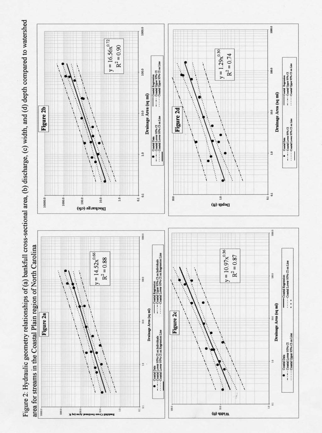
1 Hydraulic Geometry Relationships for Rural North Carolina Coastal Plain Streams Barbara A. Doll 1, Angela D. Dobbins 2, Jean Spooner 3, Daniel R. Clinton 4, David A. Bidelspach 4 ABSTRACT: Hydraulic geometry relationships, or regional curves, relate bankfull stream channel dimensions to watershed drainage area. Hydraulic geometry relationships for streams throughout North Carolina vary with hydrology, soils, and extent of development within a watershed. This coastal curve shows the bankfull features of streams in the rural areas throughout the North Carolina Coastal Plain. Sixteen streams were surveyed in watersheds that had less than ten-percent impervious cover. Any disturbance to the stream channels had occurred long enough ago for the streams to redevelop bankfull features and had no major impoundments. The drainage areas for the streams ranged from 0.2 to 161 square miles. Cross-sectional and longitudinal surveys were conducted to determine the channel dimension, pattern and profile of each stream and power functions were fitted to the data. NC State University and the Natural Resource Conservation Service collected the study data. Regional curves are useful tools for applying natural channel design. They do not, however, replace the need for field calibration and verification of bankfull stream channel dimensions. KEY TERMS: Hydraulic Geometry, Regional Curve, Bankfull, Flood Frequency Analyses INTRODUCTION Decades of ditching, draining, farming and development have degraded large numbers of streams throughout the coastal area of North Carolina. Watershed hydromodification, channelization, loss of riparian vegetation, floodplain restrictions and changes in hydrology have altered the dimension, pattern, and profile, and thereby the function, and habitat of many coastal streams. Restoration of streams is a priority focus for many federal, state and local government agencies and nonprofit groups. Many restoration practitioners 1 Water Quality Specialist, NC Sea Grant, Box 8605, NC State University, Raleigh NC 27695, (919) , fax: (919) , barbara_doll@ncsu.edu 2 Assistant County Ranger, N.C. Forest Service, 5344 Bass Mountain Rd., Snow Camp NC 27349, (336) Associate Professor, NC State University, Department of Biological and Agricultural Engineering, Water Quality Group, Campus Box 7637, Raleigh NC 27695, (919) Research Associate, Extension Associate, NC State University Department of Biological and Agricultural Engineering, Campus Box 7637, Raleigh NC 27695, (919)
2 strive to restore stability to disturbed streams by rebuilding natural stream characteristics, including a properly sized bankfull channel, adequate floodplain width, meanders, riffles and pools. Stability is achieved when the stream has developed a stable dimension, pattern and profile such that, over time, channel features are maintained and the stream system neither aggrades nor degrades (Rosgen, 1996). This restoration approach relies on the accurate identification of the bankfull channel dimension and discharge. Hydraulic geometry relationships that relate bankfull stream channel dimensions and discharge to watershed drainage area are therefore useful tools for stream restoration design. Dunne and Leopold (1978) first developed hydraulic geometry relationships for the bankfull stage, also called regional curves. Hydraulic geometry relationships for streams vary with hydrology, soils, and extent of development within a watershed; therefore, it is necessary to develop curves for various levels of development in each hydrophysiographic region. There are three primary physiographic regions in North Carolina including the Mountains, Piedmont, and Coastal Plain. The Coastal Plain is characterized by flat land to gently rolling hills and valleys. Elevations range from sea level near the coast to about 600 feet in the Sand Hills of the southern inner Coastal Plain. The Coastal Plain is the largest geologic belt in the state covering 45 percent of the land area and consisting of a wedge of mostly marine sedimentary rocks that gradually thickens to the east. The most common sediment types are sand and clay, although a significant amount of limestone occurs in the southern part of the Coastal Plain. Rainfall is highly variable in the Coastal Plain, averaging between 45 and 60 inches per year depending on location. Hydraulic geometry data have already been developed for rural (Harman et al., 1999) and urban (Doll et al, 2002) Piedmont North Carolina streams and for the Mountains (Harman et al., 2000). This study focuses on identifying bankfull dimension and discharge of rural streams in the Coastal Plain region. Sixteen streams were surveyed in North Carolina Coastal Plain with watersheds that had less than ten-percent impervious cover, including seven USGS gaged streams and nine reference quality stream reaches. Despite any past disturbance, modifications to the streams included in the study had occurred long enough ago for the streams to redevelop bankfull features and had no major impoundments. The USGS gaged streams included in the study were in the process of recovering from past disturbances, primarily 2

3 channelization. The reaches selected for survey were, however, stable. The reference reach channels selected appeared to have experienced much less modification if any compared to the USGS gaged streams. These reaches were very stable meandering streams with high quality habitat features, including properly located riffles and pools and large woody debris. The drainage areas for the streams ranged from 0.2 to 161 square miles. The study includes data collected by NC State University, and by the Natural Resource Conservation Service. The locations of the survey sites are displayed on the map in Figure 1. Figure 1. Survey Sites in North Carolina MATERIALS AND METHODS U.S. Geological Survey (USGS) gaged Coastal Plain streams were identified. Of the gaged streams, only those that met the study criteria were surveyed. The study site criteria included: Coastal Plain streams with less than ten-percent impervious surface in their drainage area (Schueler, 1995), no major impoundments, exhibiting bankfull indicators and having a stable riffle or run cross-section. In addition, 3
4 reference quality streams were identified through map analysis, local agency contacts and field reconnaissance. A reference reach is a stable river segment that represents a stable channel within a particular valley morphology (Rosgen, 1998). The reference streams were not necessarily pristine, however, they were in stable watersheds; did not exhibit any signs of incision or head-cutting; had well-vegetated, gently sloping streambanks and well-defined properly located bed features, including riffles and pools. Only those channels with bankfull stage located at the top of bank were selected as reference reaches. A consistent bankfull indicator was identified along each stream survey reach. Bankfull stage in general corresponds to the discharge that fills a channel to the elevation of the active floodplain. The bankfull discharge is considered to be the channel-forming flow, maintaining channel dimension and transporting the bulk of sediment over time (Leopold, 1994). Field indicators of bankfull stage include the back of point bars, significant breaks in slope along the streambank (cross-sectional perspective), changes in vegetation, the highest scour line, or the top of the bank (Leopold, 1994). The most consistent bankfull indicators for North Carolina streams are the highest scour line and the back of the point bar. The top of the bank or the lowest scour or bench is rarely an indicator of bankfull (Harman et al., 1999). Bankfull is generally not the top of bank as most streams in North Carolina have suffered past disturbance. However, bankfull was located at the top of bank for all of the nine reference reach streams included in the study. Cross-sectional and longitudinal surveys were conducted to determine the channel dimension, pattern and profile for each stream. Cross-sections were surveyed at a representative stable riffle or run that was not suffering from severe active erosion. Morphological features were surveyed including top of bank, bankfull stage, lower bench or scour, edge of water, thalweg, and channel bottom (Harrelson et al., 1994; U.S. Geological Survey, 1969). Bankfull hydraulic geometry was calculated from the survey data at each riffle cross-section. For each reach, a longitudinal survey was completed over a stream length equal to at least 20 bankfull widths (Leopold, 1994). Longitudinal stations were established at each bed feature (heads of riffles and pools, maximum pool depth, scour holes, etc.). The following channel features were surveyed at each station: thalweg, water surface, low bench or scour, bankfull stage, and top of bank. The slope of a line fitted 4
5 through the bankfull stage indicators was compared to a line of best fit through the water surface points. Leopold (1994) used this technique to verify the feature as bankfull if the two lines were parallel and consistent over a long reach. At gaged stream sites, the longitudinal survey was carried through the gage plate to obtain the bankfull stage. The stream was classified using the Rosgen method (1994). For gaged streams, the bankfull discharge and return period were determined using the USGS stagedischarge rating table and flood-frequency analysis, respectively. At least ten years of USGS gage discharge data, including annual peak flows, were necessary to develop flood frequency relationships. Log-Pearson Type III distributions were used to analyze the annual peak discharge data (U.S. Geological Survey, 1982). The generalized skew coefficient presented in the USGS Bulletin 17B was used for the flood frequency analysis (U.S. Geological Survey, 1982). The annual exceedence probability was calculated as the inverse of the recurrence interval. Exceedence probabilities were plotted as functions of corresponding calculated discharge measurements. From these flood frequency relationships a specific discharge can then be related to a return interval. For non-gaged reference reach streams, bankfull discharge was calculated using Manning s equation (Chow, 1959). Cross-sectional area and hydraulic radius were calculated using the cross-section survey data and a roughness coefficient was estimated using a method published by USGS (Arcement and Schneider, 1989). For this method, a base roughness coefficient value is selected according to bed material size. The base value is then adjusted according to five factors, including: degree of channel irregularity (i.e. bed and banks), variation in channel cross-section size and shape, obstructions, vegetation and degree of meandering landcover data, obtained from North Carolina Center for Geographic Information and Analysis (CGIA), was used to evaluate the land cover of each stream s watershed. The CGIA land cover data are classified into seven major categories, which are further broken down into sub-categories. The seven major categories include: developed, cultivated, herbaceous cover and shrubland, forest, waterbodies, barren land, and indeterminate landcover. The classification method used was "The Comprehensive Statewide Landcover Mapping Classification System (CGIA, 1994). The landcover data was clipped by the boundary for each study watershed. The resulting land cover breakdown by percentage for each of the study watersheds is provided in Table 1. 5
6 For each stream, the bankfull cross-sectional area, discharge, width, and depth were plotted versus drainage area. These relationships were found to be linear on a log scale, e.g., a power function was utilized. Confidence intervals (95%) on the individual observations and the regression relationships were also calculated. RESULTS AND DISCUSSION Table 2 summarizes field measurements and hydraulic geometry data for the Coastal Plain streams. The relationships for bankfull discharge, cross-sectional area, width, and mean depth as functions of watershed area for the streams are shown in Figure 2. The resulting 95% confidence intervals for both the individual observations and the regression relationship are also shown on Figure 2. The relationships shown in Figure 2 represent seven USGS gage stations and nine un-gaged reference reaches ranging in watershed area from 0.2 to 161 square miles. The power functions regression equations and corresponding coefficients of determination for the Coastal Plain curves are: 0.66 A bkf = A w 0.72 Q bkf = A w 0.36 W bkf = A w 0.30 D bkf = 1.29 A w. r 2 =0.88 (1) r 2 =0.90 (2) r 2 =0.87. (3) r 2 =0.74 (4) where, Q bkf = bankfull discharge in cubic feet per second (cfs), A w = watershed drainage area in square miles (sq. m.), A bkf = bankfull cross sectional area in square feet (sq. ft.), W bkf = bankfull width in feet (ft), and D bkf = bankfull mean depth in feet (ft). The regression analyses documented a statistically significant exponent, verifying that as watershed area increases the cross-sectional area, discharge, width, and depth of the bankfull channel also increase. The high coefficients of determination indicate these power functions explain a high percentage of the variability of the four hydraulic geometric variables. Additional sources of variability include natural variations in average annual runoff, stream type (Rosgen, 1994), land use, and 6
7 stream hydrology (Leopold and Maddock, 1953, Leopold, 1994). The bankfull return interval ranged from 1.0 to 1.25 for the gaged stream stations, with the average and the median return interval at 1.12 and 1.2, respectively. Dunne and Leopold (1978) reported a bankfull return interval of 1.5 years from a national study. Rural Piedmont streams in North Carolina produced and average bankfull return interval of 1.4 (Harman et al., 1999) and Urban Piedmont streams produced an return interval of 1.3 (Doll et al. 2002). Return intervals for the North Carolina seven gaged Coastal Plain streams were slightly lower than the return intervals reported by previous studies of other North Carolina hydrophysiographic regions. CONCLUSION Bankfull hydraulic geometry relationships are valuable to engineers, hydrologists, geomorphologists, and biologists involved in stream restoration and protection. They can be used to assist in field identification of bankfull stage and dimension in un-gaged watersheds. They do not, however, replace the need for field calibration and verification of bankfull stream channel dimensions. Results of this study indicate good fit for regression equations of hydraulic geometry relationships in the Coastal Plain region of North Carolina. 7
8
9 Table 1: Landcover Percentages for Coastal Plain Stream Drainage Areas Stream Name Developed Cultivated Herbaceous Cover & Shrublands Forrest Land Water Bodies Barren Land Indeterminate Landcover UT of Salmon Creek #1 0.00% Lee Swamp 0.00% Panther Creek 0.00% Johannah Creek 0.00% Pettiford Creek 0.75% Moccasin Run 0.00% Little Doe Creek 3.25% UT of Salmon Creek #2 0.00% Batarora Creek 0.00% Flat Creek 0.46% Van Swamp 0.27% Hitchcock Creek 0.30% Ahoskie 1.03% Conetoe Creek 0.70% Nahunta Creek 0.20% Contentnea Creek 1.47% 26.55% 0.31% 73.14% 0.00% 0.00% 0.00% 50.24% 16.06% 33.08% 0.62% 0.00% 0.00% 61.91% 14.42% 22.47% 1.21% 0.00% 0.00% 38.57% 10.65% 50.78% 0.00% 0.00% 0.00% 47.92% 6.09% 44.70% 0.53% 0.00% 0.00% 0.00% 2.79% 97.21% 0.00% 0.00% 0.00% 21.12% 19.90% 55.72% 0.00% 0.00% 0.00% 8.56% 16.29% 75.15% 0.00% 0.00% 0.00% 1.58% 4.73% 93.62% 0.08% 0.00% 0.00% 0.00% 16.17% 78.36% 0.00% 5.01% 0.00% 75.17% 4.37% 20.17% 0.02% 0.00% 0.00% 6.64% 10.39% 81.94% 0.61% 0.13% 0.00% 24.99% 15.17% 58.61% 0.20% 0.00% 0.00% 40.50% 18.60% 40.16% 0.04% 0.00% 0.00% 55.43% 12.82% 31.25% 0.28% 0.00% 0.00% 25.87% 21.53% 49.45% 1.68% 0.00% 0.00%
10 Table 2. Hydraulic geometry and survey summary for Coastal Plain stream reaches. Stream Name Gage Number Drainage Area (sq mi) Bkfl Cross- Sectional Area (sq ft) Discharge (cfs) Width (ft) Depth (ft) Return Interval Stream Type (Rosgen) County Data Collected By Slope % UT of Salmon Creek #1 reference reach E Bertie NCSU 0.08 Lee Swamp reference reach E5 Wilson NCSU Panther Creek reference reach E5 Lenior NCSU Johannah Creek reference reach C5 Johnston NCSU Pettiford Creek reference reach E5 Carteret NCSU Moccasin Run E6 Wayne NCSU Little Doe Creek reference reach C5 Brunswick NCSU UT of Salmon Creek #2 reference reach E5 Bertie NCSU Batarora Creek reference reach E5 Brunswick NCSU Flat Creek E Hoke NCSU Van Swamp F Washington NCSU Hitchcock Creek reference reach E5 Richmond NCSU Ahoskie F6 Hertford NCSU Conetoe Creek E Pitt NRCS Nahunta Creek E5 Greene NCSU 0.1 Contentnea Creek C Wilson NRCS 10
11 LITERATURE CITED Arcement, G.J. and V.R. Schneider, Guide for Selecting Manning's Roughness Coefficients for Natural Channels and Flood Plains. U. S. Geological Survey, Water-Supply Paper 2339, Denver, CO. 38 pp. Chow, V.T., Open Channel Hydraulics. McGraw-Hill, Inc., New York, New York. 680 pp. Doll, B.A., D.E. Wise-Frederick, C.M. Buckner, S.D. Wilkerson, W.A. Harman, R.E. Smith and J. Spooner Hydraulic Geometry Relationships for Urban Streams throughout the Piedmont of North Carolina. Journal of the American water Resource Association. 38(3): Dunne, T. and L.B. Leopold, Water in Environmental Planning. W.H. Freeman Co. San Francisco, CA. 818 pp. Harman, W.A., G.D. Jennings, J.M. Patterson, D.R. Clinton, L.O. Slate, A.G. Jessup, J.R. Everhart, and R.E. Smith, Bankfull Hydraulic Geometry Relationships for North Carolina Streams. In: AWRA Wildland Hydrology Proceedings. D.S. Olsen and J.P. Potyondy, editors. AWRA Summer Symposium. Bozeman, MT. Harman, W.A., D.E. Wise, M.A. Walker, R. Morris, M. A. Cantrell, M. Clemmons, G.D. Jennings, D. Clinton, and J. Patterson, Bankfull Regional Curves for North Carolina Mountain Streams. In: AWRA Conference Proceedings, D.L. Kane, editor. AWRA Specialty Conference on Water Resources in Extreme Environments. Anchorage, Alaska. Harrelson, C.C., J.P. Potyondy, and C.L. Rawlins, Stream Channel Reference Sites: An Illustrated Guide to Field Technique. General Technical Report RM-245. U.S. Department of Agriculture, Forest Service, Fort Collins, Colorado. 66 pp. Leopold, L.B. and Maddock T. Jr., The Hydraulic Geometry of Stream Channels and Some Physiographic Implications. U.S. Geological Survey Professional Paper 252. Leopold, L.B., A View of the River. Harvard University Press, Cambridge, Massachusetts. 298 pp. NRCS (Natural Resource Conservation Service), Urban Hydrology for Small Watersheds. Technical Release 55, Second Edition. US Department of Agriculture, Washington, D.C.: pp North Carolina Center for Geographic Information and Analysis (CGIA), Comprehensive Statewide Landcover Mapping Classification System, Rosgen, D.L., A Classification of Natural Rivers. Catena 22(1994): Rosgen, D.L., Applied River Morphology. Printed Media Companies, Minneapolis, Minnesota. 350 pp. Rosgen, D.L., The reference reach - a blueprint for natural channel design. Draft Presentation at ASCE Conference on River Restoration, Denver, Colorado, March Reston, Va.: American Society of Civil Engineers. Schueler, T, The importance of imperviousness. Watershed Protection Techniques 1(3): U. S. Geological Survey, Techniques of Water-Resources Investigations of the United States Geological Survey: Discharge Measurements at Gaging Stations. Book 3, Chapter A8. U.S. Geological Survey, Washington, DC. 13 pp. U. S. Geological Survey, 1982, Guidelines for Determining Flood Flow Frequency. Bulletin # 17B of the Hydrology Subcommittee. Reston, Virginia. pp U.S. Geological Survey, Estimation of Flood-Frequency Characteristics of Small Urban Streams in North Carolina. Water-Resources Investigations Report Denver, Colorado. 21 pp. 11
Vermont Stream Geomorphic Assessment. Appendix J. Vermont Regional Hydraulic Geometry Curves
 Vermont Stream Geomorphic Assessment Appendix J Vermont Regional Hydraulic Geometry Curves River Management Program Vermont Water Quality Division November, 2001 Natural Resources - J0 - VT Agency of Background
Field Methods to Determine/ Verify Bankfull Elevation, XS Area & Discharge
 Module # 6 Field Methods to Determine/ Verify Bankfull Elevation, XS Area & Discharge Iowa s River Restoration Toolbox Level 1 / Base Training Overview of Basic Field Data Collection Site Map Cross Sections
MEANDER MIGRATION MODEL ASSESSMENT FOR THE JANUARY 2005 STORM, WHITMAN PROPERTY, SAN ANTONIO CREEK, VENTURA COUNTY, CALIFORNIA
 MEANDER MIGRATION MODEL ASSESSMENT FOR THE JANUARY 2005 STORM, WHITMAN PROPERTY, SAN ANTONIO CREEK, VENTURA COUNTY, CALIFORNIA Prepared by Eric Larsen, Ph.D. Mark Rains, Ph.D. October 2006 INTRODUCTION
Hydraulic Geometry Curves in the Pee Dee Watershed
 River Basin and Stream Systems Track Journal of South Carolina Water Resources Volume 2, Issue 1, Pages 63-69, 2015 Hydraulic Geometry Curves in the Pee Dee Watershed Smoot Z.T. 1, A.D. Jayakaran 2*, D.M.
OBJECTIVES. Fluvial Geomorphology? STREAM CLASSIFICATION & RIVER ASSESSMENT
 STREAM CLASSIFICATION & RIVER ASSESSMENT Greg Babbit Graduate Research Assistant Dept. Forestry, Wildlife & Fisheries Seneca Creek, Monongahela National Forest, West Virginia OBJECTIVES Introduce basic
Hydraulic Geometry Curves and Bankfull Recurrence in the Pee Dee River Basin
 Hydraulic Geometry Curves and Bankfull Recurrence in the Pee Dee River Basin Smoot Z.T. 1, D.M. Park 2, A.D. Jayakaran 3, D.R. Hitchcock 3 AUTHORS: 1 Engineer in Training, Woolpert Inc., Columbia, SC 29210,
Application of Fluvial Geomorphologic Techniques At Abandoned Mine Sites 1. David A. Greenfield 2 Dennis M. Palladino 3
 Application of Fluvial Geomorphologic Techniques At Abandoned Mine Sites 1 David A. Greenfield 2 Dennis M. Palladino 3 ABSTRACT Watersheds that have been severely impacted by mining can no longer transport
CR AAO Bridge. Dead River Flood & Natural Channel Design. Mitch Koetje Water Resources Division UP District
 CR AAO Bridge Dead River Flood & Natural Channel Design Mitch Koetje Water Resources Division UP District Old County Road AAO Bridge Map courtesy of Marquette County Silver Lake Basin McClure Basin
May 7, Roger Leventhal, P.E. Marin County Public Works Laurel Collins Watershed Sciences
 May 7, 2013 Roger Leventhal, P.E. Marin County Public Works Laurel Collins Watershed Sciences Background Funded in 2009 under EPA 2100 Grant for $30k and managed by SFEP Project Goals: Update original
Implementing a Project with 319 Funds: The Spring Brook Meander Project. Leslie A. Berns
 Implementing a Project with 319 Funds: The Spring Brook Meander Project Leslie A. Berns "...to acquire... and hold lands... for the purpose of protecting and preserving the flora, fauna and scenic beauties...
MEANDER MIGRATION MODEL ASSESSMENT FOR THE 50- AND 100-YEAR STORMS, WHITMAN PROPERTY, SAN ANTONIO CREEK, VENTURA COUNTY, CALIFORNIA
 MEANDER MIGRATION MODEL ASSESSMENT FOR THE 50- AND 100-YEAR STORMS, WHITMAN PROPERTY, SAN ANTONIO CREEK, VENTURA COUNTY, CALIFORNIA Prepared by Eric Larsen, Ph.D. Mark Rains, Ph.D. October 2006 TABLE OF
Stream Geomorphology. Leslie A. Morrissey UVM July 25, 2012
 Stream Geomorphology Leslie A. Morrissey UVM July 25, 2012 What Functions do Healthy Streams Provide? Flood mitigation Water supply Water quality Sediment storage and transport Habitat Recreation Transportation
Ways To Identify Background Verses Accelerated Erosion
 Ways To Identify Background Verses Accelerated Erosion Establish Background Condition From Old Ground Photos, Aerial Photos, and Maps Compare Rate Over Time At the Same Location, or for Reaches Channel
An Adaptive Assessment of the Flushing Flow Needs of the Lower Poudre River, Colorado: First Evaluation
 Hydrology Days 29 An Adaptive Assessment of the Flushing Flow Needs of the Lower Poudre River, Colorado: First Evaluation 1 Robert T Milhous Hydrologist. Fort Collins, Colorado 8526 Abstract. Adaptive
Watershed Assessment of River Stability and Sediment Supply: Advancing the Science of Watershed Analysis
 Watershed Assessment of River Stability and Sediment Supply: Advancing the Science of Watershed Analysis 2009 MWEA Annual Conference Rob Myllyoja, CET rmyllyoja@hrc-engr.com Watershed Assessment of River
Tom Ballestero University of New Hampshire. 1 May 2013
 Tom Ballestero University of New Hampshire 1 May 2013 1 Hydrology 2 Basic Hydrology Low flows most common Flows that fill the stream to the banks and higher are much less common Filling the stream to the
Riparian Assessment. Steps in the right direction... Drainage Basin/Watershed: Start by Thinking Big. Riparian Assessment vs.
 Riparian Assessment vs. Monitoring Riparian Assessment What is a healthy stream? Determine stream/riparian health Determine change or trend, especially in response to mgmt Classification = designation
The Yellow River Initiative: The Birth of a System Approach to Challenges Facing the Everglades of the North
 The Yellow River Initiative: The Birth of a System Approach to Challenges Facing the Everglades of the North Robert Barr and Siavash Beik 2016 INAFSM Annual Conference Belterra Conference Center, Indiana
Section 4: Model Development and Application
 Section 4: Model Development and Application The hydrologic model for the Wissahickon Act 167 study was built using GIS layers of land use, hydrologic soil groups, terrain and orthophotography. Within
APPENDIX B Hydraulic Considerations for Pipeline Crossings of Stream Channels
 APPENDIX B Hydraulic Considerations for Pipeline Crossings of Stream Channels B-1 B-2 APPENDIX B HYDRAULIC CONSIDERATIONS FOR PIPELINE CROSSINGS OF STREAM CHANNELS Pipeline crossings of perennial, intermittent,
NATURE OF RIVERS B-1. Channel Function... ALLUVIAL FEATURES. ... to successfully carry sediment and water from the watershed. ...dissipate energy.
 1 2 Function... Sevier River... to successfully carry sediment and water from the watershed....dissipate energy. 3 ALLUVIAL FEATURES 4 CHANNEL DIMENSION The purpose of a stream is to carry water and sediment
!"#$%&&'()*+#$%(,-./0*)%(!
*+#$%(,-./0*)%(!") 8:30 Sign in Hoosic River Revival Coalition!"#$%&&'()*+#$%(,-./0*)%(! 12-#30+4/#"5-(60 9:00 Welcome and Introductions 9:15 Goals for Today s Program: A Description of the Planning Process 9:30 First Session:
8:30 Sign in Hoosic River Revival Coalition!"#$%&&'()*+#$%(,-./0*)%(! 12-#30+4/#"5-(60 9:00 Welcome and Introductions 9:15 Goals for Today s Program: A Description of the Planning Process 9:30 First Session:
Why Stabilizing the Stream As-Is is Not Enough
 Why Stabilizing the Stream As-Is is Not Enough Several examples of alternatives to the County s design approach have been suggested. A common theme of these proposals is a less comprehensive effort focusing
Why Geomorphology for Fish Passage
 Channel Morphology - Stream Crossing Interactions An Overview Michael Love Michael Love & Associates mlove@h2odesigns.com (707) 476-8938 Why Geomorphology for Fish Passage 1. Understand the Scale of the
Rapid Geomorphic Assessments: RGA s
 Establishing Current Reference Conditions Rates and concentrations of suspended-sediment transport vary over time and space due to factors such as precipitation characteristics and discharge, geology,
Channel-Forming Discharge
 Channel-Forming Discharge by R. R. Copeland, D. S. Biedenharn, and J. C. Fischenich PURPOSE: The purpose of this Technical Note is to provide guidance and cautions to be used in approximating channel-forming
GEOL 652. Poudre River Fieldtrip
 GEOL 652. Poudre River Fieldtrip One of the more difficult variables to measure and/or estimate when studying flow in natural channels is that of roughness. Roughness, usually approximated with Manning
CAUSES FOR CHANGE IN STREAM-CHANNEL MORPHOLOGY
 CAUSES FOR CHANGE IN STREAM-CHANNEL MORPHOLOGY Chad A. Whaley, Department of Earth Sciences, University of South Alabama, MobileAL, 36688. E-MAIL: caw408@jaguar1.usouthal.edu The ultimate goal of this
The how, why, and lessons learned
 The how, why, and lessons learned emulates natural river systems integrates fluvial processes over temporal and spatial scales of self-formed and self-maintained natural rivers reestablish the physical,
NATURAL RIVER. Karima Attia Nile Research Institute
 NATURAL RIVER CHARACTERISTICS Karima Attia Nile Research Institute NATURAL RIVER DEFINITION NATURAL RIVER DEFINITION Is natural stream of water that flows in channels with ih more or less defined banks.
Limitation to qualitative stability indicators. the real world is a continuum, not a dichotomy ~ 100 % 30 % ~ 100 % ~ 40 %
 Stream Stability Assessment & BEHI Surveys Joe Rathbun MDEQ Water Resources Division rathbunj@michigan.gov 517--373 517 373--8868 Stability Stream can transport its water and sediment inputs without changing
Rosgen Classification Unnamed Creek South of Dunka Road
 Rosgen Classification Unnamed Creek South of Dunka Road Prepared for Poly Met Mining Inc. September 2013 Rosgen Classification Unnamed Creek South of Dunka Road Prepared for Poly Met Mining Inc. September
Stream Classification
 Stream Classification Why Classify Streams? Communication Tool Describe Existing Conditions & Trends Describe Restoration Goals Research Tool Morphologic Stream Classification Systems Schumm (1977) Alluvial
STREAM MODULES: SPREADSHEET TOOLS FOR RIVER EVALUATION, ASSESSMENT AND MONITORING **
 STREAM MODULES: SPREADSHEET TOOLS FOR RIVER EVALUATION, ASSESSMENT AND MONITORING ** D. E. Mecklenburg 1, A. Ward 2 Abstract Stream physical condition is increasingly a priority for resource managers.
Aquifer an underground zone or layer of sand, gravel, or porous rock that is saturated with water.
 Aggradation raising of the streambed by deposition that occurs when the energy of the water flowing through a stream reach is insufficient to transport sediment conveyed from upstream. Alluvium a general
Fluvial Geomorphology
 Geomorphic Components of Riparian Ecosystems W. Barry Southerland, Ph.D. Fluvial Geomorphologist, CPESC #514 West National Technology Support Center Water Quality and Quantity Technology Development Team
SECTION G SEDIMENT BUDGET
 SECTION G SEDIMENT BUDGET INTRODUCTION A sediment budget has been constructed for the for the time period 1952-2000. The purpose of the sediment budget is to determine the relative importance of different
Squaw Creek. General Information
 General Information is a tributary to the Salmon River. It enters the north side of the river about 0 miles downstream of North Fork, Idaho. The study reach is about a 30 ft length of stream about 2 miles
PolyMet NorthMet Project
 RS 26 Draft-01 December 8, 2005 RS26 Partridge River Level 1 Rosgen Geomorphic Survey Rosgen Classification Partridge River from Headwaters to Colby Lake Prepared for PolyMet NorthMet Project December
Carmel River Bank Stabilization at Rancho San Carlos Road Project Description and Work Plan March 2018
 Carmel River Bank Stabilization at Rancho San Carlos Road Project Description and Work Plan March 2018 EXISTING CONDITION The proposed Carmel River Bank Stabilization at Rancho San Carlos Road Project
Regional Curves of Hydraulic Geometry for Wadeable Streams. Marin and Sonoma Counties, San Francisco Bay Area. Data Summary Report.
 Regional Curves of Hydraulic Geometry for Wadeable Streams in Marin and Sonoma Counties, San Francisco Bay Area Data Summary Report May 10, 2013 Laurel Collins Watershed Sciences Berkeley, CA Roger Leventhal,
Diagnostic Geomorphic Methods for Understanding Future Behavior of Lake Superior Streams What Have We Learned in Two Decades?
 Diagnostic Geomorphic Methods for Understanding Future Behavior of Lake Superior Streams What Have We Learned in Two Decades? Faith Fitzpatrick USGS WI Water Science Center, Middleton, WI fafitzpa@usgs.gov
Watershed concepts for community environmental planning
 Purpose and Objectives Watershed concepts for community environmental planning Dale Bruns, Wilkes University USDA Rural GIS Consortium May 2007 Provide background on basic concepts in watershed, stream,
The Reference Reach - a Blueprint for Natural Channel Design. Dave Rosgen, P.H. 1
 The Reference Reach - a Blueprint for Natural Channel Design by Dave Rosgen, P.H. 1 Abstract The reference reach is used to develop natural channel design criteria based upon measured morphological relations
Geomorphology Of The Chilliwack River Watershed Landform Mapping At North Cascades National Park Service Complex, Washington By National Park Service
 Geomorphology Of The Chilliwack River Watershed Landform Mapping At North Cascades National Park Service Complex, Washington By National Park Service READ ONLINE Snowshed contributions to the Nooksack
SCOPE OF PRESENTATION STREAM DYNAMICS, CHANNEL RESTORATION PLANS, & SEDIMENT TRANSPORT ANALYSES IN RELATION TO RESTORATION PLANS
 DESIGN METHODS B: SEDIMENT TRANSPORT PROCESSES FOR STREAM RESTORATION DESIGN PETER KLINGEMAN OREGON STATE UNIVERSITY CIVIL ENGINEERING DEPT., CORVALLIS 2 ND ANNUAL NORTHWEST STREAM RESTORATION DESIGN SYMPOSIUM
Introduction Fluvial Processes in Small Southeastern Watersheds
 Introduction Fluvial Processes in Small Southeastern Watersheds L. Allan James Scott A. Lecce Lisa Davis Southeastern Geographer, Volume 50, Number 4, Winter 2010, pp. 393-396 (Article) Published by The
DEPARTMENT OF NATURAL RESOURCES FISHERIES DIVISION
 MICHIGAN DEPARTMENT OF NATURAL RESOURCES FISHERIES DIVISION Technical Report 2008-1 September 2008 Regional Hydraulic Geometry Curve for the Upper Menominee River Jessica L. Mistak and Deborah A. Stille
Overview of fluvial and geotechnical processes for TMDL assessment
 Overview of fluvial and geotechnical processes for TMDL assessment Christian F Lenhart, Assistant Prof, MSU Research Assoc., U of M Biosystems Engineering Fluvial processes in a glaciated landscape Martin
UPPER COSUMNES RIVER FLOOD MAPPING
 UPPER COSUMNES RIVER FLOOD MAPPING DRAFT BASIC DATA NARRATIVE FLOOD INSURANCE STUDY SACRAMENTO COUTY, CALIFORNIA Community No. 060262 November 2008 Prepared By: CIVIL ENGINEERING SOLUTIONS, INC. 1325 Howe
Business. Meteorologic monitoring. Field trip? Reader. Other?
 Business Meteorologic monitoring Field trip? Reader Other? Classification Streams Characterization Discharge measurements Why classify stream channels? Why Classify Stream Channels? Provides a common language
Figure 0-18: Dendrogeomorphic analysis of streambank erosion and floodplain deposition (from Noe and others, 2015a)
") Appendix 9A: Stream to River During the development of the Phase 6 Watershed Model, multiple methods for determining coefficients were often attempted. In some cases, the methods are averaged or otherwise
Appendix 9A: Stream to River During the development of the Phase 6 Watershed Model, multiple methods for determining coefficients were often attempted. In some cases, the methods are averaged or otherwise
The Equilibrium Channel & Channel Change. Peter Wilcock 3 August 2016
 The Equilibrium Channel & Channel Change Peter Wilcock 3 August 2016 1 The search for common empirical attributes of streams Luna B. Leopold M. Gordon ( Reds ) Wolman Watts Branch, MD A meandering stream
Spreadsheet Tools for Quantifying the Costs and Benefits of Two-Stage Channels
 Spreadsheet Tools for Quantifying the Costs and Benefits of Two-Stage Channels J. Witter, A. Ward, D. Mecklenburg, J. D Ambrosio, S. Roley, and J. Tank AWRA Agricultural Hydrology and Water Quality II
Use of Space-for-Time Substitution in River Restoration: examples from SE England
 Use of Space-for-Time Substitution in River Restoration: examples from SE England Drs Andrew Brookes and Niamh Burke (Jacobs) Lizzie Rhymes and Graham Scholey (Environment Agency, SE) What is Space-for-Time
Development of a Fluvial Erosion Hazard Mitigation Program for Indiana
 Development of a Fluvial Erosion Hazard Mitigation Program for Indiana Indiana Watersheds Webinar Series October 12,2011 Robert Barr Center for Earth and Environmental Science Department of Earth Sciences
Assignment 1. Measuring River Characteristics- Vernon Creek. Applied Fluvial Geomorphology Field Techniques EESc 435
 Assignment 1 Measuring River Characteristics- Vernon Creek Applied Fluvial Geomorphology Field Techniques EESc 435 Amanda Jardine 30100093 Jaime McDonald 14177083 Erica Massey 50870088 April 28, 2012 Introduction
Natural Shoreline Landscapes on Michigan Inland Lakes
 Natural Shoreline Landscapes on Michigan Inland Lakes Excerpts from Chapters 2 and 3 Photo Photo by Jane by Jane Herbert Herbert Did you know? Twenty-four species of amphibians, 25 species of reptiles,
Session 1 Healthy Streams Stream Hydraulics Natural Channel Design
 Session 1 Healthy Streams Stream Hydraulics Natural Channel Design Bill Brant Heart of America Flyfishers Black & Veatch Kansas City, MO February 21, 2014 http://www.bobswebspace.com Audience? What do
Perspectives on river restoration science, geomorphic processes, and channel stability
 Perspectives on river restoration science, geomorphic processes, and channel stability Stream Restoration Forum: Science and Regulatory Connections Andrew C. Wilcox Department of Geosciences University
Hydraulics of bendway weirs
 River Basin Management IV 389 Hydraulics of bendway weirs C. Thornton 1, S. Abt 1, D. Baird 2 & R. Padilla 3 1 Colorado State University, Fort Collins, CO, USA 2 U.S. Bureau of Reclamation, Denver, CO,
Lecture 10: River Channels
 GEOG415 Lecture 10: River Channels 10-1 Importance of channel characteristics Prediction of flow was the sole purpose of hydrology, and still is a very important aspect of hydrology. - Water balance gives
CASE STUDIES. Introduction
 Introduction The City of Winston-Salem faces the challenge of maintaining public infrastructure (e.g., water and sewer lines, storm drains, roads, culverts and bridges) while minimizing the potential impacts
Technical Supplement 3E. Rosgen Stream Classification Technique Supplemental Materials. (210 VI NEH, August 2007)
") Technical Supplement 3E (210 VI NEH, August 2007) Issued August 2007 Cover photo: The Rosgen stream classification system uses morphometric data to characterize streams. Advisory Note Techniques and approaches
Technical Supplement 3E (210 VI NEH, August 2007) Issued August 2007 Cover photo: The Rosgen stream classification system uses morphometric data to characterize streams. Advisory Note Techniques and approaches
What discharge (cfs) is required to entrain the D 84 (84 th percentile of sediment size distribution) in Red Canyon Wash?
 is required to entrain the D 84 (84 th percentile of sediment size distribution) in Red Canyon Wash?") Gregory Indivero 31 October 2011 What discharge (cfs) is required to entrain the D 84 (84 th percentile of sediment size distribution) in Red Canyon Wash? What discharge was required to deposit observed
Gregory Indivero 31 October 2011 What discharge (cfs) is required to entrain the D 84 (84 th percentile of sediment size distribution) in Red Canyon Wash? What discharge was required to deposit observed
Methodologies, Regional Analyses, and Application. L. 19cson. Stream management and design recommendations related to the Salmon
 - AN ABSTRACT OF THE THESIS OF Janine M. Castro for the degree of Doctor of Philosophy in Geography presented on January 17, 1997. Title: Stream Classification in the Pacific Northwest: Methodologies,
5/4/2017 Fountain Creek. Gage Analysis. Homework 6. Clifton, Cundiff, Pour, Queen, and Zey CIVE 717
 5/4/2017 Fountain Creek Gage Analysis Homework 6 Clifton, Cundiff, Pour, Queen, and Zey CIVE 717 Introduction: The CIVE 717 class members, Nate Clifton, Susan Cundiff, Ali Reza Nowrooz Pour, Robbie Queen
How Do Human Impacts and Geomorphological Responses Vary with Spatial Scale in the Streams and Rivers of the Illinois Basin?
 How Do Human Impacts and Geomorphological Responses Vary with Spatial Scale in the Streams and Rivers of the Illinois Basin? Bruce Rhoads Department of Geography University of Illinois at Urbana-Champaign
Technical Memorandum. To: From: Copies: Date: 10/19/2017. Subject: Project No.: Greg Laird, Courtney Moore. Kevin Pilgrim and Travis Stroth
 Technical Memorandum To: From: Greg Laird, Courtney Moore Kevin Pilgrim and Travis Stroth 5777 Central Avenue Suite 228 Boulder, CO 80301 www.otak.com Copies: [Electronic submittal] Date: 10/19/2017 Subject:
Session C1 - Applying the Stream Functions Pyramid to Geomorphic Assessments and Restoration Design
 University of Massachusetts - Amherst ScholarWorks@UMass Amherst International Conference on Engineering and Ecohydrology for Fish Passage International Conference on Engineering and Ecohydrology for Fish
Avoiding Geohazards in the Mid-Atlantic Highlands by Using Natural Stream Principles
 Avoiding Geohazards in the Mid-Atlantic Highlands by Using Natural Stream Principles J. Steven Kite, WVU Neal Carte, WVDOT Will Harman, Michael Baker Corp. Donald D. Gray, WVU Photo: W. Gillespie North
INFLOW DESIGN FLOOD CONTROL SYSTEM PLAN 40 C.F.R. PART PLANT YATES ASH POND 2 (AP-2) GEORGIA POWER COMPANY
 GEORGIA POWER COMPANY") INFLOW DESIGN FLOOD CONTROL SYSTEM PLAN 40 C.F.R. PART 257.82 PLANT YATES ASH POND 2 (AP-2) GEORGIA POWER COMPANY EPA s Disposal of Coal Combustion Residuals from Electric Utilities Final Rule (40 C.F.R.
INFLOW DESIGN FLOOD CONTROL SYSTEM PLAN 40 C.F.R. PART 257.82 PLANT YATES ASH POND 2 (AP-2) GEORGIA POWER COMPANY EPA s Disposal of Coal Combustion Residuals from Electric Utilities Final Rule (40 C.F.R.
Surface Water and Stream Development
 Surface Water and Stream Development Surface Water The moment a raindrop falls to earth it begins its return to the sea. Once water reaches Earth s surface it may evaporate back into the atmosphere, soak
Long Valley Meadow Restoration Project
 Long Valley Meadow Restoration Project USDA Forest Service Mogollon Rim Ranger District Coconino National Forest Coconino County, Arizona T13N, R9E, Section 12 and T13N, R10E, Sections 6 and 7 Gila and
MATHEMATICAL MODELING OF FLUVIAL SEDIMENT DELIVERY, NEKA RIVER, IRAN. S.E. Kermani H. Golmaee M.Z. Ahmadi
 JOURNAL OF ENVIRONMENTAL HYDROLOGY The Electronic Journal of the International Association for Environmental Hydrology On the World Wide Web at http://www.hydroweb.com VOLUME 16 2008 MATHEMATICAL MODELING
APPENDIX E. GEOMORPHOLOGICAL MONTORING REPORT Prepared by Steve Vrooman, Keystone Restoration Ecology September 2013
 APPENDIX E GEOMORPHOLOGICAL MONTORING REPORT Prepared by Steve Vrooman, Keystone Restoration Ecology September 2 Introduction Keystone Restoration Ecology (KRE) conducted geomorphological monitoring in
(3) Sediment Movement Classes of sediment transported
 Sediment Movement Classes of sediment transported") (3) Sediment Movement Classes of sediment transported Dissolved load Suspended (and wash load ) Important for scouring algae Bedload (5-10% total load Moves along bed during floods Source of crushing for
(3) Sediment Movement Classes of sediment transported Dissolved load Suspended (and wash load ) Important for scouring algae Bedload (5-10% total load Moves along bed during floods Source of crushing for
Nutrient and Sediment Cycling and Retention in Urban Floodplain Wetlands
 Nutrient and Sediment Cycling and Retention in Urban Floodplain Wetlands Greg Noe, Cliff Hupp, Nancy Rybicki, Ed Schenk, and Jackie Batson National Research Program, Reston VA U.S. Department of the Interior
Working with Natural Stream Systems
 Working with Natural Stream Systems Graydon Dutcher Delaware County Soil & Water Conservation District Stream Corridor Management Program Tropical Storm Sandy October 29,2012 What is a Watershed?
Kaskaskia Morphology Study Headwaters to Lake Shelbyville
 Kaskaskia Morphology Study Headwaters to Lake Shelbyville KWA Mini Summit 5 March 2012 1 Kaskaskia Morphology Study Headwaters to Lake Shelbyville Conducted by U.S. Army Corps of Engineers, St. Louis District
Geomorphology Geology 450/750 Spring Fluvial Processes Project Analysis of Redwood Creek Field Data Due Wednesday, May 26
 Geomorphology Geology 450/750 Spring 2004 Fluvial Processes Project Analysis of Redwood Creek Field Data Due Wednesday, May 26 This exercise is intended to give you experience using field data you collected
Fish Passage at Road Crossings
 Fish Passage at Road Crossings 1 Crossing Design Workshop Outline 1:00 to 2:00 Intro, Design Overview, Channel Width 2:00 to 2:15 Break 2:15 to 3:15 No-Slope, Stream Simulation Design 3:15 to 3:30 Break
Two-Stage Channel Design
 United States Department of Agriculture Natural Resources Conservation Service Stream Restoration Design Chapter 10 Issued August 2007 Cover photo: Low gradient, nonincising channels and ditches may be
Laboratory Exercise #3 The Hydrologic Cycle and Running Water Processes
 Laboratory Exercise #3 The Hydrologic Cycle and Running Water Processes page - 1 Section A - The Hydrologic Cycle Figure 1 illustrates the hydrologic cycle which quantifies how water is cycled throughout
Development of Improved Stream Mapping for NC
 Development of Improved Stream Mapping for NC Presentation for Soil Science Society of North Carolina NC Division of Water Quality January 21, 2009 What are stream maps used for? Riparian buffer rules
River Morphology. EAD 511 River management
 River Morphology EAD 511 River management Introduction FLUVIAL GEOMORPHOLOGY Webster's New World Dictionary defines fluvial as: of, found in, or produced by a river or rivers. The same reference defines
Appendix K.2: Sediment Management Excerpt from South Orange County Hydromodification Management Plan
 Appendix K.2: Sediment Management Excerpt from South Orange County Hydromodification Management Plan 4 Sediment Supply Management Requirements Permit Order R9-2013-0001 as amended by Order No. R9-2015-0001Section
Black Gore Creek 2013 Sediment Source Monitoring and TMDL Sediment Budget
 Black Gore Creek 2013 Sediment Source Monitoring and TMDL Sediment Budget Prepared for: Prepared By: - I. Introduction The Black Gore Creek Total Maximum Daily Load (TMDL) was developed in collaboration
FUTURE MEANDER BEND MIGRATION AND FLOODPLAIN DEVELOPMENT PATTERNS NEAR RIVER MILES 200 TO 191 OF THE SACRAMENTO RIVER PHASE III REPORT
 FUTURE MEANDER BEND MIGRATION AND FLOODPLAIN DEVELOPMENT PATTERNS NEAR RIVER MILES 200 TO 191 OF THE SACRAMENTO RIVER PHASE III REPORT Eric W. Larsen REPORT FOR DUCKS UNLIMITED March 31, 2006-1 - Contents
Sediment Supply & Hydraulic Continuity: Workshop Review
 Sediment Supply & Hydraulic Continuity: Workshop Review Joe Magner, Ph.D., P.H., P.S.Sc. Minnesota Pollution Control Agency Adjunct Faculty, University of Minnesota Denudation Globally, conventional plowing
ADDRESSING GEOMORPHIC AND HYDRAULIC CONTROLS IN OFF-CHANNEL HABITAT DESIGN
 ADDRESSING GEOMORPHIC AND HYDRAULIC CONTROLS IN OFF-CHANNEL HABITAT DESIGN Conor Shea - Hydrologist U.S. Fish and Wildlife Service Conservation Partnerships Program Arcata, CA Learning Objectives Examine
APPENDIX A BIBLIOGRAPHY
 EM 1110-2-4000 15 Dec 89 APPENDIX A BIBLIOGRAPHY 1. Amad, Mushtag. 1953. "Experiments on Design and Behavior of Spur Dikes," Proceedings, Minnesota International Hydraulics Convention, International Association
Wetland & Floodplain Functional Assessments and Mapping To Protect and Restore Riverine Systems in Vermont. Mike Kline and Laura Lapierre Vermont DEC
 Wetland & Floodplain Functional Assessments and Mapping To Protect and Restore Riverine Systems in Vermont Mike Kline and Laura Lapierre Vermont DEC NWI+ Hydro-Geomorphic Characterization of Wetlands and
River Restoration and Rehabilitation. Pierre Y. Julien
 River Restoration and Rehabilitation Pierre Y. Julien Department of Civil and Environmental Engineering Colorado State University Fort Collins, Colorado River Mechanics and Sediment Transport Lima Peru
Stream Restoration and Environmental River Mechanics. Objectives. Pierre Y. Julien. 1. Peligre Dam in Haiti (deforestation)
") Stream Restoration and Environmental River Mechanics Pierre Y. Julien Malaysia 2004 Objectives Brief overview of environmental river mechanics and stream restoration: 1. Typical problems in environmental
Stream Restoration and Environmental River Mechanics Pierre Y. Julien Malaysia 2004 Objectives Brief overview of environmental river mechanics and stream restoration: 1. Typical problems in environmental
Discharge. Discharge (Streamflow) is: Q = Velocity (L T -1 ) x Area (L 2 ) Units: L 3 T -1 e.g., m 3 s -1. Velocity. Area
 is: Q = Velocity (L T -1 ) x Area (L 2 ) Units: L 3 T -1 e.g., m 3 s -1. Velocity. Area") Discharge Discharge (Streamflow) is: Q = Velocity (L T -1 ) x Area (L 2 ) Units: L 3 T -1 e.g., m 3 s -1 Velocity Area Where is the average velocity?? 3 Source: Brooks et al., Hydrology and the Management
Discharge Discharge (Streamflow) is: Q = Velocity (L T -1 ) x Area (L 2 ) Units: L 3 T -1 e.g., m 3 s -1 Velocity Area Where is the average velocity?? 3 Source: Brooks et al., Hydrology and the Management
Technical Memorandum No Sediment Model
 Pajaro River Watershed Study in association with Technical Memorandum No. 1.2.9 Sediment Model Task: Development of Sediment Model To: PRWFPA Staff Working Group Prepared by: Gregory Morris and Elsie Parrilla
Subcommittee on Sedimentation Draft Sediment Analysis Guidelines for Dam Removal
 Subcommittee on Sedimentation Draft Sediment Analysis Guidelines for Dam Removal August 4, 2011 Jennifer Bountry, M.S., P.E. Tim Randle, M.S., P.E., D.WRE. Blair Greimann, Ph.D., P.E. Sedimentation and
Big Wood River. General Information
 General Information The flows out of the southern portion of the Sawtooth National Recreation Area in central Idaho. The study reach is about a,200 ft length of river about.5 miles upstream from the discontinued
DOMINANT DISCHARGE IN THE KOR RIVER, FARS PROVINCE, IRAN
 Tenth International Water Technology Conference, IWTC10 2006, Alexandria, Egypt 299 DOMINANT DISCHARGE IN THE KOR RIVER, FARS PROVINCE, IRAN Keshavarzi Ali Reza 1 and Nabavi, S. H. 2 1 Associate Prof.,