Rapid Mass Movement Simulation RAMMS
|
|
|
- Brett Sparks
- 6 years ago
- Views:
Transcription


1 R Rapid Mass Movement Simulation RAMMS Yves Bühler, Marc Christen, Perry Bartelt, SLF Christoph Graf & Brian McArdell, WSL WSL Institute for Snow and Avalanche Research SLF


2 Switzerland: long tradition in hazard mitigation for buildings & infrastructure Keystone It all began with snow avalanches. WSL Institute for Snow and Avalanche Research SLF

3 Dynamic modeling Connecting release zone with deposition zone Given an avalanche starting zone determine: where the avalanche flows, how far it flows and with what velocity and pressures. WSL WSL Institute Institute for for Snow Snow and and Avalanche Avalanche Research Research SLF SLF 3

4 What is RAMMS? Numerical Avalanche, Debris Flow, Rockfall and Landslide simulation software Basic input: Digital Elevation Model DEM & release volume Run-out distance, flow heights and velocities, impact pressures Based on real scale measurements from SLF/WSL test sites (Vallée de la Sionne VS, Flüelapass GR, Illgraben VS, Dorfbach VS, Walenstadt SG, St. Léonard VS) GIS functions: slope, curvature, elevation, DEM adaptions Advanced visualization of the results (animations, maps, profiles etc.) User friendly and PC based (32 and 64bit, Windows7) Continuous scientific development WSL Institute for Snow and Avalanche Research SLF


 of mitigation methods such as dams.")
5 Main applications 1. Hazard mapping: Prediction of runout distances, velocities and impact pressures in threedimensional terrain. 2. Avalanche engineering: Design (placement, size and strength) of mitigation methods such as dams. 3. Process understanding: back calculation of specific events.
6 Short history of RAMMS 1998 avalanche test site Vallée de la Sionne, VS 1999 extreme avalanche winter in the Alps 2000 on dimensional avalanche modeling AVAL-1D 2000 debris flow test site in Illgraben, VS 2005 launch RAMMS project 2007 shallow landslide test site Veltheim, AG 2009 beta tester workshop èpractitioner feedback 2010 release RAMMS::AVALANCHE 2012 release RAMMS::DEBRISFLOW 2015 release RAMMS::ROCKFALL WSL Institute for Snow and Avalanche Research SLF


7 Users Engineering offices National, regional and local authorities Universities / Research institutions Sold licenses per September 2017: Avalanche: > 250 licenses, release 2010 Debris Flow: > 150 licenses, release 2011 Rockfall: > 50 licenses, release 2015 Switzerland, Norway, Austria, Italy, Chile, South Korea, India, New Zealand, Poland, Spain, USA, France, Czech Republic, Russia, Germany, China, Brazil, Andorra, Saudi Arabia, Canada, United Kingdom, Turkey, Slovenia, Kasachstan, Uzbekistan, El Salvador, Argentina, Taiwan
8 RAMMS structure IDL C / C++ IDL Consistent user interface


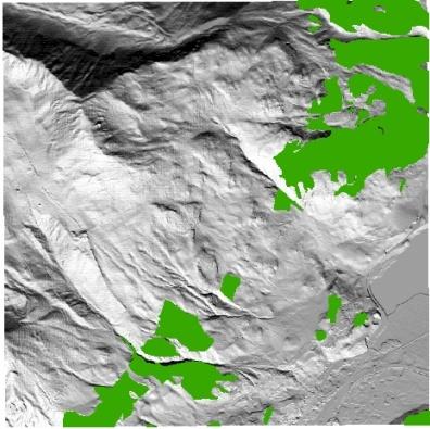

9 Input data Digital Elevation Models DEM Visualization Release zones Maps/aerial imagery Forest WSL Institute for Snow and Avalanche Research SLF
 can have big impact on results -> Check the DEM Spatial resolution 25 to 1m recommended Steep and complex topography (rock faces, gullies, ridges etc.")
10 Digital elevation models DEM Base for numerical calculations DEM errors (holes, artifacts etc.) can have big impact on results -> Check the DEM Spatial resolution 25 to 1m recommended Steep and complex topography (rock faces, gullies, ridges etc.) èhigh spatial resolution needed Terrain changes! Is your DEM up-to-date? 2 m LiDAR DHM25 90 m SRTM RAMMS User Workshop, September 3 th 7 th 2012, Davos, Switzerland
 θ")

 RAMMS (2007) WSL Institute for Snow and")
11 RAMMS::AVALANCHE history θ 0 d 0 Über die Zerstörungskraft von Lawinen, Voellmy (1955) θ p d p U p P Analytical Methods Numerical Methods S d s Anleitung zur Berechnung von Fliesslawinen, Salm (1990) 3D terrain AVAL-1D (2000) RAMMS (2007) WSL Institute for Snow and Avalanche Research SLF
12 WSL Institute for Snow and Avalanche Research SLF
 Avalanche front 0.")


13 Test site Vallée de la Sionne, VS, CH (dry, m 3 ) Avalanche front 0.1 < µ < m/s 2 < ξ < 4000 m/s 2 Avalanche tail 0.3 < µ < m/s 2 < ξ < 1000 m/s 2 Friction parameters vary strongly along the avalanche track!


14 Release Critical parameter, big impact on simulation results Field observation on location (GPS, aerial imagery etc.) Simulating several release areas simultaneously is possible WSL Institute for Snow and Avalanche Research SLF
15 WSL Institute for Snow and Avalanche Research SLF
16 WSL Institute for Snow and Avalanche Research SLF
 Entrainment Different flow regimes (dry, wet and mixed) Powder pressures")
17 RAMMS::AVALANCHE (engineering) Robust Good approximation for avalanche runout, speed and pressures Based on simple and well calibrated Voellmy model Automated generation of friction values (µ and ξ) based on return period and avalanche size Experience and feedback from avalanche engineering RAMMS::AVAL_EXTENDED (research) Entrainment Different flow regimes (dry, wet and mixed) Powder pressures Small scale avalanches Density variations in the core Forest effects 17


18 RAMMS::DEBRISFLOW Initiation zone: Rainfall, landslides, erosion, Transit zone: Erosion + deposition, levee formation, Deposition zone (alluvial fan): Deposition, dewatering, WSL Institute for Snow and Avalanche Research SLF

19


20 Difficult calibration Voellmy friction coefficients: m= , x= m/s 2 Maximum velocity 10 m/s
 Geophones")

21 Illgraben debris flow test site, VS, CH 3 rain gauges Flow height measurements (Radar, Laser) Geophones Debris flow balance Catchment area 9.5 km 2 Shear wall Test ring net Zürich ~2 km, gradient 8-10% Geneva Illgraben


![velocity v [m/s] Discharge](/docs-images/78/77034285/images/22-8.jpg "Q = Av [m 3 /s] WSL")
22 Release debris flow Block Release Block with initial height to match the total volume of debris flow Input Hydrograph Controlled inflow of material according to a discharge hydrograph at specific location Cross-sectional area A [m 2 ] Inflow velocity v [m/s] Discharge Q = Av [m 3 /s] WSL Institute for Snow and Avalanche Research SLF

23 Ongoing research 2 phase model Erosion / deposition More field measurements for calibration Undersaturated Saturated

24 RAMMS::ROCKFALL WSL Institute for Snow and Avalanche Research SLF
 Impact forces Fast calculation of numerous stones Optimized visualization of the results WSL Institute for Snow and Avalanche Research")
25 New 3D model based on physics 100% three dimensional Rigid body contact Real rock shapes Dynamic data: Trajectories (impact points & jump heights) Velocities Rotations(3 axis) Kinetic energies (translation, rotation) Impact forces Fast calculation of numerous stones Optimized visualization of the results WSL Institute for Snow and Avalanche Research SLF


26 Rock shapes Laser scanning 26


27 Rock shapes Contact parameters fixed 40 o WSL Institute for Snow and Avalanche Research SLF

28 Simulation data: Shape files Jump height Velocity WSL Institute for Snow and Avalanche Research SLF


29 Experiments Lab Field Case studies WSL Institute for Snow and Avalanche Research SLF
30 Interpretation of simulation results RAMMS is a numerical model ( reality) Even if the visualization looks very nice, other aspects such as field visit, climatic situation, scenarios, cadastre and expert knowledge are very important. Careful interpretation of the results is mandatory (expert knowledge)! session tomorrow and in the advanced sessions Location of release area, release height and volume have a strong influence on the results experience necessary! Knowledge about the terrain and the avalanche situation is essential!

 Calibration with real scale experiments Output: Flow")
 WSL Institute for Snow and Avalanche")
31 Summary RAMMS is a tool for numerical simulation of rapid mass movements Modules: avalanche, debris flow, rockfall and hillslope Most important input data are the DEM as well as location of release area and release volume Voellmy-Salm model with two friction values (µ & ξ) Calibration with real scale experiments Output: Flow paths, run-out distances, velocities, flow heights, pressures Results must be interpreted by experts (model reality) WSL Institute for Snow and Avalanche Research SLF

32 RAMMS info Software Manuals Information about new software updates News and general information Glossar, features and background-information Forum answers to questions and problemdiscussions
Rapid Mass Movements System RAMMS
 Rapid Mass Movements System RAMMS Yves Bühler, Marc Christen, Perry Bartelt, Christoph Graf, Werner Gerber, Brian McArdell Swiss Federal Institute for Forest, Snow and Landscape Research WSL WSL Institute
Exercise: guided tour
 Exercise: guided tour Yves Bühler & Lukas Stoffel Seminar in snow, slush- and debris flows RAMMS Demonstration, September 3 rd 2013, Longyearbyen, Norway Swiss Federal Institute for Forest, Snow and Landscape
Swiss Avalanche-Dynamics Procedures for Dense Flow Avalanches
 Swiss Avalanche-Dynamics Procedures for Dense Flow Avalanches H. Gubler 1 Swiss Avalanche-Dynamics Procedures for Dense Flow Avalanches H.Gubler AlpuG Richtstattweg2 CH-7270 Davos Platz, Switzerland Introduction
SENSITIVITY ANALYSIS OF THE RAMMS AVALANCHE DYNAMICS MODEL IN A CANADIAN TRANSITIONAL SNOW CLIMATE
 SENSITIVITY ANALYSIS OF THE RAMMS AVALANCHE DYNAMICS MODEL IN A CANADIAN TRANSITIONAL SNOW CLIMATE Ryan Buhler 1 *, Chris Argue 1, Bruce Jamieson 2, and Alan Jones 1 1 Dynamic Avalanche Consulting Ltd.,
Dynamic Avalanche Modeling in Natural Terrain
 Dynamic Avalanche Modeling in Natural Terrain J.T. Fischer,a,b, J. Kowalski a, S.P. Pudasaini b, S. A. Miller b a WSL Institute for Snow and Avalanche Research SLF, Davos Dorf, Switzerland b Department
International Snow Science Workshop Grenoble Chamonix Mont-Blanc
 Towards a basic avalanche characterization based on the generated seismic signal Alec van Herwijnen, Lisa Dreier, Perry Bartelt WSL Institute for Snow and Avalanche Research SLF, Davos, Switzerland ABSTRACT:
Modelling Wet Snow Avalanche Flow with a Temperature Dependent Coulomb Friction Function
 Modelling Wet Snow Avalanche Flow with a Temperature Dependent Coulomb Friction Function César Vera and Perry Bartelt WSL Institute for Snow and Avalanche Research, SLF, Davos, Switzerland ABSTRACT: We
OPTIMIZATION OF COMPUTATIONAL SNOW AVALANCHE SIMULATION TOOLS
 OPTIMIZATION OF COMPUTATIONAL SNOW AVALANCHE SIMULATION TOOLS Jan-Thomas Fischer 1, Andreas Kofler 1, Wolfgang Fellin 2, Matthias Granig 3, Karl Kleemayr 1 1 Austrian Research and Centre for Forests -
Appendix B: Detailed tables showing overall figures by country and measure
 44 country and measure % who report that they are very happy Source: World Values Survey, 2010-2014 except United States, Pew Research Center 2012 Gender and Generations survey and Argentina 32% 32% 36%
Proceedings, International Snow Science Workshop, Innsbruck, Austria, 2018
 Analysis of one avalanche zone in the Eastern Pyrenees (Val d Aran) using historical analysis, snow-climate data and mixed flowing/powder avalanche modelling. Sergi Riba Porras 1, 2 *, Carles García-Sellés
2010 International Snow Science Workshop WET-SNOW AVALANCHE INTERACTING WITH A DEFLECTING DAM: FIELD OBSERVATIONS
 WET-SNOW AVALANCHE INTERACTING WITH A DEFLECTING DAM: FIELD OBSERVATIONS Betty Sovilla 1, Ilaria Sonatore 1,2, Stefan Margreth 1 and Marc Christen 1 1 WSL Institute for Snow and Avalanche Research SLF,
Proceedings, International Snow Science Workshop, Banff, 2014
 EFFECTS OF THE THERMAL CHARACTERISTICS OF SNOW ENTRAINMENT IN AVALANCHE RUN-OUT AT BIRD HILL, SOUTH-CENTRAL ALASKA Katreen Wikstroem Jones 1 *, David Hamre 2 and Perry Bartelt 3 1 Alaska Pacific University,
Proceedings, 2012 International Snow Science Workshop, Anchorage, Alaska
 BACK-CALCULATION OF SMALL AVALANCHES WITH THE 2D AVALANCHE DYNAMICS MODEL RAMMS: FOUR EVENTS ARTIFICIALLY TRIGGERED AT THE SEEHORE TEST SITE IN AOSTA VALLEY (NW ITALY). M. Maggioni 1 *, M. Freppaz 1, M.
Avalanche Guidelines
 improved Accessibility: Reliability and security of Alpine transport infrastructure related to mountainous hazards in a changing climate Avalanche Guidelines guide lines for snow avalanches hazard PP4
2017 Source of Foreign Income Earned By Fund
 2017 Source of Foreign Income Earned By Fund Putnam Emerging Markets Equity Fund EIN: 26-2670607 FYE: 08/31/2017 Statement Pursuant to 1.853-4: The fund is hereby electing to apply code section 853 for
GIS Techniques for Avalanche Path Mapping and Snow Science Observations. By Douglas D. Scott AVALANCHE MAPPING/IDEA INTEGRATION
 GIS Techniques for Avalanche Path Mapping and Snow Science Observations GIS Techniques for Avalanche Path Mapping and Snow Science Observations. By Douglas D. Scott AVALANCHE MAPPING/IDEA INTEGRATION For
Proceedings, International Snow Science Workshop, Breckenridge, Colorado, 2016
 COUPLING OPERATIONAL SNOWCOVER SIMULATIONS WITH AVALANCHE DYNAMICS CALCU- LATIONS TO ASSESS AVALANCHE DANGER IN HIGH ALTITUDE MINING OPERATIONS Vera Valero, César 1 *, Wever, Nander 2 and Bartelt, Perry
COMPARSION of POWDER SNOW AVALANCHE SIMULATION MODELS (RAMMS and SamosAT) BASED on REFERENCE EVENTS in SWITZERLAND
 BASED on REFERENCE EVENTS in SWITZERLAND") COMPARSION of POWDER SNOW AVALANCHE SIMULATION MODELS (RAMMS and SamosAT) BASED on REFERENCE EVENTS in SWITZERLAND Korbinian Schmidtner 1,, Perry Bartelt 2, Jan-Thomas Fischer 3, Rudolf Sailer 1, Matthias
COMPARSION of POWDER SNOW AVALANCHE SIMULATION MODELS (RAMMS and SamosAT) BASED on REFERENCE EVENTS in SWITZERLAND Korbinian Schmidtner 1,, Perry Bartelt 2, Jan-Thomas Fischer 3, Rudolf Sailer 1, Matthias
POLITECNICO DI TORINO
 POLITECNICO DI TORINO Whatever is the numerical approach to the study of rock avalanche evolution, obtained results depend on the choice of the value that is assigned to the characteristic parameters of
Proceedings, International Snow Science Workshop, Banff, 2014
 AUTOMATED RISK MAPPING FOR BUILDINGS ENDANGERED BY AVALANCHES Linda Ettlin*, Michael Bründl, Marc Christen and Yves Bühler WSL Institute for Snow and Avalanche Research SLF, Davos, Switzerland ABSTRACT:
Observations and modelling of snow avalanche entrainment
 Natural Hazards and Earth System Sciences (2002) 2: 169 179 c European Geosciences Union 2002 Natural Hazards and Earth System Sciences Observations and modelling of snow avalanche entrainment B. Sovilla
MASS AND MOMENTUM BALANCE MODEL OF A MIXED FLOWING/POWDER SNOW AVALANCHE
 MASS AND MOMENTUM BALANCE MODEL OF A MIXED FLOWING/POWDER SNOW AVALANCHE B. TURNBULL and P. BARTELT WSL, Swiss Federal Institute for Snow and Avalanche Research SLF, Flüelastrasse 11, 7260 Davos Dorf,
Canadian Imports of Honey
 of 0409000029 - Honey, natural, in containers of a weight > 5 kg, nes (Kilogram) Argentina 236,716 663,087 2,160,216 761,990 35.27% 202.09% /0 76,819 212,038 717,834 257,569 35.88% 205.69% /0 United States
Avalanches. Avalanche s
 Avalanches Avalanche s Avalanches were first imagined as giant snowballs which increased in size from accretion of underlying snow What are avalanches? They are flows which move under the influence of
 Canton du Valais, Service des forêts et du paysage (SFP), section des dangers naturels Kanton Graubünden, Amt für Wald Graubünden, Naturgefahren Regione Valle d Aosta, Dipartimento Difesa del Suolo e Risorse
Canton du Valais, Service des forêts et du paysage (SFP), section des dangers naturels Kanton Graubünden, Amt für Wald Graubünden, Naturgefahren
, section des dangers naturels Kanton Graubünden, Amt für Wald Graubünden, Naturgefahren") Canton du Valais, Service des forêts et du paysage (SFP), section des dangers naturels Kanton Graubünden, Amt für Wald Graubünden, Naturgefahren Regione Valle d Aosta, Dipartimento Difesa del Suolo e Risorse
Canton du Valais, Service des forêts et du paysage (SFP), section des dangers naturels Kanton Graubünden, Amt für Wald Graubünden, Naturgefahren Regione Valle d Aosta, Dipartimento Difesa del Suolo e Risorse
Development of Kanako, a wide use 1-D and 2-D debris flow simulator equipped with GUI
 Monitoring, Simulation, Prevention and Remediation of Dense Debris Flows II 49 Development of Kanako, a wide use 1-D and 2-D debris flow simulator equipped with GUI K. Nakatani, T. Wada, Y. Satofuka &
Geog 1000 Lecture 17: Chapter 10
 Geog 1000 Lecture 17: Chapter 10 Landslides and Mass Movements Link to lectures: http://scholar.ulethbridge.ca/chasmer/classes/ Today s Lecture 1. Assignment 2 Due Pick up Assignment 1 if you don t have
International Conference Analysis and Management of Changing Risks for Natural Hazards November 2014 l Padua, Italy
 Abstract code: D04 Automated Risk Mapping for Buildings Endangered by Natural Hazards L. Ettlin 1, M. Bründl 1, M. Christen 1 and Y. Bühler 1 1 WSL Institute for Snow and Avalanche Research SLF, Davos,
Global Data Catalog initiative Christophe Charpentier ArcGIS Content Product Manager
 Global Data Catalog initiative Christophe Charpentier ArcGIS Content Product Manager ccharpentier@esri.com We are in a global economy Global Economy Business and Operations are now global Strategic need
2010 International Snow Science Workshop
 A HIGH RESOLUTION APPROACH TO DEFINING SPATIAL SNOW HEIGHT DISTRIBUTION IN AVALANCHE RELEASE ZONES FOR DYNAMIC AVALANCHE MODELING Alexander Prokop* and Christina Delaney Institute of Mountain Risk Engineering,
Digital Elevation Models (DEM)
") Digital Elevation Models (DEM) Digital representation of the terrain surface enable 2.5 / 3D views Rule #1: they are models, not reality Rule #2: they always include some errors (subject to scale and data
Digital Elevation Models (DEM) Digital representation of the terrain surface enable 2.5 / 3D views Rule #1: they are models, not reality Rule #2: they always include some errors (subject to scale and data
International and regional network status
 WORLD METEOROLOGICAL ORGANIZATION JOINT MEETING OF CBS EXPERT TEAM ON SURFACE-BASED REMOTELY- SENSED OBSERVATIONS (Second Session) AND CIMO EXPERT TEAM ON OPERATIONAL REMOTE SENSING (First Session) CBS/ET-SBRSO-2
IPWG recent accomplishments and future directions
 IPWG recent accomplishments and future directions Paul Kucera (NCAR, Boulder, USA) And Bozena Lapeta (IMWM Krakow, Poland) with additions by Volker Gärtner (EUMETSAT, IPWG Rapporteur) IPWG Objectives IPWG
Results 2015 from SP 4 FoU Snøskred: Work Package 3 Slushflows
 Page: 1 Results 2015 from SP 4 FoU Snøskred: Work Package 3 Slushflows Project nr : 20140053-400 Title : Slushflows Total budget (knok) From Dept. Of Oil and Energy (knok) Costs per 2015-12-31 (knok) 300
Statistical avalanche run-out modelling using GIS on selected slopes of Western Tatras National park, Slovakia
 Statistical avalanche run-out modelling using GIS on selected slopes of Western Tatras National park, Slovakia Marek Biskupič, 2, * and Ivan Barka 3 Faculty of Science, Charles University in Prague, Czech
Proceedings, International Snow Science Workshop, Banff, 2014
 MERGING OF RECENT DEVELOPMENTS IN AVALANCHE SIMULATION TECHNOLOGY INTO PRACTICE Yves Bühler 1 *, Marc Christen 1, Lisa Dreier 1, Thomas Feistl 1 and Perry Bartelt 1 1 WSL Institute or Snow and Avalanche
Cyclone Click to go to the page. Cyclone
 Cyclone.0311.2 Click to go to the page Cyclone The Cyclone (1,000-8,000 CFM) Suitable for collection of virtually any type of dust Applications: Heavy Moulding Grinding Planing Cabinet Shops Dust Transfer
The Outer Space Legal Regime and UN Register of Space Objects
 The Outer Space Legal Regime and UN Register of Space Objects ITU-R Symposium and Workshop on the Small Satellite Regulation and Communication Systems Prague, Czech Republic, 2-4 March 2015 Niklas Hedman
Quantifying the hazard of catastrophic rock avalanches
 IRASMOS Symposium, Davos, Switzerland, 15-16 May 2008 Quantifying the hazard of catastrophic rock avalanches Acknowledging John J. Clague Ken Hewitt Reginald L. Hermanns Isaac J. Larsen Alexander L. Strom
A probabilistic approach for landslide hazard analysis
 A probabilistic approach for landslide hazard analysis S. Lari, P. Frattimi, G.B. Crosta Engineering Geology 182 (2014) 3-14 報告者 : 符智傑 指導教授 : 李錫堤老師 報告日期 :2016/05/05 Introduction A general framework for
USDA Dairy Import License Circular for 2018
 USDA Dairy Import License Circular for 2018 Commodity/Note Country Name TRQ Jan Feb Mar Apr May Jun Jul Aug Sep Oct Nov Grand Total Non-Cheese 21,864,781 624,064 651,121 432,669 901,074 1,202,567 907,493
Hazard assessment Sveltihel Marmierfjellet
 Report Hazard assessment Sveltihel Marmierfjellet Subject: Mapping of natural hazards near Sventihel Date: 19. July 2017 Contents Introduction... 5 1.1 Purpose of mapping and detail level... 5 2. General
Securing EUMETSAT s Mission from an Evolving Space Environment
 Securing EUMETSAT s Mission from an Evolving Space Environment ESPI 12 th Autumn Conference Andrew Monham 1 EUMETSAT: Intergovernmental Organisation of 30 Member States Presentation Contents AUSTRIA BELGIU
A COMPREHENSIVE WORLDWIDE WEB-BASED WEATHER RADAR DATABASE
 A COMPREHENSIVE WORLDWIDE WEB-BASED WEATHER RADAR DATABASE Oguzhan SİRECİ 1, Paul JOE 2, Serkan EMINOGLU 3, Kamuran AKYILDIZ 4 1 Turkish State Meteorological Service(TSMS), Kecioren, Ankara Turkey,osireci@gmail.com
Pan-Arctic Digital Elevation Map (Pan-Arctic DEM)
") Memorandum to CAFF Board 07/28/2017 BACKGROUND: Pan-Arctic Digital Elevation Map (Pan-Arctic DEM) ArcticDEM is a National Geospatial-Intelligence Agency (NGA)-National Science Foundation (NSF) publicprivate
Memorandum to CAFF Board 07/28/2017 BACKGROUND: Pan-Arctic Digital Elevation Map (Pan-Arctic DEM) ArcticDEM is a National Geospatial-Intelligence Agency (NGA)-National Science Foundation (NSF) publicprivate
APPLICATION AND LIMITATIONS OF DYNAMIC MODELS FOR SNOW AVALANCHE HAZARD MAPPING
 APPLICATION AND LIMITATIONS OF DYNAMIC MODELS FOR SNOW AVALANCHE HAZARD MAPPING Bruce Jamieson 1, Stefan Margreth 2, Alan Jones 3 1 University of Calgary, Calgary, Canada 2 WSL Swiss Federal Institute
SDG s and the role of Earth Observation
 SDG s and the role of Earth Observation Christian Heipke IPI - Institute for Photogrammetry and GeoInformation Leibniz Universität Hannover Germany Secretary General, ISPRS 1. No Poverty 2. Zero Hunger
Regional snow-depth estimates for avalanche calculations using a two-dimensional model with snow entrainment
 Annals of Glaciology 49 2008 63 Regional snow-depth estimates for avalanche calculations using a two-dimensional model with snow entrainment Emanuela BIANCHI JANETTI, 1,2 Elisa GORNI, 1,2 Betty SOVILLA,
USDA Dairy Import License Circular for 2018 Commodity/
 USDA Dairy Import License Circular for 2018 Commodity/ Grand Country Name TRQ Jan Feb Mar Apr May Jun Jul Aug Sep Note Total Non-Cheese 21,864,781 624,064 651,121 432,669 901,074 1,202,567 907,493 1,117,261
Using Weather and Climate Information for Landslide Prevention and Mitigation
 Using Weather and Climate Information for Landslide Prevention and Mitigation Professor Roy C. Sidle Disaster Prevention Research Institute Kyoto University, Japan International Workshop on Climate and
Pinyol, Jordi González, Marta Oller, Pere Corominas, Jordi Martínez, Pere
 Rockfall hazard mapping methodology applied to the Geological Hazard Prevention Map in Catalonia 1:25000 Pinyol, Jordi González, Marta Oller, Pere Corominas, Jordi Martínez, Pere ROCKFALL HAZARD MAPPING
GEO The Åknes rock slope. Content. Dr. Vidar Kveldsvik NGI
 GEO 4180 The Åknes rock slope Dr. Vidar Kveldsvik NGI Content Background on large rock slides Triggers Stability analysis Risk mitigation (risk reduction) The Åknes rock slope 1 Background Landslides due
A Roundup of Recent Debris Flow Events in Taiwan
 2015 International Workshop on Typhoon and Flood APEC Experience Sharing on Hazardous Weather Events and Risk Management A Roundup of Recent Debris Flow Events in Taiwan Hsiao-Yuan(Samuel) Yin Ph.D. sammya@mail.swcb.gov.tw
GLACIAL LAKE OUTBURST FLOODS IN THE NEPAL HIMALAYA JONATHAN M LALA UNIVERSITY OF TEXAS AT AUSTIN CE 394K.3 GIS IN WATER RESOURCES DECEMBER 2, 2016
 GLACIAL LAKE OUTBURST FLOODS IN THE NEPAL HIMALAYA JONATHAN M LALA UNIVERSITY OF TEXAS AT AUSTIN CE 394K.3 GIS IN WATER RESOURCES DECEMBER 2, 2016 TABLE OF CONTENTS Abstract... 3 Introduction... 3 Methods...
International Snow Science Workshop, Davos 2009, Proceedings
 COMPARISON AND COMPLEMENTARITIES OF AVALANCHE PRESSURE MEASUREMENTS: PIEZO-ELECTRIC LOAD CELLS AND DEFORMATION BASED PRESSURE DECONVOLUTION Djebar BAROUDI 1, Betty SOVILLA 2, Emmanuel THIBERT 1 1 Cemagref,
Christoph Graf Brian W. McArdell. WSL Swiss Federal Research Institute Zürcherstrasse 111 CH - Birmensdorf.
 Debris-flow monitoring and debris-flow runout modelling before and after construction of mitigation measures : an example from an instable zone in the Southern Swiss Alps Christoph Graf Brian W. McArdell
Landslides & Debris Flows
 T.#Perron# #12.001# #Landslides#&#Debris#Flows# 1# Landslides & Debris Flows Many geologic processes, including those shaping the land surface, are slowacting, involving feedbacks that operate over many
Plume Formation in Powder Snow Avalanches
 Plume Formation in Powder Snow Avalanches Perry Bartelt 1, *, Yves Bühler, Othmar Buser and Christian Ginzler 2 1 WSL Institute for Snow and Avalanche Research, SLF, Davos, Switzerland. 2 WSL Institute
LINKING SNOW COVER PROPERTIES AND AVALANCHE DYNAMICS
 LINKING SNOW COVER PROPERTIES AND AVALANCHE DYNAMICS Walter Steinkogler 1,2, Betty Sovilla 1 and Michael Lehning 1,2 1 WSL Institute for Snow and Avalanche Research SLF, Davos Dorf, Switzerland 2 CRYOS,
USING GIS FOR AVALANCHE SUSCEPTIBILITY MAPPING IN RODNEI MOUNTAINS
 USING GIS FOR AVALANCHE SUSCEPTIBILITY MAPPING IN RODNEI MOUNTAINS IOANA SIMEA 1 ABSTRACT. Using GIS for avalanche susceptibility mapping in Rodnei Mountains. This case study combines GIS methods with
Background. Points of Discussion. Hydrographic Models
 Airborne Laser Remote Sensing Technology: Providing Essential Hydrologic Information in the 21 st Century Warwick Hadley, Optech Incorporated Presented by: Warwick Hadley Sales Manager, Middle East and
The PREVIEW project: general objectives and an overview of the landslides platform
 The PREVIEW project: general objectives and an overview of the landslides platform Risk Mitigation for Earthquakes and Landslides Giacomo Falorni Earth Sciences Dept. University of Firenze 19-20 July 2007
Haydar Hussin (1), Roxana Ciurean (2), Paola Reichenbach (1), Cees van Westen (3), Gianluca Marcato (4), Simone Frigerio (4), V. Juliette Cortes (4)
, Roxana Ciurean (2), Paola Reichenbach (1), Cees van Westen (3), Gianluca Marcato (4), Simone Frigerio (4), V. Juliette Cortes (4)") 7/10/2013 Changing Hydro-meteorological Risks - as Analyzed by a New Generation of European Scientists Probabilistic 2D numerical landslide modeling: a first step towards assessing changes in risk due
7/10/2013 Changing Hydro-meteorological Risks - as Analyzed by a New Generation of European Scientists Probabilistic 2D numerical landslide modeling: a first step towards assessing changes in risk due
Field observations, full-scale tests, laboratory investigations and numerical modelling of snow avalanches in Switzerland
 Avalanche Dynamics Field observations, full-scale tests, laboratory investigations and numerical modelling of snow avalanches in Switzerland Betty Sovilla*, Marc Christen, Francois Dufour, Urs Gruber,
NWC SAF Product Assessment Review Workshop
 NWC SAF Product Assessment Review Workshop LF López Cotín. IOP NWC SAF Manager Madrid, 17 th to19 th October2005 NWC SAF User Feedback Standard user feedback: Helpdesk, SPRs and SMRs procedure Email Strategy
CONTINENT WISE ANALYSIS OF ZOOLOGICAL SCIENCE PERIODICALS: A SCIENTOMETRIC STUDY
 CONTINENT WISE ANALYSIS OF ZOOLOGICAL SCIENCE PERIODICALS: A SCIENTOMETRIC STUDY Mr.Chopkar Hemraj D. Librarian NKSPT S Arts, Science & Commerce College, Badnapur. (MS) India Mr. Phatak Anil Shahaji Research
Production Line Tool Sets
 Production Line Tool Sets Tools for high-quality database production and cartographic output Production Line Tool Sets Production Line Tool Sets (PLTS) by ESRI are a collection of software applications
USDA Dairy Import License Circular for 2018
 USDA Dairy Import License Circular for 2018 Commodity/Note Country Name TRQ Jan Feb Mar Apr May Jun Grand Total Non-Cheese 21,864,781 624,064 651,121 432,669 901,074 1,202,567 907,493 4,718,988 BUTTER
Modeling mass-dependent flow regime transitions to predict the stopping and depositional behavior of snow avalanches
 JOURNAL OF GEOPHYSICAL RESEARCH, VOL. 117,, doi:10.1029/2010jf001957, 2012 Modeling mass-dependent flow regime transitions to predict the stopping and depositional behavior of snow avalanches P. Bartelt,
Export Destinations and Input Prices. Appendix A
 Export Destinations and Input Prices Paulo Bastos Joana Silva Eric Verhoogen Jan. 2016 Appendix A For Online Publication Figure A1. Real Exchange Rate, Selected Richer Export Destinations UK USA Sweden
Terranum Sàrl. Rock-solid Expertise and Software
 Terranum Sàrl Rock-solid Expertise and Software About Founded in May 2011, Terranum Sàrl develops rock-solid expertise for natural hazards, geology, hydrology, 3D and LiDAR measurements, and customized
RISK ASSESSMENT METHODOLOGIES FOR LANDSLIDES
 RISK ASSESSMENT METHODOLOGIES FOR LANDSLIDES Jean-Philippe MALET Olivier MAQUAIRE CNRS & CERG. Welcome to Paris! 1 Landslide RAMs Landslide RAM A method based on the use of available information to estimate
Tool 2.1.4: Inundation modelling of present day and future floods
 Impacts of Climate Change on Urban Infrastructure & the Built Environment A Toolbox Tool 2.1.4: Inundation modelling of present day and future floods Authors M. Duncan 1 and G. Smart 1 Affiliation 1 NIWA,
Down-stream process transition (f (q s ) = 1)
 = 1)") Down-stream process transition (f (q s ) = 1) Detachment Limited S d >> S t Transport Limited Channel Gradient (m/m) 10-1 Stochastic Variation { Detachment Limited Equilibrium Slope S d = k sd A -θ d S
Down-stream process transition (f (q s ) = 1) Detachment Limited S d >> S t Transport Limited Channel Gradient (m/m) 10-1 Stochastic Variation { Detachment Limited Equilibrium Slope S d = k sd A -θ d S
Eagle Creek Post Fire Erosion Hazard Analysis Using the WEPP Model. John Rogers & Lauren McKinney
 Eagle Creek Post Fire Erosion Hazard Analysis Using the WEPP Model John Rogers & Lauren McKinney Columbia River Gorge at Risk: Using LiDAR and GIS-based predictive modeling for regional-scale erosion susceptibility
Scaling Issues Related to Snow Storage and Measurements
 GENDIATUR, QUE REIUNT EXPLABO. UT ASINCTIIS DE VOLLACCAB ISUNT ET EOS QUATIANDANDI DELLECU LLUPTIIST Scaling Issues Related to Snow Storage and Measurements By Wolf Marchand, Sweco Norge AS 1 2017-12-12
Watershed Delineation in GIS Environment Rasheed Saleem Abed Lecturer, Remote Sensing Centre, University of Mosul, Iraq
 Watershed Delineation in GIS Environment Rasheed Saleem Abed Lecturer, Remote Sensing Centre, University of Mosul, Iraq Abstract: The management and protection of watershed areas is a major issue for human
How Well Are Recessions and Recoveries Forecast? Prakash Loungani, Herman Stekler and Natalia Tamirisa
 How Well Are Recessions and Recoveries Forecast? Prakash Loungani, Herman Stekler and Natalia Tamirisa 1 Outline Focus of the study Data Dispersion and forecast errors during turning points Testing efficiency
GEOSPATIAL ANALYSIS OF GLACIAL DYNAMICS OF SHIGAR AND SHAYOK BASINS. Syed Naseem Abbas Gilany 1
 GEOSPATIAL ANALYSIS OF GLACIAL DYNAMICS OF SHIGAR AND SHAYOK BASINS 1 OUTLINE Introduction Problem Statement / Rationale Objectives Material and Methods Study Area Datasets Required Data Analysis / Assessment
Slow drag in wet-snow avalanche flow
 Journal of Glaciology, Vol. 56, No. 198, 2010 587 Slow drag in wet-snow avalanche flow B. SOVILLA, 1 M. KERN, 2 M. SCHAER 3 1 Avalanches, Debris Flows and Rockfall Research Unit, WSL Institute for Snow
Spatial modelling of snow avalanche run-outs using GIS
 Spatial modelling of snow avalanche run-outs using GIS Marek, Biskupič, 2, Ivan, Barka 3 Institute of Environmental studies, Faculty of Science, Charles University in Prague, Benátská 2, 280, Praha 2,
Hydrologic Modelling of the Upper Malaprabha Catchment using ArcView SWAT
 Hydrologic Modelling of the Upper Malaprabha Catchment using ArcView SWAT Technical briefs are short summaries of the models used in the project aimed at nontechnical readers. The aim of the PES India
Debris flows + sediment transport in torrents. Debris flows and sediment. transport in steep catchments
 International Workshop "Erosion, Transport Debris flows and sediment transport in steep catchments Dieter Rickenmann WSL - Swiss Federal Research Institute, Mountain Hydrology and Torrents, Birmensdorf,
Conservation Planning evaluate land management alternatives to reduce soil erosion to acceptable levels. Resource Inventories estimate current and
 Conservation Planning evaluate land management alternatives to reduce soil erosion to acceptable levels. Resource Inventories estimate current and projected erosion levels and their impact on natural resource
Landslide Susceptibility, Hazard, and Risk Assessment. Twin Hosea W. K. Advisor: Prof. C.T. Lee
 Landslide Susceptibility, Hazard, and Risk Assessment Twin Hosea W. K. Advisor: Prof. C.T. Lee Date: 2018/05/24 1 OUTLINE INTRODUCTION LANDSLIDE HAZARD ASSESSTMENT LOGISTIC REGRESSION IN LSA STUDY CASE
USING GIS CARTOGRAPHIC MODELING TO ANALYSIS SPATIAL DISTRIBUTION OF LANDSLIDE SENSITIVE AREAS IN YANGMINGSHAN NATIONAL PARK, TAIWAN
 CO-145 USING GIS CARTOGRAPHIC MODELING TO ANALYSIS SPATIAL DISTRIBUTION OF LANDSLIDE SENSITIVE AREAS IN YANGMINGSHAN NATIONAL PARK, TAIWAN DING Y.C. Chinese Culture University., TAIPEI, TAIWAN, PROVINCE
PREDICTION OF RUN-OUT PROCESS FOR A DEBRIS FLOW TRIGGERED BY A DEEP RAPID LANDSLIDE
 DOI: 10.4408/IJEGE.2011-03.B-053 PREDICTION OF RUN-OUT PROCESS FOR A DEBRIS FLOW TRIGGERED BY A DEEP RAPID LANDSLIDE Y. NISHIGUCHI (*), T. UCHIDA (*), K. TAMURA (*) & Y. SATOFUKA (**) (*) Public Works
Application of RAMMS::ROCKFALL and ROCKYFOR3D in protective measure planning
 ecorisq General Assembly 2015 Application of RAMMS::ROCKFALL and ROCKYFOR3D in protective measure planning A short report of user experiences BFW Innsbruck R. Kühne, tur gmbh Davos 1 Introduction Objective
Contribution to the Mountain-Risks project of the Rock Mechanics Laboratory of the Swiss Federal Institute of Technology of Lausanne
 Contribution to the Mountain-Risks project of the Rock Mechanics Laboratory of the Swiss Federal Institute of Technology of Lausanne PhD Student: Jacopo Abbruzzese Supervisor: Dr. Vincent Labiouse MOUNTAIN
Interfacing with the industry needs euro geotecnica, s.a.
 Interfacing with the industry needs Avda. Corts Catalanes 5-7 2ª planta 08173 Sant Cugat del Vallès. Barcelona. Telèfon: 93 583 04 80 / Fax: 93 583 69 60 Table of contents Introduction Natural hazards
I&CLC2000 in support to new policy initiatives (INSPIRE, GMES,..)
") I&CLC2000 in support to new policy initiatives (INSPIRE, GMES,..) Manfred Grasserbauer, Director Joint Research Centre Institute for Environment and Sustainability 1 IMAGE 2000 European mosaic of satellite
I&CLC2000 in support to new policy initiatives (INSPIRE, GMES,..) Manfred Grasserbauer, Director Joint Research Centre Institute for Environment and Sustainability 1 IMAGE 2000 European mosaic of satellite
Debris flow mitigation with flexible ring net barriers field tests and case studies
 Monitoring, Simulation, Prevention and Remediation of Dense Debris Flows II 23 Debris flow mitigation with flexible ring net barriers field tests and case studies C. Wendeler 1, B. W. McArdell 1, A. Volkwein
04 June Dim A W V Total. Total Laser Met
 4 June 218 Member State State as on 4 June 218 Acronyms are listed in the last page of this document. AUV Mass and Related Quantities Length PR T TF EM Mass Dens Pres F Torq Visc H Grav FF Dim A W V Total
International Conference Analysis and Management of Changing Risks for Natural Hazards November 2014 l Padua, Italy
 Abstract Code: B01 Assets mapping products in support of preparedness and prevention measures (examples from Germany, Italy and France) Marc Mueller, Thierry Fourty, Mehdi Lefeuvre Airbus Defence and Space,
An operational supporting tool for assessing wet-snow avalanche danger
 An operational supporting tool for assessing wet-snow avalanche danger Christoph Mitterer*, Frank Techel, Charles Fierz and Jürg Schweizer WSL Institute for Snow and Avalanche Research SLF, Davos, Switzerland
FLOOD RISK MAPPING AND ANALYSIS OF THE M ZAB VALLEY, ALGERIA
 River Basin Management IX 69 FLOOD RISK MAPPING AND ANALYSIS OF THE M ZAB VALLEY, ALGERIA AMEL OUCHERIF & SAADIA BENMAMAR National Polytechnic School of Algiers, Algeria ABSTRACT To contribute to flood
Exploring the role of new technologies in quantifying precipitation levels and urban flooding
 Exploring the role of new technologies in quantifying precipitation levels and urban flooding Jörg Rieckermann Urban Water Management Eawag, Swiss Federal Institute of Aquatic Science and Technology Motivation
International Student Enrollment Fall 2018 By CIP Code, Country of Citizenship, and Education Level Harpur College of Arts and Sciences
 International Student Enrollment Fall 2018 By CIP Code, Country of Citizenship, and Education Level Harpur College of Arts and Sciences CIP Code Description Citizenship Graduate Undergrad Total 00.0000
Results 2016 from SP 4 FoU Snøskred: Work Package 1 Ryggfonn and Avalanche Dynamics
 Page: 1 Results 2016 from SP 4 FoU Snøskred: Work Package 1 Ryggfonn and Avalanche Dynamics Project nr : 20140053-200 Title : Ryggfonn and avalanche dynamics Total budget (knok) From Dept. Of Oil and Energy