GIS Techniques for Avalanche Path Mapping and Snow Science Observations. By Douglas D. Scott AVALANCHE MAPPING/IDEA INTEGRATION
|
|
|
- Jewel Richardson
- 6 years ago
- Views:
Transcription

1 GIS Techniques for Avalanche Path Mapping and Snow Science Observations GIS Techniques for Avalanche Path Mapping and Snow Science Observations. By Douglas D. Scott AVALANCHE MAPPING/IDEA INTEGRATION
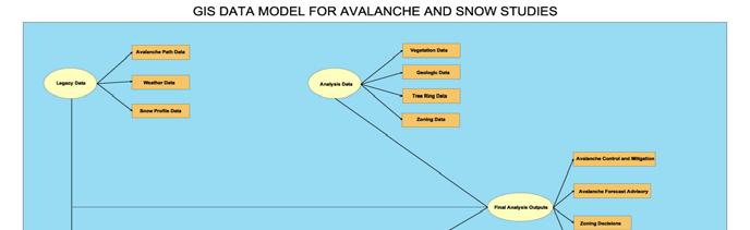
2 For many years the Swiss, Canadian and other snow scientist have been using GIS to monitor, document, and model avalanche occurrence, snow profiles, and weather. In the United States the use has been limited ited to only a few areas. Until recently almost all avalanche and snowpit data observations were recorded on hard copy and or did not have a spatial component. With the current advances in technology this has become affordable and reasonable to implement. This paper presents the techniques for building avalanche atlas maps, sourced from newly collected and legacy data. This will also present the integration of a digital ital snowpit profile program for the pocket pc with ArcPad and GPS for the collection of snowpit observation data that has a spatial reference. These advances will w make it possible to bring observations and data into a GIS for referencing, r modeling, and sharing. The historical avalanche path data is loaded in to a database that can relate the hard copy snowpit and weather data. These data layers can be displayed over other GIS base layers such as DEM, DRG, DOQ, soils/geology, and vegetation cover. Integration of realtime weather and snow profile data can be added to this for analysis. Digital data collection tools will be displayed that can load new data directly in to a GIS Database with little hand entry. Page 1
3 Page 2
, snowpit,, and weather data can be")
4 Historical (legacy) data can be used as references in the t GIS when the hand drawn avalanche paths are digitized and loaded in to a geodatabase.. Avalanche path data (consisting of avalanche archive records and photographs, avalanche mapping of starting zones, size, frequency and area extent of danger), snowpit,, and weather data can be converted from hard copy to digital. The weather data is often in digital and can be linked or loaded to the avalanche and snowpit profile database as well. Page 3
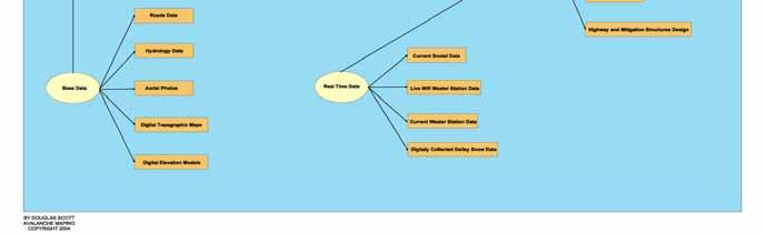
5 The base data layers such as DRG (digital topo map) and DOQ (aerial photography) provide visual information and the ability to identify avalanche terrain. These can also help in referencing the t topography of the avalanche areas. The DEM (digital elevation model) allows various terrain analyses: mean slope, minimum slope, maximum slope, mean aspect, and curvature. When the avalanche path data is overlaid on the DEM it can be analyzed using the nearest neighbor model. This data type is becoming more readily available and at higher resolution (most of the US is now available at 10m and there is 2 meter data for some areas) and accuracy. Much of it is free from the USGS or the USDA as well as many state te GIS data clearing houses. Other important GIS data layers are the hydrography (rivers, streams and lakes), geology, vegetation, tree ring, buildings and roads. Hydrography data shows drainages where avalanches could be constructed by potential terrain traps. Vegetation and geologic layers and often combined with slope angles and curvature to help gauge friction parameters (destructive force) from the various sizes s of the volume of the avalanche s s release. Tree ring data can help document and predict the frequency and sizes of avalanches along their tracks. Building zoning and road data can define potential areas that will suffer destruction. Page 4


6 The 2004 United States Observational Guidelines were used as the template for the GIS geodatabase design. Page 5


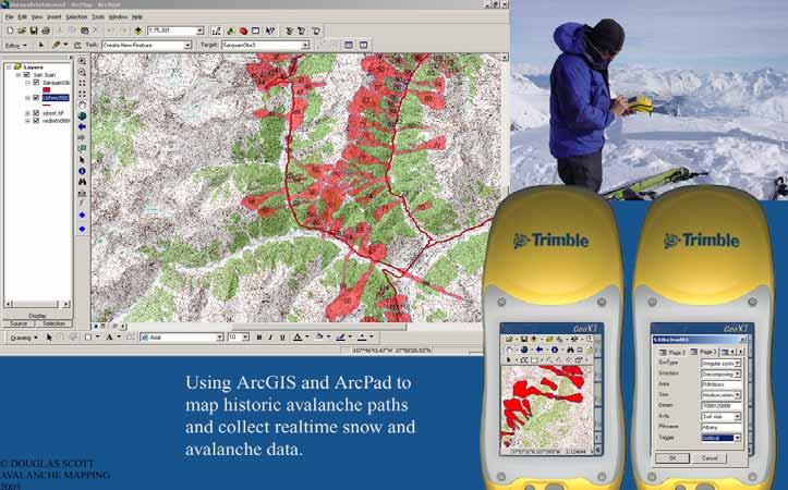
7 The analyst can use the GIS to combine this data with real r time weather and snow data of the area by modern digital collection tools to assess risk and level of danger. The advent of pocket computers and mobile GIS/GPS G software has made it possible to collect digital field data about t avalanche paths and snow profiles. This data can be integrated with the historical avalanche database after it has been brought into the digital framework. Likewise it is possible to take the historical data into the field for a reference and create a new file for the latest occurrence. By collecting a new weather and snow profile and giving it a spatial position with w a GPS point it possible to hyperlink snowpit profile graphs, photographs, and weather station locations to a specific spatial place. This is useful u in viewing the changes to a particular place over a season and the ability to quickly call up past information. Snow Profile Page 6
8 Page 7
9 Remote weather stations can send weather data every half f hour by phone line or wireless transmission. Through the internet a weather program called Meteorologix can bring real time Doppler radar weather images directly into the GIS software view window. As well as digital collection by hand held computer from traditional weather and snow observation sites. With these new tools it is possible to have this real time data quickly and it is easily joined with and compared to past years Regional and local datasets can analyzed and then be used to create various map/computer outputs: Snow depth and cover stability, avalanche hazard/locater (atlas), frequency, damage, forecast, risk, and zoning maps. These can be useful for forecasting, control work, zoning plans and the need for mitigation structures. s. In conclusion, there are many benefits to using GIS and digital data for avalanche and snow science. This paper documented the various data types and their possible applications. It also demonstrated some of the new tools available for data collection and the way in which weather information can be delivered in real time. Page 8
10 References: Gruber, U., 2001: Using GIS for Avalanche Hazard Mapping in Switzerland. From the 2001 ESRI User Conference. Stoffel,, A., Brabec,, B., Stockli,, U., 2001: GIS Applications at the Swiss Federal Institute of Snow and Avalanche Research. Maggioni,, M., Gruber, U., Stoffel,, A., 2002: Definition and Characterisation of Potential Avalanche Release Areas. Swiss Federal Institute of Snow and Avalanche Research. McLaren,, S., 2000: Suitability Mapping of Avalanche Trigger Sites on the North Shore Mountains, Vancouver using a Digital Elevation Model and GIS. UniGIS,, Simon Fraser University. Tracy, L., 2001: GIS in Avalanche Hazard Management. Iceland Meteorological Office. Comunello,, G., Ciolli,, M., Cherubini,, P., 2001: Mapping Avalanche Risk using GIS and Dendrochronological Techniques. From, Conference Tree Rings and People, Davos,, Switzerland. McCollister,, C., Birkeland,, K., Hansen, K., Aspinall,, R., Comey,, R., Exploring Mulit-scale Spatial Patterns in Historical Avalanche Data, Jackson Hole Mountain Resort, Wyoming. Presented 2002 International Snow Science Workshop. Canadian Avalanche Association, 2002: Guidelines for Snow Avalanche Risk Determination and Mapping in Canada. Canadian Avalanche Association, 2004: The Course Profile for; The Introduction to Snow Avalanche Mapping Course.
11 Biography: DOUGLAS SCOTT CONSULTANT IDEA INTEGRATION/AVALANCHE MAPPING 637 B, S BROADWAY, #247 BOULDER, CO ddscott@avalanchemapping.org Currently a GIS Consultant. Former ski patrolman and helicopter ski guide with a Level II American Avalanche School certificate, 30 years of winter mountaineering experience in North America and Europe. I am an Authorized ESRI Instructor and recently created ArcPad skins for the Juniper Systems Archer and Allegro CX.
OVERVIEW OF THE SPATIAL DISTRIBUTION OF AVALANCHE ACTIVITY IN RELATION TO METEOROLOGICAL AND TOPOGRAPHIC VARIABLES IN AN EXTREME MARITIME ENVIRONMENT
 OVERVIEW OF THE SPATIAL DISTRIBUTION OF AVALANCHE ACTIVITY IN RELATION TO METEOROLOGICAL AND TOPOGRAPHIC VARIABLES IN AN EXTREME MARITIME ENVIRONMENT Jordy Hendrikx a*, Ian Owens a, Wayne Carran b, Ann
Exercise: guided tour
 Exercise: guided tour Yves Bühler & Lukas Stoffel Seminar in snow, slush- and debris flows RAMMS Demonstration, September 3 rd 2013, Longyearbyen, Norway Swiss Federal Institute for Forest, Snow and Landscape
The 3D Elevation Program: Overview. Jason Stoker USGS National Geospatial Program ESRI 2015 UC
 + The 3D Elevation Program: Overview Jason Stoker USGS National Geospatial Program ESRI 2015 UC + 2 A little history USGS has a long, proud tradition of mapmaking (2009) + 3 The changing times Mapping
A GIS View of Hydrology
 Quantitative Elements of Hydrology A GIS View of Hydrology Contact information: Jack Hermance Environmental Geophysics/Hydrology Department of Geological Sciences Brown University, Providence, RI 02912-1846
Pierce Cedar Creek Institute GIS Development Final Report. Grand Valley State University
 Pierce Cedar Creek Institute GIS Development Final Report Grand Valley State University Major Goals of Project The two primary goals of the project were to provide Matt VanPortfliet, GVSU student, the
GIS (GEOGRAPHIC INFORMATION SYSTEMS)
") GIS (GEOGRAPHIC INFORMATION SYSTEMS) 1 1. DEFINITION SYSTEM Any organised assembly of resources and procedures united and regulated by interaction or interdependence to complete a set of specific functions.
GIS (GEOGRAPHIC INFORMATION SYSTEMS) 1 1. DEFINITION SYSTEM Any organised assembly of resources and procedures united and regulated by interaction or interdependence to complete a set of specific functions.
NR402 GIS Applications in Natural Resources
 NR402 GIS Applications in Natural Resources Lesson 1 Introduction to GIS Eva Strand, University of Idaho Map of the Pacific Northwest from http://www.or.blm.gov/gis/ Welcome to NR402 GIS Applications in
Introduction to Geographic Information Systems (GIS): Environmental Science Focus
: Environmental Science Focus") Introduction to Geographic Information Systems (GIS): Environmental Science Focus September 9, 2013 We will begin at 9:10 AM. Login info: Username:!cnrguest Password: gocal_bears Instructor: Domain: CAMPUS
Introduction to Geographic Information Systems (GIS): Environmental Science Focus September 9, 2013 We will begin at 9:10 AM. Login info: Username:!cnrguest Password: gocal_bears Instructor: Domain: CAMPUS
GeoWEPP Tutorial Appendix
 GeoWEPP Tutorial Appendix Chris S. Renschler University at Buffalo - The State University of New York Department of Geography, 116 Wilkeson Quad Buffalo, New York 14261, USA Prepared for use at the WEPP/GeoWEPP
Introduction to GIS. Geol 4048 Geological Applications of Remote Sensing
 Introduction to GIS Geol 4048 Geological Applications of Remote Sensing GIS History: Before Computers GIS History Using maps for a long time Dr. Roger F. Tomlinson Father of GIS He was an English geographer
W. Douglas Wewer 1,2 *, Michael J. Jenkins 1
 A PRACTITIONER S PERSPECTIVE: PROVIDING TIMELY AND RELEVANT MOUNTAIN WEATHER INFORMATION TO AVALANCHE WORKERS AT SNOWBASIN, A SUN VALLEY RESORT AND THE FOREST SERVICE UTAH AVALANCHE CENTER W. Douglas Wewer
Flood Hazard Inundation Mapping. Presentation. Flood Hazard Mapping
 Flood Hazard Inundation Mapping Verne Schneider, James Verdin, and JeradBales U.S. Geological Survey Reston, VA Presentation Flood Hazard Mapping Requirements Practice in the United States Real Time Inundation
GIS and Forest Engineering Applications FE 257 Lecture and laboratory, 3 credits
 GIS and Forest Engineering Applications FE 257 Lecture and laboratory, 3 credits Instructor: Michael Wing Associate Professor Forest Engineering, Resources, and Management Oregon State University Crop
Pan-Arctic Digital Elevation Map (Pan-Arctic DEM)
") Memorandum to CAFF Board 07/28/2017 BACKGROUND: Pan-Arctic Digital Elevation Map (Pan-Arctic DEM) ArcticDEM is a National Geospatial-Intelligence Agency (NGA)-National Science Foundation (NSF) publicprivate
Memorandum to CAFF Board 07/28/2017 BACKGROUND: Pan-Arctic Digital Elevation Map (Pan-Arctic DEM) ArcticDEM is a National Geospatial-Intelligence Agency (NGA)-National Science Foundation (NSF) publicprivate
What s New in Topographic Information - USGS National Map
 + What s New in Topographic Information - USGS National Map SARGIS Workshop November 14, 2016 Rob Dollison, 703-648-5724 rdollison@usgs.gov + USGS 2 National Geospatial Program The National Geospatial
Fire Susceptibility Analysis Carson National Forest New Mexico. Can a geographic information system (GIS) be used to analyze the susceptibility of
 be used to analyze the susceptibility of") 1 David Werth Fire Susceptibility Analysis Carson National Forest New Mexico Can a geographic information system (GIS) be used to analyze the susceptibility of Carson National Forest, New Mexico to forest
1 David Werth Fire Susceptibility Analysis Carson National Forest New Mexico Can a geographic information system (GIS) be used to analyze the susceptibility of Carson National Forest, New Mexico to forest
ISU GIS CENTER S ARCSDE USER'S GUIDE AND DATA CATALOG
 ISU GIS CENTER S ARCSDE USER'S GUIDE AND DATA CATALOG 2 TABLE OF CONTENTS 1) INTRODUCTION TO ARCSDE............. 3 2) CONNECTING TO ARCSDE.............. 5 3) ARCSDE LAYERS...................... 9 4) LAYER
Proceedings, International Snow Science Workshop, Banff, 2014
 RELATING AVALANCHES TO LARGE-SCALE OCEAN ATMOSPHERIC OSCILLATIONS Scott Thumlert 1, Sascha Bellaire 2, Bruce Jamieson 1 1 Dept. of Civil Engineering, University of Calgary, AB, Canada 2 Institute of Meteorology
Rapid Mass Movement Simulation RAMMS
 R Rapid Mass Movement Simulation RAMMS Yves Bühler, Marc Christen, Perry Bartelt, SLF Christoph Graf & Brian McArdell, WSL WSL Institute for Snow and Avalanche Research SLF Switzerland: long tradition
Great Lakes Update. Geospatial Technologies for Great Lakes Water Management. Volume 149 October 4, US Army Corps of Engineers Detroit District
 Volume 149 October 4, 2002 US Army Corps of Engineers Detroit District Great Lakes Update Geospatial Technologies for Great Lakes Water Management The U.S. Army Corps of Engineers (USACE) serves an important
Techniques for Science Teachers: Using GIS in Science Classrooms.
 Techniques for Science Teachers: Using GIS in Science Classrooms. After ESRI, 2008 GIS A Geographic Information System A collection of computer hardware, software, and geographic data used together for
Regional Flash Flood Guidance and Early Warning System
 WMO Training for Trainers Workshop on Integrated approach to flash flood and flood risk management 24-28 October 2010 Kathmandu, Nepal Regional Flash Flood Guidance and Early Warning System Dr. W. E. Grabs
Lecture 9: Reference Maps & Aerial Photography
 Lecture 9: Reference Maps & Aerial Photography I. Overview of Reference and Topographic Maps There are two basic types of maps? Reference Maps - General purpose maps & Thematic Maps - maps made for a specific
Applied Cartography and Introduction to GIS GEOG 2017 EL. Lecture-2 Chapters 3 and 4
 Applied Cartography and Introduction to GIS GEOG 2017 EL Lecture-2 Chapters 3 and 4 Vector Data Modeling To prepare spatial data for computer processing: Use x,y coordinates to represent spatial features
SENSITIVITY ANALYSIS OF THE RAMMS AVALANCHE DYNAMICS MODEL IN A CANADIAN TRANSITIONAL SNOW CLIMATE
 SENSITIVITY ANALYSIS OF THE RAMMS AVALANCHE DYNAMICS MODEL IN A CANADIAN TRANSITIONAL SNOW CLIMATE Ryan Buhler 1 *, Chris Argue 1, Bruce Jamieson 2, and Alan Jones 1 1 Dynamic Avalanche Consulting Ltd.,
Cartographic and Geospatial Futures
 Cartographic and Geospatial Futures 1. Web Cartography, WebGIS, & Virtual Globes--New Roles for Maps, GIS, and GIS professionals 2. Map Mashups, the Neo Neo-geography Movement, & Crowd-sourcing Geospatial
Identifying Wildfire Risk Areas in Western Washington State
 Identifying Wildfire Risk Areas in Western Washington State Matthew Seto University of Washington Tacoma GIS Certification Program URISA 2015 Undergraduate Geospatial Skills Competition Introduction 2014
ESTIMATION OF NEW SNOW DENSITY USING 42 SEASONS OF METEOROLOGICAL DATA FROM JACKSON HOLE MOUNTAIN RESORT, WYOMING. Inversion Labs, Wilson, WY, USA 2
 ESTIMATION OF NEW SNOW DENSITY USING 42 SEASONS OF METEOROLOGICAL DATA FROM JACKSON HOLE MOUNTAIN RESORT, WYOMING Patrick J. Wright 1 *, Bob Comey 2,3, Chris McCollister 2,3, and Mike Rheam 2,3 1 Inversion
Eagle Creek Post Fire Erosion Hazard Analysis Using the WEPP Model. John Rogers & Lauren McKinney
 Eagle Creek Post Fire Erosion Hazard Analysis Using the WEPP Model John Rogers & Lauren McKinney Columbia River Gorge at Risk: Using LiDAR and GIS-based predictive modeling for regional-scale erosion susceptibility
CAUSES FOR CHANGE IN STREAM-CHANNEL MORPHOLOGY
 CAUSES FOR CHANGE IN STREAM-CHANNEL MORPHOLOGY Chad A. Whaley, Department of Earth Sciences, University of South Alabama, MobileAL, 36688. E-MAIL: caw408@jaguar1.usouthal.edu The ultimate goal of this
ArcGIS Data Models: Raster Data Models. Jason Willison, Simon Woo, Qian Liu (Team Raster, ESRI Software Products)
") ArcGIS Data Models: Raster Data Models Jason Willison, Simon Woo, Qian Liu (Team Raster, ESRI Software Products) Overview of Session Raster Data Model Context Example Raster Data Models Important Raster
ArcGIS Data Models: Raster Data Models Jason Willison, Simon Woo, Qian Liu (Team Raster, ESRI Software Products) Overview of Session Raster Data Model Context Example Raster Data Models Important Raster
DATA SOURCES AND INPUT IN GIS. By Prof. A. Balasubramanian Centre for Advanced Studies in Earth Science, University of Mysore, Mysore
 DATA SOURCES AND INPUT IN GIS By Prof. A. Balasubramanian Centre for Advanced Studies in Earth Science, University of Mysore, Mysore 1 1. GIS stands for 'Geographic Information System'. It is a computer-based
MAPPING POTENTIAL LAND DEGRADATION IN BHUTAN
 MAPPING POTENTIAL LAND DEGRADATION IN BHUTAN Moe Myint, Geoinformatics Consultant Rue du Midi-8, CH-1196, Gland, Switzerland moemyint@bluewin.ch Pema Thinley, GIS Analyst Renewable Natural Resources Research
STEREO ANALYST FOR ERDAS IMAGINE Stereo Feature Collection for the GIS Professional
 STEREO ANALYST FOR ERDAS IMAGINE Stereo Feature Collection for the GIS Professional STEREO ANALYST FOR ERDAS IMAGINE Has Your GIS Gone Flat? Hexagon Geospatial takes three-dimensional geographic imaging
EMERGENCY PLANNING IN NORTHERN ALGERIA BASED ON REMOTE SENSING DATA IN RESPECT TO TSUNAMI HAZARD PREPAREDNESS
 EMERGENCY PLANNING IN NORTHERN ALGERIA BASED ON REMOTE SENSING DATA IN RESPECT TO TSUNAMI HAZARD PREPAREDNESS Barbara Theilen-Willige Technical University of Berlin, Institute of Applied Geosciences Department
2010 International Snow Science Workshop
 mavalanche SMART AVALANCHE FORECASTING WITH SMARTPHONES Christoph Suter *, Stephan Harvey and Lukas Dürr WSL Institute for Snow and Avalanche Research SLF, Davos, Switzerland ABSTRACT: The common information
GIS Workshop Data Collection Techniques
 GIS Workshop Data Collection Techniques NOFNEC Conference 2016 Presented by: Matawa First Nations Management Jennifer Duncan and Charlene Wagenaar, Geomatics Technicians, Four Rivers Department QA #: FRG
AVALANCHE FORECASTER EXCHANGE PROGRAM U.S. SWITZERLAND
 AVALANCHE FORECASTER EXCHANGE PROGRAM U.S. SWITZERLAND Matt Hill* Mount Shasta Avalanche Center, USDA Forest Service, Mt. Shasta City, CA, U.S.A. Thomas Wiesinger Swiss Federal Institute for Snow and Avalanche
CLIMATE CHANGE ADAPTATION BY MEANS OF PUBLIC PRIVATE PARTNERSHIP TO ESTABLISH EARLY WARNING SYSTEM
 CLIMATE CHANGE ADAPTATION BY MEANS OF PUBLIC PRIVATE PARTNERSHIP TO ESTABLISH EARLY WARNING SYSTEM By: Dr Mamadou Lamine BAH, National Director Direction Nationale de la Meteorologie (DNM), Guinea President,
Proceedings, International Snow Science Workshop, Innsbruck, Austria, 2018
 RELEASE OF AVALANCHES ON PERSISTENT WEAK LAYERS IN RELATION TO LOADING EVENTS IN COLORADO, USA Jason Konigsberg 1, Spencer Logan 1, and Ethan Greene 1 1 Colorado Avalanche Information Center, Boulder,
Progress Report. Flood Hazard Mapping in Thailand
 Progress Report Flood Hazard Mapping in Thailand Prepared By: Mr. PAITOON NAKTAE Chief of Safety Standard sub-beuro Disaster Prevention beuro Department of Disaster Prevention and Mitigation THAILAND E-mail:
FORECASTING FOR A HELICOPTER SKIING OPERATION IN THE UNITED STATES. High Mountain Heli-Skiing P.O. Box 2221 Jackson Hole, WY ABSTRACT
 AVALANCHE FORECASTING FOR A HELICOPTER SKIING OPERATION IN THE UNITED STATES Jim Woodrnencey 1 and Jon Shick 2 High Mountain Heli-Skiing P.O. Box 2221 Jackson Hole, WY 83001 ABSTRACT Helicopter skiing
Innovation in Geology and Earth Sciences with ArcGIS. Presented by: Mike Price Entrada/San Juan, Inc. Blaine, WA
 Innovation in Geology and Earth Sciences with ArcGIS Presented by: Mike Price Entrada/San Juan, Inc. Blaine, WA Organization Overview Entrada/San Juan is a GIS consultancy based in Blaine, WA Industries
Welcome to NR502 GIS Applications in Natural Resources. You can take this course for 1 or 2 credits. There is also an option for 3 credits.
 Welcome to NR502 GIS Applications in Natural Resources. You can take this course for 1 or 2 credits. There is also an option for 3 credits. The 1st credit consists of a series of readings, demonstration,
An Information Model for Maps: Towards Cartographic Production from GIS Databases
 An Information Model for s: Towards Cartographic Production from GIS Databases Aileen Buckley, Ph.D. and Charlie Frye Senior Cartographic Researchers, ESRI Barbara Buttenfield, Ph.D. Professor, University
USGS Hydrography Overview. May 9, 2018
 + 1 USGS Hydrography Overview May 9, 2018 + 2 The National Geospatial Program Provides the geospatial baseline of the Nation s topography, natural landscape and built environment through The National Map,
USING GIS FOR AVALANCHE SUSCEPTIBILITY MAPPING IN RODNEI MOUNTAINS
 USING GIS FOR AVALANCHE SUSCEPTIBILITY MAPPING IN RODNEI MOUNTAINS IOANA SIMEA 1 ABSTRACT. Using GIS for avalanche susceptibility mapping in Rodnei Mountains. This case study combines GIS methods with
International Conference Analysis and Management of Changing Risks for Natural Hazards November 2014 l Padua, Italy
 Abstract Code: B01 Assets mapping products in support of preparedness and prevention measures (examples from Germany, Italy and France) Marc Mueller, Thierry Fourty, Mehdi Lefeuvre Airbus Defence and Space,
MONITORING SNOWPACK TEMPERATURE GRADIENT USING AUTOMATIC SNOW DEPTH SENSOR
 MONITORING SNOWPACK TEMPERATURE GRADIENT USING AUTOMATIC SNOW DEPTH SENSOR Örn Ingólfsson* POLS Engineering, IS-400 Ísafjörður, ICELAND Harpa Grímsdóttir, Magni Hreinn Jónsson Icelandic Meteorological
NAVAJO NATION PROFILE
 NAVAJO NATION PROFILE Largest land based area and federally recognized tribe in the United States Over 27,000 square miles (or 17.2 million acres with a population of over 300,000 people. Covers Arizona,
A Temporal Hydrologic Database for Rapidly Changing Landscapes
 A Temporal Hydrologic Database for Rapidly Changing Landscapes Using Mt. St. Helens in Washington as a Pilot Site Adam Mosbrucker Geog 575 BACKGROUND: Client / User U.S. Geological Survey Cascades Volcano
Display data in a map-like format so that geographic patterns and interrelationships are visible
 Vilmaliz Rodríguez Guzmán M.S. Student, Department of Geology University of Puerto Rico at Mayagüez Remote Sensing and Geographic Information Systems (GIS) Reference: James B. Campbell. Introduction to
Proceedings, International Snow Science Workshop, Breckenridge, Colorado, 2016
 COUPLING OPERATIONAL SNOWCOVER SIMULATIONS WITH AVALANCHE DYNAMICS CALCU- LATIONS TO ASSESS AVALANCHE DANGER IN HIGH ALTITUDE MINING OPERATIONS Vera Valero, César 1 *, Wever, Nander 2 and Bartelt, Perry
International Snow Science Workshop Grenoble Chamonix Mont-Blanc
 Towards a basic avalanche characterization based on the generated seismic signal Alec van Herwijnen, Lisa Dreier, Perry Bartelt WSL Institute for Snow and Avalanche Research SLF, Davos, Switzerland ABSTRACT:
AVALANCHE WINTER REGIMES A SYSTEM FOR DESCRIBING AVALANCHE ACTIVITY CHARACTERISTICS
 AVALANCHE WINTER REGIMES A SYSTEM FOR DESCRIBING AVALANCHE ACTIVITY CHARACTERISTICS Pascal Hägeli 1,2* and David M. McClung 3 1 Atmospheric Science Program, University of British Columbia, Vancouver B.C.,
An overview of the applications for early warning and mapping of the flood events in New Brunswick
 Flood Recovery, Innovation and Reponse IV 239 An overview of the applications for early warning and mapping of the flood events in New Brunswick D. Mioc 1, E. McGillivray 2, F. Anton 1, M. Mezouaghi 2,
GIS and Forest Engineering Applications FE 357 Lecture: 2 hours Lab: 2 hours 3 credits
 GIS and Forest Engineering Applications FE 357 Lecture: 2 hours Lab: 2 hours 3 credits Instructor: Michael Wing Assistant Professor Forest Engineering Department Oregon State University Peavy Hall 275
13.2 USING VIRTUAL GLOBES TO IMPROVE SITUATIONAL AWARENESS IN THE NATIONAL WEATHER SERVICE
 13.2 USING VIRTUAL GLOBES TO IMPROVE SITUATIONAL AWARENESS IN THE NATIONAL WEATHER SERVICE Andy Foster* National Weather Service Springfield, Missouri* Keith Stellman National Weather Service Shreveport,
GIS APPLICATIONS IN SOIL SURVEY UPDATES
 GIS APPLICATIONS IN SOIL SURVEY UPDATES ABSTRACT Recent computer hardware and GIS software developments provide new methods that can be used to update existing digital soil surveys. Multi-perspective visualization
Avalanches. Avalanche s
 Avalanches Avalanche s Avalanches were first imagined as giant snowballs which increased in size from accretion of underlying snow What are avalanches? They are flows which move under the influence of
DGS Digital Geologic Information Resource (DGIR) User Guide
 User Guide") DGS Digital Geologic Information Resource (DGIR) User Guide Developed by the Delaware Geological Survey. Revised January 2012. TABLE OF CONTENTS I. INTRODUCTION II. DGIR LAYOUT III. TOOLBARS IV. USING
DGS Digital Geologic Information Resource (DGIR) User Guide Developed by the Delaware Geological Survey. Revised January 2012. TABLE OF CONTENTS I. INTRODUCTION II. DGIR LAYOUT III. TOOLBARS IV. USING
1 INTRODUCTION. 1.1 Context
 1 INTRODUCTION 1.1 Context During the last 30 years ski run construction has been one of the major human activities affecting the Alpine environment. The impact of skiing on environmental factors and processes,
4. GIS Implementation of the TxDOT Hydrology Extensions
 4. GIS Implementation of the TxDOT Hydrology Extensions A Geographic Information System (GIS) is a computer-assisted system for the capture, storage, retrieval, analysis and display of spatial data. It
Alaska, USA. Sam Robbins
 Using ArcGIS to determine erosion susceptibility within Denali National Park, Alaska, USA Sam Robbins Introduction Denali National Park is six million acres of wild land with only one road and one road
Applications of GIS in Electrical Power System. Dr. Baqer AL-Ramadan Abdulrahman Al-Sakkaf
 Applications of GIS in Electrical Power System Dr. Baqer AL-Ramadan Abdulrahman Al-Sakkaf OUTLINES: Objective Importance of GIS GIS data development Application of GIS Findings Conclusions and Recommendations
United States Multi-Hazard Early Warning System
 United States Multi-Hazard Early Warning System Saving Lives Through Partnership Lynn Maximuk National Weather Service Director, Central Region Kansas City, Missouri America s s Weather Enterprise: Protecting
Landslide Mapping and Hazard Analysis for a Natural Gas Pipeline Project
 CIVIL GOVERNMENT SERVICES MINING & METALS OIL, GAS & CHEMICALS POWER Albert Kottke, Mark Lee, & Matthew Waterman Landslide Mapping and Hazard Analysis for a Natural Gas Pipeline Project Technical Innovation
Development of statewide 30 meter winter sage grouse habitat models for Utah
 Development of statewide 30 meter winter sage grouse habitat models for Utah Ben Crabb, Remote Sensing and Geographic Information System Laboratory, Department of Wildland Resources, Utah State University
Information. Information Technology. Geographic. Services (GIS) 119 W Indiana Ave Deland, FL 32720
 119 W Indiana Ave Deland, FL 32720") Information Technology Geographic Information Services (GIS) 119 W Indiana Ave Deland, FL 32720 A GIS consists of 5 primary components: Hardware Software People Data Methods or Business Processes --- Hardware
Information Technology Geographic Information Services (GIS) 119 W Indiana Ave Deland, FL 32720 A GIS consists of 5 primary components: Hardware Software People Data Methods or Business Processes --- Hardware
LAKE SURVEY REPORT. Fisheries Management. DOW Number: Survey ID Date: 07/31/2017. Lake Identification. Lake Location. Legal Descriptions
 Fisheries Management LAKE SURVEY REPORT Lake Name: Kroon Survey Type: Targeted Survey DOW Number: 13-0013-00 Survey ID Date: 07/31/2017 Lake Identification Alternate Lake Name: N/A Primary Lake Class ID:
RHOAPS. Real-time Hydrology Ocean Atmosphere Prediction System. Pronunciation: Ropes Motto: More than just THREDDS
 RHOAPS Real-time Hydrology Ocean Atmosphere Prediction System Pronunciation: Ropes Motto: More than just THREDDS Key Aspects Integrated real-time data systems Atmospheric Hydrologic Coastal oceans Societal
Digitization in a Census
 Topics Connectivity of Geographic Data Sketch Maps Data Organization and Geodatabases Managing a Digitization Project Quality and Control Topology Metadata 1 Topics (continued) Interactive Selection Snapping
PROANA A USEFUL SOFTWARE FOR TERRAIN ANALYSIS AND GEOENVIRONMENTAL APPLICATIONS STUDY CASE ON THE GEODYNAMIC EVOLUTION OF ARGOLIS PENINSULA, GREECE.
 PROANA A USEFUL SOFTWARE FOR TERRAIN ANALYSIS AND GEOENVIRONMENTAL APPLICATIONS STUDY CASE ON THE GEODYNAMIC EVOLUTION OF ARGOLIS PENINSULA, GREECE. Spyridoula Vassilopoulou * Institute of Cartography
Geospatial Data, Services, and Products. National Surveying, mapping and geospatial conference
 Geospatial Data, Services, and Products Federal Programs -- USDA NRCS National Surveying, mapping and geospatial conference March 15, 2016 NRCS Applications using Geosaptial Products & Services Field
Tracy Fuller U. S. Geological Survey. February 24, 2016
 U. S. Geological Survey Arctic Elevation Data Involvement Statewide Alaska IfSAR Radar Collection Program Pan-Arctic Digital Elevation Map International Coordination Tracy Fuller U. S. Geological Survey
Applications: Introduction Task 1: Introduction to ArcCatalog Task 2: Introduction to ArcMap Challenge Question References
 CHAPTER 1 INTRODUCTION 1.1 GIS? 1.1.1 Components of a GIS 1.1.2 A Brief History of GIS 1.1.3 GIS Software Products Box 1.1 A List of GIS Software Producers and Their Main Products 1.2 GIS Applications
GEOGRAPHIC INFORMATION SYSTEMS
 GEOGRAPHIC INFORMATION SYSTEMS 4-H Round-Up Community Transitions Workshop Daniel Hanselka June 14, 2011 Goals of the Workshop Answer the question: What is GIS? Uses of GIS. Some of the Common Terminology
Technical Drafting, Geographic Information Systems and Computer- Based Cartography
 Technical Drafting, Geographic Information Systems and Computer- Based Cartography Project-Specific and Regional Resource Mapping Services Geographic Information Systems - Spatial Analysis Terrestrial
Data Quality and Uncertainty
 Data Quality and Uncertainty The power of GIS analysis is based on the assembly of layers of data, but as data layers increase, errors multiply - quality decreases. Garbage in, garbage out. High quality
Volcanic Hazards of Mt Shasta
 Volcanic Hazards of Mt Shasta Introduction Mt Shasta is a volcano in the northern part of California. Although it has been recently inactive for over 10,000 years. However, its eruption would cause damage
Course overview. Grading and Evaluation. Final project. Where and When? Welcome to REM402 Applied Spatial Analysis in Natural Resources.
 Welcome to REM402 Applied Spatial Analysis in Natural Resources Eva Strand, University of Idaho Map of the Pacific Northwest from http://www.or.blm.gov/gis/ Where and When? Lectures Monday & Wednesday
ESRI educational site license in Bahir Dar University. Tegegn Molla Abebe Mengaw Geospatial Data and Technology Center, BDU
 ESRI educational site license in Bahir Dar University Tegegn Molla Abebe Mengaw Geospatial Data and Technology Center, BDU September, 2016 Mission, Vision Purpose and Values of the GDTC Mission of GDTC
USING 3D GIS TO ASSESS ENVIRONMENTAL FLOOD HAZARDS IN MINA
 King Fahd University of Petroleum & Minerals College of Environmental Design Geographical Information system USING 3D GIS TO ASSESS ENVIRONMENTAL FLOOD HAZARDS IN MINA Prepared by : Ali AL-Zahrani OUTLINE
Web (Java, ArcGIS Server [WebADF, flex, silverlight]) Mobile (ArcGIS Mobile, ArcPad, Windows Mobile) Deskt
![Web (Java, ArcGIS Server [WebADF, flex, silverlight]) Mobile (ArcGIS Mobile, ArcPad, Windows Mobile) Deskt](/thumbs/96/129284052.jpg "Web (Java, ArcGIS Server [WebADF, flex, silverlight]) Mobile (ArcGIS Mobile, ArcPad, Windows Mobile) Deskt") GIS Services company in Lincoln, NE Custom GIS database design and build (for local, county, state and private corporations) Custom (ESRI and non-esri) application design and build in Java, C++, C#,.Net
GIS Services company in Lincoln, NE Custom GIS database design and build (for local, county, state and private corporations) Custom (ESRI and non-esri) application design and build in Java, C++, C#,.Net
GIS DISASTER MAPPING TO UPDATE WARNING SYSTEMS
 POSTER SESSIONS 309 GIS DISASTER MAPPING TO UPDATE WARNING SYSTEMS UTEJ. DYMON DEPT. OF GEOGRAPHY KENT STATE UNIVERSITY KENT, OHIO 44242-0001, USA DYMON@HUMBOLDT.KENT.EDU FAX (216) 672-4304 ABSTRACT The
Lecture 12. Data Standards and Quality & New Developments in GIS
 Lecture 12 Data Standards and Quality & New Developments in GIS Lecture 12: Outline I. Data Standards and Quality 1. Types of Spatial Data Standards 2. Data Accuracy 3. III. Documenting Spatial Data Accuracy
Steve Pietersen Office Telephone No
 Steve Pietersen Steve.Pieterson@durban.gov.za Office Telephone No. 031 311 8655 Overview Why geography matters The power of GIS EWS GIS water stats EWS GIS sanitation stats How to build a GIS system EWS
Application of high-resolution (10 m) DEM on Flood Disaster in 3D-GIS
 DEM on Flood Disaster in 3D-GIS") Risk Analysis V: Simulation and Hazard Mitigation 263 Application of high-resolution (10 m) DEM on Flood Disaster in 3D-GIS M. Mori Department of Information and Computer Science, Kinki University, Japan
Risk Analysis V: Simulation and Hazard Mitigation 263 Application of high-resolution (10 m) DEM on Flood Disaster in 3D-GIS M. Mori Department of Information and Computer Science, Kinki University, Japan
Geography & Technology. Geography of Canada
 Geography & Technology Geography of Canada www.craigmarlatt.com/school Geography & Technology 1. Geographic Informationn Systems 2. Global Positioning System 3. Aerial Photographs 4. Satellite Imagery
ENGRG Introduction to GIS
 ENGRG 59910 Introduction to GIS Michael Piasecki March 17, 2014 Lecture 08: Terrain Analysis Outline: Terrain Analysis Earth Surface Representation Contour TIN Mass Points Digital Elevation Models Slope
GIS in Weather and Society
 GIS in Weather and Society Olga Wilhelmi Institute for the Study of Society and Environment National Center for Atmospheric Research WAS*IS November 8, 2005 Boulder, Colorado Presentation Outline GIS basic
Road Ahead: Linear Referencing and UPDM
 Road Ahead: Linear Referencing and UPDM Esri European Petroleum GIS Conference November 7, 2014 Congress Centre, London Your Work Making a Difference ArcGIS Is Evolving Your GIS Is Becoming Part of an
GIS Application in Landslide Hazard Analysis An Example from the Shihmen Reservoir Catchment Area in Northern Taiwan
 GIS Application in Landslide Hazard Analysis An Example from the Shihmen Reservoir Catchment Area in Northern Taiwan Chyi-Tyi Lee Institute of Applied Geology, National Central University, No.300, Jungda
T: E:
 PAS 128 UTILITY DETECTION AND MAPPING TOPOGRAPHICAL SURVEYS UTILITY RECORD SEARCHES AND DESK TOP STUDY SURFACE WATER DRAINAGE SURVEYS GROUND CLEARANCE SURVEYS MEASURED BUILDING SURVEYS LASER SCANNING UAV
MobileMapper 6. White Paper. MobileMapper 6 vs. Juno SC In Real World Conditions. Sub-Meter, Post-Processed Accuracy for less than 1,500 USD
 MobileMapper 6 White Paper MobileMapper 6 vs. Juno SC In Real World Conditions Sub-Meter, Post-Processed Accuracy for less than 1,500 USD Table of Contents Introduction...1 Testing Methodology...2 Test
Exploring the boundaries of your built and natural world. Geomatics
 Exploring the boundaries of your built and natural world Geomatics Before the Luxor brought magic to the Las Vegas strip and before the South LRT extension in Edmonton gave residents a new route to travel,
GEOGRAPHIC INFORMATION SYSTEMS (GIS) AT GERS LAB
 AT GERS LAB") GEOGRAPHIC INFORMATION SYSTEMS (GIS) AT GERS LAB Fernando Gilbes Santaella GERS Lab-Department of Geology University of Puerto Rico at Mayaguez fernando.gilbes@upr.edu Geological and Environmental Remote
GEOGRAPHIC INFORMATION SYSTEMS (GIS) AT GERS LAB Fernando Gilbes Santaella GERS Lab-Department of Geology University of Puerto Rico at Mayaguez fernando.gilbes@upr.edu Geological and Environmental Remote
Hydraulic Processes Analysis System (HyPAS)
") Hydraulic Processes Analysis System (HyPAS) by Thad C. Pratt and Daryl S. Cook PURPOSE: This Coastal Engineering Technical Note (CETN) describes a PC-Windows-based system for analyzing, visualizing, and
Hydraulic Processes Analysis System (HyPAS) by Thad C. Pratt and Daryl S. Cook PURPOSE: This Coastal Engineering Technical Note (CETN) describes a PC-Windows-based system for analyzing, visualizing, and
Geospatial Fire Behavior Modeling App to Manage Wildfire Risk Online. Kenyatta BaRaKa Jackson US Forest Service - Consultant
 Geospatial Fire Behavior Modeling App to Manage Wildfire Risk Online Kenyatta BaRaKa Jackson US Forest Service - Consultant Fire Behavior Modeling and Forest Fuel Management Modeling Fire Behavior is an
Guide to Hydrologic Information on the Web
 NOAA s National Weather Service Guide to Hydrologic Information on the Web Colorado River at Lees Ferry Photo: courtesy Tim Helble Your gateway to web resources provided through NOAA s Advanced Hydrologic