Numerical Simulation of SH Seismic Waves Propagation Above Fault Zones Application At Wadi Natash Area, Eastern Desert, Egypt-
|
|
|
- Kelly Dean
- 5 years ago
- Views:
Transcription

1 Numerical Simulation of SH Seismic Waves Propagation Above Fault Zones Application At Wadi Natash Area, Eastern Desert, Egypt- M. Thabet Geology Department, Science Faculty, Assiut University, Assiut, Egypt ABSTRACT: When sources are located in or close to fault zones, guided seismic head and trapped waves are generated which may be indicative of the structure of fault zones at depth. In this paper, SH seismic wave propagation is simulated using 2D finite element modelling above shallow irregular fault zone structures at Wadi Natash area in the eastern desert of Egypt. This area is characterized by significant linear heterogeneities in the subsurface sequence resulted from the presence of structural discontinuities represented by steeply dipping normal and reverse faults affecting both the massive basement and the overlying rocks. These 2D simulations were carried out using synthesized input ground motions with predominant frequencies ranging from 0.4 Hz to 25 Hz at 50m depth. The results of the 2D simulations using synthesized input ground motions with predominant frequencies ranging from 6.0 Hz to 9.6 Hz indicate that structural discontinuities of the fault zones affect significantly the trapping efficiency represented by high amplification. In contrast, the 2D simulations using synthesized input ground motion with predominant frequency less than 6.0 Hz and greater than 9.6 Hz could not produce trapped wave energy resulted in poor trapping behaviour. It is concluded that the resulted SH seismic wave trapping behaviour is a trade-off between the frequency of the incident SH seismic waves and the complex fault geometries without respect to the effect of varying the contrast between seismic wave velocity in the fault zone and the surrounding rock units. Keywords: Numerical Simulation, Trapped Waves, Fault Structures 1. INTRODUCTION Waveform modelling of fault zone trapped waves can improve the understanding of earthquake processes. Extensive 2-D studies of the dependency of fault zone wave motion on basic media properties and source receiver geometries (e.g., BEN-ZION, 1998; MICHAEL and BEN-ZION, 1998) show that there are significant trade-offs between propagation distance along the structure, fault zone width, impedance contrasts, source location within the fault zone, and quality factor. These trade-offs and additional sources of uncertainties make a reliable determination of site effects related to fault zone structure a very challenging endeavor. Ben-Zion et al. (2003) referred to trapped waves (motion amplification and long period oscillations) in fault zone stations due to sources not necessarily in the fault as fault zone-related site effects. In this paper, the fault zone is considered as layer discontinuity and represented as upward or downward shifting in the layer. Two dimension finite element simulations have been carried out at Wadi Natash area in the eastern desert of Egypt. The subsurface sequence at Wadi Natash area is characterized by the presence of complex structural features represented by steeply dipping normal and reverse faults affecting both the massive basement and the overlying sediments. Forward analyses have been performed to quantify the amplification of ground motion for coherent synthesized sources at 50m depth at Wadi Natash area. In general, trapping efficiency is expected to be resulted from the two dimension analyses.
2 2. DATA SETTING Wadi Natash area represents one of the most important areas as future project, especially for mineral exploration. Figure 1a shows a location map of Wadi Natash area in the eastern desert of Egypt. Figure 1. Location map of Wadi Natash area (a), distribution of 2D SH-wave velocity structures (El-Haddad, 2008) (b) As shown in Figure 1b, detailed seismic investigations were done in an area of 600m x 600m dimensions of the flat Wadi Natash channel course (El-Haddad, 2008), that covered by the alluvial recent Wadi fill deposits. The geology of the studied area is illustrated and shown in Figure 2. There are four major rock units are exposed at the studied area of Wadi Natash (Hashad, 1994 and Madani, 2000). These are, from oldest to youngest, as follows: 1) Basement rocks (oldest), 2) Abu Agag Formation, 3) Wadi Natash volcanics, and 4) Trachytic ring dykes (youngest). Precambrian basement rocks represent the oldest rocks exposed at the area and represented mainly by mafic to intermediate metavolcanics. They overlain unconformably by Turonian sandstone of Abu Agag Formation. The volcanic rocks exposed at Wadi Natash area form a dissected plateau with pronounced stratified appearance. They occur in the form of sill flows and ring dykes. The volcanic sequence consists of three distinct basal flows separated by two conglomeratic horizons. Four main volcanic flows (group I, group II, group III and group IV) separated by three erosional surfaces are recognized (Madani, 2000). These flows are extruded and cut by trachytic ring and semi ring dykes (Madani, 2000). In the present study, a set of twelve normal shallow 2D SH-wave velocity structures accompanied with their interpreted geoseismic sections (Figure 3 through Figure 4, El-Haddad, 2008) are used in the 2D forward modelling to calculate the seismic wave propagation. The SH-wave mode is an important and
. Figure 2.")
3 essential type of the shear wave, which is characterized by a horizontal particle motion (along the Y direction) perpendicular to both the direction of the measured profile and the incidence plane. Six of these sections are extended NNW-SSE parallel to the Red Sea and the others have a normal ENE - WSW direction (Figure 1b). Figure 2. Geological map showing the different rock units and most of the significant fault trends in the studied area (modified after the EGPC and CONOCO, 1987) 3. METHODOLOGY The numerical simulation process consists of two essential steps. Firstly, synthesizing input ground motions. Secondly, carrying out 2D simulations using all the twelve 2D SH-wave velocity structures. Those two steps are described in detail in the following two sections Synthetic Input Ground motion Model The stochastic model SMSIM (Boore, 2005) is used for synthesizing time histories of the input ground motions at 50m depth. The motions are generated at hard rock representing basement bedrocks. Nine input ground motions are generated with predominant frequencies 25Hz, 15Hz, 11Hz, 9.6Hz, 8.5Hz, 6Hz, 2Hz, 0.6Hz and 0.4Hz. Coherent input ground motions are assumed at each nodal point at 50m depth Two Dimension Simulations The two-dimension (2D) forward analyses have been conducted using QUAD4M (Hudson et al., 1994) code program. QUAD4M is an equivalent linear two-dimensional (2D) analyses code for time domain solution to dynamic soil response using finite element method.


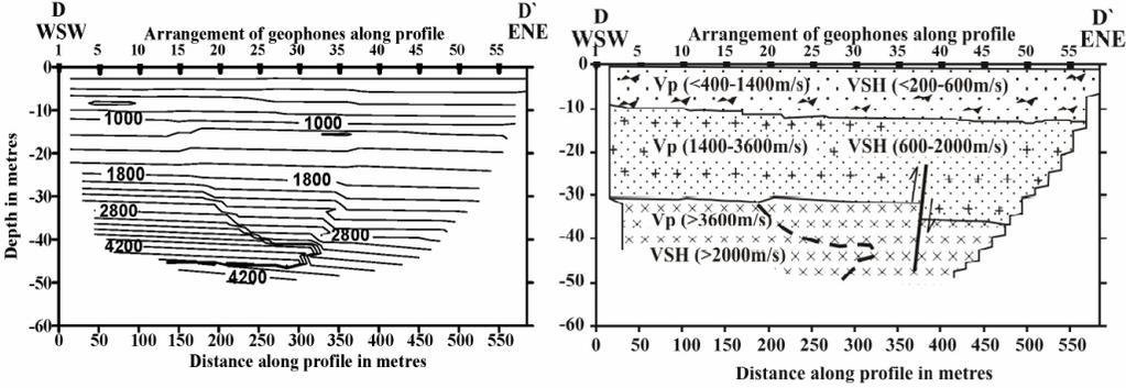


4 Figure 3. 2D SH-wave velocity structures and geoseismic sections for ENE - WSW profiles (El-Haddad, 2008)


5 Figure 4. 2D SH-wave velocity structures and geoseismic sections for NNW-SSE profiles (El-Haddad, 2008)
6 Determining finite elements is a trade-off relation between the numbers of nodes and the slowest shear wave velocity throughout the entire domain. In the present 2D analyses, I used finite elements of the same size throughout the domain with the appropriate node spacing for the slowest SH shear wave velocity. This would be the most stringent option. Generally, the shear wave velocity at Wadi Natash area varies from approximately 4600 m/sec at the 50m depth to less than 200 m/sec at the surface. For simple mesh generation, EasyMesh code program is used as a 2D mesh generator for triangular finite elements. EasyMesh (Niceno, 2002) code program is a two-dimensional quality mesh generator. It generates two dimensional, unstructured, Delaunay and constrained Delaunay triangulations in general domains. 4. RESULTS AND DISCUSSION The results of the present research work could be classified in three main categories. These categories are classified according to the predominant frequencies of the synthetic input ground motions that are used in the 2D simulations. The results are shown as the maximum spectral accelerations at the surface nodal points along the twelve profiles that cover the whole Wadi Natash area. These maximum spectral accelerations determined at frequencies that are corresponding to their predominant frequencies of the input ground motions. In the following sections, results are shown and discussed in detail. In Figure 5, the locations of the faults in the studied area are shown. These faults are interpreted from the geoseismic sections in Figure 3 and Figure 4. Fault location map in Figure 5 is an important tool in interpreting the trapping behaviour of the seismic SH-waves that will be discussed later in the following sections. Figure 5. Fault location map interpreted from 2D SH-wave velocity structures 4.1. High Frequency Simulations The simulations were conducted using synthesized input ground motions with predominant frequencies 11Hz, 15Hz, and 25Hz. As shown in Figure 6(a), slight amplification could be detected in the central and eastern parts of the studied area. In Figure 6(b), there is no significant amplification could be observed in the studied area, except in the northern borders of the studied area. Limited amplification is resulted in the western south part of the studied area, as shown in Figure 6(c). As a result, trapping efficiency due to complex fault structures in the studied area could not be reproduced obviously in this high frequency band.
 input motions 4.2. Medium Frequency Simulations The simulations were conducted using synthesized input ground motions with predominant frequencies 6Hz,")
7 Figure 6. Maximum spectral acceleration at surface using 11Hz (a), 15Hz (b), and 25Hz (c) input motions 4.2. Medium Frequency Simulations The simulations were conducted using synthesized input ground motions with predominant frequencies 6Hz, 8.5Hz and 9.6Hz. As shown in Figure 7(a, b and c), high amplification occupies the entire east northern and western parts of the studied area, whereas slight amplification is resulted in the central area. This high amplification means that seismic waves of frequency band ranging from 6Hz ~ 9.6Hz could trap seismic waves efficiently within fault structures. Therefore, trapping efficiency of seismic waves within the faulted-basin-like structure at the east northern parts of Wadi Natash area could be described as highly positive trapping behaviour or amplification trapping behaviour. Obvious regression in the high amplification peaks that are locating in the central parts of the studied area could be related that complex fault structures in Wadi Natash area could not reproduce the amplification of SH-waves Low Frequency Simulations The simulations were conducted using synthesized input ground motions with predominant frequencies 0.4Hz, 0.6Hz and 2Hz. High deamplification is dominated at the center of the studied area, as shown in Figure 8(a, b and c). This high deamplification means that long period seismic waves could not propagate efficiently in fault structures. Therefore, trapping efficiency of seismic waves within the faulted-basin-like structure at the center of Wadi Natash area could be described as negative trapping behaviour or deamplification trapping behaviour.
 input motions Figure 8. Maximum spectral acceleration at surface using 0.4Hz (a), 0.")
8 Figure 7. Maximum spectral acceleration at surface using 6Hz (a), 8.5Hz (b), and 9.6Hz (c) input motions Figure 8. Maximum spectral acceleration at surface using 0.4Hz (a), 0.6Hz, and 2Hz (c) input motions
9 5. CONCLUSIONS In the present study, 2D finite element simulations have been carried out along twelve profiles at Wadi Natash area. Wadi Natash area is located in the Eastern Desert of Egypt. This area is characterized by significant linear heterogeneities in the subsurface sequence resulted from the presence of structural discontinuities represented by steeply dipping normal and reverse faults affecting both the massive basement and the overlying rocks. Nine synthetic seismograms with different predominant frequencies ranging from 0.4Hz to 25Hz were used as input ground motions at 50m depth. The resulted 2D simulations using synthetic input ground motions with predominant frequencies ranging from 6Hz to 9.6Hz could produce high amplification in the east northern and western parts of Wadi Natash area due to the trapping efficiency. The resulted 2D simulations using synthetic input ground motions with predominant frequencies ranging from 0.4Hz to 2Hz and greater than 9.6Hz could not produce guided wave energy in the overlying fault zone layers. As a result, poorly trapping efficiency is dominated in the center of Wadi Natash area when using synthetic input ground motions with predominant frequencies ranging from 0.4Hz to 2Hz and greater than 9.6Hz. The discussed 2D simulations indicate that the material discontinuities of the fault zone affect significantly the trapping efficiency within a specified band of predominant frequencies of synthetic seismograms, that could be related to fault zone width and fault zone narrowing with depth. AKCNOWLEDGEMENT I deeply acknowledge Prof. Assem El-Sayed El-Haddad (Geology Dept., Science Faculty, Assiut University, Assiut, Egypt) for providing valuable data of detailed 2D SH-wave velocity structures and interpreted geoseismic sections at Wadi Natash area. REFERENCES Ben-Zion, Y. (1998). Properties of Seismic Fault Zone Waves and their Utility for Imaging Low Velocity Structures. J. Geophys. Res. 103, Ben-Zion, Y., Peng, Z., Okaya, D., Seeber, L., Armbruster, J. G., Ozer, N., Michael, A. J., Baris, S., Aktar, M. (2003). A Shallow Fault Zone Structure Illuminated by Trapped Waves in the Karadere- Duzce Branch of the North Anatolian Fault, Western Turkey. Geophys. J. Int. 152: Boore, D. M. (2005). SMSIM- Fortran Programs for Simulating Ground Motions from Earthquakes (Version 2.3). U.S. Geological Survey-Open File Report, A, EGPC, and CONOCO, (1987). Geological Map of Egypt (Scale 1:500,000). Cairo, Egypt. El-Haddad, A.E. (2008). Detection of Ground Water Level in Fractured Basement Using Seismic Velocity Measurements in Wadi Hafafit Area, Eastern Desert, Egypt. J. Appl. Geophys., 7(1), Hashad, M.H. (1994). Geochemical Characteristics and Petrogenesis of Phonolitic Plugs Associated With Wadi Natash Volcanic Rocks. M.E.R.C. Ain Shams University-Earth Science. 8, Hudson, M., Idriss, I. M., Beikae, M. (1994). QUAD4M- A Computer Program to Evaluate The Seismic Response of Soil Structures Using Finite Element Procedures and Incorporating a Compliant Base. National Science Foundation, Washington, D. C., Madani, A. A. (2000). Geological Studies and Remote Sensing Application on Wadi Natash Volcanics, Eastern Desert of Egypt. M.Sc. Thesis, Faculty of Science, Cairo University, Egypt. Michael, A. J. and Ben-Zion, Y. (1998). Inverting Fault Zone Trapped Waves with a Genetic Algorithm. EOS Trans. Am. Geophys. Union, 79, F584. Niceno, B. (2002). EasyMesh- A Two-Dimensional Quality Mesh Generator (Version 1.4). Trieste University, Italy.
SELECTION OF THE OPTIMUM LANDSAT THEMATIC MAPPER BANDS FOR AUTOMATIC LINEAMENTS EXTRACTION, WADI NATASH AREA, SOUTH EASTERN DESERT, EGYPT
 SELECTION OF THE OPTIMUM LANDSAT THEMATIC MAPPER BANDS FOR AUTOMATIC LINEAMENTS EXTRACTION, WADI NATASH AREA, SOUTH EASTERN DESERT, EGYPT Ahmed A. Madani Assistant Professor - Cairo University, Faculty
Guided Waves from Sources Outside Faults: An Indication for Shallow Fault Zone Structure?
 Pure appl. geophys. 161 (2004) 2125 2137 0033 4553/04/122125 13 DOI 10.1007/s00024-004-2553-y Ó Birkhäuser Verlag, Basel, 2004 Pure and Applied Geophysics Guided Waves from Sources Outside Faults: An Indication
High Resolution Imaging of Fault Zone Properties
 Annual Report on 1998-99 Studies, Southern California Earthquake Center High Resolution Imaging of Fault Zone Properties Yehuda Ben-Zion Department of Earth Sciences, University of Southern California
Using trapped waves for mapping shallow fault zones
 Near Surface Geophysics, 2005, 93-99 Using trapped waves for mapping shallow fault zones V. Shtivelman 1, S. Marco 2, M. Reshef 2,. gnon 3 and Y.Hamiel 3,4 1 The Geophysical Institute of Israel, P.O.ox
Effects of Surface Geology on Seismic Motion
 4 th IASPEI / IAEE International Symposium: Effects of Surface Geology on Seismic Motion August 23 26, 2011 University of California Santa Barbara VELOCITY STRUCTURE INVERSIONS FROM HORIZONTAL TO VERTICAL
Three-dimensional calculations of fault-zone-guided waves in various irregular structures
 Geophys. J. Int. (2002) 151, 416 426 Three-dimensional calculations of fault-zone-guided waves in various irregular structures Gunnar Jahnke, 1 Heiner Igel 1 and Yehuda Ben-Zion 2 1 Department für Geound
Horizontal gradient and band-pass filter of aeromagnetic data image the subsurface structure; Example from Esh El Mellaha Area, Gulf of Suez, Egypt.
 Horizontal gradient and band-pass filter of aeromagnetic data image the subsurface structure; Example from Esh El Mellaha Area, Gulf of Suez, Egypt. Essam Aboud 1, Serguei Goussev 2, Hassan Hassan 2, Suparno
Arthur Frankel, William Stephenson, David Carver, Jack Odum, Robert Williams, and Susan Rhea U.S. Geological Survey
 Probabilistic Seismic Hazard Maps for Seattle: 3D Sedimentary Basin Effects, Nonlinear Site Response, and Uncertainties from Random Velocity Variations Arthur Frankel, William Stephenson, David Carver,
Scenario Earthquake Shaking Maps in Japan
 1 Scenario Earthquake Shaking Maps in Japan Nobuyuki Morikawa National Research Institute for Earth Science and Disaster Prevention (NIED), JAPAN Scenario Earthquake Shaking Maps (SESMs) The shaking maps
Structural Style and Tectonic Evolution of the Nakhon Basin, Gulf of Thailand
 Structural Style and Tectonic Evolution of the Nakhon Basin, Gulf of Thailand Piyaphong Chenrai Petroleum Geoscience Program, Department of Geology, Faculty of Science, Chulalongkorn University, Bangkok
Answers: Internal Processes and Structures (Isostasy)
") Answers: Internal Processes and Structures (Isostasy) 1. Analyse the adjustment of the crust to changes in loads associated with volcanism, mountain building, erosion, and glaciation by using the concept
Answers: Internal Processes and Structures (Isostasy) 1. Analyse the adjustment of the crust to changes in loads associated with volcanism, mountain building, erosion, and glaciation by using the concept
SURFACE WAVE MODELLING USING SEISMIC GROUND RESPONSE ANALYSIS
 43 SURFACE WAVE MODELLING USING SEISMIC GROUND RESPONSE ANALYSIS E John MARSH And Tam J LARKIN SUMMARY This paper presents a study of surface wave characteristics using a two dimensional nonlinear seismic
Zhigang Peng. Curriculum Vitae. School of Earth and Atmospheric Sciences Phone: Georgia Institute of Technology Fax:
 Zhigang Peng Curriculum Vitae School of Earth and Atmospheric Sciences Phone: 404-894-0231 Georgia Institute of Technology Fax: 404-894-5638 Office: ES&T Building, Rm. 2256 Email: zhigang.peng@eas.gatech.edu
Instantaneous Spectral Analysis Applied to Reservoir Imaging and Producibility Characterization
 Instantaneous Spectral Analysis Applied to Reservoir Imaging and Producibility Characterization Feng Shen 1* and Gary C. Robinson 1, Tao jiang 2 1 EP Tech, Centennial, CO, 80112, 2 PetroChina Oil Company,
7 Ground Motion Models
 7 Ground Motion Models 7.1 Introduction Ground motion equations are often called attenution relations but they describe much more than just the attenutation of the ground motion; they describe the probability
BROADBAND STRONG MOTION SIMULATION OF THE 2004 NIIGATA- KEN CHUETSU EARTHQUAKE: SOURCE AND SITE EFFECTS
 Third International Symposium on the Effects of Surface Geology on Seismic Motion Grenoble, France, 30 August - 1 September 2006 Paper Number: 105 BROADBAND STRONG MOTION SIMULATION OF THE 2004 NIIGATA-
Blocks Module Content Guide
 Blocks Module Content Guide This guide covers the basics of the content within the Interactive 3D Geologic Blocks Module. The content guide is intended to assist you, the teacher, in creating effective
Seismic Response of Sedimentary Basin Subjected to Obliquely Incident SH Waves
 6 th International Conference on Earthquake Geotechnical Engineering 1-4 November 215 Christchurch, New Zealand Seismic Response of Sedimentary Basin Subjected to Obliquely Incident SH Waves C. B. Zhu
ACCOUNTING FOR SITE EFFECTS IN PROBABILISTIC SEISMIC HAZARD ANALYSIS: OVERVIEW OF THE SCEC PHASE III REPORT
 ACCOUNTING FOR SITE EFFECTS IN PROBABILISTIC SEISMIC HAZARD ANALYSIS: OVERVIEW OF THE SCEC PHASE III REPORT Edward H FIELD 1 And SCEC PHASE III WORKING GROUP 2 SUMMARY Probabilistic seismic hazard analysis
Ministry of Oil and Minerals Petroleum Exploration & Production Authority BLOCK 85 (Al Uqlah North)
") Ministry of Oil and Minerals Petroleum Exploration & Production Authority BLOCK 85 (Al Uqlah North) The Al Uqlah North Block (85) occupies an area of 597 km 2 in the Sabatayn Basin in the province of Shabwah
Ministry of Oil and Minerals Petroleum Exploration & Production Authority BLOCK 85 (Al Uqlah North) The Al Uqlah North Block (85) occupies an area of 597 km 2 in the Sabatayn Basin in the province of Shabwah
SUPPLEMENTARY INFORMATION
 SUPPLEMENTARY INFORMATION doi: 10.1038/ngeo739 Supplementary Information to variability and distributed deformation in the Marmara Sea fault system Tobias Hergert 1 and Oliver Heidbach 1,* 1 Geophysical
Long-period Ground Motion Characteristics of the Osaka Sedimentary Basin during the 2011 Great Tohoku Earthquake
 Long-period Ground Motion Characteristics of the Osaka Sedimentary Basin during the 2011 Great Tohoku Earthquake K. Sato, K. Asano & T. Iwata Disaster Prevention Research Institute, Kyoto University, Japan
Ministry of Oil and Minerals Petroleum Exploration & Production Authority BLOCK 6 (Iryam)
") Ministry of Oil and Minerals Petroleum Exploration & Production Authority BLOCK 6 (Iryam) The Iryam Block (6) occupies an area of 3,911 km 2 in the Sabatayn Basin in the province of Shabwah in central
Ministry of Oil and Minerals Petroleum Exploration & Production Authority BLOCK 6 (Iryam) The Iryam Block (6) occupies an area of 3,911 km 2 in the Sabatayn Basin in the province of Shabwah in central
Topographic effects on the seismic responses of slopes
 Topographic effects on the seismic responses of slopes A. Messaoudi Ecole Polytechnique d Architecture et d Urbanisme (EPAU), El Harrach, Algeria N. Laouami & N. Mezouer National Earthquake Engineering
SAND DISTRIBUTION AND RESERVOIR CHARACTERISTICS NORTH JAMJUREE FIELD, PATTANI BASIN, GULF OF THAILAND
 SAND DISTRIBUTION AND RESERVOIR CHARACTERISTICS NORTH JAMJUREE FIELD, PATTANI BASIN, GULF OF THAILAND Benjawan KIinkaew Petroleum Geoscience Program, Department of Geology, Faculty of Science, Chulalongkorn
Seismic stratigraphy, some examples from Indian Ocean, interpretation of reflection data in interactive mode
 Seismic stratigraphy, some examples from Indian Ocean, interpretation of reflection data in interactive mode K. S. Krishna National Institute of Oceanography, Dona Paula, Goa-403 004. krishna@nio.org Seismic
Seismic Reflection Imaging across the Johnson Ranch, Valley County, Idaho
 Seismic Reflection Imaging across the Johnson Ranch, Valley County, Idaho Report Prepared for the Skyline Corporation Lee M. Liberty Center for Geophysical Investigation of the Shallow Subsurface (CGISS)
Inversion of equivalent linear soil parameters during the Tohoku, 2011 Tohoku Japan Earthquake, Japan
 Inversion of equivalent linear soil parameters during the Tohoku, 2011 Tohoku Japan Earthquake, Japan F. De Martin, H. Kawase, F. Bonilla, S. Matsushima F. De Martin Brgm (French Geological Survey), Orleans,
Microtremor survey methods in the Tamar Valley, Launceston, Tasmania: Evidence of 2D resonance from microtremor observations.
 Microtremor survey methods in the Tamar Valley, Launceston, Tasmania: Evidence of 2D resonance from microtremor observations. Maxime Claprood 1, Michael W. Asten 2 1. Corresponding author. PhD candidate,
Effects of Surface Geology on Seismic Motion
 4 th IASPEI / IAEE International Symposium: Effects of Surface Geology on Seismic Motion August 23 26, 2011 University of California Santa Barbara EFFECTS OF TOPOGRAPHIC POSITION AND GEOLOGY ON SHAKING
Low-velocity damaged structure of the San Andreas Fault at Parkfield from fault zone trapped waves
 GEOPHYSICAL RESEARCH LETTERS, VOL. 31, L12S06, doi:10.1029/2003gl019044, 2004 Low-velocity damaged structure of the San Andreas Fault at Parkfield from fault zone trapped waves Yong-Gang Li Department
Optimizing Geophysical Inversions for Archean Orogenic Gold Settings
 Geophysical Inversion and Modeling Optimizing Geophysical Inversions for Archean Orogenic Gold Settings 1. University of British Columbia Paper 103 Mitchinson, D. E. [1], Phillips, N. D. [1] ABSTRACT Geophysical
Imaging sharp lateral velocity gradients using scattered waves on dense arrays: faults and basin edges
 2017 SCEC Proposal Report #17133 Imaging sharp lateral velocity gradients using scattered waves on dense arrays: faults and basin edges Principal Investigator Zhongwen Zhan Seismological Laboratory, California
An empirical method for estimation of anisotropic parameters in clastic rocks
 An empirical method for estimation of anisotropic parameters in clastic rocks YONGYI LI, Paradigm Geophysical, Calgary, Alberta, Canada Clastic sediments, particularly shale, exhibit transverse isotropic
Exploring Site Response in the Taipei Basin with 2D and 3D Numerical Simulations
 Exploring Site Response in the Taipei Basin with 2D and 3D Numerical Simulations J. Miksat1, K.-L. Wen2, Ch.-T. Chen.2, V. Sokolov1 and F. Wenzel1 1 Geophysical Institute, Karlsruhe University, Hertzstr.
11th Biennial International Conference & Exposition. Keywords Sub-basalt imaging, Staggered grid; Elastic finite-difference, Full-waveform modeling.
 Sub-basalt imaging using full-wave elastic finite-difference modeling: A synthetic study in the Deccan basalt covered region of India. Karabi Talukdar* and Laxmidhar Behera, CSIR-National Geophysical Research
Determination of uplift rates of fluvial terraces across the Siwaliks Hills, Himalayas of central Nepal
 Determination of uplift rates of fluvial terraces across the Siwaliks Hills, Himalayas of central Nepal Martina Böhme Institute of Geology, University of Mining and Technology, Freiberg, Germany Abstract.
Complex Site Response: Does One-Dimensional Site Response Work?
 : Does One-Dimensional Site Response Work? ESG4 UCSB August 23-26,2011 Laurie G. Baise Department of Civil & Environmental Engineering, Tufts University August 25, 2011 Collaborators and Acknowledgements
Name: Date: Use the following to answer question 2.
 Name: Date: 1. Which of the following statements regarding the scientific method is false? A) A hypothesis must be agreed upon by more than one scientist. B) A theory is a hypothesis that has withstood
Southern California ground motion envelopes over ranges of magnitudes, distances, and site conditions
 55 Chapter 3 Average properties of Southern California ground motion envelopes over ranges of magnitudes, distances, and site conditions In this chapter, I use the envelope attenuation relationships derived
Groundwater Sustainability at Wadi Al Bih Dam, Ras El Khaimah, United Arab Emirates (UAE) using Geophysical methods
 using Geophysical methods") Groundwater Sustainability at Wadi Al Bih Dam, Ras El Khaimah, United Arab Emirates (UAE) using Geophysical methods Ahmed Murad, Amir Gabr, Saber Mahmoud, Hasan Arman & Abdulla Al Dhuhoori Geology Department
Groundwater Sustainability at Wadi Al Bih Dam, Ras El Khaimah, United Arab Emirates (UAE) using Geophysical methods Ahmed Murad, Amir Gabr, Saber Mahmoud, Hasan Arman & Abdulla Al Dhuhoori Geology Department
Investigation of long period amplifications in the Greater Bangkok basin by microtremor observations
 Proceedings of the Tenth Pacific Conference on Earthquake Engineering Building an Earthquake-Resilient Pacific 6-8 November 2015, Sydney, Australia Investigation of long period amplifications in the Greater
Micro Seismic Hazard Analysis
 Micro Seismic Hazard Analysis Mark van der Meijde INTERNATIONAL INSTITUTE FOR GEO-INFORMATION SCIENCE AND EARTH OBSERVATION Overview Site effects Soft ground effect Topographic effect Liquefaction Methods
RISKY HIGH-RISE BUILDINGS RESONATING WITH THE LONG-PERIOD STRONG GROUND MOTIONS IN THE OSAKA BASIN, JAPAN
 RISKY HIGH-RISE BUILDINGS RESONATING WITH THE LONG-PERIOD STRONG GROUND MOTIONS IN THE OSAKA BASIN, JAPAN K. Miyakoshi 1 and M. Horike 2 ABSTRACT : 1 Earthquake Engineering Group, Geo-Research Institute,
Effects of Surface Geology on Seismic Motion
 4 th IASPEI / IAEE International Symposium: Effects of Surface Geology on Seismic Motion August 23 26, 2011 University of California Santa Barbara PERIOD-DEPENDENT SITE AMPLIFICATION FOR THE 2008 IWATE-MIYAGI
ANALYTICAL STUDY ON RELIABILITY OF SEISMIC SITE-SPECIFIC CHARACTERISTICS ESTIMATED FROM MICROTREMOR MEASUREMENTS
 ANALYTICAL STUDY ON RELIABILITY OF SEISMIC SITE-SPECIFIC CHARACTERISTICS ESTIMATED FROM MICROTREMOR MEASUREMENTS Boming ZHAO 1, Masanori HORIKE 2 And Yoshihiro TAKEUCHI 3 SUMMARY We have examined the site
Topography on Earthquake Motions in Sedimentary Basins
 TRANSPORTATION RESEARCH RECORD 1411 Effects of Three-Dimensional Bedrock Topography on Earthquake Motions in Sedimentary Basins ARTHUR FRANKEL Work being done at the U.S. Geological Survey on 3-D simulations
Estimation of Peak Ground Acceleration for Delhi Region using Finsim, a Finite Fault Simulation Technique
 215 Estimation of Peak Ground Acceleration for Delhi Region using Finsim, a Finite Fault Simulation Technique NEELIMA SATYAM. D* and K. S. RAO** * Earthquake Engineering Research Centre, International
Synthetic Seismogram A Tool to Calibrate PP & PS Seismic Data
 P-475 Summary Synthetic Seismogram A Tool to Calibrate PP & PS Seismic P. Sugadha*, M. K. Jain, M. Singh, ONGC Conventional P wave technology will not meet all the requirements of the industry. Hence,
Japan Seismic Hazard Information Station
 Japan Seismic Hazard Information Station (J-SHIS) Hiroyuki Fujiwara National Research Institute for Earth Science and Disaster Prevention (NIED) Background of the Project Headquarters for Earthquake Research
By D.H. Lang 1 and J. Schwarz 1. This paper is an extract from
 Identification of the Subsoil Profile Characteristics at the Coyote Creek Outdoor Classroom (CCOC), San José, from Microtremor Measurements - A Contribution to the CCOC Blind Comparison Experiment By D.H.
Analysis Of Earthquake Records of Istanbul Earthquake Rapid Response System Stations Related to the Determination of Site Fundamental Frequency
 Analysis Of Earthquake Records of Istanbul Earthquake Rapid Response System Stations Related to the Determination of Site Fundamental Frequency A. C. Zulfikar, H. Alcik & E. Cakti Bogazici University,Kandilli
Mine Scale Constrained Geophysical Inversion; A Case Study at the Darlot-Centenary Gold Mine
 Page 1 Mine Scale Constrained Geophysical Inversion; A Case Study at the Darlot-Centenary Gold Mine Sarah Monoury, SRK Consulting, Ben Jupp, SRK Consulting and Andrew Foley, Gold Fields This article was
Soils, Hydrogeology, and Aquifer Properties. Philip B. Bedient 2006 Rice University
 Soils, Hydrogeology, and Aquifer Properties Philip B. Bedient 2006 Rice University Charbeneau, 2000. Basin Hydrologic Cycle Global Water Supply Distribution 3% of earth s water is fresh - 97% oceans 1%
Effects of Surface Geology on Seismic Motion
 4 th IASPEI / IAEE International Symposium: Effects of Surface Geology on Seismic Motion August 23 26, 2011 University of California Santa Barbara A STUDY ON THE ESTIMATION METHOD FOR UNDERGROUND STRUCTURE
PEAK GROUND HORIZONTAL ACCELERATION ATTENUATION RELATIONSHIP FOR LOW MAGNITUDES AT SHORT DISTANCES IN SOUTH INDIAN REGION
 PEAK GROUND HORIZONTAL ACCELERATION ATTENUATION RELATIONSHIP FOR LOW MAGNITUDES AT SHORT DISTANCES IN SOUTH INDIAN REGION C.Srinivasan 1, M.L.Sharma 2, J. Kotadia 2 and Y.A.Willy 1 1. National Institute
3D Geometry of the Xade Complex inferred from Gravity and Magnetic Data
 Geophysical Case Histories 3D Geometry of the Xade Complex inferred from Gravity and Magnetic Data 1. British Geological Survey, Edinburgh, United Kingdom Paper 92 Pouliquen, G. [1], Key, R. [1] ABSTRACT
Geomorphology Final Exam Study Guide
 Geomorphology Final Exam Study Guide Geologic Structures STRUCTURAL GEOLOGY concerned with shapes, arrangement, interrelationships of bedrock units & endogenic (within) forces that cause them. Tectonic
Bulletin of Earth Sciences of Thailand. Evaluation of the Petroleum Systems in the Lanta-Similan Area, Northern Pattani Basin, Gulf of Thailand
 Evaluation of the Petroleum Systems in the Lanta-Similan Area, Northern Pattani Basin, Gulf of Thailand Sirajum Munira Petroleum Geoscience Program, Department of Geology, Faculty of Science, Chulalongkorn
EVALUATION OF AQUIFER CHARACTERISTICS FOR SELECTED NEW METHOD OF THE UM RUWABA FORMATION: NORTH KORDOFAN STATE, SUDAN
 EVALUATION OF AQUIFER CHARACTERISTICS FOR SELECTED NEW METHOD OF THE UM RUWABA FORMATION: NORTH KORDOFAN STATE, SUDAN ELHAGA.B *1; ELZIENS.M*2 ANDLISSANN.H*3 *1Department of C i v i l E n g i n e e r i
On the Horizontal-to-Vertical Spectral Ratio in Sedimentary Basins
 Bulletin of the Seismological Society of America, 90, 4, pp. 1101 1106, August 2000 On the Horizontal-to-Vertical Spectral Ratio in Sedimentary Basins by Zakaria Al Yuncha and Francisco Luzón Abstract
STUDY ON MICROTREMOR CHARACTERISTICS BASED ON SIMULTANEOUS MEASUREMENTS BETWEEN BASEMENT AND SURFACE USING BOREHOLE
 STUDY ON MICROTREMOR CHARACTERISTICS BASED ON SIMULTANEOUS MEASUREMENTS BETWEEN BASEMENT AND SURFACE USING BOREHOLE Takahisa ENOMOTO 1, Toshio KURIYAMA 2, Norio ABEKI 3, Takahiro IWATATE 4, Manuel NAVARRO
Seismic Velocity Measurements at Expanded Seismic Network Sites
 UK/KRCEE Doc #: P8.3 2005 Seismic Velocity Measurements at Expanded Seismic Network Sites Prepared by Kentucky Research Consortium for Energy and Environment 233 Mining and Minerals Building University
Earthquake patterns in the Flinders Ranges - Temporary network , preliminary results
 Earthquake patterns in the Flinders Ranges - Temporary network 2003-2006, preliminary results Objectives David Love 1, Phil Cummins 2, Natalie Balfour 3 1 Primary Industries and Resources South Australia
Empirical Green s Function Analysis of the Wells, Nevada, Earthquake Source
 Nevada Bureau of Mines and Geology Special Publication 36 Empirical Green s Function Analysis of the Wells, Nevada, Earthquake Source by Mendoza, C. 1 and Hartzell S. 2 1 Centro de Geociencias, Universidad
Chapter 1. Introduction EARTH MODEL BUILDING
 Chapter 1 Introduction Seismic anisotropy in complex earth subsurface has become increasingly important in seismic imaging due to the increasing offset and azimuth in modern seismic data. To account for
Characterisation of late Quaternary displacements on the Waitangi Fault at Aviemore Dam, New Zealand
 Characterisation of late Quaternary displacements on the Waitangi Fault at Aviemore Dam, New Zealand D.J.A. Barrell, R.J. Van Dissen, K.R. Berryman, & S.A.L. Read Institute of Geological & Nuclear Sciences
Ministry of Oil and Minerals Petroleum Exploration & Production Authority BLOCK 80 (WADI SARR)
") Ministry of Oil and Minerals Petroleum Exploration & Production Authority BLOCK 80 (WADI SARR) The Wadi Sarr Block (80) occupies an area of 1961 km 2 on the Sayun- Masilah Basin in the central Yemen. Block
Ministry of Oil and Minerals Petroleum Exploration & Production Authority BLOCK 80 (WADI SARR) The Wadi Sarr Block (80) occupies an area of 1961 km 2 on the Sayun- Masilah Basin in the central Yemen. Block
Assignment #5-7: Geology
 Assignment #5-7: Geology Name: 1. "Geological processes operating at the present time are the same processes that have operated in the past" is a statement of: A. the Principle of Cross-cutting Relationships
Re-processing of 2D seismic data from Razzak oil field, Western Desert, Egypt
 American Journal of Science and Technology 2015; 2(1): 1-8 Published online November 30, 2014 (http://www.aascit.org/journal/ajst) ISSN: 2375-3846 Re-processing of 2D seismic data from Razzak oil field,
Evaluation of Neocomian Shale source rock In Komombo Basin, Upper Egypt
 Evaluation of Neocomian Shale source rock In Komombo Basin, Upper Egypt Abdelhady, A. 1, Darwish, M. 2, El Araby, A. 3 and Hassouba, A. 4 1 DEA Egypt, Cairo, Egypt 2 Geology Department, Faculty of Science,
Available online Journal of Scientific and Engineering Research, 2016, 3(2):1-7. Research Article
:1-7. Research Article") Available online www.jsaer.com, 2016, 3(2):1-7 Research Article ISSN: 2394-2630 CODEN(USA): JSERBR Assessment of the Reliability of Magnetic Method to Delineate Geologic Features in a Basement Complex:
Available online www.jsaer.com, 2016, 3(2):1-7 Research Article ISSN: 2394-2630 CODEN(USA): JSERBR Assessment of the Reliability of Magnetic Method to Delineate Geologic Features in a Basement Complex:
Numerical simulation of fault zone guided waves: accuracy and 3-D effects
 1 Numerical simulation of fault zone guided waves: accuracy and 3-D effects Heiner Igel 1, Gunnar Jahnke 1, Yehuda Ben-Zion 2 Abstract Fault zones are thought to consist of regions with reduced seismic
NUMERICAL SIMULATION OF STRONG GROUND MOTION ON ADAPAZARI BASIN DURING THE 1999 KOCAELI, TURKEY, EARTHQUAKE
 13 th World Conference on Earthquake Engineering Vancouver, B.C., Canada August 1-6, 2004 Paper No. 720 NUMERICAL SIMULATION OF STRONG GROUND MOTION ON ADAPAZARI BASIN DURING THE 1999 KOCAELI, TURKEY,
A) B) C) D) 4. Which diagram below best represents the pattern of magnetic orientation in the seafloor on the west (left) side of the ocean ridge?
 B) C) D) 4. Which diagram below best represents the pattern of magnetic orientation in the seafloor on the west (left) side of the ocean ridge?") 1. Crustal formation, which may cause the widening of an ocean, is most likely occurring at the boundary between the A) African Plate and the Eurasian Plate B) Pacific Plate and the Philippine Plate C)
1. Crustal formation, which may cause the widening of an ocean, is most likely occurring at the boundary between the A) African Plate and the Eurasian Plate B) Pacific Plate and the Philippine Plate C)
Tu D Understanding the Interplay of Fractures, Stresses & Facies in Unconventional Reservoirs - Case Study from Chad Granites
 Tu D201 04 Understanding the Interplay of Fractures, Stresses & Facies in Unconventional Reservoirs - Case Study from Chad Granites D. Lirong (Chinese National Petroleum Company Ltd. (Chad)), C. Shrivastava*
Red Sea Basins. by Prof. Dr. Abbas Mansour
 Red Sea Basins TECTONO-SEDIMENTARY EVOLUTION OF THE NW PARTS OF THE RED SEA The pre-rift rift by Prof. Dr. Abbas Mansour 1.a. The Precambrian basement and the inherited structural pattern of the rift
Page 1. Name:
 Name: Questions 1 through 3 refer to the following: The diagrams below represent two rock outcrops found several miles apart in New York State. Individual rock layers are lettered, and fossils and rock
3D VISCO-ELASTIC WAVE PROPAGATION IN THE BORREGO VALLEY, CALIFORNIA
 3D VISCO-ELASTIC WAVE PROPAGATION IN THE BORREGO VALLEY, CALIFORNIA Kim B OLSEN 1, Robert L NIGBOR 2 And Takaaki KONNO 3 SUMMARY We have simulated 2-Hz wave propagation in a three-dimensional model of
Terrain Units PALEOGEOGRAPHY: LANDFORM CREATION. Present Geology of NYS. Detailed Geologic Map of NYS
 NYS TOPOGRAPHY Why so? PALEOGEOGRAPHY: LANDFORM CREATION Prof. Anthony Grande AFG 014 Present Geology of NYS Detailed Geologic Map of NYS Generalized Geology Detailed Geology Hot links to the fold out
GLY 155 Introduction to Physical Geology, W. Altermann. Press & Siever, compressive forces. Compressive forces cause folding and faulting.
 Press & Siever, 1995 compressive forces Compressive forces cause folding and faulting. faults 1 Uplift is followed by erosion, which creates new horizontal surface. lava flows Volcanic eruptions cover
Report on the evaluation of geophysical data and seismic site effects in the Maltese archipelago in relation to the calculation of seismic risk
 Project Acronym: SIMIT Project Name: Sistema Integrato di Protezione CivileTransfrontalieroItalo-Maltese Project Code: B1-2.19/11 Start Date: March 2013 End Date: September 2015 Work Package 2: Identification
SIMULATION OF NEAR FIELD STRONG GROUND MOTIONS AT TOMBAK SITE IN IRAN USING HYBRID METHOD
 SIMULATION OF NEAR FIELD STRONG GROUND MOTIONS AT TOMBAK SITE IN IRAN USING HYBRID METHOD ABSTRACT : B. Ebrahimian 1, M.S. Sahraeian 2 and As. Noorzad 3 1 Ph.D. Candidate, School of Civil Engineering,
EMPIRICAL SCALING OF STRONG EARTHQUAKE GROUND MOTION - PART II: DURATION OF STRONG MOTION
 ISET Journal of Earthquake Technology, Paper No. 46, Vol. 39, No.4, December, pp. 55-71 EMPIRICAL SCALING OF STRONG EARTHQUAKE GROUND MOTION - PART II: DURATION OF STRONG MOTION V.W. Lee Civil Engineering
Geophysical Exploration of the Western Saudi Arabian Geothermal Province: First Results from the Al-Lith Area
 Proceedings World Geothermal Congress 2015 Melbourne, Australia, 19-25 April 2015 Geophysical Exploration of the Western Saudi Arabian Geothermal Province: First Results from the Al-Lith Area Aref Lashin
SPECTRAL ANALYSIS OF GROUND MAGNETIC DATA IN MAGADI AREA, SOUTHERN KENYA RIFT
 SPECTRAL ANALYSIS OF GROUND MAGNETIC DATA IN MAGADI AREA, SOUTHERN KENYA RIFT 1 JG Githiri, 2 JP Patel, 3 JO Barongo and 4 PK Karanja 1 Jomo-Kenyatta University of Agriculture, Science and Technology,
2C09 Design for seismic and climate changes
 2C09 Design for seismic and climate changes Lecture 10: Characterisation of seismic motion Aurel Stratan, Politehnica University of Timisoara 07/04/2017 European Erasmus Mundus Master Course Sustainable
ONE-DIMENSIONAL RESPONSE OF A BOREHOLE STATION DURING THE 2005 WEST OFF FUKUOKA PREFECTURE EARTHQUAKE: OBSERVATION AND SIMUALTION
 ONE-DIMENSIONAL RESPONSE OF A BOREHOLE STATION DURING THE 2005 WEST OFF FUKUOKA PREFECTURE EARTHQUAKE: OBSERVATION AND SIMUALTION F. De Martin 1, H. Kawase 2 and A. Modaressi 3 1 Engineer, Development
The significance of site effect studies for seismic design and assessment of industrial facilities
 The significance of site effect studies for seismic design and assessment of industrial facilities Corinne Lacave, Martin G. Koller Pierino Lestuzzi, and Christelle Salameh Résonance Ingénieurs-Conseils
For Peer Review. Michael A. Lewis 1,2 and Yehuda Ben-Zion 1
 Page of Diversity of fault zone damage and trapping structures in the Parkfield section of the San Andreas Fault from comprehensive analysis of near fault seismograms Michael A. Lewis, and Yehuda Ben-Zion.
Seismic Inversion on 3D Data of Bassein Field, India
 5th Conference & Exposition on Petroleum Geophysics, Hyderabad-2004, India PP 526-532 Seismic Inversion on 3D Data of Bassein Field, India K.Sridhar, A.A.K.Sundaram, V.B.G.Tilak & Shyam Mohan Institute
New Prediction Formula of Fourier Spectra Based on Separation Method of Source, Path, and Site Effects Applied to the Observed Data in Japan
 New Prediction Formula of Fourier Spectra Based on Separation Method of Source, Path, and Site Effects Applied to the Observed Data in Japan Kenichi Nakano Graduate School of Engineering, Kyoto University,
Knowledge of in-slab earthquakes needed to improve seismic hazard estimates for southwestern British Columbia
 USGS OPEN FILE REPORT #: Intraslab Earthquakes 1 Knowledge of in-slab earthquakes needed to improve seismic hazard estimates for southwestern British Columbia John Adams and Stephen Halchuk Geological
Bulletin of Earth Sciences of Thailand
 Depositional Environments and Stratigraphic Development of the Grand Taman Sari Circuit Outcrop: an Analogue for Transgressive Mahakam Delta Successions Ridha Santika Riadi Petroleum Geoscience Program,
EMPIRICAL EVIDENCE FROM THE NORTHRIDGE EARTHQUAKE FOR SITE- SPECIFIC AMPLIFICATION FACTORS USED IN US BUILDING CODES
 EMPIRICAL EVIDENCE FROM THE NORTHRIDGE EARTHQUAKE FOR SITE- SPECIFIC AMPLIFICATION FACTORS USED IN US BUILDING CODES Roger D BORCHERDT And Thomas E FUMAL SUMMARY Site-specific amplification factors, F
Downloaded 10/10/13 to Redistribution subject to SEG license or copyright; see Terms of Use at
 Characterizing a fault-zone and associated fractures using lab experiments and attribute-based seismic analysis: an example from Woodford Shale, Anadarko basin, Oklahoma Zonghu Liao*, Ze ev Reches, and
Anisotropic anelastic seismic full waveform modeling and inversion: Application to North Sea offset VSP data
 CONFERENCE PROCEEDINGS DOI: https://doi.org/10.18599/grs.2018.3.149-153 Anisotropic anelastic seismic full waveform modeling and inversion: Application to North Sea offset VSP data C. Barnes 1, M. Charara
Principles of Geology
 Principles of Geology Essential Questions What is Uniformitarianism? What is Catastrophism? What is Steno s s Law? What are the other geologic principles? How is relative age determined using these principles?
Updated Graizer-Kalkan GMPEs (GK13) Southwestern U.S. Ground Motion Characterization SSHAC Level 3 Workshop 2 Berkeley, CA October 23, 2013
 Southwestern U.S. Ground Motion Characterization SSHAC Level 3 Workshop 2 Berkeley, CA October 23, 2013") Updated Graizer-Kalkan GMPEs (GK13) Southwestern U.S. Ground Motion Characterization SSHAC Level 3 Workshop 2 Berkeley, CA October 23, 2013 PGA Model Our model is based on representation of attenuation
Updated Graizer-Kalkan GMPEs (GK13) Southwestern U.S. Ground Motion Characterization SSHAC Level 3 Workshop 2 Berkeley, CA October 23, 2013 PGA Model Our model is based on representation of attenuation
Influence of a sedimentary basin infilling description on the 2D P-SV wave propagation using linear and nonlinear constitutive models
 Influence of a sedimentary basin infilling description on the 2D P-SV wave propagation using linear and nonlinear constitutive models C. Gélis IRSN, France L.F. Bonilla Université Paris Est - IFSTTAR,