Application of Automated detection techniques in Magnetic Data for Identification of Cu-Au Porphyries
|
|
|
- Leo Reeves
- 5 years ago
- Views:
Transcription


1 Application of Automated detection techniques in Magnetic Data for Identification of Cu-Au Porphyries August 2010
2 Introduction 1. Background 2. Porphyry MagneticSignatures 3. Filter Theory -Exploration 4. Application Examples 5. Summary. Where to next?
3 Background What? Research agreement between CET and Barrick signed in 2008 to solefund Porphyry Texture Filter Why? Au rich porphyry focus Magnetic coverage available over most projects capitalise investment Rapid objective analysis of large datasets with strong geological context Discrimination within highly magnetic terrains How? Automatically detect and quantify porphyry magnetic signatures via user defined application of porphyry target model and remove the dependency on finding the bump
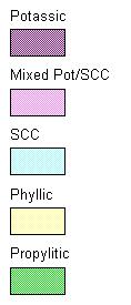
4 Porphyry Idealised Signature Host Lithology Dominant Alteration Dominant Host Lithology Dominant Modified from Clark 1992 Propylitic Potassic Phyllic Phyllic Propylitic


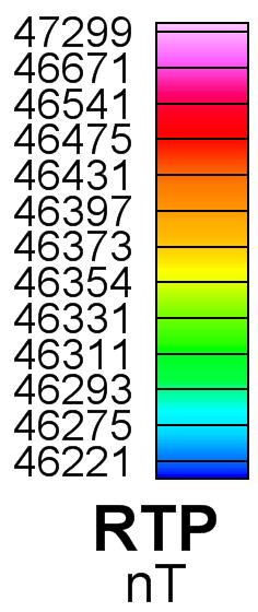
5 Porphyry Idealised Signature Surface Alteration RTP Magnetics H15 H14 500m 500m
6 Theory Basics 1. CIRCULAR FEATURE DETECTION Define radius and shape of target porphyry Enhance target response Suppress non-circular features Output RST grid 2. FEATURE VALIDATION Define expected magnetic contrast Pass features meeting criteria Assign threshold strength and radius to each centre Grid and database product 3. BOUNDARY SPLINES Select appropriate threshold from feature validation Quantify outer edge of alteration dominant zone Polygon file output


7 Theory Simple Example Centre of Symmetry Seed Radius Final Boundary Input RTP Grid Radial Symmetry Magnetic Contrast Magnetic Contrast Contrast Radius Final Product
8 Application Considerations MAGNETIC DATASET Gridded and of appropriate scale Reduced to Pole Inducing Field No need for excellent data quality GEOLOGICAL/TARGET SETTING Structural regime geometry Host lithologies Target characterisation shape, size, contrast Depth of emplacement
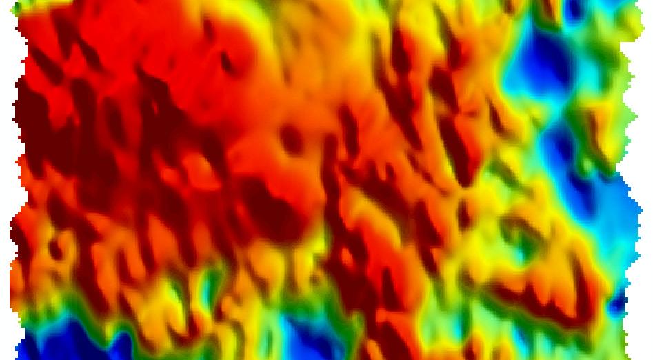
9 Application -Grasberg Grasberg Ertsberg Dom Modified from Meinert et al 1997

10 Application - Grasberg Grasberg Ertsberg Dom RTP Modified from Meinert et al 1997

11 Application - Grasberg Central of radial symmetry Grasberg Ertsberg Dom Analytical Signal Grasberg Ertsberg Radial Symmetry Dom

12 Application - Grasberg Grasberg Ertsberg Dom Final Boundary Output Contrast Enhanced Central of radial symmetry

13 Application -Grasberg Grasberg Ertsberg Dom Geology & Boundaries
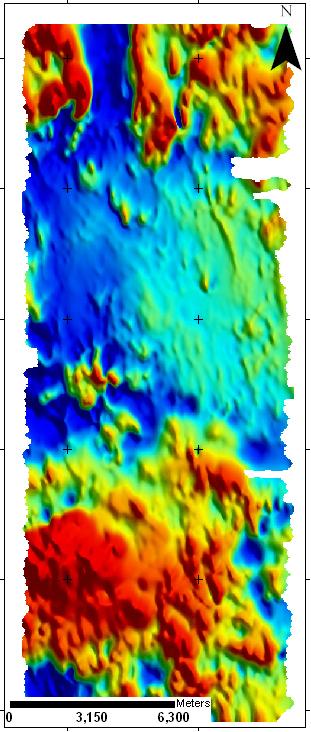
14 Application -Exploration Known Porphyry


15 Application -Exploration Radial Symmetry Magnetic Contrast RTP + Boundaries


16 Application -Exploration Target? Known Porphyry 2km
17 Filter Limitations TARGET CRITERIA REQUIRED Requires some knowledge of geology Existing porphyry in data significant RTP REQUIRED Remanence Low latitudes LEARNING CURVE Familiarisation time required
18 Filter Advantages REJECTS NON-CIRCULAR NOISE Noisy data has reduced impact Differentiate edge gradients SIGNIFICANT USER INPUT Geologically robust Tuned High rate of prediction for known porphyries INTERMEDIATE PRODUCTS Simple analysis on the fly Suite of results
19 Filter Advantages QUANTIFICATION Integration into GIS packages Qualitative and quantitative EASE OF USE Operates in Geosoft environment Fast and objective
20 Conclusions A successful research project which has given an additional layer for porphyry exploration. Actively applied to all Barrick projects with ground truthing demonstrating continued success.
21 Acknowledgements University of Western Australia and the Centre of Exploration Targeting Barrick Gold Technical Group My Family
Simon Crosato, Brendan Howe. capable of producing meaningful results in a variety of target regimes at all scales and geological environments.
 Meeting Geophysical Challenges: Application of automated detection techniques in magnetic data for identification of Cu-Au porphyries in covered or magnetic terrains Matthew Hope, Barry Bourne Simon Crosato,
ASEG Inversion Workshop: Examples of 3D Potential Field inversions Low Latitudes and Remanence
 ASEG Inversion Workshop: Examples of 3D Potential Field inversions Low Latitudes and Remanence B. Bourne, Principal Consultant,, 2 nd September 2014 (bbourne70@gmail.com +61 409493485) 1 Introduction Remanence
Pasco project ground magnetics
 Pasco project ground magnetics Survey information Magnetic results Comments Conclusions General data information 13 June 2017 Piura Trujillo Lima Pasco Cusco Arequipa Survey information General geographic
Geological & Geophysical Interpretation of ZTEM EM and Magnetic Survey. Kemess Project, BC. for AuRico Metals Inc. September, 2016 Nicole Pendrigh
 Geological & Geophysical Interpretation of ZTEM EM and Magnetic Survey Kemess Project, BC for AuRico Metals Inc. September, 2016 Nicole Pendrigh SUMMARY REPORT Regional setting Located in North central
COPPER KING PROPERTY GROUND MAGNETIC SURVEY GIS DATABASE. Ground Magnetic Survey Preliminary Interpretation
 COPPER KING PROPERTY GROUND MAGNETIC SURVEY GIS DATABASE Ground Magnetic Survey Preliminary Interpretation James L. Wright M.Sc. July 18, 2017 TABLE OF CONTENTS INTRODUCTION......................... 2
Use of Geostatistically-constrained Potential Field Inversion and Downhole Drilling to Predict Distribution of Sulphide and Uranium Mineralisation
 Use of Geostatistically-constrained Potential Field Inversion and Downhole Drilling to Predict Distribution of Sulphide and Uranium Mineralisation Matthew Zengerer Talk Outline Introduction Purpose and
Resource Management through Machine Learning
 Resource Management through Machine Learning Justin Granek Eldad Haber* Elliot Holtham University of British Columbia University of British Columbia NEXT Exploration Inc Vancouver, BC V6T 1Z4 Vancouver,
Predictive Modelling of Ag, Au, U, and Hg Ore Deposits in West Texas Carl R. Stockmeyer. December 5, GEO 327G
 Predictive Modelling of Ag, Au, U, and Hg Ore Deposits in West Texas Carl R. Stockmeyer December 5, 2013 - GEO 327G Objectives and Motivations The goal of this project is to use ArcGIS to create models
COMMANDER RESOURCES LTD.
 COMMANDER RESOURCES LTD. October Dome Gold Skarn Mt Polley Core Facility February 2016 1 August 2016 CORPORATE DISCLOSURE Disclaimer The information contained herein, while obtained from sources which
CORPORATE PROFILE Airborne Geophysics for Mineral Exploration
 CORPORATE PROFILE Airborne Geophysics for Mineral Exploration Highlights Specialists in high resolution airborne geophysical surveys in mountainous terrain Precision GeoSurveys is a full-service airborne
USE OF RADIOMETRICS IN SOIL SURVEY
 USE OF RADIOMETRICS IN SOIL SURVEY Brian Tunstall 2003 Abstract The objectives and requirements with soil mapping are summarised. The capacities for different methods to address these objectives and requirements
JOSH LEIGH Project Exploration Geologist June ASX Code AIV
 COALSTOUN AND BOOUBYJAN Porphyry Copper-Gold Complexes, their structural setting, geology and geochemistry Joshua Leigh 1, Doug Young 2, Jose Veracruz 3, Paul Ashley 3 - ( 1 ActivEX Limited, 2 Consultant,
The Geophysics of Cu-Au Porphyry Systems
 The Geophysics of Cu-Au Porphyry Systems Batu Hijau Elang Grasberg Wafi-Golpu Terry Hoschke Palembang November 2015 terry.hoschke@gmail.com Physical Properties Magnetic Properties Remanent Magnetism Magnetic
Titiribi Gold: Sleeping Giant in the Colombian Cordilleras (a Geophysical Study)
") Titiribi Gold: Sleeping Giant in the Colombian Cordilleras (a Geophysical Study) Emmett Van Reed, P.Gp. Zonge Engineering & Research Amit Tripathi, Ph.D. Terra Resources Development Technologies Jennifer
Titiribi Gold: Sleeping Giant in the Colombian Cordilleras (a Geophysical Study) Emmett Van Reed, P.Gp. Zonge Engineering & Research Amit Tripathi, Ph.D. Terra Resources Development Technologies Jennifer
C5 Magnetic exploration methods data analysis techniques
 C5 Magnetic exploration methods data analysis techniques C5.1 Data processing and corrections After magnetic field data have been collected a number of corrections are applied to simplify the interpretation.
Reduction to the Pole of Magnetic Anomalies Using Analytic Signal. A.H. Ansari and K. Alamdar
 World Applied Sciences Journal 7 (4): 405-409, 2009 SSN 1818-4952 DOS Publications, 2009 Reduction to the Pole of Magnetic Anomalies Using Analytic Signal A.H. Ansari K. Alamdar Department of Mining Metallurgical
Man, Machine and Data: A Mineral Exploration Perspective
 Man, Machine and Data: A Mineral Exploration Perspective Eun-Jung Holden, Geodata Algorithms Team The Centre for Exploration Targeting, School of Earth Sciences The University of Western Australia Team
Ramping-up Exploration Value from Aeromagnetic Surveys - More Geological Input Needed!
 Ramping-up Exploration Value from Aeromagnetic Surveys - More Geological Input Needed! Dave Isles Southern Geoscience Consultants AIG Geoscientists Symposia Bali May 2013 EAST ASIA: Geology, Exploration
Magnetic and Gravity Methods for Geothermal Exploration
 Magnetic and Gravity Methods for Geothermal Exploration Dr. Hendra Grandis Geophysics - ITB method and survey procedure Aero- or ground magnetic (covers a large area) Schlumberger resistivity mapping and
For personal use only
 20 16 FEBRUARY JANUARY 2017 ASX ANNOUNCEMENT OMMANEY FOLLOW-UP RC DRILLING Ommaney follow up drilling to commence in early to mid-march 2017. A 7 hole RC drilling program will follow up the intense alteration
Observing Dark Worlds (Final Report)
") Observing Dark Worlds (Final Report) Bingrui Joel Li (0009) Abstract Dark matter is hypothesized to account for a large proportion of the universe s total mass. It does not emit or absorb light, making
Observing Dark Worlds (Final Report) Bingrui Joel Li (0009) Abstract Dark matter is hypothesized to account for a large proportion of the universe s total mass. It does not emit or absorb light, making
Using 3D/4D modeling tools in exploration of gold-polymetallic potential areas in Greece
 Using 3D/4D modeling tools in exploration of gold-polymetallic potential areas in Greece Arvanitidis N.D., Michael C., Weihed P., Gaál l G., Royer J.J., Perantonis G., Bakalis V., Ballas D. and Christidis
Scadding Property Sudbury District, Ontario
 FOR IMMEDIATE RELEASE Northern Sphere Mining Corp. optimizes mineral targets on its Sudbury Nickel Belt and Arizona Porphyry Copper properties Toronto, Ontario April 5, 2018 - Northern Sphere Mining Corp.
SPL 1452 NAMOLI & WAINIVAU GOLD AND COPPER PROSPECTS
 SPL 1452 NAMOLI & WAINIVAU GOLD AND COPPER PROSPECTS (Multiple Namosi-like Exploration Targets) SPL1452 being contiguous with the Namosi SPL1420 owned by the Newcrest Joint Venture and with the same type
Automated Identification and Characterization of Landforms on Mars
 Automated Identification and Characterization of Landforms on Mars Tomasz F. Stepinski Lunar and Planetary Institute Collaborators: Wei Luo Students: Brain Bue Ian Molloy Erik Urbach Michael Mendenhall
Geometric Algorithms in GIS
 Geometric Algorithms in GIS GIS Visualization Software Dr. M. Gavrilova GIS Software for Visualization ArcView GEO/SQL Digital Atmosphere AutoDesk Visual_Data GeoMedia GeoExpress CAVE? Visualization in
DISCOVERY OF MINERALISED PORPHYRY & MAGNETITE-COPPER-GOLD AT KAMARANGAN
 MEDUSA MINING LIMITED ABN: 60 099 377 849 Unit 7, 11 Preston Street Como WA 6152 PO Box 860 Canning Bridge WA 6153 Telephone: +618-9367 0601 Facsimile: +618-9367 0602 Email: admin@medusamining.com.au Internet:
The Implications of the Mineral System Concept for Geophysical Exploration: A Perspective. Mike Dentith
 The Implications of the Mineral System Concept for Geophysical Exploration: A Perspective Mike Dentith michael.dentith@uwa.edu.au PDAC Toronto 2018 Traditional geophysical exploration strategy: Mapping
Copperstone Technical Report Update on 2018 Drilling Campaign
 2018 Copperstone Technical Report Update on 2018 Drilling Campaign Chris McKnight Copperstone Resources AB 5/16/2018 Highlights Mineralisation consisting of interspersed chalcopyrite veins (assay results
MPM Online Tool ArcSDM 5 Final Seminar May 4 th 2018, Rovaniemi
 http://gtkdata.gtk.fi/mpm/ ArcSDM 5 Final Seminar May 4 th 2018, Rovaniemi Funding 2 Vesa Nykänen/ArcSDM5 Seminar 4.5. 2018 http://gtkdata.gtk.fi/mpm/ 3 Vesa Nykänen/ArcSDM5 Seminar 4.5. 2018 http://gtkdata.gtk.fi/mpm/
Software for Earth Science Mapping and Processing.
 Software for Earth Science Mapping and Processing www.geosoft.com We remain focused on usability and productivity advances within the Geosoft environment, allowing us to put more power, flexibility and
Application and Challenges of Artificial Intelligence in Exploration
 Application and Challenges of Artificial Intelligence in Exploration XPLOR 2017 John McGaughey 2017 Mira Geoscience Ltd. Artificial Intelligence Artificial Intelligence is colossally hyped these days,
quickmag Fast, 3D Magnetic Geology Mapping Depth Mapping Remanence Mapping
 quickmag Fast, 3D Magnetic Geology Mapping Encom QuickMag allows you to construct realistic geological models of magnetic anomalies and complete survey interpretations in hours rather than days. Just point
GEOTECH: Airborne Geophysics and Its Possible Application in Bulgaria. Prof. Alexander Antonov, Canada
 GEOTECH: Airborne Geophysics and Its Possible Application in Bulgaria Prof. Alexander Antonov, Canada Geotech overview Geotech Ltd is a global leader in airborne geophysical survey, mapping, interpretation
Detour West Gold Project Technical Overview. April, 2018
 Detour West Gold Project Technical Overview April, 2018 Detour West Project Overview Detour West is a 7,680 hectare property located at the northwest margin of the Abitibi Greenstone Belt, 20 km west of
Chapter 5: Application of Filters to Potential Field Gradient Tensor Data
 Chapter 5: Filters 98 Chapter 5: Application of Filters to Potential Field Gradient Tensor Data 5.1 Introduction One of the objectives of this research is to investigate the use of spatial filters on potential
MACHINE LEARNING FOR GEOLOGICAL MAPPING: ALGORITHMS AND APPLICATIONS
 MACHINE LEARNING FOR GEOLOGICAL MAPPING: ALGORITHMS AND APPLICATIONS MATTHEW J. CRACKNELL BSc (Hons) ARC Centre of Excellence in Ore Deposits (CODES) School of Physical Sciences (Earth Sciences) Submitted
Evaluating the Intrusion-Related Model for the Archean Low-Grade, High- Tonnage Côté Gold Au(-Cu) Deposit
 Deposit") Evaluating the Intrusion-Related Model for the Archean Low-Grade, High- Tonnage Côté Gold Au(-Cu) Deposit L.R. Katz, D.J. Kontak, Laurentian University, B. Dubé, V. McNicoll, Geological Survey of Canada
Evaluating the Intrusion-Related Model for the Archean Low-Grade, High- Tonnage Côté Gold Au(-Cu) Deposit L.R. Katz, D.J. Kontak, Laurentian University, B. Dubé, V. McNicoll, Geological Survey of Canada
Available online at Analele Stiintifice ale Universitatii Al. I. Cuza din Iasi Seria Geologie 58 (1) (2012) 53 58
 (2012) 53 58") Available online at http://geology.uaic.ro/auig/ Analele Stiintifice ale Universitatii Al. I. Cuza din Iasi Seria Geologie 58 (1) (2012) 53 58 AUI GEOLOGIE GIS database for mineral resources: case study
Available online at http://geology.uaic.ro/auig/ Analele Stiintifice ale Universitatii Al. I. Cuza din Iasi Seria Geologie 58 (1) (2012) 53 58 AUI GEOLOGIE GIS database for mineral resources: case study
2018 Drilling Underway at Juruena Gold Project
 2018 Drilling Underway at Juruena Gold Project Crusader Resources (ASX:CAS) ( Crusader ) is pleased to announce the commencement of its initial 2018 exploration program over its highly prospective and
KEMESS SOUTH MAGNETIC MODELING. CONDOR CONSULTING, INC. OCTOBER 2017
 KEMESS SOUTH MAGNETIC MODELING. CONDOR CONSULTING, INC. OCTOBER 2017 INTRODUCTION Magnetic data in the vicinity of the Kemess South Mine in the Yukon has been analyzed and modeled in order to try to explain
Stope Stability at the Big Gossan Skarn Deposit, Papua, Indonesia
 Stope Stability at the Big Gossan Skarn Deposit, Papua, Indonesia Katerina Sari, Geoffrey de Jong, Pormando Silalahi, Wahyu Sunyoto Underground Geology Operation, PT Freeport Indonesia PACRIM 2015 Hong
Magnetics: Fundamentals and Parameter Extraction
 : Fundamentals and Parameter Extraction Stephen Billings Magnetic module outline fundamentals Sensor systems Data examples and demo Parameter extraction Concepts Real-world examples Classification Using
COPPERSTONE RESOURCES AB INTERCEPTS ZONE OF CHALCOPYRITE-ARSENOPYRITE- BORNITE MINERALIZATION AT SVARTLIDEN IN FIRST DEEP DRILLHOLE FROM 720m-810m
 COPPERSTONE RESOURCES AB INTERCEPTS ZONE OF CHALCOPYRITE-ARSENOPYRITE- BORNITE MINERALIZATION AT SVARTLIDEN IN FIRST DEEP DRILLHOLE FROM 720m-810m In mid-january 2017 Copperstone Resource published a geological
For personal use only
 12 September 2012 ASX RELEASE ASX Code: WAC FIRST PASS FIELD WORK COMPLETED AT PERU IOCG TARGETS Site visits and reconnaissance sampling has been completed at the Yauca and Chaparra Iron Oxide Copper Gold
Rich Saddle North Au-Cu-Ag Porphyry Expands by 275m Along Strike and 250m Down-Dip
 GT Gold Drills 281 Metres of 0.65 g/t Au, 0.38% Cu, 1.38 g/t Ag (1.24 g/t AuEq 1 ) Within 685 Metres 2 of 0.40 g/t Au, 0.26% Cu, 1.03 g/t Ag (0.81 g/t AuEq) in Step-out Hole TTD098 Rich Saddle North Au-Cu-Ag
CULTURAL EDITING OF HRAM DATA COMPARISON OF TECHNIQUES. Canadian Journal of Exploration Geophysics, no. 1&2, vol. 34, 1998, pp.
 CULTURAL EDITING OF HRAM DATA COMPARISON OF TECHNIQUES H. H. Hassan 1, J. W. Peirce 1, W. C. Pearson 2 and M. J. Pearson 3 Canadian Journal of Exploration Geophysics, no. 1&2, vol. 34, 1998, pp. 16-22
PROANA A USEFUL SOFTWARE FOR TERRAIN ANALYSIS AND GEOENVIRONMENTAL APPLICATIONS STUDY CASE ON THE GEODYNAMIC EVOLUTION OF ARGOLIS PENINSULA, GREECE.
 PROANA A USEFUL SOFTWARE FOR TERRAIN ANALYSIS AND GEOENVIRONMENTAL APPLICATIONS STUDY CASE ON THE GEODYNAMIC EVOLUTION OF ARGOLIS PENINSULA, GREECE. Spyridoula Vassilopoulou * Institute of Cartography
Interpretation of Multi-Element Geochemistry
 Interpretation of Multi-Element Geochemistry Gregg Morrison & Terra Search Project Team December 2017 Metallogenic classification using ME data A lot of 46 element ICP data resides in company files with
FINAL REPORT. SERDP Project MR-1638
 FINAL REPORT Advanced UXO Detection and Discrimination Using Magnetic Data Based on Extended Euler Deconvolution and Shape Identification Through Multipole Moments SERDP Project MR-1638 APRIL 2011 Richard
CHAPTER FOUR GEOPHYSICAL INTERPRETATION AND DISCUSSION
 CHAPTER FOUR GEOPHYSICAL INTERPRETATION AND DISCUSSION 4.1. DATA PROCESSING AND INTERPRETATION 4.1.1. Introduction Processing of potential field data entails the application of various filters to the data
Spatial Patterns of Mineral Deposits in the Broken Hill Region New South Wales, Australia
 Spatial Patterns of Mineral Deposits in the Broken Hill Region New South Wales, Australia PowerPoint 6-6 All images and text are Copyright 2005 by Larry Robinson Prepared as part of: The Spatial and Temporal
Verification and performance measures of Meteorological Services to Air Traffic Management (MSTA)
") Verification and performance measures of Meteorological Services to Air Traffic Management (MSTA) Background Information on the accuracy, reliability and relevance of products is provided in terms of verification
Verification and performance measures of Meteorological Services to Air Traffic Management (MSTA) Background Information on the accuracy, reliability and relevance of products is provided in terms of verification
Geophysics as a Mapping Tool
 SOCIETY OF ECONOMIC GEOLOGY EXPLORATION IN 2025 TOOLS AND TECHNIQUES TO EXPLORE UNDER COVER Using Geophysical Data for Geological and Structural Mapping Jon Woodhead, Ph.D. Principal Geologist Condor Consulting
Line generalization: least square with double tolerance
 Line generalization: least square with double tolerance J. Jaafar Department of Surveying Se. & Geomatics Faculty of Architecture, Planning & Surveying Universiti Teknologi MARA, Shah Alam, Malaysia Abstract
The magnetic method: A frontline geophysical approach for gold exploration
 The magnetic method: A frontline geophysical approach for gold exploration Marc Boivin MBGeosolutions, Quebec QC Presented to the KEGS-PDAC 2010 Symposium All that Glitters: Geophysics for Precious Metals
QUANTITATIVE INTERPRETATION
 QUANTITATIVE INTERPRETATION THE AIM OF QUANTITATIVE INTERPRETATION (QI) IS, THROUGH THE USE OF AMPLITUDE ANALYSIS, TO PREDICT LITHOLOGY AND FLUID CONTENT AWAY FROM THE WELL BORE This process should make
27th Seismic Research Review: Ground-Based Nuclear Explosion Monitoring Technologies
 MODEL-BASED HYDROACOUSTIC BLOCKAGE ASSESSMENT AND DEVELOPMENT OF AN EXPLOSIVE SOURCE DATABASE Eric Matzel, Abe L. Ramirez, and Philip E. Harben Lawrence Livermore National Laboratory Sponsored by National
GEOPHYSICS GRAVITY DATA COVERAGE
 GEOPHYSICS DATA COVERAGE The Mudgee-Gulgong district lies within the Dubbo 1:250,000 sheet area. This area is now covered by high res_olution gravity, magnetic and radiometric data. The aeromagnetic and
CSA Mine Observations Applied to the Development of Regional Exploration Models
 CSA Mine Observations Applied to the Development of Regional Exploration Models 1 Introduction Recent work completed by the geology team has resulted in an improved understanding of the CSA mine system
For personal use only
 ASX RELEASE 13 July 2012 ASX Code: PMQ Encouraging Field Exploration Results: Mount Borium Gold Project Key Points Third phase of field exploration underway the Company has been highly active since the
A Basic Introduction to Geographic Information Systems (GIS) ~~~~~~~~~~
 ~~~~~~~~~~") A Basic Introduction to Geographic Information Systems (GIS) ~~~~~~~~~~ Rev. Ronald J. Wasowski, C.S.C. Associate Professor of Environmental Science University of Portland Portland, Oregon 3 September
A Basic Introduction to Geographic Information Systems (GIS) ~~~~~~~~~~ Rev. Ronald J. Wasowski, C.S.C. Associate Professor of Environmental Science University of Portland Portland, Oregon 3 September
MassHunter TOF/QTOF Users Meeting
 MassHunter TOF/QTOF Users Meeting 1 Qualitative Analysis Workflows Workflows in Qualitative Analysis allow the user to only see and work with the areas and dialog boxes they need for their specific tasks
INTRODUCTION TO GIS. Dr. Ori Gudes
 INTRODUCTION TO GIS Dr. Ori Gudes Outline of the Presentation What is GIS? What s the rational for using GIS, and how GIS can be used to solve problems? Explore a GIS map and get information about map
IVANHOE DISCOVERS IMPORTANT NEW GOLD-COPPER PORPHYRY DISTRICT IN SOUTHERN MONGOLIA NEW PORPHYRY DISTRICT NOW NAMED BRONZE FOX
 November 29, 2004 IVANHOE DISCOVERS IMPORTANT NEW GOLD-COPPER PORPHYRY DISTRICT IN SOUTHERN MONGOLIA NEW PORPHYRY DISTRICT NOW NAMED BRONZE FOX ULAANBAATAR, MONGOLIA Ivanhoe Mines Chairman Robert Friedland
Intro to GIS In Review
 Intro to GIS In Review GIS Analysis Winter 2016 GIS A quarter in review Geographic data types Acquiring GIS data Projections / Coordinate systems Working with attribute tables Data classification Map design
AUTh SEG Student Chapter Field Trip Report/2017. Field-trip to porphyry and related epithermal ore deposits in Timok Metallogenic Province, Serbia.
 Field-trip to porphyry and related epithermal ore deposits in Timok Metallogenic Province, Serbia. Introduction On Friday 29 th and Saturday 30 th September 2017 the AUTH SEG Student Chapter organized
For personal use only
 ASX Release 28 March 2013 VOYAGER RESOURCES LIMITED ACN 076 390 451 Level 1 / 33 Richardson Street WEST PERTH Australia Tel: +61 8 9200 6264 Fax: +61 8 9200 4469 Contact: Joe Burke (Chief Executive Officer)
Horizontal gradient and band-pass filter of aeromagnetic data image the subsurface structure; Example from Esh El Mellaha Area, Gulf of Suez, Egypt.
 Horizontal gradient and band-pass filter of aeromagnetic data image the subsurface structure; Example from Esh El Mellaha Area, Gulf of Suez, Egypt. Essam Aboud 1, Serguei Goussev 2, Hassan Hassan 2, Suparno
Prediction of soil properties with NIR data and site descriptors using preprocessing and neural networks
 Prediction of soil properties with NIR data and site descriptors using preprocessing and neural networks Matt Aitkenhead Malcolm Coull Jean Robertson 1 Introduction to NSIS A component of the Scottish
Article: Report on gravity analysis
 Article: Report on gravity analysis Brownfields exploration using constrained gravity inversions By Chris Wijns (First Quantum Minerals Ltd) and Daniel Core (Fathom Geophysics LLC) Summary Gravity measurements
8.7 Calculation of windshear hazard factor based on Doppler LIDAR data. P.W. Chan * Hong Kong Observatory, Hong Kong, China
 8.7 Calculation of windshear hazard factor based on Doppler LIDAR data P.W. Chan * Hong Kong Observatory, Hong Kong, China Paul Robinson, Jason Prince Aerotech Research 1. INTRODUCTION In the alerting
Fast and objective detection and analysis of structures in downhole images
 Fast and objective detection and analysis of structures in downhole images Daniel Wedge Eun-Jung Holden, Mike Dentith, Nick Spadaccini Centre for Exploration Targeting The University of Western Australia
A Modified DBSCAN Clustering Method to Estimate Retail Centre Extent
 A Modified DBSCAN Clustering Method to Estimate Retail Centre Extent Michalis Pavlis 1, Les Dolega 1, Alex Singleton 1 1 University of Liverpool, Department of Geography and Planning, Roxby Building, Liverpool
Case study: How Leapfrog Geo helped improve geological understanding at Edna May Gold Mine, Western Australia
 LEAPFROG GEO Case study: How Leapfrog Geo helped improve geological understanding at Edna May Gold Mine, Western Australia EDNA MAY GOLD MINE, WESTONIA, WESTERN AUSTRALIA THE PROJECT Edna May Gold Mine
Determining a Useful Interpolation Method for Surficial Sediments in the Gulf of Maine Ian Cochran
 Determining a Useful Interpolation Method for Surficial Sediments in the Gulf of Maine Ian Cochran ABSTRACT This study was conducted to determine if an interpolation of surficial sediments in the Gulf
ANDHRA UNIVERSITY DEPARTMENT OF GEOLOGY COLLEGE OF SCIENCE AND TECHNOLOGY
 ANDHRA UNIVERSITY DEPARTMENT OF GEOLOGY COLLEGE OF SCIENCE AND TECHNOLOGY Scheme of Instruction and Examinations Advanced Post P.G. Diploma Course in Mineral Exploration and Resource Evaluation (With effect
3D Geometry of the Xade Complex inferred from Gravity and Magnetic Data
 Geophysical Case Histories 3D Geometry of the Xade Complex inferred from Gravity and Magnetic Data 1. British Geological Survey, Edinburgh, United Kingdom Paper 92 Pouliquen, G. [1], Key, R. [1] ABSTRACT
All Ions MS/MS: Targeted Screening and Quantitation Using Agilent TOF and Q-TOF LC/MS Systems
 All Ions MS/MS: Targeted Screening and Quantitation Using Agilent TOF and Q-TOF LC/MS Systems Technical Overview Introduction All Ions MS/MS is a technique that is available for Agilent high resolution
MINERAL CONTROL SYSTEM IN BAJO DE LA ALUMBRERA MINE, CATAMARCA, ARGENTINA
 MINERAL CONTROL SYSTEM IN BAJO DE LA ALUMBRERA MINE, CATAMARCA, ARGENTINA I. Zapata 1, J Bassan 2 and J. Bruna Novillo 3 1 Ore Control Geologist, izapata@xstratacopper.com.ar 2 Project Geologist, jbassan@xsratacopper.com.ar
Archaeology and Geophysics at the Chillicothe Site, Ohio, USA
 info@gemsys.on.ca Archaeology and Geophysics at the Chillicothe Site, Ohio, USA In this short paper, we summarize the recent procedings of the National Parks Service Archaeology Workshop in Chillicothe,
14. Weathering and Regolith
 The Australian Continent: A Geophysical Synthesis Weathering and Regolith 123 14. Weathering and Regolith The regolith consists of the zone at the Earth's surface between fresh rock and the interface with
Integrated interpretation case study Bayanhongor Province, Mongolia
 Integrated interpretation case study Bayanhongor Province, Mongolia EARTH MODELLING 2014 MONTREAL, OCTOBER 20-22 Tim Chalke - Director, Asia Pacific Glenn Pears - Principal Geophysicist 2014 Mira Geoscience
COURSE OUTLINE GEOL204 MINING COMPUTING 3 CREDITS
 COURSE OUTLINE GEOL204 MINING COMPUTING 3 CREDITS PREPARED BY: Joel Cubley, Instructor DATE: June 1, 2018 APPROVED BY: Margaret Dumkee, Dean DATE: June 1, 2018 APPROVED BY ACADEMIC COUNCIL: May 2014 GEOL204
Self Organizing Maps. We are drowning in information and starving for knowledge. A New Approach for Integrated Analysis of Geological Data.
 Radiometrics Processed Landsat TM Self Organizing Maps A New Approach for Integrated Analysis of Geological Data. We are drowning in information and starving for knowledge. Rutherford D. Roger Stephen.Fraser@csiro.au
Euler Deconvolution Technique for Gravity Survey
 Journal of Applied Sciences Research, 6(11): 1891-1897, 2010 2010, INSInet Publication Euler Deconvolution Technique for Gravity Survey 12,3 Piyaphong Chenrai, 2 Jayson Meyers, 1,4 Punya Charusiri 1 Earthquake
KEYSTONE PROPERTY GRAVITY GIS DATABASE. Residual Gravity Looking Down to Northwest
 KEYSTONE PROPERTY GRAVITY - 2018 GIS DATABASE Residual Gravity Looking Down to Northwest James L. Wright M.Sc. May 11, 2018 TABLE OF CONTENTS INTRODUCTION......................... 2 SURVEY PROCEDURE......................
An airborne gravity gradiometer survey of Broken Hill
 An airborne gravity gradiometer survey of Broken Hill Richard Lane 1, Peter Milligan 1 and Dave Robson 2 1 pmd*crc, Geoscience Australia, GPO Box 378, Canberra, ACT 2601 2 NSW DMR, 23-57 Christie St, St
Symbology Modification for Climate Studies. Rich Baldwin (NCDC/NOAA) Glen Reid (IMSG)
 Glen Reid (IMSG)") Symbology Modification for Climate Studies Rich Baldwin (NCDC/NOAA) Glen Reid (IMSG) June 3, 2005 Abstract The National Climatic Data Center archives worldwide weather data from the present date back to
Symbology Modification for Climate Studies Rich Baldwin (NCDC/NOAA) Glen Reid (IMSG) June 3, 2005 Abstract The National Climatic Data Center archives worldwide weather data from the present date back to
Automatic Geo-Referencing of Provisional Cadastral Maps: Towards a Survey-Accurate Cadastral Database for a National Spatial Data Infrastructure
 Institute of Cartography and Geoinformatics Leibniz Universität Hannover Automatic Geo-Referencing of Provisional Cadastral Maps: Towards a Survey-Accurate Cadastral Database for a National Spatial Data
NR402 GIS Applications in Natural Resources
 NR402 GIS Applications in Natural Resources Lesson 1 Introduction to GIS Eva Strand, University of Idaho Map of the Pacific Northwest from http://www.or.blm.gov/gis/ Welcome to NR402 GIS Applications in
Assessing the Regional Vulnerability of Large Scale Mining in Ghana: An Application of Multi Criteria Analysis
 Assessing the Regional Vulnerability of Large Scale Mining in Ghana: An Application of Multi Criteria Analysis Mukesh Subedee, GISDE 14 Arun Poojary, ES&P 13 Clark University April 29, 2013 Ghana: A case
Drill locations for the 2015 program are highlighted in the geology map below.
 2015 Exploration Program The exploration program plan at KSM for 2015 was designed to improve the understanding of block cave targets and support engineering/environmental aspects of development scenarios.
Application Note. Authors. Abstract. Introduction. Environmental
 Using a Chlorine Filter for Accurate-Mass Data Analysis of Environmental Samples Application Note Environmental Authors Imma Ferrer and E. Michael Thurman Center for Environmental Mass Spectrometry University
Integrated Presentation and Interpretation of Geochemical Data and Multi-disciplinary Information: Regional and Local-Scale Approaches
 Integrated Presentation and Interpretation of Geochemical Data and Multi-disciplinary Information: Regional and Local-Scale Approaches Greg M. Hollyer 1, Tracey Minton 2 and Andrew Daniels 3 Today s geoscientists
Mineral potential mapping it works! Phillip Blevin SMEDG Meeting, Sydney 22 November 2018
 Mineral potential mapping it works! Phillip Blevin SMEDG Meeting, Sydney 22 November 2018 Department of Planning and Environment Contents 1. Why mineral potential studies? 2. Which mineral systems? 3.
Northparkes Forty Years on and Still Prospective
 Northparkes Forty Years on and Still Prospective September 2010 Location Tailings Impoundment E22 Pit E27 Pit Tailings Impoundment COBAR PARKES SYDNEY Dumps MINE LEASE E48 Deposit Plant Site Conveyor SITE
 Three-Dimensional Computer-Based Gold Prospectivity Mapping using Conventional Geographic Information systems, Three- Dimensional Mine Visualization Software and Custom Built Spatial Analysis Tools Eduardo
Imaging VTEM Data: Mapping Contamination Plumes In Tarlton, South Africa
 Imaging VTEM Data: Mapping Contamination Plumes In Tarlton, South Africa M. Combrinck Geotech Airborne Limited Summary VTEM data were acquired during a test survey flown over the Tarlton region in South
Timberline Completes Technical Reports on the Elder Creek and Paiute Porphyry Copper-Gold Projects, Nevada
 FOR IMMEDIATE RELEASE Timberline Completes Technical Reports on the Elder Creek and Paiute Porphyry Copper-Gold Projects, Nevada Coeur d Alene, Idaho November 29, 2018 Timberline Resources Corporation