HILLSLOPE STABILITY. Focus in the Westfork Area of Washington County, Arkansas. Environmental Geology Dr. Paul Lowrey
|
|
|
- Lucy West
- 5 years ago
- Views:
Transcription
1 Environmental Geology Dr. Paul Lowrey Team Members Christine Gossett Jennifer Lane Lauren Morrison Nicole Sage Focus in the Westfork Area of Washington County, Arkansas HILLSLOPE STABILITY

2 INTRODUCTION

3 THE IMPORTANCE OF DETERMINING HILLSLOPE STABILITY Identification of areas in danger of potential slope failure provides the opportunity to minimize danger to humans and their environment through: Employing appropriate mitigation techniques to delay failure Restricting human access to hazardous areas Slope Failure = Mass Wasting = Landslide (engineering term) (geological term) (common term) INTRODUCTION
4 PROJECT OVERVIEW
5 WHAT THE TEAM DID IN A NUTSHELL Met to define, plan and produce project proposal Learned to use GIS Technology to identify potential slope failure sites in Washington County Produced a map of potential sites; narrowed focus to area around Westfork, Arkansas Undertook research to better understand how to recognize conditions that indicate potential slope failure Made field trips to document presence of identified factors Drew conclusions about the likelihood of imminent failure Designed products for dissemination of results OVERVIEW
6 COMMUNITY
7 Community Served: The location of sites investigated were near the population center of Westfork, Arkansas. However, the actual community served includes all who travel through that area on Highway 71 or Interstate 540. Service: Field-checking of sites composed of weak bedrock on steep slopes that were located within 50 feet of the highway. Verified slope steepness, type and orientation of rock present Checked for evidence of recent slides, creep and/or slump, and the presence of a large amount of debris. Looked for other conditions that could affect potential failure such as the presence and flow of water, lack of vegetation, and undercutting of slopes Community Contacts: Arkansas Highway and Transportation Department COMMUNITY
8 Environmental Geology CURRICULUM OBJECTIVES Understand how the scientific method is applied to environmental issues Relate geological principles to environmental issues Recognize the relationship between humans and the environment, particularly the effects of population growth on natural systems Be aware of the effects of natural hazards on humans and the environment Demonstrate the ability to utilize Global Positioning Systems and GIS technology
9 APPLICATION OF THE SCIENTIFIC METHOD TO ENVIRONMENTAL ISSUES The Scientific Method Ask Question Research Hypothesis Procedure/Method Gather Data Conclusions Dissemination Application of Method in our Project Can we identify hazardous slopes in Washington County? Learn about geologic factors contributing to slope failure and hazardous conditions. Learn new technologies. We expect to find evidence of potential failure at sites composed of weak rock with steep slopes. Produce a map identifying steep slopes of shale that are within 50 feet of roadways (populated areas) in Washington County. Make observations -Collect data to verify rock type, slope steepness and other evidence of hazardous conditions Analyze data and describe conclusions. Was our hypothesis supported? Creation of reporting products to share results. CURRICULUM
10 RELATIONSHIP BETWEEN GEOLOGICAL PRINCIPLES AND ENVIRONMENTAL ISSUES What is Environmental Geology? Geology: the science which deals with the physical structure and substance of the earth, their history, and the processes which act on them. [Oxford Dictionary] Environment: the surroundings or conditions in which a person, animal, or plant lives or operate. [Oxford Dictionary] Environmental Geology: The study of how natural workings of the physical earth apply to the problems that we face in dealing with our environment. CURRICULUM
11 What is a natural hazard? NATURAL HAZARDS: EFFECTS ON HUMANS AND THE ENVIRONMENT An event resulting from a natural process that has a negative impact on humans and our environment. A human component is necessary. A naturally-occurring event that does not impact humans is merely a natural phenomenon. What are the effects of a natural hazard? Injury or loss of human life. Economic impact due to property damage. Degradation of the environment in which we live. CURRICULUM

12 RELATIONSHIP BETWEEN HUMANS AND THE ENVIRONMENT Increase in Human Population Forces expansion into geographic areas that may be less stable Human activities impact processes in the natural world Natural processes impact human population Human Population Growth Increased Chance Of Disaster Circular Cycle Expand into Larger Geographical Area Effects on Physical World Increase in Human Activity CURRICULUM
 software program allowed utilization of GIS technology to analyze and")

13 DEMONSTRATE THE ABILITY TO UTILIZE GLOBAL POSITIONING SYSTEMS AND GLOBAL INFORMATIONAL SYSTEMS TECHNOLOGY Skills learned in a new (to team) software program allowed utilization of GIS technology to analyze and display geographical information GPS coordinates were used by team members to locate sites mapped with ArcGIS as potential failure sites CURRICULUM
14 TECHNOLOGY
15 SPECIALIZED TOOLS UTILIZED DURING PROJECT ArcGIS Software Global Positioning System Tiltmeter iphone App Digital Photography Adobe Photoshop Google Earth Microsoft Powerpoint Software Internet Use of ArcGIS to create a map of steep slopes with shale as a major component that lay within a 50 buffer zone of roads required learning a new program Learned to use GPS coordinates as a means to locate potential slope hazard sites during field visits Learned to use the new tiltmeter to measure angle of elevation to document slope steepness at sites Digital photographs were taken of the hillslopes visited Digital images were resized for use on the website New techniques in Google Earth were learned in the creation of a virtual tour for the project website Skills in the development of a Powerpoint Presentation were re-visited and enhanced The internet served as a resource for information and the team learned basic information on website creation TECHNOLOGY
16 METHODOLOGY
17 TIMELINE, PROCESS & DIVISION OF LABOR Feb 4-8 Develop Initial Proposal Planning: Team Powerpoint: Nicole S. Feb Feb Research & Learn Technology Produce Hazard Map Topic Research: Team Learn GIS Technology: Team ArcGIS Mapping: Jennifer L. Google Map: Jennifer L. Feb 25 - Mar 15 Mar 4-22 Contact Community Resources Mar Field-Check Identified Sites Apr 8 - May 2 Reach Conclusions Share Results and Information By Phone or Interview: Nicole S. Observations & GPS: Team Photos: Christine G. Data Recorder: Lauren M. Analysis of Data and Discussion: Team Website: Lauren M. Powerpoint Presentation: Christine G. & Jennifer L. METHODOLOGY
18 PROJECT RESULTS
19 RESULTS OF INVESTIGATION No signs of imminent hazard were present (at least none that could be identified by the team). No evidence of recent slope movement There were substantial deposits of small, loose pieces of shale, but no evidence of recent deposit Shale was found on slopes at angles up to 45 degrees, but the rock was of sufficient size that it would take a large force to initiate abrupt movement Water was present in the area, but not in abundance No evidence of undercutting was seen RESULTS


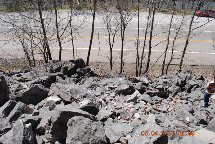
20 Along Hwy 71 South of Westfork PHOTOS OF SITES INVESTIGATED RESULTS


21 PHOTOS OF SITES INVESTIGATED Hwy 71 Debris Pile RESULTS


22 PHOTOS OF SITES INVESTIGATED Evidence of Creep Under I-540 bridge just south of Hwy 74 Evidence of fracture or sink hole? RESULTS


23 SITE WITH MITIGATION TECHNIQUES Private Property Site on Hwy 71 With Terracing and Vegetation RESULTS Lined ditch created to direct water flow and prevent undercutting of slope
24 MATERIALS PRODUCED BY PROJECT Public website with information on hillslope stability Maps in ArcGis and Google Earth identifying potential slope hazard sites in Washington County, Arkansas Google Earth Tour of site field-checking Powerpoint slideshow presentation of project goals, methodology, outcomes and informational content related to potential hillslope failure RESULTS
25 SKILLS GAINED FROM PROJECT EXPERIENCE Teamwork Skills - Members of the team worked together to divide responsibilities and assist other in task completion. Communication skills - Enhanced due to the need to share technical information in a way that could be easily understood. Technological Skills Team members learned to use new technology such as GIS and GPS. Skills in preparation of presentation material (slideshow, google tours, etc.) were learned and/or enhanced by team members. RESULTS
26 Does your presentation convey a knowledge of your subject matter greater than that of your audience CONTENT KNOWLEDGE
27 RELATE GEOLOGICAL PRINCIPLES TO ENVIRONMENTAL ISSUES What factors contribute to slope failure? Steep slopes are out of equilibrium with gravity and WILL eventually fail. Weak bedrock such as shale is particularly susceptible to failure. Other factors (soil type, weathering, erosion, water) can exacerbate the failure process. When is slope failure an environmental issue? When the event occurs in proximity to human population, creating a hazard to life and property. CONTENT

28 SHALE: COMPOSITION AND CHARACTERISTICS A layered sedimentary rock deposited in shallow seas that covered the area during the Mississippian Period, about 325 million years ago. CURRICULUM a clastic rock made up of claysize weathering debris [Clastic - term for rocks composed of broken pieces of older rocks] The process in the rock cycle by which shale is formed is known as compaction. Clay minerals line up with each other in such a way that the rock splits easily on one plane, typically breaking into very small, thin flat pieces. Shale is slick and slides easily on wet surfaces


29 SLOPES AND MASS WASTING Slump occurs when material rotates along a curved surface; can be bedrock, but usually soil Slump will eventually turn into flow Creep is a slow, but destructive, continuous movement of slopes down inclined planes CURRICULUM Evidence of creep includes bent trees and leaning poles Creep is a continuing maintenance problem
30 Define Hazard Zone MASS WASTING: MITIGATION TECHNIQUES Confirm slope steepness gentle slopes do fail, but failure on steep slopes is more likely Identify material present (is the rock weak, like shale?) Determine if there is evidence of previous slide in identified, or immediately adjacent, location Is the site in close proximity to human activity? Evacuate hazardous area and/or post warnings CURRICULUM
31 Creep Slump CURRICULUM EVENT SPECIFIC MITIGATION Fix small cracks as they appear. Deep foundation repair Put in retaining wall with a gravel pack and weep hole Debris Flow Attempt to re-direct the flow with channels and retention basins Block Glide / Rock Fall Attempt to bind large rock more tightly using bolts to anchor slope Cover area with mesh to keep smaller rocks from falling into roads
32 ACKNOWLEDGEMENTS
33 ACKNOWLEDGMENTS Dr. Robyn Dennis CAST University of Arkansas, Fayetteville Mark Lane Civil Engineer, City of Searcy, Arkansas Paul Lowrey Science & Math Faculty/GIS Facilitator Northwest Arkansas Community College, Bentonville, AR C. Dianne Phillips Science & Math Faculty, EAST/EMPACTS Facilitator Northwest Arkansas Community College, Bentonville, AR
34 APPENDIX
35 REFERENCES Disaster, Planning and Development: Managing Natural Hazards to Reduce Loss Environmental Geology Course Material News and Information about Geology Physical Geography Slope Stability, Triggering Events, Mass Movement Hazards
36 RECOMMENDED LINKS Project Website Final Presentation Slope Hazard Fact Sheet Photos of Site Visits Google Earth Tour of Sites Videos Slow Avalanche: Additional Reading Landslide Hazards: Landslide Hazard Information: Slope Stability: Photos Landslide Blog:
Illegal Dumpsite Map and Informational Website
 Illegal Dumpsite Map and Informational Website Dominick Elkins, Faith Cordes, and Shweta Shah Environmental Geology, EMPACTS: Professor Paul Lowrey Fall 2015, NorthWest Arkansas Community College, Bentonville,
Mass Wasting. Revisit: Erosion, Transportation, and Deposition
 Mass Wasting Revisit: Erosion, Transportation, and Deposition While landslides are a normal part of erosion and surface processes, they can be very destructive to life and property! - Mass wasting: downslope
Mass Movements. Rock Weathering. Accumulation of Debris on Slopes. Landslides 12/8/2014
 Mass Movements Already talked a little about landslides with earthquakes AKA mass wasting A mass movement is any displacement of large amounts of soil down slopes over (often) a comparatively short period
Chapter 11 10/30/2013. Mass Wasting. Introduction. Factors That Influence Mass Wasting. Introduction. Factors That Influence Mass Wasting
 Introduction Chapter 11 Mass wasting - The downslope movement of material resulting from the force of gravity. Mass Wasting Mass wasting results when the force of gravity acting on a slope exceeds the
3/8/17. #20 - Landslides: Mitigation and Case Histories. Questions for Thought. Questions for Thought
 #20 - Landslides: Mitigation and Case Histories Web Exercise #3 (Volcanoes) Due Wednesday There is a 2-point penalty for every day the assignment is late. Exam 1 Scores Scores and exam key are posted Vaiont
Engineer. Engineering. Engineering. (in-ja-neer ) A person trained and skilled in any of the various branches of engineering: a civil engineer
 A person trained and skilled in any of the various branches of engineering: a civil engineer") Engineer (in-ja-neer ) A person trained and skilled in any of the various branches of engineering: a civil engineer (Random House Webster s College Dictionary, 1991) CE100 Introduction to Civil Geotechnical
Engineer (in-ja-neer ) A person trained and skilled in any of the various branches of engineering: a civil engineer (Random House Webster s College Dictionary, 1991) CE100 Introduction to Civil Geotechnical
9/13/2011 CHAPTER 9 AND SUBSIDENCE. Case History: La Conchita Landslide. Introduction
 CHAPTER 9 SLOPE PROCESSES, LANDSLIDES, AND SUBSIDENCE Case History: La Conchita Landslide La Conchita: small coastal community 80 km (50 mi) northwest of Los Angeles Landslide occurred on January 10, 2005
9/23/2013. Introduction CHAPTER 7 SLOPE PROCESSES, LANDSLIDES, AND SUBSIDENCE. Case History: La Conchita Landslide
 Introduction CHAPTER 7 SLOPE PROCESSES, LANDSLIDES, AND SUBSIDENCE Landslide and other ground failures posting substantial damage and loss of life In U.S., average 25 50 deaths; damage more than $3.5 billion
Geology 101. Reading Guides for Chapters 5 and 14 Weathering: the Breakdown of Rocks (p. 142)
") Geology 101 Name Reading Guides for Chapters 5 and 14 Weathering: the Breakdown of Rocks (p. 142) Please read the introduction to the chapter. What is the difference between weathering and erosion? Weathering
Geology 101 Name Reading Guides for Chapters 5 and 14 Weathering: the Breakdown of Rocks (p. 142) Please read the introduction to the chapter. What is the difference between weathering and erosion? Weathering
3.18 GEOLOGY AND SOILS
 3.18 GEOLOGY AND SOILS This section discusses geologic resource concerns as they relate to the environment, public safety, and project design both during construction and after completion of the project.
GG101 Lecture 22: Mass Wasting. Soil, debris, sediment, and broken rock is called regolith.
 GG101 Lecture 22: Mass Wasting Mass Wasting is the movement of rock and soil down a slope due to the force of gravity. Soil, debris, sediment, and broken rock is called regolith. Mass wasting creates broad
ADVENTURES IN WATER DEVELOPED BY LOUISVILLE WATER COMPANY
 ADVENTURES IN WATER DEVELOPED BY LOUISVILLE WATER COMPANY Tunneling for Water explains the science behind a first-of-its-kind project in the world! Louisville Water Company is the first water utility
Mass Wasting. Mass Wasting. Earth s s External Processes
 1 Mass Wasting Presentation Modified from Instructor Resource Center on CD-ROM, Foundations of Earth Science, 4 th Edition, Lutgens & Tarbuck Mass Wasting 2 Down-slope movement of rock, loose material
UNIT SEVEN: Earth s Water. Chapter 21 Water and Solutions. Chapter 22 Water Systems. Chapter 23 How Water Shapes the Land
 UNIT SEVEN: Earth s Water Chapter 21 Water and Solutions Chapter 22 Water Systems Chapter 23 How Water Shapes the Land Chapter Twenty-Three: How Water Shapes the Land 23.1 Weathering and Erosion 23.2
Development of an On-Line Interactive GIS Map 1995 OAS Geology Field Trip in NE Oklahoma
 Development of an On-Line Interactive GIS Map 1995 OAS Geology Field Trip in NE Oklahoma JODIE MURRAY BURNS NORTHWEST ARKANSAS COMMUNITY COLLEGE, ROGERS, ARKANSAS FALL 2015 INDEPENDENT STUDY PROJECT PROFESSOR:
Weathering, Soil, and Mass Movements
 Tarbuck Lutgens Weathering, Soil, and Mass Movements 5.1 Weathering Mechanical Weathering Mechanical weathering occurs when physical forces break rock into smaller and smaller pieces without changing the
LOOK OUT BELOW! (1 Hour)
") LOOK OUT BELOW! (1 Hour) Addresses NGSS Level of Difficulty: 2 Grade Range: K-2 OVERVIEW In this activity, students will create a model of a sloped hillside using sand, and then they will simulate conditions
LOOK OUT BELOW! (1 Hour) Addresses NGSS Level of Difficulty: 2 Grade Range: K-2 OVERVIEW In this activity, students will create a model of a sloped hillside using sand, and then they will simulate conditions
August 10, 2007 File:
 August 10, 2007 File: 15-85-72 Alberta Infrastructure and Transportation Room 301, Provincial Building 9621-96 Avenue Peace River, AB T8S 1T4 Attention: Mr. Ed Szmata PEACE REGION (PEACE HIGH LEVEL AREA)
A Homeowner s Guide to Landslides for Washington and Oregon
 Protect Your Home and Property 1 A Homeowner s Guide to Landslides for Washington and Oregon Washington Geological Survey and Oregon Department of Geology and Mineral Industries LANDSLIDES ARE ONE OF THE
Debris flow: categories, characteristics, hazard assessment, mitigation measures. Hariklia D. SKILODIMOU, George D. BATHRELLOS
 Debris flow: categories, characteristics, hazard assessment, mitigation measures Hariklia D. SKILODIMOU, George D. BATHRELLOS Natural hazards: physical phenomena, active in geological time capable of producing
Learning Objectives. Your goals for studying this chapter are: Understand where landslides occur. Understand the warning signs of landslides.
 Learning Objectives Landslides are common problems across the country and in many parts of the world. Next to flooding, they are the most likely natural hazard you may have to deal with in your lifetime.
SCHUSTER SLOPE LANDSCAPE MANAGEMENT PLAN. January 15, 2015
 SCHUSTER SLOPE LANDSCAPE MANAGEMENT PLAN January 15, 2015 1 WHY DO WE NEED A LANDSCAPE MANAGEMENT PLAN? 2 PROCESS FOR DEVELOPING THE SCHUSTER SLOPE LANDSCAPE MANAGEMENT PLAN 3 NORTH DOWNTOWN SUB AREA PLAN
Mass Wasting Landslides, Mudflows. Chapter 7. Geology of the Hawaiian Islands. Any Questions? Mass wasting. Mass wasting.
 Geology of the Hawaiian Islands Class 17 9 March 2004 Any Questions? Mass Wasting, Mudflows Chapter 7 Mass wasting Transportation of large masses of rock Downslope movement of rock and soil debris under
SLOPE PROCESSES, LANDSLIDES, AND SUBSIDENCE
 CHAPTER 9 SLOPE PROCESSES, LANDSLIDES, AND SUBSIDENCE La Conchita slide January 10, 2005 Triggered by heavy rainfall, reactivation along an older landslide surface (35,000 years ago, 6000 years ago, and
EARTH S CHANGING SURFACE
 EARTH S CHANGING SURFACE Weathering Together, weathering and erosion work continuously to wear down the material on Earth s surface. weathering process that breaks down rock and other substances of Earth
1. Erosion by Running Water Most powerful cause of erosion
 I. Destructive Forces Notes: Destructive force: a process in which land is destroyed or changed such as weathering and erosion. All landforms are a result of a combination of constructive and destructive
3.12 Geology and Topography Affected Environment
 3 Affected Environment and Environmental Consequences 3.12 Geology and Topography 3.12.1 Affected Environment 3.12.1.1 Earthquakes Sterling Highway MP 45 60 Project Draft SEIS The Kenai Peninsula is predisposed
Mass Wasting: The Work of Gravity
 Chapter 15 Lecture Earth: An Introduction to Physical Geology Twelfth Edition Mass Wasting: The Work of Gravity Tarbuck and Lutgens Chapter 15 Mass Wasting The Importance of Mass Wasting Slopes are the
( Your responses must be complete, using terminology and concepts.
 Running head: ARTICLE SUMMARY 1 Question Topic: Summary of information about website http://www.tulane.edu/~sanelson/geol204/masswastproc.htm Pages: 3 Sources: 4 Format: APA Deadline: 24 hours Instructions:
Crystal Moncada. California State University San Bernardino. January- July Brett R. Goforth- Department of Geography and Environmental Studies
 A Geographical Information System (GIS) Based Evaluation of Landslide Susceptibility Mapped on the Harrison Mountain Quadrangle of the Santa Ana River Watershed Crystal Moncada California State University
Mass Wasting. Requirements for Mass Wasting. Slope Stability. Geol 104: mass wasting
 Mass Wasting Movement of earth materials downslope, driven by Gravitational Forces. Landslides - general term for rock or soil movement. In U.S., on average, mass wasting causes 1 to 2 billion dollars
Section 5.1 Weathering This section describes different types of weathering in rocks.
 Section 5.1 Weathering This section describes different types of weathering in rocks. Reading Strategy Building Vocabulary As you read the section, define each vocabulary term. For more information on
 265 Dalewood Way alteration permit #2016/02/17/9761 June 30, 2016 Appeal #16-109 Deck at Rear due to conflict with Slope Protection Act A. Executive Summary: We are in receipt of the Notification of Structural
Mapping Hobbs State Park Spring 2015 Luke Dye Daryk Blackford
 Mapping Hobbs State Park Spring 2015 Luke Dye Daryk Blackford Introduction to Geographic Information Science Northwest Arkansas Community College Instructor Paul Lowrey Hobbs State Park-Conservation Area
Chapter 12 Weathering and Erosion
 Chapter 12 Weathering and Erosion Multiple Choice Select the definition that most nearly defines the given word. 1. Landform A. chemical combination of metallic elements with oxygen B. layer of weathered
SLOPE FAILURE SLOPES. Landslides, Mudflows, Earthflows, and other Mass Wasting Processes
 GEOL g406 Environmental Geology SLOPE FAILURE Landslides, Mudflows, Earthflows, and other Mass Wasting Processes Read Chapter 5 in your textbook (Keller, 2000) Gros Ventre landslide, Wyoming S. Hughes,
ENGINEERING EVALUATION OF THE STANLEY MINE ADVENTURE PARK AREA CLEAR CREEK COUNTY, COLORADO. Prepared for:
 braun Braun Consulting Engineers ENGINEERING EVALUATION OF THE STANLEY MINE ADVENTURE PARK AREA CLEAR CREEK COUNTY, COLORADO Prepared for: STANLEY MINES ADENTURE PARK 3375 W. POWERS CIRCLE LITTLETON, COLORADO
Engineering Geology ECIV 3302
 Engineering Geology ECIV 3302 Instructor : Dr. Jehad Hamad 2019-2018 Chapter (5) Weathering & Soil Chapter 5: Weathering, Soil, and Mass Wasting External processes include : (1) Weathering (2) Mass wasting
Mass Wasting. 3 Types of Mass Wasting
 Mass Wasting 3 Types of Mass Wasting Unless otherwise noted the artwork and photographs in this slide show are original and by Burt Carter. Permission is granted to use them for non-commercial, non-profit
Changes to Land 5.7B. landforms: features on the surface of Earth such as mountains, hills, dunes, oceans and rivers
 All the landforms on Earth have changed over time and continue to change. Many of the changes were caused by wind, moving water, and moving ice. Mountains have grown and shrunk. Rivers have cut away land
Think about the landforms where you live. How do you think they have changed over time? How do you think they will change in the future?
 reflect All the landforms on Earth have changed over time and continue to change. Many of the changes were caused by wind, moving water, and moving ice. Mountains have grown and shrunk. Rivers have cut
Assessing Slope Instabilities. Victoria Leffel & Joey Franzino
 Assessing Slope Instabilities Victoria Leffel & Joey Franzino Slope Stability and Landslides Today s Presentation: Slope instability and landslide terms will be used interchangeably Landslide: downward
Sherman Falls -Virtual Field Trip-
 Sherman Falls -Virtual Field Trip- School of GEOGRAPHY & GEOLOGY Carolyn Eyles & Susan Vajoczki Prepared by Zachary Windus and Liz Kenny Directions: McMaster University to Sherman Falls From McMaster University
EMERGENCY WARNING SYSTEM PROCEDURES FOR DEBRIS FLOWS IN WESTERN OREGON
 EMERGENCY WARNING SYSTEM PROCEDURES FOR DEBRIS FLOWS IN WESTERN OREGON Updated: 12/03/2007 by the Oregon Department of Forestry and the Oregon Department of Geology and Mineral Industries Debris flows
Using Weather and Climate Information for Landslide Prevention and Mitigation
 Using Weather and Climate Information for Landslide Prevention and Mitigation Professor Roy C. Sidle Disaster Prevention Research Institute Kyoto University, Japan International Workshop on Climate and
Downtown Anchorage Seismic Risk Assessment & Land Use Regulations to Mitigate Seismic Risk
 Prepared for: The Municipality of Anchorage Planning Department and the Geotechnical Advisory Commission Downtown Anchorage Seismic Risk Assessment & Land Use Regulations to Mitigate Seismic Risk Prepared
Earth Science, 10e. Edward J. Tarbuck & Frederick K. Lutgens
 Earth Science, 10e Edward J. Tarbuck & Frederick K. Lutgens Weathering, Soil, and Mass Wasting Chapter 3 Earth Science, 10e Stan Hatfield and Ken Pinzke Southwestern Illinois College Earth's external processes
PHYSICAL GEOGRAPHY. By Brett Lucas
 PHYSICAL GEOGRAPHY By Brett Lucas WEATHERING & MASS WASTING Denudation Disintegration, wearing away, and removal of rock material Involves three activities: Weathering is the break down of rocks into smaller
Ch. 8: Mass Movements, Wind and Glaciers
 Ch. 8: Mass Movements, Wind and Glaciers Every day the landscape around us undergoes changes. Changes that are powered by gravity alone are called mass movement or mass wasting. Mass movement includes
Geog 1000 Lecture 17: Chapter 10
 Geog 1000 Lecture 17: Chapter 10 Landslides and Mass Movements Link to lectures: http://scholar.ulethbridge.ca/chasmer/classes/ Today s Lecture 1. Assignment 2 Due Pick up Assignment 1 if you don t have
Bell Ringer. Are soil and dirt the same material? In your explanation be sure to talk about plants.
 Bell Ringer Are soil and dirt the same material? In your explanation be sure to talk about plants. 5.3 Mass Movements Triggers of Mass Movements The transfer of rock and soil downslope due to gravity is
Pratice Surface Processes Test
 1. The cross section below shows the movement of wind-driven sand particles that strike a partly exposed basalt cobble located at the surface of a windy desert. Which cross section best represents the
Consists of cliff face (free-face) and talus slope or upper convex slope, a straight slope and a lower concave slope
 and talus slope or upper convex slope, a straight slope and a lower concave slope") 1 2 3 4 5 6 7 8 Introduction to Environmental Geology, 5e Chapter 10 Slope Processes, Landslides, and Subsidence Mass wasting: summary in haiku form Mass wasting: downhill quickly like an avalanche, or
1 2 3 4 5 6 7 8 Introduction to Environmental Geology, 5e Chapter 10 Slope Processes, Landslides, and Subsidence Mass wasting: summary in haiku form Mass wasting: downhill quickly like an avalanche, or
Roxann Fiedorowicz, Shana Martin, Jesse Pierce and Gerri Weatherford
 An educational collaboration between NorthWest Arkansas Community College and John Tyson Elementary GT Program Roxann Fiedorowicz, Shana Martin, Jesse Pierce and Gerri Weatherford C. Dianne Phillips, Associate
LANDSLIDE HAZARDS. presented during the. TRAINING-WORKSHOP ON DISASTER RISK MANAGEMENT Rakdell Inn Virac, Catanduanes 03 July 2008
 LANDSLIDE HAZARDS presented during the TRAINING-WORKSHOP ON DISASTER RISK MANAGEMENT Rakdell Inn Virac, Catanduanes 03 July 2008 GEOLOGIC HAZARDS the probability of occurrence, within a specific period
HW #2 Landscape Travel from A to B 12,
 HW #2 Landscape 2016 Section: Name: ate: 1. ase your answer(s) to the following question(s) on the map below, which represents two bridges that cross the Green River. Letters,, and represent locations
CHAPTER FIVE 5.0 STABILITY OF CUT SLOPES IN THE STUDY AREA. them limited by a thick canopy of vegetation and steep slope angles.
 CHAPTER FIVE 5.0 STABILITY OF CUT SLOPES IN THE STUDY AREA 5.1. Introduction Ukay Perdana area is a developing community with continuous building activities and road construction. There are thus only left
Unit 3 Rocks, Minerals, Soil Twitter Review Questions
 Unit 3 Rocks, Minerals, Soil Twitter Review Questions U3-1: Which type of rock is most representative of a slow cooling process of molten material? (Be specific) - Answer: Intrusive Igneous Rock U3-2:
Volcanoes. Environmental Geology, Mr. Paul Lowrey Stacey Singleton, Cassandra Combs, Dwight Stephenson, Matt Smithyman
 Volcanoes Environmental Geology, Mr. Paul Lowrey Stacey Singleton, Cassandra Combs, Dwight Stephenson, Matt Smithyman EMPACTS Project, Spring 2017 Northwest Arkansas Community College, Bentonville, AR
PEACE RIVER EAST HILL - HWY 2:60 (PH2) SELECT PHOTOGRAPHS August 22, 2007 File: Photo E003. Station May 2007
 SELECT PHOTOGRAPHS August 22, 2007 File: Photo E003. Station May 2007") Photo E003 0+000 Viewing looking upslope at Site 4 from highway. Conditions unchanged from 2006. Photo E018 0+000 Localized erosion within road fill on upslope side of highway. Photo E022 0+250 Looking
Photo E003 0+000 Viewing looking upslope at Site 4 from highway. Conditions unchanged from 2006. Photo E018 0+000 Localized erosion within road fill on upslope side of highway. Photo E022 0+250 Looking
GEOL 314 Engineering Geology
 GEOL 314 Engineering Geology Dr. Robert Mitchell ES234 Winter 2013 650-3591 robert.mitchell@wwu.edu http://kula.geol.wwu.edu/rjmitch/ Office Hours: MWF 2-3:00 pm or by arrangement Text: Geotechnical Engineering
GOAL 7 AREAS SUBJECT TO NATURAL DISASTERS AND HAZARDS. To protect life and property from natural disasters and hazards.
 GOAL 7 AREAS SUBJECT TO NATURAL DISASTERS AND HAZARDS A. GOALS: To protect life and property from natural disasters and hazards. B. POLICIES: 1. Floodplains shall be maintained as natural drainage-ways.
Geology 101. Reading Guides for Chapters 6 and 12
 Geology 101 Name Chapter 6: Weathering and Soils (p. 160): Reading Guides for Chapters 6 and 12 This chapter is about the processes involved in the disintegration of rock. Weathering is often mistaken
SLOPE STABILITY LAB INTRODUCTION
 INTRODUCTION SLOPE STABILITY LAB Slope Stability 1 Hills are made of various types of rocks. Some hills are made large layers of strong rock, others are made of unconsolidated sands. The slope of the hillside
Gateway Trail Project
 Gateway Trail Project Debris Flow Hazard Assessment By: Juan de la Fuente April 30, 2010 Background- On April 22, 2010, the Shasta-Trinity National Forest (Mt. Shasta-McCloud Unit) requested a geologic
DEVIL'S DEN STATE PARK TRAIL MAPPING OF GEOLOGICAL HAZARDS & POSSIBLE PREVENTIONS
 TRAIL MAPPING OF GEOLOGICAL HAZARDS & POSSIBLE PREVENTIONS AERIAL VIEW OF PARK The outcome of our teams project is to help the visitors to Devil s Den State Park by providing information that can help
Landslides & Debris Flows
 T.#Perron# #12.001# #Landslides#&#Debris#Flows# 1# Landslides & Debris Flows Many geologic processes, including those shaping the land surface, are slowacting, involving feedbacks that operate over many
Chapter 5 Weathering Soil And Mass Movement
 CHAPTER 5 WEATHERING SOIL AND MASS MOVEMENT PDF - Are you looking for chapter 5 weathering soil and mass movement Books? Now, you will be happy that at this time chapter 5 weathering soil and mass movement
CHAPTER GEOLOGICALLY HAZARDOUS AREAS Applicability Regulations.
 CHAPTER 19.07 GEOLOGICALLY HAZARDOUS AREAS 19.07.010 Applicability. Geologically hazardous areas may pose a threat to the health and safety of citizens when incompatible development is sited in areas of
4 th Grade Science Unit C: Earth Sciences Chapter 6: Minerals and Rocks Lesson 1: What are minerals?
 4 th Grade Science Unit C: Earth Sciences Chapter 6: Minerals and Rocks Lesson 1: What are minerals? mineral A mineral is a natural, nonliving, solid crystal that makes up rocks. All over the world, each
Page 1. Weathering & Erosion by Mass Wasting Pre-Test. Name:
 Weathering & Erosion by Mass Wasting Pre-Test 3048-1 - Page 1 Name: 1) As a particle of sediment in a stream breaks into several smaller pieces, the rate of weathering of the sediment will A) increase
Chapter 2. Wearing Down Landforms: Rivers and Ice. Physical Weathering
 Chapter 2 Wearing Down Landforms: Rivers and Ice Physical Weathering Weathering vs. Erosion Weathering is the breakdown of rock and minerals. Erosion is a two fold process that starts with 1) breakdown
SESSION 6: FLUVIAL LANDFORMS
 SESSION 6: FLUVIAL LANDFORMS KEY CONCEPTS: Fluvial Landforms Management of River Catchment Areas Slope Elements X-PLANATION: FLUVIAL LANDFORMS Rivers form landforms as they erode the landscape. These landforms
Stream Geomorphology. Leslie A. Morrissey UVM July 25, 2012
 Stream Geomorphology Leslie A. Morrissey UVM July 25, 2012 What Functions do Healthy Streams Provide? Flood mitigation Water supply Water quality Sediment storage and transport Habitat Recreation Transportation
Unit 3 Study Guide -- Greenberg science, 6C
 Unit 3 Study Guide -- Greenberg science, 6C Name Pd. Date / / 2018 + +5 extra credit points on the test if submitted complete and correct ON THE TEST DATE. + A copy can be found on my website mgreenberg.weebly.com
Earth Systems Curriculum
 Earth Systems Curriculum Course Description This course provides the opportunity to develop knowledge and understanding about the relationships between the structure, processes, and resources on Earth
Practical reliability approach to urban slope stability
 University of Wollongong Research Online Faculty of Engineering - Papers (Archive) Faculty of Engineering and Information Sciences 2011 Practical reliability approach to urban slope stability R. Chowdhury
The Importance of Mass Wasting
 Mass Wasting: The Work of Gravity Earth Chapter 15 Chapter 15 Mass Wasting The Importance of Mass Wasting Slopes are the most common elements in our physical landscape Slopes may appear to be stable, but
International Journal of Modern Trends in Engineering and Research e-issn No.: , Date: April, 2016
 International Journal of Modern Trends in Engineering and Research www.ijmter.com e-issn No.:2349-9745, Date: 28-30 April, 2016 Landslide Hazard Management Maps for Settlements in Yelwandi River Basin,
Preliminaries to Erosion: Weathering and Mass Wasting
 Preliminaries to Erosion: Weathering & Mass Wasting All things deteriorate in time. Virgil 1 Preliminaries to Erosion: Weathering and Mass Wasting Denudation The Impact of Weathering and Mass Wasting on
Landslide Mitigation (BYUI)
") Landslide Mitigation (BYUI) The general principle behind landslide mitigation is stabilization. Slopes that are too steep are shallowed or strengthened. Loose rocks can be bolted or cemented into place.
Landslide Mitigation (BYUI) The general principle behind landslide mitigation is stabilization. Slopes that are too steep are shallowed or strengthened. Loose rocks can be bolted or cemented into place.
Response on Interactive comment by Anonymous Referee #1
 Response on Interactive comment by Anonymous Referee #1 Sajid Ali First, we would like to thank you for evaluation and highlighting the deficiencies in the manuscript. It is indeed valuable addition and
ENGINEER S CERTIFICATION OF FAULT AREA DEMONSTRATION (40 CFR )
") PLATTE RIVER POWER AUTHORITY RAWHIDE ENERGY STATION BOTTOM ASH TRANSFER (BAT) IMPOUNDMENTS LARIMER COUNTY, CO ENGINEER S CERTIFICATION OF FAULT AREA DEMONSTRATION (40 CFR 257.62) FOR COAL COMBUSTION RESIDUALS
PLATTE RIVER POWER AUTHORITY RAWHIDE ENERGY STATION BOTTOM ASH TRANSFER (BAT) IMPOUNDMENTS LARIMER COUNTY, CO ENGINEER S CERTIFICATION OF FAULT AREA DEMONSTRATION (40 CFR 257.62) FOR COAL COMBUSTION RESIDUALS
Landslides and Ground Water Permeability with Respect to the. Contact Point of Glacial Lake Vermont and the Champlain Sea
 Landslides and Ground Water Permeability with Respect to the Contact Point of Glacial Lake Vermont and the Champlain Sea Sediments at Town Line Brook, Winooski, VT Michala Peabody Lara Vowles Abstract:
Read Across America. Listen as I read for facts about Volcanoes. In the Shadow of the Volcano
 Read Across America Listen as I read for facts about Volcanoes. In the Shadow of the Volcano Constructive & Destructive Processes Earth s surface is always changing. Blowing wind and flowing water causes
Impact : Changes to Existing Topography (Less than Significant)
") 4.2 Land Resources 4.2.1 Alternative A Proposed Action Impact 4.2.1-1: Changes to Existing Topography (Less than Significant) Development of the project site would involve grading and other earthwork as
4.2 Land Resources 4.2.1 Alternative A Proposed Action Impact 4.2.1-1: Changes to Existing Topography (Less than Significant) Development of the project site would involve grading and other earthwork as
To get you thinking Explain how these different layers of rock formed? Why are these layers different colors? Sedimentary Rocks
 To get you thinking Explain how these different layers of rock formed? Why are these layers different colors? Sedimentary Rocks Bryce Canyon, Utah Badlands, South Dakota Weathering Whenever rock is exposed
Interpretive Map Series 24
 Oregon Department of Geology and Mineral Industries Interpretive Map Series 24 Geologic Hazards, and Hazard Maps, and Future Damage Estimates for Six Counties in the Mid/Southern Willamette Valley Including
Understanding Earth Fifth Edition
 Understanding Earth Fifth Edition Grotzinger Jordan Press Siever Chapter 16: WEATHERING, EROSION, AND MASS WASTING Interface Between Climate and Tectonics Lecturer: H Mohammadzadeh Assistant professors,
Landslide Mapping and Hazard Analysis for a Natural Gas Pipeline Project
 CIVIL GOVERNMENT SERVICES MINING & METALS OIL, GAS & CHEMICALS POWER Albert Kottke, Mark Lee, & Matthew Waterman Landslide Mapping and Hazard Analysis for a Natural Gas Pipeline Project Technical Innovation
Unsafe Ground: Landslides and Other Mass Movements
 Unsafe Ground: Landslides and Other Mass Movements Mass Movements Downslope motion of earth materials by gravity. Mass movements are a type of natural hazard. Natural feature of the environment. Can cause
9. GEOLOGY, SOILS, AND MINERALS
 June 28, 2018 Page 9-1 9. GEOLOGY, SOILS, AND MINERALS This EIR chapter describes the existing geological, soil, and mineral conditions in the planning area. The chapter includes the regulatory framework
 Rock Slope Analysis Small and Large Scale Failures Mode of Failure Marklands Test To establish the possibility of wedge failure. Plane failure is a special case of wedge failure. Sliding along
PEACE REGION GRANDE PRAIRIE GEOHAZARD RISK ASSESSMENT SITE INSPECTION FORM NAD 83 COORDINATES N 6,178,811 E 403,309
 PEACE REGION GRANDE PRAIRIE GEOHAZARD RISK ASSESSMENT SITE INSPECTION FORM SITE NUMBER GP-4a LEGAL DESCRIPTION LSD 12-10-78-4-W6M SITE NAME Burnt River Bridge - West Approach Slide HIGHWAY & KM Hwy 49:06
Section 3. Slopes and Landscapes. What Do You See? Think About It. Investigate. Learning Outcomes
 Chapter 4 Surface Processes Section 3 Slopes and Landscapes What Do You See? Learning Outcomes In this section, you will Calculate the angle of repose for different kinds of soils and other granular materials.
UGRC 144 Science and Technology in Our Lives/Geohazards
 UGRC 144 Science and Technology in Our Lives/Geohazards Session 3 Understanding Earthquakes and Earthquake Hazards Lecturer: Dr. Patrick Asamoah Sakyi Department of Earth Science, UG Contact Information:
Essentials of Geology, 11e
 Essentials of Geology, 11e and s Chapter 5 Instructor Jennifer Barson Spokane Falls Community College Geology 101 Stanley Hatfield Southwestern Illinois College Jennifer Cole Northeastern University Earth
UGRC 144 Science and Technology in Our Lives/Geohazards
 UGRC 144 Science and Technology in Our Lives/Geohazards Flood and Flood Hazards Dr. Patrick Asamoah Sakyi Department of Earth Science, UG, Legon College of Education School of Continuing and Distance Education
1. Any process that causes rock to crack or break into pieces is called physical weathering. Initial product = final product
 Weathering 1. Any process that causes rock to crack or break into pieces is called physical weathering. Initial product = final product End Result of physical weathering is increased surface area. 2. Physical
Your web browser (Safari 7) is out of date. For more security, comfort and the best experience on this site: Update your browser Ignore
 is out of date. For more security, comfort and the best experience on this site: Update your browser Ignore") Your web browser (Safari 7) is out of date. For more security, comfort and the best experience on this site: Update your browser Ignore BEDRO CK For the complete encyclopedic entry with media resources,
Your web browser (Safari 7) is out of date. For more security, comfort and the best experience on this site: Update your browser Ignore BEDRO CK For the complete encyclopedic entry with media resources,