OCEAN DRILLING PROGRAM LEG 171B SCIENTIFIC PROSPECTUS BLAKE NOSE
|
|
|
- Barry Cox
- 5 years ago
- Views:
Transcription
1 OCEAN DRILLING PROGRAM LEG 171B SCIENTIFIC PROSPECTUS BLAKE NOSE Dr. Richard D. Norris Co-Chief Scientist Woods Hole Oceanographic Institute Dept. of Geology and Geophysics MS 23 Woods Hole MA Dr. Adam Klaus Staff Scientist Ocean Drilling Program Texas A&M University Research Park 1000 Discovery Drive College Station, Texas Dr. Dick Kroon Co-Chief Scientist University of Edinburgh Grant Inst. Dept. of Geology and Geophysics West Mains Road Edinburgh EH9 3JW U.K. Paul J. Fox Director Science Operations Jack Baldauf Manager Science Operations Timothy J.G. Francis Deputy Director Science Operations June 1996
2 Material in this publication may be copied without restraint for library, abstract service, educational, or personal research purposes; however, republication of any portion requires the written consent of the Director, Ocean Drilling Program, Texas A&M University Research Park, 1000 Discovery Drive, College Station, Texas ,, as well as appropriate acknowledgment of this source. No. 72 First Printing 1996 Distribution Electronic copies of this publication may be obtained from the ODP Publications Home Page on the World Wide Web at D I S C L A I M E R This publication was prepared by the Ocean Drilling Program, Texas A&M University, as an account of work performed under the international Ocean Drilling Program, which is managed by Joint Oceanographic Institutions, Inc., under contract with the National Science Foundation. Funding for the program is provided by the following agencies: Canada/Australia Consortium for the Ocean Drilling Program Deutsche Forschungsgemeinschaft (Federal Republic of Germany) Institut Français de Recherche pour l Exploitation de la Mer (France) Ocean Research Institute of the University of Tokyo (Japan) National Science Foundation (United States) Natural Environment Research Council (United Kingdom) European Science Foundation Consortium for the Ocean Drilling Program (Belgium, Denmark, Finland, Iceland, Italy, The Netherlands, Norway, Spain, Sweden, Switzerland, and Turkey) Any opinions, findings, and conclusions or recommendations expressed in this publication are those of the author(s) and do not necessarily reflect the views of the National Science Foundation, the participating agencies, Joint Oceanographic Institutions, Inc., Texas A&M University, or Texas A&M Research Foundation. This is based on pre-cruise JOIDES panel discussions. The operational plans within reflect JOIDES Planning Committee and thematic panel priorities. During the course of the cruise, actual site operations may indicate to the Co-Chief Scientists and the Operations Superintendent that it would be scientifically or operationally advantageous to amend the plan detailed in this prospectus. It should be understood that any proposed changes to the plan presented here are contingent upon approval of the Director of the Ocean Drilling Program in consultation with the Planning Committee and the Pollution Prevention and Safety Panel.
3 Page 3 ABSTRACT The origin of deep waters is a fundamental control on biogeochemical cycles and global climate. Analysis of time periods in which deep-water formation and global temperature gradients may have been much different from well-known Pleistocene variability offers a test of the models developed to explain climate change. Oceanic circulation in the Paleogene and Cretaceous was quite different from that of the modern ocean in part because of the greenhouse conditions that existed during part of this time and the apparent absence of major centers for deep-water formation in the northern basins. Many authors have suggested that deep-water circulation was enhanced in the Cretaceous and Paleogene by the production of warm, saline waters by evaporation in marginal seas such as the basins of the Tethys, but there are few observational data to provide unequivocal support for this Warm Saline Deep Water hypothesis. The sediments on the Blake Plateau and Blake Nose in the Western North Atlantic offer an ideal record for reconstructing water-mass chemistry and circulation in the Cretaceous and early Cenozoic. The plateau s location in the Northern Hemisphere, proximal to the western end of the Tethys seaway, makes the deposited sediments ideal for determining northern sources of deep and intermediate waters. Ocean Drilling Program Leg 171B will drill five sites in a transect from the margin of the Blake Plateau to the edge of the Blake Escarpment. Paleogene and Barremian Maastrichtian strata crop out or are present at shallow burial depths in present water depths of 1200 m to more than 2700 m across the plateau. Today this depth range spans deep thermocline water to upper North Atlantic Deep Water. The plateau spanned a similar range of depths in the early Cenozoic because margin subsidence was largely complete by the Early Cretaceous, and minor subsidence since then is partly offset by reduced sea level after the Eocene. The proposed transect of cores will be used to (1) interpret the sea-level history and associated vertical structure of the Paleogene and Cretaceous oceans and test the Warm Saline
4 Page 4 Deep Water hypothesis near the proposed source areas; (2) provide critically needed lowlatitude sediments for interpreting tropical sea-surface temperature (SST) and climate cyclicity in the Cretaceous and Paleogene; (3) study the effects of sea-level change on sedimentation patterns down the continental slope during the Cretaceous and Paleogene; (4) provide well-preserved microfossils for refinement of low-latitude Paleogene and Cretaceous chronologies and evolutionary dynamics; (5) recover complete Cretaceous/Paleogene and Paleocene/Eocene boundaries along a depth transect to describe the events surrounding the boundary and water depth-related changes in sedimentation of the boundary beds; (6) recover sections suitable for magneto-stratigraphy so that low-latitude biochronologies may be tied directly to the magnetic reversal record; and (7) interpret the thermocline and intermediate water structure of low-latitude, Early Cretaceous oceans and refine the biochronology of this period.
5 Page 5 INTRODUCTION The deep waters of the world represent one of the largest reservoirs of nutrients and CO 2 in the biosphere. The history of deep ocean circulation is integrally tied to the CO 2 storage capacity of the oceans and the preservation of carbonate sediments in the deep sea (Farrell and Prell, 1991). Aging of deep water by remineralization of sinking organic material makes these waters extremely corrosive and gives them a major role in the inorganic carbon cycle by remineralizing carbonates that would otherwise be stored in sedimentary sequences. Hence, changes in the age and sources of deep waters regulate the alkalinity and CO 2 content of the deep sea. Studies of Paleogene and Cretaceous deep-water circulation and its impact on low-latitude climate are needed to understand the mechanisms that regulate the formation and geographic distribution of nutrient-rich deep waters in the modern oceans. Examining deep-water history during periods with different boundary conditions will allow us to better appreciate the mechanisms that drive biogeochemical cycles. Ocean Drilling Program (ODP) Leg 171B will drill a transect on the Blake Nose (Figs. 1, 2) to test current models for the Paleogene and Cretaceous history of intermediate and deep waters in the Atlantic and Tethys. Recovery of well-preserved pelagic microfossils and a detailed history of sediment sources will be used to determine the linkages between climatic and biological evolution and changes in deep-water circulation during the Paleogene and Cretaceous. Presently, deep waters are formed in the North Atlantic and Southern Ocean, and it is the mixture and aging of these water masses that produces the characteristic chemistries of the deep Indian and Pacific Oceans. The distribution of δ 13 C in Paleogene benthic foraminifers suggest that most deep waters of this era have a southern source, but periods of weak latitudinal gradients and short episodes of anomalously warm deep water indicate that deep or intermediate waters may have formed near the equator or in a northern source area (Miller et al., 1987; Barrera and Huber, 1990; Stott and Kennett, 1990; Pak and Miller, 1992). An-
6 Page 6 other theory is that intermittent production of Warm Saline Deep Water may have continued in the Oligocene to middle Miocene in the remnants of the Tethys seaway (Woodruff and Savin, 1989). Alternatively, northern component waters may have formed throughout this time, most probably in the North Atlantic (Wright et al., 1992). The absence of a Paleogene depth transect in the North Atlantic prevents resolution of this debate. The northern subtropical location of the Blake Plateau and its position adjacent to the western opening of the Tethys seaway would place it in the mixing zone between water masses of different origins during the Paleogene and Late Cretaceous. Most reconstructions of deep-water geometry have focused on the late Neogene to Holocene record. Paleogene sequences have generally been too deeply buried to be recovered either completely or consistently along depth transects. Yet, the three-dimensional structure of Mesozoic and early Cenozoic oceans is of great interest because these oceans record climates and patterns of water-mass development under conditions different from those of modern seas. As such, an understanding of Paleogene and Cretaceous deep-water structure is necessary to provide boundary conditions on global climate models (GCMs) and test the assumptions employed in models of the Quaternary oceans. Likewise, records of surfacewater temperatures and variations in biotic assemblages are needed to constrain reconstructions of latitudinal thermal gradients. BACKGROUND Depth-Transect Strategy Recently, much attention has been focused on reconstructing the Cenozoic history of deepwater chemistry and carbonate dissolution by drilling depth transects in the equatorial oceans. Transects have been drilled on the Walvis Ridge in the South Atlantic, Ontong-Java Plateau in the Pacific, Madinley Rise and Oman margin in the Indian Ocean, Maud Rise in the Southern Ocean, and, most recently, the Ceara Rise in the equatorial Atlantic. The strategy behind these transects is to determine bathymetric changes in carbonate preservation.
7 Page 7 These data provide a history of changes in the lysocline depth, oceanic alkalinity, and surface ocean carbonate production (e.g., Curry et al., 1990; Peterson et al., 1992; Berger et al., 1993). Transects that include sites at shallow depths also can be used to reconstruct the changes in sources of intermediate waters and detect patterns of water-mass circulation (Curry and Lohmann, 1986; Slowey and Curry, 1987; Kennett and Stott, 1990). The origins of a water mass can be inferred both by measuring the characteristic δ 13 C and Cd chemistry preserved in benthic foraminifers and by analyzing the faunal composition (Streeter and Shackleton, 1979; Boyle and Keigwin, 1982; Curry et al., 1988; Boyle, 1990; Charles and Fairbanks, 1992; Wright et al., 1992; Oppo and Rosenthal, 1994). The best existing depth transect through pre-neogene sections was drilled on Maud Rise during ODP Leg 113. The transect of two sites found intriguing evidence for deep-water formation at low latitudes (the Warm Saline Deep Water hypothesis; Kennett and Stott, 1990). However, these sites were within the region of formation of southern source waters and are not well located to detect the chemistry or history of northern source waters, should they exist. A depth transect in the North Atlantic would be well placed to identify northern component water masses. Patterns of mixing between water masses from different sources could be used to reconstruct their three-dimensional structure and origins (Corfield and Norris, 1996). The depth transect will aid in documentation of patterns of sedimentation across the slope and the history of ocean circulation. STUDY AREA Marine Geology Blake Nose, or Blake Spur, is a salient on the eastern margin of the Blake Plateau, due east of northern Florida (Figs. 1, 2). It is mostly less than 1000 m deep but drops sharply to water depths >4000 m at the Blake Escarpment a nearly vertical wall formed by erosion of the continental slope. In contrast, the Blake Nose is a gentle ramp that reaches a maximum
8 Page 8 depth of about 2700 m at the Blake Escarpment. The Blake Plateau and Blake Nose are composed of an 8 12 km thick sequence of Jurassic and lower Cretaceous limestones that are capped by less than 1 km of Upper Cretaceous and Cenozoic deposits (Benson, Sheridan, et al., 1978). Seismic records show the presence of buried reef buildups at the landward end of the Blake Nose (Figs. 2, 3). Fore-reef deposits and pelagic oozes, built seaward of the reef front, rest on relatively flat-lying Neocomian Barremian shallow-water carbonates and serve largely to define the present bathymetric gradient along the Blake Nose. A hiatus probably exists between the Aptian Albian and the Campanian. Upper Cretaceous to middle Eocene carbonate oozes that rest on the Barremian reef-front deposits are typically < m thick. Paleobathymetry Shallow-water limestone of Barremian age with a foraminiferal fauna that suggests depths of deposition of <50 mbsl was recovered at Deep Sea Drilling Project (DSDP) Site 390 (Benson, Sheridan, et al., 1978). Water depths increased substantially by the late Albian. Aptian Albian pelagic oozes at the eastern end of the Blake Nose were probably deposited at >500 m water depth based on ratios of planktonic and benthic foraminifers (Benson, Sheridan, et al., 1978). If we assume that the reef was at sea level during the Albian Aptian and that the depth gradient in the fore-reef deposits has not changed since that time, then the present difference in depth between the reef top and the seaward edge of the Blake Nose (~1500 m) probably reflects the greatest water depth at which the oozes were deposited on Blake Nose during the Aptian Albian interval. Upper Cretaceous and younger sediments were probably deposited near their present range of water depths ( m; Benson, Sheridan, et al., 1978). Seismic Stratigraphy Six distinctive reflectors penetrated at Site 390 (Fig. 3) are hypothesized to be of the following ages and lithologies:
9 Page 9 1. Oligocene/Eocene nannofossil ooze and phosphorite (Reflector Orange); 2. Paleocene/lower Eocene nannofossil ooze and chert (Reflector Red); 3. Lower/upper Paleocene nannofossil ooze (Reflector Green); 4. Campanian nannofossil ooze (Reflector Purple); 5. Aptian Albian variegated nannofossil claystone (Reflector Blue); and 6. Aptian Albian/ Barremian periplatform limestone (Reflector Yellow). Tracing these reflectors updip along the Glomar Challenger single-channel seismic (SCS) line to its intersection with multichannel seismic (MCS) Line TD-5 shows that the Eocene and lower Paleocene Campanian sediments appear to have nearly uniform thicknesses across most of the Blake Nose (Fig. 4). The middle Eocene is typically about 75 m thick, as it is at DSDP Site 390, whereas the lower Paleocene Campanian sequence is about 45 m thick and consists of about 20 m of Paleocene and 20 m of Maastrichtian sediments. The Eocene and Paleocene intervals thin, but do not pinch out, at the extreme western end of the Blake Nose on MCS Line TD-5UW because sediments of these ages are found in USGS borehole ASP-3. In contrast, the middle to upper Paleocene is highly variable in thickness, ranging from about 20 m at Site 390 to about 200 m in several areas updip of this site. On Gloria Farnella 1987 SCS Line 18, the middle Paleocene varies in thickness and appears to fill a channel in the lower Paleocene/Upper Cretaceous sequence. Hence, there may be an unconformity in the middle Paleocene. Reflector Purple forms a strong and laterally continuous reflector from the Blake Escarpment to the Blake Plateau. Immediately below Reflector Purple there is a series of strong reflectors that pinch out against this surface. Apparently, Reflector Purple is a major erosional surface of early Campanian age or older. SCS lines made during the Glomar Challenger initial survey and more recent SCS and
10 Page 10 MCS lines show that as much as 800 m of strata is between the Campanian and Aptian reflectors updip of Site 390. These mid-cretaceous to Barremian deposits form a series of major clinoforms that build out from, and ultimately overlap, a reef complex that underlies Reflector Yellow (Barremian). Reflector Purple (?pre-campanian) truncates these clinoforms. There may be two cycles of erosion within the clinoform stack because those that overlap the reef complex downlap against underlying clinoform deposits. The lithology of the mid-cretaceous(?) sediments that make up the clinoform stack is unknown. However, deposits immediately below Reflector Purple at Site 390 are nannofossil oozes and calcareous clays of Aptian Albian age. The Aptian ooze at Site 390 can be traced updip in MCS Line TD-5 into the upper sequence of clinoforms below Reflector Purple. These clinoforms are successively cut into by the pre-campanian erosion surface, which suggests that the remains of the top of the clinoform sequence have a progressively older age updip from Site 390. Hence, it is unlikely that any deposits younger than the Albian are preserved within the clinoform sequence, contrary to the interpretation of the DSDP Leg 44 scientific party. Site 390 is about 60 km northeast of the pre-barremian(?) reef front so it is probable that the lower sequence of clinoforms may be redeposited periplatform deposits or reef-front debris. This proposed seismic interpretation is partly corroborated by tracing the Paleogene reflectors updip into the ASP-3 borehole at the extreme western end of MCS Line TD-5UW (Figs. 2, 3). The upper ~80 m of this hole is middle Miocene sediment followed by ~30 m of middle Eocene and >15 m of Paleocene (foraminifer Biozone P2). This hole confirms that Eocene and Paleocene sediments are present at shallow burial depths in a drape across the whole of the Blake Nose. The interpretation presented here differs from that presented by C.W. Poag in Hutchinson et al. (in press) largely because of differences in how we trace reflectors away from the condensed section at DSDP Site 390 (Fig. 5). Poag s interpretation traces the Maastrichtian and
11 Page 11 older reflectors to a consistently deeper level than in this interpretation and suggests that Santonian Coniacian or Turonian Cenomanian strata may be present on the Blake Nose between shotpoints 1130 and 1700 on MCS Line TD-5 (Figs. 3, 4). These Lower Cretaceous and mid-cretaceous deposits correspond to a series of reflectors truncated by Reflector Purple and we have interpreted them as Albian Aptian in age. Should Poag s interpretation be correct, none of the proposed sites would penetrate deeper than the Maastrichtian. Therefore, the transect would recover extremely thick sequences of Paleocene and Eocene strata. The expanded nature of the section would improve the possibility of recovering an expanded Cretaceous/Paleogene boundary section along most or all of the transect because earliest Danian age fossils were recovered from the comparatively condensed record at Site 390. However, the transect would not have the opportunity to collect Lower Cretaceous deposits. Regional Sedimentation Rates Sedimentation rates estimated from the results of Site 390 are uniformly low ( cm/k.y.). The highest rates are 1.5 cm/k.y. for the middle Eocene (Benson, Sheridan, et al., 1978). These low values almost certainly underestimate sedimentation rates on the shallower portions of the Blake Nose, where thicknesses of Aptian Albian, Paleocene, and Eocene strata are much greater than at Site 390. For example, if the interval between Reflectors Green and Red is entirely Paleocene, sedimentation rates may have reached >4 cm/k.y. because the interval is >200 m thick. Likewise, sedimentation rates were probably above 1 cm/k.y. in the Aptian Albian interval below Reflector Purple over much of Blake Nose. SCIENTIFIC OBJECTIVES The objectives of Leg 171B will be to drill five shallow sites ( m penetration) in a transect from the margin of the Blake Plateau to the edge of the Blake Escarpment. The pro-
12 Page 12 posed transect of cores will be used to 1. Interpret the vertical structure of the Paleogene oceans and test the Warm Saline Deep Water hypothesis near the proposed source areas, with a related objective to provide critically needed low-latitude sediments for interpreting tropical sea-surface temperature (SST) and climate cyclicity in the Paleogene; 2. Recover complete Paleocene/Eocene and Cretaceous/Paleogene boundaries along a depth transect to describe the events surrounding the boundaries and water depth-related changes in sedimentation of the boundary beds; 3. Interpret the thermocline and intermediate water structure of the low-latitude Cretaceous oceans and refine the biochronology and magnetochronology of this period; 4. Study Cretaceous and Paleogene climate variability by analysis of marine biota and regional sedimentological patterns; 5. Study the rate and mode of evolution of marine biota in the Cretaceous and Paleogene oceans; and 6. Investigate climate variability and plate motions using the paleomagnetic signal. Primary Objectives Paleogene Climate History and Paleoceanography Paleogene strata are known to exist at shallow burial depths at all sites along the proposed drilling transect. There are two principle issues that will be addressed by recovery of cores from these areas: (1) low-latitude surface temperature history during the Paleocene and Eocene and (2) sources of deep waters during the Paleocene and Eocene. The Eocene had the most equitable climate of the Cenozoic (Dawson et al., 1976; Shackleton and Boersma, 1981; Axelrod, 1984; Rea et al., 1990). Isotopic data suggest that both surface waters and deep waters reached their maximum temperatures in the early Eocene (Savin, 1977; Miller et al., 1987; Stott and Kennett, 1990). High latitudes were substantially warmer than present and reached temperatures of C (Zachos et al., 1994). This warm interval lasted 3 4 m.y. and marked fundamentally different climate conditions than were present at any other time in the Cenozoic. Latitudinal ther-
13 Page 13 mal gradients were probably less than 6 8 C during the Eocene, about one-half the modern pole-to-equator gradient (Zachos et al., 1994). Yet the interval is poorly known both because low-latitude records are rare and those that do exist are either spot cored or disturbed by drilling through Eocene cherts (Stott and Zachos, 1991). High global temperatures in the early Eocene promise a means to test GCMs run under conditions of increased atmospheric CO 2 (Popp et al., 1989; Berner, 1990). Knowledge of low-latitude temperatures provides a major constraint on GCMs because equatorial seas play a major role in regulating heat exchange with the atmosphere (Barron and Washington, 1982). It is possible that the relatively equitable Eocene climates were promoted by higher heat transport between latitudes (Covey and Barron, 1988). Hence, low-latitude temperature data are needed to constrain Paleocene climate models. More generally, the Eocene warm interval provides a test for climate models that integrate latitudinal thermal gradients, atmospheric CO 2 levels, and ocean-atmosphere heat transport. Drilling on the Blake Plateau will provide an opportunity to study each of these issues. The plateau was located on the western gateway from the relatively restricted Tethys/Atlantic basins to the open Pacific during the early Paleogene. Comparisons between Caribbean and existing equatorial Pacific sites could show whether deep waters aged as they entered the Pacific as expected if the Tethys was a major source of saline bottom waters. Existing records from the Caribbean (DSDP Site 152) and Central Pacific (DSDP Site 577; ODP Site 865) provide some of the few low-latitude temperature estimates for the Eocene. However, more complete temperature records are needed to document surface-water temperatures in the Eocene tropics and subtropics. Late Paleocene Event There is increasing evidence for a short-lived increase in global temperatures in the late Paleocene. The late Paleocene thermal maximum coincides with an abrupt extinction
14 Page 14 of benthic foraminifers and a marked excursion in the isotopic chemistry of both benthic and planktonic foraminifers. There is good evidence that production of Antarctic Deep Water may have been shut down at this time and deep waters may have originated at low latitudes (Kennett and Stott, 1990; Pak and Miller, 1992). Stable isotope evidence suggests that the latest Paleocene event was a brief exception to the general formation of deep waters adjacent to Antarctica (Miller et al., 1987). The Southern Ocean has consistently had some of the youngest waters found in the deep sea since at least the Late Cretaceous (Barrera and Huber, 1990, 1991; Pak and Miller, 1992; Zachos et al., 1992). However, the stable isotope data are strongly biased toward studies of high southern latitude cores and cannot eliminate the possibility that there may have been other sources of deep or intermediate water. Indeed, marked reductions in the δ 13 C latitudinal gradient suggest that there may have been either extremely low rates of surface-water production or other sources of deep waters during the late Paleocene and late early Eocene. Hence, drill sites located near the ends of the Tethys seaway are needed to monitor the possible contribution of deep waters from the low latitudes and to monitor the biological effects of the latest Paleocene thermal maximum. Leg 171B drilling will provide the opportunity to study the latest Paleocene extinction event at relatively low latitudes as well as provide the first continuous early Eocene Atlantic record of the benthic foraminifer repopulation after this extinction. Paleocene benthic foraminifer faunas were relatively uniform across a wide paleodepth, while Eocene assemblages are much more distinct at different depths. Depth-dependent changes in benthic foraminifer assemblages will provide critical data for interpretation of changes in the structure and sources of deep waters throughout the Paleogene. Cretaceous Paleogene Event The Report of the Second Conference on Scientific Ocean Drilling (COSOD II) recommends that recovery and analysis of sections penetrating the Cretaceous/Paleogene
15 Page 15 (K/P) boundary should be given high priority by the Ocean Drilling Program. Cretaceous/Paleogene boundary beds are typically thin in the deep sea, yet they contain our best evidence for the geographic distribution and magnitude of the extinctions and the subsequent recovery of the biosphere. Recent evidence of the impact of a bolide on the Yucatan Platform has focused debate over the history and consequences of this Cretaceous Paleogene event. Evidence of an impact in the Caribbean includes discoveries of glass spherules and shocked quartz in boundary sections at Haiti and Mimbral, as well as gravity measurements and drill core data that imply the existence of a 180-km-diameter structure of Maastrichtian earliest Paleocene age beneath the Yucatan (Sigurdsson et al., 1991a, 1991b; Margolis et al., 1991; Alvarez et al., 1991; Hildebrand and Boynton, 1990). Reanalysis of DSDP Sites 536 and 540 in the Gulf of Mexico has led to the discovery of thick deposits of reworked carbonates of diverse ages. These deposits contain upper Maastrichtian nannofossils and occur immediately below lowest Paleocene sediments. Alvarez et al. (1991) have interpreted these K/P boundary deposits as part of the ejecta blanket. Objectives of K/P boundary drilling on the Blake Plateau include the recovery of a detailed record of the events immediately following the impact such as the sequence of ejecta fallout and settling of the dust cloud. DSDP Hole 390A contains foraminiferal markers for the earliest Paleocene Pα zone and the latest Maastrichtian nannofossil zones suggesting the section may be biostratigraphically complete (Gradstein et al., 1978). Unfortunately, rotary drilling of this hole extensively mixed the soft ooze, making recovery of a detailed record of K/P boundary events impossible. Modern piston and extended core barrel (XCB) coring technology should produce better recovery and less disturbed core than were obtained from Hole 390A.
16 Page 16 Specific Objectives Specific objectives include the following: 1. Reconstruction of climatic and biological evolution immediately prior to the end-cretaceous extinction. 2. Evaluation of the recovery of the oceans and biotas following the extinction. Pistoncored sections could provide evidence for the magnitude of the extinctions, their duration, and patterns of diversification following the event. Cores containing records of the lowermost Paleocene should also be suitable for studies of the geochemical history of the oceans in the absence of a diverse plankton community. 3. Depth-dependent patterns of sedimentation across the K/P boundary. Our proposed drilling would penetrate the boundary section at present water depths of about m allowing us to determine whether there were depth-dependent changes in the carbonate lysocline or organic matter preservation after the extinction. 4. Depth-dependent changes in benthic foraminiferal biofacies across the extinction boundary in a low-latitude setting. Cretaceous Paleoceanography A depth transect in Cretaceous strata offers an unparalleled opportunity to study the hydrographic structure of the low-latitude Cretaceous oceans. There are six principle issues that could be addressed by recovery of a depth transect of cores from this region. 1. Patterns of turnover in middle Maastrichtian nannofossils, foraminifers, and mollusks. Evidence for numerous Southern Ocean sites suggests a major turnover of austral species at about 71 Ma, which coincides with a major carbon isotope excursion and extinction of inoceramid mollusks (Ehrendorfer, 1993). Low-latitude sites with good recovery and good preservation through this interval are rare, so it is still unclear whether the high-latitude turnovers are synchronous with low-latitude biotic crises. 2. Determine the response of low-latitude SST to the Maastrichtian cooling trend at high latitudes. 3. Cyclostratigraphy of the Cretaceous. Can orbital cycles be recognized in low-latitude sections and, if so, can they be used to refine Cretaceous time scales? Also, what is the frequency of Cretaceous orbital periodicity and how do patterns of orbital forcing compare with those of the Cenozoic? 4. Determine the sources of deep waters during the Barremian Albian, Campanian, and
17 Page 17 Maastrichtian at times when the North Atlantic was a relatively enclosed basin. 5. Analyze depth dependency on the formation and expression of carbonate cycles and sediment accumulation rates. 6. Study the lithology, benthic foraminiferal biofacies, and depositional patterns across an ancient slope in relationship to sea-level changes and regional climate. Paleogene and Cretaceous Evolutionary Dynamics Sediments recovered at Site 390 contain an extremely well-preserved microfossil fauna and flora. We hope to use similar microfossil assemblages recovered during Leg 171B to 1. Refine and integrate microfossil biochronologies between the various groups of microorganisms as well as with cyclostratigraphy and magnetostratigraphy and 2. Investigate patterns of ecological evolution through stable isotope, morphometric, and faunal analyses. Related to this effort is the study of the timing and origin of speciation events in relation to paleoceanographic history. Mesozoic and Paleogene Magnetic Records The intensity of the magnetic susceptibility record has the potential to reveal variability in the climate system associated with orbital cycles and variations in the supply of magnetic minerals. In addition, a well-defined paleomagnetic record in oriented cores will be used to determine paleomagnetic poles for the North American plate during the Paleogene. This is a poorly defined part of the North American apparent polar wander path and one in which the polar motion changed from a Cretaceous standstill to a Cenozoic track leading to the current pole.
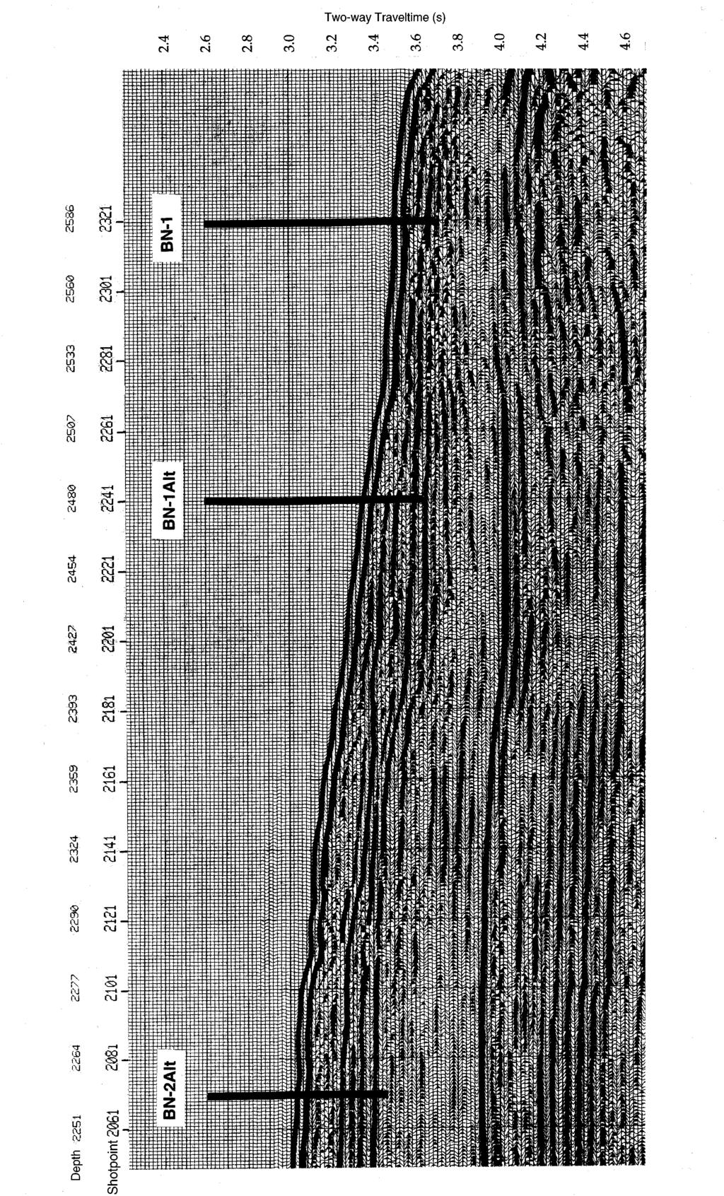
18 Page 18 LOGGING AND DRILLING STRATEGY Drilling Strategy Triple coring with the advanced hydraulic piston corer (APC) technique will be done at five sites in a transect from the margin of the Blake Plateau to the edge of the Blake Escarpment (Figs. 2, 3). Proposed Sites BN-1, BN-2Alt, BN-3, BN-4Alt, and BN-5Alt are primary sites and proposed Sites BN-1Alt and BN-4 are alternates. Use of the extended core barrel (XCB) is planned for all sites except for proposed Site BN-1. Double XCB coring is planned for proposed Sites BN-3 and BN-5Alt, whereas time limitations force us to plan drilling only single XCB holes at proposed Sites BN-2Alt and BN-4Alt. The safety panel has mandated that sites on Blake Nose be drilled up the depth transect from proposed Site BN-1 to proposed Site BN-5Alt. If time permits, we have permission to deepen Sites BN- 2, BN-3, and BN-4Alt XCB holes to 700 mbsf. In addition, proposed Site BN-5Alt may also be deepened to 700 mbsf should time permit, and there is a consensus to attempt to recover more of the Aptian-Alpian section. Alternatively, we may choose to drill an alternate site (BN-4 or BN-1Alt) should time permit at the end of the leg. Boreholes will be located along an existing, high-quality multichannel line that is crossed by a dense web of single-channel and 3.5-kHz lines. Seismic interpretations are supported by a series of JOIDES, USGS, and DSDP boreholes as well as observations from submersibles. The boreholes are intended to penetrate between 170 to 600 m of nannofossil ooze of Eocene, Paleocene, Maastrichtian, Campanian, and Aptian Albian age. All holes will extend below Reflector Purple, which is identified as basal Campanian in Hole 390A. All holes should penetrate middle to lower Eocene oozes and Paleocene and Maastrichtian Albian strata. Drilling at proposed Sites BN-2Alt and BN-3 has a high probability of recovering a complete K/T boundary sequence because these boreholes will penetrate the most stratigraphically complete sequences, where the upper Paleocene to Maastrichtian section is about 300 m thick. The drilling strategy is intended to recover a depth transect in pre-eocene strata that approaches the depth-resolution possible in upper Pleistocene piston core transects (e.g., Slowey and Curry, 1987, 1992; Lynch-Stieglitz et al., 1994). This will ensure a complete
19 Page 19 >1300-m depth transect from 1200 to 2500 mbsl in the Paleocene middle Eocene and bathyal Barremian basal Albian. The K/P boundary will be recovered in at least four of the five sites and will permit studies of sedimentation of the boundary beds across a depth transect. Triple APC coring will ensure nearly 100% recovery of the sedimentary section in the uppermost 160 m of each site. There is no evidence from previous drilling or from existing seismic records for appreciable hydrocarbons in the slope sediments proposed for drilling. It is unlikely that there are mobile hydrocarbons of Early Cretaceous or younger age on the Blake Nose. The sediments have never been deeply buried to depths sufficient for hydrocarbon maturation. It is possible that hydrocarbons may exist in the limestones below the pelagic drape of Barremian to Eocene sediments, but the proposed drilling will not penetrate these limestones except during redrilling of Site 390 (proposed Site BN-1). Truncation of the Albian Barremian clinoforms by the middle Cretaceous unconformity (Reflector Purple) could represent a stratigraphic trap. However, there is no evidence of hydrocarbons below this unconformity at Site 390. In addition, there are no obvious cross-strata reflectors that could represent trapped hydrocarbons within the sedimentary section proposed for drilling. A complication to drilling in this area is the existence of cherts in the lower Eocene and upper Paleocene. Seven partly lithified layers of limestone and chert were encountered in Hole 390A near the edge of the Blake Plateau. The layers are all about 5 cm thick or less and consist of irregularly replaced carbonates in a 30-m-thick interval of nannofossil ooze. Once through this section, the lower Paleocene through upper Aptian section is entirely ooze at Site 390. The Blake Nose is covered with a thin layer of phosphorite sand that rests on an erosion surface of late Paleogene or early Neogene age. Erosion has truncated the Paleogene section to varying degrees, particularly at the landward end of the transect (toward proposed Site BN-5Alt). Therefore, it is not necessary to recover the core top in good condition to meet the paleoceanographic objectives of the leg. However, we will attempt to piston core surficial sediments, if possible. In the event that the phosphorite damages the drilling tools or slows drilling operations, we will wash the phosphorite away prior to cutting our first APC core.
20 Page 20 Logging Plan Logging data will be important to achieve the objectives of this proposed leg. Logging will enhance site-to-site correlation, which is critical for reconstructing hydrography. Unfortunately, logging is typically restricted to parts of the hole more than m below seafloor (mbsf). Consequently, intersite correlation in the Eocene portion of the record will rely on logs generated from the recovered cores. Only holes deeper than 400 m will be logged, and these holes will be logged with the triple combination (triple-combo) tool string, Formation MicroScanner (FMS), and geological high-sensitivity magnetic tool (GHMT) strings. The triple-combo provides measurements of porosity, density, and electrical resistivity that will be used to describe the lithology, sedimentary fabric, degree of lithification, and fluid composition. The FMS tool string produces electrical resistivity images of the wall of the hole that can be used to study the orientation and structure of bedding, diagenetic features, fractures and sonic velocity. The GHMT provides continuous measurements of magnetic susceptibility and may provide a magnetic reversal stratigraphy if the magnetization of the sediments is sufficiently strong. Sampling Strategy One of the primary objectives of Leg 171B is to reconstruct water column structure, sea surface temperature, and bottom water chemistry at high temporal resolution. We hope to sample at ~3-5 ky resolution to obtain records of biological and physical oceanography at temporal resolutions used routinely in studies of the late Neogene. High resolution sampling in the Cretaceous and Paleogene will provide some of the first histories of the ancient oceans at a resolution similar to that frequently obtained from Pleistocene sediments and will facilitate comparison of the oceanographic dynamics of these time periods. In contrast to Neogene sections in which multiple APC cores are easily obtained because they are close to the seafloor, at some sites we may only be able to retrieve one copy of these Paleogene/Cretaceous sections since we must obtain these sections in a transect across a range of water depths.
21 Page 21 Given low regional sedimentation rates in the Cretaceous and Paleogene (1-3 cm/ky), the high temporal-resolution sampling required, and the operational reality of obtaining these deeply- buried sections across a transect of water depths indicates that in special circumstances we may need to exceed JOIDES sampling policy both in sample density and volume to achieve the primary paleoceanography, paleoclimatic, and paloemagnetic cruise objectives. Sampling of π or more of the core volume at specific levels may occasionally be required to achieve cruise objectives in instances even where only one hole or interval exists; however, no such samples will be taken without the express consent of both co-chiefs and the curatorial representative. This may be necessary even in instances where we are able to produce composite sections from multiple holes (to obtain the most continuous and undisturbed sequence). Sample volumes must be large enough to ensure adequate numbers of planktic and benthic foraminifers for biostratigraphic and stable isotope/trace element studies and will depend on exact nature of sediment recovered. This is not meant as a blanket statement for heavy sampling of all cores. In fact, every effort will be made to stay within sample guidelines by first attempting to assemble consortia of scientists to develop plans to attack these problems with the most efficient use of samples and/or by encouraging scientists to work on time slices or a subset of sites (as high resolution sampling of all core at all sites will result in an unreasonably large number of samples to be analyzed by any individual scientist for the scientific results). These sample will be taken during a post-cruise sampling party. Low resolution sampling will be carried out on board ship to conduct shipboard description/characterization, to facilitate pilot studies, to identify sections requiring highresolution post-cruise sampling, and to provide samples for studies which do not require a high temporal resolution.
22 Page 22 Critical boundary sampling: We expect that critical boundaries will be recovered in most or all of the holes drilled during this leg. All K-P and P-E boundary cores will be treated as critical intervals, subject to appropriate ODP policies and procedures. No samples will be removed from an interval within 3 m above or below the boundary until a consortium of interested scientists has formulated a detailed sampling plan, except for studies aimed at characterizing the interval (including smear slides and toothpick paleontological samples), or for pre-approved studies of the ephemeral properties deemed essential to K-P investigation. PROPOSED SITES Primary Sites (by order of drilling) Proposed Site BN-1 Proposed Site BN-1 is a reoccupation of Site 390. The principle objectives are to recover a sequence of Eocene though Campanian strata from deep water that can be compared with age-equivalent, but more expanded, sections at shallower water depths. In particular, the middle Eocene and lower Paleocene Maastrichtian are thick enough to permit high-resolution studies of Eocene paleoceanography and the nature of the K/P boundary event. About 200 m of sediment was recovered at Site 390, including 160 m of pelagic sediment that ranges in age from middle Eocene(?) to Barremian and 40 m of Barremian oolitic limestone. The pelagic sediments were entirely stiff to soupy nannofossil ooze with the exception of seven 5-cm-thick limestone and chert stringers encountered in the 30-m-thick lower Eocene and upper Paleocene sections. Eocene sediments comprise about 75 m of the cored section whereas the Paleocene (35 m), Maastrichtian (28 m), Campanian (2 m), and Barremian to lower Albian pelagic sediments (20 m) make up the remainder. During rotary core barrel (RCB) drilling of Hole 390A, coring penetrated about 50 m/hr except during drilling through the cherts, when the drilling rate dropped to about 20 m/hr.
23 Page 23 Proposed Site BN-1 is included mainly to increase the total depth range of the transect (to about 1371 m total water-depth range) and recover sediments deposited well within the Paleogene equivalent of modern upper deep water. Further, because Site 390 was rotary cored, the existing core is useless for high-resolution paleoceanography. This is a good site for recovering a moderately thick and well-preserved Eocene Paleocene section and for estimating the chemistry of upper deep water. However, the Cretaceous sequence is too condensed to be of much use for paleoceanography. The Mesozoic section should be of interest to sedimentologists interested in the control of water depth on sedimentation at the K/P boundary and processes of sedimentation (e.g., tying expanded sections at proposed Site BN-3 into the more condensed intervals at proposed Site BN-1). Proposed Site BN-2Alt Proposed Site BN-2Alt is located in 2257 m water depth. The site is located to take advantage of an unusually thick sequence of upper Paleocene(?) strata. At this location, the depth to Reflector Purple is about 400 m, primarily because of an unusually expanded section above Reflector Green (lower/upper Paleocene) and below Reflector Red (Paleocene/Eocene Boundary). The upper Paleocene is probably about 200 m thick at this site and the lower Paleocene Campanian section (between Reflectors Green and Purple) is about 75 m thick. The sediment packages between the other reflectors have similar thicknesses to their equivalents at Site 390. This is a high-priority site because it represents an expanded section of Paleocene Cretaceous sediments that are ideal as a deep-water end-member of the depth transect. The expanded section should help considerably in refining Paleocene and Eocene stratigraphy and paleoceanography because the best available low-latitude sites (such as DSDP Sites 577 and 384 and ODP Site 758) are comparatively condensed. The Aptian and older Cretaceous section is also a good end-member for a thermocline intermediate water depth transect in the Early Cretaceous. In addition, recovery at the the site will most likely include a complete K/P boundary with well-preserved microfossils. Drilling is proposed to about 600 mbsf to recover 400 m of middle Cretaceous Eocene sediments and 200 m of Lower Cretaceous sediments. Proposed Site BN-3
24 Page 24 Proposed Site BN-3 is located at shotpoint 1821 on MCS Line TD-5. It is similar to proposed Site BN-2Alt in terms of the thickness of the sediment packages between all the reflectors. As at Site BN-2Alt, the middle Eocene is about 75 m thick and overlies a 50- m section of lower Eocene to uppermost Paleocene (Reflector Orange to Reflector Red). The middle Paleocene is nearly 200 m thick (above Reflector Green) and overlies a 100-m-thick drape of lower Paleocene to Campanian strata (above Reflector Purple). The site is located at the intersection of the Glomar Challenger SCS line and MCS Line TD-5 at about 1972-m water depth. The section below Reflector Purple consists of 370 m of Lower Cretaceous(?) deposits. The middle Cretaceous represents the distal upper package of clinoforms that overlaps the pre-barremian(?) reef about 40 km to the southwest and can be traced updip to deposits below proposed Site BN-4. Coring is proposed to a depth of about 600 mbsf to recover the Paleogene and part of the Lower Cretaceous sections. Proposed Site BN-3 is about 300 m shallower than proposed Site BN-2Alt so both sites add to the resolution of the depth transect. Further, both proposed Sites BN-2Alt and BN-3 penetrate a thick section of Paleocene sediments, which should provide a fairly high-resolution, well preserved, sedimentary sequence that is singularly lacking in existing ODP/DSDP holes that penetrate this paleoclimate. Recovery at proposed Site BN-3 should include a well-preserved K/P boundary interval and expanded Aptian to older Cretaceous sequence. The site could be used as an alternate for proposed Site BN- 2Alt, but it would also serve as a site at intermediate depth between proposed Sites BN- 4 and BN-2Alt, where it improves the likelihood of correlating accurately between shallower and deeper sites and increases the probability of recovering a complete section of the Lower Cretaceous strata. Proposed Site BN-4Alt Proposed Site BN-4Alt is an alternate to proposed Site BN-4. The proposed site is located on shotpoint 1461 at a water depth of 1652 m. The objectives are similar to those for proposed Site BN-3, but the site would enable recovery of a slightly thicker section (~600 m) at a deeper water depth than at proposed Site BN-4. Recovery of a more expanded section above Reflector Purple than at proposed Site BN-4 would be at the expense of about 100 m of section below this reflector. Proposed Site BN-5Alt Proposed Site BN-5Alt is located on shotpoint 1241 on MCS Line TD-5 at a water
25 Page 25 depth of 1293 m. Proposed Site BN-5Alt would core about 100 m of Oligocene and younger strata, 200 m of Eocene to Upper Cretaceous(?) deposits, and 150 m of Lower Cretaceous deposits for a total penetration of about 450 m. Proposed Site BN-5Alt is included because it is the shallowest site that is likely to have a good Cenozoic section. At 1293 m depth, proposed Site BN-5Alt is well within modern intermediate water and hence is a good end-member for paleoceanographic studies. The site probably lacks a K/P boundary section, or it is very condensed relative to proposed Sites BN-2Alt, BN-3, and BN-4. However, recovery should include an Eocene to upper Paleocene section similar to the deeper sites as well as a shallow-water, endmember Lower Cretaceous section. Hence, this is a desirable site primarily because it expands the total depth range of the transect and increases the probability of reconstructing the vertical hydrographic structure from the late Paleocene to middle Eocene and in the Early Cretaceous. Correlation to proposed Site BN-2Alt will permit a depth transect of about 900 m between proposed Sites BN-5Alt and BN-2Alt, where the sections are expanded compared to that at proposed Site BN-1. Alternate Sites Proposed Site BN-1Alt Proposed Site BN-1Alt would allow recovery of a thicker section than at proposed Site BN-1 (400 m compared to ~170 m) at a slightly shallower depth (2480 mbsf). Nearly all the increased thickness would be in a more expanded Paleocene Eocene section. The site is located at shotpoint 2241 on MCS Line TD-5. This site is proposed as an alternate to proposed Site BN-1. Proposed Site BN-4 Proposed Site BN-4 lies at a water depth of 1410 m where about 200 m of upper Paleocene to Eocene strata over about 100 m of Campanian to lower Paleocene deposits are apparently preserved. Reflector Purple is underlain by about 250 m of deposits that appear to correlate with the seismic package that lies between Reflectors Blue and Purple at proposed Site BN-3. These are most likely Barremian to pre-lower Albian nannofossil ooze and clay similar to sediments recovered from the equivalent interval at Site 390. Coring will penetrate about 250 m below Reflector Purple for a total recovery of about
26 Page m of section. Proposed Site BN-4 is ~560 m shallower than proposed Site BN-3 and more than 800 m shallower than proposed Site BN-2Alt and should contain a record of the Paleogene equivalent of modern lower intermediate water. This is a critical site primarily because it provides the best shallow-water end-member for the depth transect through Paleocene and Lower Cretaceous strata. In addition, recovery at the site should include a K/P boundary section.
27 Page 27 REFERENCES Alvarez, W., et al., Proximal impact deposits at the Cretaceous-Tertiary boundary in the Gulf of Mexico: reinterpreting DSDP Sites 536 and 540. Geol. Soc. Amer. Abstracts, A420. (Abstract) Axelrod, D.,1984. An interpretation of Cretaceous and Tertiary biota in polar regions. Palaeogeog. Palaeoclim. Palaeoecol., 45: Barrera, E., and Huber, B., Evolution of Antarctic waters during the Maastrichtian: foraminifer oxygen and carbon isotope ratios, Leg 113. In Barker, P.F., Kennett, J.P., et al., Proc. ODP, Sci. Results, 113: College Station, TX (Ocean Drilling Program), , Paleogene and early Neogene oceanography of the Southern Indian Ocean: Leg 119 foraminifer stable isotope results. In Barron, J., Larsen, B., et al., Proc. ODP, Sci. Results, 119: College Station, TX (Ocean Drilling Program), Barron, E.A., and Washington, W.M., The atmospheric circulation during warm geologic periods: is the equator-to-pole surface temperature gradient the controlling factor. Geology, 10: Benson, W.E., and Sheridan, R.E., et al., Init. Repts. DSDP, 44: Washington (U.S. Govt. Printing Office). Berger, W.H., Kroenke, L.W., Mayer, L.A., et al., Proc. ODP, Sci. Results, 130: College Station, TX (Ocean Drilling Program). Berner, R.A., Atmospheric carbon dioxide over the Phanerozoic time. Science, 249: Boyle, E.A., Quaternary deepwater paleoceanography. Science, 249: Boyle, E.A., and Keigwin, L.D., Deep circulation of the Atlantic during the last 150,000 years, geochemical evidence. Science, 218: Charles, C., and Fairbanks, R., Evidence from Southern Ocean sediments for the effect of North Atlantic deep-water flux on climate. Nature, 355: Corfield, R., and Norris, R., Deep water circulation in the Paleocene ocean. In Knox, R.W., Corfield, R.M., Dunay, R.E. (Eds.), Correlation of the early Paleogene in Northwest Europe. London Geol. Soc. Spec. Publ., 101: Covey, C., and Barron, E., The role of ocean heat transport in climate change. Earth Science Reviews, 24: Curry, W.B., Duplessy, J.-C., Labeyrie, L.D., and Shackleton, N.J., Changes in the distribution of δ 13 C of deepwater PCO 2 between the last glaciation and the Holovcene. Paleoceanography, 3: Curry, W.B., and Lohmann, G.P., Late Quaternary sedimentation at the Sierra Leone Rise (eastern equatorial Atlantic Ocean). Marine Geology, 70: Curry, W.B., Cullen, J.L., and Backman, J., Carbonate accumulation in the Indian Ocean during the Pliocene: evidence for a change in productivity and preservation at about 2.4 Ma. In Duncan, R.A., Backman, J., Peterson, L.C., et.al., Proc. ODP, Sci. Results, 115: College Station, TX (Ocean Drilling Program),
28 Page 28 Dawson, M., West., R., Langston, W., and Hutchinson, J., Paleogene terrestrial vertebrates: northernmost occurrence, Ellesmere Island, Canada. Science, 192: Ehrendorfer, T.,W., Late Cretaceous (Maastrichtian) Calcareous nannoplankton biogeography [Ph.D. thesis]. Woods Hole Oceanographic Institution, WHOI Farrell, J.W., and Prell, W., Pacific CaCO 3 preservation and δ 18 O since 4 Ma: paleoceanic and paleoclimatic implications. Paleoceanography, 6: Gradstein, F., Bukry, D., Habib, D., Renz, O, Roth, P., Schimdt, R., Weaver, F., and Wind, F., Biostratigraphic summary of DSDP Leg 44: Western North Atlantic Ocean. In Benson, W. E., Sheridan, R.E., et al., Init. Repts. DSDP, 44: Washington (U.S. Govt. Printing Office), Hildebrand, A., and Boynton, W., Proximal Cretaceous-Tertiary boundary impact deposits in the Caribbean. Science, 248: Hutchinson, D.R., Poag, C.W., and Popenoe, P. in press. Geophysical database of the East Coast of the United States: Southern Atlantic margin stratigraphy and velocity from multichannel seismic profiles. USGS Open-File Report, Kennett, J., and Stott, L.D., Proteus and proto-oceanus: Paleogene oceans as revealed from Antarctic stable isotope results. In Barker, P.F., Kennett, J.P., et al., Proc. ODP, Sci. Results, 113: Washington (U.S. Govt. Printing Office), Lynch-Stieglitz, J., Fairbanks, R., and Charles, C., Glacial-interglacial history of Antarctic Intermediate Water: relative strengths of Antarctic versus Indian Ocean sources. Paleoceanography, 9:7 30. Margolis, S., et al., Tektite glass from the Cretaceous-Tertiary boundary, proximal to the proposed impact crater in northern Yucatan. GS. Abstr., A421. (Abstract) Miller, K., Janecek, T., Katz, M., and Keil, D., Abyssal circulation and benthic foraminiferal changes near the Paleocene/Eocene boundary. Paleoceanography, 2: Oppo, D.W., and Rosenthal, Y., Cd/Ca changes in a deep Cape Basin core over the past 730,000 years: response of circumpolar deepwater variability to Northern Hemisphere ice sheet melting? Paleoceanography, 9: Pak, D., and Miller, K.G., Paleocene to Eocene benthic foraminiferal isotopes and assemblages: implications for deep-water circulation. Paleoceanography, 7: Peterson et al., Cenozoic carbonate accumulation and compensation depth changes in the Indian Ocean. In Duncan, R.A., Rea, D.K., von Rad, U., and Weissel, J.K. (Eds.), Synthesis of Results from Scientific Drilling in the Indian Ocean. Geophy. Monogr., Am. Geophys. Union, 70: [\2-9-95] Popp, B.N., Takigiku, Hayes, J., Louda, J.W., and Baker, E.W., The post Paleozoic chronology and mechanism of C 13 depletion in primary marine organic matter. Amer. Jour. Sci., 289: Rea, D., Zachos, J., Owen, R., and Gingerich, P., Global change at the Paleocene/Eocene boundary: climatic consequences of tectonic events. Palaeogeog. Palaeoclim. Palaeoecol., 79:
29 Page 29 Savin, S., The history of the Earth's temperature during the past 100 million years. Ann. Rev. Earth Planet. Sci., 5: Shackelton, N.J., and Boersma, A., The climate of the Eocene ocean. Journal of the Geological Society of London, 138: Sigurdsson, H., Bont, M., Pradel, Ph., and D Hondt, S., 1991a. Geochemical constraints on source region of Cretaceous/Tertiary impact glasses. Nature, 353: Sigurdsson, H., D Hondt, S., Arthur, M., Bralower, T., Zachos, J., van Fossen, M., and Channell, J., 1991b. Glass from the Cretaceous-Tertiary boundary in Haiti. Nature, 349: Slowey, N., and Curry, W., Structure of the glacial thermocline at Little Bahama Bank. Nature, 327: Slowey, N., and Curry, W., Enhanced ventilation of the North Atlantic subtropical gyre thermocline during the last glaciation. Nature, 358: Stott, L., and Kennett, J., New constraints on early Tertiary paleoproductivity from carbon isotopes in foraminifera. Nature, 350: Stott, L.D., and Zachos, J.P., Paleogene paleoceanography workshop report. JOI- USSAC, Lake Arrowhead, CA, Jan. 4 6, Streeter, S.S., and Shackleton, N.J., Paleocirculation of the deep North Atlantic: 150,000 year record of benthic foraminifera and oxygen-18. Science, 203: Woodruff, F., and Savin, S.M., Miocene deep-water oceanography. Paleoceanography, 4: Wright, J.D., Miller, K.G., and Fairbanks, R.G., Early and middle Miocene stable isotopes: implications for deep-water circulation and climate. Paleoceanography, 7: Zachos, J., Rea, D., Sieto, K., Nomura, R., and Nitsuma, N., Paleogene and early Neogene deep water paleoceanography of the Indian Ocean as determined from benthic foraminifer stable carbon and oxygen isotope records. Geophysical Monograph, 70: Zachos, J. C., Stott, L.D., and Lohmann, K.C., Evolution of early Cenozoic marine temperatures. Paleoceanography, 9:
30 Page 30 SITE TIME ESTIMATE TABLE Site Latitude, longitude Water depth (mbsl) Penetration (mbsf) Operations 10.5-kt transit (days) Coring (days) Log (days) Total (days) Transit, Barbados to BN BN-1 (DSDP Site 390) BN-2Alt BN-3 BN-4Alt BH-5Alt N W N W N W N W N W Hole A: APC 160 m, OR, HF Hole B: APC 160 m Hole C: APC 160 m Hole A: APC 160 m, OR, HF, XCB 600 m, log Hole B: APC 160 m Hole C: APC 16 0 m Hole A: APC 160 m, OR, HF, XCB 600 m, log Hole B: APC 160 m Hole C: APC 160 m Hole A: APC 160 m, OR, HF, XCB 500 m, log Hole B: APC 160 m Hole C: APC 160 m Hole A: APC 160 m, OR, HF, XCB 450 m, log Hole B: APC 160 m, XCB 450 m Hole C: APC 160 m Transit BN-5ALT to Charleston, SC 1.0 Estimated time Available time Alternate sites BN-1Alt N W Hole A: APC 160 m, OR, HF, XCB 400 m, log Hole B: APC 160 m, XCB 400 m Hole C: APC 160 m, XCB 400 m BN N W Hole A: APC 160 m, OR, HF, XCB 550 m, log Hole B: APC 160 m, XCB 550 m Hole C: APC 160 m, XCB 550 m *HF = temperature measurement; OR = core orientation; log = triple-combo, FMS, and GHMT tool strings.
31 Page 31 FIGURE CAPTIONS Figure 1. Location of ODP Leg 171B Blake Nose paleoceanographic drilling transect. Figure 2. Location of Blake Nose, Western North Atlantic. Insert shows proposed drill sites and seismic lines shown in Figures 3 (dashed line) and 5 (shaded line). Figure 3. Schematic seismic interpretation of MCS Line TD-5 across Blake Nose showing the major reflectors, their interpreted ages, and proposed drill sites (primary sites = bold lines; alternate sites = thin lines). Our interpreted ages of reflectors are shown in parentheses and age interpretations of Hutchinson et al. (in press) are shown in square brackets. Numbers identifying various reflectors are those interpretations of Hutchison et al. and correspond to numbers shown on Figure 4. Location of seismic line is shown in Figure 2. Figure 4. Interpretation of MCS Line TD-5 from the Leg 44 scientific party. Note that this interpretation suggests the presence of a substantial thickness of mid- and Upper Cretaceous pelagic/hemipelagic sediments on Blake Nose. Figure 5. Portion of seismic Line TD-5UW showing the tie to DSDP Site 390 interpreted by Hutchinson et al. (in press). This interpretation has traced seismic units [70] and [80] at Site 390 into systematically deeper levels of the seismic profile at shotpoint 2101 than we would. Location of seismic line is shown in Figure 2, and units identified on Figure 3.

32 ODP Leg 171B, Blake Nose paleoceanographic transect North America Atlantic Ocean Blake Nose transect Blake-Bahama Outer Ridge
33
34

35
36
37 Page 32 Site: BN-1 (DSDP Site 390) Priority: 1 Position: 'N, 'W Water depth: 2586 m Sediment thickness: >3000 m Total penetration: 160 mbsf Seismic coverage: Glomar Challenger, Eastward 80-8 (1980); site located at shotpoint 2321 on MCS Line TD-5. Objectives: Determine history of Paleogene and Cretaceous water chemistry, carbonate productivity, and deep-water and surface temperature as well as evolutionary history of pelagic microfossils. Deep end-member of the depth transect. Drilling program: 1. APC coring to 160 mbsf (oriented): Hole A. 2. Holes B and C cored to 160 mbsf by unoriented APC. Logging and downhole: Adara temperature measurements and core orientation on A hole. Nature of rock anticipated: Nannofossil-foraminifer ooze, cherty limestone, calcareous clay.
38
39 Page 33 Site: BN-2Alt Priority:1 Position: 'N, 'W Water depth: 2257 m Sediment thickness: >3000 m Seismic coverage: Glomar Challenger, Gloria Farnella 1987 SCS Line 18, Gilliss Line 26, Eastward 80-8; located at shotpoint 2071 on MCS Line TD-5UW. Objectives: Determine history of Paleogene and Cretaceous water chemistry, carbonate productivity, and deep-water and surface temperature as well as evolutionary history of pelagic microfossils. Core Paleocene Eocene and Cretaceous Paleogene boundaries for paleoceanographic, evolutionary, and stratigraphic studies. Intermediate-deep point of depth transect. Drilling program: 1. APC coring to 160 mbsf or refusal (oriented): Hole A. 2. Holes B and C cored to 160 mbsf or refusal by unoriented APC. 3. Hole A deepened by XCB to 600 mbsf. Logging and downhole operations: Standard strings (triple-combo geophysical and FMS) and GHMT (magnetic susceptibility). Adara and WSTP temperature measurements may be run if time permits. Core orientation on at least the A hole. Nature of rock anticipated: Nannofossil-foraminifer ooze, chalk, cherty limestone, calcareous clay.
40 Page 34 Site: BN-3 Priority:1 Position: ', 'W Water depth: 1972 m Sediment thickness: >3000 m Seismic coverage:glomar Challenger, Eastward 80-8 (1980); located at shotpoint 1821 on MCS Line TD-5UW. Objectives: Determine history of Paleogene and Cretaceous water chemistry, carbonate productivity, and deep-water and surface temperature as well as evolutionary history of pelagic microfossils. Core Paleocene Eocene and Cretaceous Paleogene boundaries for paleoceanographic, evolutionary, and stratigraphic studies. Mid-point of depth transect. Drilling program: 1. APC coring to 160 mbsf or refusal (oriented): Hole A. 2. Holes B and C cored to 160 mbsf or refusal by unoriented APC. 3. Holes A and B deepened by XCB to 600 mbsf. XCB drilling of Hole B may be abandoned depending upon results of Hole A. Logging and downhole operations: Standard strings (triple-combo geophysical and FMS) and GHMT (magnetic susceptibility). Adara and WSTP temperature measurements may be run if time permits. Core orientation on at least the A hole. Nature of rock anticipated: Nannofossil-foraminifer ooze, chalk, cherty limestone, calcareous clay.

41
42 Page 35 Site: BN-4Alt Priority:1 Position: 'N, 'W Water depth: 1652 m Sediment thickness: >3000 m Seismic coverage: Gloria Farnella 1987 SCS Line 19, TD5UW (shotpoint 1461). Objectives: Determine history of Paleogene and Cretaceous water chemistry, carbonate productivity, and deep-water and surface temperature as well as evolutionary history of pelagic microfossils. Core Paleocene Eocene and Cretaceous Paleogene boundaries for paleoceanographic, evolutionary, and stratigraphic studies. Shallow intermediate point on depth transect. Drilling program: 1. APC coring to 160 mbsf or refusal (oriented): Hole A. 2. Holes B and C cored to 160 mbsf or refusal by unoriented APC. 3. Hole A deepened by XCB to 500 mbsf. Logging and downhole operations: Standard strings (triple-combo geophysical and FMS) and GHMT (magnetic susceptibility). Adara and WSTP temperature measurements may be run if time permits. Core orientation on at least the A hole. Nature of rock anticipated: Nannofossil-foraminifer ooze, chalk, cherty limestone, calcareous clay.

43
44 Page 36 Site: BN-5Alt Priority: 1 Position: 'N, 'W Water depth: 1293 m Sediment thickness: >3000 m Seismic coverage: Gloria Farnella 1987 SCS Line 20, TD5UW (shotpoint 1241). Objectives: Determine history of Paleogene and Cretaceous water chemistry, carbonate productivity, and deep-water and surface temperature as well as evolutionary history of pelagic microfossils. Core Paleocene Eocene and Cretaceous Paleogene boundaries for paleoceanographic, evolutionary, and stratigraphic studies. Shallow end-member of depth transect. May be deepened by up to 200 m if time permits to recover an expanded Aptian Albian section. Drilling program: 1. APC coring to 160 mbsf or refusal (oriented): Hole A. 2. Holes B and C cored to 160 mbsf or refusal by unoriented APC. 3. Holes A and B deepened by XCB to 450 mbsf. XCB drilling of Hole B may be abandoned depending upon results of Hole A. Logging and downhole operations: Standard strings (triple-combo geophysical and FMS) and GHMT (magnetic susceptibility). Adara and WSTP temperature measurements may be run if time permits. Core orientation on at least the A hole. Nature of rock anticipated: Nannofossil-foraminifer ooze, chalk, cherty limestone, calcareous clay.

45
Middle Eocene western north Atlantic biostratigraphy and environmental conditions
 Shari Hilding-Kronforst Shari Hilding-Kronforst is currently a Ph.D. candidate at Texas A&M University. Born in Illinois, she received a microscope at age 8 and dinosaur models at age 9. She completed
Lecture 18 Paleoceanography 2
 Lecture 18 Paleoceanography 2 May 26, 2010 Trend and Events Climatic evolution in Tertiary Overall drop of sea level General cooling (Figure 9-11) High latitude (deep-water) feature Two major step Middle
Integrated Ocean Drilling Program Expedition 316 Scientific Prospectus Addendum
 Integrated Ocean Drilling Program Expedition 316 Scientific Prospectus Addendum NanTroSEIZE Stage 1: NanTroSEIZE Shallow Megasplay and Frontal Thrusts Gaku Kimura Co-Chief Scientist Department of Earth
1. LEG 154 INTRODUCTION 1. Shipboard Scientific Party 2
 Curry, W.B., Shackleton, N.J., Richter, C, et al., 1995 Proceedings of the Ocean Drilling Program, Initial Reports, Vol. 154 1. LEG 154 INTRODUCTION 1 Shipboard Scientific Party 2 INTRODUCTION During the
Late Cretaceous biostratigraphy and adaptive radiation of the calcareous nannofossil genus Eiffellithus
 Ms Jamie Shamrock was born in Pennsylvania; she has earned already a B.A. in anthropology and a B.Sc. in geology. Ms. Shamrock is now going for her Master s degree at the University of Nebraska-Lincoln.
Seismic stratigraphy, some examples from Indian Ocean, interpretation of reflection data in interactive mode
 Seismic stratigraphy, some examples from Indian Ocean, interpretation of reflection data in interactive mode K. S. Krishna National Institute of Oceanography, Dona Paula, Goa-403 004. krishna@nio.org Seismic
Joides Resolution at Hong-Kong
 Report from Iván Hernández-Almeida, post-doc at the Oeschger Centre for Climate Change Research/Institute of Geography, University of Bern. Shipboard Micropaleontologist (radiolarian specialist) on IODP
Ch. 17 Review. Life in the Cretaceous
 Ch. 17 Review Life in the Cretaceous Diversification of diatoms, planktonic forams, calcareous nannoplankton Diversification of mobile predators (especially mollusks and teleost fishes) Origin of the angiosperms
Chemostratigraphic and Paleoenvironmental Analysis of Rudist Facies in Cretaceous Strata
 Chemostratigraphic and Paleoenvironmental Analysis of Rudist Facies in Cretaceous Strata Luis González, Hernan Santos (UPRM), Robert H. Goldstein, Alvin Bonilla STATUS: Long-term project near completion
IODP EXPEDITION 306: NORTH ATLANTIC CLIMATE II SITE U1314 SUMMARY
 IODP EXPEDITION 306: NORTH ATLANTIC CLIMATE II SITE U1314 SUMMARY Hole U1314A Latitude: 56 21.883'N, Longitude: 27 53.309'W Hole U1314B Latitude: 56 21.896'N, Longitude: 27 53.311'W Hole U1314C Latitude:
17. SEISMIC SEQUENCES OF CAPE BOJADOR, NORTHWEST AFRICA
 17. SEISMIC SEQUENCES OF CAPE BOJADOR, NORTHWEST AFRICA K. Hinz, Bundesanstalt fur Geowissenschaften und Rohstoffe. Stilleweg 2, D-3000 Hannover 51, Federal Republic of Germany ABSTRACT In the seismic
IODP drilling and core storage facilities
 4 IODP drilling and core storage facilities Neville Exon As the knowledge obtainable from ocean drilling is various and extensive, its end-users are similarly various and extensive. Scientific ocean drilling
Dr. Mark Leckie Scientist
 Wanted: Dead and Well-Preserved... Mohawk Guy and his Band of Neogene Planktic Foraminifer Friends Dr. Mark Leckie Scientist Introduction Dr. Mark Leckie has a passion for science and education with a
22. PETROLEUM-GENERATING POTENTIAL OF SEDIMENTS FROM LEG 44, DEEP SEA DRILLING PROJECT
 . PETROLEUM-GENERATING POTENTIAL OF SEDIMENTS FROM LEG, DEEP SEA DRILLING PROJECT J.W. Kendrick, A. Hood, and J.R. Castano, Shell Development Company, Houston, Texas ABSTRACT The abundance, type, and thermal
IODP Proposal Cover Sheet 914 -
 IODP Proposal Cover Sheet 914 - Full Brazilian Equatorial Margin Paleoceanography Received for: 2017-04-03 Title Cenozoic Paleoceanography of the Brazilian Equatorial Margin (PBEM) Proponents Luigi Jovane,
Longitude (E) Depth (m)
 Depth (m)") Table 1. Leg 194 proposed sites. Site Priority Line CDP Fig. Latitude (S) Longitude (E) Water Sediment Target Requested PPSP Depth (m) Thickness (m) Depth (m) Penetration (m) Approval CS-01A 1 MAR-29 4486
Table 1. Leg 194 proposed sites. Site Priority Line CDP Fig. Latitude (S) Longitude (E) Water Sediment Target Requested PPSP Depth (m) Thickness (m) Depth (m) Penetration (m) Approval CS-01A 1 MAR-29 4486
17. CARBONATE SEDIMENTARY ROCKS FROM THE WESTERN PACIFIC: LEG 7, DEEP SEA DRILLING PROJECT
 17. CARBONATE SEDIMENTARY ROCKS FROM THE WESTERN PACIFIC: LEG 7, DEEP SEA DRILLING PROJECT Ralph Moberly, Jr., Hawaii Institute of Geophysics, University of Hawaii, Honolulu, Hawaii and G. Ross Heath,
46. DATA REPORT: LATE PLIOCENE DISCOASTER ABUNDANCES FROM HOLE 806C 1
 Berger, W.H., Kroenke, L.W., Mayer, L.A., et al., 1993 Proceedings of the Ocean Drilling Program, Scientific Results, Vol. 130 46. : LATE PLIOCENE DISCOASTER ABUNDANCES FROM HOLE 806C 1 Jan Backman 2 and
APPENDIX C GEOLOGICAL CHANCE OF SUCCESS RYDER SCOTT COMPANY PETROLEUM CONSULTANTS
 APPENDIX C GEOLOGICAL CHANCE OF SUCCESS Page 2 The Geological Chance of Success is intended to evaluate the probability that a functioning petroleum system is in place for each prospective reservoir. The
Biostratigraphic and Lithostratigraphic Correlation of Sedimentary Strata in the Atlantic Coastal Plain
 Biostratigraphic and Lithostratigraphic Correlation of Sedimentary Strata in the Atlantic Coastal Plain Introduction to the Atlantic Coastal Plain (Please read this page prior to doing the lab) The Atlantic
Figure 1 Extensional and Transform Fault Interaction, Influence on the Upper Cretaceous Hydrocarbon System, Equatorial Margin, West Africa.
 Figure 1 Extensional and Transform Fault Interaction, Influence on the Upper Cretaceous Hydrocarbon System, Equatorial Margin, West Africa. Presented to the 10th PESGB/HGS Conference on Africa E + P September
MUHAMMAD S TAMANNAI, DOUGLAS WINSTONE, IAN DEIGHTON & PETER CONN, TGS Nopec Geological Products and Services, London, United Kingdom
 Geological and Geophysical Evaluation of Offshore Morondava Frontier Basin based on Satellite Gravity, Well and regional 2D Seismic Data Interpretation MUHAMMAD S TAMANNAI, DOUGLAS WINSTONE, IAN DEIGHTON
Evaluator: Eric Pyle James Madison University
 Building Core Knowledge Reconstructing Earth History Transforming Undergraduate Instruction by Bringing Ocean Drilling Science on Earth History and Global Climate Change into the Classroom This NSF-funded,
EGAS. Ministry of Petroleum
 EGAS Ministry of Petroleum EGAS Ministry of Petroleum About The Block Location: N. El Arish offshore block is located in the extreme eastern part of the Egypt s economic water border and bounded from the
OCEAN DRILLING PROGRAM LEG 171B PRELIMINARY REPORT BLAKE NOSE
 OCEAN DRILLING PROGRAM LEG 171B PRELIMINARY REPORT BLAKE NOSE Dr. Richard D. Norris Co-Chief Scientist, Leg 171B Department of Geology and Geophysics 360 Woods Hole Road Woods Hole Oceanographic Institute
EXTREME CLIMATES PPG (Second Report)
") EXTREME CLIMATES PPG (Second Report) March 99 Burkheim, Germany MEMBERS PRESENT Gerald Dickens, James Cook University (Australia) Jochen Erbacher, Bundesanstalt fuer Geowiss. und Rohstoffe (Germany) Timothy
EXTREME CLIMATES PPG (Second Report) March 99 Burkheim, Germany MEMBERS PRESENT Gerald Dickens, James Cook University (Australia) Jochen Erbacher, Bundesanstalt fuer Geowiss. und Rohstoffe (Germany) Timothy
3. The diagram below shows how scientists think some of Earth's continents were joined together in the geologic past.
 1. The map below shows the present-day locations of South America and Africa. Remains of Mesosaurus, an extinct freshwater reptile, have been found in similarly aged bedrock formed from lake sediments
EGAS. Ministry of Petroleum
 EGAS Ministry of Petroleum EGAS Ministry of Petroleum About The Block Location: N. Thekah offshore block is located at about 56 km to the north of the Mediterranean shore line, 85 km to the north west
11. DATA REPORT: RELATIVE ABUNDANCE
 Gersonde, R., Hodell, D.A., and Blum, P. (Eds.) Proceedings of the Ocean Drilling Program, Scientific Results Volume 177 11. DATA REPORT: RELATIVE ABUNDANCE AND RANGES OF SELECTED DIATOMS FROM PLIOCENE
Section 7. Reading the Geologic History of Your Community. What Do You See? Think About It. Investigate. Learning Outcomes
 Chapter 3 Minerals, Rocks, and Structures Section 7 Reading the Geologic History of Your Community What Do You See? Learning Outcomes In this section, you will Goals Text Learning Outcomes In this section,
Chapter 15 Millennial Oscillations in Climate
 Chapter 15 Millennial Oscillations in Climate This chapter includes millennial oscillations during glaciations, millennial oscillations during the last 8000 years, causes of millennial-scale oscillations,
Subduction Zone Conditions
 Summary Students investigate core samples obtained across a subduction zone off the east coast of Japan and compare the rock found in each drill hole. Learning Objectives Students will be able to: Use
A bit of background on carbonates. CaCO 3 (solid)
") A bit of background on carbonates CaCO 3 (solid) Organisms need both carbon dioxide and carbonate Kleypas et al 2005 The two pumps put CO 2 into the deep ocean The long term record of climate change Or:
A bit of background on carbonates CaCO 3 (solid) Organisms need both carbon dioxide and carbonate Kleypas et al 2005 The two pumps put CO 2 into the deep ocean The long term record of climate change Or:
SUPPLEMENTARY INFORMATION
 SUPPLEMENTARY INFORMATION DOI: 1.138/NGEO168 "Strength and geometry of the glacial Atlantic Meridional Overturning Circulation" S2 Map of core locations Core locations of the Holocene and LGM 231 / 23
Bahamian Dolomites. Occurrences in the Bahamas 2/25/2009. Platform Dolomites. Cretaceous Dolomite. San Salvador Little Bahama Bank.
 Bahamian Dolomites A Short Course VU March, 2009 Peter Swart University of Miami Occurrences in the Bahamas Platform Dolomites San Salvador Little Bahama Bank Bahamas Drilling Project Unda Clino Cretaceous
16. DATA REPORT: CARBONATE
 Prell, W.L., Wang, P., Blum, P., Rea, D.K., and Clemens, S.C. (Eds.) Proceedings of the Ocean Drilling Program, Scientific Results Volume 184 16. DATA REPORT: CARBONATE AND ORGANIC CARBON CONTENTS OF SEDIMENTS
Development of the Global Environment
 Development of the Global Environment G302: Spring 2004 A course focused on exploration of changes in the Earth system through geological history Simon C. Brassell Geological Sciences simon@indiana.edu
22. FLUCTUATIONS IN THE PAST RATES OF CARBONATE SOLUTION IN SITE 149: A COMPARISON WITH OTHER OCEAN BASINS AND AN INTERPRETATION OF THEIR SIGNIFICANCE
 . FLUCTUATIONS IN THE PAST RATES OF CARBONATE SOLUTION IN SITE : A COMPARISON WITH OTHER OCEAN BASINS AND AN INTERPRETATION OF THEIR SIGNIFICANCE Anthony T. S. Ramsay, Department of Geology, University
I. CALCIUM-CARBONATE AND SAND-FRACTION ANALYSIS OF CENOZOIC AND MESOZOIC SEDIMENTS FROM THE MOROCCAN BASIN
 I. CALCIUM-CARBONATE AND SAND-FRACTION ANALYSIS OF CENOZOIC AND MESOZOIC SEDIMENTS FROM THE MOROCCAN BASIN Marthe Melguen, Centre Océanologique de Bretagne, BP, 9 Brest Cedex, France INODUCTION As the
5. DATA REPORT: STABLE ISOTOPES
 Prell, W.L., Wang, P., Blum, P., Rea, D.K., and Clemens, S.C. (Eds.) Proceedings of the Ocean Drilling Program, Scientific Results Volume 84 5. DATA REPORT: STABLE ISOTOPES FROM SITES 47 AND 48 Xinrong
IODP Expedition 354: Bengal Fan Site U1451 Summary
 IODP Expedition 354: Bengal Fan Site U1451 Summary Background and Objectives Site U1451 is the easternmost of the seven-site Bengal fan transect and was the only one aimed to core the older portions of
Meandering Miocene Deep Sea Channel Systems Offshore Congo, West Africa
 Meandering Miocene Deep Sea Channel Systems Offshore Congo, West Africa S. Baer* (PGS), J. E. Comstock (PGS), K. Vrålstad (PGS), R. Borsato (PGS), M. Martin (PGS), J.P. Saba (SNPC), B. Débi-Obambé (SNPC)
*To whom correspondence should be addressed: FAX: (886) ;
 ;") DATA REPORT: CARBONATE AND ORGANIC CARBON CONTENTS OF SEDIMENTS FROM SITES 1143 AND 1146 IN THE SOUTH CHINA SEA Li-Wen Wang* and Hui-Ling Lin Institute of Marine Geology and Chemistry National Sun Yat-Sen
DATA REPORT: CARBONATE AND ORGANIC CARBON CONTENTS OF SEDIMENTS FROM SITES 1143 AND 1146 IN THE SOUTH CHINA SEA Li-Wen Wang* and Hui-Ling Lin Institute of Marine Geology and Chemistry National Sun Yat-Sen
Weissel, J., Peirce, J., Taylor, E., Alt, J., et al., 1991 Proceedings of the Ocean Drilling Program, Scientific Results, Vol. 121
 Weissel, J., Peirce, J., Taylor, E., Alt, J., et al., 1991 Proceedings of the Ocean Drilling Program, Scientific Results, Vol. 121 40. DATA REPORT: OXYGEN AND CARBON ISOTOPE RECORDS OF THE UPPER MAESTRICHTIAN
Chapter 1: Acoustic and elastic properties of calcareous sediments siliceous diagenetic front on the eastern U.S.
 1 Chapter 1: Acoustic and elastic properties of calcareous sediments siliceous diagenetic front on the eastern U.S. continental slope across a 1.1 Abstract The Ocean Drilling Program drilled Hole 904A
Lecture Outline Wednesday - Friday February 14-16, 2018
 Lecture Outline Wednesday - Friday February 14-16, 2018 Quiz 2 scheduled for Friday Feb 23 (Interlude B, Chapters 6,7) Questions? Chapter 6 Pages of the Past: Sedimentary Rocks Key Points for today Be
21. GEOCHEMICAL ANALYSIS OF SAMPLES FROM SITES 397 AND 398
 21. GEOCHEMICAL ANALYSIS OF SAMPLES FROM SITES 397 AND 398 Daniel B. Pearson, The Superior Company, Houston, Texas and Wallace G. Dow, Getty Company, Houston, Texas 1 INTRODUCTION Economic interest in
Geologic Time. Geologic Events
 Geologic Time Much of geology is focused on understanding Earth's history. The physical characteristics of rocks and minerals offer clues to the processes and conditions on and within Earth in the past.
Small area of the ocean that is partially surrounded by land. The Ocean Basins. Three Major Oceans. Three Major Oceans. What is a SEA?
 The Ocean Basins How Deep is the Ocean? 1 2 Three Major Oceans Three Major Oceans Pacific Atlantic the shallowest ocean (3.3km average depth) Indian second shallowest ocean (3.8km average depth) Pacific
Paleoclimate indicators
 Paleoclimate indicators Rock types as indicators of climate Accumulation of significant thicknesses of limestone and reef-bearing limestone is restricted to ~20º + - equator Gowganda tillite, Ontario
Climate and Environment
 Climate and Environment Oxygen Isotope Fractionation and Measuring Ancient Temperatures Oxygen Isotope Ratio Cycles Oxygen isotope ratio cycles are cyclical variations in the ratio of the mass of oxygen
Relinquishment Report Licence P1597
 Relinquishment Report Licence P1597 Valiant Causeway Limited, February 2013 1. Header Licence Number: P1597 Licence Round: 25 th Round Licence Type: Traditional Block Numbers: 206/5b and 207/1b Partners:
Questions and Topics
 Plate Tectonics and Continental Drift Questions and Topics 1. What are the theories of Plate Tectonics and Continental Drift? 2. What is the evidence that Continents move? 3. What are the forces that
Comment on: Cenozoic evolution of the eastern Danish North Sea by M. Huuse, H. Lykke-Andersen and O. Michelsen, [Marine Geology 177, 243^269]
![Comment on: Cenozoic evolution of the eastern Danish North Sea by M. Huuse, H. Lykke-Andersen and O. Michelsen, [Marine Geology 177, 243^269]](/thumbs/93/112023617.jpg "Comment on: Cenozoic evolution of the eastern Danish North Sea by M. Huuse, H. Lykke-Andersen and O. Michelsen, [Marine Geology 177, 243^269]") Marine Geology 186 (2002) 571^575 Discussion Comment on: Cenozoic evolution of the eastern Danish North Sea by M. Huuse, H. Lykke-Andersen and O. Michelsen, [Marine Geology 177, 243^269] P. Japsen, T.
Marine Geology 186 (2002) 571^575 Discussion Comment on: Cenozoic evolution of the eastern Danish North Sea by M. Huuse, H. Lykke-Andersen and O. Michelsen, [Marine Geology 177, 243^269] P. Japsen, T.
Orphan Basin, Offshore Newfoundland: New seismic data and hydrocarbon plays for a dormant Frontier Basin
 Orphan Basin, Offshore Newfoundland: New seismic data and hydrocarbon plays for a dormant Frontier Basin Jerry Smee* G&G Exploration Consulting, 301 400-3rd Avenue SW, Calgary, AB, T2P 4H2 Sam Nader, Paul
Exploration, Drilling & Production
 Nontechnical Guide to PETMOLEUM Geology, Exploration, Drilling & Production Third Edition Norman J. Hyne, Ph.D. Contents Preface *i Introduction 1 The Nature of Gas and Oil 1 Petroleum 1 The Chemistry
34. THE GEOLOGICAL AND GEOPHYSICAL SETTING NEAR SITE 462 1
 34. THE GEOLOGICAL AND GEOPHYSICAL SETTING NEAR SITE 462 L. K. Wipperman, 2 Hawaii Institute of Geophysics, University of Hawaii, Honolulu, Hawaii R. L. Larson, 3 Lamont-Doherty Geological Observatory
Figure 1. Locations of Sites 280 and 281.
 33. DETRITAL AND BIOGENIC SEDIMENT TRENDS AT DSDP SITES 280 AND 281, AND EVOLUTION OF MIDDLE CENOZOIC CURRENTS Monty A. Hampton, Geology Department, University of Rhode Island, Kingston, Rhode Island ABSTRACT
IRAQ. Target Exploration. Geodynamic Evolutions of The Sedimentary Basins of. This study is a major reference for Petroleum
 barr Target Exploration Target Exploration Geodynamic Evolutions of The Sedimentary Basins of IRAQ This study is a major reference for Petroleum Explorationists on the tectonics, stratigraphy, sedimentary
GLG101: What-To-Know List
 Exam 3, Page 1 GLG101: What-To-Know List (Derived from Before You Leave This Page Lists) This list is intended to guide your reading and to help you prepare for the online multiple-choice quizzes. Each
5. DATA REPORT: SURVEY OF DIATOMS SITES 1257 AND 1258: DEMERARA RISE, WESTERN ATLANTIC 1 IN OCEAN DRILLING PROGRAM LEG 207, INTRODUCTION AND METHODS
 Mosher, D.C., Erbacher, J., and Malone, M.J. (Eds.) Proceedings of the Ocean Drilling Program, Scientific Results Volume 207 5. DATA REPORT: SURVEY OF DIATOMS IN OCEAN DRILLING PROGRAM LEG 207, SITES 1257
Revised reservoir model for the Paleocene mounds of the Utsira High, North Sea, Norway John Wild (1) & Nowell Briedis (2)
 & Nowell Briedis (2)") Revised reservoir model for the Paleocene mounds of the Utsira High, North Sea, Norway John Wild (1) & Nowell Briedis (2) (1) Mobil North Sea LLC (2) Esso Exploration & Production Norway A/S (ExxonMobil
Revised reservoir model for the Paleocene mounds of the Utsira High, North Sea, Norway John Wild (1) & Nowell Briedis (2) (1) Mobil North Sea LLC (2) Esso Exploration & Production Norway A/S (ExxonMobil
Controls on clastic systems in the Angoche basin, Mozambique: tectonics, contourites and petroleum systems
 P2-2-13 Controls on clastic systems in the Angoche basin, Mozambique: tectonics, contourites and petroleum systems Eva Hollebeek, Olivia Osicki, Duplo Kornpihl Schlumberger, London, UK Introduction Offshore
Gas hydrate on the continental margin. Hitoshi Tomaru
 Gas hydrate on the continental margin Hitoshi Tomaru Department of Earth and Planetary Science, University of Tokyo 7-3-1 Hongo, Bunkyo-ku, Tokyo 113-0033, Japan E-mail: tomaru@eps.s.u-tokyo.ac.jp Tel:
11. OXYGEN AND CARBON ISOTOPIC VARIATION IN PLIOCENE BENTHIC FORAMINIFERS OF THE EQUATORIAL ATLANTIC 1
 Ruddiman, W., Sarnthein M., et al., 1989 Proceedings of the Ocean Drilling Program, Scientific Results, Vol. 108 11. OXYGEN AND CARBON ISOTOPIC VARIATION IN PLIOCENE BENTHIC FORAMINIFERS OF THE EQUATORIAL
Chapter 4 Implications of paleoceanography and paleoclimate
 Age ka / Chapter 4 Implications of paleoceanography and paleoclimate 4.1 Paleoclimate expression 4.2 Implications of paleocirculation and tectonics 4.3 Paleoenvironmental reconstruction MD05-2901 (Liu
Aptian/Albian Reservoir Development in the Jeanne d Arc Basin, Offshore Eastern Canada
 Aptian/Albian Reservoir Development in the Jeanne d Arc Basin, Offshore Eastern Canada Jonathan Marshall, Statoil Canada Ltd. Calgary, Alberta, Canada. jomars@statoil.com Introduction: The Jeanne d Arc
Where is all the water?
 Where is all the water? The distribution of water at the Earth's surface % of total Oceans 97.25 Ice caps and glaciers 2.05 Groundwater 0.68 Lakes 0.01 Soils 0.005 Atmosphere (as vapour) 0.001 Rivers 0.0001
Ship heave effects while drilling: observations from Legs 185 & 188
 Ship heave effects while drilling: observations from Legs 185 & 188 D. Goldberg 1, G. Myers 1, G. Guerin 1, D. Schroeder 2 and the Legs 185 & 188 scientific parties 1 Lamont-Doherty Earth Observatory,
Gas hydrate-related sedimentary pore pressure changes offshore Angola
 Gas hydrate-related sedimentary pore pressure changes offshore Angola Christian Berndt and Bedanta Goswami 1 National Oceanography Centre, Southampton, U.K. cbe@noc.soton.ac.uk, bedantag@gmail.com ABSTRACT
A Tectonostratigraphic History of Orphan Basin, Offshore Newfoundland, Canada
 A Tectonostratigraphic History of Orphan Basin, Offshore Newfoundland, Canada Lynn T. Dafoe*, Charlotte E. Keen, Graham L. Williams, and Sonya A. Dehler, Geological Survey of Canada, Dartmouth, NS Canada
Block 43B - Onshore Oman
 Block 43B - Onshore Oman SUMMARY Block 43B is an 11,967 km 2 area located along the coastal area of Oman north of the Hajar Mountains. This is an unexplored region, both geographically and stratigraphically.
Loess and dust. Jonathan A. Holmes Environmental Change Research Centre
 Loess and dust Jonathan A. Holmes Environmental Change Research Centre Why is dust important? Mineral dust is an important constituent of the solid load in Earth's atmosphere, the total atmospheric aerosol
IODP Science Evaluation Panel: Guidelines and Rationale for Site Characterization Data (Revised: August 2013)
") Site Characterization Data Guidelines IODP Science Evaluation Panel: Guidelines and Rationale for Site Characterization Data (Revised: August 2013) This document outlines the method and rationale for data
Site Characterization Data Guidelines IODP Science Evaluation Panel: Guidelines and Rationale for Site Characterization Data (Revised: August 2013) This document outlines the method and rationale for data
Paleoceanography II Telluric Effects on Oceanography
 Paleoceanography II Telluric Effects on Oceanography Geological Oceanography OCN 622 Gary McMurtry Telluric Effects Tellus = Earth Distribution of Continents at 100 Ma BP and Present Comparison of Earth
Expedition 320: Pacific Equatorial Age Transect (PEAT I) 25 April 2009
 25 April 2009") Expedition 320: Pacific Equatorial Age Transect (PEAT I) 25 April 2009 Site U1334 Summary Three holes were cored at Site U1334 (7º59.998 N, 131º58.408 W, 4799 m water depth), targeting the events bracketing
Expedition 320: Pacific Equatorial Age Transect (PEAT I) 25 April 2009 Site U1334 Summary Three holes were cored at Site U1334 (7º59.998 N, 131º58.408 W, 4799 m water depth), targeting the events bracketing
8. MAGNETIC FABRIC OF QUATERNARY, TERTIARY, AND CRETACEOUS SEDIMENTS FROM THE GOBAN SPUR, LEG 80: IMPLICATIONS FOR SEDIMENT TRANSPORT PROCESSES 1
 8. MAGNETIC FABRIC OF QUATERNARY, TERTIARY, AND CRETACEOUS SEDIMENTS FROM THE GOBAN SPUR, LEG 80: IMPLICATIONS FOR SEDIMENT TRANSPORT PROCESSES 1 E. A. Hailwood and S. L. Folami, Department of Oceanography,
Mesozoic Earth History
 Mesozoic Earth History The Mesozoic Era 251-66 MYA Breakup of Pangea Changes in air and oceanic currents Evolution of new terrestrial and marine life Opening of the Atlantic Ocean Basin Rocky Mountains
The Eocene Gir Formation of the Ghani and Ed Dib Fields, Eastern Libya - an example of "Virtual Core Study"
 The Eocene Gir Formation of the Ghani and Ed Dib Fields, Eastern Libya - an example of "Virtual Core Study" Henry Williams*, Suncor Energy Inc., Calgary, AB hwilliams@suncor.com Summary The Gir Formation
Chapter 2 Plate Tectonics and the Ocean Floor
 Chapter 2 Plate Tectonics and the Ocean Floor Matching. Match the term or person with the appropriate phrase. You may use each answer once, more than once or not at all. 1. hydrothermal vents A. convergent
Lower Skinner Valley Fill Sandstones: Attractive Exploration Targets on the Northeast Oklahoma Platform*
 Lower Skinner Valley Fill Sandstones: Attractive Exploration Targets on the Northeast Oklahoma Platform* By Jim Puckette 1 Search and Discovery Article #10050 (2003) *Adapted from presentation to Tulsa
Perspectives from Offshore Argentina & Uruguay
 Perspectives from Offshore Argentina & Uruguay A Prospectivity Overview Hannah Kearns October 2018 Introduction Argentina Offshore License Round 1 14 blocks Argentina North, 24 Austral-Malvinas Offshore
1. Introduction 2. Ocean circulation a) Temperature, salinity, density b) Thermohaline circulation c) Wind-driven surface currents d) Circulation and
 Temperature, salinity, density b) Thermohaline circulation c) Wind-driven surface currents d) Circulation and") 1. Introduction 2. Ocean circulation a) Temperature, salinity, density b) Thermohaline circulation c) Wind-driven surface currents d) Circulation and climate change e) Oceanic water residence times 3.
1. Introduction 2. Ocean circulation a) Temperature, salinity, density b) Thermohaline circulation c) Wind-driven surface currents d) Circulation and climate change e) Oceanic water residence times 3.
A comparison of structural styles and prospectivity along the Atlantic margin from Senegal to Benin. Peter Conn*, Ian Deighton* & Dario Chisari*
 A comparison of structural styles and prospectivity along the Atlantic margin from Senegal to Benin Overview Peter Conn*, Ian Deighton* & Dario Chisari* * TGS, Millbank House, Surbiton, UK, KT6 6AP The
Figure 1. Examples of vector displacement diagrams for two and three-plate systems.
 Figure 1. Examples of vector displacement diagrams for two and three-plate systems. Figure 2. Relationships between pole of rotation, great circles, ridge segments, small circles, transforms and fracture
Objectives. Vocabulary. Describe the geologic time scale. Distinguish among the following geologic time scale divisions: eon, era, period, and epoch.
 The Geologic Time Scale Objectives Describe the geologic time scale. Distinguish among the following geologic time scale divisions: eon, era, period, and epoch. Vocabulary geologic time scale eon era period
BALOCHISTAN FOLDBELT BASIN
 INTRODUCTION BALOCHISTAN FOLDBELT BASIN The Kharan-3 block is located in the Kharan Trough of Balochistan Basin. GEOLOGICAL SETTING The Balochistan Province is an Upper Cretaceous to Recent structurally
(Brown & Loucks, 2009)
") SECARB Phase 3, Task 15 Geological CO 2 Sequestration Capacity Estimate Offshore Northern Gulf of Mexico March 9, 2011 Prepared by David L. Carr Project Team: Cari Breton, GIS Analyst David L. Carr, Reservoir
SECARB Phase 3, Task 15 Geological CO 2 Sequestration Capacity Estimate Offshore Northern Gulf of Mexico March 9, 2011 Prepared by David L. Carr Project Team: Cari Breton, GIS Analyst David L. Carr, Reservoir
PLATE TECTONICS THEORY
 PLATE TECTONICS THEORY Continental drift Sea floor spreading CONTINENTAL DRIFT CONTINENTAL DRIFT 1. The fitness of continents and Continental Reconstruction Earth ~200 million years ago 1.1 Geometrical
Maturity Modeling of Gomin and South Gomin fields Southern Pattani Basin, Gulf of Thailand
 Maturity Modeling of Gomin and South Gomin fields Southern Pattani Basin, Gulf of Thailand Patinya Jaithan Petroleum Geoscience Program, Department of Geology, Faculty of Science, Chulalongkorn University,
10. CARBON-CARBONATE CONTENT OF SEDIMENTS FROM THE WESTERN EQUATORIAL PACIFIC: LEG 7, GLOMAR CHALLENGER
 0. CARBON-CARBONATE CONTENT OF SEDIMENTS FROM THE WESTERN EQUATORIAL PACIFIC: LEG, GLOMAR CHALLENGER E. L. Geary, Scripps Institution of Oceanography, University of California, La Jolla, California A to
Chapter 2: Plate Tectonics: A Unifying Theory
 Chapter 2: Plate Tectonics: A Unifying Theory Chapter Outline 2.1 Introduction 2.2 Early Ideas About Continental Drift 2.3 What Is the Evidence for Continental Drift? 2.4 Features of the Seafloor 2.5 Earth
6. What has been the most effective erosive agent in the climate system? a. Water b. Ice c. Wind
 Multiple Choice. 1. Heinrich Events a. Show increased abundance of warm-water species of planktic foraminifera b. Show greater intensity since the last deglaciation c. Show increased accumulation of ice-rafted
G 3. AN ELECTRONIC JOURNAL OF THE EARTH SCIENCES Published by AGU and the Geochemical Society
 Geosystems G 3 AN ELECTRONIC JOURNAL OF THE EARTH SCIENCES Published by AGU and the Geochemical Society Forum Volume 2 January 9, 2001 Paper number 2000GC000131 ISSN: 1525-2027 On the fate of past gas:
The surface of the ocean floor is as varied as the land. The five major oceans, from largest to smallest, are
 11.1 Ocean Basins The surface of the ocean floor is as varied as the land. The five major oceans, from largest to smallest, are w the Pacific w the Atlantic w the Indian w the Southern w the Arctic The
Before Plate Tectonics: Theory of Continental Drift
 Before Plate Tectonics: Theory of Continental Drift Predecessor to modern plate tectonics Shape and fit of the continents was the initial evidence Snider-Pelligrini (1858) Taylor (1908) Wegner (1915) Fig.
Tutorial on Methane Hydrate. Presented by Ad Hoc Group on Methane Hydrate Research March 24, 2004
 Tutorial on Methane Hydrate Presented by Ad Hoc Group on Methane Hydrate Research March 24, 2004 Tutorial on Methane Hydrate What is it and how is it formed? Where is it found? How much may exist? Multi-National
Lab 7: Sedimentary Structures
 Name: Lab 7: Sedimentary Structures Sedimentary rocks account for a negligibly small fraction of Earth s mass, yet they are commonly encountered because the processes that form them are ubiquitous in the
Key Elements of the Petroleum Systems of the Rockall and Slyne-Erris Basins
 Key Elements of the Petroleum Systems of the Rockall and Slyne-Erris Basins Bandon Corrib Dooish Atlantic Ireland Conference, Dublin, 1 st - 2 nd November 2016 Rockall and Slyne-Erris Basins Only 11 exploration
SUPPLEMENTARY INFORMATION
 SUPPLEMENTARY INFORMATION Site Information: Table S1: Sites Modern Location Modern SST ( C) PO4(µM)-0m PO4(µM)-75m 130-806 0.5N, 159.5E 29.2 0.24 0.34 *(6) 154-925 4.5N, 43.5W 27.4 0.24 0.35 *(S35) 198-1208