Keywords: Geophysical survey, 1D resistivity sounding, VES cross section, groundwater explorations, Anjani and Jhiri River, Maharashtra, India
|
|
|
- Angelica Wilson
- 5 years ago
- Views:
Transcription


1 Journal of Spatial Hydrology Vol.12, No.1 Fall D resistivity sounding geophysical survey by using Schlumberger electrode configuration method for groundwater explorations in catchment area of Anjani and Jhiri river, Northern Maharashtra (India) GOLEKAR R B 1, BARIDE M V*, PATIL S N 2 Abstract: The present paper focuses on groundwater exploration using scientific methods. The area decide for the study, Anjani and Jhiri river basin, which comes under hard rock terrain from Maharashtra province, India. In this regards to conduct the hydrogeological and hydrogeophysical survey to understand the groundwater condition in the area. The aquifer geometry in the study area has been interpreted by carrying out 1D resistivity sounding using the conventional four electrode resistivity meter. The resistivity measurements obtained in sounding have been interpreted by curve matching technique to calculate the layer parameters (resistivity and thickness) and subsequently to reconstruct the depth sections of the profiles. Based on the range of resistivity values, the weathered and fractured zones are interpreted. The contacts between certain saturated and dry formation zones having different resistivity values can be identified from the resistivity section. Keywords: Geophysical survey, 1D resistivity sounding, VES cross section, groundwater explorations, Anjani and Jhiri River, Maharashtra, India Introduction In arid and semi-arid regions, irrigation is the lifeline of agriculture and has assumed greater importance with induction of modern technology, particularly after the introduction of high yielding varieties of seeds, chemical fertilizers, pesticides, insecticides, etc. With the advent of green revolution, the groundwater use in agriculture has increased by a greater proportion as compared to surface water. As a result, water levels have declined significantly in some regions of the India (CGWB, 2009). The lowering of groundwater levels has resulted in reduction in individual well yield, growth in well population, failure of bore holes drying up of dug wells and increase in power consumption (Imtiyaz and Rao, 2008). Thus, the issue of availability and sustainability of safe groundwater is of great importance and calls for a scientific action plan to ensure water security in the region. Groundwater is often developed without proper understanding of its occurrence in time and space and is, therefore, endangered by over-exploitation and contamination. For that reason, groundwater management is the key to conflict the emerging problem of water security. Knowledge of water table depth is a crucial element in many hydrological investigations, including agricultural salinity management, landfill characterization, chemical seepage movement, and water supply studies (Buchanan and Triantafilis, 2009). There are several difficulties for development of groundwater resources in hard rock areas as broad and unpredictable variation of critical parameters (i.e. fractures, joints, porosity, etc), characterize the groundwater regime. Spatial variations of these characteristic parameters are recognized to, among other causes, to tectonic set-up and the degree of weathering of near surface rocks (Barker et al. 2001). These processes induce directly or indirectly secondary porosity in the hard rock s to a variable Department of Applied Geology, School of Environmental and Earth Sciences, North Maharashtra University, Jalgaon, (M.S.), India 2 Department of Applied Geology, School of Environmental and Earth Sciences, North Maharashtra University, Jalgaon, (M.S.), India * Department of Geology, Z.B. Patil College, Dhule (M.S.), India Corresponding author: Golekar R. B. ( ): rbgolekar@gmail.com
2 extent. As a result, the groundwater potential also varies significantly from place to place sometimes within a few meters and even within the same geological formations. Indian context the situation becomes all the more unstable due to negligible primary porosity and low permeability of host rocks restrict groundwater storage as well as movement, and also low rainfall, high evaporation and surface run-off limit recharge to the groundwater systems (Rangarajan and Athavale, 2000). Any change in rainfall patterns poses a serious threat to agriculture, and its impact on the country s economy and food security. Agriculture is adversely affected not only by an increase or decrease in the overall amount of rainfall, but also by shifts in the timing of the rainfall. The fertility of farmland as well as the stability of land resources depends upon the activities of the summer monsoon. Thus the economy of the farmers is closely attached to the good monsoon rain between June to September and it acts as a lifeline to the agricultural society. However basaltic areas, in particular, have shown that a systematic surface exploration succeeds in locating sites where high yielding wells may be drilled. Groundwater is a valuable natural source for several essential purposes such as public, industries and agricultural water supply. The demand of this natural resource is increasing in many folds due to irregularity in the monsoon pattern and human activities. Due to natural and man-made activities the water level also is declining, particularly, in arid and semi arid regions. To understand the subsurface lithology and delineate the groundwater potential zones the vertical electrical sounding (VES) survey has been proven useful and costeffectiveness. The Schlumberger array is found to be more suitable and common in groundwater investigations (Zhody, 1969). Besides, the technique has been utilized successfully to solve groundwater problems by many researchers (Karanth 1991; Janardhana et al. 1996; Balasubramanian et al. 1985). Water resources development in hard rock terrain in many parts of Kerala State poses a key issue in the management policy (Mohamed et al. 2010). Studies relating to groundwater exploration have suggested that much interest and clearly indicates its relevance and importance in day to day life. The electrical resistivity method is most widely accepted and used in groundwater exploration. Electric currents are being passed into the ground through electrodes and resistivity of rock formations is measured. Electrical resistivity methods assumed considerable importance in the field of groundwater exploration because of its low cost, easy operation and its capacity to identify between fresh and saline water zones and are therefore widely employed throughout the world (Pal and Majumdar 2001; Majumdar and Pal 2005; Narayanpethkar et al. 2006). The resistivity methods can be employed successfully to estimate the thickness and electrical nature of the formation which provides useful information regarding the groundwater potentialities (Griffith and King 1965; Balakrishna, 1980; Griffith and Turnbull 1985). As a part of ground survey, geoelectrical resistivity studies have wide applications in hydrogeological and related field investigations. The resistivities of different formations/layers can be identified by plotting the data by inverse slope method (Ballukraya, 1997). Geophysical surveys are comparatively quick, cheap and a non-destructive method to gain subsurface information of the Earth. Among the different geophysical techniques, the direct current (DC) resistivity method has emerged as a useful tool in environmental, hydrogeological and engineering applications (Vandam and Meulankamp 1967; Loke and Barker 1996). The DC resistivity is becoming popular as dissimilarity in resistivity of the subsurface is regularly linked to variation in hydraulic properties, such as the presence of fluid, extent of fluid saturation and its quality. The accurateness of DC resistivity method depends on how best the physical properties are interpreted in terms of hydrogeological parameters. The electrical resistivity method gives comparatively reliable results in hydrogeological investigation, where in the nature of the aquifer can be suitably delineated. 24
3 It can also help in preparation of contaminated zone maps (Urish 1983; NGRI report 2007; Pujari and Soni, 2009). Description of the area under study The present study area is located in Northern Maharashtra, India. The study area is covered under latitude N to N and longitude E to E and included in the Survey of India topo-sheets No. 46 P/1, 46 P/5 and 46 O/8. Total area of Anjani and Jhiri River basin is an about Km 2 out of which Anjani and Jhiri River basin covers an area about Km 2 and Km 2 respectively. The study area falls under the semi arid climate zone. The mean maximum temperature ranges from C to 48 0 C in the months of May. The mean minimum temperature ranges from 12 0 C to 24 0 C in the month of December - January. The high relative humidity occurs in the rainy season, viz. June to October. The study area receives rainfall during the summer (southwest) monsoon season (SMS), viz. June to September. Monsoons are characterized by phrases such as the onset and advance (June), peak (July and August) and back away (September). The average annual rainfall is about 750mm. As of today s most part of the agricultural land directly depends on the monsoon, therefore the groundwater study are very important for the agricultural point of view. Location map of the area under study has shown in figure 1. Geological setting The study area is geologically covered by Deccan trap rocks from the Cretaceous to the lower Eocene age, consisting of amygdaloidal and vesicular basalts (Golekar et al., 2013). Some areas are covered by thick alluvium from the Quaternary age along river channels. Deccan trap rocks The different type of basaltic varieties occurs in the study area like amygdaloidal, vesicular, weathered and fractured basalts up to an average depth of 3-5m noticed near Erandol and Dharangaon. The highly weathered basalt exposures were observed in the northern part of investigating the area (Erandol sub district) and NE, SE part of the study area. Massive basalts observed in the northern part of the study area. Zeolitic cavities have also occurred in the northern part of the study area. Southern part of the study area thick covered of the alluvium which parallel band of silt and clay up to meters. Soils are occurred, i.e. BCS (Black Cotton Soil, which is the resultant of the weathering of these rocks, which play a significant role in the geomorhological units. The study area is geologically covered by Deccan trap rocks from the Cretaceous to the lower Eocene age, consisting of amygdaloidal and vesicular basalts. Some areas (downstream catchment of Anjani and Jhiri River) are covered by thick alluvium from the Quaternary age along river channels; these alluvium consisting of parallel bands of silt and clay up to meters. The Deccan trap lava sequence is grouped under Sahyadri Group, which is upper Cretaceous to lower Eocene age. The lava assemblages of Sahyadri group consisting of an alternating sequence of Pahoehoe and Aa flow. The Sahyadri group is further subdivided into Ajanta and Upper Ratnagarh formation. Ajanta formation consisting of 11 Aa flows, 5 compound Pahoehoe flows and Megacryst lava flow. Upper Ratnagarh formation consisting of Megacryst lava flow, 5 compound Pahoehoe flows, sparsely to moderately porphyritic and non porphyritic to separately porphyritic. Stratigraphic succession of the area under study is presented in table 1. 25


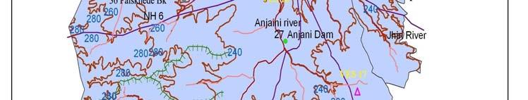


4 Figure 1 VES location map 26
5 Table 1 Stratigraphic succession of area under study area (GSI, 1976) Age Super Group Group Formation Flows Lithological characteristics Quaternary Alluvium Alluvium Upper cretaceous to Palaeocene Deccan Trap Sahyadri Ajanta formation Upper Ratnagarh formation 11 Aa flows, 5 compound Pahoehoe flows Megacryst lava flows Megacryst lava flows Dark massive, fine to medium grained, can be broken into blocks Dark massive, fine to medium grained basalts, prone to weathering effects Dark massive, fine to medium grained basalts, prone to weathering effects Alluvium Alluvial deposits occur along the lower reaches of major river valleys and watercourses. Thickness of alluvium ranges from less than a meter to several tens of meters. Alluvial plains of Girna occur in the north of the study area with a minimum elevation of 163meters above msl. Alluvium consists of unconsolidated to consolidated sand, brownish yellow silt and calcrete (locally known as kankar) along Tapi, Girna, Anjani and Jhiri River. In the study area, however, the alluvium is characterized by unconsolidated clays and silts which are of very limited thickness. These alluvial deposits are observed in many dug wells from the study area. Methodology A total 20 vertical electrical soundings have been carried out in the Anjani and Jhiri river basin at selected locations (table 2). The resistivity soundings have been carried out using the Schlumberger electrode configuration with a maximum current electrode separation (AB/2) of 100 m. Vertical Electrical Sounding (VES) data derived from field investigations were interpreted by partial curve matching technique to obtain the initial model parameters. The preliminary interpretation of the VES curves was carried out by the curve matching technique (Orellena and Moony, 1966) in which the field curves are matched with the theoretical master curve. The VES curves plotted using the IPI2WIN Geoscientific Software (Babachev, 2003). The theoretical curve that best fits the actual sounding curve specifies the thickness and resistivity of sub-surface layers of the respective VES station. 27
6 Table 2 VES locations from study area VES ID Location Longitude Latitude Elevation (masl) River Basin 1 Jurkheda E N Jhiri 2 Pimri Sim E N Anjani 3 Pimri Khurd E N Anjani 4 Chinchpura E N Jhiri 5 Dharangaon E N Anjani 6 Bambhori E N Anjani 7 Toli E N Anjani 8 Vitner E N Anjani 9 Sangvi E N Anjani 10 Babalgaon E N Anjani 11 Palsakhede Bk E N Anjani 12 Nagaon E N Anjani 13 Tarde Bk E N Anjani 14 Toli E N Anjani 15 Erandol E N Anjani 16 Anjani Dam E N Anjani 17 Galapur E N Anjani 18 Pharkande E N Anjani 19 Kasode E N Anjani 20 Musai E N Jhiri (masl indicates metres above sea-level) Results and discussion Detailed geophysical field results obtained from VES were presented in table 3. Obtained resistivity and thickness of the each layer were presented in table 4. Representative VES curve has depicted in Fig 2. Curves Types The resistivity curve types A, Q, H, K and combinations were obtained (Table 5). These curves are interpreted using the curve matching technique using two and three layer master curves (Singh and Tripathi, 2009). The different basic types of curves are: 1. Q Type ρ1> ρ2> ρ3 2. H Type ρ1> ρ2< ρ3 3. K Type ρ1< ρ2> ρ3 4. A Type ρ1< ρ2< ρ3 A combination of the basic curves can be obtained if the model is obtained for more than 3 layers. Then the combinations possible can be as: 1. HA Type ρ1> ρ2< ρ3< ρ4 2. HK Type ρ1> ρ2< ρ3> ρ4 3. AA Type ρ1< ρ2< ρ3< ρ4 4. AK Type ρ1< ρ2< ρ3> ρ4 5. KH Type ρ1< ρ2> ρ3< ρ4 6. KQ Type ρ1< ρ2> ρ3> ρ4 7. QH Type ρ1> ρ2> ρ3< ρ4 8. QQ Type ρ1> ρ2> ρ3> ρ4 28
7 In the study area 5 to 6 layer model is obtained and therefore the curve types are identified accordingly in combinations with the basic types. The first layer was top soil and weathered basalts consisting of 0.5 m - 1.7m thickness Ω.m resistivity Black cotton soil with highly weathered and fractured basalt except VES 8. The second layer consisted of 0.5 m thick black cotton soil with highly weathered and fractured basalt having Ω.m resistivity and m thickness and resistivity more than 80 Ω.m resistivity; Weakly fractured basalts and massive basalts at VES 1, 5, 6, 8, 13,15 16 and 17. The third layer was a consisted of 0.5 m thick black cotton soil with highly weathered and fractured basalt having Ω.m resistivity and m thickness and resistivity more than 80 Ω.m resistivity Weakly fractured basalts and massive basalts at VES 1, 6, 9, 14,15 17 and 18. The fourth layer was composed of 37.4 m thick 80 Ω.m resistivity of black cotton soil with highly weathered and fractured basalt and massive rock having Ω.m. The fifth layer is made up of fractured and jointed basalts and massive basalts because resistivity having up to 1581 Ω.m resistivity except VES 2, 4, 7, 11, 13, 19 and 20 which comes under either alluvial part or near the foothills. Interpretation of VES cross sections The interpreted results of VES cross sections (resistivity and thickness of layers) are correlated with geological features exposed in the vicinity of the sounding stations. Based on field observations, it is suggested to associate Ω.m zone with the weathered and fractured zone. The cross sections (Fig. 3, 4, 5 and 6) indicate that the depth of weathered and fractured zone varies from place to place. The resistivity cross sections roughly indicate that the weathered and fractured zones constituting the water-saturated zones. These low resistivity zones near Musai (VES 20), Tarde Budruk (VES 13) and Jurkheda (VES 1) roughly match with the actual field observation. It is observed that the low resistivity zones show that close to the thick cover alluvium which is observed in the actual field works. A close look at the resistivity section in the Anjani and Jhiri river basin indicates a very wide zone of weathered to fractured rocks indicated by medium resistivity zone (30-50 Ω.m) on Chinchpura (VES 4), Babalgaon (VES 10) and Kasoda (VES 19). Whereas high resistivity zones shows that close to the massive or hard rock areas which is observed in the actual field works. A close look at the resistivity section in the Anjani and Jhiri river basin indicates a very hard rock s zone indicated by high resistivity zone (>200 Ω.m) at Palskhede (VES 11), Pimri Khurd (VES 3) and Dharangaon (VES 4). 29
8 Table 3 Detailed geophysical field results obtained from VES Location AB/ Jhurkheda Rho Pimri Sim Rho Pimri Khurd Rho Chinchpura Rho Dharangaon Rho Bambhori Rho Toli Rho Vitner Rho Sangvi Rho Babalgaon Rho alsakhede Bk Rho Nagaon Rho Tarde Bk Rho Toli Rho Erandol Rho Anjani Dam Rho Galapur Rho Pharkande Rho Kasode Rho Musai Rho Maximum Minimum
9 Table 4 Table showing the ranges of the resitivity values and thickness for all the layers and curve types ES point p 1 p 2 p 3 p 4 p 5 p 6 h 1 h 2 h 3 h 4 h 5 Error % Curve type Depth of bedrock (m) (Ω.m) (Ω.m) (Ω.m) (Ω.m) (Ω.m) (Ω.m) m M m m m QHA QHA HHK KHK HKH QHK KHK HKH AKH KHK KHK KHK KHK HAK HKQ HKH KHA HAK KHK KHA 83.7 Minimum aximum Average
10 QHA 2 10 HHK 1 5 KHK 7 35 HKH 3 15 QHK 1 5 AKH 1 5 HAK 2 10 HKQ 1 5 KHA 2 10 Figure 2 Interpreted resistivity curve of VES 1


11 Figure 3 Resistivity depth section on A B Anjani and Jhiri river basin Figure 4 Resistivity depth section on C-D Anjani and Jhiri river basin


12 Figure 5 Resistivity depth section on E F Anjani and Jhiri river basin Figure 6 Resistivity depth section on E F Anjani and Jhiri river basin Conclusion The interpreted results of VES cross sections (resistivity and thickness of layers) are correlated with geological features exposed in the vicinity of sounding stations. Based on field observations, it is suggested to associate Ω.m zone with the weathered and fractured zone. The cross sections
13 look at the resistivity section in the Anjani and Jhiri river basin indicates a very wide zone of weathered to fractured rocks indicated by medium resistivity zone (30-50 Ω.m) on Chinchpura (VES 4), Babalgaon (VES 10) and Kasoda (VES 19). Whereas high resistivity zones shows that close to the massive or hard rock areas which is observed in the actual field works. A close look at the resistivity section in the Anjani and Jhiri river basin indicates a very hard rock s zone indicated by high resistivity zone (>200 Ω.m) at Palskhede (VES 11), Pimri Khurd (VES 3) and Dharangaon (VES 4). General recommendations i. Southern part of the study area is occupied by Deccan Trap Basalt, where only dug wells are most feasible structures for groundwater development. The sites for bore holes need to be selected only after proper scientific investigation. ii. The structures recommended for Basaltic areas are nala bunds, check dams and small weirs. The existing dug wells may also be used for artificial recharge of groundwater provided source water is free of silt and dissolved impurities. iii. In the Alluvial part of the study area, percolation tanks and recharge wells are suggested. iv. The study area has 02 urban towns; in these areas recommended the roof water harvesting structure for artificial recharge. v. Controlling urban expansion in the area under study, which is a recharge area of the shallow and deep aquifers, as it reduce the area of recharge and human activities will pollute the underlying aquifers in the long term. Acknowledgement Authors indebted to Department of Science and Technology, Government of India for the valuable research grant sanctioned to Dr. M. V. Baride (Research Guide) and the project Fellowship awarded to one of the Author RBG under the scheme. The co-operation of North Maharashtra University officials is also acknowledged. The author would like to thank Mrs. Baride A. M. and Dr. Shaikh Md. Babar for their suggestions, which improved the quality of this manuscript. The author also thanks to M.Sc Applied Geology students for their help during the field works. References Balakrishna, S (1980) Hydrogeophysical surveys in India. Presidential address at the Indian association of geohydrologists, NGRI, Hyderabad Babachev, A. A. (2003) IPI2 Win software, http;//geophys.geol.msu.ru Balasubramanian, A., Sharma, K.K. and Sastri, J.C.V. (1985) Geoelectrical and Hydrogeochemical Evaluation of Coastal Aquifers of Tambraparni Basin, Tamil Nadu, Geophys Res. Bulletin, 23 (4), pp Ballukraya, B.N. (1997) Groundwater over exploitation: A case study from Moje- Anepura, Kolar District, Karnataka. Jour. Geol. Soc. India, v. 50, pp Barker, R., Rao, T. V. and Thangarajan, M. (2001) Delineation of contaminant zone through electrical imaging technique, Current Sci., 81, 3, pp Buchanan, S. and Triantafilis, J (2009) Mapping water table CGWB (2009) Ground Water Information, Jalgaon district, Maharashtra 1606/DBR/ p. Golekar R B, Baride M V., Patil S N (2013) Human health risk due to trace elements contamination in
14 Griffith, D. H., and Turnbull, J. (1985) A multi-electrode array for resistivity surveying First break, 3, pp Geological Survey of India, (1976) Geology of the Jalgaon District, Maharashtra. Geol. Surv. India. 125 th Ann. Cele pp. 6 Imtiyaz, M. and Rao, D.J.M. (2008) Influence of overexploitation on groundwater ecosystem in hard rock terrain, Proceedings of International Groundwater Conference, March 19-22, Jaipur, India 88 Janardhana Raju, N., Reddy, R.V.K. and Naidu, P.T. (1996) Electrical resistivity surveys for groundwater in the upper Gunjanaru Catchment, Cuddapah District, Andhra Pradesh, Jour. Geol. Soc. Ind., v. 37, pp Karanth, K. R. (1991) Impact of human activities on hydrogeological environment. Jour. Geol. Soc. India, v. 38, pp Loke, M. H., and Barker, R. D. (1996) Rapid least squares inversion of apparent resistivity pseudo section using quasi-newton method. Geophysical Prospecting, 44, pp Majumdar, R. K. and Pal, S.K. (2005) Geoelectric and borehole lithology studies for groundwater investigations in alluvial aquifers of Munger district, Bihar. Journal Geol Society of India, 66, pp Mohamed Aslam, M.A, Kondoh, A., Mohammed Rafeeque, P. and Manoharan, A.N. (2010) Evaluating groundwater potential of a hard rock aquifer using remote sensing and geophysics. Journal of Spatial Hydrology, 10 (1) Narayanpethkar, A. B., Vasanthi, A. and Mallick, K. (2006) Electrical resistivity technique for exploration and studies on flow pattern of groundwater in multi-aquifer system in the Basaltic Terrain of Adila Basin, Maharashtra, Jour. Geol. Soc. India, v. 35(3), pp NGRI (2007) Assessment of anthropogenic groundwater contamination in Basaltic terrain, Pithampur, Industrial cluster, Indore and Dhar districts (M.P), NGRI Technical report No.NGRI Environ-601 Orellena, E. and Mooney, H. M. (1966) Master tables and curves of vertical electrical sounding over layered structures, Interciencia, Madrid, Spain, pp Pal, S.K. and Majumdar, R.K. (2001) Determination of groundwater potential zones using Isoresistivity maps in alluvial areas of Munger district, Bihar, Ind. J. of Earth Science-no-1-4,pp Pujari, P. R., and Soni, A. K. (2009) Sea water intrusion studies near Kovaya Limestone Mine, Saurashtra coast, India. Environmental Monitoring and Assessment, 154, pp Rangarajan, R. and Athavale, R. N. (2000) Annual replenishable groundwater potential of India an estimate based on injected tritium studies, J. Hydrol., 234, pp Singh, V. B. and Tripathi, J. N. (2009) An investigation of groundwater condition using geoelectrical resistivity method: A case study from some parts of Kaushambi district (U.P.), India Journal of Spatial Hydrology, v.9 (2). Urish, D. W. (1983) The practical applications of surface electrical resistivity for detection of groundwater pollution Groundwater, 21, pp Vandam, J. C., and Meulankamp, J. J. (1967) Some results of geoelectrical resistivity method in groundwater investigations in the Netherlands. Geophysical Prospecting, 15, pp Zhody, A. A. R. (1969) The use of Schlumberger and equatorial soundings on groundwater
Vertical electrical sounding (VES) for subsurface geophysical investigation in Kanigiri area, Prakasam district, Andhra Pradesh, India
 for subsurface geophysical investigation in Kanigiri area, Prakasam district, Andhra Pradesh, India") Available online at www.pelagiaresearchlibrary.com Advances in Applied Science Research, 2014, 5(5):82-86 ISSN: 0976-8610 CODEN (USA): AASRFC Vertical electrical sounding (VES) for subsurface geophysical
Available online at www.pelagiaresearchlibrary.com Advances in Applied Science Research, 2014, 5(5):82-86 ISSN: 0976-8610 CODEN (USA): AASRFC Vertical electrical sounding (VES) for subsurface geophysical
GROUNDWATER CONFIGURATION IN THE UPPER CATCHMENT OF MEGHADRIGEDDA RESERVOIR, VISAKHAPATNAM DISTRICT, ANDHRA PRADESH
 GROUNDWATER CONFIGURATION IN THE UPPER CATCHMENT OF MEGHADRIGEDDA RESERVOIR, VISAKHAPATNAM DISTRICT, ANDHRA PRADESH Prof.P.Jagadeesara Rao Department of Geo-Engineering and Centre for Remote Sensing, College
INTERNATIONAL JOURNAL OF GEOMATICS AND GEOSCIENCES Volume 3, No 1, 2012
 INTERNATIONAL JOURNAL OF GEOMATICS AND GEOSCIENCES Volume 3, No 1, 2012 Copyright by the authors - Licensee IPA- Under Creative Commons license 3.0 Research article ISSN 0976 4380 Groundwater potential
Identification of aquifer zones by VES method: A case study from Mangalore block, Tamil Nadu, S. India
 Available online at www.scholarsresearchlibrary.com Scholars Research Library Archives of Applied Science Research, 011, 3 ():414-41 (http://scholarsresearchlibrary.com/archive.html) ISSN 0975-508X CODEN
Electrical Resistivity studies for Groundwater exploration in the some parts Chopda block of Jalgaon District, Maharashtra India
 International Research Journal of Earth Sciences ISS 2321 2527 Electrical Resistivity studies for Groundwater exploration in the some parts Chopda block of Jalgaon District, Maharashtra India Abstract
RESISTIVITY IMAGING AND BOREHOLE INVESTIGATION OF THE BANTING AREA AQUIFER, SELANGOR, MALAYSIA. A.N. Ibrahim Z.Z.T. Harith M.N.M.
 JOURNAL OF ENVIRONMENTAL HYDROLOGY The Electronic Journal of the International Association for Environmental Hydrology On the World Wide Web at http://www.hydroweb.com VOLUME 11 2003 RESISTIVITY IMAGING
Study of Hydrometeorology in a Hard Rock Terrain, Kadirischist Belt Area, Anantapur District, Andhra Pradesh
 Open Journal of Geology, 2012, 2, 294-300 http://dx.doi.org/10.4236/ojg.2012.24028 Published Online October 2012 (http://www.scirp.org/journal/ojg) Study of Hydrometeorology in a Hard Rock Terrain, Kadirischist
[Penumaka, 7(1): January-March 2017] ISSN Impact Factor
![[Penumaka, 7(1): January-March 2017] ISSN Impact Factor](/thumbs/95/124653515.jpg "[Penumaka, 7(1): January-March 2017] ISSN Impact Factor") INTERNATIONAL JOURNAL OF ENGINEERING SCIENCES &MANAGEMENT HYDROGEOMORPHOLOGY OF CHEVELLA BASIN, RANGA REDDY DISTRICT, TELANGANA STATE Penumaka Ramesh* 1 & Podila Sankara Pitchaiah 2 * 1&2 Department of
INTERNATIONAL JOURNAL OF ENGINEERING SCIENCES &MANAGEMENT HYDROGEOMORPHOLOGY OF CHEVELLA BASIN, RANGA REDDY DISTRICT, TELANGANA STATE Penumaka Ramesh* 1 & Podila Sankara Pitchaiah 2 * 1&2 Department of
Groundwater Exploration In Parts Of Mangu- Halle North-Central Nigeria.
 International Journal of Scientific and Research Publications, Volume 7, Issue 10, October 2017 440 Groundwater Exploration In Parts Of Mangu- Halle North-Central Nigeria. I. Mamuda *, P.M. Akushai **
Hydrogeological Research in India
 GOLDEN JUBILEE VOLUME Hydrogeological Research in India Significant papers from the Journal and Memoirs of the Geological Society of India 1959-2008 Editor Subhajyoti Das SUB Gottingen "3 905 003 2009
Delineation of Groundwater Prospective Zones by Schlumberger electrode array in Bangriposi block of Odisha
 International Research Journal of Earth Sciences ISSN 2321 2527 Int. Res.J. Earth Sci. Delineation of Groundwater Prospective Zones by Schlumberger electrode array in Bangriposi block of Odisha Abstract
CHAPTER 9 SUMMARY AND CONCLUSIONS
 CHAPTER 9 SUMMARY AND CONCLUSIONS The following are the important conclusions and salient features of the present study. 1. The evaluation of groundwater potential is a prerequisite for any kind of planning
The Use of Vertical Electrical Sounding (VES) for Subsurface Geophysical Investigation around Bomo Area, Kaduna State, Nigeria
 for Subsurface Geophysical Investigation around Bomo Area, Kaduna State, Nigeria") IOSR Journal of Engineering (IOSRJEN) e-issn: 2250-3021, p-issn: 2278-8719 Vol. 3, Issue 1 (Jan. 2013), V4 PP 10-15 The Use of Vertical Electrical Sounding (VES) for Subsurface Geophysical Investigation
IOSR Journal of Engineering (IOSRJEN) e-issn: 2250-3021, p-issn: 2278-8719 Vol. 3, Issue 1 (Jan. 2013), V4 PP 10-15 The Use of Vertical Electrical Sounding (VES) for Subsurface Geophysical Investigation
DATA ACQUISITION METHODS FOR GROUNDWATER INVESTIGATION AND THE SITING OF WATER SUPPLY WELLS
 DATA ACQUISITION METHODS FOR GROUNDWATER INVESTIGATION AND THE SITING OF WATER SUPPLY WELLS M.B.J. Foster Tetra Tech EM Inc., San Francisco, CA, USA Keywords: Groundwater, water wells, drilled wells, geophysical
Integrated Approach to Delineate Fresh Groundwater Resources around Koganti Powers Ltd., Raichur, Karnataka, India
 5th Conference & Exposition on Petroleum Geophysics, Hyderabad-2004, India PP 937-942 around Koganti Powers Ltd., Raichur, Karnataka, India N.C. Mondal, V.S. Singh & B.A. Prakash National Geophysical Research
Prof. Stephen A. Nelson EENS 111. Groundwater
 Page 1 of 8 Prof. Stephen A. Nelson EENS 111 Tulane University Physical Geology This page last updated on 20-Oct-2003 is water that exists in the pore spaces and fractures in rock and sediment beneath
Delineation of aquifers in basaltic hard rock terrain using vertical electrical soundings data
 Delineation of aquifers in basaltic hard rock terrain using vertical electrical soundings data SNRai, S Thiagarajan, Y Ratna Kumari, V Anand Rao and A Manglik CSIR National Geophysical Research Institute,
DETECTION OF GROUNDWATER POLLUTION USING RESISTIVITY IMAGING AT SERI PETALING LANDFILL, MALAYSIA
 JOURNAL OF ENVIRONMENTAL HYDROLOGY The Electronic Journal of the International Association for Environmental Hydrology On the World Wide Web at http://www.hydroweb.com VOLUME 8 2000 DETECTION OF GROUNDWATER
THINK GLOBAL & ACT LOCAL
 GROUNDWATER RECHARGE IN THE BASALTIC TERRAIN FOR RAINWATER HARVESTING : EVERYWHERE BUT NOT ANYWHERE THINK GLOBAL & ACT LOCAL magazine for youth INKING INNOVATIONS Abstract For The last Decade or so one
Land subsidence due to groundwater withdrawal in Hanoi, Vietnam
 Land Subsidence (Proceedings of the Fifth International Symposium on Land Subsidence, The Hague, October 1995). 1AHS Publ. no. 234, 1995. 55 Land subsidence due to groundwater withdrawal in Hanoi, Vietnam
Study on Bromide in Groundwater in Parts of Nalgonda District, Andhra Pradesh
 e-journal Earth Science India, Vol. 3 (I), January, 2010, pp.73-80 http://www.earthscienceindia.info/; ISSN: 0974 8350 Study on Bromide in Groundwater in Parts of Nalgonda District, Andhra Pradesh K. Brindha
11/22/2010. Groundwater in Unconsolidated Deposits. Alluvial (fluvial) deposits. - consist of gravel, sand, silt and clay
 deposits. - consist of gravel, sand, silt and clay") Groundwater in Unconsolidated Deposits Alluvial (fluvial) deposits - consist of gravel, sand, silt and clay - laid down by physical processes in rivers and flood plains - major sources for water supplies
Groundwater in Unconsolidated Deposits Alluvial (fluvial) deposits - consist of gravel, sand, silt and clay - laid down by physical processes in rivers and flood plains - major sources for water supplies
Groundwater Sustainability at Wadi Al Bih Dam, Ras El Khaimah, United Arab Emirates (UAE) using Geophysical methods
 using Geophysical methods") Groundwater Sustainability at Wadi Al Bih Dam, Ras El Khaimah, United Arab Emirates (UAE) using Geophysical methods Ahmed Murad, Amir Gabr, Saber Mahmoud, Hasan Arman & Abdulla Al Dhuhoori Geology Department
Groundwater Sustainability at Wadi Al Bih Dam, Ras El Khaimah, United Arab Emirates (UAE) using Geophysical methods Ahmed Murad, Amir Gabr, Saber Mahmoud, Hasan Arman & Abdulla Al Dhuhoori Geology Department
A Preliminary Geophysical Reconnaissance Mapping of Emirau Ground Water Resource, Emirau Island, New Ireland Province, PNG
 A Preliminary Geophysical Reconnaissance Mapping of Emirau Ground Water Resource, Emirau Island, New Ireland Province, PNG Geological Survey Division of Mineral Resources Authority (MRA) Papua New Guinea
AQUIFER CHARACTERIZATION AND GROUNDWATER POTENTIAL ASSESSMENT OF THE SEDIMENTARY BASIN OF ONDO STATE. Faleye, E. T. and Olorunfemi, M. O.
 Ife Journal of Science vol. 17, no. 2 (2015) AQUIFER CHARACTERIZATION AND GROUNDWATER POTENTIAL ASSESSMENT OF THE SEDIMENTARY BASIN OF ONDO STATE 429 1 2 Faleye, E. T. and Olorunfemi, M. O. 1 Dept. of
Assessment of Ground Water in a Part of Coastal West Bengal using Geo-Electrical Method
 Vol. 13, No. 2, pp. 203-210 (2013) Journal of Agricultural Physics ISSN 0973-032X http://www.agrophysics.in Research Article Assessment of Ground Water in a Part of Coastal West Bengal using Geo-Electrical
Groundwater Assessment in Apapa Coast-Line Area of Lagos Using Electrical Resistivity Method
 Journal of Emerging Trends in Engineering and Applied Sciences (JETEAS) 2 (4): 673-679 Scholarlink Research Institute Journals, 2011 (ISSN: 2141-7016) jeteas.scholarlinkresearch.org Groundwater Assessment
STUDY AREA AND METHODOLOGY
 . CHAPTER 2 STUDY AREA AND METHODOLOGY 26 CHAPTER 2 STUDY AREA AND METHODOLOGY Kundalika is a major river in konkan region of Maharashtra. River originates in Western Ghats at an altitude of 820 m ASL
APPLICATION OF ELECTRICAL RESISTIVITY TOMOGRAPHY FOR SAND UNDERWATER EXTRACTION
 International Scientific Conference GEOBALCANICA 2018 APPLICATION OF ELECTRICAL RESISTIVITY TOMOGRAPHY FOR SAND UNDERWATER EXTRACTION Maya Grigorova Ivaylo Koprev University of Mining and Geology St. Ivan
2D Resistivity Imaging Investigation of Solid Waste Landfill Sites in Ikhueniro Municipality, Ikpoba Okha Local Government Area,Edo State, Nigeria.
 2D Resistivity Imaging Investigation of Solid Waste Landfill Sites in Ikhueniro Municipality, Ikpoba Okha Local Government Area,Edo State, Nigeria. Iyoha. A, Akhirevbulu O.E, Amadasun C.V.O and Evboumwan
Hydrologic Modelling of the Upper Malaprabha Catchment using ArcView SWAT
 Hydrologic Modelling of the Upper Malaprabha Catchment using ArcView SWAT Technical briefs are short summaries of the models used in the project aimed at nontechnical readers. The aim of the PES India
GEOELECTRICAL INVESTIGATIONS OF MARINE INTRUSIONS ON THE ROMANIAN BLACK SEA SHORE
 GEOELECTRICAL INVESTIGATIONS OF MARINE INTRUSIONS ON THE ROMANIAN BLACK SEA SHORE P. GEORGESCU, D. IOANE, B.M. NICULESCU, F. CHITEA University of Bucharest, Department of Geophysics, 6 Traian Vuia Street,
Electrical Resistivity Survey for Delineating Seawater Intrusion in a Coastal Aquifer
 Electrical Resistivity Survey for Delineating Seawater Intrusion in a Coastal Aquifer Sung-Ho Song*, Gyu-Sang Lee*, Jin-Sung Kim*, Baekuk Seong*, Young-gyu Kim*, Myung-Ha Woo* and Namsik Park** Abstract
Analysis of Rainfall and Other Weather Parameters under Climatic Variability of Parbhani ( )
") International Journal of Current Microbiology and Applied Sciences ISSN: 2319-7706 Volume 7 Number 06 (2018) Journal homepage: http://www.ijcmas.com Original Research Article https://doi.org/10.20546/ijcmas.2018.706.295
International Journal of Current Microbiology and Applied Sciences ISSN: 2319-7706 Volume 7 Number 06 (2018) Journal homepage: http://www.ijcmas.com Original Research Article https://doi.org/10.20546/ijcmas.2018.706.295
GROUNDWATER QUALITY WITH SPECIAL REFERENCE TO FLUOROSIS OF KONGHARA DHARANA REGION, DISTRICT YAVATMAL MAHARASHTRA, INDIA.
 International Journal of Science, Environment and Technology, Vol. 1, No 5, 2012, 425-429 GROUNDWATER QUALITY WITH SPECIAL REFERENCE TO FLUOROSIS OF KONGHARA DHARANA REGION, DISTRICT YAVATMAL MAHARASHTRA,
International Journal of Modern Trends in Engineering and Research e-issn No.: , Date: April, 2016
 International Journal of Modern Trends in Engineering and Research www.ijmter.com e-issn No.:2349-9745, Date: 28-30 April, 2016 Landslide Hazard Management Maps for Settlements in Yelwandi River Basin,
The Preliminary Study of Meteorite Impact Crater at Bukit Bunuh, Lenggong
 2012 International Conference on Geological and Environmental Sciences IPCBEE vol.3 6(2012) (2012)IACSIT Press, Singapoore The Preliminary Study of Meteorite Impact Crater at Bukit Bunuh, Lenggong A. H.
Morenikeji P. Anjorin, B.Tech. 1 and Martins O. Olorunfemi, Ph.D. 2*
 A Short Note on Comparative Study of Schlumberger and Half Schlumberger Arrays in Vertical Electrical Sounding in a Basement Complex Terrain of Southwest Nigeria. Morenikeji P. Anjorin, B.Tech. 1 and Martins
SUITABILITY OF ELECTRICAL RESISTIVITY SURVEY FOR SELECTING ANICUT SITE IN ORDER TO AUGMENT GROUND WATER A CASE STUDY
 Annals of Arid Zone 30 (3) : 187-195, 1991 SUTABLTY OF ELECTRCAL RESSTVTY SURVEY FOR SELECTNG ANCUT STE N ORDER TO AUGMENT GROUND WATER A CASE STUDY J.P. SHUKLA* and S.M. PANDEY Ground Water Department,
S.I. Fadele, M.Sc. 1 ; P.O. Sule, Ph.D. 1 ; and B.B.M. Dewu, Ph.D * ABSTRACT
 The Use of Vertical Electrical Sounding (VES) for Groundwater Exploration around Nigerian College of Aviation Technology (NCAT), Zaria, Kaduna State, Nigeria. S.I. Fadele, M.Sc. 1 ; P.O. Sule, Ph.D. 1
GEOELECTRICAL INVESTIGATION OF GROUNDWATER CONDITION IN OLEH, NIGERIA
 www.arpapress.com/volumes/vol15issue1/ijrras_15_1_14.pdf GEOELECTRICAL INVESTIGATION OF GROUNDWATER CONDITION IN OLEH, NIGERIA O. Anomohanran Physics Department, Delta State University, Abraka, Delta State,
Subsurface investigations in lower Palar river basin using vertical electrical resistivity surveys
 Subsurface investigations in lower Palar river basin using vertical electrical resistivity surveys K.Parmasivam, G.Vijayakumar and K.K. Sharma Department of Applied Geology, University of Madras, Guindy
Application of Remote Sensing and Geo-Electrical Method for Groundwater Exploration in Khor Al Alabyad, North Kordofan State, Sudan
 American Journal of Earth Sciences 2015; 2(6): 242-246 Published online January 10, 2016 (http://www.openscienceonline.com/journal/ajes) ISSN: 2381-4624 (Print); ISSN: 2381-4632 (Online) Application of
Probability models for weekly rainfall at Thrissur
 Journal of Tropical Agriculture 53 (1) : 56-6, 015 56 Probability models for weekly rainfall at Thrissur C. Laly John * and B. Ajithkumar *Department of Agricultural Statistics, College of Horticulture,
Elijah Adebowale Ayolabi, Ph.D. 1, Adetayo Femi Folorunso, M.Sc. 2*, Ayodele Franklin Eleyinmi, B.Sc. 1, and Esther O. Anuyah, B.Sc.
 Applications of 1D and 2D Electrical Resistivity Methods to Map Aquifers in a Complex Geologic Terrain of Foursquare Camp, Ajebo, Southwestern Nigeria. Elijah Adebowale Ayolabi, Ph.D. 1, Adetayo Femi Folorunso,
Geophysical Investigation of Egbeta, Edo State, Nigeria, Using Electrical Resistivity Survey to Assess the Ground water Potential
 368 Geophysical Investigation of Egbeta, Edo State, Nigeria, Using Electrical Resistivity Survey to Assess the Ground water Potential 1 Aigbogun, Christopher O., 1 Adegbite, Joseph, T., 2 Olorunsola,Kuforijimi,
DELINEATION OF FRESH-BRACKISH WATER AND BRACKISH-SALINE WATER INTERFACES USING VES SOUNDINGS IN SHANI, BORNO STATE, NIGERIA
 JOURNAL OF ENVIRONMENTAL HYDROLOGY The Electronic Journal of the International Association for Environmental Hydrology On the World Wide Web at http://www.hydroweb.com VOLUME 19 2011 DELINEATION OF FRESH-BRACKISH
CHARACTERIZATION OF SOIL PROFILE OF DHAKA CITY USING ELECTRICAL RESISTIVITY TOMOGRAPHY (ERT)
") CHARACTERIZATION OF SOIL PROFILE OF DHAKA CITY USING ELECTRICAL RESISTIVITY TOMOGRAPHY (ERT) Mehedi Ahmed ANSARY 1, B.S. Pushpendue BISWAS 2 and Abul KHAIR 3 1 Professor, Department of Civil Engineering
CHARACTERIZATION OF SOIL PROFILE OF DHAKA CITY USING ELECTRICAL RESISTIVITY TOMOGRAPHY (ERT) Mehedi Ahmed ANSARY 1, B.S. Pushpendue BISWAS 2 and Abul KHAIR 3 1 Professor, Department of Civil Engineering
Azimuthal Resistivity to Characterize Fractures in a Glacial Till. Mark Boris, University of Saskatchewan Jim Merriam, University of Saskatchewan
 Azimuthal Resistivity to Characterize Fractures in a Glacial Till Mark Boris, University of Saskatchewan Jim Merriam, University of Saskatchewan Abstract Azimuthal resistivity was used to characterize
Temporal geoelectric behaviour of dyke aquifers in northern Deccan Volcanic Province, India
 Temporal geoelectric behaviour of dyke aquifers in northern Deccan Volcanic Province, India Gautam Gupta 1,, Vinit C Erram 1 and Suyash Kumar 2 1 Indian Institute of Geomagnetism, Kalamboli Highway, Navi
Hydro-Geophysical Investigation of the Federal Housing Estate Akure, Southwestern Nigeria
 Journal of Emerging Trends in Engineering and Applied Sciences (JETEAS) 4(6): 793-799 Scholarlink Research Institute Journals, 2013 (ISSN: 2141-7016) jeteas.scholarlinkresearch.org Journal of Emerging
Delineation of Groundwater Potential Zone on Brantas Groundwater Basin
 Delineation of Groundwater Potential Zone on Brantas Groundwater Basin Andi Rachman Putra 1, Ali Masduqi 2 1,2 Departement of Environmental Engineering, Sepuluh Nopember Institute of Technology, Indonesia
Groundwater Exploration in Hard Rock Areas of Vizianagaram District, Andhra Pradesh, India
 J. Ind. Geophys. Union ( April 2007 ) Vol.11, No.2, pp.79-90 Groundwater Exploration in Hard Rock Areas of Vizianagaram District, Andhra Pradesh, India S.N.Das, N.C.Mondal 1 and V.S.Singh 1 Action For
Impact of the Danube River on the groundwater dynamics in the Kozloduy Lowland
 GEOLOGICA BALCANICA, 46 (2), Sofia, Nov. 2017, pp. 33 39. Impact of the Danube River on the groundwater dynamics in the Kozloduy Lowland Peter Gerginov Geological Institute, Bulgarian Academy of Sciences,
Ground Magnetic and Electrical Resistivity Mapping for Basement Structurs over Charnokitic Terrain in Ado-Ekiti Area, Southwestern Nigeria
 International Journal of Science and Technology Volume 3 No. 10, October, 2014 Ground Magnetic and Electrical Resistivity Mapping for Basement Structurs over Charnokitic Terrain in Ado-Ekiti Area, Southwestern
3D Electrical Resistivity Tomography (ERT) Survey of a Typical Basement Complex Terrain
 Survey of a Typical Basement Complex Terrain") Journal of Emerging Trends in Engineering and Applied Sciences (JETEAS) 2 (4): 680-686 Scholarlink Research Institute Journals, 2011 (ISSN: 2141-7016) jeteas.scholarlinkresearch.org Journal of Emerging
Journal of Emerging Trends in Engineering and Applied Sciences (JETEAS) 2 (4): 680-686 Scholarlink Research Institute Journals, 2011 (ISSN: 2141-7016) jeteas.scholarlinkresearch.org Journal of Emerging
2-D RESISTIVITY IMAGING SURVEY FOR WATER-SUPPLY TUBE WELLS IN A BASEMENT COMPLEX: A CASE STUDY OF OOU CAMPUS, AGO-IWOYE SW NIGERIA
 2-D RESISTIVITY IMAGING SURVEY FOR WATER-SUPPLY TUBE WELLS IN A BASEMENT COMPLEX: A CASE STUDY OF OOU CAMPUS, AGO-IWOYE SW NIGERIA 1 AYOLABI, Elijah Adebowale. 2 FOLORUNSO, Adetayo Femi. and 3 ARIYO, Stephen
INTERNATIONAL AND NATIONAL JOURNAL PAPERS
 INTERNATIONAL AND NATIONAL JOURNAL PAPERS 1. Groundwater geochemistry and identification of hydrogeochemical processes in a hard rock region, Southern India by T.Subramani, L.Elango and N.Rajmohan; International
KANSAS GEOLOGICAL SURVEY Open File Report LAND SUBSIDENCE KIOWA COUNTY, KANSAS. May 2, 2007
 KANSAS GEOLOGICAL SURVEY Open File Report 2007-22 LAND SUBSIDENCE KIOWA COUNTY, KANSAS Prepared by Michael T. Dealy L.G., Manager, Wichita Operations SITE LOCATION The site was approximately four miles
Groundwater Level Monitoring of the Quaternary Aquifer at Al Ain City, United Arab Emirates (UAE) using Geophysical Methods
 using Geophysical Methods") Groundwater Level Monitoring of the Quaternary Aquifer at Al Ain City, United Arab Emirates (UAE) using Geophysical Methods Ahmed Murad & Amir Gabr Geology Department UAE University Outlines Introduction
Groundwater Level Monitoring of the Quaternary Aquifer at Al Ain City, United Arab Emirates (UAE) using Geophysical Methods Ahmed Murad & Amir Gabr Geology Department UAE University Outlines Introduction
Geophysical Investigation of Foundation Condition of A Site in Ikere- Ekiti, Ekiti State, South-Western Nigeria
 Australian Journal of Basic and Applied Sciences, 5(9): 1852-1857, 2011 ISSN 1991-8178 Geophysical Investigation of Foundation Condition of A Site in Ikere- Ekiti, Ekiti State, South-Western Nigeria 1
ELECTRICAL RESISTIVITY DATA INTERPRETATION FOR GROUNDWATER DETECTION IN TITTAGUDI TALUK OF CUDDALORE DISTRICT, TAMIL NADU, INDIA
 ELECTRICAL RESISTIVITY DATA INTERPRETATION FOR GROUNDWATER DETECTION IN TITTAGUDI TALUK OF CUDDALORE DISTRICT, TAMIL NADU, INDIA Uwamungu Placide 1, G.R. Senthil Kumar 2 1 M.Phil Research Scholar, Department
Delineation of Zones at Risk from Groundwater Inflows at an Underground Platinum Mine in South Africa
 Delineation of Zones at Risk from Groundwater Inflows at an Underground Platinum Mine in South Africa Mr Andreas Stoll andreas.stoll@erm.com Environmental Resources Management Swiss GmbH (ERM), Switzerland
GROUNDWATER OCCURRENCE IN KENYA
 GROUNDWATER OCCURRENCE IN KENYA Steven Okoth Owuor Ministry of Water and Sanitation Sunday, January 20, 2019 1 Geography INTRODUCTION The Republic of Kenya is located in East Africa The total area of the
HYDROGEOLOGICAL PROPERTIES OF THE UG2 PYROXENITE AQUIFERS OF THE BUSHVELD COMPLEX
 R. Gebrekristos, P.Cheshire HYDROGEOLOGICAL PROPERTIES OF THE UG2 PYROXENITE AQUIFERS OF THE BUSHVELD COMPLEX R. Gebrekristos Digby Wells Environmental P. Cheshire Groundwater Monitoring Services Abstract
G. Barrocu G. Ranieri Faculty of Engineering, University of Cagliari, Italy. In the region of Muravera, south-east coast of Sardinia, the trend of
 HYDROGEOLOGICAL AND GEOPHYSICAL INVESTIGATIONS FOR EVALUATING SALT INTRUSION PHENOMENA IN SARDINIA G. Barbieri G. Barrocu G. Ranieri Faculty of Engineering, University of Cagliari, Italy Abstract In the
Soils, Hydrogeology, and Aquifer Properties. Philip B. Bedient 2006 Rice University
 Soils, Hydrogeology, and Aquifer Properties Philip B. Bedient 2006 Rice University Charbeneau, 2000. Basin Hydrologic Cycle Global Water Supply Distribution 3% of earth s water is fresh - 97% oceans 1%
Analysis of electrical resistivity data for the determination of aquifer depth at Sapele RD in Benin city
 Available online at www.pelagiaresearchlibrary.com Advances in Applied Science Research, 203, 4(6):268-276 ISSN: 0976-860 CODEN (USA): AASRFC Analysis of electrical resistivity data for the determination
Vertical Electrical Sounding Survey for Groundwater Exploration in Parts of Anyigba and its Environs, in the Anambra Basin of Nigeria
 British Journal of Applied Science & Technology 4(): 978-988, 204 SCIENCEDOMAIN international www.sciencedomain.org Vertical Electrical Sounding Survey for Groundwater Exploration in Parts of and its Environs,
Figure 2.1: Constituent Area
 2 The Region 2.1 CONSTITUENT AREA The National Capital Region includes NCT-Delhi, nine districts of Haryana, six districts of Uttar Pradesh and one district of Rajasthan. Total area of the region is 34,144
Rainfall variation and frequency analysis study of Salem district Tamil Nadu
 Indian Journal of Geo Marine Sciences Vol. 46 (1), January 217, pp. 213-218 Rainfall variation and frequency analysis study of Salem district Tamil Nadu Arulmozhi.S 1* & Dr. Prince Arulraj.G 2 1 Department
 12 10 8 6 4 2 0 40-50 50-60 60-70 70-80 80-90 90-100 Fresh Water What we will cover The Hydrologic Cycle River systems Floods Groundwater Caves and Karst Topography Hot springs Distribution of water in
Ground Water Potential Mapping in Chinnar Watershed (Koneri Sub Watershed) Using Remote Sensing & GIS
 Using Remote Sensing & GIS") Ground Water Potential Mapping in Chinnar Watershed (Koneri Sub Watershed) Using Remote Sensing & GIS T.Velmurugan 1 Dr.D.Srinivasan 2 1 Assistant professor/civil, Roever Engineering College, Perambalur.
Ground Water Potential Mapping in Chinnar Watershed (Koneri Sub Watershed) Using Remote Sensing & GIS T.Velmurugan 1 Dr.D.Srinivasan 2 1 Assistant professor/civil, Roever Engineering College, Perambalur.
Morphometric Analysis Of Bhogavati River Basin, Kolhapur District, Maharashtra, India.
 IOSR Journal of Mechanical and Civil Engineering (IOSR-JMCE) ISSN: 2278-1684, PP: 01-08 www.iosrjournals.org Morphometric Analysis Of Bhogavati River Basin, Kolhapur District, Maharashtra, India. P. A.
Flood hazard mapping in Urban Council limit, Vavuniya District, Sri Lanka- A GIS approach
 International Research Journal of Environment Sciences E-ISSN 2319 1414 Flood hazard mapping in Urban Council limit, Vavuniya District, Sri Lanka- A GIS approach Abstract M.S.R. Akther* and G. Tharani
Geophysical Investigation: A Case Study of Basement Complex, Nigeria
 Geophysical Investigation: A Case Study of Basement Complex, Nigeria Adiela U.P 1, Ayodele Moses Oyewole 2 and Omoirabor Omoleomo 3 1 Department of Petroleum Engineering, Nigerian Agip Oil Company, Port
Case Study: University of Connecticut (UConn) Landfill
 Landfill") Case Study: University of Connecticut (UConn) Landfill Problem Statement:» Locate disposal trenches» Identify geologic features and distinguish them from leachate and locate preferential pathways in fractured
Case Study: University of Connecticut (UConn) Landfill Problem Statement:» Locate disposal trenches» Identify geologic features and distinguish them from leachate and locate preferential pathways in fractured
Scholars Research Library
 Available online at www.scholarsresearchlibrary.com Scholars Research Library Archives of Applied Science Research, 010, (): 4-34 (http://scholarsresearchlibrary.com/archive.html) ISSN 0975-508X CODEN
Integration of Seismic Refraction and 2D Electrical Resistivity in Locating Geological Contact
 Open Journal of Geology, 2013, 3, 7-12 doi:10.4236/ojg.2013.32b002 Published Online April 2013 (http://www.scirp.org/journal/ojg) Integration of Seismic Refraction and 2D Electrical Resistivity in Locating
Research Article Delineation of Fractured Aquifer Using Numerical Analysis (Factor) of Resistivity Data in a Granite Terrain
 of Resistivity Data in a Granite Terrain") International Geophysics, Article ID 585204, 8 pages http://dx.doi.org/10.1155/2014/585204 Research Article Delineation of Fractured Aquifer Using Numerical Analysis (Factor) of Resistivity Data in a Granite
International Geophysics, Article ID 585204, 8 pages http://dx.doi.org/10.1155/2014/585204 Research Article Delineation of Fractured Aquifer Using Numerical Analysis (Factor) of Resistivity Data in a Granite
Rainfall is the major source of water for
 RESEARCH PAPER: Assessment of occurrence and frequency of drought using rainfall data in Coimbatore, India M. MANIKANDAN AND D.TAMILMANI Asian Journal of Environmental Science December, 2011 Vol. 6 Issue
SITE SELECTION CRITERIA FOR A SOLAR PV PLANT. Under The Guidence of SOHEL PATEL
 SITE SELECTION CRITERIA FOR A SOLAR PV PLANT Under The Guidence of SOHEL PATEL CONTENTS Introduction Selection of land 1.area longitude & latitude 2.quality of soil 3.soil test report 4.Terrain & contours
Evaluation of Subsurface Formation of Pabna District, Bangladesh
 IOSR Journal of Applied Geology and Geophysics (IOSR-JAGG) e-issn: 2321 0990, p-issn: 2321 0982.Volume 1, Issue 4 (Sep. Oct. 2013), PP 30-36 Evaluation of Subsurface Formation of Pabna District, Bangladesh
1.0 Introduction 1.1 Geographic Location 1.2 Topography 1.3 Climate and Rainfall 1.4 Geology and Hydrogeology 1.5 Water Availability 1.
 1.0 1.1 Geographic Location 1.2 Topography 1.3 Climate and Rainfall 1.4 Geology and Hydrogeology 1.5 Water Availability 1.6 Demography 1.0 1.1 Geographic Location St. Lucia forms part of an archipelago
Causes of Borehole Failure in Complex Basement Terrains: ABUAD Case Study, Southwestern Nigeria. w w w. a j e r. o r g Page 192
 American Journal of Engineering Research (AJER) e-issn: 2320-0847 p-issn : 2320-0936 Volume-4, Issue-10, pp-192-201 www.ajer.org Research Paper Open Access Causes of Borehole Failure in Complex Basement
MICRO LEVEL GEO-RESISTIVITY SURVEY THROUGH V.E.S. TEST FOR GROUNDWATER FEASIBILITY STUDY AND SELECTION OF BORE WELL SITES IN PIPILI BLOCK OF PURI
 Review of Environment and Earth Sciences 2014 Vol.1, No.2, pp. 37-45 ISSN(e): 2313-8440 ISSN(p): 2409-2150 DOI: 10.18488/journal.80/2014.1.2/80.2.37.45 MICRO LEVEL GEO-RESISTIVITY SURVEY THROUGH V.E.S.
A Case Study of High-Resolution Gravity and Wenner-Schlumberger Resistivity for Geotechnical Engineering: An Example from North Jordan
 Research Journal of Applied Sciences, Engineering and Technology 5(4): 1377-1382-, 2013 ISSN: 2040-7459; e-issn: 2040-7467 Maxwell Scientific Organization, 2013 Submitted: July 09, 2012 Accepted: August
Chapter 13. Groundwater
 Chapter 13 Groundwater Introduction Groundwater is all subsurface water that completely fills the pores and other open spaces in rocks, sediments, and soil. Groundwater is responsible for forming beautiful
variation analysis of Vattamalaikarai sub basin, Tamil Nadu, India.
 A Study on the Rainfall Changes of Orathanadu Taluk Thanjavur District Tamil Nadu Using GIS P. Sujatha 1, Dr. R Baskaran 2 1 Research Scholar, Department of Industries and Earth Sciences, Tamil University,
GROUNDWATER EXPLORATION
 CHAPTER 6 GROUNDWATER EXPLORATION 6.1 INTRODUCTION Water is one of the m water is one of the prerequisites for development and industrial growth. In areas where surface water is not available, groundwater
Hydro-Geophysical Study of River Niger Floodplain at Jebba-North, Nigeria
 Journal of Emerging Trends in Engineering and Applied Sciences (JETEAS) 3 (1): 152-158 Scholarlink Research Institute Journals, 212 (ISSN: 2141-716) jeteas.scholarlinkresearch.org Journal of Emerging Trends
PALLAVI CHATTOPADHYAY
 Dr. (Mrs.) PALLAVI CHATTOPADHYAY Assistant Professor Department of Earth Sciences Indian Institute of Technology Roorkee-247667, Uttarakhand, India E-mail: cpallavi.fes@iitr.ac.in/vns_pal@yahoo.co.in Contact
Influence of Paleochannels on Seepage
 Study 4 Influence of Paleochannels on Seepage Public Draft 2014 Monitoring and Analysis Plan September 2013 August 2012 Influence of Paleochannels on Seepage 1. Statement of Need Historical maps, aerial
VILLAGE INFORMATION SYSTEM (V.I.S) FOR WATERSHED MANAGEMENT IN THE NORTH AHMADNAGAR DISTRICT, MAHARASHTRA
 FOR WATERSHED MANAGEMENT IN THE NORTH AHMADNAGAR DISTRICT, MAHARASHTRA") VILLAGE INFORMATION SYSTEM (V.I.S) FOR WATERSHED MANAGEMENT IN THE NORTH AHMADNAGAR DISTRICT, MAHARASHTRA Abstract: The drought prone zone in the Western Maharashtra is not in position to achieve the agricultural
VILLAGE INFORMATION SYSTEM (V.I.S) FOR WATERSHED MANAGEMENT IN THE NORTH AHMADNAGAR DISTRICT, MAHARASHTRA Abstract: The drought prone zone in the Western Maharashtra is not in position to achieve the agricultural
Characterization of the geology and subsurface crystalline limestone mining using 2D ERI at Puthur Mines, Tirunelveli, Tamilnadu
 Available online at www.scholarsresearchlibrary.com Archives of Applied Science Research, 2012, 4 (3):1261-1265 (http://scholarsresearchlibrary.com/archive.html) ISSN 0975-508X CODEN (USA) AASRC9 Characterization
Underground water exploration of Oleh, Nigeria using the electrical resistivity method
 Scientific Research and Essays Vol. 6(20), pp. 4295-4300, 19 September, 2011 Available online at http://www.academicjournals.org/sre ISSN 1992-2248 2011 Academic Journals Full Length Research Paper Underground
Chapter- Three GEOMORPHOLOGY AND RAINFALL PATTERN
 Chapter- Three GEOMORPHOLOGY AND RAINFALL PATTERN 3.1 INTRODUCTION Geomorphology and its slope as a basic and applied science in general and as tool for searching groundwater resources in efficient geomorphological
' International Institute for Land Reclamation and Improvement. 2 Groundwater Investigations. N.A. de Ridder'? 2.1 Introduction. 2.
 2 Groundwater Investigations N.A. de Ridder'? 2.1 Introduction Successful drainage depends largely on a proper diagnosis of the causes of the excess water. For this diagnosis, one must consider: climate,
Nishad Patki 1, V.R.Ghodke2, and N. J. Sathe 1
 Proceeding of nternational Conference SWM-2 elineation Of echarging Zones For Groundwater n Bhima iver Basin, Pandharpur, Maharashtra ishad Patki, V..Ghodke2, and. J. Sathe epartment of Civil Engg., Sinhgad
Rainfall Trend in Semi Arid Region Yerala River Basin of Western Maharashtra, India
 Rainfall Trend in Semi Arid Region Yerala River Basin of Western Maharashtra, India Abhijit M. Zende 1, Dr. R. Nagarajan 2, Kamalkishor R. Atal 3 1&2 Centre of Studies in Resource Engineering, Indian Institute