OCCURRENCE OF OIL IN METAMORPHIC ROCKS OF SAN- GABRIEL MOUNTAINS, LOS ANGELES COUNTY, CALIFORNIA 1
|
|
|
- Osborne Reynolds
- 5 years ago
- Views:
Transcription
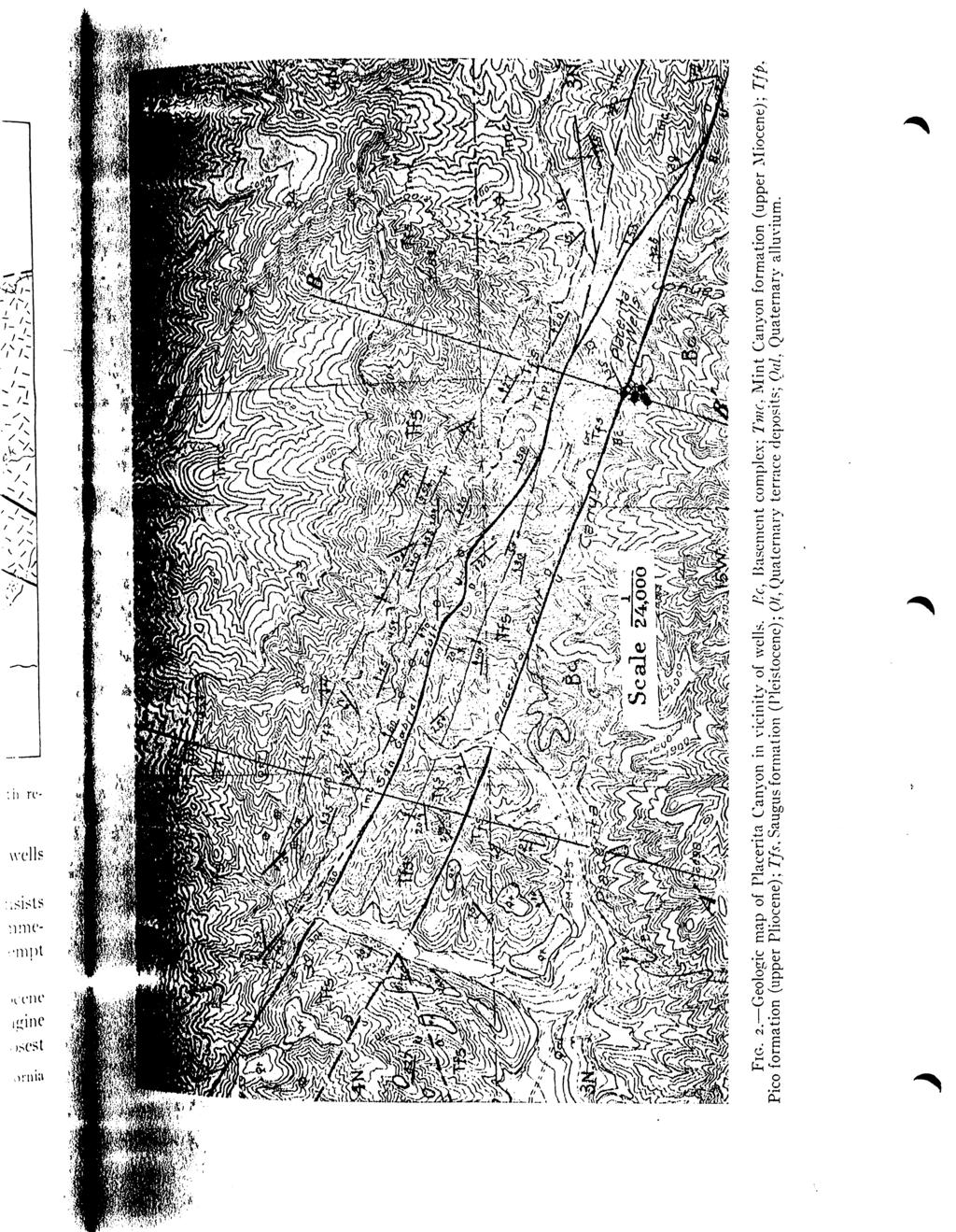
1 BULUET1N OF THE AMERICAN ASSOCIATION OF PETROLEUM GEOLOGISTS VOL. 16. NO. 8 (AUGUST. 1932), PP , 3 FIGS. OCCURRENCE OF OIL IN METAMORPHIC ROCKS OF SAN- GABRIEL MOUNTAINS, LOS ANGELES COUNTY, CALIFORNIA 1 ARTHUR B. BROWN and W. S. W. KEW^ Los Angeles, California ABSTRACT An occurrence of nearly water-white light-gravity oil obtained from wells drilled into metamorphic rocks on the north side of the San Gabriel Mountains, Los Angeles County, California, has been of interest to geologists for many years. The metamorphic rocks are in fault contact with sedimentary rocks, those at the surface being of late Pliocene and Pleistocene age. From a detailed study of the geology of this region the conclusion is reached that the oil has migrated in Eocene strata underlying the Pliocene and migrated along faults to its present position in the crystalline rocks. Filtration taking place during this migration is thought to have been competent to pro duce this light oil having a high percentage of aromatic hydrocarbons. Six wells drilled between 1899 and 1901 in Placerita Canyon, near Newhall, Los Angeles County, California (SE. corner of NE. yi of Sec. 4, T. 3 N., R. 15 W., S. B. B. and M.) are of particular interest to those studying the occurrence of oil, due to the fact that they are located, for the most part, in the metamorphic rocks of the San Gabriel Mountains. They formerly produced small quantities of light-gravity, almost waterwhite oil from this formation. Neither of the two wells now capable of yielding oil is commercially productive. One is shut in and the other is open and flowing a small amount of gas with about a gallon per day of fluid of which not more than about 15 per cent is oil. In addition, several unsuccessful tests have been drilled in this vicinity at various times.' All the wells were drilled with cable tools, and logs which might have any geologic value are not available. The most northerly of this group of six wells was drilled practically on the fault contact between the metamorphic rocks of the San Gabriel Mountains on the south, and 'Published by permission of G. C. Gester, chief geologist, Standard Oil Company of California. Manuscript received, June 23, Standard Oil Company of California. 3 G. H. Eldridge and Ralph Arnold, "The Santa Clara Valley, Puente Hills, and Los Angeles Basin Oil Districts, Southern California," U. S. Geol. Survey Bull. 30Q (1907), p W. S. W. Kew, "Geology and Oil Resources of a Part of Los Angeles and Ventura Counties, California," U. S. Geol. Survey Bull. 753 (1924), pp
2 77«ARTHUR B. BROWS AND \Y. S. II. KE\Y FIG. I. Generalized map showing location of Placerita Canyon wells with respect to Basement complex and sedimentary rocks. the Saugus formation (Pleistocene) on the north. The other five wells were located within the area of metamorphic rocks. The "Basement complex" of the San Gabriel Mountains consists of schists, gneisses, and various types of igneous rocks. In the immediate vicinity of the Placerita wells schists predominate, but no attempt has been made to classify the various rock types. The oldest post-crystalline rocks known in the district are Eocene shales, sandstones, and conglomerates correlated with the Domengine formation, which crop out near by in Elsmere Canyon.' The closest l W. S. W. Kew. Paper read before Geology and Paleontology (.Hub. California Institute of Technology, March 31, 1931.
3
4 780 ARTHUR B. BROWN AND W. S. W. KEW known occurrence to the Placerita wells is in Sec. 31, T. 4 N., R. 15 W., where a well recently drilled cored hard sand and conglomerate of probable Eocene age. As the Eocene is known to have a wide distribution in this general region it is considered very probable that these rocks underlie the later sedimentary rocks on the north side of the San Gabriel Mountains. Eocene rocks yield oil in natural seepages and in small quantities from wells in the Newhall district. For this reason their presence in the Placerita region is important. The Mint Canyon is the oldest sedimentary formation exposed in the area shown on the map. It consists of non-marine sands, gravels, and clays of upper Miocene age. 1 It is known to lie beneath beds containing fossils of Santa Margarita age (upper Miocene) and has yielded a vertebrate fauna, the age of which is considered to indicate the middle part of the upper Miocene. 2 It contains no beds considered to be a source of oil, nor has any oil ever been found in it. The Mint Canyon formation is unconformahly overlain by beds consisting principally of coarse sandstone, conglomerate, and silty sand of marine origin, which are correlated with the Pico formation (upper Pliocene) as exposed in Elsmere Canyon.-! The only fossils found in the Pico of the Placerita Canyon area occur in a lenticular outcrop in the northwest corner of Section 33, where it consists of massive, light gray, fine, silty sand, locally containing scattered boulders some of which are several inches in diameter. This outcrop is on the north limb of a syncline, whereas the corresponding position on the south limb is occupied by coarse sandstone and conglomerate. At localities beyond the limits of this map, similar beds directly overlie the fine silty sand. On this basis as well as that of lithologic similarity the beds cropping out along the southern limb of the syncline are classed as Pico, although fossils are lacking. The dissimilarity of the Pico on the opposite limbs of the syncline may be explained by the unconformable contacts both with the Mint Canyon below and the Saugus above (Fig. 3, Section A A'). The relatively thin series of silty, gray sands was probably never deposited in the area now occupied by the southern limb of the syncline, whereas on the northern side, the overlying sandstones and conglomerates 'W. S. W. Kew, "Geology and Oil Resources of a Part of Los Angeles Basin and Ventura Counties, California," U. S. Geol. Survey Bull. 753 (1924), PP J J. H. Maxson, "A Tertiary Mammalian Fauna from the Mint Canyon Formation of Southern California," Carnegie Instiltition of Washington Pub. 404 (August, 193 ), PP-77-H2- AV. S. W. Kew, op. cit., p. 70. Recent work shows all the lower Pliocene to be absent.
5 OIL IN MET AMORPHIC ROCKS OF CALIFORNIA 781 were eroded before the deposition of the Saugus. The unconformity between the Pico and Mint Canyon is well exposed in the western half of the area mapped, where nearly vertical beds of Mint Canyon crop out between the cliffs formed by the Pico conglomerates, and the San Gabriel fault. The Pico formation is unconformable overlain by the non-marine clays, sands, and gravels of the Saugus formation (Pleistocene). 1 Cer- SECT/OA? /4-/1' SCAUE--l" : 2000' FIG. 3. Structure sections A A' and BB' across Placerita Canyon. W. S. W. Kew, op. cit., p. 81. Recent work lias shown that the Saugus is entirely of Pleistocene age.

6 782 ARTHUR B. BROWN AND W. S. W. KEW tain clay beds of the Saugus are similar to those of the Mint Canyon, and there are conglomerate beds closely resembling the Pico but differing chiefly in a less degree of induration. Where the unconformable relationship is not distinct it may be difficult or impossible to map the contacts accurately. The lower part of the Saugus is characterized by the presence of dark greenish brown and olive-green beds of sand and gravel, in contrast to the lighter tan, white, or bluish sands, clays, and conglomerates above. The general absence of the lower ''green" series on the north side of the San Gabriel fault suggests that this area may have been somewhat higher than that immediately south of the fault, at the time the Saugus was laid down. The Saugus is locally overlain by nearly flat terrace deposits, which are extensive a. short distance west of the area mapped. The dominant structural feature of the area is the San Gabriel fault, which strikes approximately N W., and, at least locally, dips steeply north. About % mile farther south, and approximately parallel with it, is another fault, called for convenience the Placenta fault, which marks the contact of the Saugus with the Basement complex in the eastern half of the area. It can be followed for some distance west where it brings the lower "green" beds of the Saugus formation into contact with the upper, lighter beds. Several smaller faults have been mapped but are of little importance. The Placerita fault, the plane of which dips nearly vertically, is well exposed in cuts on the old road leading from Placerita Canyon to the three southerly wells of the group drilled into the metamorphic rocks. The fault passes practically through the location of the most northerly well in the group. The north side of the Placerita fault is downthmwn with respect to the south side; the movement probably does not exceed a few hundred feet, and occurred in post-saugus time. This is shown by the fact that the Saugus formation was affected by the movement, and also by the absence of older sedimentary formations between the Saugus and the Basement complex. Unless older formations are present and completely overlapped by the Saugus, which is not considered probable, the block between the San Gabriel and Placerita faults must either have been entirely above the limit of deposition during Miocene and early Pliocene time, or at least have stood sufficiently high to allow these formations to be removed by erosion before the deposition of the Saugus. The presence of the Mint Canyon and Pico formations north of, and ter-
7 OIL IN MET AMORPHIC ROCKS OF CALIFORNIA 783 minating along, the San Gabriel fault, on the other hand, shows that this area was downthrown at least as early as Miocene time, and although Eocene rocks do not crop out, it is probable that rocks of that age underlie this area as they do the area farther south. In post-saugus time, however, and probably during the time that the Placerita fault was active, the movement on the San Gabriel fault was reversed. It is possible that the block between the San Gabriel and Placerita faults moved down as a unit, forming a graben, and that little or no relative movement occurred between the block north of the San Gabriel fault and that south of the Placerita fault: or even that the north block moved downward with respect to the south block, though upward with respect to the intervening "graben block " The sedimentary rocks on the north side of the San Gabriel fault are folded into a syncline. It is evident that folding was in progress during Miocene and lower Pliocene time, as well as in late Pliocene and Pleistocene, for the beds of the Mint Canyon are much more sharply folded near the San Gabriel fault than those of the Pico, and the Pico, in turn, more sharply than the overlying Saugus. The Saugus beds between the San Gabriel and Placerita faults are folded into a gentle syncline in the western part of the area. This structure does not continue throughout the eastern part of the area, apparently striking into the San Gabriel fault. It is evident from the foregoing brief description of the contiguous formations, that neither the non-marine Mint Canyon and Saugus formations, nor the coarse sandstones and conglomerates of the Pico formation, could be a source of petroleum. Formations of Eocene age are considered to be the source of oil in several California fields, including Simi (Tapo Canyon), Bardsdale, Goleta, Sespe Canyon, Shields Canyon, South Mountain, and Torrey Canyon. At Elsmere Canyon live oil seepages occur in outcrops of the Eocene, and this formation undoubtedly is the source of oil obtained from the Pliocene in this vicinity. As previously noted, it is probable that the Eocene underlies a considerable area on the north side of the San Gabriel fault, as well as areas west and south of that mapped, and it seems logical to consider that this series might be the source rock for any oil found in the vicinity. Although it is beyond the scope of this paper to disprove the possibility that oil originated through some process such as that proposed
8 784 ARTHUR B. BROWN AND W. S. W. KEW by White 1 or Rich 2 from sedimentary rocks now incorporated in the schist, this mode of origin is not thought to be probable, due to the highly metamorphosed condition of the rocks in the vicinity, which here consist of "hornblende schist intruded by aplite dikes." ' Oil originating in the Eocene may have migrated along the San Gabriel fault into the Saugus beds on the graben block and thence up the dip (Fig. 3, Section BB') to the Placerita fault. It is possible that such migration occurred before the movement on the Placerita fault was complete, and took place chiefly near the contact of the Saugus and the underlying crystalline rocks. Filtration through tine sand and clay beds of the Saugus as well as through gouge developed along the Placerita fault may account for the peculiar character of the oil, for, according to Prutzman, 4 filtration through such material is competent to produce this type of oil. It is even conceivable that heat generated by movement along the Placerita fault may have resulted in increased pressures and thus have produced somewhat the effect of filtering under pressure. A sample of oil from the most northerly well was recently analyzed. This sample was kindly furnished by F. E. Walker, the present owner of the property, and was typical of oil from this group of wells, excepting that it had remained in open storage for some time, giving an opportunity for evaporation of some of the lighter fractions. The data tabulated on the following page were obtained. The high percentage of aromatics, the low percentage of unsaturated hydrocarbons as shown by absorption in IIzSO A, low sulphur content, and absence of heavy ends are the outstanding chemical characteristics of the oil. However, G. J. Ziser, who made the analysis, does not believe that the character of the oil in itself furnishes sufficient evidence on which to base an opinion as to its origin, inasmuch as any process that would result in a concentration of lighter fractions might be responsible for the formation of an oil of such character. The recently published work of Brooks 5 is of particular interest in this regard. He concludes 'David White, "Late Theories Regarding Origin of Oil," Bull. Geol. Soc. Amer., Vol. 28 (1917), pp "John L. Rich, "Generation of Oil by Geologic Distillation During Mountain Building," Bull. Amer. Assoc. Petrol. Geol., Vol. n, No. IT (November, 1927), pp sw. S. W. Kew, op. oil., p P. W. Prutzman, "Petroleum in Southern California," California Stale Min. Bur. Bull. 63 (1913), P s Benjamin T. Brooks, "Chemical Considerations Regarding the Origin of Petroleum," Bull. Amer. Assoc. Petrol. Geol., Vol. 15, No. 6 (June, 1931), pp
9
Page 1. Name:
 Name: Questions 1 through 3 refer to the following: The diagrams below represent two rock outcrops found several miles apart in New York State. Individual rock layers are lettered, and fossils and rock
Answers: Internal Processes and Structures (Isostasy)
") Answers: Internal Processes and Structures (Isostasy) 1. Analyse the adjustment of the crust to changes in loads associated with volcanism, mountain building, erosion, and glaciation by using the concept
Answers: Internal Processes and Structures (Isostasy) 1. Analyse the adjustment of the crust to changes in loads associated with volcanism, mountain building, erosion, and glaciation by using the concept
Structural Geology Lab. The Objectives are to gain experience
 Geology 2 Structural Geology Lab The Objectives are to gain experience 1. Drawing cross sections from information given on geologic maps. 2. Recognizing folds and naming their parts on stereoscopic air
ENVI.2030L Geologic Time
 Name ENVI.2030L Geologic Time I. Introduction There are two types of geologic time, relative and absolute. In the case of relative time geologic events are arranged in their order of occurrence. No attempt
=%REPORT RECONNAISSANCE OF CHISHOLM LAKE PROSPECT. October 25, 1977
 =%REPORT ON FIELD RECONNAISSANCE OF CHISHOLM LAKE PROSPECT October 25, 1977 Bruce D. Vincent Imperial Oil Limited, Minerals - Coal, CALGARY, ALBERTA CHISHOLM LAKE PROSPECT Introduction The Chisholm Lake
Basin & Range / Mojave Desert
 Basin & Range / Mojave Desert Basin & Range vs. Great Basin 1 2/20/2016 An overview of the last horst Basin and Range / Mojave Desert Summary: Granitic, volcanic, marine sedimentary, non marine sedimentary,
fxx fxv fyx f,, exist everywhere on H. Then f,y = fyx almost everywhere on H.
 518 GEOLOGY: C. STOCK PROC. N. A. S. What is the measure of the point set on which fxy = fyx. Problems of this type can be multiplied indefinitely, and a general theory of partial differentiation in the
'Published by permission of the director of the U. S. Geological Survey. 330
 SKETCH OF THE GEOLOGY OF THE SALINAS VAL- LEY, CALIFORNIA' IN June and July 19oo, under the direction of Dr. J. C. Branner, Mr. L. D. Mills and the writer undertook to trace out and map the formations
LAB 6: TRINIDAD BEACH FIELD TRIP
 OBJECTIVES: LAB 6: TRINIDAD BEACH FIELD TRIP 1) to develop your powers of observation, especially of geological phenomena; 2) to identify the rocks exposed at Trinidad Beach; 3) to reconstruct some of
Lab 9: Petroleum and groundwater
 Geology 101 Name(s): Lab 9: Petroleum and groundwater Petroleum (oil) is a multi-component liquid refined to generate different hydrocarbons, such as heptane (a component of gasoline) and waxes. For the
Structural Geology Lab. The Objectives are to gain experience
 Geology 2 Structural Geology Lab The Objectives are to gain experience 1. Drawing cross sections from information given on geologic maps. 2. Recognizing folds and naming their parts on stereoscopic air
Before the 1700 s, scientists thought that the Earth was only 6,000 years old. This mindset was based on biblical references.
 Before the 1700 s, scientists thought that the Earth was only 6,000 years old. This mindset was based on biblical references. However, as scientists began to better understand the processes that shape
State the principle of uniformitarianism. Explain how the law of superposition can be used to determine the relative age of rocks.
 Objectives State the principle of uniformitarianism. Explain how the law of superposition can be used to determine the relative age of rocks. Compare three types of unconformities. Apply the law of crosscutting
Geology (Mellow) Hike, Santa Lucia Memorial Park February 16, I. Overview of Santa Lucia Range geology and tectonic history
 Hike, Santa Lucia Memorial Park February 16, I. Overview of Santa Lucia Range geology and tectonic history") Geology (Mellow) Hike, Santa Lucia Memorial Park February 16, 2015 I. Overview of Santa Lucia Range geology and tectonic history A. Basement Rocks 1. Salinian Block Rocks Sierra Nevada Type, continental
Geology (Mellow) Hike, Santa Lucia Memorial Park February 16, 2015 I. Overview of Santa Lucia Range geology and tectonic history A. Basement Rocks 1. Salinian Block Rocks Sierra Nevada Type, continental
GY 112L Earth History
 GY 112L Earth History Lab 2 Vertical Successions and Sequences of Events GY 112L Instructors: Douglas Haywick, James Connors, Mary Anne Connors Department of Earth Sciences, University of South Alabama
GEOLOGIC TIME AND GEOLOGIC MAPS
 NAME GEOLOGIC TIME AND GEOLOGIC MAPS I. Introduction There are two types of geologic time, relative and absolute. In the case of relative time geologic events are arranged in their order of occurrence.
Determining geological ages
 Determining geological ages Relative ages placing rocks and geologic events in their proper sequence, oldest to youngest. Absolute dates define the actual numerical age of a particular geologic event.
Before the 1700 s, scientists thought that the Earth was only 6,000 years old. This mindset was based on biblical references.
 Before the 1700 s, scientists thought that the Earth was only 6,000 years old. This mindset was based on biblical references. However, as scientists began to better understand the processes that shape
Lab 6: Plate tectonics, structural geology and geologic maps
 Geology 103 Name(s): Lab 6: Plate tectonics, structural geology and geologic maps Objective: To show the effects of plate tectonics on a large-scale set of rocks and to reconstruct the geological history
L.O: HOW GEOLOGISTS SEQUENCE EVENTS IN EARTH'S GEOLOGIC HISTORY IF NOT OVERTURNED, OLDEST ON BOTTOM, YOUNGEST ON TOP
 L.O: HOW GEOLOGISTS SEQUENCE EVENTS IN EARTH'S GEOLOGIC HISTORY IF NOT OVERTURNED, OLDEST ON BOTTOM, YOUNGEST ON TOP 1. Unless a series of sedimentary rock layers has been overturned, the bottom rock layer
Strike-Slip Faults. ! Fault motion is parallel to the strike of the fault.
 Strike-Slip Faults! Fault motion is parallel to the strike of the fault.! Usually vertical, no hanging-wall/footwall blocks.! Classified by the relative sense of motion. " Right lateral opposite block
Seismic stratigraphy, some examples from Indian Ocean, interpretation of reflection data in interactive mode
 Seismic stratigraphy, some examples from Indian Ocean, interpretation of reflection data in interactive mode K. S. Krishna National Institute of Oceanography, Dona Paula, Goa-403 004. krishna@nio.org Seismic
Chapter 15 Structures
 Chapter 15 Structures Plummer/McGeary/Carlson (c) The McGraw-Hill Companies, Inc. TECTONIC FORCES AT WORK Stress & Strain Stress Strain Compressive stress Shortening strain Tensional stress stretching
The McCully gas field in southern New Brunswick was discovered in the year 2000 on a joint drilling exploration venture by Corridor Resources Inc.
 1 The McCully gas field in southern New Brunswick was discovered in the year 2000 on a joint drilling exploration venture by Corridor Resources Inc. and Potash Corporation of Saskatchewan. Located about
Geologic Trips San Francisco and the Bay Area
 Excerpt from Geologic Trips San Francisco and the Bay Area by Ted Konigsmark ISBN 0-9661316-4-9 GeoPress All rights reserved. No part of this book may be reproduced without written permission in writing,
Deep Time: How Old Is Old?
 Deep Time: How Old Is Old? Updated by: Rick Oches, Professor of Geology & Environmental Sciences Bentley University Waltham, Massachusetts Based on slides prepared by: Ronald L. Parker, Senior Geologist
A Geological Tour of Tumbledown Mountain, Maine
 Maine Geologic Facts and Localities April, 1998 A Geological Tour of Tumbledown Mountain, Maine 44 45 3.21 N, 70 32 50.24 W Text by Robert G. Marvinney, Department of Agriculture, Conservation & Forestry
NAME HOMEWORK ASSIGNMENT #3 MATERIAL COVERS CHAPTERS 8, 9, 10, 11
 NAME HOMEWORK ASSIGNMENT #3 MATERIAL OVERS HAPTERS 8, 9, 10, 11 Assignment is due the beginning of the class period on November 23, 2004. Answers for each chapter will be discussed in class, as Exam #3
THE STRUCTURE AND THICKNESS OF THE CLINTON AND BEREA FORMATIONS IN THE VICINITY OF WOOSTER, OHIO
 THE STRUCTURE AND THICKNESS OF THE CLINTON AND BEREA FORMATIONS IN THE VICINITY OF WOOSTER, OHIO KARL VER STEEG College of Wooster INTRODUCTION AND ACKNOWLEDGMENTS The data used in the construction of
New Mexico Geological Society
 New Mexico Geological Society Downloaded from: http://nmgs.nmt.edu/publications/guidebooks/26 Tectonic significance of the Pony Hills, Luna County, New Mexico LeRoy L. Corbitt and Fred L. Nials, 1975,
General Geology Lab #7: Geologic Time & Relative Dating
 General Geology 89.101 Name: General Geology Lab #7: Geologic Time & Relative Dating Purpose: To use relative dating techniques to interpret geological cross sections. Procedure: Today we will be interpreting
In this lab, we will study and analyze geologic maps from a few regions, including the Grand Canyon, western Wyoming, and coastal California.
 Name: Lab Section: work in groups, but each person turns in his/her own GEOSCIENCE 001 LAB UNDERSTANDING GEOLOGIC MAPS Geologic maps are colorful and even beautiful, but they also contain an amazing amount
coosi 3^COMMONWEALTH OP AUSTRALIA
 1940 coosi 3^COMMONWEALTH OP AUSTRALIA DEPARTMENT OF NATIONAL DEVELOPMENT BUREAU OF MINERAL RESOURCES GEOLOGY AND GEOPHYSICS RECORDS: $966/54 019564 REPORT ON PHOTO INTERPRETATION OF MILLUNGERA 1:250,000
Chapter 3. Geology & Tectonics
 Chapter 3 Geology & Tectonics 3.1 Geology The general geological features of Indonesia are shown in Figure 3.1. The basement formation is metamorphic and it is intruded with plutonic formations. They are
GEOL 02: Historical Geology Lab 14: Topographic Maps. Name: Date:
 GEOL 02: Historical Geology Lab 14: Topographic Maps Name: Date: A topographic map is a two dimensional (flat) representation (model) of a three dimensional land surface (landscape). It shows landforms
Blocks Module Content Guide
 Blocks Module Content Guide This guide covers the basics of the content within the Interactive 3D Geologic Blocks Module. The content guide is intended to assist you, the teacher, in creating effective
SL GEOLOGY AND MINING. Coal bearing strata in the project area are referable primarily to the Allegheny Group of
 SL-145-1 GEOLOGY AND MINING Coal bearing strata in the project area are referable primarily to the Allegheny Group of Pennsylvania age. These rocks occur as dissected remnants overlying the ridge-forming
Unconformities are depositional contacts that overlie rocks distinctly older than they are. They are often called gaps in the sedimentary record.
 UNCONFORMITIES Unconformities are depositional contacts that overlie rocks distinctly older than they are. They are often called gaps in the sedimentary record. The contact represents time when no sediment
NOA ASSESSMENT HARRIS QUARRY MENDOCINO COUNTY, CALIFORNIA TABLE OF CONTENTS
 NOA ASSESSMENT HARRIS QUARRY MENDOCINO COUNTY, CALIFORNIA TABLE OF CONTENTS Introduction... 1 Scope of Services... 1 Project Location and Description... 1 Geologic Setting... 1 Regional Geology... 1 Site
Determining the Direction of Ice Advance Forming the Roanoke Point Moraine From a Survey of Hartford Basin Erratics
 Determining the Direction of Ice Advance Forming the Roanoke Point Moraine From a Survey of Hartford Basin Erratics J Bret Bennington 1 and Tim Young 2 1 Department of Geology, 114 Hofstra University,
EVALUATION OF AQUIFER CHARACTERISTICS FOR SELECTED NEW METHOD OF THE UM RUWABA FORMATION: NORTH KORDOFAN STATE, SUDAN
 EVALUATION OF AQUIFER CHARACTERISTICS FOR SELECTED NEW METHOD OF THE UM RUWABA FORMATION: NORTH KORDOFAN STATE, SUDAN ELHAGA.B *1; ELZIENS.M*2 ANDLISSANN.H*3 *1Department of C i v i l E n g i n e e r i
Name. GEOL.5220 Structural Geology Faults, Folds, Outcrop Patterns and Geologic Maps. I. Properties of Earth Materials
 I. Properties of Earth Materials GEOL.5220 Structural Geology Faults, Folds, Outcrop Patterns and Geologic Maps Name When rocks are subjected to differential stress the resulting build-up in strain can
Section 7. Reading the Geologic History of Your Community. What Do You See? Think About It. Investigate. Learning Outcomes
 Chapter 3 Minerals, Rocks, and Structures Section 7 Reading the Geologic History of Your Community What Do You See? Learning Outcomes In this section, you will Goals Text Learning Outcomes In this section,
Structural Geology of the Mountains
 Structural Geology of the Mountains Clinton R. Tippett Shell Canada Limited, Calgary, Alberta clinton.tippett@shell.ca INTRODUCTION The Southern Rocky Mountains of Canada (Figure 1) are made up of several
A. Refer to Appendix F in back of lab manual for list of commonly used geologic map symbols
 Structural Geology Lab 2: Outcrop Patterns and Structure Contours I. Geologic Map Symbols A. Refer to Appendix F in back of lab manual for list of commonly used geologic map symbols 1. Emphasis: a. strike
Part I. PRELAB SECTION To be completed before labs starts:
 Student Name: Physical Geology 101 Laboratory #13 Structural Geology II Drawing and Analyzing Folds and Faults Grade: Introduction & Purpose: Structural geology is the study of how geologic rock units
UNDERSTANDING GEOLOGIC M APS
 Name: Lab Section: work in groups, but each person turns in his/her own GEOSCIENCE 001 L AB UNDERSTANDING GEOLOGIC M APS Geologic maps are colorful and even beautiful, but they also contain an amazing
Staple this part to part one of lab 6 and turn in. Lab 6, part two: Structural geology (analysis)
") Geology 101 Staple this part to part one of lab 6 and turn in Lab 6, part two: Structural geology (analysis) Recall that the objective of this lab is to describe the geologic structures of Cougar Mountain
Geology 101 Staple this part to part one of lab 6 and turn in Lab 6, part two: Structural geology (analysis) Recall that the objective of this lab is to describe the geologic structures of Cougar Mountain
GLY 155 Introduction to Physical Geology, W. Altermann. Press & Siever, compressive forces. Compressive forces cause folding and faulting.
 Press & Siever, 1995 compressive forces Compressive forces cause folding and faulting. faults 1 Uplift is followed by erosion, which creates new horizontal surface. lava flows Volcanic eruptions cover
Name Geo 4 Practice Match the principle on the left (column A) with the definition (or part of the definition) on the right (column B).
 with the definition (or part of the definition) on the right (column B).") Name Geo 4 Practice 1 Target 1 2 3 4 Geo 4 I can define the create, alter and/or destroy the rock record. I can interpret a diagram to determine the sequence of events (relative age) in Earth s history
Name Geo 4 Practice 1 Target 1 2 3 4 Geo 4 I can define the create, alter and/or destroy the rock record. I can interpret a diagram to determine the sequence of events (relative age) in Earth s history
Black Point & Bihler Point
 Black Point & Bihler Point Conglomerate Photo: looking north toward end of Black Point (south of post 1) All of the rocks in this photo are conglomerate. Both Black Point and Bihler Point are formed from
KRIS wsbssm. IBHiiilll
 KRIS wsbssm IBHiiilll Digitized by the Internet Archive in 2012 with funding from University of Illinois Urbana-Champaign http://archive.org/details/engineeringaspec34ekbl STATE OF ILLINOIS HENRY HORNER,
THE QUATERNARY GEOLOGY OF NEWARK BAY AND KILL VAN KULL CHANNEL, NEW YORK AND NEW JERSEY. and
 THE QUATERNARY GEOLOGY OF NEWARK BAY AND KILL VAN KULL CHANNEL, NEW YORK AND NEW JERSEY Stephanie Beda, W. Bruce Ward, William Murphy, Robert Fleming, Gary Fleming, Beckett Boyd Earthworks LLC 27 Glen
Geologic Structures. Changes in the shape and/or orientation of rocks in response to applied stress
 Geologic Structures Changes in the shape and/or orientation of rocks in response to applied stress Figure 15.19 Can be as big as a breadbox Or much bigger than a breadbox Three basic types Fractures >>>
GIFFORD PINCHOT STATE PARK DIABASE (MOLTEN LIQUID ROCK)
") PENNSYLVANIA TRAIL OF GEOLOGY PARK GUIDE 10 GIFFORD PINCHOT STATE PARK DIABASE (MOLTEN LIQUID ROCK) Gifford Pinchot State Park contains examples of the three major rock classes: igneous, metamorphic, and
PENNSYLVANIA TRAIL OF GEOLOGY PARK GUIDE 10 GIFFORD PINCHOT STATE PARK DIABASE (MOLTEN LIQUID ROCK) Gifford Pinchot State Park contains examples of the three major rock classes: igneous, metamorphic, and
THE OHIO JOURNAL OF SCIENCE
 THE OHIO JOURNAL OF SCIENCE VOL. LI JANUARY 1951 No. 1 SHORE EROSION ON SANDUSKY BAY PAUL R. SHAFFER Department of Geology, University of Illinois, Urbana, 111. The south shore of San dusky Bay is undergoing
New Mexico Geological Society
 New Mexico Geological Society Downloaded from: http://nmgs.nmt.edu/publications/guidebooks/25 Structure of the Guadalupe Box area, Sandoval County, New Mexico Harvey R. DuChene, 1974, pp. 131-135 in: Ghost
GEOLOGIC MAPS AND GEOLOGIC STRUCTURES A TEXAS EXAMPLE
 GEOLOGIC MAPS AND GEOLOGIC STRUCTURES A TEXAS EXAMPLE Roger Steinberg Assistant Professor of Geology Del Mar College 101 Baldwin Corpus Christi, TX 78404 361-698-1665 rsteinb@delmar.edu For the maps accompanying
IV. ENVIRONMENTAL IMPACT ANALYSIS E. GEOLOGY AND SOILS
 IV. ENVIRONMENTAL IMPACT ANALYSIS E. GEOLOGY AND SOILS INTRODUCTION This section evaluates potential impacts related to geology, including seismicity, and soils associated with development of the proposed
BUREAU OF MINERAL RESOURCES GEOLOGY AND GEOPHYSICS.
 COMMONWEALTH OF AUSTRALIA. DEPARTMENT OF NATIONAL DEVELOPMENT. BUREAU OF MINERAL RESOURCES GEOLOGY AND GEOPHYSICS. RECORDS: 1962/33 GEOLOGY OF THE B.W. IRON CLAIM, HUNDRED OF WATERHOUSE, NORTHERN TERRITORY.
PROCEEDINGS, INDONESIAN PETROLEUM ASSOCIATION Thirty-Ninth Annual Convention and Exhibition, May 2015
 IPA15-SG-089 PROCEEDINGS, INDONESIAN PETROLEUM ASSOCIATION Thirty-Ninth Annual Convention and Exhibition, May 2015 STRUCTURAL INTERPRETATION OF TECTONICALLY ASSOCIATED NORMAL AND REVERSE FAULTS OF BUKIT
LAB 1: ORIENTATION OF LINES AND PLANES
 LAB 1: ORIENTATION OF LINES AND PLANES Read the introductory section, chapter 1, pages 1-3, of the manual by Rowland et al (2007) and make sure you understand the concepts of bearing, strike, dip, trend,
Exploring Geology Chapter 9 Geologic Time
 Exploring Geology Chapter 9 Geologic Time Copyright The McGraw-Hill Companies, Inc. Permission required for reproduction or display. Chapter 9: Geologic Time Stratigraphic Principles Relative Age Dating
EPS 50 Lab 6: Maps Topography, geologic structures and relative age determinations
 Name: EPS 50 Lab 6: Maps Topography, geologic structures and relative age determinations Introduction: Maps are some of the most interesting and informative printed documents available. We are familiar
Geology 12 FINAL EXAM PREP. Possible Written Response Exam Questions
 Geology 12 FINAL EXAM PREP Possible Written Response Exam Questions Use this study guide to prepare for the written response portion of the final exam. Name FINAL EXAM - POSSIBLE WRITTEN RESPONSE QUESTIONS
FIREPLACE GEOLOGY. Dining Hall
 FIREPLACE GEOLOGY Dining Hall The Dining Hall fireplace represents a slice through a Cascade Mountain volcano. Volcanoes are formed from molten magma rising up from within the Earth s crust. Magma that
Earth History Exam. The remains of an early dinosaur could be found at reference point A. A B. B C. C D. D. page 1
 Name: Date: 1. Base your answer(s) to the following question(s) on the Earth Science Reference Tables and your knowledge of Earth science. The accompanying cross section shows undisturbed sedimentary bedrock.
Study the architecture and processes responsible for deformation of Earth s crust. Folding and Faulting
 Crustal Deformation AKA Structural geology (adapted from Brunkel, 2012) Study the architecture and processes responsible for deformation of Earth s crust. Folding and Faulting How Rocks Deform: 4 Controls
GEOLOGICAL FEATURES OF THE BADGER SPRINGS TRAIL FOR HIKERS Rev. 3,
 GEOLOGICAL FEATURES OF THE BADGER SPRINGS TRAIL FOR HIKERS Rev. 3, 12-3-02 http://ensayoes.com/docs/176/index-2111121.html Trail location The Badger Springs trail is just a short distance North of the
N30 E-45 SE S25 E-10 SW N85 W-80 NE
 Geologic aps and tructures Name Geology 100 Harbor section Read h. 7 before you begin. The objectives of this lab are for you to learn the basic geologic structures in 3- and to develop some facility in
Summer 2014 Reading the Geologic History of Doheny State Beach Rodger More LAYERS LET S TAKE A TOUR THE BLUFFS
 Summer 2014 Reading the Geologic History of Doheny State Beach Rodger More DSBIA Board Officer and Geologist (retired) LAYERS of sediment and rock are like a book. Formations make up chapters and individual
Section 5. Rock Units and Your Community. What Do You See? Think About It. Investigate. Learning Outcomes
 Chapter 3 Minerals, Rocks, and Structures Section 5 Rock Units and Your Community What Do You See? Learning Outcomes In this section, you will Recognize that rocks are arranged in Earth s crust as well-defined
New Mexico Geological Society
 New Mexico Geological Society Downloaded from: http://nmgs.nmt.edu/publications/guidebooks/27 Structural framework of the southern Raton Basin, New Mexico Lee A. Woodward and D. O. Snyder, 1976, pp. 125-127
The Kingfisher Field, Uganda - A Bird in the Hand! S R Curd, R Downie, P C Logan, P Holley Heritage Oil plc *
 A Bird in the Hand! EXTENDED ABSTRACT The Kingfisher Field, Uganda - A Bird in the Hand! Heritage Oil plc * The Kingfisher Field lies on Uganda s western border beneath Lake Albert, situated in the western
The tectonic evolution history of Borneo is complicated and had been hotly debated
 Chapter 2: General Geology & Structure 2.1 REGIONAL GEOLOGY The tectonic evolution history of Borneo is complicated and had been hotly debated by different geologists such as C.S. Hutchison (2005), and
Landforms and Rock Structure
 Landforms and Rock Structure Rock Structure as a Landform Control Landforms of Horizontal Strata and Coastal Plains Landforms of Warped Rock Layers Landforms Developed on Other Land-Mass Types Landforms
GEOLOGICAL TIME / DATING TECHNIQUES
 DATE DUE: INSTRUCTOR: TERRY J. BOROUGHS Geology 305 NAME: SECTION: GEOLOGICAL TIME / DATING TECHNIQUES Instructions: Read each question carefully before selecting the BEST answer. Provide specific and
ENGLE COAL FIELD. David E. Tabet
 OPEN FILE REPORT 115 SUMMARY OF THE GEOLOGY OF THE ENGLE COAL FIELD by David E. Tabet THE ENGLE COAL FIELD Introduction The Engle coal field (Lee, 1905), named for the small town of Engle along the Santa
Maine Geologic Facts and Localities October, Lobster Lake, Maine. Text by Robert G. Marvinney. Maine Geological Survey
 Maine Geologic Facts and Localities October, 1998 Lobster Lake, Maine 45 o 51 7.91 N, 69 o 30 53.88 W Text by Robert G. Marvinney, Department of Agriculture, Conservation & Forestry 1 Map by Introduction
to represent sediments deposited through a series of marine transgressive
 i Hydrogeol ogy of Sal tsprinq s1 and Two main assemblages of rocks directly underly Saltspring sland. The Napajmo Group of Upper Cretaceous aqe comprising sedimentary rocks lies in th, brthern half and
Ministry of Oil and Minerals Petroleum Exploration & Production Authority BLOCK 85 (Al Uqlah North)
") Ministry of Oil and Minerals Petroleum Exploration & Production Authority BLOCK 85 (Al Uqlah North) The Al Uqlah North Block (85) occupies an area of 597 km 2 in the Sabatayn Basin in the province of Shabwah
Ministry of Oil and Minerals Petroleum Exploration & Production Authority BLOCK 85 (Al Uqlah North) The Al Uqlah North Block (85) occupies an area of 597 km 2 in the Sabatayn Basin in the province of Shabwah
Law of Superposition Law of Superposition
 History of Earth Relative Dating In the same way that a history book shows an order of events, layers of rock (called strata) show the sequence of events that took place in the past. Using a few basic
LINGUAU DEPOSITION IN THE WOODBINE SANDS ALONG COPPERAS BRANCH, DENTON COUNTY. TEXAS: A STUDY IN MARINE SEDIMENTATION
 LINGUAU DEPOSITION IN THE WOODBINE SANDS ALONG COPPERAS BRANCH, DENTON COUNTY. TEXAS: A STUDY IN MARINE SEDIMENTATION Ellis W. Shuler and Olin M. Millican The lack of outcrops in three dimensions often
PROCEEDINGS, INDONESIAN PETROLEUM ASSOCIATION Forty-First Annual Convention & Exhibition, May 2017
 IPA17-369-SG PROCEEDINGS, INDONESIAN PETROLEUM ASSOCIATION Forty-First Annual Convention & Exhibition, May 2017 FACIES ANALYSIS OF LATE NEOGENE DEPOSIT: MARINE TO CONTINENTAL ENVIRONMENT OF THE MERAPI
Sedimentary Structures in Metamorphic Rocks
 Maine Geologic Facts and Localities November, 2006 Primary Sedimentary Structures in Some Metamorphic Rocks Text by Thomas K. Weddle, Department of Agriculture, Conservation & Forestry 1 Photo by Thomas
Bradbury Mountain, Pownal, Maine
 Maine Geologic Facts and Localities August, 2008 Bradbury Mountain, Pownal, Maine 43 o 53 56.56 N, 70 o 10 45.11 W Text by Henry N. Berry IV, Department of Agriculture, Conservation & Forestry 1 Introduction
N. J. Macala. C ONTENT S. LIST OF PLATES.
 REPORT ON WATER SUikLY AT MANBULLOO STATION, NORTHERN TERRITORY. by N. J. Macala. Records 1957/62. C ONTENT S. Page. Introduction. 1. General Geology, 1. Hydrology. 1. New Bore Sites Selected. 2. Reference.
Ministry of Oil and Minerals Petroleum Exploration & Production Authority BLOCK 6 (Iryam)
") Ministry of Oil and Minerals Petroleum Exploration & Production Authority BLOCK 6 (Iryam) The Iryam Block (6) occupies an area of 3,911 km 2 in the Sabatayn Basin in the province of Shabwah in central
Ministry of Oil and Minerals Petroleum Exploration & Production Authority BLOCK 6 (Iryam) The Iryam Block (6) occupies an area of 3,911 km 2 in the Sabatayn Basin in the province of Shabwah in central
High-resolution Sequence Stratigraphy of the Glauconitic Sandstone, Upper Mannville C Pool, Cessford Field: a Record of Evolving Accommodation
 Page No. 069-1 High-resolution Sequence Stratigraphy of the Glauconitic Sandstone, Upper Mannville C Pool, Cessford Field: a Record of Evolving Accommodation Thérèse Lynch* and John Hopkins, Department
THE DISSECTED VOLCANO OF CRANDALL BASIN, WYOMING.*
 THE DISSECTED VOLCANO OF CRANDALL BASIN, WYOMING.* THE writer in exploring the north-eastern corner of the Yellowstone National Park and the country east of it came upon evidences of a great volcano, which
Red Sea Basins. by Prof. Dr. Abbas Mansour
 Red Sea Basins TECTONO-SEDIMENTARY EVOLUTION OF THE NW PARTS OF THE RED SEA The pre-rift rift by Prof. Dr. Abbas Mansour 1.a. The Precambrian basement and the inherited structural pattern of the rift
Geologic Trips San Francisco and the Bay Area
 Excerpt from Geologic Trips San Francisco and the Bay Area by Ted Konigsmark ISBN 0-9661316-4-9 GeoPress All rights reserved. No part of this book may be reproduced without written permission in writing,
Chapter 10. Chapter Rocks and the Rock Cycle. Rocks. Section 1 Rocks and the Rock Cycle
 Chapter 10 Rocks 1 Chapter 10 Section 1 Rocks and the Rock Cycle 2 10.1 Rocks and the Rock Cycle Magma is the parent material for all rocks. Once the magma cools and hardens, many changes can occur. Geology:
Cuyama Basin North Fork Vineyard
 Cuyama Basin North Fork Vineyard Company Background plus Data Insights to Support GSP Development for the Cuyama Basin Presented by Grapevine Capital Partners and Cleath-Harris Geologists April 26th, 2018
Geologic Mapping Regional Tournament Trial Event
 Geologic Mapping Regional Tournament Trial Event A TEAM OF UP TO: 2 Team Name AVAILABLE TIME: 50 min Required Materials: Each team MUST have a protractor, ruler, non-programmable calculator, colored pencils,
The Problem of the Welden, Sycamore and Lower Caney in the Eastern Arbuckle Mountains
 120 PROC. OF THE OKLA. ACAD. OF SCI. FOR 1958 The Problem of the Welden, Sycamore and Lower Caney in the Eastern Arbuckle Mountains STEVE C. CHAMPLIN, University of Oklahoma, Norman This paper is a preliminary
Seismic Reflection Imaging across the Johnson Ranch, Valley County, Idaho
 Seismic Reflection Imaging across the Johnson Ranch, Valley County, Idaho Report Prepared for the Skyline Corporation Lee M. Liberty Center for Geophysical Investigation of the Shallow Subsurface (CGISS)
The Welsh Borderland. Geologically recent surface deposits. The Welsh Borderland
 The Welsh Borderland This account provides a broad perspective of the geology of the Welsh Borderland region which comprises the southeast of Powys, southern Shropshire, northern Gwent, the western half
This file was created by scanning the printed publication. Errors identified by the software have been corrected; however, some errors may remain.
 This file was created by scanning the printed publication. Errors identified by the software have been corrected; however, some errors may remain. GEOLOGY OF TENDERFOOT CREEK EXPERIMENTAL FOREST LITTLE
Sediment and sedimentary rocks Sediment
 Sediment and sedimentary rocks Sediment From sediments to sedimentary rocks (transportation, deposition, preservation and lithification) Types of sedimentary rocks (clastic, chemical and organic) Sedimentary