Mayon Volcano Situation Report No January 2018
|
|
|
- Jeremy Robertson
- 5 years ago
- Views:
Transcription
 when Mayon Volcano generated a steam-driven explosion (eruptions caused by groundwater flashing to steam as it is heated by magma), producing high")
1 Mayon Volcano Situation Report No January 2018 Figure 1 Mayon eruption, Jan. 23, 2018 at 6pm Situation Overview Jan. 13, PHIVOLCS raised Alert Level 1 (abnormal) when Mayon Volcano generated a steam-driven explosion (eruptions caused by groundwater flashing to steam as it is heated by magma), producing high grayish ash plume. Jan. 14, 2018 Alert level is raised to No. 2 (increasing unrest) and later to No. 3 (increased tendency towards hazardous eruption) when the volcano exhibited high unrest and magma was at the crater. DOST-PHIVOLCS warned that a hazardous eruption was possible within weeks or days. Preparation for evacuation was advised to barangays within the 6-kilometer Permanent Danger Zone (PDZ).
 as lava fountains as high as 200m-500m and more voluminous lava flow were observed.")
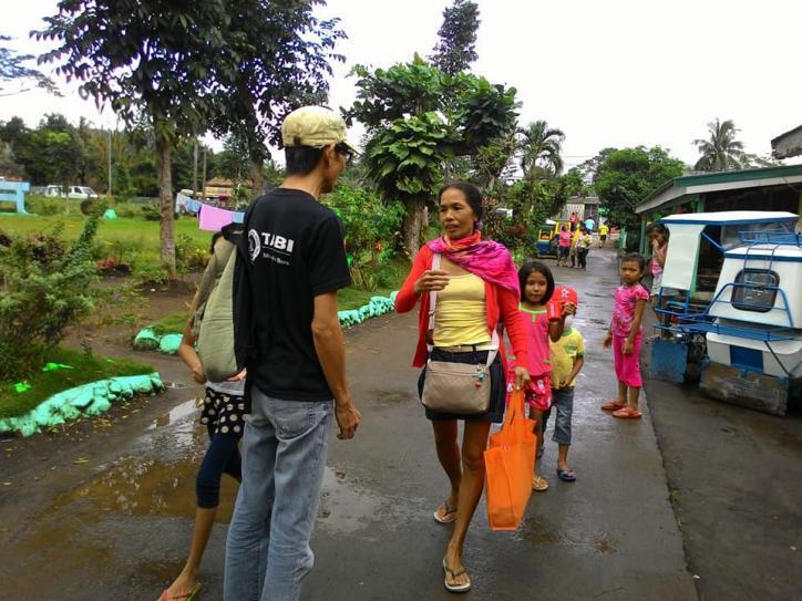
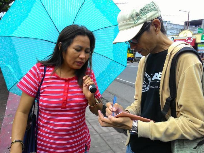
2 Jan , 2018 Continuous lava collapse events, episodes of tremor, rockfall events, pyroclastic density currents (flows of searing hot gas, ash and rocks) and ash clouds were recorded. Alert Level 3 remained in effect. Jan. 22, 2018 PHIVOLCS raised Alert Level No. 4 (hazardous eruption imminent) as lava fountains as high as 200m-500m and more voluminous lava flow were observed. The Danger Zone is extended to 8-kilometer radius. Volcanic ash posed threat to aircrafts flying close to the volcano s summit. Jan. 23, 2018 Mayon s seismic monitoring network recorded two explosion-type earthquakes corresponding to five-kilometer vertical column eruptions, 15 tremor events some of which corresponded to lava fountains as high as 500m to 700m, 35 rockfall events and two pyroclastic density currents. Lava flows from the summit crater advanced to three kilometres from the Miisi Gully and 200 meters from the Bonga-Buyuan Gully. An average of 992 tonnes/day sulphur dioxide emission was measured. Key findings of the rapid assessment conducted by Tarabang para sa Bikol, Inc. (TABI) during the first week of evacuation: Figure 2 TABI staff conducting rapid assessment
3

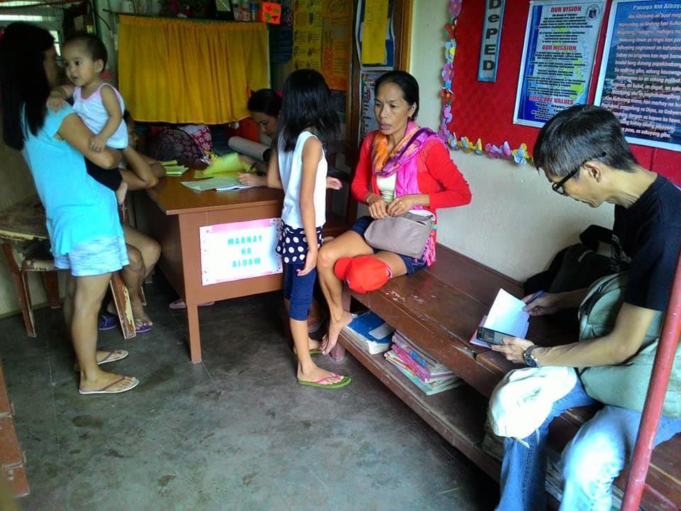
4 Evacuees complain of inadequate food supply. As of January 20, in 4 evacuation sites, an average of only 10 kilos of rice was rationed during the first 7 days of the evacuation period. Inadequate hygiene supplies was also noted. No income source for families to address non-food needs like transportation, educationalneeds of students, and household supplies. Some evacuation centers lack sanitary kitchen facility, bathrooms and toilets. Overcrowding is common families would usually share 1 regular-sized classroom. Most evacuation centers have enough drinking water supply. However, domestic water supply is limited. Evacuees with small water containers/pails are not able to store enough water. Some evacuation centers are not safe from ashfall. TABI Response Distribution of plastic sheets. The plastic sheets will be used as temporary roof cover and partitions for privacy at Taladong Elementary School and Comon Elementary School in Camalig, Albay. Plastic sheets are from the Asia-Pacific Alliance for Disaster Management (A-PAD). Figure 3 Plastic sheets from A-PAD distributed to evacuees. The Disaster Preparedness Committee (TABI-DPC)

5 at Taladong Elem School will ensure proper installation of the plastic sheet roofing. Hot Meals Delivery. One set of kitchen utensils is stationed at Taladong Elementary School. The DPC of Barangay Sua and Barangay Sua will manage the Hot Meals Kitchen. Another set of kitchen utensils is for the mobile kitchen intended for evacuation centers without TABI-DPC. Figure 4 TABI Disaster Preparedness Committee (DPC) of Brgy. Tumpa, Camalig temporarily staying at Taladong ES thankfully receives the Hot Meals kitchen utensils from Mercy Relief thru CDRC. Partnership with private sector. A-PAD Metro Naga, composed of local business sector, academe, media and religious sectors has started its fund raising for Mayon.

 and call for")
6 Figure 5 A-PAD Metro Naga convenes to discuss the "A-PAD for Mayon" emergency response Continuous damage, needs, capacities assessment (DNCA) and call for donations.
7 References: 1. NDRRMC Situational Report on Mayon 2. TABI rapid assessment results
Mayon Volcano Situation Report No January 2018
 Mayon Volcano Situation Report No. 2 26 January 2018 Figure 1 Mayon eruption, Jan. 23, 2018 at 6pm Situation Overview Jan. 13, 2018 - PHIVOLCS raised Alert Level 1 (abnormal) when Mayon Volcano generated
( ) USGS (United States Geological Survey) Watch Green. Normal. alert level 1 Normal
 USGS (United States Geological Survey) Watch Green. Normal. alert level 1 Normal") (200610.1) USGS (United States Geological Survey) 1014 alert level 1 Normal Watch Green Normal USGS WARNING WATCH ADVISORY NORMAL SUMMARY OF VOLCANIC-ALERT LEVELS Highly hazardous eruption underway or
(200610.1) USGS (United States Geological Survey) 1014 alert level 1 Normal Watch Green Normal USGS WARNING WATCH ADVISORY NORMAL SUMMARY OF VOLCANIC-ALERT LEVELS Highly hazardous eruption underway or
Kadovar Eruption: Multi-Hazard Monitoring and Response
 2018/SOM1/EPWG/016 Agenda Item: 11.10 Kadovar Eruption: Multi-Hazard Monitoring and Response Purpose: Information Submitted by: Papua New Guinea 13 th Emergency Preparedness Working Group Meeting Port
VOLCANO MONITORING PRACTICAL. Hazard alert levels established for communication at Mt. Pinatubo
 VOLCANO MONITORING PRACTICAL Predicting volcanic eruptions is a hazardous and stressful business. If an eruption has occurred and was not predicted then the volcanologists get the blame for not giving
Name: Page 1. 2) What do increases and decreases in RSAM data indicate about magma movement inside the volcano?
 What do increases and decreases in RSAM data indicate about magma movement inside the volcano?") Name: Page 1 Living on the Edge Unit 5: SEISMOLOGISTS A report on the seismic activity must be prepared in order to assess and forecast future activity. Complete the following components of the seismology
Name: Page 1 Living on the Edge Unit 5: SEISMOLOGISTS A report on the seismic activity must be prepared in order to assess and forecast future activity. Complete the following components of the seismology
Monthly Volcanic Activity Report (March 2013)
") Monthly Volcanic Activity Report (March 2013) Hakoneyama (Alert Level: 1) Shallow earthquake activity from the area near Mt. Komagatake to Sengokuhara has largely remained at low levels since the middle
Monthly Volcanic Activity Report (March 2013) Hakoneyama (Alert Level: 1) Shallow earthquake activity from the area near Mt. Komagatake to Sengokuhara has largely remained at low levels since the middle
Also, when Cascade volcanoes do erupt, high-speed avalanches of pyroclastic flows
 INTRODUCTION A volcano is a vent through which molten rock escapes to the Earth s surface. Unlike other mountains, which are pushed up from below, volcanoes are built by surface accumulation of their eruptive
Volcanoes. Introduction
 Volcanoes Introduction Display Slide V-0 Explain that a volcano is a vent through which molten rock escapes to the Earth s surface. Unlike other mountains, which are pushed up from below, volcanoes are
Monthly Volcanic Activity Report (March, 2011)
") Monthly Volcanic Activity Report (March, 2011) Japan Meteorological Agency Yakedake[ Alert Level : 1] Just after "The 2011 off the Pacific coast of Tohoku Earthquake" on 11th March, seismicity became higher
Monthly Volcanic Activity Report (March, 2011) Japan Meteorological Agency Yakedake[ Alert Level : 1] Just after "The 2011 off the Pacific coast of Tohoku Earthquake" on 11th March, seismicity became higher
Situation Report. Situation Overview. Volcanic Activity Ambae & Ambrym. Situation Report 08. Time & Date 17:00 18 th October 2017
 Situation Report Response Name Volcanic Activity Ambae & Ambrym Situation Report 08 Time & Date 17:00 18 th October 2017 Reporting period 18/10/2017 Provinces affected Penama, Sanma, Malampa Attachment(s)
NADJNAL DISASTER RISK REDUCOON AND BNAGEIENT OOUNCIL
 REPUBLIC OF THE PHILIPPINES NADJNAL DISASTER RISK REDUCOON AND BNAGEIENT OOUNCIL National Disaster Risk Reduction and Management Center, Camp Aguinaldo, Quezon Ci I, Philippines NDRRMC UPDATE SitRep No.
NAtiONAL DISASlER RISK RED~N AND MANAGEMENT COUNQl
 REPUBLIC OF THE HILIPPINES NAtiONAL DISASlER RISK RED~N AND MANAGEMENT COUNQl National Disaster Risk Reduction and Management Center, Camp Aguinaldo, Quezon City, Philippines NDRRMC UPDAt E SitRep No.
Eruption notifications: II. EFFECTS. A. Pre-Emptive Evacuation (TAB B)
") Eruption notifications: Date and Time 29 January 2018, 8:16 PM 29 January 2018, 10:45 PM II. EFFECTS Estimated Height of Ash/steam Plume Cloud A. Pre-Emptive Evacuation (TAB B) 2 Remarks No visual observation
Eruption notifications: Date and Time 29 January 2018, 8:16 PM 29 January 2018, 10:45 PM II. EFFECTS Estimated Height of Ash/steam Plume Cloud A. Pre-Emptive Evacuation (TAB B) 2 Remarks No visual observation
Chapter 5 9/10/2011. Introduction. Volcanoes and Volcanism. Volcanism. Introduction. Introduction. Introduction
 Introduction Chapter 5 Volcanism is the eruption of magma, and associated gases at the surface. Some magma erupts explosively as pyroclastic (fire-broken) rock and other erupts as lava flows. Volcanoes
Volcanoes. Volcanoes July 2004
 Volcanoes Learn about your community s risk from hazards created by volcanic eruptions. While you may be located far from a volcano, the ash from an explosive eruption could affect your area. Contact your
Monthly Volcanic Activity Report (July, 2012)
") Monthly Volcanic Activity Report (July, 2012) Tokachidake [Alert Level: 1] Volcanic glows have been observed in the Taisho crater with a high-sensitivity camera at night from the night of June 30th to
Monthly Volcanic Activity Report (July, 2012) Tokachidake [Alert Level: 1] Volcanic glows have been observed in the Taisho crater with a high-sensitivity camera at night from the night of June 30th to
Hands-on Activity Predicting Eruptions on Montserrat
 Hands-on Activity Predicting Eruptions on Montserrat Predicting Eruptions No one can predict exactly when a volcano might explode. There are, however, common clues to look for to let people know that the
LECTURE #11: Volcanoes: Monitoring & Mitigation
 GEOL 0820 Ramsey Natural Disasters Spring, 2018 LECTURE #11: Volcanoes: Monitoring & Mitigation Date: 15 February 2018 I. What is volcanic monitoring? the continuous collection of one or more data sources
Virtual Design Center Deliverable 4-2: Three Levels of Assessment
 Virtual Design Center Deliverable 4-2: Three Levels of Assessment Project Name Operation Montserrat Test Questions 1. Which of these is an immediate result of the movement of tectonic plates: a) Ocean
About Volcanoes Volcanology IMPORTANT TERMS
 About Volcanoes IMPORTANT TERMS magma Rock that is molten (in liquid form due to heating). When magma reaches the surface, it is called lava. lava magma reservoir An underground pool that is filled with
Toxic cloud caused by Hawaii volcano lava emerges over ocean 21 May 2018, by Caleb Jones And Audrey Mcavoy
 Toxic cloud caused by Hawaii volcano lava emerges over ocean 21 May 2018, by Caleb Jones And Audrey Mcavoy Joe Kekedi watches as lava enters the ocean, generating plumes of steam near Pahoa, Hawaii Sunday,
Monthly Volcanic Activity Report (February, 2011)
") Monthly Volcanic Activity Report (February, 2011) Japan Meteorological Agency Izu-Oshima[ Alert Level : 1] Earthquakes at the western offshore areas of Izu-Oshima increased on 9 th temporarily in this
Monthly Volcanic Activity Report (February, 2011) Japan Meteorological Agency Izu-Oshima[ Alert Level : 1] Earthquakes at the western offshore areas of Izu-Oshima increased on 9 th temporarily in this
Volcanic Eruptions (pp )
") Name Date Class Volcanic Eruptions (pp. 221 228) This section explains how volcanoes erupt and describes types of volcanic eruptions as well as other types of volcanic activity. The section also describes
Name Date Class Volcanic Eruptions (pp. 221 228) This section explains how volcanoes erupt and describes types of volcanic eruptions as well as other types of volcanic activity. The section also describes
Monthly Volcanic Activity Report (April 2013)
") Monthly Volcanic Activity Report (April 2013) Zaozan (Calm) Small-amplitude volcanic tremors were recorded on April 7 (duration: 3 min 20 sec), 9 (4 min 20 sec) and 21 (5 min 40 sec). These were the first
Monthly Volcanic Activity Report (April 2013) Zaozan (Calm) Small-amplitude volcanic tremors were recorded on April 7 (duration: 3 min 20 sec), 9 (4 min 20 sec) and 21 (5 min 40 sec). These were the first
Volcanoes. Environmental Geology, Mr. Paul Lowrey Stacey Singleton, Cassandra Combs, Dwight Stephenson, Matt Smithyman
 Volcanoes Environmental Geology, Mr. Paul Lowrey Stacey Singleton, Cassandra Combs, Dwight Stephenson, Matt Smithyman EMPACTS Project, Spring 2017 Northwest Arkansas Community College, Bentonville, AR
GEOLOGIC HAZARDS AND DISASTER REDUCTION EFFORTS IN THE PHILIPPINES
 GEOLOGIC HAZARDS AND DISASTER REDUCTION EFFORTS IN THE PHILIPPINES 23 rd Asia-Pacific Advanced Network Meeting January 22-26, 2007 Renato U. Solidum Jr Director Philippine Institute of Volcanology and
C. Livestock Evacuation 1. A total of 681 livestocks were evacuated in Pooling Stations in the Province of Albay.
 B. Affected Population 1. As of 6:00 AM, 03 February 2018, a total of 21,723 families / 83,671 persons were affected in 61 barangays in the municipalities/cities of Bacacay, Camalig, Guinobatan, Ligao
Scientists: Explosive eruption risk rises for Hawaii volcano 10 May 2018, by Sophia Yan And Audrey Mcavoy
 Scientists: Explosive eruption risk rises for Hawaii volcano 10 May 2018, by Sophia Yan And Audrey Mcavoy Hawaii Gov. David Ige said a geothermal energy plant near the lava outbreak was accelerating its
Contribution of Sentinel Asia Activities to Disaster Management in Asia Pacific Region: Sentinel Asia Success Story in the Philippines Project
 Contribution of Sentinel Asia Activities to Disaster Management in Asia Pacific Region: Sentinel Asia Success Story in the Philippines Project Arturo Daag PHIVOLCS, PHILIPPINES 13 October 2015 Bangkok
Aim: To be able to describe and explain techniques used to predict or reduce the impacts of volcanic eruptions in NAMED locations.
 C/W Qu: Can we predict volcanoes? 18/10/12 Aim: To be able to describe and explain techniques used to predict or reduce the impacts of volcanic eruptions in NAMED locations. Starter: Read and correct the
Volcanism (Chapter 5)
") GEOLOGY 306 Laboratory Instructor: TERRY J. BOROUGHS NAME: Volcanism (Chapter 5) For this assignment, you will require: a calculator, colored pencils, string, protractor, stereoscopes (provided). Objectives
GEOLOGY 306 Laboratory Instructor: TERRY J. BOROUGHS NAME: Volcanism (Chapter 5) For this assignment, you will require: a calculator, colored pencils, string, protractor, stereoscopes (provided). Objectives
Problems Associated with Activity Assessment, Dissemination of Information, and Disaster Response During the 2000 Eruption of Miyakejima
 Problems Associated with Activity Assessment, Dissemination of Information, and Disaster Response During the 2000 Eruption of Miyakejima Hidefumi WATANABE * 1. Introduction Volcanic hazard mitigation requires
EAS 116 Earthquakes and Volcanoes
 EAS 116 Earthquakes and Volcanoes J. Haase Forecasting Volcanic Eruptions Assessment of Volcanic Hazard Is that volcano active? Mount Lassen: 12000 BP and 1915 Santorini, IT: 180,000 BP, 70,000 BP, 21000
From Punchbowl to Panum: Long Valley Volcanism and the Mono-Inyo Crater Chain
 From Punchbowl to Panum: Leslie Schaffer E105 2002 Final Paper Long Valley Volcanism and the Mono-Inyo Crater Chain Figure 1. After a sequence of earthquakes during the late 1970 s to the early 1980 s
Chapter 5 THE DEVELOPMENT OF VOLCANIC EMERGENCY PLANS. 5.1 Introduction
 Chapter 5 THE DEVELOPMENT OF VOLCANIC EMERGENCY PLANS 5.1 Introduction It will be assumed in this chapter: (0) That in any community exposed to volcanic hazards there is general awareness of the hazard
Predicting and Preparing for Volcanoes
 Predicting and Preparing for Volcanoes Prediction methods for volcanic eruptions are more reliable than those for earthquakes. Some volcanoes such as Mount Etna in Italy are monitored all of the time because
Monthly Volcanic Activity Report (April 2015)
") Monthly Volcanic Activity Report (April 2015) Japan Meteorological Agency Meakandake (Alert Level: 1) The number of small shallow earthquakes occurring near the Ponmachineshiri crater increased from 15
Monthly Volcanic Activity Report (April 2015) Japan Meteorological Agency Meakandake (Alert Level: 1) The number of small shallow earthquakes occurring near the Ponmachineshiri crater increased from 15
Juban is faced with several major, major,major,major, major Natural Disasters and Hazards..
 Juban Hazards Juban Disaster Risk Reduction and Management Council (JMDRRMC) Juban Hazard Profile Juban is faced with natural multigeohazards / disasters. >>> Typhoons / Floods Bicol Region typhoon belt
Hazard assessment: Auckland Volcanic Field
 Hazard assessment: Auckland Volcanic Field Jan Lindsay SGGES & Institute of Earth Science and Engineering Hazard assessment The use of all available tools to determine the location, intensity, frequency
Living on the Edge: Unit3: Convergent Plate Boundaries
 Living on the Edge: Unit3: Convergent Plate Boundaries Because of its eleva.on (4,392 m), relief, hydrothermal altera.on, ice cap, glacier- fed radial valleys, and proximity to suburbs of the SeaBle- Tacoma
3.2 Notes: Volcanoes Form as Molten Rock Erupts
 3.2 Notes: Volcanoes Form as Molten Rock Erupts Think about What happens when a volcano erupts? Volcanoes erupt many types of material Earth s thin outer layer is, but most of Earth is extremely hot rock
Hazards Caucus Alliance Briefing
 Monitoring Volcanoes: Reducing the Risks of Volcanic Hazards for Society Hazards Caucus Alliance Briefing June 25, 2018 Charlie Mandeville USGS Volcano Hazards Program Coordinator cmandeville@usgs.gov
Module 1, Investigation 3: Predicting Eruptions
 Module 1, Investigation 3: Predicting Eruptions Introduction Welcome! Volcanoes are either "active" or "extinct". Active means that the volcano has erupted during the past 10,000 years. It can also mean
Ash Plumes. Teacher Instructions. Overview: Objectives: National Standards: Alaska Grade Level Expectations Addressed:
 Teacher Instructions Ash Plumes Overview: Composite volcanoes usually erupt with large clouds of ash, called ash plumes. Volcanologists track ash plumes and relay the information to air traffic controllers
Physical Geography. Tectonics, Earthquakes, and Volcanism. Chapter 12 GEOGRAPHY Earthquakes and Volcanoes. What are Earthquakes?
 Physical Geography GEOGRAPHY 1710 DAVID R. SALLEE Tectonics, Earthquakes, and Chapter 12 Earthquakes and Volcanoes Earthquakes? The shaking or trembling caused by the sudden release of energy Usually associated
Monthly Volcanic Activity Report (February 2016)
") Monthly Volcanic Activity Report (February 2016) Japan Meteorological Agency Azumayama (Alert Level: 2) Fumarolic activity at the Oana crater has remained at relatively high levels. Aerial observation
Monthly Volcanic Activity Report (February 2016) Japan Meteorological Agency Azumayama (Alert Level: 2) Fumarolic activity at the Oana crater has remained at relatively high levels. Aerial observation
GRADE VI BEING PREPARED DURING VOLCANIC ACTIVITIES
 GRADE VI BEING PREPARED DURING VOLCANIC ACTIVITIES At the end of the module, you should be able to: Differentiate an active from an inactive volcano Describe the harmful effects of a volcanic eruptions
Overview of Philippine Geohazards Programs
 Overview of Philippine Geohazards Programs 53 rd CCOP Annual Session CCOP-IUGS Task Group on Geohazards Joint Seminar Cebu City, PHILIPPINES October 18, 2017 Renato U. Solidum, Jr. Department of Science
Kīlauea Volcano: Be a Volcanologist. Image Credit: Julien Millet / Unsplash. Final Project
 The Kīlauea Volcano: Be a Volcanologist Image Credit: Julien Millet / Unsplash Final Project Final Project The Kīlauea Volcano: Be a Volcanologist In this two-day project, students apply their previous
Take a Chance on the volcano erupting How hazardous is the volcano?
 Earthlearningidea - http://www.earthlearningidea.com/ Take a Chance on the volcano erupting How hazardous is the volcano? Earth Learning Idea has already published Party time for volcanoes! How much force
Unit 1 Dynamic Planet Topic 1 Restless earth
 Unit 1 Dynamic Planet Topic 1 Restless earth Instructions Complete this revision sheet using your exercise book and text book. Store this revision sheet in your revision folder once it has been checked
Land-use planning and volcanic hazards: Opportunities for New Zealand
 Land-use planning and volcanic hazards: Opportunities for New Zealand Julia Becker, Wendy Saunders, Graham Leonard, David Johnston, Lower Hutt Clare Robertson, Massey University, Palmerston North Presentation
Released Science Inquiry Task Encounter with an Active Volcano Grade 11
 Date: Your Name: Released Science Inquiry Task Encounter with an Active Volcano 2016 Grade 11 Directions: Science You will be reading a story and analyzing the data provided to answer a set of questions.
FIRST GRADE HAZARDS 1 WEEK LESSON PLANS AND ACTIVITIES
 FIRST GRADE HAZARDS 1 WEEK LESSON PLANS AND ACTIVITIES PLATE TECTONIC CYCLE OVERVIEW OF FIRST GRADE VOLCANOES WEEK 1. PRE: Learning the shapes of volcanoes. LAB: Experimenting with "lava." POST: Comparing
 Pliny said the plume (tephra) looked like an umbrella pine tree... Pliny said the plume (tephra) looked like an umbrella pine tree... WOULD YOU SURVIVE? WARNING SIGNS 1) What would have been
Debris Avalanches. Debris avalanche deposits on a volcano in Chile. All of the area in the foreground is buried by a thick debris avalanche.
 Debris Avalanches Volcanoes are not very stable structures. From time to time, they collapse producing large rock and ash avalanches that travel at high speeds down valleys. Collapse maybe caused by an
HAZARD IDENTIFICATION AND VULNERABILITY ANALYSIS (HIVA) Walla Walla County, Washington VOLCANO ASH FALL
 Walla Walla County, Washington VOLCANO ASH FALL") HAZARD IDENTIFICATION AND VULNERABILITY ANALYSIS (HIVA) Walla Walla County, Washington VOLCANO ASH FALL Hazard Overview A volcano is a vent in the earth's crust through which magma (molten rock), rock
HAZARD IDENTIFICATION AND VULNERABILITY ANALYSIS (HIVA) Walla Walla County, Washington VOLCANO ASH FALL Hazard Overview A volcano is a vent in the earth's crust through which magma (molten rock), rock
Monthly Volcanic Activity Report (August 2015)
") Monthly Volcanic Activity Report (August 2015) Japan Meteorological Agency Meakandake (Alert Level: 2) Volcanic seismicity in shallow parts under the area around the Ponmachineshiri crater began to fluctuate
Monthly Volcanic Activity Report (August 2015) Japan Meteorological Agency Meakandake (Alert Level: 2) Volcanic seismicity in shallow parts under the area around the Ponmachineshiri crater began to fluctuate
ERUPTION! A VOLCANIC CRISIS SIMULATION
 ERUPTION! A VOLCANIC CRISIS SIMULATION INTRODUCTION Eruption! is a model or simulation in the form of a computer program, which simulates a fifty day period of volcanic activity at a potentially hazardous
Year 9 Revision. The exam will be based on two topics: Natural hazards and Population. The Exam
 Year 9 Revision The exam will be based on two topics: Natural hazards and Population This document is designed to help you revise. You should use it alongside your class notes. In places there are some
A New College in Orting?
 A New College in Orting? Risk Report and Recommendation by: Safe Schools Kause Everyone Deserves (SSKED) 2017 Geographic location and physical site of Orting The city of Orting is located in Pierce county,
Unit 4 Lesson 4 Volcanoes. Copyright Houghton Mifflin Harcourt Publishing Company
 Magma Magic What is a volcano? A volcano is any place where gas, ash, or melted rock come out of the ground. Many volcanoes are dormant, meaning an eruption has not occurred in a long period of time. What
A - Piton de la Fournaise activity
 OVPF-IPGP August 2018 Page 1/7 Monthly bulletin of the Piton de la Fournaise Volcanological Observatory ISSN ISSN 2610-5101 A - Piton de la Fournaise activity PITON DE LA FOURNAISE (VNUM #233020) Latitude:
and their risks A look at volcano risk for young students. Produced by the MED-SUV project.
 and their risks A look at volcano risk for young students. Produced by the MED-SUV project. Volcano Shapes: A volcano is a place (on Earth and OTHER PLANETS) where magma comes to the surface. This event
Why was this eruption important?
 Mount St. Helens Mount St. Helens has a long geological history (>3,000 yrs) of explosive eruptions. The 1980 Events: Initial relatively mild steam and ash (Vulcanian) eruptions. Sustained plinian eruption
Volcanoes. volcanic hazards. Image courtesy of USGS.
 Volcanoes volcanic hazards Volcanic hazards Pyroclastic flows and surges Pyroclastic flows and surges PYROCLAST: all solid fragments ejected from volcanoes PYROCLASTIC FLOW: A flow of hot gas and volcanic
FINAL EXAM December 20 th, here at 1:00 3:00 pm
 FINAL EXAM December 20 th, here at 1:00 3:00 pm REVIEW SESSION December 11 th at 6:00-7:30 pm Morrill I Auditorium (Room N375) Same as last time Don t forget your online course evaluations! Major Volcanic
A bowl shaped depression formed by the collapse of a volcano is called a. Magma that has left the vent of a volcano is known as. Lava.
 Magma that has left the vent of a volcano is known as Lava A bowl shaped depression formed by the collapse of a volcano is called a Caldera This can form in a caldera when magma starts to come back up
Component 1, Topic 1: Hazardous Earth [PLC]
![Component 1, Topic 1: Hazardous Earth [PLC]](/thumbs/80/82218752.jpg "Component 1, Topic 1: Hazardous Earth [PLC]") Hazardous Earth - Earth's Structure and Tectonic Processes Revision Booklet Component 1, Topic 1: Hazardous Earth [PLC] From 1-5 rank how confident you are for each argument. 1= not confident at all /
Hazardous Earth - Earth's Structure and Tectonic Processes Revision Booklet Component 1, Topic 1: Hazardous Earth [PLC] From 1-5 rank how confident you are for each argument. 1= not confident at all /
Interpretive Map Series 24
 Oregon Department of Geology and Mineral Industries Interpretive Map Series 24 Geologic Hazards, and Hazard Maps, and Future Damage Estimates for Six Counties in the Mid/Southern Willamette Valley Including
! Profile of Mauna Loa in Hawaii. Mauna Loa is one of five huge shield volcanoes that make up the island of Hawaii.
 - Shield Volcanoes - Low, rounded profiles; slope angles 2-10 ; composed of numerous flows of mafic composition and little explosive activity - Largest of all volcanoes! Shield volcanoes consist of numerous
Case History: Mt. St. Helens
 Case History: Mt. St. Helens EAS 458 Volcanology Introduction 1980 eruption of Mt. St. Helens was particularly interesting and violent eruption with an unusual lateral blast. In the 1970 s, the USGS (Crandell(
Tracking Ash Plumes. Teacher Instructions. Overview: Objectives: Materials: Answers to Student Worksheet:
 Teacher Instructions Tracking Ash Plumes Overview: Composite volcanoes usually erupt with large clouds of ash, called ash plumes. Volcanologists track ash plumes and relay the information to air traffic
NSF-MARGINS Expedition to Anatahan Volcano March 2005
 1 NSF-MARGINS Expedition to Anatahan Volcano March 2005 According to the Emergency Management Office (EMO) report distributed in February 2005, the third historical eruption of Anatahan began on January
GEOLOGY MEDIA SUITE Chapter 12
 UNDERSTANDING EARTH, SIXTH EDITION GROTZINGER JORDAN GEOLOGY MEDIA SUITE Chapter 12 Volcanoes 2010 W.H. Freeman and Company Plate tectonics explains the global pattern of volcanism. Key Figure 12.20 (page
Volcanic Hazards in Guatemala Dr. Matt Watson School of Earth Sciences
 Volcanic Hazards in Guatemala Dr. Matt Watson School of Earth Sciences Presentation to the Bristol Branch of the Geographical Association in September 2018 Image credit: Albert Dros. www.albertdros.com
Montserrat Eruption = Monster rat
 Montserrat Eruption 1997 = Monster rat Small island in the Caribbean sea Montserrat is a small... Soufriere Hills volcano Key facts: Date: 25 th June 1997 (small eruptions began in July 1995) Size: 4.5
Earthquakes and Society
 CHAPTER 8 SECTION 3 Earthquakes Earthquakes and Society BEFORE YOU READ After you read this section, you should be able to answer these questions: Can scientists predict when earthquakes will happen? Why
Living on the Edge: Unit 5: Convergent Plate Boundaries
 Living on the Edge: Unit 5: Convergent Plate Boundaries Because of its eleva.on (4,392 m), relief, hydrothermal altera.on, ice cap, glacier- fed radial valleys, and proximity to suburbs of the SeaBle-
Monthly Volcanic Activity Report (November 2015)
") Monthly Volcanic Activity Report (November 2015) Japan Meteorological Agency Meakandake (Alert Level: 1) Alert level downgrade from 2 to 1 on 13 November A field survey conducted from 2 to 5 November showed
Monthly Volcanic Activity Report (November 2015) Japan Meteorological Agency Meakandake (Alert Level: 1) Alert level downgrade from 2 to 1 on 13 November A field survey conducted from 2 to 5 November showed
Key Stage 4 - Volcano Eruption! Task sheet: phase 1
 Task sheet: phase 1 Rotimon is an imaginary island. La Soufriere is its youngest volcano. It last erupted in the 1970s. It is not monitored at the moment. Recently the volcano has shown some strange signs.
Volcanic Disaster Mitigation for Living in Harmony with Active Volcanoes
 Volcanic Disaster Mitigation for Living in Harmony with Active Volcanoes SURONO Expert Staf of Ministry of Energy and Mineral Resources, Republic of Indonesia Presented on : The 9 th International Graduate
SEISMIC DATA SET 2 (THROUGH JUNE 12)
") Living on the Edge: Unit 6 Prework, Hazards and Risks at Convergent Plate Boundaries SEISMIC DATA SET 2 (THROUGH JUNE 12) Note: you only need to examine/describe the same type of data you used during the
Living on the Edge: Unit 6 Prework, Hazards and Risks at Convergent Plate Boundaries SEISMIC DATA SET 2 (THROUGH JUNE 12) Note: you only need to examine/describe the same type of data you used during the
Seismic Retrofit R-Us Laura Branch Earnest Righetti High School Grade Level: 9-12 Subject Area: Earth Science/Geology
 Seismic Retrofit R-Us Laura Branch Earnest Righetti High School Grade Level: 9-12 Subject Area: Earth Science/Geology Project Summary: The world is shaking!!! Why? Why is there so much damage to buildings
Recent activity. Current episode 12 years Transition between styles 4 periods of dome growth Since 2003, Vulcanian explosions (4 25 per day)
") Recent activity Current episode 12 years Transition between styles 4 periods of dome growth Since 2003, Vulcanian explosions (4 25 per day) 02 December 09 Explosions originating from dome e.g. 10 Jan 2010
Recent activity Current episode 12 years Transition between styles 4 periods of dome growth Since 2003, Vulcanian explosions (4 25 per day) 02 December 09 Explosions originating from dome e.g. 10 Jan 2010
19. Esan Continuously Monitored by JMA
 19. Esan Continuously Monitored by JMA Latitude: 41 48'17" N, Longitude: 141 09'58" E, Elevation: 618 m (Esan) (Triangulation Point) Overview of Esan, taken from east side on March 13, 2009 by the Japan
Pavlof. Alaska Peninsula N, W; summit elev. 2,519 m. All times are local (= UTC - 9 hours)
") Pavlof Alaska Peninsula 55.42 N, 161.887 W; summit elev. 2,519 m All times are local (= UTC - 9 hours) Eruption in May-June 2013 with lava flows and ash emissions to ~8.5 km a.s.l. Pavlof, the most active
Pavlof Alaska Peninsula 55.42 N, 161.887 W; summit elev. 2,519 m All times are local (= UTC - 9 hours) Eruption in May-June 2013 with lava flows and ash emissions to ~8.5 km a.s.l. Pavlof, the most active
Degassing processes and recent activity at Volcán de Colima. Universidad de Colima, Mexico Corresponding author
 Degassing processes and recent activity at Volcán de Colima Nick Varley * & Gabriel Reyes Dávila Universidad de Colima, Mexico Corresponding author email: nick@ucol.mx Volcán de Colima is currently in
Get in Touch with Tapasvi IAS
 Barren Island Volcano Erupted Again, Facts About Barren Island Get in Touch with Tapasvi IAS Join us on Facebook for daily updates and important material for UPSC Join Now Join our Telegram Channel and
Erupted and killed approximately 15,000 people 200 years ago
 1 2 3 4 5 6 7 8 Introduction to Environmental Geology, 5e Chapter 8 Volcanic Activity Volcanoes: summary in haiku form A volcano forms. Magma comes to the surface - explodes, if felsic. Case History: Mt.
Coordinated Monitoring of Ash Eruptions in the Russian Far East and Alaska
 Coordinated Monitoring of Ash Eruptions in the Russian Far East and Alaska Dr. John Eichelberger, Program Coordinator, Volcano Hazards Program, US Geological Survey, Reston, Virginia, USA Academician Evgeny
Ch12&13 Test. 3. Where does the first motion of an earthquake occur? a. fault c. epicenter b. focus d. locus
 Ch12&13 Test Multiple Choice Identify the choice that best completes the statement or answers the question. 1. What is the epicenter of an earthquake? a. the location along a fault where the first motion
CHAPTER 2 NOTES -FOUNDATIONS OF GEOLOGY-
 CHAPTER 2 NOTES -FOUNDATIONS OF GEOLOGY- LESSON 2.1A: LAYERS OF THE EARTH GEOLOGY Geology- LAYERS OF THE EARTH Earth has 3 major layers based on their composition: o - the outer layer, made of solid rock.
Growth of International Collaboration in Monitoring Volcanic Ash Eruptions in the North Pacific
 Growth of International Collaboration in Monitoring Volcanic Ash Eruptions in the North Pacific John C. Eichelberger and Christina Neal U.S. Geological Survey U.S. Department of the Interior U.S. Geological
FOUNDATIONS OF GEOLOGY CHAPTER 2
 FOUNDATIONS OF GEOLOGY CHAPTER 2 2.3A- VOLCANOES Volcanoes all share common characteristics. Vent- a central channel through which gases, ash and rock are ejected. Magma- molten rock which lies several
Visualizing Earth Science. Chapter Overview. Volcanoes and Eruption Types. By Z. Merali and B. F. Skinner. Chapter 9 Volcanism and Other
 Visualizing Earth Science By Z. Merali and B. F. Skinner Chapter 9 Volcanism and Other Igneous Processes Volcanoes types and effects of eruption Chapter Overview Melting and cooling of rocks Geological
Overview of Ch. 4. I. The nature of volcanic eruptions 9/19/2011. Volcanoes and Other Igneous Activity Chapter 4 or 5
 Overview of Ch. 4 Volcanoes and Other Igneous Activity Chapter 4 or 5 I. Nature of Volcanic Eruptions II. Materials Extruded from a Volcano III.Types of Volcanoes IV.Volcanic Landforms V. Plutonic (intrusive)
Pyroclastic Flows. Lesson 6
 Pyroclastic Flows Lesson 6 P yroclastic flows are one of the most dangerous natural events that occur on our planet. They can at hurricane speeds down the slopes of a mountain, destroying everything in
Monitoring Volcanoes. An introduction to monitoring techniques. Name: Class: Date:
 Monitoring Volcanoes An introduction to monitoring techniques Name: Class: Date: Aims To understand how volcanoes are monitored in order to predict when they will erupt To understand the importance of
Latitude: 43 25'03" N, Longitude: '52" E, Elevation: 1,692 m (Maruyama) (Triangulation Point)
 (Triangulation Point)") 8.Maruyama Latitude: 43 25'03" N, Longitude: 143 01'52" E, Elevation: 1,692 m (Maruyama) (Triangulation Point) Overview of Maruyama taken from northwest side on July 2, 2007 by the Japan Meteorological
8.Maruyama Latitude: 43 25'03" N, Longitude: 143 01'52" E, Elevation: 1,692 m (Maruyama) (Triangulation Point) Overview of Maruyama taken from northwest side on July 2, 2007 by the Japan Meteorological