GIS data models: how to georeference a farm? Nicola Ferrè
|
|
|
- Moris Bell
- 5 years ago
- Views:
Transcription


1 GIS data models: how to georeference a farm? Nicola Ferrè
2 The spatial characteristics of an object..there are many ways to spatially describe a farm.. definition Observer 1 Observer 2 any establishment, construction or, in the case of an open-air farm, any place in which animals are held, kept or handled the whole area and all infrastructures on it under the control of an operator to perform agricultural or aquaculture activities granularity 1 spatial element >1 spatial element primitive point polygon scalable same shape for whole scales multi-scale spatial represetnation

3 The spatial characteristics of an object Definition: In order to be able to represent an object inside a GIS, we first need to define what we are referring to. Granularity: Granularity is a level of details. Granular objects are those, which are at low level detail in your GIS Primitive: A graphic representation of a location Scalability: Scale affects the degree of generalization of features being mapped.
4 The spatial characteristics of an object..there are many ways to spatially describe a farm....we need an information model to represent an object in a GIS software, in order to.. 1. capture and precisely state requirements to represent the object so that all stakeholders may understand and agree about them, 2. think about the design of the system, process, and the tool that will be used to capture the information, 3. explore multiple solutions also from the economical point of view.
5 The spatial characteristics of an object What is an information model and why do you need one? 1. An Information Model provides the framework for organizing your content so that it can be delivered and reused 2. The framework assists authors and users in finding what they need Once you have created an Information Model for your content repository, you will be able to label information in ways that will enhance search and retrieval


6 Information model From a geomatics point of view, an information model allows the user to create a representation of how an object looks on a GIS software Definition Spatial characteristic Choose the primitive and attributes
7 Information model Definition:..in natural language.. [..] any place in which animals are held, kept or handled [..] [..] spatial information on zones where specific management, restriction or regulative regimes are established [..] establishing a dictionary of the terminology used giving some examples (e.g. photos, drawings) to exemplify the concept
8 Information model Spatial characteristic: to consider only the essential spatial elements that characterize the object o some element must be ignored (e.g.: silos, farmer house) o some other identified (e.g.: building, shelters, plots)..you should choose which is the relevant spatial characteristic of the object according to your interest. Remember: features are often "vague, gradual, or fuzzy"

9 Information model
10 Information model Primitive & attribute - accuracy Accuracy: Detail with which features are represented (both spatial and properties). Elements to consider: what you intend doing with the feature grain and extent (scale) costs of capturing and maintaining the feature
11 Information model Primitive & attribute - usage Typical spatial information usage:.. just to produce a simple map of the.. Object inventory Spatial calculation (e.g.: distance, surface) Spatial analysis (e.g.: spatial density, hot spot)


12 Information model Primitive & attribute - scale Map scale affects map detail a larger scale map can show more detail than a smaller scale map. Information content is correlated with grain and extent Grain: is the size of the individual units of observation; i.e., the finest unit of management Extent: is the spatial domain over which the system is studied and for which data are available
13 Information model Primitive & attribute Generalisation vs Abstraction Generalisation: Generalization is the method used in GIS to reduce detail in data (by removing details, a geographic feature become simplified) Abstraction: A simplified idea of a realworld object
14 Information model Primitive & attribute Generalisation vs Abstraction With the abstraction process we simultaneously focus on important characteristics of geographic content, structure, and process while temporarily suppressing certain details, rather than on the elimination or deletion of details (generalisation).
15 Information model Primitive & attribute - costs As scale gets larger, accuracy gets better, and cost increases Decide on a map accuracy that meets your requirements and that you can afford
 an information model Take home message # 2 An information model is based")
16 Take home message # 1 Before to start to collect geospatial data you need to define (clearly) an information model Take home message # 2 An information model is based on:
17 Take home message # 3 Scale, cost, and accuracy are inseparably intertwined Content accuracy: imprecise definition Spatial accuracy: incoherent spatial representation Attribute accuracy: wrong proprieties Take home message # 4 Abstraction and generalization are fundamental to define the way to represent an object..consider ALWAYS the costs for data production and management..
18 Information model Questions?
19 Information model practical example Goal: to georeference the farms of an area in Italy to produce a farm distribution map Step 1: Definition I do not need to provide a farm definition that is suitable for every circumstance inside and outside the veterinary domain, I need a definition that is specifically thought for the spatial element of farms and for the identified goal
20 Information model practical example farm: an area organised by an operator to perform activities related to animal keeping To improve the consensus of this definition I can refer to legislation, or scientific publications
21 Information model practical example farm: an area organised by an operator to perform activities related to animal keeping Dictionary [..] Area. surface specialised for animal keeping. Specifically, land parcels organised for animal confinement. This area can consist of permanent or semi-permanent structures such as buildings, shelters, etc.. or it can be delimited with fences, walls or boundary posts.
![Information model practical example farm: an area organised by an operator to perform activities related to animal keeping Dictionary [..] Area. surface specialised for animal keeping.](/docs-images/83/88428259/images/22-1.jpg "Specifically, land parcels organised for animal confinement. This area can consist of permanent or semi-permanent structures such as buildings, shelters, etc.")
22 Information model practical example farm: an area organised by an operator to perform activities related to animal keeping Dictionary [..] Area. surface specialised for animal keeping. Specifically, land parcels organised for animal confinement. This area can consist of permanent or semi-permanent structures such as buildings, shelters, etc.. or it can be delimited with fences, walls or boundary posts.
23 Information model practical example Step 2: Spatial Characteristic [..] all areas dedicated to animal containment that are characterised by the presence of physical delimitation [..] physical delimitation can be composed of man-made constructions such buildings, shelters, fences, walls, electric fences and natural barriers that functionally are used to contain the animals

24 Information model practical example Step 3: Primitive and attributes Trade off:
25 Information model practical example Step 3: Primitive and attributes Method: Direct vs Indirect Primitive: Polygon vs Point
26 Information model practical example Step 3: Primitive and attributes Data independence principle to assign a code to the farm (join function) to know when the spatial data was captured to know which capture method was used to know who captured the spatial data other geographical ancillary information (e.g.: address)
27 Information model practical example Step 4: evaluate the data quality For a sample of not less than 10% of captured farm evaluate the spatial accuracy by means of a different data capturing method Calculate the error as the distance between the locations obtained by the two different methods for the same object. The mean, the minimum and the maximum distances of the sampled farms provide us a sort of quality value for the collected data
28 Information model practical example Questions?
 Geocoding 2) Direct 3)")
29 How best georeference a farm? 1) Geocoding 2) Direct 3) Indirect

30 How best georeference a farm? - Geocoding
31 How best georeference a farm? - Geocoding You need: Address locator software Background-address map. OpenStreetMap is a collaborative project to create a free editable map of the world (Open Data Commons Open Database License). Google maps must be used according to the Google terms of service
32 How best georeference a farm? - Geocoding

33 How best georeference a farm? - Geocoding


34 How best georeference a farm? - Direct


35 How best georeference a farm? - Direct


36 How best georeference a farm? - Direct

37 How best georeference a farm? - Indirect

38 How best georeference a farm? - Indirect

39 How best georeference a farm? - Indirect
40 How best georeference a farm? Questions?
SITMUN: Cooperating to Build Local SDIs in the Barcelona Region
 SITMUN: Cooperating to Build Local SDIs in the Barcelona Region Diputació de Barcelona Territory and Sustainability Area Territorial Information Systems Department INSPIRE CONFERENCE Barcelona, September
Systems (GIS) - with a focus on.
 - with a focus on.") Introduction to Geographic Information Systems (GIS) - with a focus on localizing the MDGs Carmelle J. Terborgh, Ph.D. ESRI www.esri.com Flying Blind Jul 24th 2003 The Economist We Live in Two Worlds Natural
Introduction to Geographic Information Systems (GIS) - with a focus on localizing the MDGs Carmelle J. Terborgh, Ph.D. ESRI www.esri.com Flying Blind Jul 24th 2003 The Economist We Live in Two Worlds Natural
Data Aggregation with InfraWorks and ArcGIS for Visualization, Analysis, and Planning
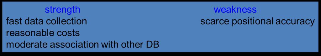
 Data Aggregation with InfraWorks and ArcGIS for Visualization, Analysis, and Planning Stephen Brockwell President, Brockwell IT Consulting, Inc. Join the conversation #AU2017 KEYWORD Class Summary Silos
INSPIRE Basics. Vlado Cetl European Commission Joint Research Centre. https://ec.europa.eu/jrc/
 INSPIRE Basics Vlado Cetl European Commission Joint Research Centre https://ec.europa.eu/jrc/ Serving society Stimulating innovation Supporting legislation Outline SDI? Why European SDI? INSPIRE Policy
GIS Workshop Data Collection Techniques
 GIS Workshop Data Collection Techniques NOFNEC Conference 2016 Presented by: Matawa First Nations Management Jennifer Duncan and Charlene Wagenaar, Geomatics Technicians, Four Rivers Department QA #: FRG
Grant Agreement No. EIE/07/595/SI BEn
 Biomass energy register for sustainable site development for European regions Grant Agreement No. EIE/07/595/SI2.499697 BEn Biomass energy register for sustainable site development for European regions
Advanced Algorithms for Geographic Information Systems CPSC 695
 Advanced Algorithms for Geographic Information Systems CPSC 695 Think about Geography What is Geography The 3 W s of Geography What is where Why is it there Why do I care Data - Data - Data We all got
Qatar Statistical Geospatial Integration
 Qatar Statistical Geospatial Integration A Presentation by the Ministry of Development Planning & Statistics (MDPS), State of Qatar http://www.mdps.gov.qa (Fourth UN-GGIM Arab States Committee Meeting,
a national geological survey perspective François ROBIDA BRGM (French Geological Survey)
") a national geological survey perspective François ROBIDA BRGM (French Geological Survey) Pre-Conference Seminar on Socio-Economic Value of Geospatial for National and Regional Development 21 August 2017,
a national geological survey perspective François ROBIDA BRGM (French Geological Survey) Pre-Conference Seminar on Socio-Economic Value of Geospatial for National and Regional Development 21 August 2017,
Large Scale Mapping Policy for the Province of Nova Scotia
 Large Scale Mapping Policy for the Province of Nova Scotia December, 2005 Version 1.0 TABLE OF CONTENTS PAGE BACKGROUND...3 POLICY...5 Policy 1.0 Large Scale Mapping Program...5 Policy 2.0 Service Offering...5
Use of administrative registers for strengthening the geostatistical framework of the Census of Agriculture in Mexico
 Use of administrative registers for strengthening the geostatistical framework of the Census of Agriculture in Mexico Susana Pérez INEGI, Dirección de Censos y Encuestas Agropecuarias. Avenida José María
REGIONAL SDI DEVELOPMENT
 REGIONAL SDI DEVELOPMENT Abbas Rajabifard 1 and Ian P. Williamson 2 1 Deputy Director and Senior Research Fellow Email: abbas.r@unimelb.edu.au 2 Director, Professor of Surveying and Land Information, Email:
A BASE SYSTEM FOR MICRO TRAFFIC SIMULATION USING THE GEOGRAPHICAL INFORMATION DATABASE
 A BASE SYSTEM FOR MICRO TRAFFIC SIMULATION USING THE GEOGRAPHICAL INFORMATION DATABASE Yan LI Ritsumeikan Asia Pacific University E-mail: yanli@apu.ac.jp 1 INTRODUCTION In the recent years, with the rapid
K. Zainuddin et al. / Procedia Engineering 20 (2011)
") Available online at www.sciencedirect.com Procedia Engineering 20 (2011) 154 158 The 2 nd International Building Control Conference 2011 Developing a UiTM (Perlis) Web-Based of Building Space Management
Available online at www.sciencedirect.com Procedia Engineering 20 (2011) 154 158 The 2 nd International Building Control Conference 2011 Developing a UiTM (Perlis) Web-Based of Building Space Management
Presentation of the Cooperation Project goals. Nicola Ferrè
 Presentation of the Cooperation Project goals Nicola Ferrè Project goals Capacity development for implementing a Geographic Information System (GIS) applied to surveillance, control and zoning of avian
Contents... GIS Approach. 4D Geo-referenced Database Approach for GIS. G IS Specific GIS Applications. FIG Working Week 2004.
 FIG Working Week 2004 4D Geo-referenced Database Approach for GIS Components of GIS GIS Approach How to Produce Maps Contents... Everything is moving with Earth by Time Why 4D Geo-referenced Database Design
An internet based tool for land productivity evaluation in plot-level scale: the D-e-Meter system
 An internet based tool for land productivity evaluation in plot-level scale: the D-e-Meter system Tamas Hermann 1, Ferenc Speiser 1 and Gergely Toth 2 1 University of Pannonia, Hungary, tamas.hermann@gmail.com
INTRODUCTION TO GEOGRAPHIC INFORMATION SYSTEM By Reshma H. Patil
 INTRODUCTION TO GEOGRAPHIC INFORMATION SYSTEM By Reshma H. Patil ABSTRACT:- The geographical information system (GIS) is Computer system for capturing, storing, querying analyzing, and displaying geospatial
The Emerging Role of Enterprise GIS in State Forest Agencies
 The Emerging Role of Enterprise GIS in State Forest Agencies Geographic Information System (GIS) A geographic information system (GIS) is a computer software system designed to capture, store, manipulate,
Efficiencies in Data Acquisition and Transformation
 Efficiencies in Data Acquisition and Transformation Andrew LEYZACK Canada Key words: Hydrography, IHO S-57, Nautical Chart SUMMARY For many hydrographic offices, the introduction of electronic nautical
The Dance Hall Goes in What School District?
 The Dance Hall Goes in What School District? Vern C. Svatos Jarrod S. Doucette Abstract This paper presents the results of a GIS mapping effort created for the Delaware State Department of Education using
Canadian Board of Examiners for Professional Surveyors Core Syllabus Item C 5: GEOSPATIAL INFORMATION SYSTEMS
 Study Guide: Canadian Board of Examiners for Professional Surveyors Core Syllabus Item C 5: GEOSPATIAL INFORMATION SYSTEMS This guide presents some study questions with specific referral to the essential
Corporate. Information. Railway Infrastructure Administrator. Year indracompany.com
 geospatial and mobility Corporate Geographic Information System of ADIF Railway Infrastructure Administrator. Year 2009-2010 Corporate Geographic Information System of ADIF ADIF. Spanish Administrator
Development of Univ. of San Agustin Geographic Information System (USAGIS)
") , pp.170-176 http://dx.doi.org/10.14257/astl.2014.48.27 Development of Univ. of San Agustin Geographic Information System (USAGIS) Rosslin John H. Robles Chair, Computer Science Department, University
, pp.170-176 http://dx.doi.org/10.14257/astl.2014.48.27 Development of Univ. of San Agustin Geographic Information System (USAGIS) Rosslin John H. Robles Chair, Computer Science Department, University
Realizing benefits of Spatial Data Infrastructure A user s perspective from Environment Agency - Abu Dhabi
 Realizing benefits of Spatial Data Infrastructure A user s perspective from Environment Agency - Abu Dhabi Anil Kumar Director, Environment Information Management 26 April 2012 Geospatial World Forum,
GIS Geographic Information Systems
 GIS Geographic Information Systems Connecting your Community Ruekert Mielke WAUKESHA WHO WE ARE DATE ESTABLISHED 1946 SERVING LOCAL PEOPLE. SOLVING LOCAL PROBLEMS. TYPE OF ORGANIZATION Ruekert & Mielke,
Plan4all (econtentplus project)
") Plan4all (econtentplus project) Karel CHARVAT 1, Tomáš MILDORF 2 1 Help service remote sensing, Ltd., Černoleská 1600, 256 01 Benešov u Prahy, Czech Republic charvat@bnhelp.cz 2 Department of Mathematics
Plan4all (econtentplus project) Karel CHARVAT 1, Tomáš MILDORF 2 1 Help service remote sensing, Ltd., Černoleská 1600, 256 01 Benešov u Prahy, Czech Republic charvat@bnhelp.cz 2 Department of Mathematics
A Governance Framework for Geographic Data, Services, and Applications. Colin MacDonald Esri UC 2017
 A Governance Framework for Geographic Data, Services, and Applications Colin MacDonald Esri UC 2017 Some Context Nova Scotia, Canada Population ~1,000,000 Photos copyright Province of Nova Scotia Geomatics
CyberGIS: What Still Needs to Be Done? Michael F. Goodchild University of California Santa Barbara
 CyberGIS: What Still Needs to Be Done? Michael F. Goodchild University of California Santa Barbara Progress to date Interoperable location referencing coordinate transformations geocoding addresses point-of-interest
Technical Specifications. Form of the standard
 Used by popular acceptance Voluntary Implementation Mandatory Legally enforced Technical Specifications Conventions Guidelines Form of the standard Restrictive Information System Structures Contents Values
An Update on Land Use & Land Cover Mapping in Ireland
 An Update on Land Use & Land Cover Mapping in Ireland Progress Towards a National Programme Kevin Lydon k.lydon@epa.ie Office of Environmental Assessment, Environmental Protection Agency, Johnstown Castle,
Introduction-Overview. Why use a GIS? What can a GIS do? Spatial (coordinate) data model Relational (tabular) data model
 data model Relational (tabular) data model") Introduction-Overview Why use a GIS? What can a GIS do? How does a GIS work? GIS definitions Spatial (coordinate) data model Relational (tabular) data model intro_gis.ppt 1 Why use a GIS? An extension
Introduction-Overview Why use a GIS? What can a GIS do? How does a GIS work? GIS definitions Spatial (coordinate) data model Relational (tabular) data model intro_gis.ppt 1 Why use a GIS? An extension
GEOGRAPHICAL INFORMATION SYSTEMS. GIS Foundation Capacity Building Course. Introduction
 GEOGRAPHICAL INFORMATION SYSTEMS. GIS Foundation Capacity Building Course. Introduction In recent times digital mapping has become part and parcel of our daily lives with experience from Google Maps on
GIS ADMINISTRATOR / WEB DEVELOPER EVANSVILLE-VANDERBURGH COUNTY AREA PLAN COMMISSION
 GIS ADMINISTRATOR / WEB DEVELOPER EVANSVILLE-VANDERBURGH COUNTY AREA PLAN COMMISSION SALARY RANGE INITIATION $43,277 SIX MONTHS $45,367 POSITION GRADE PAT VI The Evansville-Vanderburgh County Area Plan
A Review: Geographic Information Systems & ArcGIS Basics
 A Review: Geographic Information Systems & ArcGIS Basics Geographic Information Systems Geographic Information Science Why is GIS important and what drives it? Applications of GIS ESRI s ArcGIS: A Review
Welcome! Power BI User Group (PUG) Copenhagen
 Copenhagen") Welcome! Power BI User Group (PUG) Copenhagen Making Maps in Power BI Andrea Martorana Tusa BI Specialist Welcome to Making maps in Power BI Who am I? First name: Andrea. Last name: Martorana Tusa. Italian,
Welcome! Power BI User Group (PUG) Copenhagen Making Maps in Power BI Andrea Martorana Tusa BI Specialist Welcome to Making maps in Power BI Who am I? First name: Andrea. Last name: Martorana Tusa. Italian,
Lecture 1 Introduction to GIS. Dr. Zhang Spring, 2017
 Lecture 1 Introduction to GIS Dr. Zhang Spring, 2017 Topics of the course Using and making maps Navigating GIS Map design Working with spatial data Geoprocessing Spatial data infrastructure Digitizing
Swedish examples on , and
 Swedish examples on 11.2.1, 11.3.1 and 11.7.1 Marie Haldorson, Director Seminar in Nairobi 7 Dec 2018 SDG Indicator Tests by Countries in Europe GEOSTAT 3: ESS Project with a purpose to guide countries
An integrated Framework for Retrieving and Analyzing Geographic Information in Web Pages
 An integrated Framework for Retrieving and Analyzing Geographic Information in Web Pages Hao Lin, Longping Hu, Yingjie Hu, Jianping Wu, Bailang Yu* Key Laboratory of Geographic Information Science, Ministry
Oakland County Parks and Recreation GIS Implementation Plan
 Oakland County Parks and Recreation GIS Implementation Plan TABLE OF CONTENTS 1.0 Introduction... 3 1.1 What is GIS? 1.2 Purpose 1.3 Background 2.0 Software... 4 2.1 ArcGIS Desktop 2.2 ArcGIS Explorer
Basics of GIS reviewed
 Basics of GIS reviewed Martin Breunig Karlsruhe Institute of Technology martin.breunig@kit.edu GEODETIC INSTITUTE, DEPARTMENT OF CIVIL ENGINEERING, GEO AND ENVIRONMENTAL SCIENCES, CHAIR IN GEOINFORMATICS
Geocoding of Statistics Portugal Business Register and it s integration with the INSPIRE s Annex III Buildings theme
 Geocoding of Statistics Portugal Business Register and it s integration with the INSPIRE s Annex III Buildings theme Barcelona, 26th September2016 INE/DMSI-GEO» 1 The summary Business Register (BR) Enterprise
CARTOGRAPHY in a Web World
 CARTOGRAPHY in a Web World SENSE Research Cluster XIII meeting: Concepts and tools for spatial data visualization BAREND KÖBBEN kobben@itc.nl b.j.kobben@utwente.nl Agenda Short introduction to ITC and
Geo-Spatial Technologies Application To Customs
 Geo-Spatial Technologies Application To Customs Hammamet September 26 th, 2017 GE-Data: previous experience Agenda Leveraging data through geography Geomatics GIS databases Information products and tools
Land-Line Technical information leaflet
 Land-Line Technical information leaflet The product Land-Line is comprehensive and accurate large-scale digital mapping available for Great Britain. It comprises nearly 229 000 separate map tiles of data
New LPIS data and their quality control in Macedonia. Pavel TROJACEK & Adam ZLOTY EKOTOXA s.r.o.
 New LPIS data and their quality control 15th GeoCAP Conference, Taormina, Italy 18 20 November 2009 Outline of the presentation Intro: About Macedonia 1. Design of LPIS 2. LPIS methodology 3. New spatial
Programme Study Plan
 Faculty of Social and Life Sciences Programme Study Plan Geographic Information Systems Programme Code: Programme Title: TGLIT Engineering: Surveying Technology and Geographical IT Credits: 180 Programme
HertfordshireCC GIS Standards (draft) Contents
 Contents") Standards for Geographic Information Systems Contents Requirements for the procurement of systems with mapping/gis functionality...2 Background...2 System Requirements...2 HCC Corporate Standard for Spatial
Standards for Geographic Information Systems Contents Requirements for the procurement of systems with mapping/gis functionality...2 Background...2 System Requirements...2 HCC Corporate Standard for Spatial
Assessing pervasive user-generated content to describe tourist dynamics
 Assessing pervasive user-generated content to describe tourist dynamics Fabien Girardin, Josep Blat Universitat Pompeu Fabra, Barcelona, Spain {Fabien.Girardin, Josep.Blat}@upf.edu Abstract. In recent
Introduction INTRODUCTION TO GIS GIS - GIS GIS 1/12/2015. New York Association of Professional Land Surveyors January 22, 2015
 New York Association of Professional Land Surveyors January 22, 2015 INTRODUCTION TO GIS Introduction GIS - GIS GIS 1 2 What is a GIS Geographic of or relating to geography the study of the physical features
Flexible Support for Spatial Decision- Making
 Flexible Support for Spatial Decision- Making Shan Gao, David Sundaram and John Paynter Department of Management Science and Information Systems The University of Auckland, Private Bag 92019, Auckland,
GEOGRAPHIC INFORMATION SYSTEMS Session 8
 GEOGRAPHIC INFORMATION SYSTEMS Session 8 Introduction Geography underpins all activities associated with a census Census geography is essential to plan and manage fieldwork as well as to report results
LAND INFORMATION SYSTEM A TOOL TO KEEP THE REGISTRY OF PLANNING PERMISSION. CASE STUDY OF THE SZCZUTOWO COMMUNE
 INFRASTRUKTURA I EKOLOGIA TERENÓW WIEJSKICH INFRASTRUCTURE AND ECOLOGY OF RURAL AREAS Nr 2/IV/2013, POLSKA AKADEMIA NAUK, Oddział w Krakowie, s. 15 27 Komisja Technicznej Infrastruktury Wsi LAND INFORMATION
CENSUS MAPPING WITH GIS IN NAMIBIA. BY Mrs. Ottilie Mwazi Central Bureau of Statistics Tel: October 2007
 CENSUS MAPPING WITH GIS IN NAMIBIA BY Mrs. Ottilie Mwazi Central Bureau of Statistics E-mail: omwazi@npc.gov.na Tel: + 264 61 283 4060 October 2007 Content of Presentation HISTORICAL BACKGROUND OF CENSUS
Government GIS and its Application for Decision Support
 Government GIS and its Application for Decision Support Zhang Qingpu (Chinese Academy of Surveying and Mapping, Email: zhangqp@casm.ac.cn) Abstract: Application of GIS in government agencies is called
Roadmap to interoperability of geoinformation
 Roadmap to interoperability of geoinformation and services in Europe Paul Smits, Alessandro Annoni European Commission Joint Research Centre Institute for Environment and Sustainability paul.smits@jrc.it
Brazil Paper for the. Second Preparatory Meeting of the Proposed United Nations Committee of Experts on Global Geographic Information Management
 Brazil Paper for the Second Preparatory Meeting of the Proposed United Nations Committee of Experts on Global Geographic Information Management on Data Integration Introduction The quick development of
EpiMAN-TB, a decision support system using spatial information for the management of tuberculosis in cattle and deer in New Zealand
 EpiMAN-TB, a decision support system using spatial information for the management of tuberculosis in cattle and deer in New Zealand J.S. McKenzie 1, R.S. Morris 1, C.J. Tutty 2, D.U. Pfeiffer 1 Dept of
Design and Development of a Large Scale Archaeological Information System A Pilot Study for the City of Sparti
 INTERNATIONAL SYMPOSIUM ON APPLICATION OF GEODETIC AND INFORMATION TECHNOLOGIES IN THE PHYSICAL PLANNING OF TERRITORIES Sofia, 09 10 November, 2000 Design and Development of a Large Scale Archaeological
GE 11 Overview of Geodetic Engineering. Florence A. Galeon Assistant Professor U.P. College of Engineering
 GE 11 Overview of Geodetic Engineering Florence A. Galeon Assistant Professor U.P. College of Engineering 1 Outline I. Five Major Fields of Geodetic Engineering II. Overview of Surveying III. Overview
Lecture 4. Spatial Statistics
 Lecture 4 Spatial Statistics Lecture 4 Outline Statistics in GIS Spatial Metrics Cell Statistics Neighborhood Functions Neighborhood and Zonal Statistics Mapping Density (Density surfaces) Hot Spot Analysis
Model Generalisation in the Context of National Infrastructure for Spatial Information
 Model Generalisation in the Context of National Infrastructure for Spatial Information Tomas MILDORF and Vaclav CADA, Czech Republic Key words: NSDI, INSPIRE, model generalization, cadastre, spatial planning
Spatial Enablement Current Activities and Future Directions Abbas Rajabifard, Jude Wallace and Andrew Binns
 Spatial Enablement Current Activities and Future Directions Abbas Rajabifard, Jude Wallace and Andrew Binns This chapter presents and summarises the outcomes of the two major events which have been recently
A Data Repository for Named Places and Their Standardised Names Integrated With the Production of National Map Series
 A Data Repository for Named Places and Their Standardised Names Integrated With the Production of National Map Series Teemu Leskinen National Land Survey of Finland Abstract. The Geographic Names Register
The Evolution of NWI Mapping and How It Has Changed Since Inception
 The Evolution of NWI Mapping and How It Has Changed Since Inception Some Basic NWI Facts: Established in 1974 Goal to create database on characteristics and extent of U.S. wetlands Maps & Statistics In
A Case Study for Semantic Translation of the Water Framework Directive and a Topographic Database
 A Case Study for Semantic Translation of the Water Framework Directive and a Topographic Database Angela Schwering * + Glen Hart + + Ordnance Survey of Great Britain Southampton, U.K. * Institute for Geoinformatics,
Land Use in the context of sustainable, smart and inclusive growth
 Land Use in the context of sustainable, smart and inclusive growth François Salgé Ministry of sustainable development France facilitator EUROGI vice president AFIGéO board member 1 Introduction e-content+
UTAH S STATEWIDE GEOGRAPHIC INFORMATION DATABASE
 UTAH S STATEWIDE GEOGRAPHIC INFORMATION DATABASE Data Information and Knowledge Management NASCIO Awards 2009 STATE GEOGRAPHIC INFORMATION DATABASE B. EXECUTIVE SUMMARY Utah has developed one of the most
A Map Through Time Virtual Historic Cities
 A Map Through Time Virtual Historic Cities NEW WAYS OF EXPLORING DIGITAL COLLECTIONS FLORIDA INTERNATIONAL UNIVERSITY JAMIE ROGERS Coral Gables Virtual Historic City & Unearthing St. Augustine s Colonial
19.2 Geographic Names Register General The Geographic Names Register of the National Land Survey is the authoritative geographic names data
 Section 7 Technical issues web services Chapter 19 A Data Repository for Named Places and their Standardised Names Integrated with the Production of National Map Series Teemu Leskinen (National Land Survey
Course Syllabus. Geospatial Data & Spatial Digital Technologies: Assessing Land Use/Land Cover Change in the Ecuadorian Amazon.
 Course Syllabus Geospatial Data & Spatial Digital Technologies: Assessing Land Use/Land Cover Change in the Ecuadorian Amazon Co- Instructors Dr. Carlos F. Mena, Universidad San Francisco de Quito, Ecuador
Exploring the boundaries of your built and natural world. Geomatics
 Exploring the boundaries of your built and natural world Geomatics Before the Luxor brought magic to the Las Vegas strip and before the South LRT extension in Edmonton gave residents a new route to travel,
May 2011 Oracle Spatial User Conference
 May 2011 Oracle Spatial User Conference Oracle Spatial User Conference! May 19, 2011 Ronald Reagan Building and International Trade Center Washington, DC USA May 2011 Oracle Spatial User Conference Francois
The Five Themes of Geography
 The Five Themes of Geography The Five Themes of Geography Main Idea: Geographers use the Five Themes of Geography to help them study the Earth. The Five Themes of Geography Geography and You: Suppose a
Methodological issues in the development of accessibility measures to services: challenges and possible solutions in the Canadian context
 Methodological issues in the development of accessibility measures to services: challenges and possible solutions in the Canadian context Alessandro Alasia 1, Frédéric Bédard 2, and Julie Bélanger 1 (1)
The Process of Spatial Data Harmonization in Italy. Geom. Paola Ronzino
 The Process of Spatial Data Harmonization in Italy Geom. Paola Ronzino ISSUES Geospatial Information in Europe: lack of data harmonization the lack of data duplication of data CHALLENGES Challenge of INSPIRE:
Your web browser (Safari 7) is out of date. For more security, comfort and. the best experience on this site: Update your browser Ignore
 is out of date. For more security, comfort and. the best experience on this site: Update your browser Ignore") Your web browser (Safari 7) is out of date. For more security, comfort and Activityengage the best experience on this site: Update your browser Ignore Introduction to GIS What is a geographic information
Your web browser (Safari 7) is out of date. For more security, comfort and Activityengage the best experience on this site: Update your browser Ignore Introduction to GIS What is a geographic information
Key Questions and Issues. What is GIS? GIS is to geographic analysis as: What is GIS? 9/3/2013. GEO 327G/386G, UT Austin 1
 What is GIS? Key Questions and Issues Geology Elevation Transportation Hydrography Imagery What is GIS? What are the applications of GIS? How is the real world represented in GIS? What analyses can GIS
GIS = Geographic Information Systems;
 What is GIS GIS = Geographic Information Systems; What Information are we talking about? Information about anything that has a place (e.g. locations of features, address of people) on Earth s surface,
GEOSPATIAL ONLINE WEB-TOOLS CapeFarmMapper & CAMIS
 GEOSPATIAL ONLINE WEB-TOOLS CapeFarmMapper & CAMIS F.C. Basson 14 March 2017 Overview Spatial information and technology has become more important and relevant Applications Mapping of Agricultural footprint
gvsig: Open Source Solutions in spatial technologies
 gvsig: Open Source Solutions in spatial technologies gvsig is a tool for handling geographical information, a completely GIS client with license GNU GPL. Alvaro A. Anguix Alfaro, Gabriel Carrión Rico Conselleria
EMMA : ECDC Mapping and Multilayer Analysis A GIS enterprise solution to EU agency. Sharing experience and learning from the others
 EMMA : ECDC Mapping and Multilayer Analysis A GIS enterprise solution to EU agency. Sharing experience and learning from the others Lorenzo De Simone, GIS Expert/ EMMA Project Manager 2014 GIS Workshop,
Developing a Community Geographical Information System (GIS) in Rural India
 in Rural India") Developing a Community Geographical Information System (GIS) in Rural India Before rushing off and describing the unique challenges of developing a small scale GIS system India I better first describe
Developing a Community Geographical Information System (GIS) in Rural India Before rushing off and describing the unique challenges of developing a small scale GIS system India I better first describe
GIS Applications on Environmental Education in Taiwan
 GIS Applications on Environmental Education in Taiwan Track: Education Authors: Yu-Chen Lai, Mei-Ling Yeh, Tien-Yin Chou Abstract GIS is a perfect vehicle to deliver environmental knowledge and spatial
Desktop GIS for Geotechnical Engineering
 Desktop GIS for Geotechnical Engineering Satya Priya Deputy General Manager (Software) RMSI, A-7, Sector 16 NOIDA 201 301, UP, INDIA Tel: +91-120-2511102 Fax: +91-120-2510963 Email: Satya.Priya@rmsi.com
GIS Quick Facts. CIVL 1101 GIS Quick Facts 1/5.
 CIVL 1101 1/5 What is GIS? Geographic Information Systems (GIS) provide a platform for displaying and analyzing spatial data. GIS systems allow you to view multiple layers of data simultaneously. GIS is
4. GIS Implementation of the TxDOT Hydrology Extensions
 4. GIS Implementation of the TxDOT Hydrology Extensions A Geographic Information System (GIS) is a computer-assisted system for the capture, storage, retrieval, analysis and display of spatial data. It
Spatial Intelligence. Angela Schwering
 Spatial Intelligence Angela Schwering What I do What I do intelligent representation and processing of spatial information From the Cognitive Perspective How do humans perceive spatial information? How
Spatial Data Availability Energizes Florida s Citizens
 NASCIO 2016 Recognition Awards Nomination Spatial Data Availability Energizes Florida s Citizens State of Florida Agency for State Technology & Department of Environmental Protection Category: ICT Innovations
Introduction to GIS. Phil Guertin School of Natural Resources and the Environment GeoSpatial Technologies
 Introduction to GIS Phil Guertin School of Natural Resources and the Environment dguertin@cals.arizona.edu Mapping GeoSpatial Technologies Traditional Survey Global Positioning Systems (GPS) Remote Sensing
Syllabus Reminders. Geographic Information Systems. Components of GIS. Lecture 1 Outline. Lecture 1 Introduction to Geographic Information Systems
 Syllabus Reminders Geographic Information s Lecture Introduction to Geographic Information s. Class Info: www.saigis.com/class/ 2. Office T / TH (8:00-9:30 a.m.) and (2:30 3:30pm) or Appt 3. Email: burgerpr@unk.edu
Bridging the Gap between Engineering and GIS
 Bridging the Gap between Engineering and GIS Presented by: Karen Stewart, B.Tech, GISP Manager of Geomatics Township of Langley February 13, 2006 Agenda Introduction History Goals Implementation Benefits
Teaching GIS for Land Surveying
 Teaching GIS for Land Surveying Zhanjing (John) Yu Evergreen Valley College, San Jose, California James Crossfield California State University at Fresno, Fresno California 7/13/2006 1 Outline of the Presentation
MARINE SPATIAL PLANNING & MARINE CADASTRE: CHALLENGES AND ISSUES
 MARINE SPATIAL PLANNING & MARINE CADASTRE: CHALLENGES AND ISSUES Roger Longhorn Secretary General, GSDI Association rlonghorn@gsdi.org Member, IHO Marine SDI Working Group ral@alum.mit.edu Member, UNESCO
Applications: Introduction Task 1: Introduction to ArcCatalog Task 2: Introduction to ArcMap Challenge Question References
 CHAPTER 1 INTRODUCTION 1.1 GIS? 1.1.1 Components of a GIS 1.1.2 A Brief History of GIS 1.1.3 GIS Software Products Box 1.1 A List of GIS Software Producers and Their Main Products 1.2 GIS Applications
DIPLOMA IN GEOMATICS (NQF Level 6)
") DIPLOMA IN GEOMATICS ( 6) Programme Aims/Purpose: The Diploma in Geomatics programme was purposefully designed to prepare students for a career as survey technician, with specialised knowledge and skills
DIPLOMA IN GEOMATICS ( 6) Programme Aims/Purpose: The Diploma in Geomatics programme was purposefully designed to prepare students for a career as survey technician, with specialised knowledge and skills
Martin MENSA, Eli SABLAH, Emmanuel AMAMOO-OTCHERE and Foster MENSAH, Ghana. Key words: Feeder Roads Condition Survey, Database Development
 Digital Mapping and GIS-Driven Feeder Road Network Database Management System for Road Project Planning and Implementation Monitoring in the Feeder Road Sector Martin MENSA, Eli SABLAH, Emmanuel AMAMOO-OTCHERE
The Framework and Application of Geographic Information Systems (GIS)
") The Framework and Application of Geographic Information Systems (GIS) The Framework and Application of Geographic Information Systems (GIS) Part I The Geographic Framework The Geographic Framework Spatial
The Framework and Application of Geographic Information Systems (GIS) The Framework and Application of Geographic Information Systems (GIS) Part I The Geographic Framework The Geographic Framework Spatial
REPORT ON INVESTMENTS
 REPORT ON INVESTMENTS D.T2.3.3 Investments for technical equipment for the implementation of Web-GIS platform in Mantova 1 Local support group designing Mantova Web-GIS platform. Picture by Maria Giulia
compass.durhamnc.gov Building Community by Illustrating Community Durham s Neighborhood Compass
 Building Community by Illustrating Community Durham s Neighborhood Compass A presentation by John Killeen Rob Cushman Tyler Waring Neighborhood Improvement Services & Technology Solutions City of Durham,