Geocoding of Statistics Portugal Business Register and it s integration with the INSPIRE s Annex III Buildings theme
|
|
|
- Coral Sanders
- 5 years ago
- Views:
Transcription
1 Geocoding of Statistics Portugal Business Register and it s integration with the INSPIRE s Annex III Buildings theme Barcelona, 26th September2016 INE/DMSI-GEO» 1
2 The summary Business Register (BR) Enterprise and Sampling frame Spatial Data Infrastructure (SDI) o Buildings Geographic Database (BGE) o National Dwellings Register (FNA) Building the BR Geographic Database (BRGD) o Geo processing methodology Joining BRGD and BGE/FNA o INSPIRE data specifications» 2
3 BR Coverage «Enterprises are identified by a unique national number All section NACE.Rev2 activities are included All institutional sectors according to European System of Accounts Micro, small and medium-sized enterprises I1» 3
4 Slide 3 I1 europian recomendation 2003/361/CE da momissão INE, 22/10/2009

5 BR Coverage «Legal Units Enterprise Enterprise group Companies Individuals Public Administration Non Profit Institutions Local units» 4


6 Updating process BR Access online BR Architecture the management system of population and samples BR Data Warehouse Data System Collection Quality Control» 5
7 BR Population Frame of surveys Each year, a new Structural population frame is built All active enterprises are included All enterprises with activity cessation in reference period are included All Institutional sectors are included The sampling frame will be obtained from this Structural population frame» 6
8 BR Updating Process Administrative Sources Ministry of Justice - National Registry of Legal Persons Ministry of Finance - Corporate Tax- Income Tax SICAE system (a partnership information system about legal units NACE code, where Statistics Portugal is one of the three partners, the others are Tax Authority and Institute of Registration and Notary Affairs)» 7
9 BR Updating Process Each variable of the BR is linked to different information sources, ranked by degree of importance For each variable a cross-check is made by comparing the information provided by the source with the one contained in the BR Concerning the economic variables a growth rate is calculated and an acceptable range is established. Those that fall out of this range are subject to further analysis» 8
10 Spatial Data Infrastructure Human Resources Standards Institutional Partnership and Data sharing SDI Data and Metadata Technology (Hardware and Software)» 9

11 Spatial Data Infrastructure Technology Pmapper Quantum GIS MapServer» 10
12 CAOP Portugal s Official Administrative Map Spatial Data Infrastructure Roads 1 Road Segment Code Road Segment Spatial Data Grid Cells GRID (Grid_ETRS8 9_LAEA_1K BGRI N BGE Buildings 1 Building Code 1 Residential Other Census Schools Hospitals Business ( ) Geographical Features BGRI Census Blocks (polygons) BSA Road network (lines) BGE Buildings (points) FNA National Dwellings Register N» 11
13 National Dwellings Register In 2011, Statistics Portugal constructed a national geographical database of all the georeferenced buildings from the 2011 Census This geographical dataset has been used to reference census data at point level and to support the creation of a National Dwellings Register (FNA) FNA is updated by data available in different sources: (1) surveys conducted by Statistics Portugal: (2) administrative sources Censos 2011 Construction Update Buildings/Dwellings INE Surveys (Building license survey) Administrative Sources x x 1 st fase 2 nd fase t» 12
14 Statistical Units Information System Type of statistical unit SIGINQ-IAP (BR) SIGINQ-IE (FNA) SIGINQ-AGR (BAA) Company Building (ED) Parcel Local Unit Dwelling (UA)» 13
15 Statistical Units SIGINQ-AGR SIGINQ-IE SIGINQ-IAP BAA FNA GRID N Building BR N Legal Unit Farm Fraction N N Farmer Dwelling Local Unit Household dwelling Collective dwelling» 14
16 Action The current action is integrated into: Statistics Portugal strategy to improve the efficiency statistical process Grant: Merging statistics and geospatial information in member states GOAL Implement a spatially enabled and quality-controlled point based infrastructure for the production and delivery of BR statistics at all relevant geographic breakdown levels by means of data integration» 15
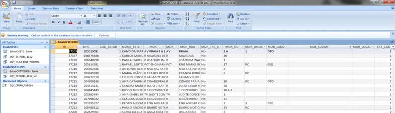
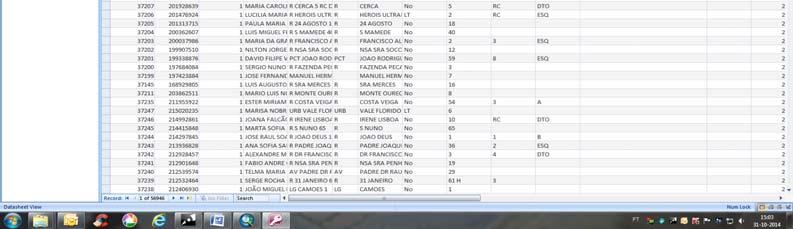
17 BR Geo processing Methodology The address is the key element to directly or indirectly match the records with the existing BGE following a step-by-step approach based on locators capable of sequentially pinpoint the BR records A different mix of those locators has been used for the cases processed MORADA_CP7 BSA_CP7_DTA BSA_CP7_ESQ MORADA_LOC_CP4 CP7 CP4 Complete address composed by type of road, name, number, 7 digit postal code Used over the BSA in order to overcome discrepancies in the address Uses the locality name and the 4 digit postal code Based on the 7 digit postal code, which is a linear structure used to code each block façade composed by the CP4 and 3 additional digits Based on the 4 digit postal code, which is a polygonal structure used to code each postal distribution area» 16
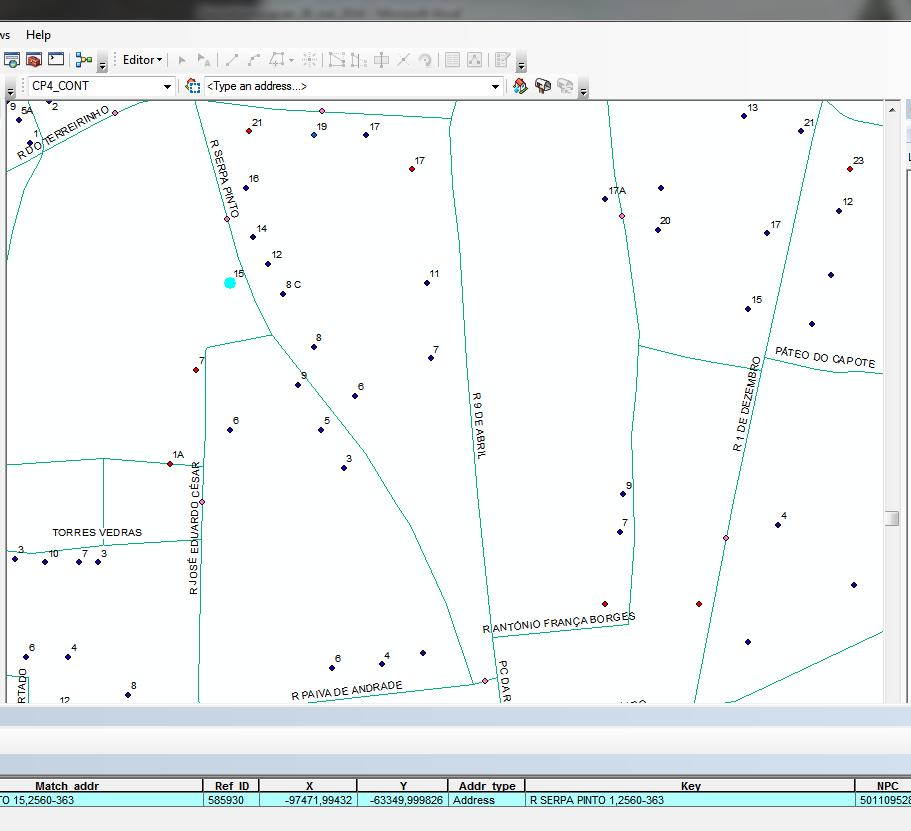
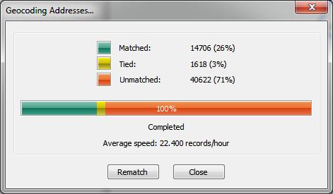
18 BR Geo processing Methodology» 17


19 Statistics Portugal Responsability: 5 themes I.3 Geographical Names I.5 Adresses III.1 Statistical Units III.2 Buildings III.10 Population Distribution demography Implementation of the INSPIRE Framework Participation in 5 Thematic WG 18
20 Implementation of the INSPIRE Framework Harmonization byhale The alignment is the mapping between source and target schemas. It defines relations between source and target entities (types or properties). Based on the defined relations a transformation is derived. Download versão ( ) versão 32 e 64 bit para windows, Mac OS, Linux» 19

21 HALE Workflow 1.Import Source/TargetSchemas Transformation according to target Schema 2.Import data 3.Defining mapping rules 4.Export transformed data 5.Data validation» 20
22 HALE Interface Schema Explorer allows you to view the structure of the source (left) and the target (right) schema in various ways and to define mappings between the elements of the schemas. Alignment view displays the current alignment per type relation and allows editing or removing mapping cells. Error Log gives you insight into the application's log messages Properties View displays information on the current selection Functions View shows the available transformation functions, which can be used to define relations. Further information on a selected function will be displayed in the Properties view. Report List provides an overview of the last completed processes 21
23 Joining BR and BGE / FNA The BR Geographic Database is joined to point based component - BGE Buildings and FNA Aiming to create a unique geocoded national framework of Statistical Units to be used in the national Statistical System» 22

24 Joining BR and BGE / FNA This data is now ready to be used by Census 2016 Pilot» 23
25 THANK YOU Data to be analysed / updated Department of Methodology and System Information GeoInformation Unit ana.msantos@ine.pt» 24
INSPIRE - A Legal framework for environmental and land administration data in Europe
 INSPIRE - A Legal framework for environmental and land administration data in Europe Dr. Markus Seifert Bavarian Administration for Surveying and Cadastre Head of the SDI Office Bavaria Delegate of Germany
Statistical-geospatial integration - The example of Sweden. Marie Haldorson Director, Statistics Sweden
 Statistical-geospatial integration - The example of Sweden Marie Haldorson Director, Statistics Sweden Spatial data and geospatial applications at Statistics Sweden Long tradition GI integrated in production
Ministry of ICT of I.R.IRAN
 The ECO 8/6 mill km 2 10 Slamic countries ~330 mill people Oil, Gas, Industries,Tourism 2 Issue transformation in last decade Problem solving needs more integrated approach More interaction &complexity
GIS Building Communities beyond National Borders (Building Successful Spatial Data Infrastructures) Nick Land, ESRI Europe
 Nick Land, ESRI Europe") GIS Building Communities beyond National Borders (Building Successful Spatial Data Infrastructures) Nick Land, ESRI Europe UK worst flooding in the last 60 years 350,000 households without drinking water
GIS Building Communities beyond National Borders (Building Successful Spatial Data Infrastructures) Nick Land, ESRI Europe UK worst flooding in the last 60 years 350,000 households without drinking water
SITMUN: Cooperating to Build Local SDIs in the Barcelona Region
 SITMUN: Cooperating to Build Local SDIs in the Barcelona Region Diputació de Barcelona Territory and Sustainability Area Territorial Information Systems Department INSPIRE CONFERENCE Barcelona, September
CES Seminar 2016: Geospatial information services based on official statistics Key issues from the session II papers
 Norbert Rainer 64 th plenary session of the Conference of European Statisticians 28 April 2016, Paris CES Seminar 2016: Geospatial information services based on official statistics Key issues from the
The state-of-the-art of the Finnish SDI. Arctic SDI WG Meeting
 The state-of-the-art of the Finnish SDI Arctic SDI WG Meeting Moscow 8.9.2011 Esa Tiainen Development Centre 1 NATIONAL LAND SURVEY DOWN TO EARTH Contents Legal framework Coordination structure Network
ESDIN Results from a Crossborder INSPIRE Preparatory Project. Jörgen Hartnor, Lantmäteriet.
 ESDIN Results from a Crossborder INSPIRE Preparatory Project Jörgen Hartnor, Lantmäteriet www.esdin.eu Ett econtentplus Best Practice Network projekt September 2008 February 2011 Coordinated by EuroGeographics
Principle 3: Common geographies for dissemination of statistics Poland & Canada. Janusz Dygaszewicz Statistics Poland
 Principle 3: Common geographies for dissemination of statistics Poland & Canada Janusz Dygaszewicz Statistics Poland Reference materials Primary: Ortophotomap, Cadastral Data, Administrative division borders,
The File Geodatabase API. Craig Gillgrass Lance Shipman
 The File Geodatabase API Craig Gillgrass Lance Shipman Schedule Cell phones and pagers Please complete the session survey we take your feedback very seriously! Overview File Geodatabase API - Introduction
INSPIREd solutions for Air Quality problems Alexander Kotsev
 INSPIREd solutions for Air Quality problems Alexander Kotsev www.jrc.ec.europa.eu Serving society Stimulating innovation Supporting legislation The European data puzzle The European data puzzle 24 official
Swedish examples on , and
 Swedish examples on 11.2.1, 11.3.1 and 11.7.1 Marie Haldorson, Director Seminar in Nairobi 7 Dec 2018 SDG Indicator Tests by Countries in Europe GEOSTAT 3: ESS Project with a purpose to guide countries
Implementation of Inspire in Denmark - How we get it flying! Olav Eggers National Survey & Cadastre -Denmark
 Implementation of Inspire in Denmark - How we get it flying! Olav Eggers oe@kms.dk National Survey & Cadastre -Denmark Introduction Overview Infrastructure for Spatial Information Act National Survey and
SDI Development in Georgia. Mari Khardziani Head of International Relations Unit National Agency of Public Registry
 SDI Development in Georgia Mari Khardziani Head of International Relations Unit National Agency of Public Registry Kehl, Germany September 5, 2017 2 National Agency of Public Registry Legal Entity of Public
The European Forum for Geospatial Statistics Benefits and challenges of INSPIRE in the field of statistics
 INSPIRE Conference 2016 Barcelona, Spain 26th 30th September 2016 The European Forum for Geospatial Statistics Benefits and challenges of INSPIRE in the field of statistics Janusz Dygaszewicz EFGS President
GIS FOR MAZOWSZE REGION - GENERAL OUTLINE
 GIS FOR MAZOWSZE REGION - GENERAL OUTLINE S. Bialousz 1), K Mączewski 2), E. Janczar 2), K. Osinska-Skotak 1) 1) Warsaw University of Technology, Warsaw, Poland 2) Office of the Surveyor of the Mazowieckie
Common geographies for dissemination of SDG Indicators
 5 th High Level Forum on United Nations GGIM, Mexico 2017 Common geographies for dissemination of SDG Indicators Understanding statistical and geodetic division of territory Janusz Dygaszewicz Central
Spatial Data Infrastructure Concepts and Components. Douglas Nebert U.S. Federal Geographic Data Committee Secretariat
 Spatial Data Infrastructure Concepts and Components Douglas Nebert U.S. Federal Geographic Data Committee Secretariat August 2009 What is a Spatial Data Infrastructure (SDI)? The SDI provides a basis for
Bentley Map Advancing GIS for the World s Infrastructure
 Bentley Map Advancing GIS for the World s Infrastructure Presentation Overview Why would you need Bentley Map? What is Bentley Map? Where is Bentley Map Used? Why would you need Bentley Map? Because your
INSPIRE Basics. Vlado Cetl European Commission Joint Research Centre. https://ec.europa.eu/jrc/
 INSPIRE Basics Vlado Cetl European Commission Joint Research Centre https://ec.europa.eu/jrc/ Serving society Stimulating innovation Supporting legislation Outline SDI? Why European SDI? INSPIRE Policy
Status of implementation of the INSPIRE Directive 2016 Country Fiches. COUNTRY FICHE Netherlands
 Status of implementation of the INSPIRE Directive 2016 Country Fiches COUNTRY FICHE Netherlands Introduction... 1 1. State of Play... 2 1.1 Coordination... 2 1.2 Functioning and coordination of the infrastructure...
ESBN. Working Group on INSPIRE
 ESBN Working Group on INSPIRE by Marc Van Liedekerke, Endre Dobos and Paul Smits behalf of the WG members WG participants Marc Van Liedekerke Panos Panagos Borut Vrščaj Ivana Kovacikova Erik Obersteiner
Emerging Trends in Institutional Arrangements Europe - Finland
 Emerging Trends in Institutional Arrangements Europe - Finland Arvo Kokkonen Deputy Director General National Land Survey of Finland 1 Contents Facts about Finland National Land Survey of Finland European
Governance and performance of open spatial data policies in the context of INSPIRE
 Governance and performance of open spatial data policies in the context of INSPIRE Dr. Glenn Vancauwenberghe Delft University of Technology Dr. ir. Bastiaan van Loenen Delft University of Technology 1
Land Board, NW Services and SDI Tambet Tiits, FRICS
 Land Board, NW Services and SDI Tambet Tiits, FRICS 07.09.2016 200th anniversary of the Struve Geodetic Arc Friedrich Georg Wilhelm Struve and Carl Friedrich Tenner Struve Geodetic Arc The Struve Geodetic
EuroGeographics & INSPIRE. Nick Land, Executive Director of EuroGeographics
 EuroGeographics & INSPIRE Nick Land, Executive Director of EuroGeographics EuroGeographics A growing association 49 Members, 42 countries Topographic mapping, cadastre, land registry + Networked organisation
Spatial data interoperability and INSPIRE compliance the platform approach BAGIS
 Spatial data interoperability and INSPIRE compliance the platform approach BAGIS BAGIS Voluntary, independent, public, non-profit organization; Organization with main mission to promote the growth of the
Establishing the National Spatial Data Infrastructure (NSDI) for Norway a joint effort by many stakeholders SPATIAL DATA FOR BENEFIT OF THE SOCIETY
 for Norway a joint effort by many stakeholders SPATIAL DATA FOR BENEFIT OF THE SOCIETY") Establishing the National Spatial Data Infrastructure (NSDI) for Norway a joint effort by many stakeholders SPATIAL DATA FOR THE BENEFIT OF SOCIETY OUTLINE Political background Norway digital - The Norwegian
Establishing the National Spatial Data Infrastructure (NSDI) for Norway a joint effort by many stakeholders SPATIAL DATA FOR THE BENEFIT OF SOCIETY OUTLINE Political background Norway digital - The Norwegian
The World Bank and the Open Geospatial Web. Chris Holmes
 The World Bank and the Open Geospatial Web Chris Holmes Geospatial is Everywhere QuickTime and a TIFF (Uncompressed) decompressor are needed to see this picture. Spatial Data Infrastructure (SDI) the sources,
Compact guides GISCO. Geographic information system of the Commission
 Compact guides GISCO Geographic information system of the Commission What is GISCO? GISCO, the Geographic Information System of the COmmission, is a permanent service of Eurostat that fulfils the requirements
Between legislation and consensus how do we INSPIRE Denmark?
 Between legislation and consensus how do we INSPIRE Denmark? Olav Eggers Spatial Data Infrastructure Division Danish Ministry of the Environment National Survey and Cadastre (KMS), Denmark INSPIRE Contact
The Global Statistical Geospatial Framework and the Global Fundamental Geospatial Themes
 The Global Statistical Geospatial Framework and the Global Fundamental Geospatial Themes Sub-regional workshop on integration of administrative data, big data and geospatial information for the compilation
Big-Geo-Data EHR Infrastructure Development for On-Demand Analytics
 Big-Geo-Data EHR Infrastructure Development for On-Demand Analytics Sohayla Pruitt, MA Senior Geospatial Scientist Duke Medicine DUHS DHTS EIM HIRS Page 1 Institute of Medicine, World Health Organization,
Technical Framework Methodology as a core of building up the NSDI NSDI Implementation Specifics in Serbia
 Technical Framework Methodology as a core of building up the NSDI NSDI Implementation Specifics in Serbia Luka Jovičić SDI Consultant@ Gramont Ltd. Aleksandar Dedić RGA NSDI department Dragica Pajić RGA
The Integrated Ge spatial Information Framework to the strengthening of NSDI, Mongolia
 Young Geospatial Professionals Summit 21 NOV 2018 The Integrated Ge spatial Information Framework to the strengthening of NSDI, Mongolia BAYARMAA ENKHTUR Geospatial information and technology department
Status of implementation of the INSPIRE Directive 2016 Country Fiches. COUNTRY FICHE Portugal
 Status of implementation of the INSPIRE Directive 2016 Country Fiches COUNTRY FICHE Portugal Introduction... 1 1. State of Play... 2 1.1 Coordination... 2 1.2 Functioning and coordination of the infrastructure...
Innovation. The Push and Pull at ESRI. September Kevin Daugherty Cadastral/Land Records Industry Solutions Manager
 Innovation The Push and Pull at ESRI September 2004 Kevin Daugherty Cadastral/Land Records Industry Solutions Manager The Push and The Pull The Push is the information technology that drives research and
QUALITY CONTROL ROLE IN PROCESS OF ESTABLISHMENT OF NSDI
 QUALITY CONTROL ROLE IN PROCESS OF ESTABLISHMENT OF NSDI S. Lemajić a,lj. Rašić b a Croatian Geodetic Institute, Savska 41/XVI, Zagreb, Croatia slavko.lemajic@cgi.hr b State Geodetic Administration, Lastovska
Turkey s National SDI Implementation
 Onur PAŞAOĞULLARI Head of Department Turkey s National SDI Implementation Presentation Plan NSDI Background General Directorate of Geographic Information Systems NSDI Project INSPIRE Directive Urban Information
Influence of INSPIRE on European/national data specifications
 www.eurogeographics.org Influence of INSPIRE on European/national data specifications Saulius Urbanas, EuroGeographics 20 th June 2017 Copyright 2013 EuroGeographics EuroGeographics 46 European countries
TheEuropean Location Framework
 TheEuropean Location Framework Presentation to: Author: Date: TN-ITS/INSPIRE session at INSPIRE Conference Olaf Magnus Østensen, ELF co-ordinator 18 June2014 The ELF project 15 national mapping authorities
Government GIS and its Application for Decision Support
 Government GIS and its Application for Decision Support Zhang Qingpu (Chinese Academy of Surveying and Mapping, Email: zhangqp@casm.ac.cn) Abstract: Application of GIS in government agencies is called
CENSUS MAPPING WITH GIS IN NAMIBIA. BY Mrs. Ottilie Mwazi Central Bureau of Statistics Tel: October 2007
 CENSUS MAPPING WITH GIS IN NAMIBIA BY Mrs. Ottilie Mwazi Central Bureau of Statistics E-mail: omwazi@npc.gov.na Tel: + 264 61 283 4060 October 2007 Content of Presentation HISTORICAL BACKGROUND OF CENSUS
Roadmap to interoperability of geoinformation
 Roadmap to interoperability of geoinformation and services in Europe Paul Smits, Alessandro Annoni European Commission Joint Research Centre Institute for Environment and Sustainability paul.smits@jrc.it
Estonian approach to implementation of INSPIRE directive. Sulev Õitspuu Head of Bureau of Geoinfosystems Estonian Land Board
 Estonian approach to implementation of INSPIRE directive Sulev Õitspuu Head of Bureau of Geoinfosystems Estonian Land Board 13.06.2016 Contents - INSPIRE coordination in Estonia - INSPIRE implementation
Technical Specifications. Form of the standard
 Used by popular acceptance Voluntary Implementation Mandatory Legally enforced Technical Specifications Conventions Guidelines Form of the standard Restrictive Information System Structures Contents Values
Global Geospatial Information Management Country Report Finland. Submitted by Director General Jarmo Ratia, National Land Survey
 Global Geospatial Information Management Country Report Finland Submitted by Director General Jarmo Ratia, National Land Survey Global Geospatial Information Management Country Report Finland Background
Geospatial SDI Portal for effective Governance of Pune METROPOLIS region
 Geospatial SDI Portal for effective Governance of Pune METROPOLIS region Mr. Praveen Gautam Senior Manager 19 th January 2018 PMRDA Overview Provide a Spatial Framework for the entire region with various
Work Group A «Core Data» Report and Update François Chirié, Dominique Laurent, France
 JOINT UN-GGIM: EUROPE ESS MEETING ON THE INTEGRATION OF STATISTICAL AND GEOSPATIAL INFORMATION LUXEMBOURG 11 MARCH 2016 Work Group A «Core Data» Report and Update François Chirié, Dominique Laurent, France
The 2020 Census Geographic Partnership Opportunities
 The 2020 Census Geographic Partnership Opportunities Web Adams Geographer, U.S. Census Bureau New York Regional Office 1 Geographic Partnership Opportunities The 2020 Census Local Update of Census Addresses
Rules of the territorial division
 Rules of the territorial division Janusz Dygaszewicz Central Statistical Office of Poland Jerusalem, 4-7 December 2016 Rules of territory division (the Polish case) The area of each unit of territorial
INSPIRing Geospatial Framework For Local Administrations
 This project is financed by the European Union and the Republic of Turkey Presented at the FIG Congress 2018, May 6-11, 2018 in Istanbul, Turkey National Programme for Turkey 2010 Instrument for Pre-Accession
SDI Implementation at the Local
 SDI Implementation at the Local Administration Level of Germany Hartmut Müller and Stephan von St. Vith FIG Working Week 2009 Surveyors Key Role in Accelerated Development, Eilat, Israel, 3-8 May 2009
Lesson 16: Technology Trends and Research
 http://www.esri.com/library/whitepapers/pdfs/integrated-geoenabled-soa.pdf GEOG DL582 : GIS Data Management Lesson 16: Technology Trends and Research Overview Learning Objective Questions: 1. Why is integration
Office of Technology Partnerships GIS Collaboration
 Office of Technology Partnerships GIS Collaboration State GIS Update April 21, 2017 Mark Holmes, GISP Outline MGF Upgrade Project Census Programs Imagery Update LiDAR Update Open Discussion 2 MGF Background
INSPIRE Shared Service
 INSPIRE Shared Service Creation and operation out of the box Petra Fritz (HZD), Michael Voigtländer (Esri Deutschland GmbH) INSPIRE Shared Service Agenda HZD backbone for a geodata infrastructure Implementing
for Effective Land Administration
 Role of Geospatial Technology in Land Information System(LIS) for Effective Land Administration Dr. Deb Jyoti Pal Sections Role of GIS in Land Records Proposed Work Flow Case Studies Role of GIS Creating
Steve Pietersen Office Telephone No
 Steve Pietersen Steve.Pieterson@durban.gov.za Office Telephone No. 031 311 8655 Overview Why geography matters The power of GIS EWS GIS water stats EWS GIS sanitation stats How to build a GIS system EWS
MedIsolae-3D. Mediterranean Islands SDI and 3D Aerial Web Navigation. Giacomo Martirano. (Epsilon Italia)
") MedIsolae-3D Mediterranean Islands SDI and 3D Aerial Web Navigation Giacomo Martirano (Epsilon Italia) GSDI 11 WORLD CONFERENCE 15-19 June, Rotterdam, The Netherlands Presentation Overview SDIs for the
MedIsolae-3D Mediterranean Islands SDI and 3D Aerial Web Navigation Giacomo Martirano (Epsilon Italia) GSDI 11 WORLD CONFERENCE 15-19 June, Rotterdam, The Netherlands Presentation Overview SDIs for the
INSPIRATION RESULTS AND BENEFITS ALBANIA
 INSPIRATION RESULTS AND BENEFITS ALBANIA By Eng. Besnik Çomo Paper prepared for E&I Workshop: Support to INSPIRE Implementation in enlargement and EWP Countries JRC ISPRA Central Office of Immovable Property
1 ST High Level Forum on United Nations Global Geoespatial Information Management GEOGRAPHIC REFERENCING OF ECONOMIC UNITS. México
 1 ST High Level Forum on United Nations Global Geoespatial Information Management Thematic Seminar 27 October, Korea 2011. GEOGRAPHIC REFERENCING OF ECONOMIC UNITS México CONTENTS Introduction Census Cartography
Proposal for a DIRECTIVE OF THE EUROPEAN PARLIAMENT AND OF THE COUNCIL. establishing an infrastructure for spatial information in the Community
 Proposal for a DIRECTIVE OF THE EUROPEAN PARLIAMENT AND OF THE COUNCIL establishing an infrastructure for spatial information in the Community INSPIRE http://inspire.jrc.it/ Alessandro Annoni 1 EU Commission
Are You Maximizing The Value Of All Your Data?
 Are You Maximizing The Value Of All Your Data? Using The SAS Bridge for ESRI With ArcGIS Business Analyst In A Retail Market Analysis SAS and ESRI: Bringing GIS Mapping and SAS Data Together Presented
Pal NIKOLLI Bashkim IDRIZI Ismail KABASHI Adelajda HALILI THE IMPLEMENTATION OF NATIONAL SPATIAL DATA INFRASTRUCTURE IN ALBANIA
 Pal NIKOLLI Bashkim IDRIZI Ismail KABASHI Adelajda HALILI THE IMPLEMENTATION OF NATIONAL SPATIAL DATA INFRASTRUCTURE IN ALBANIA Overview: Goals of paper Some definitions of SDI NSDI Development NSDI in
NAG-City Expert Workshop Oslo 8-9. October 2012 SOSI standards and mapping for Europe (INSPIRE)
") NAG-City Expert Workshop Oslo 8-9. October 2012 SOSI standards and mapping for Europe (INSPIRE) Per Ryghaug, Geomatics The Norwegian national standard on geographic information - SOSI Started in 1984 NGU
NAG-City Expert Workshop Oslo 8-9. October 2012 SOSI standards and mapping for Europe (INSPIRE) Per Ryghaug, Geomatics The Norwegian national standard on geographic information - SOSI Started in 1984 NGU
Status of implementation of the INSPIRE Directive 2016 Country Fiches. COUNTRY FICHE Czech Republic
 Status of implementation of the INSPIRE Directive 2016 Country Fiches COUNTRY FICHE Czech Republic Introduction... 1 1. State of Play... 2 1.1 Coordination... 2 1.2 Functioning and coordination of the
GROUP ON INTEGRATION OF STATISTICAL AND GEOSPATIAL INFORMATION GT-IIEG
 UN-GGIM: Americas WORKING GROUP ON INTEGRATION OF STATISTICAL AND GEOSPATIAL INFORMATION GT-IIEG Bogotá, Colombia August, 2018 www.dane.gov.co Working group GT-IIEG Objective: To raise awareness and promote
Qatar Statistical Geospatial Integration
 Qatar Statistical Geospatial Integration A Presentation by the Ministry of Development Planning & Statistics (MDPS), State of Qatar http://www.mdps.gov.qa (Fourth UN-GGIM Arab States Committee Meeting,
The Process of Spatial Data Harmonization in Italy. Geom. Paola Ronzino
 The Process of Spatial Data Harmonization in Italy Geom. Paola Ronzino ISSUES Geospatial Information in Europe: lack of data harmonization the lack of data duplication of data CHALLENGES Challenge of INSPIRE:
Data harmonization aspects of the Irish pilot project for INSPIRE data publishing and Network Services
 Data harmonization aspects of the Irish pilot project for INSPIRE data publishing and Network Services Gareth John (Department of Environment, Community and Local Government) Sören Dupke (con terra) INSPIRE
GIS ADMINISTRATOR / WEB DEVELOPER EVANSVILLE-VANDERBURGH COUNTY AREA PLAN COMMISSION
 GIS ADMINISTRATOR / WEB DEVELOPER EVANSVILLE-VANDERBURGH COUNTY AREA PLAN COMMISSION SALARY RANGE INITIATION $43,277 SIX MONTHS $45,367 POSITION GRADE PAT VI The Evansville-Vanderburgh County Area Plan
Spatially enabling e-government through geo-services
 Spatially enabling e-government through geo-services Mauro Salvemini EUROGI PRESIDENT Professor at Sapienza Università di Roma (IT) 1 About the presentation Few information about Eurogi ; Some essential
ISO Series Standards in a Model Driven Architecture for Landmanagement. Jürgen Ebbinghaus, AED-SICAD
 ISO 19100 Series Standards in a Model Driven Architecture for Landmanagement Jürgen Ebbinghaus, AED-SICAD 29.10.2003 The Company 100% SIEMENS PTD SIEMENS Business Services Shareholder & Strategic Business
Geodatabase Management Pathway
 Geodatabase Management Pathway Table of Contents ArcGIS Desktop II: Tools and Functionality 3 ArcGIS Desktop III: GIS Workflows and Analysis 6 Building Geodatabases 8 Data Management in the Multiuser Geodatabase
CHILEAN GEO-SPATIAL NATIONAL DATA INFRASTRUCTURE (INDE) Pablo Gran Rodrigo Barriga Alfredo Gonzalez María L. Advis Juan C. Montero Leonardo Oyarzun
 Pablo Gran Rodrigo Barriga Alfredo Gonzalez María L. Advis Juan C. Montero Leonardo Oyarzun") CHILEAN GEO-SPATIAL NATIONAL INFRASTRUCTURE (INDE) Pablo Gran Rodrigo Barriga Alfredo Gonzalez María L. Advis Juan C. Montero Leonardo Oyarzun ABSTRACT The present paper summarizes a joint effort undertaken
CHILEAN GEO-SPATIAL NATIONAL INFRASTRUCTURE (INDE) Pablo Gran Rodrigo Barriga Alfredo Gonzalez María L. Advis Juan C. Montero Leonardo Oyarzun ABSTRACT The present paper summarizes a joint effort undertaken
BROADBAND DEMAND AGGREGATION: PLANNING BROADBAND IN RURAL NORTHERN CALIFORNIA
 BROADBAND DEMAND AGGREGATION: PLANNING BROADBAND IN RURAL NORTHERN CALIFORNIA Steven J. Steinberg, Ph.D a,b, *, Rebecca Degagne a, M.S., Michael Gough a a Institute for Spatial Analysis, Humboldt State
Mitsuhiko Kawakami and Zhenjiang Shen Department of Civil Engineering Faculty of Engineering Kanazawa University Japan ABSTRACT
 ABSTRACT Formulation of an Urban and Regional Planning System Based on a Geographical Information System and its Application - A Case Study of the Ishikawa Prefecture Area of Japan - Mitsuhiko Kawakami
I Background. Under the Cotton Tree: Situs Addressing System in Africa. Table of contents
 Cairo, April 2005 Under the Cotton Tree: Situs Addressing System in Africa Table of contents 1. Background 2. Current situation of addressing system in Africa 3. Benefits of a functional addressing system
Application of GIS in Public Transportation Case-study: Almada, Portugal
 Case-study: Almada, Portugal Doutor Jorge Ferreira 1 FSCH/UNL Av Berna 26 C 1069-061 Lisboa, Portugal +351 21 7908300 jr.ferreira@fcsh.unl.pt 2 FSCH/UNL Dra. FCSH/UNL +351 914693843, leite.ines@gmail.com
Geographical Collections in Greek Academic Libraries: current situation and perspectives
 Ionian University Department of Archives and Library Science Laboratory on Digital Libraries and Electronic Publishing Geographical Collections in Greek Academic Libraries: current situation and perspectives
INSPIRE implementation in Portugal: the operational approach
 INSPIRE implementation in Portugal: the operational approach REIS, Rui; SANTOS, Ana Sofia; FONSECA, Alexandra; SILVA, Henrique; GOMES, Ana Luisa; FURTADO, Danilo; GEIRINHAS, João rui.reis@igeo.pt AGENDA
Ready for INSPIRE.... connecting worlds. European SDI Service Center
 Ready for INSPIRE Consultancy SOFTWARE T r a i n i n g Solutions... connecting worlds European SDI Service Center Increasing Added Value with INSPIRE and SDI Components INSPIRE In 2007, the European Commission
UNIT 4: USING ArcGIS. Instructor: Emmanuel K. Appiah-Adjei (PhD) Department of Geological Engineering KNUST, Kumasi
 Department of Geological Engineering KNUST, Kumasi") UNIT 4: USING ArcGIS Instructor: Emmanuel K. Appiah-Adjei (PhD) Department of Geological Engineering KNUST, Kumasi Getting to Know ArcGIS ArcGIS is an integrated collection of GIS software products ArcGIS
UNIT 4: USING ArcGIS Instructor: Emmanuel K. Appiah-Adjei (PhD) Department of Geological Engineering KNUST, Kumasi Getting to Know ArcGIS ArcGIS is an integrated collection of GIS software products ArcGIS
The ecadastre System. Francis KAELL ecadastre project manager
 The ecadastre System Francis KAELL ecadastre project manager ecadastre what s that? A mapping tool to view, combine and analyze geodata in a browser A product catalogue which describes all the available
Paloma Abad LÓPEZ, Emilio; SÁNCHEZ, Alejandra; RODRÍGUEZ, Antonio F; SOTERES, Carolina. September 17
 Paloma Abad LÓPEZ, Emilio; SÁNCHEZ, Alejandra; RODRÍGUEZ, Antonio F; SOTERES, Carolina 1 We know Directive 2007/2/EC requires Member States to monitor the implementation and use of their infrastructures
Status of implementation of the INSPIRE Directive 2016 Country Fiches. COUNTRY FICHE France
 Status of implementation of the INSPIRE Directive 2016 Country Fiches COUNTRY FICHE France Introduction... 1 1. State of Play... 2 1.1 Coordination... 2 1.2 Functioning and coordination of the infrastructure...
The Infrastructure for Spatial Information in the European Community vs. regional SDI: the shortest way for reaching economic and social development
 The Infrastructure for Spatial Information in the European Community vs. regional SDI: the shortest way for reaching economic and social development Mauro Salvemini EUROGI PRESIDENT Professor at Sapienza
Institute of Statistical and Geographical Information of Jalisco State Subnational Statistical and Geographical System India.
 Institute of Statistical and Geographical Information of Jalisco State Subnational Statistical and Geographical System India. January 2017 Subnational Statistical and Geographical System National Statistical
Grant Agreement No. EIE/07/595/SI BEn
 Biomass energy register for sustainable site development for European regions Grant Agreement No. EIE/07/595/SI2.499697 BEn Biomass energy register for sustainable site development for European regions
Imagery and the Location-enabled Platform in State and Local Government
 Imagery and the Location-enabled Platform in State and Local Government Fred Limp, Director, CAST Jim Farley, Vice President, Leica Geosystems Oracle Spatial Users Group Denver, March 10, 2005 TM TM Discussion
Digital Map of Mexico Platform and MxSIG. March 2017
 Digital Map of Mexico Platform and MxSIG March 2017 1 I. Digital Map of Mexico Platform Concept Evolution II. Digital Map of Mexico online Concept Capabilities Information available Other state units information
Report on the impact of open geographical data - Danish effect studies -
 Presented at the FIG Congress 2018, May 6-11, 2018 in Istanbul, Turkey Report on the impact of open geographical data - Danish effect studies - (Paper no 9603) Agenda 1. Intro teaser 2. Basic digital infrastructure
Overview of Geospatial Open Source Software which is Robust, Feature Rich and Standards Compliant
 Overview of Geospatial Open Source Software which is Robust, Feature Rich and Standards Compliant Cameron SHORTER, Australia Key words: Open Source Geospatial Foundation, OSGeo, Open Standards, Open Geospatial
Spatially Enabled Society
 International Seminar on Land Administration Trends and Issues in Asia and the Pacific Region Spatially Enabled Society Abbas Rajabifard Vice Chair PCGIAP-WG3 Vice-President (President Elect), GSDI Association
ArcGIS Platform For NSOs
 ArcGIS Platform For NSOs Applying GIS and Spatial Thinking to Official Statistics Esri UC 2014 Demo Theater Applying GIS at the NSO Generic Statistical Business Process Model (GSBPM) 1 Specify Needs 2
Voices from Private Sector: Insights for Future NSDI Development in Indonesia
 Voices from Private Sector: Insights for Future NSDI Development in Indonesia Ta n d a n g Yu l i a d i D w i P u t ra, Ryosuke S h i b a s a k i I n st i t u t e o f I n d u st r i a l S c i e n c e,
NATIONAL BENEFITS OF INSPIRE IMPLEMENTATION THE REAL LIFE USE CASES
 NATIONAL BENEFITS OF INSPIRE IMPLEMENTATION THE REAL LIFE USE CASES Andrius Balciunas, SE GIS Centras, a.balciunas@gis centras.lt Evaldas Rozanskas, SE GIS Centras, e.rozanskas@gis centras.lt INSPIRE conference
GIS Capability Maturity Assessment: How is Your Organization Doing?
 GIS Capability Maturity Assessment: How is Your Organization Doing? Presented by: Bill Johnstone Principal Consultant Spatial Vision Group November 8, 2018 1. Motivation for Capability Maturity Models
Egypt Public DSS. the right of access to information. Mohamed Ramadan, Ph.D. [R&D Advisor to the president of CAPMAS]
![Egypt Public DSS. the right of access to information. Mohamed Ramadan, Ph.D. [R&D Advisor to the president of CAPMAS]](/thumbs/89/98483713.jpg "Egypt Public DSS. the right of access to information. Mohamed Ramadan, Ph.D. [R&D Advisor to the president of CAPMAS]") Egypt Public DSS ì the right of access to information Central Agency for Public Mobilization and Statistics Arab Republic of Egypt Mohamed Ramadan, Ph.D. [R&D Advisor to the president of CAPMAS] Egypt
Egypt Public DSS ì the right of access to information Central Agency for Public Mobilization and Statistics Arab Republic of Egypt Mohamed Ramadan, Ph.D. [R&D Advisor to the president of CAPMAS] Egypt
a national geological survey perspective François ROBIDA BRGM (French Geological Survey)
") a national geological survey perspective François ROBIDA BRGM (French Geological Survey) Pre-Conference Seminar on Socio-Economic Value of Geospatial for National and Regional Development 21 August 2017,
a national geological survey perspective François ROBIDA BRGM (French Geological Survey) Pre-Conference Seminar on Socio-Economic Value of Geospatial for National and Regional Development 21 August 2017,