Environmental Liabilities Reconciliation & Mapping Pilot Project
|
|
|
- James Hamilton
- 5 years ago
- Views:
Transcription
, Business Enterprise Integration 23 May,")
1 Environmental Liabilities Reconciliation & Mapping Pilot Project David LaBranche, P.E. DISDI Mission Assurance Officer ODUSD(I&E), Business Enterprise Integration 23 May, 2007
2 EL Mapping & Reconciliation Pilot Summary of Scope Non-DERP Sites Objective: Develop a department-wide Environmental Liabilities reconciliation process and standards to enable the Components to demonstrate completeness of the EL site records at each installation. DERP Sites RPI Site & Parcels ENVIRONMENTAL LIABILITIES Approach: The pilot will establish and test the technical approach and work flow for the acquisition of EL geospatial data and reconciliation of EL sites to one or more real property assets (RPA), i.e. land parcels
3 EL Mapping & Reconciliation Pilot Summary of Scope (Cont.) Deliverables: One EL Site Geodatabase per Installation Existing DERP and non-derp Environmental Site Spatial Data will be Used, with Minor Augmentation Each EL Site will be Assigned a Temporary UID Manual on Mapping and Maintaining EL Geospatial Data Which Includes: To Be Process Model for Mapping and Maintaining EL Geospatial Data and Reconciling with Real Property Asset Records Quality Assurance Plan Recommendations for Sustainable Component Implementation
4 Environmental Liabilities Mapping Pilot Sites 1. MCB & MCAS Pendleton 2. Naval Air Weapons Center China Lake 8. Point Mugu (sub-installation to Navy Base Ventura County) 9. Eglin AFB 3. Edwards AFB 4. Vandenberg AFB 5. Aberdeen Proving Ground (and Edgewood Arsenal) 6. White Sands Missile Range 7. Joint Reserve Base New Orleans *Highlighted sites are first Joint Base McGuire (USAF lead) 10. McGuire AFB 11. FT Dix 12. NAES Lakehurst Joint Base Andrews (USAF lead) 13. Andrews AFB 14. Naval Air Facility Washington
5 EL Mapping & Reconciliation Pilot - Status 14 Installations Scoped; Two Contractors (Woolpert and Towill) Contract Effort Initiated Following Government Notification of EL Staff and Installation Staff RPI Mapping Working Group Meetings, Dec 06 ADUSD(ESOH) Signed Notification Request Memo 28 Dec Feb 07: Kickoff Meeting, EL Reconciliation Pilot Working Group Government pre-meeting focused on developing common understanding of the Scope of Work Each Service shared issues, concerns Contractors met previously with Army and Navy EL staff, visited Edwards AFB and Vandenberg AFB All EL spatial mapping will conform to DoD geospatial data standards Only 2-dimensional data will be used or collected Only EL associated with land assets will be mapped and reconciled
6 EL Mapping & Reconciliation Pilot Status (cont) ODUSD(I&E) Issued Clarification to SOW: Reconciliation will be carried out to Facility (Asset) level if spatial data exists (Building or Facility numbers are considered spatial data for this project) EL Spatial Data Model Must align with BEA 4.0 Current SDSFIE entities and taxonomy will be documented in order to facilitate future data migration to SDSFIE 3.0 Will contain only simple spatial geometry layers (point, line, polygon) linked to EL business databases for attribution EL Hazard Categories Contractor provided an Environmental Site Type Example List by OSD Draft Process Flow for Reconciliation of EL to RPA BEI providing a high level process diagram to serve as a starting point for contractors to implement, test and recommend changes to
7 Pilot Spatial Data Model for EL Intersect => populate RPAUID EL_polygon link RPA GeoData Geospatial database(s) Storing real property data From RPI Mapping Project Intersect EL_line link EL Master List Created By Contractor from existing environmental databases EL_point link Geometry storage containers

8 Example EL Spatial Data

9 Example EL Spatial Data Table
10 Environmental Liabilities Database Chaos Existing Environmental Databases Wide Variety Disparate Systems and Formats to Serve Disparate Missions Common Thread is EL Category RPA Geospatial Data Spatial Join Gross Reconciliation EL_Point EL_Polygon EL_Line [Composite] [Composite] (View) [Composite] BGGENEXS Services Will Need to Resolve Pilot Project Focuses on Process, not Data or System Architectures MLSFTAMO IRP Composite EHTNKAST HW Accum Area EHSITAOC EHSITIRP EHGENEXL Air Emission Pt

11 Draft Process Flow

![[Andrews Pilot 2006] New Level of Data](/docs-images/83/87291274/images/12-3.jpg "Granularity Attributes per RPIR Guidance")
12 Real Property Mapping - Work Product Installation_Area [CIP 2007] RPI_Parcels [Andrews Pilot 2006] New Level of Data Granularity Attributes per RPIR Guidance Interactions w/ppe Spectrum
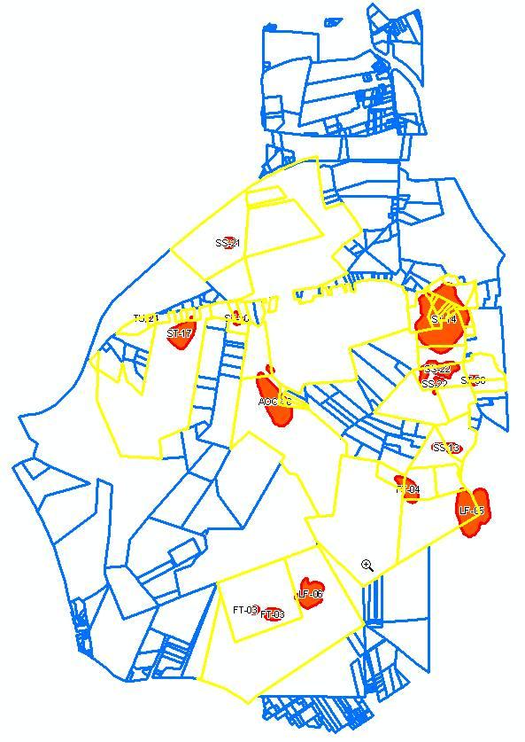
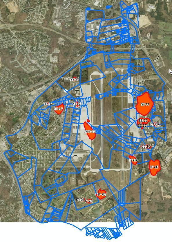
13 EHSITIRP Reconciled with Land Parcels

14 Areas of Potential Environmental Concern
15 Benefits of RPI Geospatial Mapping Automated Reconciliation of Environmental Liabilities DERP Sites vs Parcels Example: Andrews AFB Env. Concern Sites vs Parcels 44 of 253 Parcels have EL (DERP) 137 of 253 Parcels have potential EL


16 Questions? Mr. David LaBranche, P.E. Defense Installation Spatial Data Infrastructure (DISDI) Office of the Deputy Undersecretary of Defense for Installations & Environment, Business Enterprise Integration Directorate DUSD/I&E(BEI) Web site and DISDI Portal:
Army Installation Geospatial Information and Services (IGI&S) Program Overview
 Program Overview") Army Installation Geospatial Information and Services (IGI&S) Program Overview Joshua Delmonico Geospatial Information Officer OACSIM IGI&S Program 703-602-2851 Joshua.Delmonico@hqda.army.mil 1of 11 221400
Army Installation Geospatial Information and Services (IGI&S) Program Overview Joshua Delmonico Geospatial Information Officer OACSIM IGI&S Program 703-602-2851 Joshua.Delmonico@hqda.army.mil 1of 11 221400
Instituting Land Use Controls (LUCs) for Environmental Compliance and Planning
 for Environmental Compliance and Planning") Eleventh Air Force Instituting Land Use Controls (LUCs) for Environmental Compliance and Planning Robert Beachler GeoBase Administrator 611 Civil Engineer Squadron Elmendorf AFB, AK As of: 1 Agenda Introduction
Eleventh Air Force Instituting Land Use Controls (LUCs) for Environmental Compliance and Planning Robert Beachler GeoBase Administrator 611 Civil Engineer Squadron Elmendorf AFB, AK As of: 1 Agenda Introduction
ARMY ITAM GIS: Automating Standard Army Training Map Production
 ARMY ITAM GIS: Automating Standard Army Training Map Production Douglas Willets ITAM Western Regional Support Center, Center for Environmental Management of Military Lands, Colorado State University, Fort
Enterprise, Environmental, Safety, Occupational Health- Management Information System
 Headquarters U.S. Air Force I n t e g r i t y - S e r v i c e - E x c e l l e n c e Enterprise, Environmental, Safety, Occupational Health- Management Information System Nadine Gawlak HQ AFCESA/CEOI 1
Geo-enable the Business Enterprise Architecture
 Geo-enable the Business Enterprise Architecture Geographic Approach for Enterprise Architecture Costi Tudan CH2M HILL DISDI Architect ODUSD I&E BEI Defense Basing Space - The DoD Footprint Major Elements
Government Furnished Property Process Implementation Training
 Government Furnished Property Process Implementation Training Presented by: Carol Vigna, OSD AT&L DPAP carol.a.vigna.civ@mail.mil Pam Rooney, Support to OSD AT&L DPAP www.dodprocurementtoolbox.com Defense
To: Ross Martin, Lisa Stapleton From: Brad Lind Subject: Joint Funding Agreement with USGS for 2012 Imagery Date: March 14, 2012.
 To: Ross Martin, Lisa Stapleton From: Brad Lind Subject: Joint Funding Agreement with USGS for 2012 Imagery Date: March 14, 2012 Attached are two copies of the Joint Funding Agreement (JFA) between SanGIS
FIAR & Enterprise Risk Management (ERM)
") FIAR & Enterprise Risk Management (ERM) Update Brief to the SCESC October 24, 2017 1 BLUF -> Integration of FIAR Remediation Requirement: OSD Mgmt/Tracking Material Weaknesses (MW) Identified in Component
FIAR & Enterprise Risk Management (ERM) Update Brief to the SCESC October 24, 2017 1 BLUF -> Integration of FIAR Remediation Requirement: OSD Mgmt/Tracking Material Weaknesses (MW) Identified in Component
Imagery and the Location-enabled Platform in State and Local Government
 Imagery and the Location-enabled Platform in State and Local Government Fred Limp, Director, CAST Jim Farley, Vice President, Leica Geosystems Oracle Spatial Users Group Denver, March 10, 2005 TM TM Discussion
UNCLASSIFIED Exhibit R-2, RDT&E Budget Item Justification Date: February 2008
 Exhibit R-2, RDT&E Budget Item Justification : February 2008 APPROPRIATION/BUDGET ACTIVITY R-1 ITEM NOMENCLATURE: Joint/Allied Coalition Information Sharing/PE 0301144K ($ in millions) FY 2007 FY 2008
GIS ADMINISTRATOR / WEB DEVELOPER EVANSVILLE-VANDERBURGH COUNTY AREA PLAN COMMISSION
 GIS ADMINISTRATOR / WEB DEVELOPER EVANSVILLE-VANDERBURGH COUNTY AREA PLAN COMMISSION SALARY RANGE INITIATION $43,277 SIX MONTHS $45,367 POSITION GRADE PAT VI The Evansville-Vanderburgh County Area Plan
LRS Task Force June 13, REVISION HISTORY
 North Carolina Department of Transportation Geographic Information Systems (GIS) Unit LINEAR REFERENCING SYSTEM (LRS) PROJECT DEFINITION Version 1.0 REVISION HISTORY Date Document Manager Revision Purpose
What are the Spatial Data Standards?
 What is SDSFIE? 1992 Army, Navy, Air Force and Marine Corps established the Tri- Service CADD/GIS Technology Center at the US Army Engineer Waterways Experiment Station in Vicksburg, Miss. 1999 name was
for Effective Land Administration
 Role of Geospatial Technology in Land Information System(LIS) for Effective Land Administration Dr. Deb Jyoti Pal Sections Role of GIS in Land Records Proposed Work Flow Case Studies Role of GIS Creating
ArcGIS. for Server. Understanding our World
 ArcGIS for Server Understanding our World ArcGIS for Server Create, Distribute, and Manage GIS Services You can use ArcGIS for Server to create services from your mapping and geographic information system
Ready to Respond: Improving Critical Water Line Locating with SUE and GIS
 Ready to Respond: Improving Critical Water Line Locating with SUE and GIS Matt Wetherell Town of Cary Eric Wilson KCI Technologies Shane Slaughter KCI Technologies Discussion Background Kildaire Farm Rd
SUBPART MULTIYEAR CONTRACTING (Revised December 19, 2006)
") SUBPART 217.1--MULTIYEAR CONTRACTING (Revised December 19, 2006) 217.103 Definitions. As used in this subpart-- Advance procurement means an exception to the full funding policy that allows acquisition
SUBPART 217.1--MULTIYEAR CONTRACTING (Revised December 19, 2006) 217.103 Definitions. As used in this subpart-- Advance procurement means an exception to the full funding policy that allows acquisition
Geospatial Data, Services, and Products. National Surveying, mapping and geospatial conference
 Geospatial Data, Services, and Products Federal Programs -- USDA NRCS National Surveying, mapping and geospatial conference March 15, 2016 NRCS Applications using Geosaptial Products & Services Field
IMPERIAL COUNTY PLANNING AND DEVELOPMENT
 IMPERIAL COUNTY PLANNING AND DEVELOPMENT GEODATABASE USER MANUAL FOR COUNTY BUSINESS DEVELOPMENT GIS June 2010 Prepared for: Prepared by: County of Imperial Planning and Development 801 Main Street El
Internal Audit Report
 Internal Audit Report Right of Way Mapping TxDOT Internal Audit Division Objective To determine the efficiency and effectiveness of district mapping procedures. Opinion Based on the audit scope areas reviewed,
Creating a Staff Development Plan with Esri
 Creating a Staff Development Plan with Esri Michael Green David Schneider Guest Presenter: Shane Feirer, University of California Esri UC 2014 Technical Workshop Agenda What is a Staff Development Plan?
Sewer Lateral Mapping: An Automated Approach
 Sewer Lateral Mapping: An Automated Approach MSGIC 2016 Fall Quarterly Meeting David Thaler, GISP david.thaler@ebaengineering.com EBA Engineering, Inc. 6100 Chevy Chase Drive Suite 200 Laurel, MD 20707-2917
RDT&E BUDGET ITEM JUSTIFICATION SHEET (R-2 Exhibit) February 2002
 February 2002") COST ($ in Thousands) Actual FY 2004 FY 2005 FY 2006 FY 2007 Cost to Total Cost 2738 Weather Service 19,057 11,202 14,488 16,617 16,824 17,131 17,458 Continuing TBD Quantity of RDT&E Articles 0 0 0 0 0
COST ($ in Thousands) Actual FY 2004 FY 2005 FY 2006 FY 2007 Cost to Total Cost 2738 Weather Service 19,057 11,202 14,488 16,617 16,824 17,131 17,458 Continuing TBD Quantity of RDT&E Articles 0 0 0 0 0
GIS Updates for Next Generation in Washington State
 GIS Updates for Next Generation 9-1-1 in Washington State Dan Miller E911 GIS Manager Washington State 9-1-1 Program Office Agenda Background on the State of Washington Assessing the Status: The State
1. PURPOSE 2. PERIOD OF PERFORMANCE
 Statement of Work Herbarium Voucher Collection Land Management Section, Environmental Security Department Marine Corps Installations West Marine Corps Base Camp Pendleton, California 1. PURPOSE The purpose
RANGE SUSTAINABILITY GIS APPLICATIONS AND ENTERPRISE IMPLEMENTATIONS
 RANGE SUSTAINABILITY GIS APPLICATIONS AND ENTERPRISE IMPLEMENTATIONS May 4, 2009 Gabe Lovasz, Geospatial Analyst, ManTech SRS Molly Rodriguez, Geospatial Analyst, ManTech SRS -In Support of- The Office
Production Line Tool Sets
 Production Line Tool Sets Tools for high-quality database production and cartographic output Production Line Tool Sets Production Line Tool Sets (PLTS) by ESRI are a collection of software applications
Enabling Success in Enterprise Asset Management: Case Study for Developing and Integrating GIS with CMMS for a Large WWTP
 Enabling Success in Enterprise Asset Management: Case Study for Developing and Integrating GIS with CMMS for a Large WWTP Allison Blake, P.E. 1*, Matthew Jalbert, P.E. 2, Julia J. Hunt, P.E. 2, Mazen Kawasmi,
STATE GEOGRAPHIC INFORMATION DATABASE
 STATE GEOGRAPHIC INFORMATION DATABASE Data Information and Knowledge Management STATE GEOGRAPHIC INFORMATION DATABASE EXECUTIVE SUMMARY Utah has developed one of the most comprehensive statewide GIS resources
Rainfall-River Forecasting: Overview of NOAA s Role, Responsibilities, and Services
 Dr. Thomas Graziano Chief Hydrologic Services Division NWS Headquarters Steve Buan Service Coordination Hydrologist NWS North Central River Forecast Center Rainfall-River Forecasting: Overview of NOAA
About the Presenter. Dr. Nassim Al-Abed. Transport
 1. معلومات أساسية عن الداي رة Abu Dhabi Department of Transport Enterprise GIS Application GeoTRANS Presented by: Dr. Nassim Al-AbedAbed GIS Section March 28, 2011 24th Annual GIS-T Symposium Hershey,
NEEA Refresh aka 3D Nation Requirements and Benefits Study. Allyson Jason, Carol Ostergren, Xan Fredericks and Lou Driber November 9, 2017
 + NEEA Refresh aka 3D Nation Requirements and Benefits Study Allyson Jason, Carol Ostergren, Xan Fredericks and Lou Driber November 9, 2017 + 2 Study Context Background The National Enhanced Elevation
Lesson: Don t Wait For the Storm
 Lesson: Don t Wait For the Storm Developing a GIS for Plaquemines Parish, Louisiana Presented by: Daniel Mellott, GISP Burk Kleinpeter, Inc. Where is Plaquemines Parish? 1998 GIS Feasibility Study User
CREATING USACE SPATIAL DATA STANDARDS-COMPLIANT GEODATABASES FOR STORAGE AND RETRIEVAL OF SPATIALLY REFERENCED DREDGE MATERIAL ANALYTICAL RESULTS
 CREATING USACE SPATIAL DATA STANDARDS-COMPLIANT GEODATABASES FOR STORAGE AND RETRIEVAL OF SPATIALLY REFERENCED DREDGE MATERIAL ANALYTICAL RESULTS Christine Smith 1, Nadia Lombardero 2, and Philip M. Wolf
Transforming the Maricopa County Department of Transportation (MCDOT) GIS-based Transportation Asset Inventory System June 30, 2016
 GIS-based Transportation Asset Inventory System June 30, 2016") Transforming the Maricopa County Department of Transportation (MCDOT) GIS-based Transportation Asset Inventory System June 30, 2016 Presented By Steve Hossack, GIS Database Administrator 2016 Esri User
Transforming the Maricopa County Department of Transportation (MCDOT) GIS-based Transportation Asset Inventory System June 30, 2016 Presented By Steve Hossack, GIS Database Administrator 2016 Esri User
RANGE SUSTAINABILITY GIS APPLICATIONS AND ENTERPRISE IMPLEMENTATIONS
 RANGE SUSTAINABILITY GIS APPLICATIONS AND ENTERPRISE IMPLEMENTATIONS May 4, 2009 Gabe Lovasz, Geospatial Analyst, ManTech SRS Molly Rodriguez, Geospatial Analyst, ManTech SRS -In Support of- The Office
ARMY RDT&E BUDGET ITEM JUSTIFICATION (R-2 Exhibit)
") ARMY RDT&E BUDGET ITEM JUSTIFICATION (R-2 Exhibit) COST (In Thousands) FY1998 Actual FY 2002 FY 2003 FY2004 FY2005 to Integrated Meteorological System (IMETS) 1823 1777 2318 1782 1918 1911 982 981 8008
ARMY RDT&E BUDGET ITEM JUSTIFICATION (R-2 Exhibit) COST (In Thousands) FY1998 Actual FY 2002 FY 2003 FY2004 FY2005 to Integrated Meteorological System (IMETS) 1823 1777 2318 1782 1918 1911 982 981 8008
The University of Arizona Enterprise GIS. CFTA 2016 Facilities Geospatial Technologies Showcase
 The University of Arizona Enterprise GIS CFTA 2016 Facilities Geospatial Technologies Showcase Main Campus: Tucson, Arizona Founded: 1885 Number of Buildings: 227 GSF: 9.4 million Acres: 393 Total Students:
Spatial Statistical Information Services in KOSTAT
 Distr. GENERAL WP.30 12 April 2010 ENGLISH ONLY UNITED NATIONS ECONOMIC COMMISSION FOR EUROPE (UNECE) CONFERENCE OF EUROPEAN STATISTICIANS EUROPEAN COMMISSION STATISTICAL OFFICE OF THE EUROPEAN UNION (EUROSTAT)
Linear Referencing Systems (LRS) Support for Municipal Asset Management Systems
 Support for Municipal Asset Management Systems") Linear Referencing Systems (LRS) Support for Municipal Asset Management Systems Esri Canada Infrastructure Asset Management Leadership Forum November 1, 2017 Toronto, ON David Loukes, P. Eng., FEC Andy
Linear Referencing Systems (LRS) Support for Municipal Asset Management Systems Esri Canada Infrastructure Asset Management Leadership Forum November 1, 2017 Toronto, ON David Loukes, P. Eng., FEC Andy
Creating a Geodatabase for Tourism Research in the Sultanate of Oman
 224 Creating a Geodatabase for Tourism Research in the Sultanate of Oman Marius HERRMANN 1 and Adrijana CAR 2 1 Dept. of Geography and Geology, University of Salzburg/Austria marius.herrmann@stud.sbg.ac.at
PAD-US (CBI Edition) Version 2: Standards and Procedures
 Version 2: Standards and Procedures") PAD-US (CBI Edition) Version 2: Standards and Procedures October 31, 2012 Prepared by: The Conservation Biology Institute Kai Henifin 1 Table of Contents INTRODUCTION TO PAD-US (CBI EDITION) VERSION 2...3
PAD-US (CBI Edition) Version 2: Standards and Procedures October 31, 2012 Prepared by: The Conservation Biology Institute Kai Henifin 1 Table of Contents INTRODUCTION TO PAD-US (CBI EDITION) VERSION 2...3
ADDENDUM NO. 1 TO THE BIDDING /CONTRACT DOCUMENTS AND SPECIFICATIONS CITY OF COCOA BEACH BID NO: CB15-002
 ADDENDUM NO. 1 TO THE BIDDING /CONTRACT DOCUMENTS AND SPECIFICATIONS CITY OF COCOA BEACH GEOGRAPHIC INFORMATION SYSTEM (GIS) SERVICES CONTRACT BID NO: CB15-002 March 11, 2016 To All Interested Bidders:
Steve Pietersen Office Telephone No
 Steve Pietersen Steve.Pieterson@durban.gov.za Office Telephone No. 031 311 8655 Overview Why geography matters The power of GIS EWS GIS water stats EWS GIS sanitation stats How to build a GIS system EWS
The National Spatial Data Infrastructure of Zambia Shlomi SIVAN, Israel. Key words: National Land Audit, GIS, LIS, Common Spatial Data
 The National Spatial Data Infrastructure of Zambia Shlomi SIVAN, Israel Key words: National Land Audit, GIS, LIS, Common Spatial Data SUMMARY One of Zambia's important challenges is to recognize the title
CHAPTER 22 GEOGRAPHIC INFORMATION SYSTEMS
 CHAPTER 22 GEOGRAPHIC INFORMATION SYSTEMS PURPOSE: This chapter establishes the administration and use of to improve the quality and accessibility of Department s spatial information and support graphical
D2E GIS Coordination Initiative Functional Transformation Kick-Off Meeting
 D2E GIS Coordination Initiative Functional Transformation Kick-Off Meeting GIS Functional Transformation Kick-Off Meeting May 13, 2008 D2E GIS Coordination Initiative Functional Transformation Kick-Off
INSPIRE - A Legal framework for environmental and land administration data in Europe
 INSPIRE - A Legal framework for environmental and land administration data in Europe Dr. Markus Seifert Bavarian Administration for Surveying and Cadastre Head of the SDI Office Bavaria Delegate of Germany
Key Considerations for Ensuring Quality Radioanalytical Laboratory Services for Superfund Sites Activities
 Key Considerations for Ensuring Quality Radioanalytical Laboratory Services for Superfund Sites Activities John Griggs, Director Center for Radioanalytical Laboratory Science (CERLS) National Air and Radiation
Modeling High Pressure Distribution For Integrity Management
 Modeling High Pressure Distribution For Integrity Management Bill Meehan Director, Utility Solutions ESRI Cindi Salas Manager, GIS CenterPoint Energy What s This About Key Concepts in the New Rules Why
Building a 4-D Weather Data Cube for the NextGen Initial Operating Capability (IOC)
") Building a 4-D Weather Data Cube for the NextGen Initial Operating Capability (IOC) Friends/Partners in Aviation Weather Vision Forum July 15, 2008 Bruce Lambert - DoD Tom Ryan FAA Jason Tuell NWS 1 Overview
Building a 4-D Weather Data Cube for the NextGen Initial Operating Capability (IOC) Friends/Partners in Aviation Weather Vision Forum July 15, 2008 Bruce Lambert - DoD Tom Ryan FAA Jason Tuell NWS 1 Overview
Heather Schlosser Army Corps of Engineers Coastal Studies Group August 28, 2008
 Got sand? Regional Sediment Management in Orange County Heather Schlosser Army Corps of Engineers Coastal Studies Group August 28, 2008 Regional Sediment Management Regional sediment management recognizes
Canadian Board of Examiners for Professional Surveyors Core Syllabus Item C 5: GEOSPATIAL INFORMATION SYSTEMS
 Study Guide: Canadian Board of Examiners for Professional Surveyors Core Syllabus Item C 5: GEOSPATIAL INFORMATION SYSTEMS This guide presents some study questions with specific referral to the essential
Geospatial Data Model for Archaeology Site Data
 Authors: David T. Hansen, Barbara D. Simpson, Anastasia Leigh, Patrick Welch, and Lorri Peltz-Lewis Geospatial Data Model for Archaeology Site Data Presented by David T. Hansen and Barbara D. Simpson at
Enterprise GIS Meeting RFP Midpeninsula Regional Open Space District
 Enterprise GIS Meeting RFP Midpeninsula Regional Open Space District Meeting will began at 10:00 AM Welcome to the meeting. You should hear music and voices in the background. If you cannot connect properly
URISA QUESTIONNAIRE DRAFT MUNICIPAL GIS CAPABILITY MATURITY MODEL
 URISA DRAFT MUNICIPAL GIS CAPABILITY MATURITY MODEL QUESTIONNAIRE G. BABINSKI, GISP, KING COUNTY GIS CENTER JULY 29, 2010 Participant Identification: Name of Municipal GIS Organization: Name of Participant:
BUILDING AN ASSET MANAGEMENT GEODATABASE FOR RANCHING. Matt Crawford, GISP
 BUILDING AN ASSET MANAGEMENT GEODATABASE FOR RANCHING Matt Crawford, GISP Introduction East Foundation Formed in 2007 Mission Research Education Outreach Properties Six ranches ~ 215,000 acres San Antonio
Geological Survey of Canada Lands and Minerals Sector Natural Resources Canada OneGeology, June 2018
 Geological Survey of Canada Lands and Minerals Sector Natural Resources Canada OneGeology, June 2018 Geological Survey of Canada Mission The Geological Survey of Canada provides public geoscience knowledge
Construction Project Data Management
 Construction Project Data Management Establishing Foundations for an Asset Database Scot Twining Project Activities Supported by GIS Cadastral Mapping Proposed Pipeline Route Selection Right Of Way Acquisition
MPC-425 January 1, December 31, 2013
 MPC-425 January 1, 2013- December 31, 2013 Project Title: Building a Sustainable GIS Framework for Supporting a Tribal Transportation Program University: North Dakota State University Principal Investigators:
Geo-enabling a Transactional Real Estate Management System A case study from the Minnesota Dept. of Transportation
 Geo-enabling a Transactional Real Estate Management System A case study from the Minnesota Dept. of Transportation Michael Terner Executive Vice President Co-author and Project Manager Andy Buck Overview
RESOURCES DEVELOPMENT GEOSPATIAL DATA USING THE DIGITAL TOPOGRAPHIC PLAN OF ROMANIA- TOPRO5
 C. C-tin Muşat, F. M. Brebu, A. C. Bălă, I. S. Herban Resources Development Digital Geospatial Data Using the Digital Topographic Plan of Romania - TOPRO5 RESOURCES DEVELOPMENT GEOSPATIAL DATA USING THE
8 th Arctic Regional Hydrographic Commission Meeting September 2018, Longyearbyen, Svalbard Norway
 8 th Arctic Regional Hydrographic Commission Meeting 11-13 September 2018, Longyearbyen, Svalbard Norway Status Report of the Arctic Regional Marine Spatial Data Infrastructures Working Group (ARMSDIWG)
Esri Training by Microcenter Prepare to Innovate. Microcenter Course Catalog
 Esri Training by Microcenter Prepare to Innovate 2015 Instructor-Led Courses Microcenter Course Catalog ArcGIS Foundational Courses Designed to meet the learning needs of professionals whose GIS experience
An Enterprise Geodatabase: Montgomery County, Maryland ESRI 2004 User Conference Paper #1674
 An Enterprise Geodatabase: Montgomery County, Maryland ESRI 2004 User Conference Paper #1674 1.0 ABSTRACT Montgomery County, Maryland has a long history of supporting GIS applications with a SDE/ArcSDE
Hurricanes Katrina and Rita created the largest natural disaster in American history
 Overview of the Road Home Program Hurricanes Katrina and Rita created the largest natural disaster in American history In Louisiana: 123,000 homes suffered major damage 82,000 rental properties suffered
Road Ahead: Linear Referencing and UPDM
 Road Ahead: Linear Referencing and UPDM Esri European Petroleum GIS Conference November 7, 2014 Congress Centre, London Your Work Making a Difference ArcGIS Is Evolving Your GIS Is Becoming Part of an
2013 NASCIO Award Submission Category: Cross-Boundary Collaboration and Partnerships. Project Title: Public Safety and Enterprise GIS in Tennessee
 2013 NASCIO Award Submission Category: Cross-Boundary Collaboration and Partnerships Project Title: Public Safety and Enterprise GIS in Tennessee State of Tennessee, Board of Parole State of Tennessee,
NEW CONCEPTS - SOIL SURVEY OF THE FUTURE
 NEW CONCEPTS - SOIL SURVEY OF THE FUTURE The new process of doing soil surveys by Major Land Resource Areas (MLRA) highlights this section. Special emphasis is given to an overview of the National Soil
Building GIS for Fairfax County Wastewater Management. Gilbert Osei-Kwadwo
 Abstract: Building GIS for Fairfax County Wastewater Management Gilbert Osei-Kwadwo Wastewater Management Agency (WWM) of Fairfax County in Virginia has put a lot of efforts into building an effective
Land Account : Indonesia
 Land Account : Indonesia Outline Environmental concerns Approach in compiling land account Results: Sumatera Land Account, Experimental Estimates Challenges Policy applications Further work Environmental
The Third Annual Statewide. Atmospheric Chemistry as a Pollution Prevention Tool. Ray Wells, Ph.D. Air Team USAF Research Lab.
 The Third Annual Statewide Atmospheric Chemistry as a Pollution Prevention Tool Ray Wells, Ph.D. Air Team USAF Research Lab Session 10 -. USING ATMOSPHERIC CHEMISTRY AS A DECISION TOOL Ray Wells, Sheryl
HIGHLANDS REGIONAL MASTER PLAN MONITORING PROGRAM FUTURE LAND USE TECHNICAL ADVISORY COMMITTEE MEETING
 CHRIS CHRISTIE Governor KIM GUADAGNO Lt. Governor State of New Jersey Highlands Water Protection and Planning Council 100 North Road (Route 513) Chester, New Jersey 07930-2322 (908) 879-6737 (908) 879-4205
Oklahoma GIS for GeoCIP
 GeoCIP Program Partners Oklahoma GIS for GeoCIP A Center for Spatial Analysis Report to Oklahoma GI Council 6 November 2009 The CSA team Kathy Hines Tran Trung Semiha Caliskan Peter Camili Scott March
FHWA GIS Outreach Activities. Loveland, Colorado April 17, 2012
 FHWA GIS Outreach Activities Loveland, Colorado April 17, 2012 GIS for Improved Decision Making FHWA believes that geographic information systems and other geospatial technologies (remote sensing and GPS)
Project Plan for the City of Philadelphia Pole and Pole Attachment Geodatabase Design Project
 Project Plan for the City of Philadelphia Pole and Pole Attachment Geodatabase Design Project Project Overview: The City of Philadelphia is experiencing data integrity problems caused by data format issues.
DEPARTMENT OF HOUSING AND PROPERTY MANAGEMENT
 DEPARTMENT OF HOUSING AND PROPERTY MANAGEMENT I. MISSION STATEMENT The Mission of the Housing Department is to develop, maintain and make available affordable housing options for all North Slope Borough
Spatial Data Availability Energizes Florida s Citizens
 NASCIO 2016 Recognition Awards Nomination Spatial Data Availability Energizes Florida s Citizens State of Florida Agency for State Technology & Department of Environmental Protection Category: ICT Innovations
Maryland State Geographic Information Committee
 MD IMAP 3.0 Next generation of MD imap platform running on Esri s ArcGIS Enterprise Promoting authoritative data sharing among State agencies via Portal for ArcGIS Centralization of GIS infrastructure
ArcGIS for Desktop. ArcGIS for Desktop is the primary authoring tool for the ArcGIS platform.
 ArcGIS for Desktop ArcGIS for Desktop ArcGIS for Desktop is the primary authoring tool for the ArcGIS platform. Beyond showing your data as points on a map, ArcGIS for Desktop gives you the power to manage
From PCGIAP to UN GGIM AP: A Regional Perspective on GGIM
 Regional Committee of United Nations Global Geospatial Information Management for Asia and the Pacific (UN-GGIM-AP) Established by a United Nations Resolution From PCGIAP to UN GGIM AP: A Regional Perspective
Major Opportunities in Spatial Data Infrastructure Communities
 Major Opportunities in Spatial Data Infrastructure Communities Bas Kok President GSDI June 17 th 2008 FIG Working Week: Integrating Generations 14-19 June 2008 Stockholm, Sweden http://www.gsdi.org 1 GSDI
Air Force Weather Agency
 Air Force Weather Agency Contributions of the DoD HPCMP to WRF Model Development Dr. Jerry W. Wegiel HQ AFWA Dr. Mark S. Swenson FNMOC 27 Oct 04 Overview AFWA and FNMOC Missions What is WRF? HPCMP Mission
SECONDARY ROADS LEVERAGING ENTERPRISE GIS. Secondary Road Department & GIS Department Linn County, Iowa April 20, 2015
 SECONDARY ROADS LEVERAGING ENTERPRISE GIS Secondary Road Department & GIS Department Linn County, Iowa April 20, 2015 Brad Ketels, P.E. Linn County Assistant Engineer Matt Boyle, GISP Linn County GIS Analyst
Houston Plat Tracker puts the GIS in Land Development
 Houston Plat Tracker puts the GIS in Land Development Abstract: The Plat Tracker supports Houston's land development approval process. This home grown web-based system includes GIS research tools and a
Office of Enterprise Technology
 Office of Enterprise Technology Transforming the Maricopa Department of Transportation (MCDOT) GIS-based Transportation Asset Inventory System January 21, 2016 Presented By Steve Hossack, GIS Database
Legal problems of environmental management. Spatial planning and space management. M. Gajewski 2014 / 2015
 Legal problems of environmental management Spatial planning and space management M. Gajewski 2014 / 2015 Course contents (in brief) Constitutional basis of the environment protection system. General principles
The World Bank Community Development Program Support Project-Phase III (P144637)
") Public Disclosure Authorized AFRICA Cameroon Social, Urban, Rural and Resilience Global Practice Global Practice IBRD/IDA Investment Project Financing FY 2016 Seq No: 5 ARCHIVED on 21-Dec-2017 ISR30226
Public Disclosure Authorized AFRICA Cameroon Social, Urban, Rural and Resilience Global Practice Global Practice IBRD/IDA Investment Project Financing FY 2016 Seq No: 5 ARCHIVED on 21-Dec-2017 ISR30226
Report of the Working Group 2 Data Sharing and Integration for Disaster Management *
 UNITED NATIONS E/CONF.104/6 ECONOMIC AND SOCIAL COUNCIL Twentieth United Nations Regional Cartographic Conference for Asia and the Pacific Jeju, 6-9 October 2015 Item 5 of the provisional agenda Report
GIS FOR MAZOWSZE REGION - GENERAL OUTLINE
 GIS FOR MAZOWSZE REGION - GENERAL OUTLINE S. Bialousz 1), K Mączewski 2), E. Janczar 2), K. Osinska-Skotak 1) 1) Warsaw University of Technology, Warsaw, Poland 2) Office of the Surveyor of the Mazowieckie
E14- Integrating Civil Design, Mapping and Geospatial Data
 www.bentley.com E14- Integrating Civil Design, Mapping and Geospatial Data Lisa Whitson, Transportation and Local Infrastructure Professional Services, Bentley Systems USA GIS and Engineering Data Integration
12:45 PM Phoenix Bioinformatics Corporation. 03/27/15 Statement of Financial Income and Expense Accrual Basis January through December 2014
 12:45 PM Phoenix Bioinformatics Corporation 03/27/15 Statement of Financial Income and Expense Jan - Dec 14 Ordinary Income/Expense Income 43400 Direct Public Support 980.00 45000 Investments 1.12 46400
Project Name: Income Generation Project 4 Pouk District, Siem Reap Province Implementing Partner: Farmer Livelihood Development (FLD)
") Grant Category: Micro Finance Project Name: Income Generation Project 4 Pouk District, Siem Reap Province Implementing Partner: Farmer Livelihood Development (FLD) Status: Ongoing Start Date: 1 April 2012
Grant Category: Micro Finance Project Name: Income Generation Project 4 Pouk District, Siem Reap Province Implementing Partner: Farmer Livelihood Development (FLD) Status: Ongoing Start Date: 1 April 2012
GIS Capability Maturity Assessment: How is Your Organization Doing?
 GIS Capability Maturity Assessment: How is Your Organization Doing? Presented by: Bill Johnstone Principal Consultant Spatial Vision Group November 8, 2018 1. Motivation for Capability Maturity Models
UTAH S STATEWIDE GEOGRAPHIC INFORMATION DATABASE
 UTAH S STATEWIDE GEOGRAPHIC INFORMATION DATABASE Data Information and Knowledge Management NASCIO Awards 2009 STATE GEOGRAPHIC INFORMATION DATABASE B. EXECUTIVE SUMMARY Utah has developed one of the most
Land Survey Research Tools
 Land Survey Research Tools Adrian Foster, GIS Technician March 3, 2011 Santa Barbara County Surveyor s Office GIS Santa Barbara County History 1542 1600's and earlier 12/4/1602 8/14/1769 4/21/1782 12/4/1786
ESRI Survey Summit August Clint Brown Director of ESRI Software Products
 ESRI Survey Summit August 2006 Clint Brown Director of ESRI Software Products Cadastral Fabric How does Cadastral fit with Survey? Surveyors process raw field observations Survey measurements define high-order
7 GEOMATICS BUSINESS SOLUTIONS - ANNUAL REPORT 2006
 7 GEOMATICS BUSINESS SOLUTIONS - ANNUAL REPORT 2006 The Planning and Economic Development Committee recommends the adoption of the recommendation contained in the following report November 30, 2006, from
Exhibit IV-1: Initiation of Zoning Map Amendments Case Report HEARING DATE: MAY 3, 2012
 Exhibit IV-1: Initiation of Zoning Map Amendments Case Report HEARING DATE: MAY, 01 Case No.: 00.0MTZU Transit Center District Plan Amendments to Zoning Map Staff Contact: Joshua Switzky - (1) -1 joshua.switzky@sfgov.org
Temporary College Closure Due to Inclement Weather or Other Adverse Conditions.
 OTHER TOPICS Index No. X-1 PROCEDURES MEMORANDUM TO: FROM: SUBJECT: MCC Students and Staff Office of the President Temporary College Closure Due to Inclement Weather or Other Adverse Conditions. DATE: