1 Maximising Economic Recovery (MER) using GIS
|
|
|
- Bryan West
- 5 years ago
- Views:
Transcription

1 1 Maximising Economic Recovery (MER) using GIS
2 Open Data for the North Sea & Beyond John Seabourn Senior Mapping and GIS Manager Oil and Gas Authority Grahame Blakey Director Geoinformation - DataCo 01/11/2016


3 3 Open Data for the North Sea & Beyond The role of the OGA?
 https://itportal.decc.gov.")

4 What did I promise 12 months ago? Web Services (REST, WMS, WFS, etc) New Datasets Licences/Blocks/SubAreas Fields Production data Transactional Web Services Sharing and adding to datasets Geological Maps Regional overviews 4 Open Data for the North Sea & Beyond

5 OGA Website? Launched on the 3 rd October 2016 Moved off the gov.uk platform More control over look, feel and content 18,000 views since launch 5 Open Data for the North Sea & Beyond
6 OGA Website? UKOGL BGS CDA Start of a central hub for UKCS data Easier to find data/information Data Analytics 6 Open Data for the North Sea & Beyond
7 OGA Open Data Site????? 7 Open Data for the North Sea & Beyond
8 data.gov.uk Launched in 2010 by the Cabinet Office Approximately 40,000 other datasets across government All available under a open government licence 600,000 page views a month 8 Open Data for the North Sea & Beyond
9 Audit Trail Change History Single Operational Picture The OGA GIS set up ArcGIS Portal Oracle DB Energy Portal ArcGIS Online Open Data Site Improved Comms Greater Efficiency OGC Services Internal Users Data Creators/ Editors ArcGIS Server (Internal) ArcGIS Server (External) Industry & public services Visibility ArcGIS Desktop 9 Open Data for the North Sea & Beyond


")

10 OGA GIS Facts and Figures OGA Open Data Site 350+ sessions a week 1,800 pages viewed per week OGA Interactive Maps Onshore (40k views this year) Offshore (80+ views per day) ArcGIS Server 15,000,000 requests per year 10 Open Data for the North Sea & Beyond


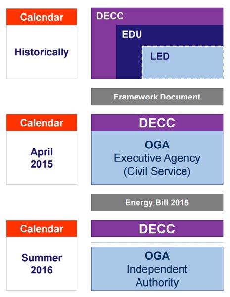
11 What is the future role of GIS at the OGA? Improve data quality and availability OGA to co-ordinate data quality and sharing Call to Action: Six months on September 2015 OGA Overview September 2015 Improve the quantity, timeliness and reliability of data and information available internally to the OGA and externally to industry Call to Action: The OGA Commission February 2015 Provide high-quality geological maps such as play fairway maps integrating with neighboring countries including Norway OGA Corporate Plan March 2016 The OGA are in a unique position of having information that many operators/other industry bodies do not have Publish the OGA geospatial strategy Guide to Building the OGA August 2015 IM Strategy October Open Data for the North Sea & Beyond


12 12 Open Data for the North Sea & Beyond
13 National Data Repositories UK: OGA centre/ UK: CDA Norway: NPD maps/ Netherlands: NLOG digital files Denmark: DEA services/oil and gas related data/shape files maps Poland: PGI bases.html Spain: IGME France: BEPH ORKUSTOFNUN : Iceland JARDFEINGI : Faroe Islands LEGMC : Latvia PetroBank MDS : Turkey 13 Open Data for the North Sea & Beyond


14 The NPD To manage the oil & gas resources of Norway FactMaps for spatial data FactPages for field, licence, wellbores etc. Recent updates - integration maps/ factweb@npd.no 14 Open Data for the North Sea & Beyond


15 NLOG Established by the Dutch Ministry of Economic Affairs Service managed by TNO, Geological Survey of the Netherlands Oil, gas & geothermal energy data Offshore & onshore Geological data & maps Shapefile download WMS Some inconsistencies Examine currency digital files 15 Open Data for the North Sea & Beyond


16 Bringing it all together ETL tools to Extract/ download, Transform and Load Manage in ArcSDE > data models Integrate Standardise Serve 16 Open Data for the North Sea & Beyond


17 17 Maximising Economic Recovery (MER) using GIS
European Location Framework data in the ArcGIS platform
 European Location Framework data in the ArcGIS platform Presentation to: Author: Date: INSPIRE Conference 2016 Clemens Portele 26 September 2016 Why ELF? Global (e.g. UN GGIM) Regional Europe (INSPIRE
Paper UC1351. Conference: User Conference Date: 08/10/2006 Time: 8:30am-9:45am Room: Room 23-B (SDCC)
") Conference: User Conference Date: 08/10/2006 Time: 8:30am-9:45am Room: Room 23-B (SDCC) Title of Paper: Increasing the Use of GIS in the Federal Government Author Name: Miss Abstract This presentation
Conference: User Conference Date: 08/10/2006 Time: 8:30am-9:45am Room: Room 23-B (SDCC) Title of Paper: Increasing the Use of GIS in the Federal Government Author Name: Miss Abstract This presentation
Introduction to ArcGIS Maps for Office. Greg Ponto Scott Ball
 Introduction to ArcGIS Maps for Office Greg Ponto Scott Ball Agenda What is Maps for Office? Platform overview What are Apps for the Office? ArcGIS Maps for Office features - Visualization - Geoenrichment
Data Aggregation with InfraWorks and ArcGIS for Visualization, Analysis, and Planning
 Data Aggregation with InfraWorks and ArcGIS for Visualization, Analysis, and Planning Stephen Brockwell President, Brockwell IT Consulting, Inc. Join the conversation #AU2017 KEYWORD Class Summary Silos
Overview. Everywhere. Over everything.
 Cadenza Desktop Cadenza Web Cadenza Mobile Cadenza Overview. Everywhere. Over everything. The ultimate GIS and reporting suite. Provide, analyze and report data efficiently. For desktop, web and mobile.
One platform for desktop, web and mobile
 One platform for desktop, web and mobile Search and filter Get access to all data thematically filter data in context factually and spatially as well as display it dynamically. Export a selection or send
INSPIRE implementation in the Turkish Ministry of Environment and Urbanization Producing and Publishing Environmental Data
 INSPIRE implementation in the Turkish Ministry of Environment and Urbanization Producing and Publishing Environmental Data Ezgi Sarmusak Urban Planner, MoEU Sibel Süer Toybıyık - Assistant Expert, MoEU
Spatial Data Infrastructure Concepts and Components. Douglas Nebert U.S. Federal Geographic Data Committee Secretariat
 Spatial Data Infrastructure Concepts and Components Douglas Nebert U.S. Federal Geographic Data Committee Secretariat August 2009 What is a Spatial Data Infrastructure (SDI)? The SDI provides a basis for
Project EuroGeoNames (EGN) Results of the econtentplus-funded period *
 Results of the econtentplus-funded period *") UNITED NATIONS Working Paper GROUP OF EXPERTS ON No. 33 GEOGRAPHICAL NAMES Twenty-fifth session Nairobi, 5 12 May 2009 Item 10 of the provisional agenda Activities relating to the Working Group on Toponymic
UNITED NATIONS Working Paper GROUP OF EXPERTS ON No. 33 GEOGRAPHICAL NAMES Twenty-fifth session Nairobi, 5 12 May 2009 Item 10 of the provisional agenda Activities relating to the Working Group on Toponymic
Geospatial Information for Disease Prevention and Control. INSPIRE Conference 2013
 Geospatial Information for Disease Prevention and Control Dr. Virginia Estevez, Senior Expert GIS Florence, 25 th June 2013 ECDC overview ECDC The European Centre for Disease Prevention and Control (ECDC),
EMODne Entry Portal Steering Committee, Brussels, 16 December Alan Stevenson, Jonathan Lowndes (British Geological Survey) and the project team
 and the project team") EMODnet Geology EMODne Entry Portal Steering Committee, Brussels, 16 December 2013 Alan Stevenson, Jonathan Lowndes (British Geological Survey) and the project team Background 14 organisations participated
EMODnet Geology EMODne Entry Portal Steering Committee, Brussels, 16 December 2013 Alan Stevenson, Jonathan Lowndes (British Geological Survey) and the project team Background 14 organisations participated
TRANSVERSE GIS FOR TOTAL E&P NIGERIA - GEOPS
 TRANSVERSE GIS FOR TOTAL E&P NIGERIA - GEOPS Marc Roussel / Total H. ANEKE (Manager Survey & Geomatics) J-M. AMOUROUX (Head of Geomatics and Affiliate Transverse GIS Coordinator) TEPNG/TS/ECP/Survey &
Jeroen Hogeboom. Advisor Information Management PDOK Kadaster (Cadastre, Land Registry, Mapping Agency of NL) Introduction
 Introduction") Jeroen Hogeboom Advisor Information Management PDOK Kadaster (Cadastre, Land Registry, Mapping Agency of NL) Introduction Outline About PDOK Data processing Architecture Using PDOK Statistics Monitoring
Jeroen Hogeboom Advisor Information Management PDOK Kadaster (Cadastre, Land Registry, Mapping Agency of NL) Introduction Outline About PDOK Data processing Architecture Using PDOK Statistics Monitoring
v WMS Tutorials GIS Module Importing, displaying, and converting shapefiles Required Components Time minutes
 v. 11.0 WMS 11.0 Tutorial Importing, displaying, and converting shapefiles Objectives This tutorial demonstrates how to import GIS data, visualize it, and convert it into WMS coverage data that could be
Free and Open Source Software for Cadastre and Land Registration : A Hidden Treasure? Gertrude Pieper Espada. Overview
 Free and Open Source Software for Cadastre and Land Registration : A Hidden Treasure? Gertrude Pieper Espada Overview FLOSS concepts Digital Land Administration systems FLOSS Database alternatives FLOSS
GSDI Global Spatial Data Infrastructure. Convergences between Geo Spatial Communities: key decision for decision making
 GSDI Global Spatial Data Infrastructure Convergences between Geo Spatial Communities: key decision for decision making April 14 th 2010 Bas Kok GSDI Past-President Director of International Affairs, Dutch
Malaysia. Country Report. Oil and Gas Database Management. April 1-3, 2009
 April 1-3, 2009 Malaysia Country Report Oil and Gas Database Management The Legislative Framework of the Malaysian Petroleum Industry Relationship between the Government, PETRONAS and PSC Contractors Objectives
Roadmap to interoperability of geoinformation
 Roadmap to interoperability of geoinformation and services in Europe Paul Smits, Alessandro Annoni European Commission Joint Research Centre Institute for Environment and Sustainability paul.smits@jrc.it
Land Board, NW Services and SDI Tambet Tiits, FRICS
 Land Board, NW Services and SDI Tambet Tiits, FRICS 07.09.2016 200th anniversary of the Struve Geodetic Arc Friedrich Georg Wilhelm Struve and Carl Friedrich Tenner Struve Geodetic Arc The Struve Geodetic
A New Approach to GIS at the Ministry for Primary Industries New Zealand
 A New Approach to GIS at the Ministry for Primary Industries New Zealand Alana Corney and André Post Geospatial Management Team www.mpi.govt.nz 1 Overview Who we are and what we do Our Approach Building
a national geological survey perspective François ROBIDA BRGM (French Geological Survey)
") a national geological survey perspective François ROBIDA BRGM (French Geological Survey) Pre-Conference Seminar on Socio-Economic Value of Geospatial for National and Regional Development 21 August 2017,
a national geological survey perspective François ROBIDA BRGM (French Geological Survey) Pre-Conference Seminar on Socio-Economic Value of Geospatial for National and Regional Development 21 August 2017,
ELF products in the ArcGIS platform
 ELF products in the ArcGIS platform Presentation to: Author: Date: NMO Summit 2016, Dublin, Ireland Clemens Portele 18 May 2016 The Building Blocks 18 May, 2016 More ELF users through affiliated platforms
Leveraging ArcGIS Online Elevation and Hydrology Services. Steve Kopp, Jian Lange
 Leveraging ArcGIS Online Elevation and Hydrology Services Steve Kopp, Jian Lange Topics An overview of ArcGIS Online Elevation Analysis Using Elevation Analysis Services in ArcGIS for Desktop Using Elevation
Data Aggregation with InfraWorks and ArcGIS for Visualization, Analysis, and Planning
 CI125230 Data Aggregation with InfraWorks and ArcGIS for Visualization, Analysis, and Planning Stephen Brockwell Brockwell IT Consulting Inc. Sean Kinahan Brockwell IT Consulting Inc. Learning Objectives
ISU GIS CENTER S ARCSDE USER'S GUIDE AND DATA CATALOG
 ISU GIS CENTER S ARCSDE USER'S GUIDE AND DATA CATALOG 2 TABLE OF CONTENTS 1) INTRODUCTION TO ARCSDE............. 3 2) CONNECTING TO ARCSDE.............. 5 3) ARCSDE LAYERS...................... 9 4) LAYER
GeoSUR SRTM 30-m / TPS
 GeoSUR SRTM 30-m / TPS Wm Matthew Cushing (USGS) 16 May 2013 U.S. Department of the Interior U.S. Geological Survey SRTM Mission Shuttle Radar Topography Mission (SRTM) Space Shuttle Endeavour during the
ArcGIS for INSPIRE. Marten Hogeweg
 ArcGIS for INSPIRE Marten Hogeweg Please Take Our Survey on the App Download the Esri Events app and find your event Select the session you attended Scroll down to find the feedback section Complete answers
Implementing INSPIRE Geoportal in Turkey
 Implementing INSPIRE Geoportal in Turkey Gencay SERTER City and Regional Planner 1 Presentation Plan Introduction INSPIRE and Turkey Importance of al Spatial Planning Portal Logical&Legal Hierarchy GeoPortal
Imagery and the Location-enabled Platform in State and Local Government
 Imagery and the Location-enabled Platform in State and Local Government Fred Limp, Director, CAST Jim Farley, Vice President, Leica Geosystems Oracle Spatial Users Group Denver, March 10, 2005 TM TM Discussion
ONSDI Services Enabling GeoSmart Oman
 ONSDI Services Enabling GeoSmart Oman Oman National Spatial Data Infrastructure Enabling GeoSmart Oman Majid AlBusaidi Section Head Technology & Operations, Directorate General of National Spatial Data
ArcGIS. for Server. Understanding our World
 ArcGIS for Server Understanding our World ArcGIS for Server Create, Distribute, and Manage GIS Services You can use ArcGIS for Server to create services from your mapping and geographic information system
Corporate. Information. Railway Infrastructure Administrator. Year indracompany.com
 geospatial and mobility Corporate Geographic Information System of ADIF Railway Infrastructure Administrator. Year 2009-2010 Corporate Geographic Information System of ADIF ADIF. Spanish Administrator
Arctic Spatial Data Infrastructure Enabling Access to Arctic Location-Based Information
 Arctic Spatial Data Infrastructure Enabling Access to Arctic Location-Based Information Arctic SDI Side Event Co-Chairs: Arvo Kokkonen Arctic SDI Board Chair & Director General, National Land Survey of
Leveraging the OGC Capabilities of ArcGIS Server
 Leveraging the OGC Capabilities of ArcGIS Server Satish Sankaran Interoperability and Standards Team Yingqi Tang Server Team Jessica Parteno Geodatabase Team ArcGIS Server is Open & Interoperable Using
SITMUN: Cooperating to Build Local SDIs in the Barcelona Region
 SITMUN: Cooperating to Build Local SDIs in the Barcelona Region Diputació de Barcelona Territory and Sustainability Area Territorial Information Systems Department INSPIRE CONFERENCE Barcelona, September
Pan-Arctic Digital Elevation Map (Pan-Arctic DEM)
") Memorandum to CAFF Board 07/28/2017 BACKGROUND: Pan-Arctic Digital Elevation Map (Pan-Arctic DEM) ArcticDEM is a National Geospatial-Intelligence Agency (NGA)-National Science Foundation (NSF) publicprivate
Memorandum to CAFF Board 07/28/2017 BACKGROUND: Pan-Arctic Digital Elevation Map (Pan-Arctic DEM) ArcticDEM is a National Geospatial-Intelligence Agency (NGA)-National Science Foundation (NSF) publicprivate
INSPIRing effort. Peter Parslow Ordnance Survey December Various European approaches to managing an SDI
 INSPIRing effort Peter Parslow Ordnance Survey December 2015 Various European approaches to managing an SDI WHAT IS INSPIRE? A European Union Directive A community effort: http://inspire.ec.europa.eu/
ArcGIS GeoAnalytics Server: An Introduction. Sarah Ambrose and Ravi Narayanan
 ArcGIS GeoAnalytics Server: An Introduction Sarah Ambrose and Ravi Narayanan Overview Introduction Demos Analysis Concepts using GeoAnalytics Server GeoAnalytics Data Sources GeoAnalytics Server Administration
Digital Datasets Available from the Exploration & Mining Division. Dr. Wayne R. Cox, Senior Geologist, Exploration & Mining Division, DCENR.
 Digital Datasets Available from the Exploration & Mining Division Dr. Wayne R. Cox, Senior Geologist, Exploration & Mining Division, DCENR. Who Are EMD? Line Division of DCENR Small Unit (4 Geological
Gridded Ambient Air Pollutant Concentrations for Southern California, User Notes authored by Beau MacDonald, 11/28/2017
 Gridded Ambient Air Pollutant Concentrations for Southern California, 1995-2014 User Notes authored by Beau, 11/28/2017 METADATA: Each raster file contains data for one pollutant (NO2, O3, PM2.5, and PM10)
A decade of geoinformation sharing at ETH Zurich
 A decade of geoinformation sharing at ETH Zurich Ionuț Iosifescu-Enescu, Cristina Iosifescu-Enescu, Nadia H. Panchaud, Angeliki Tsorlini, Lorenz Hurni {iosifescu,ciosifescu,nadia.panchaud,atsorlini,lhurni}@ethz.ch
Technical Specifications. Form of the standard
 Used by popular acceptance Voluntary Implementation Mandatory Legally enforced Technical Specifications Conventions Guidelines Form of the standard Restrictive Information System Structures Contents Values
EMODnet High Resolution Seabed Mapping - further developing a high resolution digital bathymetry for European seas
 EMODnet High Resolution Seabed Mapping - further developing a high resolution digital bathymetry for European seas IMDIS 2018 Conference, 7 November 2018, Barcelona - Spain Thierry Schmitt Dick M.A. Schaap
Geologi for samfunnet
 Implementing Inspire Download Services using Open Source and FME Software at Geological Survey of Norway Bjørn Ove Grøtan - NGU FMEDagarna 11-12th October 2010 Geologi for samfunnet About Geological survey
Homeland Security Geospatial Data Model. Mark Eustis SAIC Joe Kelly Traverse Technologies 21 February, 2008
 Homeland Security Geospatial Data Model Mark Eustis SAIC Joe Kelly Traverse Technologies 21 February, 2008 Background & Landscape For whom are we doing this? the homeland security community But why build
GTK GeoKernel and Data Management. Material from Niina Ahtonen, Esa Kauniskangas and Tero Rönkkö
 GTK GeoKernel and Data Management Esa Kauniskangas 31.5.2010 Material from Niina Ahtonen, Esa Kauniskangas and Tero Rönkkö 1 GTK s operational areas Northern Finland Office Rovaniemi Western Finland Office
Second Administrative Level Boundaries (SALB) initiative & geographic names in cartography. Geospatial Information Section
 initiative & geographic names in cartography. Geospatial Information Section") Second Administrative Level Boundaries (SALB) initiative & geographic names in cartography Geospatial Information Section Introduction Goals Global agenda How does SALB work? Latest News on geographic
Second Administrative Level Boundaries (SALB) initiative & geographic names in cartography Geospatial Information Section Introduction Goals Global agenda How does SALB work? Latest News on geographic
Reprint of article that appeared in Hydro INTERNATIONAL November 2006 Volume 10 Issue 9
 Reprint of article that appeared in Hydro INTERNATIONAL November 2006 Volume 10 Issue 9 While Google Earth is the best known 3D web-mapping viewer currently in the public domain, there are alternative
Nord Stream 2 A story of gas pipelines and GIS technology from the start. Cécile Noverraz GIS Analyst
 Nord Stream 2 A story of gas pipelines and GIS technology from the start 30-10-2018 Cécile Noverraz GIS Analyst Presentation - Outline >Project Overview > Initial GIS Project Setup > Project Data > GIS
INSPIRE Shared Service
 INSPIRE Shared Service Creation and operation out of the box Petra Fritz (HZD), Michael Voigtländer (Esri Deutschland GmbH) INSPIRE Shared Service Agenda HZD backbone for a geodata infrastructure Implementing
National Geospatial Platforms Solution to interoperability challenge in Europe. Antti Jakobsson Programme manager National Land Survey of Finland
 National Geospatial Platforms Solution to interoperability challenge in Europe Antti Jakobsson Programme manager National Land Survey of Finland 1 Questionnaire made in 2017: Google search: Public Geospatial
Hosted by Esri Official Distributor
 Hosted by Esri Official Distributor Esri European User Conference October 15-17, 2012 Oslo, Norway Hosted by Esri Official Distributor Interoperability and Standards Support in ArcGIS 10.1 Roberto Lucchi
Geospatial Standards Support - An Overview. Marten Hogeweg & Satish Sankaran
 Geospatial Standards Support - An Overview Marten Hogeweg & Satish Sankaran Agenda Interoperability and Standards ArcGIS Open, Interoperable and Standards Compliant Esri Open initiatives Understanding
Marine Spatial Management Tool
 Marine Spatial Management Tool Marine Spatial Management Tool Support the marine spatial planning process with updated and reliable geospatial information Marine management is important to Norway with
Regional EGM on Community of Practice of Georeferenced Information System. for Disaster Risk Management (Geo-DRM) April 2014, Bangkok, Thailand
 April 2014, Bangkok, Thailand") Regional EGM on Community of Practice of Georeferenced Information System for Disaster Risk Management (Geo-DRM) 23-25 April 2014, Bangkok, Thailand Presented By Mukesh Kumar Keshari Ministry of Home Affairs
Regional EGM on Community of Practice of Georeferenced Information System for Disaster Risk Management (Geo-DRM) 23-25 April 2014, Bangkok, Thailand Presented By Mukesh Kumar Keshari Ministry of Home Affairs
Journey to create opportunities in Sierra Leone using Esri s ArcGIS Platform Presented by:
 Journey to create opportunities in Sierra Leone using Esri s ArcGIS Platform Presented by: John Clark, Getech Group Plc, on behalf of The Petroleum Directorate Sierra Leone Summary The mission of the Petroleum
What Would John Snow Do (Today)? Part 1
? Part 1") What Would John Snow Do (Today)? Part 1 Tanya Bigos and Derek Law @Tanyabigos @GIS_Bandit Thurs Oct 19 th, 2017 Outline Overview of the ArcGIS Platform Whiteboard discussion Summary Questions A Whole New
What Would John Snow Do (Today)? Part 1 Tanya Bigos and Derek Law @Tanyabigos @GIS_Bandit Thurs Oct 19 th, 2017 Outline Overview of the ArcGIS Platform Whiteboard discussion Summary Questions A Whole New
GIS ADMINISTRATOR / WEB DEVELOPER EVANSVILLE-VANDERBURGH COUNTY AREA PLAN COMMISSION
 GIS ADMINISTRATOR / WEB DEVELOPER EVANSVILLE-VANDERBURGH COUNTY AREA PLAN COMMISSION SALARY RANGE INITIATION $43,277 SIX MONTHS $45,367 POSITION GRADE PAT VI The Evansville-Vanderburgh County Area Plan
African Coastal Atlas developments. 10 July 2008 EEA Copenhagen, Denmark
 African Coastal Atlas developments 10 July 2008 EEA Copenhagen, Denmark Africa Overview Africa has approximately 40 000 km of coast across 32 mainland countries and four island states. Africa's coastal
Keywords: Wind resources assessment, Wind maps, Baltic Sea, GIS
 Advanced Materials Research Online: 2013-10-31 ISSN: 1662-8985, Vol. 827, pp 153-156 doi:10.4028/www.scientific.net/amr.827.153 2014 Trans Tech Publications, Switzerland Mapping of Offshore Wind Climate
COUNTRY REPORT ON CARTOGRAPHIC ACTIVITIES IN SINGAPORE ( ) Submitted by Singapore **
 Submitted by Singapore **") UNITED NATIONS E/CONF.97/5/CRP. 9 ECONOMIC AND SOCIAL COUNCIL Seventeenth United Nations Regional Cartographic Conference for Asia and the Pacific Bangkok, 18-22 September 2006 Item 6 (b) of the provisional
UNITED NATIONS E/CONF.97/5/CRP. 9 ECONOMIC AND SOCIAL COUNCIL Seventeenth United Nations Regional Cartographic Conference for Asia and the Pacific Bangkok, 18-22 September 2006 Item 6 (b) of the provisional
INTERNATIONAL HYDROGRAPHIC REVIEW MAY 2013
 A TECHNICAL METHOD ON CALCULATING THE LENGTH OF COASTLINE FOR COMPARISON PURPOSES Laurent LOUVART (Eng. Corps & Hydrograph., SHOM - FRANCE) on behalf of the IHO Correspondence Group Abstract A quick web
Grant Agreement No. EIE/07/595/SI BEn
 Biomass energy register for sustainable site development for European regions Grant Agreement No. EIE/07/595/SI2.499697 BEn Biomass energy register for sustainable site development for European regions
SDI Standards at work
 SDI Standards at work Jan Juul Jensen Senior Technology Strategist Informi GIS Denmark Informi GIS Private held Limited Company Specialized in GIS 100+ employees HQ in Charlottenlund, Copenhagen Regional
Evaluating Physical, Chemical, and Biological Impacts from the Savannah Harbor Expansion Project Cooperative Agreement Number W912HZ
 Evaluating Physical, Chemical, and Biological Impacts from the Savannah Harbor Expansion Project Cooperative Agreement Number W912HZ-13-2-0013 Second Quarterly Report - 2017 Submitted by Sergio Bernardes
2012 OCEAN DRILLING CITATION REPORT
 2012 OCEAN DRILLING CITATION REPORT Covering Citations Related to the Deep Sea Drilling Project, Ocean Drilling Program, and Integrated Ocean Drilling Program from GeoRef Citations Indexed by the American
Evaluating Physical, Chemical, and Biological Impacts from the Savannah Harbor Expansion Project Cooperative Agreement Number W912HZ
 Evaluating Physical, Chemical, and Biological Impacts from the Savannah Harbor Expansion Project Cooperative Agreement Number W912HZ-13-2-0013 Annual Report FY 2018 Submitted by Sergio Bernardes and Marguerite
Funding systems used in Mexico to support institutional arrangements: INEGI case
 Funding systems used in Mexico to support institutional arrangements: INEGI case Sistemas de financiamiento usados en México, para soportar arreglos institucionales: Caso INEGI United Nations Committee
Testing of Geoportals: INSPIRE demands and challenges
 Testing of Geoportals: INSPIRE demands and challenges Imad Abugessaisa & Solgerd Tanzilli Lantmäteriet - Swedish Mapping, Cadastre and Land Registration Authority / Future Position X, Gävle INSPIRE 2010
Use of the ISO Quality standards at the NMCAs Results from questionnaires taken in 2004 and 2011
 Use of the ISO 19100 Quality standards at the NMCAs Results from questionnaires taken in 2004 and 2011 Eurogeographics Quality Knowledge Exchange Network Reference: History Version Author Date Comments
Assessing the Robustness of Web Feature Services Necessary to Satisfy the Requirements of Coastal Management
 Assessing the Robustness of Web Feature Services Necessary to Satisfy the Requirements of Coastal Management Jennifer Bauer M.S. Geography GISci Certificate June 4, 2012 Presentation Outline!! Background
U s i n g t h e E S A / E U M E T C A S T N a v i g a t o r s
 U s i n g t h e E S A / E U M E T C A S T N a v i g a t o r s Copernicus User Uptake Information Sessions Copernicus EU Copernicus EU Copernicus EU www.copernicus.eu I N T R O D U C T I O N O F U S E C
Existing Open Source Tools and Possibilities for Cadastre Systems
 Existing Open Source Tools and Possibilities for Cadastre Systems Gertrude Pieper Espada FIG Congress Sydney, 11-16 April 2010 What is FLOSS? What is open source? What open source software tools are available?
Geog 469 GIS Workshop. Managing Enterprise GIS Geodatabases
 Geog 469 GIS Workshop Managing Enterprise GIS Geodatabases Outline 1. Why is a geodatabase important for GIS? 2. What is the architecture of a geodatabase? 3. How can we compare and contrast three types
CAPE FARM MAPPER - an integrated spatial portal
 CAPE FARM MAPPER - an integrated spatial portal Skukuza Dr Mike Wallace June 2017 Overview of GIS applications in WCDoA Spatial information and technology has become indispensable across a wide range of
IHO STAKEHOLDERS FORUM. Hydrographic data and its role in MSDI. Thursday 27 September Jens Peter Hartmann KMS
 IHO STAKEHOLDERS FORUM Hydrographic data and its role in MSDI Thursday 27 September Jens Peter Hartmann KMS Agenda Traditional approach to hydrographic data Expectations within the marine / maritime field
THE WASHINGTON COASTAL ATLAS
 THE ICAN COASTAL ATLAS MEDIATOR PROTOTYPE AND CONNECTING THE WASHINGTON COASTAL ATLAS Liz O Dea 1, Yassine Lassoued 2, Tanya Haddad 3, Declan Dunne 2 1 GIS Services Unit, WA State Dept. of Ecology 2 Coastal
Geospatial Decision Support Tools for Planning of Marine Protected Areas in California
 Geospatial Decision Support Tools for Planning of Marine Protected Areas in California WILL MCCLINTOCK (UNIVERSITY OF CALIFORNIA SANTA BARBARA), MATT MERRIFIELD (THE NATURE CONSERVANCY), SOPHIE DE BEUKELAER
3D-NORGE: A NEW PROJECT TO BUILD A 3D BEDROCK MAP OF NORWAY
 3D-NORGE: A NEW PROJECT TO BUILD A 3D BEDROCK MAP OF NORWAY Henderson; I.H.C. & Grøtan, B.O. Geological Survey of Norway, Leif Eirikssons Veg 39, 7491, Trondheim, iain.henderson@ngu.no 1. INTRODUCTION
Reducing Complex Spatial Data Management Needs in and Upstream Oil and Gas Operations Team. Jason Wilson GIS Business Analyst SM Energy
 Reducing Complex Spatial Data Management Needs in and Upstream Oil and Gas Operations Team Jason Wilson GIS Business Analyst SM Energy Agenda About Myself and SM Energy The Challenge The Goal Solution
GeoPostcodes. Denmark
 Denmark Denmark About.com Launched in 2007, website offers comprehensive and reliable databases of localities, streets, administrative regions, ZIP/postal codes and lots of other information for all countries.
Why GIS & Why Internet GIS?
 Why GIS & Why Internet GIS? The Internet bandwagon Internet mapping (e.g., MapQuest) Location-based services Real-time navigation (e.g., traffic) Real-time service dispatch Business Intelligence Spatial
Regione Umbria. ESRI EMEA User Conference 2010 Rome, October 27th 2010
 Direzione Ambiente, Territorio e Infrastrutture Servizio Informatico/Informativo: geografico, ambientale e territoriale ESRI EMEA User Conference 2010 Rome, October 27th 2010 Arch. Ambra Ciarapica, Dott.
UTAH S STATEWIDE GEOGRAPHIC INFORMATION DATABASE
 UTAH S STATEWIDE GEOGRAPHIC INFORMATION DATABASE Data Information and Knowledge Management NASCIO Awards 2009 STATE GEOGRAPHIC INFORMATION DATABASE B. EXECUTIVE SUMMARY Utah has developed one of the most
Innovation. The Push and Pull at ESRI. September Kevin Daugherty Cadastral/Land Records Industry Solutions Manager
 Innovation The Push and Pull at ESRI September 2004 Kevin Daugherty Cadastral/Land Records Industry Solutions Manager The Push and The Pull The Push is the information technology that drives research and
HertfordshireCC GIS Standards (draft) Contents
 Contents") Standards for Geographic Information Systems Contents Requirements for the procurement of systems with mapping/gis functionality...2 Background...2 System Requirements...2 HCC Corporate Standard for Spatial
Standards for Geographic Information Systems Contents Requirements for the procurement of systems with mapping/gis functionality...2 Background...2 System Requirements...2 HCC Corporate Standard for Spatial
IRDAT Fvg, evolving a regional Spatial Data Infrastructure according to INSPIRE
 IRDAT Fvg, evolving a regional Spatial Data Infrastructure according to INSPIRE Tutti i diritti riservati. Proprietà INSIEL SpA. A. Benvenuti, A. Chiarandini Insiel (Italy) M. Lunardis - Friuli Venezia
What is OneGeology in 2015?
 What is OneGeology in 2015? 25th May 2015 Marko Komac OneGeology Managing Director Presentation Outline Background quick OneGeology history Consortium The vehicle to achieve the goal Current status Where
SoilView: Development of a Custom GIS Application for Publishing Soil Surveys
 SoilView: Development of a Custom GIS Application for Publishing Soil Surveys Allan Johnson and Mike Wigginton Abstract Currently, digital soils information can be obtained from many sources. Numerous
Economic and Social Council 2 July 2015
 ADVANCE UNEDITED VERSION UNITED NATIONS E/C.20/2015/11/Add.1 Economic and Social Council 2 July 2015 Committee of Experts on Global Geospatial Information Management Fifth session New York, 5-7 August
Introduction to Portal for ArcGIS
 Introduction to Portal for ArcGIS Derek Law Product Management March 10 th, 2015 Esri Developer Summit 2015 Agenda Web GIS pattern Product overview Installation and deployment Security and groups Configuration
8 th Arctic Regional Hydrographic Commission Meeting September 2018, Longyearbyen, Svalbard Norway
 8 th Arctic Regional Hydrographic Commission Meeting 11-13 September 2018, Longyearbyen, Svalbard Norway Status Report of the Arctic Regional Marine Spatial Data Infrastructures Working Group (ARMSDIWG)
Evaluating Physical, Chemical, and Biological Impacts from the Savannah Harbor Expansion Project Cooperative Agreement Number W912HZ
 Evaluating Physical, Chemical, and Biological Impacts from the Savannah Harbor Expansion Project Cooperative Agreement Number W912HZ-13-2-0013 FY 2016 - First Quarterly Report January 1, 2016 Submitted
Creating Basemaps to Manage Buildings and Facilities
 Esri International User Conference San Diego, California Technical Workshops July 26, 2012 Creating Basemaps to Manage Buildings and Facilities Mark Stewart and Tamara Yoder Topics for this Session Overview
These modules are covered with a brief information and practical in ArcGIS Software and open source software also like QGIS, ILWIS.
 Online GIS Training and training modules covered are: 1. ArcGIS, Analysis, Fundamentals and Implementation 2. ArcGIS Web Data Sharing 3. ArcGIS for Desktop 4. ArcGIS for Server These modules are covered
DP Project Development Pvt. Ltd.
 Dear Sir/Madam, Greetings!!! Thanks for contacting DP Project Development for your training requirement. DP Project Development is leading professional training provider in GIS technologies and GIS application
INTRODUCTION TO ARCGIS Version 10.*
 Week 3 INTRODUCTION TO ARCGIS Version 10.* topics of the week Overview of ArcGIS Using ArcCatalog Overview of ArcGIS Desktop ArcGIS Overview Scalable desktop applications ArcView ArcEditor ArcInfo ArcGIS
SOLUTIONS ADVANCED GIS. TekMindz are developing innovative solutions that integrate geographic information with niche business applications.
 ADVANCED GIS SOLUTIONS TekMindz are developing innovative solutions that integrate geographic information with niche business applications. TEK INDZ TM GIS Services Overview At the leading edge of geospatial
Hurricanes Katrina and Rita created the largest natural disaster in American history
 Overview of the Road Home Program Hurricanes Katrina and Rita created the largest natural disaster in American history In Louisiana: 123,000 homes suffered major damage 82,000 rental properties suffered
Leveraging Web GIS: An Introduction to the ArcGIS portal
 Leveraging Web GIS: An Introduction to the ArcGIS portal Derek Law Product Management DLaw@esri.com Agenda Web GIS pattern Product overview Installation and deployment Configuration options Security options