Building a New FOSS4G Technology Workforce PHILLIP DAVIS / KURT MENKE / RICHARD SMITH / JOHN VAN HOESEN THE GEOACADEMY TEAM
|
|
|
- Sylvia Mathews
- 5 years ago
- Views:
Transcription
1 Building a New FOSS4G Technology Workforce PHILLIP DAVIS / KURT MENKE / RICHARD SMITH / JOHN VAN HOESEN THE GEOACADEMY TEAM
2 The Opportunity Global geospatial industry brings in $270 billion in annual revenue Geospatial is 5 to 10 times larger than the video game industry At least one third the size of the global airline industry (Oxera Report, January 2013 Geospatial World) Research and Markets report forecasts that the global utility GIS market will grow at a compound annual growth rate (CAGR) of 9.27 % over the period In the U.S. most of the 3000 electric power utilities are small to medium-sized organizations, primarily municipal and rural electric coops. GIS is the only foundational view that can potentially link every operational activity of an electric utility (Navigant Research, via Eclipse Foundation article Geoff Zeiss)
3 The Challenge for Open Source Adoption Less the 5% of US colleges and universities offer training in Open Source software Esri higher education group reports ArcGIS used by 7,000 colleges and universities globally Commercial FOSS4G training is far and few between and predominantly place-based F2F Lack of recognized Open Source industry certification Commercial vendors have well-established training programs and certification pathways
4 The GeoAcademy Project Experiment The brain-fart of founding director of the National Geospatial Technology Center of Excellence ( and the current GIS Project Manager for the National Information Security & Geospatial Technology Consortium ( Loose confederation of US-based GIS educators at colleges and universities with a personal passion and research interest in promoting open source GIS software in education. Curriculum development effort spanning 3 years that has resulted in an integrated collection of five introductory GIS courses featuring FOSS4G solutions for the lab component. Pedagogically based on the US Department of Labor s Geospatial Technology Competency Model (GTCM), first published in 2010 and updated in Developed using funds from US National Science Foundation and Department of Labor grants allowing all the material to be offered for free reuse under the Creative Commons BY 3.0 license.
5 GeoAcademy Project Goals Expand the use of Open Source GIS software (FOSS4G) in college and universities to prepare our future geospatial technology industry workers with the broadest possible technical skills. Provide educators and trainers with foundational Open Education Resource (OER) materials to kick-start adoption of FOSS4G in schools, colleges and universities in the US and beyond. Expand the OSGeo/ICA/ISPRS Geo for All initiative and increase the number of colleges and universities in the research collaborative ( Demonstrate the successful use of GeoAcademy materials for online learning to provide widespread training opportunities to rural, remote and underserved populations around the globe. Build a self-sustaining community of practice among educators and trainers to build, curate, share and build a FOSS4G OER repository of curriculum materials, licensed under CC BY license on stable Github platform.
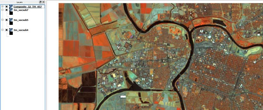
6 GeoAcademy Curriculum Consist of 5 Core Courses: GST 101 Introduction GIS GST 102 Spatial Analysis GST 103 Data Management GST 104 Cartography GST 105 Remote Sensing
7 GST 101 Introduction to Geospatial Technology Using QGIS Fundamental overview of GIS theory and practice Geospatial data models and file formats (vector, raster, etc) Data editing Georeferencing Fundamentals of cartography Introduction to remote sensing Basic spatial analysis
8 Cartography
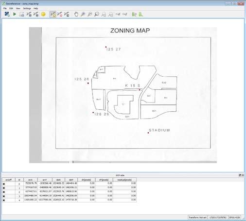
9 Georeferencing

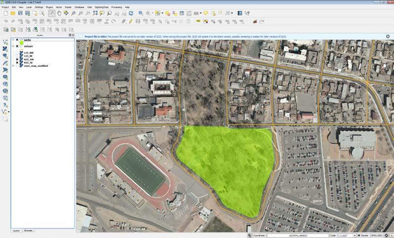
10 Basic Analysis

11 GST 102 Spatial Analysis using QGIS Prepare data for use in analysis Problem solving using geospatial tools and methods Automating workflows Present the results of a using terminology and visualizations

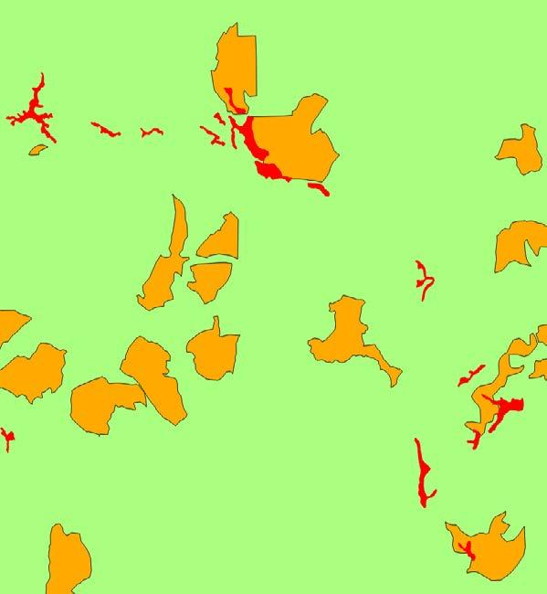
12 Vector Overlay Techniques
13 Automating Workflows
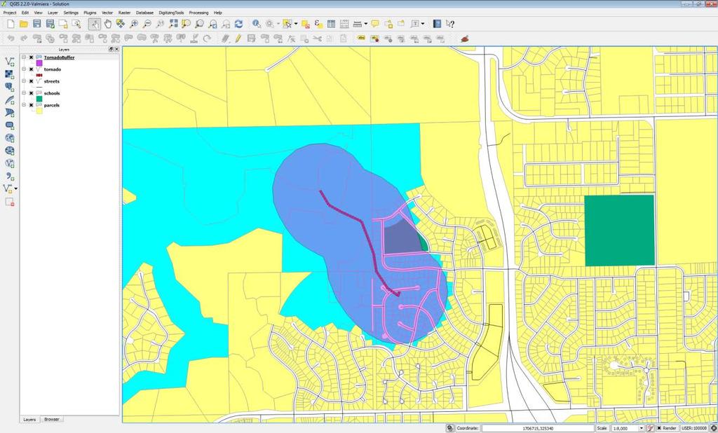
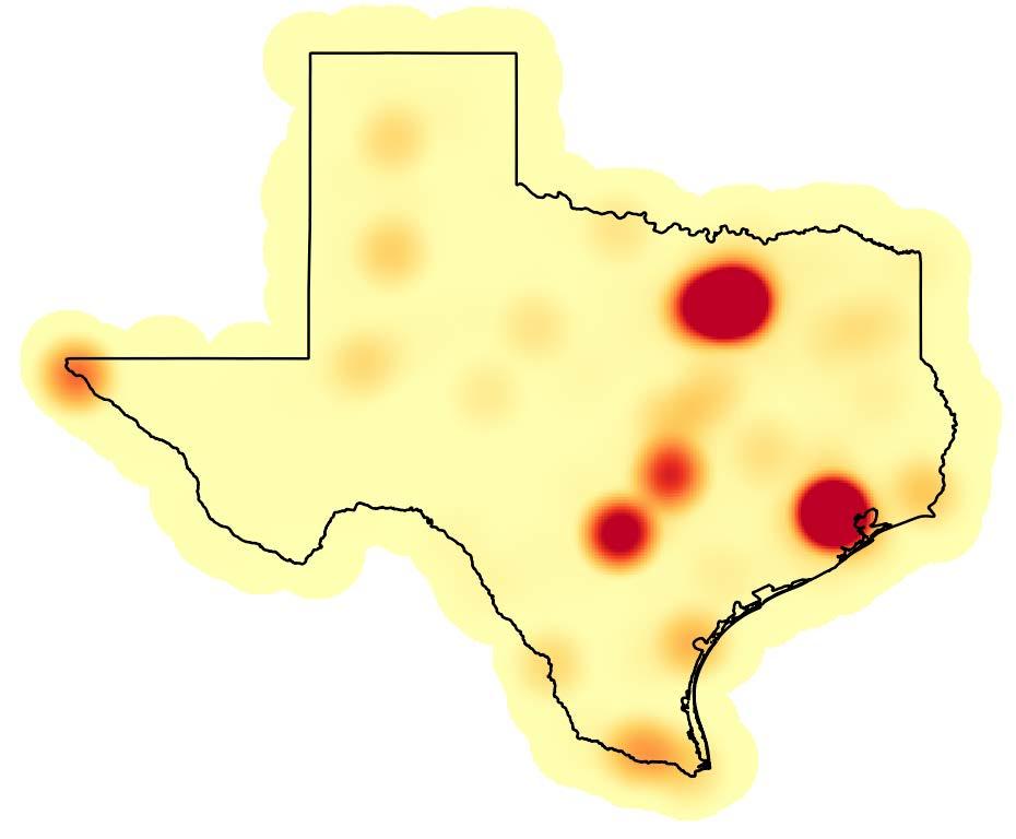

14 Heat Maps

15 Network Analysis GRASS Plugin

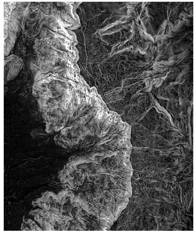
16 Terrain Analysis

17 GST 103 Data Acquisition and Management using QGIS Setting up a project database Vector data structures Spatial data quality Raster data structures Data sources


18 Setting up a Project Database using SpatiaLite
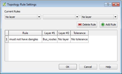
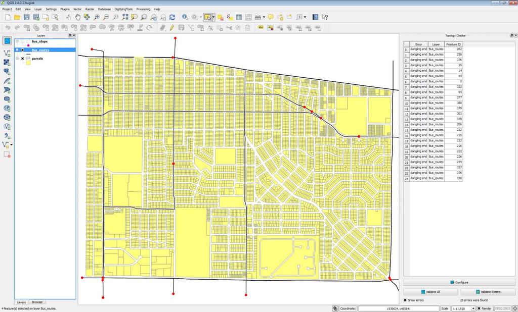

19 Topology

20 Spatial Data Quality & Metadata
 Describe the components of a map (map elements) Employ an appropriate geographic referencing system (datum, projection, coordinate system) Select and apply ethical and appropriate data model, map")
21 GST 104 Introduction to Cartography using QGIS and Inkscape Categorize and describe different types of maps (thematic, reference, etc.) Describe the components of a map (map elements) Employ an appropriate geographic referencing system (datum, projection, coordinate system) Select and apply ethical and appropriate data model, map scale, map elements, symbolization and color Design professional quality maps employing cartographic principles Critique maps for appropriate use of cartographic design principles

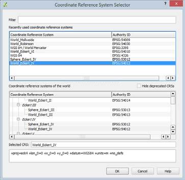
22 Working with Coordinate Systems
23 Cartography
 Select appropriate data set for remote sensing application based on spectral, temporal, radiometric and spatial resolution Describe characteristics of passive and active remote sensing systems")
24 GST Introduction to Remote Sensing using QGIS and GRASS GIS Basic concepts of remote sensing (i.e. Electromagnetic Spectrum, etc.) Select appropriate data set for remote sensing application based on spectral, temporal, radiometric and spatial resolution Describe characteristics of passive and active remote sensing systems (such as multispectral, LiDAR and Radar) Perform basic remote sensing workflows to solve problems (such as acquiring data, feature extraction, change detection, preand post-processing, create composite images and image classification) Interpret, analyze and summarize results of a remote sensing workflow
25 Band Combinations
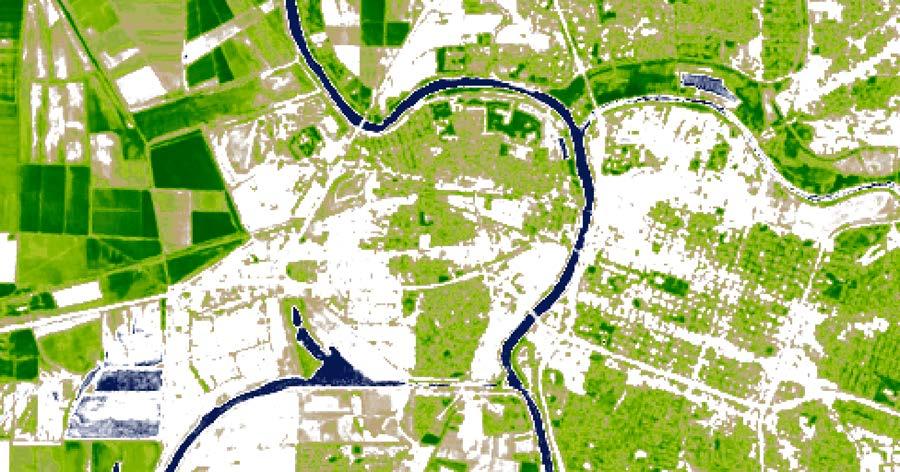
26 NDVI
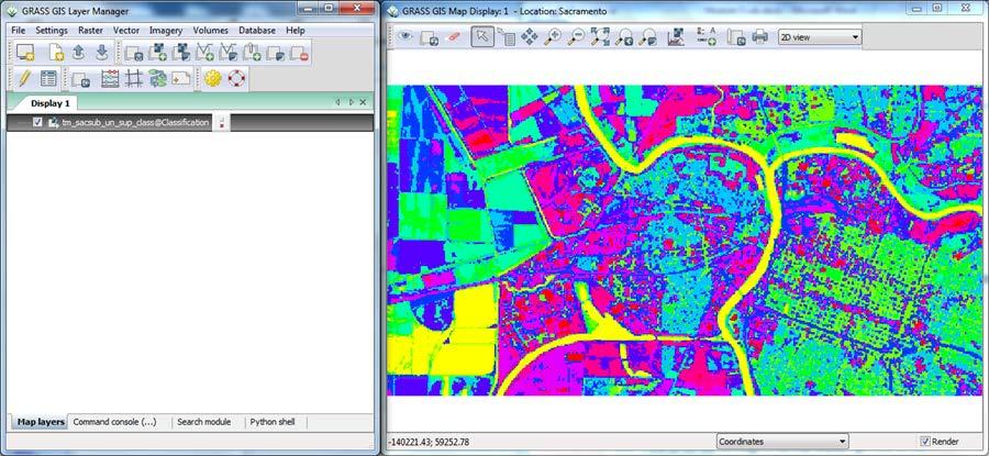
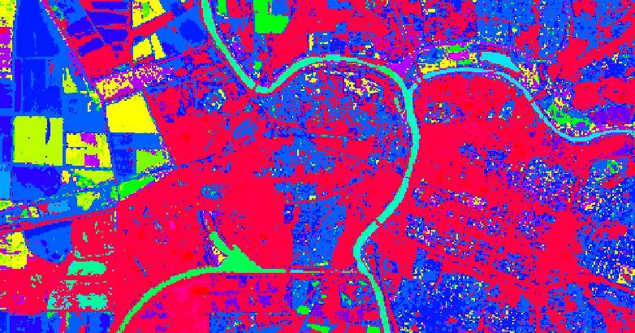
27 Supervised & Unsupervised Classification
28 The Results All five courses are published for reuse on our Github: More than 7,500 individuals have enrolled in one of our free course offering since June A dozen colleges have adopted the curriculum materials for use in their GIS programs for Our website has had more than 50,000 visits ( Partner colleges are now members of the GeoForAll initiative ( We have impacted educators, trainers, professionals, students and retirees in every continent on the globe including 3 rd world nations in Asia, Africa and South America.

29 GeoAcademy website activity since August 2014

30 GeoMOOC on Canvas Networks

31 Canvas GeoMOOC course offering March 2015

32 GeoMOOC Landing page (1 of 2)

33 GeoMOOC landing page (2 of 2)

34 GeoMOOC reaches 4500 enrollment
35 GeoMOOC Student Testimonials At Present I am living in Bangladesh. I am working in a International development organization as a Senior Monitoring officer-m&e. As a Monitoring personal this course will help me to mapping location with population. This Course also help me to conduct baseline survey along with different study. It would be helped me to reach my GIS skill and my future career. My name is Jacob, and I am located in Tennessee in the United States. I am taking this course because I am an archaeologist by trade, and GIS has become an integral part of our modern methodology, and, as such, I am always looking for more training and knowledge in the field. I already have some experience with ArcGIS, but I am a proponent of open source technology so I jumped at the chance to become more familiar with QGIS. I am currently assessing whether QGIS is suitable for teaching some of the introduction courses to GIS and remote sensing at my faculty. Besides that I am about to finish my MSc in Geoinformation Science and Earth Observations at University of Twente (The Netherlands).
36 GeoMOOC Student Testimonials Recovering novice ESRI user determined to use QGIS, western N. Carolina (US). I perform botanical / wildlife / water / habitat surveys, conservation and minimum-impact development & natural resource use planning, ecological restoration & management planning and implementation. Goal is to be able to produce all my maps & data and manage data more efficiently. I live in Akureyri in Iceland. I have been using QGIS but without any formal learning or courses. Just learning by trial and error. Now I hope to become better and more structured QGIS user. I am based in South Africa and have always had this interest to learn about GIS and FOSSA. I am taking this course to acquire the skills necessary to carryout spatial analysis of environmental resources and understand community dynamics in a rural area.
37 GeoMOOC Student Testimonials My name is Louisa and I am currently working at a small Community Development Corporation in Boston, MA. I don't need GIS skills for my current position, but as I progress in my career they will be useful for Project Management and other jobs within the urban design field. Hello. I am Pierre-Yves. I am working for the Belgian Technical Cooperation on a water and sanitation supply project in Niger. I'm Inaki from Basque Country. I want to add skills in GIS to improve my analysis in planetary sciences. I am Rania, Researcher, National Authority for Remote Sensing & Space Sciences, Cairo, Egypt. I am teaching and researching in the areas of geospatial information technology. I have PhD in Computers and Information to specialize in information systems. I am looking to start a project on improving the quality of education using FOSS. This course is important to me because it will give me the start point in using FOSS.
38 4500 total enrolled (March ) 1100 completed first written assignment 500 completed first mapping exercise GeoMOOC Results Engagement and completion rate matches that of the recent Penn State / Esri / Coursera GeoINT MOOC (21,000 enrolled with 1100 completers) Built on a shoe-string by one person and limited assistance from Canvas compared to GeoINT MOOC with Penn State + Esri + Coursera Demonstrates the potential for online offerings of FOSS4G technical training and education
39 GeoAcademy: The Future Currently rebuilding the five courses using latest QGIS with publication date in July Working with several vendors to semi-commercialize the GeoAcademy content in order to reach much broader audience and sustain the development of new and expanded materials. Pushing to gain further adoption of the QGIS curriculum through Open Education Resources organizations. Working with the GeoForAll initiative to push for much greater participation in Open Source software adoption by more colleges and universities worldwide, but especially in the US which lags well behind the EU and other regions. Wish to incorporate QGIS Project provided vendor certification into the curriculum to professionalize the material and provide income resource for QGIS Project efforts. Pending National Science Foundation proposal to fund development of a formal GeoAcademy for US higher education to spread FOSS4G among colleges and universities.
40 FOSS4G Academy websites Access to free Canvas courses: Access to paid Canvas courses: FOSS curriculum source:
41 Contacts Phillip Davis Kurt Menke John Van Hoesen Richard Smith
Open Source Software Education in Texas
 Open Source Software Education in Texas PHILLIP DAVIS / RICHARD SMITH GEOACADEMY The Challenge for Open Source Adoption OPEN SOURCE Less the 5% of US colleges and universities offer training in Free and
WHAT YOU WILL LEARN TODAY
 WHAT YOU WILL LEARN TODAY Overview of the new GeoAcademy Curriculum Background on curriculum development Curriculum alignment with national standards Description of the five GIS courses Details of the
WHAT YOU WILL LEARN TODAY
 WHAT YOU WILL LEARN TODAY Overview of the new QGIS Academy Curriculum Background on curriculum development Curriculum alignment with national standards Description of the five GIS courses Details of the
Geospatial Science and Technology Model Courses and Certificate:
 Geospatial Science and Technology Model Courses and Certificate: Guidelines and Tools to Align Curriculum to Workforce Needs Ann Johnson Associate Director gisajohnson@delmar.edu Funded by National Science
The Changing Face of Geospatial Technology
 The Changing Face of Geospatial Technology Vincent A. DiNoto, Jr. Director of GeoTech Center Vince.dinoto@kctcs.edu Based upon work supported by the National Science Foundation under Grant DUE ATE 1304591.
1. Omit Human and Physical Geography electives (6 credits) 2. Add GEOG 677:Internet GIS (3 credits) 3. Add 3 credits to GEOG 797: Final Project
 2. Add GEOG 677:Internet GIS (3 credits) 3. Add 3 credits to GEOG 797: Final Project") The Department of Geography and the Office of Professional Studies propose to modify the Master of Professional Studies in Geospatial Information Sciences (GIS) as follows: 1. Omit Human and Physical Geography
The Department of Geography and the Office of Professional Studies propose to modify the Master of Professional Studies in Geospatial Information Sciences (GIS) as follows: 1. Omit Human and Physical Geography
The National Geospatial Technology Center of Excellence and a look at the future of Geospatial Technology
 The National Geospatial Technology Center of Excellence and a look at the future of Geospatial Technology Vincent A. DiNoto, Jr. Director of GeoTech Center Vince.dinoto@kctcs.edu Based upon work supported
Rural GIS Applications Geospatial Technology Awareness
 Rural GIS Applications Geospatial Technology Awareness Mike Rudibaugh, Ph.D. Co-PI NSF GeoTech Center Geography/GIS Instructor Lake Land College mrudibau@lakeland.cc.il.us 217-234-5244 What is the GeoTech
Building open source geospatial education at research universities: where we are and what is holding us back
 42 KEYNOTE TALKS Building open source geospatial education at research universities: where we are and what is holding us back Authors - Helena Mitasova, Department of Marine, Earth, and Atmospheric Sciences,
FIRE DEPARMENT SANTA CLARA COUNTY
 DEFINITION FIRE DEPARMENT SANTA CLARA COUNTY GEOGRAPHIC INFORMATION SYSTEM (GIS) ANALYST Under the direction of the Information Technology Officer, the GIS Analyst provides geo-spatial strategic planning,
DP Project Development Pvt. Ltd.
 Dear Sir/Madam, Greetings!!! Thanks for contacting DP Project Development for your training requirement. DP Project Development is leading professional training provider in GIS technologies and GIS application
Increasing GI awareness in local authorities in Poland experiences from the INSPIRE Academy training programme
 Increasing GI awareness in local authorities in Poland experiences from the INSPIRE Academy training programme http://www.akademiainspire.pl Maria Andrzejewska, Monika Rusztecka UNEP/GRID-Warsaw Centre,
GIS Visualization: A Library s Pursuit Towards Creative and Innovative Research
 GIS Visualization: A Library s Pursuit Towards Creative and Innovative Research Justin B. Sorensen J. Willard Marriott Library University of Utah justin.sorensen@utah.edu Abstract As emerging technologies
Introduction to Coastal GIS
 Held on Tues, 1/8/13 through Thurs, 1/10/13 Location: Roger Williams University, Bristol, RI Audience: The intended audiences for this course are federal and state personnel, municipal staff and officials,
Joanne N. Halls, PhD Dept. of Geography & Geology David Kirk Information Technology Services
 Joanne N. Halls, PhD Dept. of Geography & Geology David Kirk Information Technology Services Geographic Information Systems manage and analyze data to solve spatial problems. Real World Abstraction Analysis
Geographic Systems and Analysis
 Geographic Systems and Analysis New York University Robert F. Wagner Graduate School of Public Service Instructor Stephanie Rosoff Contact: stephanie.rosoff@nyu.edu Office hours: Mondays by appointment
USGIF Essential Body of Knowledge Competency Areas
 GEOINT Job/Practice Analysis USGIF, in consultation with psychometric consultants and the GEOINT community, executed a job/practice analysis to identify common competencies within the GEOINT profession.
Programme Study Plan
 Faculty of Social and Life Sciences Programme Study Plan Geographic Information Systems Programme Code: Programme Title: TGLIT Engineering: Surveying Technology and Geographical IT Credits: 180 Programme
GIS PORTFOLIO MOHAMED MAGDY MOHAMED HUSSAIN GIS ENGINEER. UWF GIS ONLINE CERTIFICATE GIS Internship (GIS4944)
") 2012 GIS PORTFOLIO MOHAMED MAGDY MOHAMED HUSSAIN GIS ENGINEER UWF GIS ONLINE CERTIFICATE GIS Internship (GIS4944) Portfolio Table of Contents Subject... Page Personal statement/mission/philosophy... 1
2012 GIS PORTFOLIO MOHAMED MAGDY MOHAMED HUSSAIN GIS ENGINEER UWF GIS ONLINE CERTIFICATE GIS Internship (GIS4944) Portfolio Table of Contents Subject... Page Personal statement/mission/philosophy... 1
INTEGRATING GEOSPATIAL PERSPECTIVES IN THE ANTHROPOLOGY CURRICULUM AT THE UNIVERSITY OF NEW MEXICO (UNM)
") INTEGRATING GEOSPATIAL PERSPECTIVES IN THE ANTHROPOLOGY CURRICULUM AT THE UNIVERSITY OF NEW MEXICO (UNM) VERONICA ARIAS HEATHER RICHARDS JUDITH VAN DER ELST DEPARTMENT OF ANTHROPOLOGY MARCH 2005 INTEGRATING
INTEGRATING GEOSPATIAL PERSPECTIVES IN THE ANTHROPOLOGY CURRICULUM AT THE UNIVERSITY OF NEW MEXICO (UNM) VERONICA ARIAS HEATHER RICHARDS JUDITH VAN DER ELST DEPARTMENT OF ANTHROPOLOGY MARCH 2005 INTEGRATING
Among various open-source GIS programs, QGIS can be the best suitable option which can be used across partners for reasons outlined below.
 Comparison of Geographic Information Systems (GIS) software As of January 2018, WHO has reached an agreement with ESRI (an international supplier of GIS software) for an unlimited use of ArcGIS Desktop
Regional Centre for Mapping of Resources for Development (RCMRD), Nairobi, Kenya
, Nairobi, Kenya") Regional Centre for Mapping of Resources for Development (RCMRD), Nairobi, Kenya Introduction to GIS (2 weeks: 10 days) Intakes: 8 th January, 6 th February, 5th March, 3 rd. April 9 th, May 7 th, June
Regional Centre for Mapping of Resources for Development (RCMRD), Nairobi, Kenya Introduction to GIS (2 weeks: 10 days) Intakes: 8 th January, 6 th February, 5th March, 3 rd. April 9 th, May 7 th, June
Creating a Staff Development Plan with Esri
 Creating a Staff Development Plan with Esri Michael Green David Schneider Guest Presenter: Shane Feirer, University of California Esri UC 2014 Technical Workshop Agenda What is a Staff Development Plan?
Dr. Stephen J. Walsh Department of Geography, UNC-CH Fall, 2007 Monday 3:30-6:00 pm Saunders Hall Room 220. Introduction
 Geographic Information Systems Geography 491 Dr. Stephen J. Walsh Department of Geography, UNC-CH Fall, 2007 Monday 3:30-6:00 pm Saunders Hall Room 220 Introduction Organizations that have a planning,
Lesson 6: Accuracy Assessment
 This work by the National Information Security and Geospatial Technologies Consortium (NISGTC), and except where otherwise Development was funded by the Department of Labor (DOL) Trade Adjustment Assistance
CERTIFICATE PROGRAM IN
 CERTIFICATE PROGRAM IN GEOGRAPHIC INFORMATION SCIENCE Department of Geography University of Utah 260 S. Central Campus Dr., Rm 270 Salt Lake City, UT 84112-9155 801-581-8218 (voice); 801-581-8219 (fax)
geographic patterns and processes are captured and represented using computer technologies
 Proposed Certificate in Geographic Information Science Department of Geographical and Sustainability Sciences Submitted: November 9, 2016 Geographic information systems (GIS) capture the complex spatial
GTECH 380/722 Analytical and Computer Cartography Hunter College, CUNY Department of Geography
 GTECH 380/722 Analytical and Computer Cartography Hunter College, CUNY Department of Geography Fall 2014 Mondays 5:35PM to 9:15PM Instructor: Doug Williamson, PhD Email: Douglas.Williamson@hunter.cuny.edu
GIS TECHNICIAN I GIS TECHNICIAN II
 GIS TECHNICIAN I GIS TECHNICIAN II CITY OF ROSEVILLE DEFINITION To perform a variety of technical office and field work duties related to the creation and maintenance of maps, tables, graphs and other
CAS GE 365 Introduction to Geographical Information Systems. The Applications of GIS are endless
 Spring 2007 CAS GE 365 Introduction to Geographical Information Systems Boston University Department of Geography and Environment The Applications of GIS are endless images from www.esri.com CAS GE 365
PHASE 1_7 TH SESSION ARCGIS TRAINING AT KU GIS LABS: INTRODUCTION TO GIS: EXPLORING ARCCATALOG AND ARCGIS TOOLS
 PHASE 1_7 TH SESSION ARCGIS TRAINING AT KU GIS LABS: INTRODUCTION TO GIS: EXPLORING ARCCATALOG AND ARCGIS TOOLS 7 TH SESSION REPORT: 10 TH - 12 TH SEPTEMBER 2014 SCHOOL OF ENGINEERING AND TECHNOLOGY COMPUTER
ArcGIS for Desktop. ArcGIS for Desktop is the primary authoring tool for the ArcGIS platform.
 ArcGIS for Desktop ArcGIS for Desktop ArcGIS for Desktop is the primary authoring tool for the ArcGIS platform. Beyond showing your data as points on a map, ArcGIS for Desktop gives you the power to manage
Esri and GIS Education
 Esri and GIS Education Organizations Esri Users 1,200 National Government Agencies 11,500 States & Regional Agencies 30,800 Cities & Local Governments 32,000 Businesses 8,500 Utilities 12,600 NGOs 11,000
HANDBOOK OF PRECISION AGRICULTURE PRINCIPLES AND APPLICATIONS
 http://agrobiol.sggw.waw.pl/cbcs Communications in Biometry and Crop Science Vol. 2, No. 2, 2007, pp. 90 94 International Journal of the Faculty of Agriculture and Biology, Warsaw University of Life Sciences,
Experiences and Directions in National Portals"
 FIG Seminar on e-land Administration Innsbruck/Austria 2-4 June 2004 "ESRI's Experiences and Directions in National Portals" Kevin Daugherty Cadastral/Land Records Manager ESRI Topic Points Technology
Teaching GIS for Land Surveying
 Teaching GIS for Land Surveying Zhanjing (John) Yu Evergreen Valley College, San Jose, California James Crossfield California State University at Fresno, Fresno California 7/13/2006 1 Outline of the Presentation
Software. People. Data. Network. What is GIS? Procedures. Hardware. Chapter 1
 People Software Data Network Procedures Hardware What is GIS? Chapter 1 Why use GIS? Mapping Measuring Monitoring Modeling Managing Five Ms of Applied GIS Chapter 2 Geography matters Quantitative analyses
Regional Centre for Mapping of Resources for Development (RCMRD), Nairobi, Kenya
, Nairobi, Kenya") Regional Centre for Mapping of Resources for Development (RCMRD), Nairobi, Kenya Introduction GIS ( 2 weeks: 10 days) Intakes: 7 th Jan, 4 th Feb,4 th March, 1 st April 6 th May, 3 rd June, 1 st July,
Regional Centre for Mapping of Resources for Development (RCMRD), Nairobi, Kenya Introduction GIS ( 2 weeks: 10 days) Intakes: 7 th Jan, 4 th Feb,4 th March, 1 st April 6 th May, 3 rd June, 1 st July,
Improvement of the National Hydrography Dataset for US Forest Service Region 3 in Cooperation with the National Forest Service
 Improvement of the National Hydrography Dataset for US Forest Service Region 3 in Cooperation with the National Forest Service Christian L. DeCasas California State University, Northridge November 7 th,
LEHMAN COLLEGE OF THE CITY UNIVERSITY OF NEW YORK. 1. Type of Change: Change in Degree Requirements
 Alpha Number: Hegis Code 1214 Program Code: 30600 1. Type of Change: Change in Degree Requirements 2. From: [The curriculum consists of 45 graduate credits and includes core courses, an area of specialization,
Salisbury University: Eric Flint, John O Brien, & Alex Nohe
 Salisbury University: Eric Flint, John O Brien, & Alex Nohe Open Source (Public) Geographic Information System GNU General Public License Guarantees public s ability to download, modify and share software
GIS and Forest Engineering Applications FE 357 Lecture: 2 hours Lab: 2 hours 3 credits
 GIS and Forest Engineering Applications FE 357 Lecture: 2 hours Lab: 2 hours 3 credits Instructor: Michael Wing Assistant Professor Forest Engineering Department Oregon State University Peavy Hall 275
Introduction to Coastal GIS
 Introduction to Coastal GIS Event was held on Tues, 1/8/13 - Thurs, 1/10/13 Time: 9:00 am to 5:00 pm Location: Roger Williams University, Bristol, RI Audience: The intended audiences for this course are
Hydrologic Engineering Applications of Geographic Information Systems
 Hydrologic Engineering Applications of Geographic Information Systems Davis, California Objectives: The participant will acquire practical knowledge and skills in the application of GIS technologies for
Geospatial Intelligence
 Geospatial Intelligence Geospatial analysis has existed as long as humans have made and studied maps but its importance to the intelligence community has skyrocketed in the past several years, with Unmanned
Application of WebGIS and VGI for Community Based Resources Inventory. Jihn-Fa Jan Department of Land Economics National Chengchi University
 Application of WebGIS and VGI for Community Based Resources Inventory Jihn-Fa Jan Department of Land Economics National Chengchi University OUTLINE Introduction Methodology Results Conclusions 2 MOTIVATION
Geography (GEOG) Courses
 Courses") Geography (GEOG) 1 Geography (GEOG) Courses GEOG 100. Introduction to Human Geography. 4 (GE=D4) Introduction to the global patterns and dynamics of such human activities as population growth and movements,
Geography (GEOG) 1 Geography (GEOG) Courses GEOG 100. Introduction to Human Geography. 4 (GE=D4) Introduction to the global patterns and dynamics of such human activities as population growth and movements,
Regional Centre for Mapping of Resources for Development (RCMRD), Nairobi, Kenya. Introduction GIS ( 2 weeks: 10 days)
, Nairobi, Kenya. Introduction GIS ( 2 weeks: 10 days)") Regional Centre for Mapping of Resources for Development (RCMRD), Nairobi, Kenya Introduction GIS ( 2 weeks: 10 days) Intakes: 8 th Jan, 6 th Feb,5 th March, 3 rd April 9 th, May 7 th, June 4 th, July
Regional Centre for Mapping of Resources for Development (RCMRD), Nairobi, Kenya Introduction GIS ( 2 weeks: 10 days) Intakes: 8 th Jan, 6 th Feb,5 th March, 3 rd April 9 th, May 7 th, June 4 th, July
AAG Partnerships for. Sustainable Development in Africa: Geospatial Science & Technology for. Partnerships and Applications
 AAG Partnerships for Sustainable Development in Africa Geospatial Science & Technology for Sustainable Development in Africa: Partnerships and Applications Harvard University John F. Kennedy School of
Introduction to GIS Suchith Anand
 Introduction to GIS Suchith Anand Introduction What is GIS? Spatial Data Models Fundamental GIS Map generalization Applied GIS Future Study links What is a Map? A map is a visual representation of an area
GRADUATE CERTIFICATE PROGRAM
 GRADUATE CERTIFICATE PROGRAM GEOGRAPHIC INFORMATION SCIENCES Department of Geography University of North Carolina Chapel Hill Conghe Song, Director csong @email.unc.edu 919-843-4764 (voice) 919-962-1537
GIS Education Activities in Detroit Public Schools Preparing Students for Careers in the Geospatial Industry A Multi-Agency Collaboration
 GIS Education Activities in Detroit Public Schools Preparing Students for Careers in the Geospatial Industry A Multi-Agency Collaboration Marsha A. Lewis, Social Studies Curriculum Specialist, Detroit
GIScience in Urban Planning Education - Experience from University of Maryland
 GIScience in Urban Planning Education - Experience from University of Maryland February 3, 2007 University of Tokyo Qing Shen Professor of Urban Studies and Planning School of Architecture,
GEOGRAPHY (GE) Courses of Instruction
 Courses of Instruction") GEOGRAPHY (GE) GE 102. (3) World Regional Geography. The geographic method of inquiry is used to examine, describe, explain, and analyze the human and physical environments of the major regions of the
GEOGRAPHY (GE) GE 102. (3) World Regional Geography. The geographic method of inquiry is used to examine, describe, explain, and analyze the human and physical environments of the major regions of the
The XXIV FIG International Congress April 2010, Sydney, Australia
 Impact of TEMPUS CARDS Project GIST- CroHE on the new MSc in Geoinformatics Curriculum and on the Implementation of Bologna Process at the Faculty of Geodesy, University of Zagreb, Croatia Damir Medak,
USING LANDSAT IN A GIS WORLD
 USING LANDSAT IN A GIS WORLD RACHEL MK HEADLEY; PHD, PMP STEM LIAISON, ACADEMIC AFFAIRS BLACK HILLS STATE UNIVERSITY This material is based upon work supported by the National Science Foundation under
RESOLUTION NO
 RESOLUTION NO. 09-2017 Adopting Job Descriptions for Engineering and GIS Manager and GIS Analyst and Amending the Pay Resolution to Accommodate Said Positions and Amending the Staffing Chart to Accommodate
Gis 10 Training Manual
 Gis 10 Training Manual If you are searched for a ebook Gis 10 training manual in pdf format, then you have come on to right website. We presented full variation of this ebook in PDF, doc, epub, DjVu, txt
GTECH 380/722 Analytical and Computer Cartography Hunter College, CUNY Department of Geography
 GTECH 380/722 Analytical and Computer Cartography Hunter College, CUNY Department of Geography Spring 2010 Wednesdays 5:35PM to 9:15PM Instructor: Doug Williamson, PhD Email: Douglas.Williamson@hunter.cuny.edu
THE NEW CHALLENGES FOR THE HIGHER EDUCATION OF GEODESY IN UACEG SOFIA
 THE NEW CHALLENGES FOR THE HIGHER EDUCATION OF GEODESY IN UACEG SOFIA Ivan Kunchev University of Architecture, Civil Engineering and Geodesy, 1 Hristo Smirnenski Blvd., Sofia 1046, Bulgaria Abstract Report
Workshop and Session Descriptions
 MONDAY, SEPTEMBER 14 Workshops (Full-day) Workshop and Session Descriptions 1. Bridging the surveyed gap: How land surveying data works with GIS GIS professionals use a myriad of data to construct their
NR402 GIS Applications in Natural Resources
 NR402 GIS Applications in Natural Resources Lesson 1 Introduction to GIS Eva Strand, University of Idaho Map of the Pacific Northwest from http://www.or.blm.gov/gis/ Welcome to NR402 GIS Applications in
Rural Louisiana. A quarterly publication of the Louisiana Tech Rural Development Center
 Rural Louisiana A quarterly publication of the Louisiana Tech Rural Development Center Volume 4, No. 1, Fall 2009 Editor: Aaron K. Lusby Director, Asst. Professor Newsletter design: Stephanie Tidwell Student
Conference panel Session 98, Defining Data Professionals A Geospatial Industry Perspective on Becoming a Data Professional
 Conference panel Session 98, Defining Data Professionals A Geospatial Industry Perspective on Becoming a Data Professional Dawn J. Wright, Environmental Systems Research Institute (aka Esri), Redlands,
An Alternate Career Choice for the Geography Major: Map, GIS, or Geographic Information Librarianship
 An Alternate Career Choice for the Geography Major: Map, GIS, or Geographic Information Librarianship Katherine H. Weimer Texas A&M University Libraries SWAAG 2007 - Bryan, Texas Overview of today s talk
ARCGIS TRAINING AT KU GIS LABS: INTRODUCTION TO GIS: EXPLORING ARCCATALOG AND ARCGIS TOOLS
 PHASE 1_3 rd SESSION ARCGIS TRAINING AT KU GIS LABS: INTRODUCTION TO GIS: EXPLORING ARCCATALOG AND ARCGIS TOOLS 3 rd SESSION REPORT: 25 TH -27 TH JUNE 2014 SCHOOL OF ENVIRONMENTAL STUDIES COMPUTER LAB
Regional Centre for Mapping of Resources for Development (RCMRD), Nairobi, Kenya. Introduction GIS (2 weeks: 10 days)
, Nairobi, Kenya. Introduction GIS (2 weeks: 10 days)") Regional Centre for Mapping of Resources for Development (RCMRD), Nairobi, Kenya Introduction GIS (: 10 days) Intake Dates: 9 th Jan, 6 th Feb, 6 th Mar, 3 rd April, 8 th May, 5 th June, 3 rd July, 2017
Regional Centre for Mapping of Resources for Development (RCMRD), Nairobi, Kenya Introduction GIS (: 10 days) Intake Dates: 9 th Jan, 6 th Feb, 6 th Mar, 3 rd April, 8 th May, 5 th June, 3 rd July, 2017
ArcGIS Pro: Essential Workflows STUDENT EDITION
 ArcGIS Pro: Essential Workflows STUDENT EDITION Copyright 2018 Esri All rights reserved. Course version 6.0. Version release date August 2018. Printed in the United States of America. The information contained
Innovation. The Push and Pull at ESRI. September Kevin Daugherty Cadastral/Land Records Industry Solutions Manager
 Innovation The Push and Pull at ESRI September 2004 Kevin Daugherty Cadastral/Land Records Industry Solutions Manager The Push and The Pull The Push is the information technology that drives research and
UNDER REVIEW. Abstract
 UNDER REVIEW Getting To Know ArcGIS Desktop By: Ormsby, Napoleon, Burke, Groessl, and Bowden, (2010). Format: (Softcover, 592 pp. ISBN: 9781589482609) Publisher: Redlands, California: ESRI Press Abstract
GIS and Forest Engineering Applications FE 257 Lecture and laboratory, 3 credits
 GIS and Forest Engineering Applications FE 257 Lecture and laboratory, 3 credits Instructor: Michael Wing Associate Professor Forest Engineering, Resources, and Management Oregon State University Crop
ARCGIS TRAINING AT KU GIS LABS: INTRODUCTION TO GIS: EXPLORING ARCCATALOG AND ARCGIS TOOLS
 PHASE 1_4 th SESSION ARCGIS TRAINING AT KU GIS LABS: INTRODUCTION TO GIS: EXPLORING ARCCATALOG AND ARCGIS TOOLS 4 th SESSION REPORT: 30 TH JUNE - 2 ND JULY SCHOOL OF ENVIRONMENTAL STUDIES COMPUTER LAB
Geospatial Analysis in Cultural Anthropology
 Eduardo Brondizio (ebrondiz@ufl.edu) Tracy Van Holt (tvanholt@ufl.edu) Geospatial Analysis in Cultural Anthropology Description and Objectives: This intensive course introduces different components of
GEOGRAPHY MA, ASSESSMENT REPORT AY
 GEOGRAPHY MA, ASSESSMENT REPORT AY2012-2013 Programs: Geography MA Options Department: GSHAA Assessment Instruments and Student Outcomes This is an assessment report on three MA options in Geography in
Spatial Data Analysis with ArcGIS Desktop: From Basic to Advance
 Spatial Data Analysis with ArcGIS Desktop: From Basic to Advance 1. Course overview Modern environmental, energy as well as resource modeling and planning require huge amount of geographically located
Reducing Complex Spatial Data Management Needs in and Upstream Oil and Gas Operations Team. Jason Wilson GIS Business Analyst SM Energy
 Reducing Complex Spatial Data Management Needs in and Upstream Oil and Gas Operations Team Jason Wilson GIS Business Analyst SM Energy Agenda About Myself and SM Energy The Challenge The Goal Solution
Oakland County Parks and Recreation GIS Implementation Plan
 Oakland County Parks and Recreation GIS Implementation Plan TABLE OF CONTENTS 1.0 Introduction... 3 1.1 What is GIS? 1.2 Purpose 1.3 Background 2.0 Software... 4 2.1 ArcGIS Desktop 2.2 ArcGIS Explorer
Exelis and Esri Technologies for Defense and National Security. Cherie Muleh
 Exelis and Esri Technologies for Defense and National Security Cherie Muleh Cherie.Muleh@exelisinc.com ENVI IMAGERY AND DATA BECOME KNOWLEDGE > Add information from imagery to your GIS > Automated workflows
2018 ESRI Education Summit. San Diego. California. Sunday July 8 th 2018 Harper College, Palatine, Illinois, USA Dr. Tong Cheng (Biology), Dr.
, Dr.") 2018 ESRI Education Summit. San Diego. California. Sunday July 8 th 2018 Harper College, Palatine, Illinois, USA Dr. Tong Cheng (Biology), Dr. James Gramlich (Sociology), Mukila Maitha (Geography), Dr.
2018 ESRI Education Summit. San Diego. California. Sunday July 8 th 2018 Harper College, Palatine, Illinois, USA Dr. Tong Cheng (Biology), Dr. James Gramlich (Sociology), Mukila Maitha (Geography), Dr.
JOB DESCRIPTION. Research Associate - Urban Economy and Employment
 JOB DESCRIPTION Research Associate - Urban Economy and Employment 2 Research Associate Urban Economy and Employment About Us The Indian Institute for Human Settlements (IIHS) is a national education institution
FUNDAMENTALS OF GEOINFORMATICS PART-II (CLASS: FYBSc SEM- II)
") FUNDAMENTALS OF GEOINFORMATICS PART-II (CLASS: FYBSc SEM- II) UNIT:-I: INTRODUCTION TO GIS 1.1.Definition, Potential of GIS, Concept of Space and Time 1.2.Components of GIS, Evolution/Origin and Objectives
FUNDAMENTALS OF GEOINFORMATICS PART-II (CLASS: FYBSc SEM- II) UNIT:-I: INTRODUCTION TO GIS 1.1.Definition, Potential of GIS, Concept of Space and Time 1.2.Components of GIS, Evolution/Origin and Objectives
GIS certificate; 24th 28th September and 3rd 7th December University of Venda
 ;, TARGET Delegates; Town planners. Geologist, Hydrologist, Hydro-Geologists Botanists Conservationists Land Surveyors, Educators, Researchers, Undergraduate and post-graduate students, companies, Local
Lab Assistant: Kathy Tang Office: SSC 2208 Phone: ext
 The University of Western Ontario Department of Geography GEOGRAPHY 9110B: Introduction to Geographic Information Systems Lecture: Thursday 11:30 1:30pm, SSC #1004 Lab: Thursday 2:30 4:30pm, SSC #1316A
GEOSPATIAL ENGINEER ALC
 FORT LEONARD WOOD, MO NONCOMMISIONED OFFICERS ACADEMY SYLLABUS FOR 12Y3O ADVANCED LEADER COURSE GEOSPATIAL ENGINEER ALC Purpose: The 12Y30 Geospatial Engineer Advanced Leader Course is designed to develop
GIS Boot Camp for Education June th, 2011 Day 1. Instructor: Sabah Jabbouri Phone: (253) x 4854 Office: TC 136
 x 4854 Office: TC 136") GIS Boot Camp for Education June 27-30 th, 2011 Day 1 Instructor: Sabah Jabbouri Phone: (253) 833-9111 x 4854 Office: TC 136 Email: sjabbouri@greenriver.edu http://www.instruction.greenriver.edu/gis/ Summer
GIS Boot Camp for Education June 27-30 th, 2011 Day 1 Instructor: Sabah Jabbouri Phone: (253) 833-9111 x 4854 Office: TC 136 Email: sjabbouri@greenriver.edu http://www.instruction.greenriver.edu/gis/ Summer
Getting Started with Community Maps
 Esri International User Conference San Diego, California Technical Workshops July 24, 2012 Getting Started with Community Maps Shane Matthews and Tamara Yoder Topics for this Session ArcGIS is a complete
GIS = Geographic Information Systems;
 What is GIS GIS = Geographic Information Systems; What Information are we talking about? Information about anything that has a place (e.g. locations of features, address of people) on Earth s surface,
Development of Univ. of San Agustin Geographic Information System (USAGIS)
") , pp.170-176 http://dx.doi.org/10.14257/astl.2014.48.27 Development of Univ. of San Agustin Geographic Information System (USAGIS) Rosslin John H. Robles Chair, Computer Science Department, University
, pp.170-176 http://dx.doi.org/10.14257/astl.2014.48.27 Development of Univ. of San Agustin Geographic Information System (USAGIS) Rosslin John H. Robles Chair, Computer Science Department, University
SCHOOL OF ENGINEERING AND TECHNOLOGY COMPUTER LAB
 PHASE 1_6 TH SESSION ARCGIS TRAINING AT KU GIS LABS: INTRODUCTION TO GIS: EXPLORING ARCCATALOG AND ARCGIS TOOLS 6 TH SESSION REPORT: 3 RD -5 TH SEPTEMBER 2014 SCHOOL OF ENGINEERING AND TECHNOLOGY COMPUTER
Land Accounts - The Canadian Experience
 Land Accounts - The Canadian Experience Development of a Geospatial database to measure the effect of human activity on the environment Who is doing Land Accounts Statistics Canada (national) Component
GIS Applications on Environmental Education in Taiwan
 GIS Applications on Environmental Education in Taiwan Track: Education Authors: Yu-Chen Lai, Mei-Ling Yeh, Tien-Yin Chou Abstract GIS is a perfect vehicle to deliver environmental knowledge and spatial
Better Topographic Map Production Using ArcGIS. A Comprehensive Solution for Mapping Organizations
 Better Topographic Map Production Using ArcGIS A Comprehensive Solution for Mapping Organizations The World Is Always Changing As a member of a national mapping organization, you know this is true. You
GIS at UCAR. The evolution of NCAR s GIS Initiative. Olga Wilhelmi ESIG-NCAR Unidata Workshop 24 June, 2003
 GIS at UCAR The evolution of NCAR s GIS Initiative Olga Wilhelmi ESIG-NCAR Unidata Workshop 24 June, 2003 Why GIS? z z z z More questions about various climatological, meteorological, hydrological and
Your web browser (Safari 7) is out of date. For more security, comfort and the best experience on this site: Update your browser Ignore
 is out of date. For more security, comfort and the best experience on this site: Update your browser Ignore") Your web browser (Safari 7) is out of date. For more security, comfort and the best experience on this site: Update your browser Ignore U NLO CKING THE EDUCATIO NAL PO TENTIAL O F CITIZEN SCIENCE Essays
Your web browser (Safari 7) is out of date. For more security, comfort and the best experience on this site: Update your browser Ignore U NLO CKING THE EDUCATIO NAL PO TENTIAL O F CITIZEN SCIENCE Essays
Diffusion of GIS in Public Policy Doctoral Program
 Diffusion of GIS in Public Policy Doctoral Program By Fulbert Namwamba PhD Southern University This presentation demonstrate how GIS was introduced in the Public Policy Doctoral Program at Southern University,
Data Aggregation with InfraWorks and ArcGIS for Visualization, Analysis, and Planning
 Data Aggregation with InfraWorks and ArcGIS for Visualization, Analysis, and Planning Stephen Brockwell President, Brockwell IT Consulting, Inc. Join the conversation #AU2017 KEYWORD Class Summary Silos
Techniques for Science Teachers: Using GIS in Science Classrooms.
 Techniques for Science Teachers: Using GIS in Science Classrooms. After ESRI, 2008 GIS A Geographic Information System A collection of computer hardware, software, and geographic data used together for
Cartographic and Geospatial Futures
 Cartographic and Geospatial Futures 1. Web Cartography, WebGIS, & Virtual Globes--New Roles for Maps, GIS, and GIS professionals 2. Map Mashups, the Neo Neo-geography Movement, & Crowd-sourcing Geospatial
Display data in a map-like format so that geographic patterns and interrelationships are visible
 Vilmaliz Rodríguez Guzmán M.S. Student, Department of Geology University of Puerto Rico at Mayagüez Remote Sensing and Geographic Information Systems (GIS) Reference: James B. Campbell. Introduction to
ESRI educational site license in Bahir Dar University. Tegegn Molla Abebe Mengaw Geospatial Data and Technology Center, BDU
 ESRI educational site license in Bahir Dar University Tegegn Molla Abebe Mengaw Geospatial Data and Technology Center, BDU September, 2016 Mission, Vision Purpose and Values of the GDTC Mission of GDTC