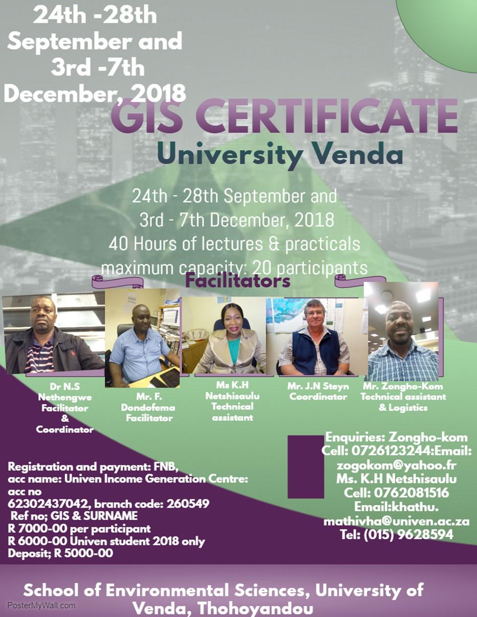
GIS certificate; 24th 28th September and 3rd 7th December University of Venda
|
|
|
- Ronald Doyle
- 5 years ago
- Views:
Transcription
1


2 ;, TARGET Delegates; Town planners. Geologist, Hydrologist, Hydro-Geologists Botanists Conservationists Land Surveyors, Educators, Researchers, Undergraduate and post-graduate students, companies, Local government authorities, Regulatory authorities, Agriculturists Health practitioners, NGOs, Crime Investigators Officers Transport Officers Environmental and Waste recycle consultants, Business Entrepreneurs GIS managers Civil Engineers Demographers Election Observers GIS Coordinators GIS project Managers IT Managers 40 Hours of lectures & practical Maximum capacity: 20 Delegates only
, a unit of Univen Income Generation Centre (UIGC).")

3 A quality driven, financially sustainable, comprehensive University The University of Venda is offering the following short course under the Univen Centre for Continuing Education (UCCE), a unit of Univen Income Generation Centre (UIGC). CERTIFICATE IN GEOGRAPHICAL INFORMATION SYSTEMS OBJECTIVES: To equip participants with knowledge and practical skills to apply Geographical Information Systems (GIS) technology to solving spatial problems, to familiarize participants with ArcGIS , the market leading GIS software package by ESRI. UP COMING SESSIONS 24th 28th September rd 7th December 2018 NB: Please, confirm booking one week before commencement of lectures to ensure a place for the intake of the course, Places are limited

4 THE COURSE The GIS Certificate Course is an introductory course to the theory and practice of a Geographic Information System. The aim of the course is to introduce students, researchers, surveyors, town planners, Local government authorities, farmers, health practitioners and NGOs to computer assisted spatial analysis and decision making. It addresses SCHEDULE The GIS Certificate Course is presented in a 5-day block training fashion. This is a competence-based course and as such candidates are expected to do Dr N.S Nethengwe both theoretical and practical exams during the last Deputy Dean: Environmental Sciences REQUIREMENTS All applicants should be proficient in a Microsoft Windows environment, and should also be familiar with applications such as Microsoft Word, Excel is helpful, but is not a prerequisite. In order to apply for the course, no formal tertiary education is re- REGISTRATION AND PAYMENT; B(Hons) UCT. Msc (Wits). PhD (West Virginia, USA) Cert (GIS) University of Southern Mississippi, USA Field of interest: Application of PGIS/PPGIS/ RS in flood Risk; Gully extraction; Modelling soil erosion, Suitability analysis Crossborder Trade & Green economy Bank: First National Bank (FNB) Enquiries: Acc Name: Univen Income Generation Centre Zongho-Kom Acc No: Cell: Branch code: zogokom@yahoo.fr Ref No; GIS & SURNAME Ms. K.H Netshisaulu R per delegate Cell: R Univen student only khathu.mathivha@univen.ac.za Deposit: R to book for a place TeL; (015) / TeL: (015) NB: Send proof of payment

5 CURRICULUM The course consists of a theoretical as well as a practical module. 40 Hours of lectures & Practical Theory: The history and philosophy of GIS The components of a GIS Data and data structures An introduction to Database Management Systems Map Projections, datum and Co-ordinate systems GIS Applications Spatial Modelling in GIS Global Positioning System Mr. Dondofema Bsc (Hons) Agriculture Animals Science, ( University of Zululand) Bsc (Hons) Applied Remote sensing and GIS (UNISA) Msc pasture Ecology IWRM (UZ) Field of interest: Application of remote sensing and GIS in Ecology, water management and agriculture Practical: (All practical work will be based on the use of ESRI ArcGIS 10) ArcGIS 10 Software Basics Data creation, editing, manipulation and display Defining Map Projections and co-ordinate systems Digitizing and inputting of GPS co-ordinates to the map Geo-referencing & Geocoding Geo-spatial Analysis and Map Production Advance GIS Analysis Operations Site Suitability Analysis Measurement, Sampling and Boundaries in GIS Light Breakfast; Coffee, Hot chocolate, Tea, And Networking over Lunch 13:00 14:00 Coffee, Tea Monday Friday
")
, M.")
")


6 PRACTICALS SESSIONS Mr. Jacobus Steyn Bsc (Hons) Wildlife management (University of Pretoria), M. Environmental Science (University of the Free State) Field of interest: Agroecology, Plant production, soil health, Rangeland and wildlife ecology management, Each delegate per computer during practical and theory lessons

 Environmental Sciences (Univen), Master Environmental Sciences (Univen) The University banking details are: NB: Maximum capacity for the first 20 delegates Field of interest:")

7 FEES The overall course fee is R 7, excluding accommodation and travel. R applies to those who are not registered with the University of Venda in this academic year, R6, applies to students who are registered with the University Venda in this academic year A deposit fee of R5, is payable upon registration. The balance is payable before or on the first day of the course. Ms K.H. Netshiasaulu Bsc (Hons) Environmental Sciences (Univen), Master Environmental Sciences (Univen) The University banking details are: NB: Maximum capacity for the first 20 delegates Field of interest: GIS & Remote sensing, Population and Demography, Cartography APPLICATION PROCEDURE Application to attend the course must reach the course co-ordinator at least two weeks prior to commencement of the course, accompanied by the full amount. Application must be made on the official enrolment form. Contact the Environmental Unit with all your enquiries regarding the course: Mr. Zongho Kom or Ms. Mathivha-Netshisaulu Environmental Unit School of Environmental Sciences Presentation: One block session. The block involves one University of Venda week of lectures and practical. Private Bag X5050 Intake: Thohoyandou and th -28th September 3rd 7th December 2018 Phone: +27(015) / (015) Cell: or zogokom@yahoo.fr or khathu.mathivha@univen.ac.za
 Environmental Management and")
 Environmental Sciences (Univen), Msc")
 LUNCH TIME Field of")


8 Network over lunch Mr. Zongho-Kom Bsc (Hons) Environmental Management and Social Sciences, University of Yaounde 1 (Cameroon), Bsc (Hons) Environmental Sciences (Univen), Msc Environmental Sciences (Univen), Cert in Logistic, Mbabane (Kingdom of Swaziland) LUNCH TIME Field of interest: Application of GIS and remote sensing/qgis / PGIS/Web GIS, Climate change, small-scale agriculture and Waste recycle Presentation: One block session. The block involves one week of lectures and practical. Intake: 24th -28th September and 3rd 7th December 2018


9 Group photo Practical examination session


10 Certificate award ceremony, 100% passed Delegates relaxing and networking during lunch


11 PAYMENT DETAILS Method of Payment: Cash: Receipt Nr: Cheque: Cheque Nr: Money Transfer: Reference
CERTIFICATE COURSE IN GEO-INFORMATICS 1 (GGFGIS7) 2016
 2016") UNIVERSITY OF JOHANNESBURG DEPARTMENT OF GEOGRAPHY, ENVIRONMENTAL MANAGEMENT AND ENERGY STUDIES CERTIFICATE COURSE IN GEO-INFORMATICS 1 (GGFGIS7) 2016 THE COURSE: The Geo-Informatics 1 course is an introduction
UNIVERSITY OF JOHANNESBURG DEPARTMENT OF GEOGRAPHY, ENVIRONMENTAL MANAGEMENT AND ENERGY STUDIES CERTIFICATE COURSE IN GEO-INFORMATICS 1 (GGFGIS7) 2016 THE COURSE: The Geo-Informatics 1 course is an introduction
Regional Centre for Mapping of Resources for Development (RCMRD), Nairobi, Kenya
, Nairobi, Kenya") Regional Centre for Mapping of Resources for Development (RCMRD), Nairobi, Kenya Introduction GIS ( 2 weeks: 10 days) Intakes: 7 th Jan, 4 th Feb,4 th March, 1 st April 6 th May, 3 rd June, 1 st July,
Regional Centre for Mapping of Resources for Development (RCMRD), Nairobi, Kenya Introduction GIS ( 2 weeks: 10 days) Intakes: 7 th Jan, 4 th Feb,4 th March, 1 st April 6 th May, 3 rd June, 1 st July,
Regional Centre for Mapping of Resources for Development (RCMRD), Nairobi, Kenya
, Nairobi, Kenya") Regional Centre for Mapping of Resources for Development (RCMRD), Nairobi, Kenya Introduction to GIS (2 weeks: 10 days) Intakes: 8 th January, 6 th February, 5th March, 3 rd. April 9 th, May 7 th, June
Regional Centre for Mapping of Resources for Development (RCMRD), Nairobi, Kenya Introduction to GIS (2 weeks: 10 days) Intakes: 8 th January, 6 th February, 5th March, 3 rd. April 9 th, May 7 th, June
Regional Centre for Mapping of Resources for Development (RCMRD), Nairobi, Kenya. Introduction GIS ( 2 weeks: 10 days)
, Nairobi, Kenya. Introduction GIS ( 2 weeks: 10 days)") Regional Centre for Mapping of Resources for Development (RCMRD), Nairobi, Kenya Introduction GIS ( 2 weeks: 10 days) Intakes: 8 th Jan, 6 th Feb,5 th March, 3 rd April 9 th, May 7 th, June 4 th, July
Regional Centre for Mapping of Resources for Development (RCMRD), Nairobi, Kenya Introduction GIS ( 2 weeks: 10 days) Intakes: 8 th Jan, 6 th Feb,5 th March, 3 rd April 9 th, May 7 th, June 4 th, July
Introduction to Coastal GIS
 Held on Tues, 1/8/13 through Thurs, 1/10/13 Location: Roger Williams University, Bristol, RI Audience: The intended audiences for this course are federal and state personnel, municipal staff and officials,
Regional Centre for Mapping of Resources for Development (RCMRD), Nairobi, Kenya. Introduction GIS (2 weeks: 10 days)
, Nairobi, Kenya. Introduction GIS (2 weeks: 10 days)") Regional Centre for Mapping of Resources for Development (RCMRD), Nairobi, Kenya Introduction GIS (: 10 days) Intake Dates: 9 th Jan, 6 th Feb, 6 th Mar, 3 rd April, 8 th May, 5 th June, 3 rd July, 2017
Regional Centre for Mapping of Resources for Development (RCMRD), Nairobi, Kenya Introduction GIS (: 10 days) Intake Dates: 9 th Jan, 6 th Feb, 6 th Mar, 3 rd April, 8 th May, 5 th June, 3 rd July, 2017
Short Term Course GEOINFORMATION SCIENCE AND TECHNOLOGY REMOTE SENSING, GPS, & GIS APPLICATIONS. Duration: 20 Weeks Two Batches in an year
 Short Term Course on GEOINFORMATION SCIENCE AND TECHNOLOGY REMOTE SENSING, GPS, & GIS APPLICATIONS Duration: 20 Weeks Two Batches in an year Information Brochure Dr. R. Satheesh Centre for Remote Sensing
Introduction to Geographic Information Systems
 Geog 58 Introduction to Geographic Information Systems, Fall, 2003 Page 1/8 Geography 58 Introduction to Geographic Information Systems Instructor: Lecture Hours: Lab Hours: X-period: Office Hours: Classroom:
MASTER OF APPLIED GEOGRAPHY (M.A.GEO.) MAJOR IN GEOGRAPHIC INFORMATION SCIENCE
 MAJOR IN GEOGRAPHIC INFORMATION SCIENCE") Master of Applied Geography (M.A.Geo.) Major in Geographic Information Science 1 MASTER OF APPLIED GEOGRAPHY (M.A.GEO.) MAJOR IN GEOGRAPHIC INFORMATION SCIENCE Major Program The Master of Applied Geography
Master of Applied Geography (M.A.Geo.) Major in Geographic Information Science 1 MASTER OF APPLIED GEOGRAPHY (M.A.GEO.) MAJOR IN GEOGRAPHIC INFORMATION SCIENCE Major Program The Master of Applied Geography
MASTER OF APPLIED GEOGRAPHY (M.A.GEO.) MAJOR IN GEOGRAPHY RESOURCE AND ENVIRONMENTAL STUDIES
 MAJOR IN GEOGRAPHY RESOURCE AND ENVIRONMENTAL STUDIES") Master of Applied Geography (M.A.Geo.) Major in Geography Resource and Environmental Studies 1 MASTER OF APPLIED GEOGRAPHY (M.A.GEO.) MAJOR IN GEOGRAPHY RESOURCE AND ENVIRONMENTAL STUDIES Major Program
Master of Applied Geography (M.A.Geo.) Major in Geography Resource and Environmental Studies 1 MASTER OF APPLIED GEOGRAPHY (M.A.GEO.) MAJOR IN GEOGRAPHY RESOURCE AND ENVIRONMENTAL STUDIES Major Program
GEOG 508 GEOGRAPHIC INFORMATION SYSTEMS I KANSAS STATE UNIVERSITY DEPARTMENT OF GEOGRAPHY FALL SEMESTER, 2002
 GEOG 508 GEOGRAPHIC INFORMATION SYSTEMS I KANSAS STATE UNIVERSITY DEPARTMENT OF GEOGRAPHY FALL SEMESTER, 2002 Course Reference #: 13210 Meeting Time: TU 2:05pm - 3:20 pm Meeting Place: Ackert 221 Remote
GRADUATE CERTIFICATE PROGRAM
 GRADUATE CERTIFICATE PROGRAM GEOGRAPHIC INFORMATION SCIENCES Department of Geography University of North Carolina Chapel Hill Conghe Song, Director csong @email.unc.edu 919-843-4764 (voice) 919-962-1537
ENVIRONMENT AND NATURAL RESOURCES 3700 Introduction to Spatial Information for Environment and Natural Resources. (2 Credit Hours) Semester Syllabus
 Semester Syllabus") ENVIRONMENT AND NATURAL RESOURCES 3700 Introduction to Spatial Information for Environment and Natural Resources COURSE INSTRUCTOR: Dr. Kris Jaeger Assistant Professor 359 Kottman Hall (Mondays and Tuesdays)
ENVIRONMENT AND NATURAL RESOURCES 3700 Introduction to Spatial Information for Environment and Natural Resources COURSE INSTRUCTOR: Dr. Kris Jaeger Assistant Professor 359 Kottman Hall (Mondays and Tuesdays)
CAREER ORIENTED KITCO
 CAREER ORIENTED TRAINING @ KITCO If you are at the cross roads of your career life or facing challenges at work which you find difficult to overcome, picking up a new skill or enhancing your capability
Introduction to GIS (GEOG 401) Spring 2014, 3 credit hours
 Spring 2014, 3 credit hours") Introduction to GIS (GEOG 401) Spring 2014, 3 credit hours Instructors: Guangxing Wang, Ph.D. Email: gxwang@siu.edu Phone: (618) 453-6017 Office: 4442 Faner Hall Office hours: M& W&F 9:00am-11:00am or
Introduction to GIS (GEOG 401) Spring 2014, 3 credit hours Instructors: Guangxing Wang, Ph.D. Email: gxwang@siu.edu Phone: (618) 453-6017 Office: 4442 Faner Hall Office hours: M& W&F 9:00am-11:00am or
PLANNING (PLAN) Planning (PLAN) 1
 Planning (PLAN) 1") Planning (PLAN) 1 PLANNING (PLAN) PLAN 500. Economics for Public Affairs Description: An introduction to basic economic concepts and their application to public affairs and urban planning. Note: Cross-listed
Planning (PLAN) 1 PLANNING (PLAN) PLAN 500. Economics for Public Affairs Description: An introduction to basic economic concepts and their application to public affairs and urban planning. Note: Cross-listed
REGULATIONS FOR THE POSTGRADUATE DIPLOMA IN GEOGRAPHIC INFORMATION SYSTEMS (PDipGIS)
") 182 REGULATIONS FOR THE POSTGRADUATE DIPLOMA IN GEOGRAPHIC INFORMATION SYSTEMS (PDipGIS) (See also General Regulations) PDGIS 1 Admission requirements To be eligible for admission to studies leading to
182 REGULATIONS FOR THE POSTGRADUATE DIPLOMA IN GEOGRAPHIC INFORMATION SYSTEMS (PDipGIS) (See also General Regulations) PDGIS 1 Admission requirements To be eligible for admission to studies leading to
A Level Geography Cambridge International Content Programme For teaching from September 2016
 A Level Geography Cambridge International Content Programme For teaching from September 2016 is located on the Start Bay coast in South Devon and is surrounded by Slapton Ley National Nature Reserve. The
Dr. Stephen J. Walsh Department of Geography, UNC-CH Fall, 2007 Monday 3:30-6:00 pm Saunders Hall Room 220. Introduction
 Geographic Information Systems Geography 491 Dr. Stephen J. Walsh Department of Geography, UNC-CH Fall, 2007 Monday 3:30-6:00 pm Saunders Hall Room 220 Introduction Organizations that have a planning,
No. of Days. Building 3D cities Using Esri City Engine ,859. Creating & Analyzing Surfaces Using ArcGIS Spatial Analyst 1 7 3,139
 Q3 What s New? Creating and Editing Data with ArcGIS Pro Editing and Maintaining Parcels Using ArcGIS Spatial Analysis Using ArcGIS Pro User Workflows for ArcGIS Online Organizations Q3-2018 ArcGIS Desktop
THE NEW CHALLENGES FOR THE HIGHER EDUCATION OF GEODESY IN UACEG SOFIA
 THE NEW CHALLENGES FOR THE HIGHER EDUCATION OF GEODESY IN UACEG SOFIA Ivan Kunchev University of Architecture, Civil Engineering and Geodesy, 1 Hristo Smirnenski Blvd., Sofia 1046, Bulgaria Abstract Report
Request for Empanelment
 Request for Empanelment (Empanelment is method/procedure/way to seek technical & financial or financial quotation from eligible firm/organization/academic institute to short list eligible contender for
CURRICULUM VITAE Mthobeli Vaaltyn
 CURRICULUM VITAE Mthobeli Vaaltyn 2880 Dwarhane Street Browns Farm Philippi 7785 Cell: 071 3720 456 E-Mail: mvaaltyn4@gmail.com PERSONAL DETAILS Surname First Name(s) : Vaaltyn : Mthobeli Date of Birth
Geographic Systems and Analysis
 Geographic Systems and Analysis New York University Robert F. Wagner Graduate School of Public Service Instructor Stephanie Rosoff Contact: stephanie.rosoff@nyu.edu Office hours: Mondays by appointment
Cartographic Workshop
 http://lazarus.elte.hu/cet/ Cartographic Workshop One of the roles of the ICA, Commission on Education and Training is to provide member nations with cartographic workshop experiences that enhance the
Programme Study Plan
 Faculty of Social and Life Sciences Programme Study Plan Geographic Information Systems Programme Code: Programme Title: TGLIT Engineering: Surveying Technology and Geographical IT Credits: 180 Programme
Lab Assistant: Kathy Tang Office: SSC 2208 Phone: ext
 The University of Western Ontario Department of Geography GEOGRAPHY 9110B: Introduction to Geographic Information Systems Lecture: Thursday 11:30 1:30pm, SSC #1004 Lab: Thursday 2:30 4:30pm, SSC #1316A
Spatial Data Analysis with ArcGIS Desktop: From Basic to Advance
 Spatial Data Analysis with ArcGIS Desktop: From Basic to Advance 1. Course overview Modern environmental, energy as well as resource modeling and planning require huge amount of geographically located
DIPLOMA IN GEOMATICS (NQF Level 6)
") DIPLOMA IN GEOMATICS ( 6) Programme Aims/Purpose: The Diploma in Geomatics programme was purposefully designed to prepare students for a career as survey technician, with specialised knowledge and skills
DIPLOMA IN GEOMATICS ( 6) Programme Aims/Purpose: The Diploma in Geomatics programme was purposefully designed to prepare students for a career as survey technician, with specialised knowledge and skills
Techniques for Science Teachers: Using GIS in Science Classrooms.
 Techniques for Science Teachers: Using GIS in Science Classrooms. After ESRI, 2008 GIS A Geographic Information System A collection of computer hardware, software, and geographic data used together for
Advancing Green Chemistry Practices in Business
 Green Chemistry and Commerce Council: 6 th Annual GC3 Innovators Roundtable Advancing Green Chemistry Practices in Business Barbara Peterson, Ph.D. Marty Mulvihill, Ph.D. Program Director Executive Director,
Footprint Ecology Training 2016
 Footprint Ecology B USINESS NAME Training 2016 Footprint Ecology is an independent ecology consultancy based in Dorset. Our work focuses on nature conservation and in particular: recreation and wildlife
BA Humanities (code , duration of study is 3 year)
") BA Humanities (Code 01130015) (Faculty of Humanities) Total credits: 366 Undergraduate enquiries: Dr Nerhene Davis, nerhene.davis@up.ac.za UNDERGRADUATE STUDY PROGRAMME If you are interested in Geography
BA Humanities (Code 01130015) (Faculty of Humanities) Total credits: 366 Undergraduate enquiries: Dr Nerhene Davis, nerhene.davis@up.ac.za UNDERGRADUATE STUDY PROGRAMME If you are interested in Geography
HGP 470 GIS and Advanced Cartography for Social Science
 HGP 470 GIS and Advanced Cartography for Social Science Winter 2014 Instructor: Office: Tory 3-115 Telephone: 780-248-5758 E-mail: vukicevi@ualberta.ca Office hours: By appointment LECTURES AND LABS Lectures/Labs:
International Development
 International Development Office: The Payson Center for International Development and Technology Transfer, 300 Hébert Hall Phone: 504-865-5240 Fax: 504-865-5241 Website: www.payson.tulane.edu/ Program
Diffusion of GIS in Public Policy Doctoral Program
 Diffusion of GIS in Public Policy Doctoral Program By Fulbert Namwamba PhD Southern University This presentation demonstrate how GIS was introduced in the Public Policy Doctoral Program at Southern University,
Stratigraphy. Sequence, Seismic & Integrated Stratigraphic Analysis
 An Intensive 5 Day Training Course Stratigraphy Sequence, Seismic & Integrated Stratigraphic Analysis 11-15 Nov 2018, Dubai 09-OCT-17 This course is Designed, Developed, and will be Delivered under iso
No. of Days. ArcGIS 3: Performing Analysis ,431. Building 3D cities Using Esri City Engine ,859
 What s New? Creating Story Maps with ArcGIS Field Data Collection and Management Using ArcGIS Get Started with Insights for ArcGIS Introduction to GIS Using ArcGIS & ArcGIS Pro: Essential Workflow Migrating
No. of Days. ArcGIS Pro for GIS Professionals ,431. Building 3D cities Using Esri City Engine ,859
 What s New? Creating Story Maps with ArcGIS Field Data Collection and Management Using ArcGIS Get Started with Insights for ArcGIS Introduction to GIS Using ArcGIS & ArcGIS Pro: Essential Workflow Migrating
GIS based modeling of chemical fate, transport and impacts for policy support
 GENERAL INFORMATION Chemical risk communication and management increasingly requires mapping of exposure and vulnerability. Maps are often ideal tools both from the perspective of public decision makers,
WHAT YOU WILL LEARN TODAY
 WHAT YOU WILL LEARN TODAY Overview of the new QGIS Academy Curriculum Background on curriculum development Curriculum alignment with national standards Description of the five GIS courses Details of the
1. Omit Human and Physical Geography electives (6 credits) 2. Add GEOG 677:Internet GIS (3 credits) 3. Add 3 credits to GEOG 797: Final Project
 2. Add GEOG 677:Internet GIS (3 credits) 3. Add 3 credits to GEOG 797: Final Project") The Department of Geography and the Office of Professional Studies propose to modify the Master of Professional Studies in Geospatial Information Sciences (GIS) as follows: 1. Omit Human and Physical Geography
The Department of Geography and the Office of Professional Studies propose to modify the Master of Professional Studies in Geospatial Information Sciences (GIS) as follows: 1. Omit Human and Physical Geography
6 February 2018, Subject: FME World Tour 2018 At Sunway Resort Hotel & Spa
 6 February 2018, Subject: FME World Tour 2018 At Sunway Resort Hotel & Spa FME technology has evolved from the ETL (Extract Transform Load) software to the multi tool for connecting, transforming and automating
GIS = Geographic Information Systems;
 What is GIS GIS = Geographic Information Systems; What Information are we talking about? Information about anything that has a place (e.g. locations of features, address of people) on Earth s surface,
Introduction to Coastal GIS
 Introduction to Coastal GIS Event was held on Tues, 1/8/13 - Thurs, 1/10/13 Time: 9:00 am to 5:00 pm Location: Roger Williams University, Bristol, RI Audience: The intended audiences for this course are
Geography (GEOG) Courses
 Courses") Geography (GEOG) 1 Geography (GEOG) Courses GEOG 100. Introduction to Human Geography. 4 (GE=D4) Introduction to the global patterns and dynamics of such human activities as population growth and movements,
Geography (GEOG) 1 Geography (GEOG) Courses GEOG 100. Introduction to Human Geography. 4 (GE=D4) Introduction to the global patterns and dynamics of such human activities as population growth and movements,
Advanced Readings. Environment and Land Use Concentration The following seminars and studios would apply
 Community Development and Housing Concentration URP 720 Urban Housing Policies URP 722 Community Development and Housing URP 724 Urban Revitalization Studio URP 726 Citizen Participation Strategies URP
SYLLABUS SEFS 540 / ESRM 490 B Optimization Techniques for Natural Resources Spring 2017
 SYLLABUS SEFS 540 / ESRM 490 B Optimization Techniques for Natural Resources Spring 2017 Lectures: Winkenwerder Hall 107, 4:50-5:50pm, MW Labs: Mary Gates Hall 030, 1:30-2:50pm, Th Course Web Site: http://faculty.washington.edu/toths/course.shtml
REVIEW MAPWORK EXAM QUESTIONS 31 JULY 2014
 REVIEW MAPWORK EXAM QUESTIONS 31 JULY 2014 Lesson Description In this lesson we: Focus on key concepts and exam questions relating to GIS. Question 1 Test Yourself The most important component of a GIS
Geog418: Introduction to GIS Fall 2011 Course Syllabus. Textbook: Introduction to Geographic Information Systems edited by Chang (6th ed.
 Geog418: Introduction to GIS Fall 2011 Course Syllabus AH 1320 3:30 4:45 p.m.tr Instructor: Dr. Shunfu Hu Office: AH1413 Telephone 650-2281 Office hours: 10:00 11:00 a.m. TR or by appointment (shu@siue.edu)
Complete version as of 1 October 2017
 Note: The legally binding versions are found in the University of Innsbruck Bulletins (in German). Appendix to the University of Innsbruck Bulletin of 3 June 2015, Issue 60, No. 457 Original version published
Different Models of the Curriculum for the Higher Education of Surveying & Mapping in China
 Different Models of the Curriculum for the Higher Education of Surveying & Mapping in China NING Jinsheng, LIU Yanfang, LIU Yaolin, China P. R. Key words: curriculum, common foundation, distinguished feature
https://sites.google.com/a/pdx.edu/gis-2-applications/home
 Page 1 of 5 GIS 2: APPLICATIONS Search this site GEOG 492/592: GIS 2 Syllabus Academic Guidelines Rubrics Presentation Rubric Project Poster Project Proposal Syllabus (PDF) Sitemap GEOG 492/592: GIS 2
GIST 4302/5302: Spatial Analysis and Modeling Lecture 1: Overview
 GIST 4302/5302: Spatial Analysis and Modeling Lecture 1: Overview Guofeng Cao www.myweb.ttu.edu/gucao Department of Geosciences Texas Tech University guofeng.cao@ttu.edu Fall 2017 Texas Tech GIS Graduate
GIScience in Urban Planning Education - Experience from University of Maryland
 GIScience in Urban Planning Education - Experience from University of Maryland February 3, 2007 University of Tokyo Qing Shen Professor of Urban Studies and Planning School of Architecture,
Proposal for Revision to the Geographic Information Systems (GIS) Academic Certificate Community College of Philadelphia.
 Academic Certificate Community College of Philadelphia.") Proposal for Revision to the Geographic Information Systems (GIS) Academic Certificate Community College of Philadelphia February 24, 2010 Kathy Smith Chair, Social Science Contributors Christopher Murphy
Proposal for Revision to the Geographic Information Systems (GIS) Academic Certificate Community College of Philadelphia February 24, 2010 Kathy Smith Chair, Social Science Contributors Christopher Murphy
Emerging Issues in Geographic Information Science (GEP680): Projections, Scale, Accuracy, and Interpolation Lehman College, Spring 2017
: Projections, Scale, Accuracy, and Interpolation Lehman College, Spring 2017") Emerging Issues in Geographic Information Science (GEP680): Projections, Scale, Accuracy, and Interpolation Lehman College, Spring 2017 Instructor: Gary Ostroff, P.E., Adjunct Lecturer E-mail: Gary.Ostroff@lehman.cuny.edu;
Emerging Issues in Geographic Information Science (GEP680): Projections, Scale, Accuracy, and Interpolation Lehman College, Spring 2017 Instructor: Gary Ostroff, P.E., Adjunct Lecturer E-mail: Gary.Ostroff@lehman.cuny.edu;
Syllabus Reminders. Geographic Information Systems. Components of GIS. Lecture 1 Outline. Lecture 1 Introduction to Geographic Information Systems
 Syllabus Reminders Geographic Information s Lecture Introduction to Geographic Information s. Class Info: www.saigis.com/class/ 2. Office T / TH (8:00-9:30 a.m.) and (2:30 3:30pm) or Appt 3. Email: burgerpr@unk.edu
COURSE SCHEDULE, GRADING, and READINGS
 COURSE SCHEDULE, GRADING, and READINGS Note: All academic classes will be held in the GIS lab at Royal Thimphu College. These dates are listed here. Other days will involve travel or days off, and the
A career in Geoinformatics
 A career in Geoinformatics presented by Serena Coetzee Centre for Geoinformation Science www.up.ac.za/cgis Department of Geography, Geoinformatics and Meteorology Mamelodi campus, 6 September 2011 University
WHAT YOU WILL LEARN TODAY
 WHAT YOU WILL LEARN TODAY Overview of the new GeoAcademy Curriculum Background on curriculum development Curriculum alignment with national standards Description of the five GIS courses Details of the
The B.S.G.E. program is accredited by the Engineering Accreditation Commission of ABET,
 Geomatics Engineering The program of study leading to the Bachelor of Science in Geomatics Engineering (B.S.G.E.) deals with designing solutions to measure, map, model, analyze and graphically display
Surface chemistry. Surfactants and Polymers in Aqueous Solution. of Surfactants and Polymers. 5-9 October 2015 in Lisbon, Portugal
 Bengt Kronberg Krister Holmberg Björn Lindman Surface chemistry Surfactants and Polymers in Aqueous Solution Based on the new book Surface Chemistry of Surfactants and Polymers 5-9 October 2015 in Lisbon,
CAP 437 Offshore Meteorological Observer Training
 CAP 437 Offshore Meteorological Observer Training Training for Meteorological Observers in support of Offshore Helicopter Operations CAP 437 Offshore Meteorological Observer Training Page 1 Meteorological
Teaching GIS Technology at UW-Superior. Volume 9, Number 8: May 23, 2003
 Teaching GIS Technology at UW-Superior Volume 9, Number 8: May 23, 2003 William Bajjali University of Wisconsin, department of Biology and Earth Science, Superior, WI 54880 Abstract As educators, it is
AGRY 545/ASM 591R. Remote Sensing of Land Resources. Fall Semester Course Syllabus
 AGRY 545/ASM 591R Remote Sensing of Land Resources Fall Semester 2005 Course Syllabus Agronomy 545/ASM 591R is a graduate level course designed to teach students how to analyze and interpret remotely sensed
EEOS 465 / 627 Environmental Modeling with Raster GIS. David Tenenbaum EEOS 465 / 627 UMass Boston
 EEOS 465 / 627 Environmental Modeling with Raster GIS EEOS 465 / 627 Environmental Modeling with Raster GIS Course Description: This course consists of three parts: In the first four weeks, we will focus
BACHELOR OF GEOINFORMATION TECHNOLOGY (NQF Level 7) Programme Aims/Purpose:
 Programme Aims/Purpose:") BACHELOR OF GEOINFORMATION TECHNOLOGY ( Level 7) Programme Aims/Purpose: The Bachelor of Geoinformation Technology aims to provide a skilful and competent labour force for the growing Systems (GIS) industry
BACHELOR OF GEOINFORMATION TECHNOLOGY ( Level 7) Programme Aims/Purpose: The Bachelor of Geoinformation Technology aims to provide a skilful and competent labour force for the growing Systems (GIS) industry
UNITED NATIONS E/CONF.96/CRP. 5
 UNITED NATIONS E/CONF.96/CRP. 5 ECONOMIC AND SOCIAL COUNCIL Eighth United Nations Regional Cartographic Conference for the Americas New York, 27 June -1 July 2005 Item 5 of the provisional agenda* COUNTRY
What can I do with a major in Earth Information Science?
 Lewis-Clark State College offers a Bachelor of Arts or Science Degree in Earth Information Science through the Natural Sciences and Mathematics Division. You can learn more about the Natural Sciences and
IMPROVING MIXING PROCESSES FOR INDUSTRIAL APPLICATIONS
 Short Course IMPROVING MIXING PROCESSES FOR INDUSTRIAL APPLICATIONS Cranfield, Bedfordshire, UK: 25 27 November 2008 BHRG roup TheFluidEngineeringCentre Ideal for: Experienced engineers and scientists
Spatial Analysis and Modeling (GIST 4302/5302) Guofeng Cao Department of Geosciences Texas Tech University
 Guofeng Cao Department of Geosciences Texas Tech University") Spatial Analysis and Modeling (GIST 4302/5302) Guofeng Cao Department of Geosciences Texas Tech University TTU Graduate Certificate Geographic Information Science and Technology (GIST) 3 Core Courses and
Spatial Analysis and Modeling (GIST 4302/5302) Guofeng Cao Department of Geosciences Texas Tech University TTU Graduate Certificate Geographic Information Science and Technology (GIST) 3 Core Courses and
Page 1 of 6 Target Exploration Consultants Ltd. is a United Kingdom registered company no
 26-27 November 2018 at Al-Nawras Hotel, Dubai, UAE Instructor: Dr. Mohammed Warrak, PhD. Target Exploration Consultants, London, UK. www.targetexploration.com Page 1 of 6 Target Exploration Consultants
Esri India User Conference
 Esri India User Conference The Leela Ambience Convention Hotel, Delhi January 19 20, 2017 Keynote Speaker Jack Dangermond Founder and President, Esri Inc. Register Today esriindia.com/indiauc About Esri
Open Source Software Education in Texas
 Open Source Software Education in Texas PHILLIP DAVIS / RICHARD SMITH GEOACADEMY The Challenge for Open Source Adoption OPEN SOURCE Less the 5% of US colleges and universities offer training in Free and
CENSUS MAPPING WITH GIS IN NAMIBIA. BY Mrs. Ottilie Mwazi Central Bureau of Statistics Tel: October 2007
 CENSUS MAPPING WITH GIS IN NAMIBIA BY Mrs. Ottilie Mwazi Central Bureau of Statistics E-mail: omwazi@npc.gov.na Tel: + 264 61 283 4060 October 2007 Content of Presentation HISTORICAL BACKGROUND OF CENSUS
Module Name Module Code
 Module Name Module Code Digital Spatial Analysis - Practical Exercises AEF-EM013 Module Coordinator Dr. agr. Georg Hörmann Organizer Institute for Natural Resource Conservation - Hydrology and Water Resources
Esri and GIS Education
 Esri and GIS Education Organizations Esri Users 1,200 National Government Agencies 11,500 States & Regional Agencies 30,800 Cities & Local Governments 32,000 Businesses 8,500 Utilities 12,600 NGOs 11,000
Mapping Secondary Cities for Resiliency and Emergency Preparedness
 Mapping Secondary Cities for Resiliency and Emergency Preparedness Secondary Cities Geospatial Training Workshop Pilot Project: Cusco, Peru June 29 July 3 2015 WHO ARE WE? Office of the Geographer (GGI)
BSc (Hons) Chemistry (Optional Minor: Forensic Science)/MSc Chemistry SC521
 Chemistry (Optional Minor: Forensic Science)/MSc Chemistry SC521") BSc (Hons) Chemistry (Optional Minor: Forensic Science)/MSc Chemistry SC521 1. Mission, Aims and Objectives Chemistry is considered as the "central" science because it involves all of the other sciences.
BSc (Hons) Chemistry (Optional Minor: Forensic Science)/MSc Chemistry SC521 1. Mission, Aims and Objectives Chemistry is considered as the "central" science because it involves all of the other sciences.
Grade 11 Student Electives Guidelines for 2015/16
 Grade 11 Student Guidelines for 2015/16 Overview As part of Abu Dhabi Education Council s continuous improvements efforts towards raising the standard of education in the Emirate of Abu Dhabi, the Cycle
Geography. 316 Geography
 316 Geography Geography Degrees Associate in Arts Degree: Geography Associate in Arts Degree (AA-T): Geography for Transfer Program Description Geography is the science of space and place. Geographers
ENV208/ENV508 Applied GIS. Week 1: What is GIS?
 ENV208/ENV508 Applied GIS Week 1: What is GIS? 1 WHAT IS GIS? A GIS integrates hardware, software, and data for capturing, managing, analyzing, and displaying all forms of geographically referenced information.
Understanding China Census Data with GIS By Shuming Bao and Susan Haynie China Data Center, University of Michigan
 Understanding China Census Data with GIS By Shuming Bao and Susan Haynie China Data Center, University of Michigan The Census data for China provides comprehensive demographic and business information
Curriculum Vitae. Dr. Danqing (Dana) Xiao. Ph.D. in Department of Geography, University of California Santa Barbara.
 Xiao. Ph.D. in Department of Geography, University of California Santa Barbara.") Curriculum Vitae Dr. Danqing (Dana) Xiao Personal Information Assistant Professor Department of Environmental, Geographical, and Geological Sciences (EGGS), Bloomsburg University of Pennsylvania Research
Curriculum Vitae Dr. Danqing (Dana) Xiao Personal Information Assistant Professor Department of Environmental, Geographical, and Geological Sciences (EGGS), Bloomsburg University of Pennsylvania Research
Geographic Information for Economic and Spatial Decisions
 !"#$!%& ''"(')* +"&'",, *+""-./0 Geographic Information for Economic and Spatial Decisions Objectives The master is aimed at creating skilled professionals in Geographic Information, qualified to work
Creating a Staff Development Plan with Esri
 Creating a Staff Development Plan with Esri Michael Green David Schneider Guest Presenter: Shane Feirer, University of California Esri UC 2014 Technical Workshop Agenda What is a Staff Development Plan?
John Laznik 273 Delaplane Ave Newark, DE (302)
") Office Address: John Laznik 273 Delaplane Ave Newark, DE 19711 (302) 831-0479 Center for Applied Demography and Survey Research College of Human Services, Education and Public Policy University of Delaware
Office Address: John Laznik 273 Delaplane Ave Newark, DE 19711 (302) 831-0479 Center for Applied Demography and Survey Research College of Human Services, Education and Public Policy University of Delaware
(Agensi di bawah KPDNHEP) INTRODUCTION TO MBRS MBRS FOR PREPARERS FINANCIAL STATEMENTS
 INTRODUCTION TO MBRS MBRS FOR PREPARERS FINANCIAL STATEMENTS") (Agensi di bawah KPDNHEP) INTRODUCTION TO MBRS MBRS FOR PREPARERS FINANCIAL STATEMENTS INTRODUCTION TO MBRS COURSE INTRODUCTION On 27 September 2018, the Suruhanjaya Syarikat Malaysia (SSM) launched the
(Agensi di bawah KPDNHEP) INTRODUCTION TO MBRS MBRS FOR PREPARERS FINANCIAL STATEMENTS INTRODUCTION TO MBRS COURSE INTRODUCTION On 27 September 2018, the Suruhanjaya Syarikat Malaysia (SSM) launched the
CAWa Central Asian Water. Training Course Geographical Information Systems in Hydrology
 CAWa Central Asian Water Training Course Geographical Information Systems in Hydrology 1 Place & Time Place to hold the workshop: Helmholtz Centre Potsdam GFZ German Research Center for Geosciences, Germany
CAS GE 365 Introduction to Geographical Information Systems. The Applications of GIS are endless
 Spring 2007 CAS GE 365 Introduction to Geographical Information Systems Boston University Department of Geography and Environment The Applications of GIS are endless images from www.esri.com CAS GE 365
USP/PLSI 493: Methods of Planning Data Analysis (4 credits) San Francisco State University Spring 2011
 San Francisco State University Spring 2011") USP/PLSI 493: Methods of Planning Data Analysis (4 credits) Department of Urban Studies and Planning Professor Ayse Pamuk San Francisco State University Spring 2011 Mondays and Wednesdays 10:10-11:50pm
USP/PLSI 493: Methods of Planning Data Analysis (4 credits) Department of Urban Studies and Planning Professor Ayse Pamuk San Francisco State University Spring 2011 Mondays and Wednesdays 10:10-11:50pm
BUDGET/FINANCIAL REPORT
 BUDGET/FINANCIAL REPORT Name of the Project Business Start-Up Centre Activity Number QE 13351 - BSC Reporting Period oct 2006 - mar 2007 The other Party Academic Training Association Currency Euro Total
MRD 228 METADATA. Official Name of the Data Set or Information Holding: Physiography of Southern Ontario
 MRD 228 METADATA GENERAL INFORMATION Official Name of the Data Set or Information Holding: Physiography of Southern Ontario Acronyms are Used to Identify the Data Set or Information Holding: MRD228 Describe
(Agensi di bawah KPDNHEP) INTRODUCTION TO MBRS MBRS FOR PREPARERS FINANCIAL STATEMENTS
 INTRODUCTION TO MBRS MBRS FOR PREPARERS FINANCIAL STATEMENTS") (Agensi di bawah KPDNHEP) INTRODUCTION TO MBRS MBRS FOR PREPARERS FINANCIAL STATEMENTS INTRODUCTION TO MBRS COURSE INTRODUCTION COURSE CONTENTS On 27 September 2018, the Suruhanjaya Syarikat Malaysia (SSM)
(Agensi di bawah KPDNHEP) INTRODUCTION TO MBRS MBRS FOR PREPARERS FINANCIAL STATEMENTS INTRODUCTION TO MBRS COURSE INTRODUCTION COURSE CONTENTS On 27 September 2018, the Suruhanjaya Syarikat Malaysia (SSM)
TEACHING ASSISTANT POSITIONS (CUPE 3902, Unit 1) Fall/Winter Department of Geography, University of Toronto Mississauga
 Fall/Winter Department of Geography, University of Toronto Mississauga") TEACHING ASSISTANT POSITIONS (CUPE 3902, Unit 1) Fall/Winter -2019 Department of Geography, University of Toronto Mississauga Posted on: June 13, Applications due: July 5 th, # of ENV100Y5Y The Environment
TEACHING ASSISTANT POSITIONS (CUPE 3902, Unit 1) Fall/Winter -2019 Department of Geography, University of Toronto Mississauga Posted on: June 13, Applications due: July 5 th, # of ENV100Y5Y The Environment
GEOG People and their Environment Section 01 Spring 2015 Monday and Thursday 1:10 pm to 2:25 pm Hunter West 511
 GEOG. 101- People and their Environment Section 01 Spring 2015 Monday and Thursday 1:10 pm to 2:25 pm Hunter West 511 Dr Mohamed B. Ibrahim Office: Hunter North 1048 Tel. 772-5267 mibrahim@hunter.cuny.edu
Agricultural. Chemistry. Agricultural production: crops and livestock Agrichemicals development: herbicides, pesticides, fungicides, fertilizers, etc.
 Agricultural Agricultural production: crops and livestock Agrichemicals development: herbicides, pesticides, fungicides, fertilizers, etc. Agrichemicals testing Environmental testing Regulation Government:
INTERNATIONAL TRAINING COURSE ON THE APPLICATION OF METEOROLOGICAL SATELLITE PRODUCTS 20 June to 1 July 2016, Beijing, China ENROLMENT INFORMATION
 ETR/CRS-316, ANNEX 1 INTERNATIONAL TRAINING COURSE ON THE APPLICATION OF METEOROLOGICAL SATELLITE PRODUCTS 20 June to 1 July 2016, Beijing, China ENROLMENT INFORMATION The International Training Course
Application of Geospatial Technology in an Emergency Management Academic Program
 Application of Geospatial Technology in an Emergency Management Academic Program Author Edwin Leachman Visiting Assistant Professor Department of Emergency Administration and Management Arkansas Tech University