Key Concepts: perspective representations/accounts spatial scales
|
|
|
- Annis Short
- 5 years ago
- Views:
Transcription
1 Unit 1 Lesson 2 6 G1.1.1 Describe how geographers use mapping to represent places and natural and human phenomena in the world. 7 H1.2.3 Identify the point of view (perspective of the author) and context when reading and discussing primary and secondary sources. 7 G1.2.2 Explain why maps of the same place may vary as a result of the cultural or historical background of the cartographer. WHST Write routinely over extended time frames (time for reflection and revision) and shorter time frames (a single sitting or a day or two) for a range of discipline-specific tasks, purposes, and audiences.
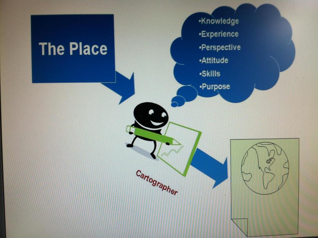
2 Lesson Abstract: In this lesson, students revisit the different projections cartographers have devised to address the problem of representing a threedimensional object in a two-dimensional medium. Next, they consider three ancient maps of the same place and compare them. Students learn that just as their own maps of the school differed, these cartographers created different maps of the same place. Students explore how knowledge, purpose, and perspective shape how people create accounts or representations of a place. Key Concepts: perspective representations/accounts spatial scales
3 What Can A Map Tell Us? Big Ideas of the Lesson: Maps are representations of places. A map is NOT the place. One difficulty with maps is that they try to represent a three dimensional object in a two dimensional plane. People who create maps select and organize the features of the place to include in their maps. People s purposes, knowledge, and perspective (or point of view) shape their maps. Maps of the ancient world reflect the cartographer s purposes, knowledge, and perspective (or point of view)

4
5
6 What Can A Map Tell Us? Learning Targets: I can conclude that maps are representations of places. A map is NOT the place. I can relate that one difficulty with maps is that they try to represent a three dimensional object in a two dimensional plane. I can explain that people who create maps select and organize the features of the place to include in their maps. I can support that people s purposes, knowledge, and perspective (or point of view) shape their maps. I can conclude that maps of the ancient world reflect the cartographer s purposes, knowledge, and perspective (or point of view).

7
8 What Can A Map Tell Us? #1 Think about your BALLOON PROJECT and what happened. Over time people have addressed this problem in different ways. The next group of slides will show you Different Representations of the Earth. Remember that they depicted the earth a little differently in an attempt to solve the problem of representing a three-dimensional object on a twodimensional plane
9 First: What is a map projection? Map projections are an important aspect of ALL maps---all maps require the transformation of a spherical earth into a flat surface The map projection process ALWAYS introduces some kind of distortion. Distortion of area, shape, angles, etc. Maps that are accurate in portraying relative SIZE, distort SHAPE. Maps that are accurate in portraying SHAPE, distort relative SIZE.

10 Mercator Projection

11

12 Goode Projections Size of Land is accurate

13 Winkel Tripel Projections Show the roundness of the earth

14

15 Mercator (1569 CE) Identify the distortions.
16 Mercator Projection Purpose: For navigation Shapes ok, relative size distorted, especially away from equator Indicates true North/South/East/West: true compass bearings Greenland appears larger than Africa, but is actually 14X smaller Alaska is bigger than Mexico South America smaller the Europe Equator is 2/3 of the way down, poles not shown, Europe in center Default for MapQuest, Google Maps, Yahoo Maps Still displayed in many classrooms
17 Map Questions: Mercator Projection: Is Alaska is bigger than Mexico? Actually, Mexico is bigger than Alaska by 254,696 square kilometers (98,338 sq mi), which equals the size of Oregon. *Alaska: 1,717,854 square kilometers (663,268 sq mi) *Mexico: 1,972,550 square kilometers (761,606 sq mi) Is South America smaller the Europe? What continents are smaller than the continent South America? *South America is 17,840,000 sq km *Antarctica - about 14,000,000 sq km *Australia - 7,686,850 sq km *Europe - 9,940,000 sq km

18 Robinson (1963 CE) Identify the distortions.
19 Robinson Projection (1963 CE) Makes the world look right --better balance of size and shape than Mercator Russia, Canada and Greenland truer to size Distortion greatest near the poles and low distortion at equator National Geographic adopted this projection in 1988 (replaced in 1998 by Winkel Tripel, a 1921 projection). May replace Mercator in many places, like classrooms
 Identify the")
20 Peters Projection (1973 CE) Identify the distortions.
21 Peters Projection (1973 CE) Relative size accurate, but shapes are distorted. Political argument being made in response to Mercator: Mercator inflates the size of regions as they gain distance from the equator. Since much of the developing world lies near the equator, these countries appear smaller and less significant. Peters restores the size of poorer, less powerful nations....the Mercator projection overvalues the white man and distorts the picture of the world to the advantage of the colonial masters of the time. Dr. Arno Peters, 1974 news conference


22 Can you guess where the map maker was from? (1979)

23 McArthur Map Created by Stuart McArthur of Melbourne, Australia. He drew his first South-Up map when he was 12 years old (1970). His geography teacher told him to re-do his assignment with the "correct" way up if he wanted to pass. Three years later he was an exchange student in Japan. He was taunted by his exchange studentfriends from the USA for coming from "the bottom of the world." It was then, at age 15, he resolved to one day publish a map with Australia at the top. Six years later, while at Melbourne University, he produced the world's first "modern south up map and launched it on Australia day in It has sold over 350,000 copies to date.

24 Finally: How might new knowledge, based on science and modern technology, influence how maps look?


25 Question...stop & jot In what ways do maps TALK to you? Reflect on what you learned or already knew about maps.

26 Lesson 2: Ancient Map Activity Goal: to allow students to think through and see examples of how a map reflects a cartographer s: knowledge purpose perspective However, this is NOT about the individual cartographers. The larger point is about maps as accounts, not events.
27 Ancient Maps You will receive a classroom copy: Treat these papers gently DO NOT WRITE ON THEM Turn them in when directed to do so I only have one copy for each student in a class
28 What does the map tell you about the mapmaker and his/her times? With a partner use these questions to help you as you think of your own ideas (~10 15 min.) Record your thoughts in your SS Notebook: 1. What shapes do you recognize on the map? What shapes seem incomplete or unusual? Anything missing? What does that suggest? 2. What does the map suggest about the knowledge of the people who made the map? 3. Does the map offer any clues about where the person lived? Does the map show a point-of-view or perspective? 4. Look at the date of the map. Does the time frame support your analysis? (Hint: The bigger the # = older) 5. How does this view of the world compare to the other ancient maps? 6. Be prepared for class discussion
29 Ancient Maps #2 Investigate the upcoming ancient maps that are representations of the world: Study each map Figure out what it tells us about the person who made the map Imagine that each map represented is your picture of the world Think about the following questions as you consider the maps.
30 Write This in Your SS Notebook B.C.E. (Before Common Era) = B.C. *The bigger the # = OLDER C. E. (Common Era) = A.D.

31 Map One: The World According to Herodotus (about 450 B.C.E.)

32 Map 2: The World According to Hecataeus (circa 520 BCE)

33 Map 3: The World According to Strabo (circa 76 CE)
34 Stop & Jot, then Turn and talk: Put the maps in chronological order (Remember: The bigger the number the older the map). How are these maps examples of the statement below? We are not studying THE past. We are studying what people SAY about the past. Using your SS Notebook, jot down your observations about the quote. Turn and talk
35 Group Discussion #3 What did you see in the maps? What things did you recognize? What was unusual? What made these maps different? Consider how much of the world people could have seen at that time, how much could they have known about the world. Hypothesize where the cartographer lived. Where did the cartographer place the center of the map? (perspective ) How are these ancient maps different than modern maps of the same place today. How might new knowledge based on science and modern technology influence how we think about historical maps?
36 QUESTIONS REMINDER 1. What do you think? 2. Why do you think that? 3. How do you know this? 4. Can you tell me more? 5. What questions do you still have?
37 Think about creating your own maps #4 When you created you school map, just like the cartographers who created the ancient maps; you reflected your own experience, knowledge, perspective, and purpose. Consider the two maps you created (world map and school map) remember/look at the level of detail contained in each: What do you notice? What areas have more detail?
38 Return to the Ancient Maps #5 What do you notice about the detail in these maps? Where does each map contain the most detail? All of the cartographers of the ancient maps lived in the center of their maps, although all of them were welltraveled throughout the regions depicted on the map. How do you think this affected their level of detail? People who create maps must select and organize the features of the place to include in their map. Their purposes, knowledge and perspective shape their maps.
39
40 Perspectives on the Past #6 ON A SEPARATE SHEET OF PAPER, answer the following questions in complete sentences: How is your view of the world different from the way people in the past viewed the world? How do you think your knowledge of the world and your point of view influence how you view the world?
41 Instructions: WARM-UPS 1. Open your SS Notebook, locate your last entry. (No Notebook = USE PAPER) 2. SKIP A LINE 3. Write today s date in the margin on the line where you ll begin writing. 4. QUIETLY - Read the prompt, Think, ANSWER in complete quality sentences.
42 Warm UP: What Can A Map Tell Us? 9/17/14 Explain what you know about the Constitution.
43 Warm UP: What Can A Map Tell Us? 9/18/14 Evaluate and explain what you now know about the Constitution.
44 Warm UP: What Can A Map Tell Us? 9/19/14 What are maps? Explain.
45 What Can A Map Tell Us? 9/22/14 WARM UP: Describe what you should have accomplished by the time the tardy bell rings.
46 What Can A Map Tell Us? 9/23/14 WARM UP: Describe what it means to be CAFETERIA READY?
47 What Can A Map Tell Us? 9/24/14 WARM UP: 1. Describe how you should behave in class. 2. What could happen if you do not behave respectfully.
48 What Can A Map Tell Us? EXIT TICKET: Discuss how the lunch room video clip could relate to your experiences in the cafeteria. NAME/HOUR
49 What Can A Map Tell Us? 9/25/14 WARM UP: Describe respectful cafeteria behavior. Give examples.
50 NAME/HOUR What Can A Map Tell Us? EXIT TICKET: Discuss one way today s lesson of understanding maps could be used in the real world.
51 What Can A Map Tell Us? EXIT TICKET: Discuss one way today s lesson could be used in the real world NAME/HOUR
52 WARM UP: What Can A Map Tell Us?
53 EXIT TICKETS: What Can A Map Tell Us? 1. Write one thing you learned today. 2. Rate your understanding of today s topic on a scale of What can you do to improve your understanding? 3. Discuss one way today s lesson could be used in the real world. 4. Describe one topic we learned today that you would like to learn more about. 5. One thing I didn t understand. 6. Of the two strategies we learned today, which one did you find most useful? Why?
Is Greenland Really That Big?
 Details Learning Resources Completion Time: About one period Permission: Download, Share, and Remix Is Greenland Really That Big? Overview NASA s Operation IceBridge images Earth s polar ice in unprecedented
Unit 2 Lesson 2: The Study of Pre-History
 Unit 2 Lesson 2: The Study of Pre-History Content Expectations 6 and 7 Explain how historians use a variety of sources to explore the past (e.g., artifacts, H1.2.1: Primary and secondary sources including
Name: Date: Period: #: Chapter 1: Outline Notes What Does a Historian Do?
 Name: Date: Period: #: Chapter 1: Outline Notes What Does a Historian Do? Lesson 1.1 What is History? I. Why Study History? A. History is the study of the of the past. History considers both the way things
Map Projections Simplified
 Map Projections Simplified Learning Target I can explain why map projections look different from one another. I can explain the strengths and weaknesses of different map projections. I can describe why
Unit 1: Geography and Social Studies Skills
 Unit 1: Geography and Social Studies Skills Standard(s) of Learning: WHI.1 The student will improve skills in historical research and geographical analysis by a) Identifying, analyzing, and interpreting
Chapter 2: Studying Geography, Economics, and Citizenship
 Chapter 2: Studying Geography, Economics, and Citizenship Lesson 2.1 Studying Geography I. Displaying the Earth s Surface A. A globe of the Earth best shows the sizes of continents and the shapes of landmasses
Chapter 1: The World of Geography
 Chapter 1: The World of Geography Chapter 1: What is Geography? *It is the study of our earth; our home. OR *Anything that can be mapped! *Geography mixes up the physical and human aspects of our world
Your web browser (Safari 7) is out of date. For more security, comfort and the best experience on this site: Update your browser Ignore
 is out of date. For more security, comfort and the best experience on this site: Update your browser Ignore") Your web browser (Safari 7) is out of date. For more security, comfort and the best experience on this site: Update your browser Ignore Activitydevelop INVESTIGATING MAP PRO JECTIO NS What distortions
Your web browser (Safari 7) is out of date. For more security, comfort and the best experience on this site: Update your browser Ignore Activitydevelop INVESTIGATING MAP PRO JECTIO NS What distortions
Location. Look over the indicators of location on your handout. What things about Baltimore s location make it unique from other places?
 Objective We will review the 5 Themes of Geography to explain why each place on earth is unique. We will apply the concepts related to the 5 Themes of Geography to Baltimore Tuesday, September 7, 2010
Crossing the Atlantic: Then and Now
 Your web browser (Safari 7) is out of date. For more security, comfort and Activitydevelop the best experience on this site: Update your browser Ignore Crossing the Atlantic: Then and Now How has the amount
PROJECTIONS AND COORDINATES EXPLORED THROUGH GOOGLE EARTH EXERCISE (SOLUTION SHEET)
") PROJECTIONS AND COORDINATES EXPLORED THROUGH GOOGLE EARTH EXERCISE (SOLUTION SHEET) Name: Date: Period: Note: Correct answers on some problems are indicated with a yellow highlight. PROJECTIONS 1. Here
PROJECTIONS AND COORDINATES EXPLORED THROUGH GOOGLE EARTH EXERCISE (SOLUTION SHEET) Name: Date: Period: Note: Correct answers on some problems are indicated with a yellow highlight. PROJECTIONS 1. Here
MR. GOFF S WORLD HISTORY UNIT ONE: GEOGRAPHY 5 THEMES OF GEOGRAPHY
 MR. GOFF S WORLD HISTORY UNIT ONE: GEOGRAPHY 5 THEMES OF GEOGRAPHY BYOD BRING YOUR OWN DEVICE IN SMALL GROUPS (3-4), USE YOUR ELECTRONIC DEVICE(S) AND DEFINE THE FOLLOWING VOCAB. WORDS 1. GEOGRAPHY 2.
1. Origins of Geography
 II. ORIGINS AND BRANCHES OF GEOGRAPHY My Notes A. Origins of Geography Unit One 6 Before carefully examining the tools of the geographer, it would be useful to examine the origins and roots of this ancient
2011, 1998, 1987 Copyright by Remedia Publications, Inc. All Rights Reserved. Printed in the U.S.A.
 See the world REM 129A A Teaching Resource From 2011, 1998, 1987 Copyright by Remedia Publications, Inc. All Rights Reserved. Printed in the U.S.A. The purchase of this product entitles the individual
Learning Target : Describe the purposes and uses of different types of maps.
 Learning Target : Describe the purposes and uses of different types of maps. Directions: 1. Below, place a where you think you are located. 2. In which continent are you located? 3. In which country are
EMPOWERING TEACHERS. Day 1 Read and record the details from The Earth on a large chart. LA , LA
 LA.3.1.7.5, LA.3.1.7.7 EMPOWERING TEACHERS Comprehension Instructional Routine: Compare and Contrast the Topics in Two Texts Preparation/Materials: two large texts for the teacher of The Earth and Mercury,
Word Cards. 2 map. 1 geographic representation. a description or portrayal of the Earth or parts of the Earth. a visual representation of an area
 Name: Date: Hour: Word Cards 1 geographic representation a description or portrayal of the Earth or parts of the Earth Example: A map is a representation of an actual location or place. 2 map a visual
Cyber Enabled Earth Exploration (CE 3 )
") Cyber Enabled Earth Exploration (CE 3 ) Field Notebook Module 3: Introduction to Plate Tectonics Investigation 1: Continental Drift Table of Contents Folder 1: Geographic Evidence... 3 Folder 2: Fossil
Cyber Enabled Earth Exploration (CE 3 ) Field Notebook Module 3: Introduction to Plate Tectonics Investigation 1: Continental Drift Table of Contents Folder 1: Geographic Evidence... 3 Folder 2: Fossil
Chapter 1: Climate and the Atmosphere
 Chapter 1: Climate and the Atmosphere ECC: 1.2.1 WARM-UP Students complete and discuss their responses to prompts in an Anticipation Guide. (10 min) Anticipation Guide. The expectation is that you will
As the World Turns. Vocabulary rotate, revolve, tilt, frame of reference, spin, axis. Science Enhanced Scope and Sequence Grade 3
 As the World Turns Strand Earth Patterns, Cycles, and Change Topic Seasons, day and night Primary SOL 3.8 The student will investigate and understand basic patterns and cycles occurring in nature. Key
Unit 9.2 Introduction to Geography
 Unit 9.2 Introduction to Geography Name: Period: This activity has been modified from the Stanford History Education Group from the original found here. 1 What does it mean to think like a geographer?
Saturday Science Lesson Plan Fall 2008
 Saturday Science Lesson Plan Fall 2008 LEARNING OBJECTIVES STANDARDS 1.1.1 Observe, describe, draw, and sort objects carefully to learn about them. 1.2.6 Describe and compare objects in terms of number,
Critical Thinking. about. GeoGRAPHY. United States, Canada, and Greenland. Jayne Freeman
 Critical Thinking about GeoGRAPHY United States, Canada, and Greenland Jayne Freeman WALCH EDUCATION Contents Introduction............................................................... v National Geography
Pool Canvas. Add. Creation Settings. Chapter 1--Objectives and Tools of World Regional Geography. Description Instructions.
 1 of 6 TEST BANK > CONTROL PANEL > POOL MANAGER > POOL CANVAS Pool Canvas Add, modify, and remove questions. Select a question type from the Add Question drop-down list and click Go to add questions. Use
Your web browser (Safari 7) is out of date. For more security, comfort and. the best experience on this site: Update your browser Ignore
 is out of date. For more security, comfort and. the best experience on this site: Update your browser Ignore") Your web browser (Safari 7) is out of date. For more security, comfort and lesson the best experience on this site: Update your browser Ignore Political Borders Why are the borders of countries located
Your web browser (Safari 7) is out of date. For more security, comfort and lesson the best experience on this site: Update your browser Ignore Political Borders Why are the borders of countries located
The maps in this resource can be freely modified and reproduced in the classroom only.
 Teacher's Notes In this activity, students work collaboratively to explore sections of old and new maps. By closely examining these documents, students learn to see maps as more than just tools for locating
Module 7, Lesson 1 Water world
 Module 7, Lesson 1 Water world Imagine that the year is 2100. Scientists have determined that the rapidly warming climate of the earth will cause the ice sheets of Antarctica to break apart and melt at
Sample. Contents SECTION 5: GLOBAL LINKS 33 SECTION 1: LABELLING OUR GLOBE 6 SECTION 6: PLACES 37 SECTION 2: NAMES OF PLACES 13
 Contents Teachers' Notes 4 Curriculum Links 5 SECTION 1: LABELLING OUR GLOBE 6 All About Continents 7 Continents 1 8 Continents 2 9 Labelling The Globe 10 Our Globe 1 11 Our Globe 2 12 SECTION 2: NAMES
Map Master Skills Handbook
 1 Map Master Skills Handbook Five Themes of Geography Understanding Globes How To Use A Map Human Migration Notebook Number Mr. Graver Old World Cultures Name Period 2 In this chapter, you ll be introduced
Map Skills Lesson 1. Materials: maps, pencils, Lesson 1 Worksheet, strips of paper, grid paper
 Map Skills Lesson 1 Use cardinal directions, map grids, scales, and titles to locate places on a map. Interpret a map using information from its title, compass rose, scale, and legend. Vocabulary: map,
Understanding Projections
 GEOGRAPHY SKILLS 1 Understanding Projections The earth is a sphere and is best shown as a globe. For books and posters, though, the earth has to be represented as a flat object. To do this, mapmakers create
Unit 1 -Lesson 5. Population Patterns of the Eastern Hemisphere
 Unit 1 -Lesson 5 Population Patterns of the Eastern Hemisphere Population Patterns of the Eastern Hemisphere Population Patterns of the Eastern Hemisphere Big Ideas of the Lesson Population distribution
FIRST GRADE 1 WEEK LESSON PLANS AND ACTIVITIES
 FIRST GRADE 1 WEEK LESSON PLANS AND ACTIVITIES UNIVERSE CYCLE OVERVIEW OF FIRST GRADE UNIVERSE WEEK 1. PRE: Describing the Universe. LAB: Comparing and contrasting bodies that reflect light. POST: Exploring
Earth s Plates, Part 1: What Are They, Where Are They and What Do They Do?
 Earth s Plates, Part 1: What Are They, Where Are They and What Do They Do? A scientist named Alfred Wegener believed that, at one time, all of the continents were one landmass. Although he had no real
Unit 2 Study Guide: The World in Spatial Terms
 Name Date Hour Unit 2 Study Guide: The World in Spatial Terms TEST is WEDNESDAY, DECEMBER 19 TH This study guide contains all the concepts that will be on your test. Vocabulary words and concepts will
South America: A Map Mystery Completed By:
 South America: A Map Mystery Completed By: Historians who study old maps have to be detectives. Even though the people of the past can t directly tell us what they thought or believed, they left clues
News English.com Ready-to-use ESL / EFL Lessons
 www.breaking News English.com Ready-to-use ESL / EFL Lessons The Breaking News English.com Resource Book 1,000 Ideas & Activities For Language Teachers http://www.breakingnewsenglish.com/book.html Map
Unit 5 Geography Challenge Answers
 Unit 5 Challenge Answers Free PDF ebook Download: Unit 5 Challenge Answers Download or Read Online ebook unit 5 geography challenge answers in PDF Format From The Best User Guide Database o complete each
Students will read supported and shared informational materials, including social
 Grade Band: Middle School Unit 18 Unit Target: Earth and Space Science Unit Topic: This Is the Solar System Lesson 9 Instructional Targets Reading Standards for Informational Text Range and Level of Text
Objective: Recognize halves within a circular clock face and tell time to the half hour.
 Lesson 13 1 5 Lesson 13 Objective: Recognize halves within a circular clock face and tell time to the half Suggested Lesson Structure Fluency Practice Application Problem Concept Development Student Debrief
Module 7, Lesson 1 Water world
 Module 7, Lesson 1 Water world Imagine that the year is 2100. Scientists have determined that the rapidly warming climate of the earth will cause the ice sheets of Antarctica to break apart and melt at
Maps. All Kinds of Maps 104 words. How to Draw a Map 105 words. The Difference Between Maps and Globes 108 words. Learn About Maps 96 words
 ARTICLE-A-DAY Maps 8 Articles Check articles you have read: All Kinds of Maps 104 words How to Draw a Map 105 words The Difference Between Maps and Globes 108 words Learn About Maps 96 words Seven Large
Maps and Distance in Geometry (9th-10th grade)
") Trinity University Digital Commons @ Trinity Understanding by Design: Complete Collection Understanding by Design 6-016 Maps and Distance in Geometry (9th-10th grade) Catherine A. Davison Trinity University,
Trinity University Digital Commons @ Trinity Understanding by Design: Complete Collection Understanding by Design 6-016 Maps and Distance in Geometry (9th-10th grade) Catherine A. Davison Trinity University,
Module 2 Educator s Guide Overview
 Module 2 Educator s Guide Overview Water, water almost everywhere? Module Overview The presence of water in solid, liquid, and gaseous forms is one of the primary factors that distinguishes Earth from
The Four World Zones Become Connected
 The Four World Zones Become Connected By Cynthia Stokes Brown, Big History Project, adapted by Newsela staff on 07.30.16 Word Count 812 TOP: Asia from space. Photo: Corbis. MIDDLE: Bering Land Bridge National
Objective: Construct a paper clock by partitioning a circle into halves and quarters, and tell time to the half hour or quarter hour.
 Lesson 13 Objective: Suggested Lesson Structure Fluency Practice Concept Development Student Debrief Total Time (10 minutes) (40 minutes) (10 minutes) (60 minutes) Fluency Practice (10 minutes) Rename
Objective: Recognize halves within a circular clock face and tell time to the half hour. (60 minutes) (2 minutes) (5 minutes)
 (2 minutes) (5 minutes)") Lesson 11 1 Lesson 11 Objective: Recognize halves within a circular clock face and tell time to the half Suggested Lesson Structure Fluency Practice Application Problem Concept Development Student Debrief
Lesson 11 1 Lesson 11 Objective: Recognize halves within a circular clock face and tell time to the half Suggested Lesson Structure Fluency Practice Application Problem Concept Development Student Debrief
Geography involves the study of places: their locations, their characteristics, and how humans use and move around them.
 Physical Geography Looking at the Earth Geography involves the study of places: their locations, their characteristics, and how humans use and move around them. NEXT Physical Geography Looking at the Earth
LO CATE YO U RSEL F O N A MAP
 Your web browser (Safari 7) is out of date. For more security, comfort and the best experience on this site: Update your browser Ignore Activitydevelop LO CATE YO U RSEL F O N A MAP O F THE AMERICAS Where
South America: A Map Mystery Completed By:
 South America: A Map Mystery Completed By: Historians who study old maps have to be detectives. Even though the people of the past can t directly tell us what they thought or believed, they left clues
Mapping Diversity in Old and New Netherland
 Your web browser (Safari 7) is out of date. For more security, comfort and Activityengage the best experience on this site: Update your browser Ignore Mapping Diversity in Old and New Netherland How did
Grade 7/8 Math Circles November 14/15/16, Estimation
 Faculty of Mathematics Waterloo, Ontario N2L 3G1 Introduction Grade 7/8 Math Circles November 14/15/16, 2017 Estimation Centre for Education in Mathematics and Computing Reminder: Estimations do not have
LOUISIANA STUDENT STANDARDS FOR SOCIAL STUDIES THAT CORRELATE WITH A FIELD TRIP TO DESTREHAN PLANTATION KINDERGARTEN
 LOUISIANA STUDENT STANDARDS FOR SOCIAL STUDIES THAT CORRELATE WITH A FIELD TRIP TO DESTREHAN PLANTATION KINDERGARTEN Standard 2 Historical Thinking Skills Students distinguish between events, people, and
What is Geography? *Mixes up the physical and human aspects of our world into one field of study.
 World Geography What is Geography? *It is the study of the earth *Mixes up the physical and human aspects of our world into one field of study. *Shows the relationship between people and the environment.
Earth Science Announcements
 Daily Routine Sit in your appropriate seat quietly Have all necessary materials out All back packs on the floor All cell phones on silent and away in backpacks All music devices off and headphones out
8.7A Seasons and Day/Night. October 21st-28th
 8.7A Seasons and Day/Night October 21st-28th Day One- Friday October 21th,2016 TEK 8.7A Model and illustrate how the tilted Earth rotates on its axis, causing day and night, and revolves around the Sun
Name: Packet Due Date: Tuesday, 9/18. Science
 Name: Packet Due Date: Tuesday, 9/18 Science Module 2 Chapter 1 Phase Change Describing Phase Change at Two Scales What happened to the liquid in Titan s Lake? (NGSS Performance Expectations: MS-PS1-1;
Learning Outcomes 2. Key Concepts 2. Misconceptions and Teaching Challenges 3. Vocabulary 4. Lesson and Content Overview 5
 UNIT 1 GUIDE Table of Contents Learning Outcomes 2 Key Concepts 2 Misconceptions and Teaching Challenges 3 Vocabulary 4 Lesson and Content Overview 5 BIG HISTORY PROJECT / UNIT 1 GUIDE 1 Unit 1 What Is
A Correlation of. Eastern Hemisphere. Ohio s Learning Standards Social Studies: K-12 Grade 6
 A Correlation of Eastern Hemisphere To Grade 6 to,, Grade 6 Introduction This document demonstrates how, Eastern Hemisphere, Ohio Edition, meets : K-12 Social Studies for Grade 6. Correlation page references
Grade 6 Social Studies
 Grade 6 Social Studies Social Studies Grade(s) 6th Course Overview This course focuses on the five Wisconsin Model Academic standards for Social Studies: Geography, History, Political Science and Citizenship,
Sample file. Copyright 2002, 2003, 2005, 2006, 2009 Cindy Wiggers Revised 2006 Published by Geography Matters, Inc
 Copyright 2002, 2003, 2005, 2006, 2009 Cindy Wiggers Revised 2006 Published by Geography Matters, Inc Cover design by Alex Wiggers Photography by Kim Whitmore-Weber All rights reserved. No part of this
Revive, Contemplate, and Integrate Lesson Plan. Your Name: Amanda Pellerin, Amanda Kodeck, and Pat Cruz Grade: 7
 Revive, Contemplate, and Integrate Lesson Plan Your Name: Amanda Pellerin, Amanda Kodeck, and Pat Cruz Grade: 7 Unit of Study: Social Studies/ Visual Arts Lesson Title: Modern Day Maps Goal/Purpose: Students
AP Human Geography Chapter 1: Thinking Geographically Key Issue 1: How do Geographers describe where things are?
 AP Human Geography Chapter 1: Thinking Geographically Key Issue 1: How do Geographers describe where things are? Studying Human Geography Physical Geography Physical geography deals with Earth s natural
ArcGIS for Applied Economists Session 2
 ArcGIS for Applied Economists Session 2 Mark Westcott LMU Munich June 15, 2015 1 / 31 Topics for this session: Geographic Coordinate Systems Projections Projected Coordinate Systems Geocoding 2 / 31 Some
Molecules and Matter. Grade Level: 4 6
 Molecules and Matter Grade Level: 4 6 Teacher Guidelines pages 1 2 Instructional Pages pages 3 4 Partner Project page 5 Crossword Puzzle page 6 Answer Key page 7 Classroom Procedure 1. Without introduction,
Your web browser (Safari 7) is out of date. For more security, comfort and the best experience on this site: Update your browser Ignore
 is out of date. For more security, comfort and the best experience on this site: Update your browser Ignore") Your web browser (Safari 7) is out of date. For more security, comfort and the best experience on this site: Update your browser Ignore Activitydevelop EXPLO RE CARDINAL DIRECTIO NS What do cardinal directions
Your web browser (Safari 7) is out of date. For more security, comfort and the best experience on this site: Update your browser Ignore Activitydevelop EXPLO RE CARDINAL DIRECTIO NS What do cardinal directions
Chapter 2 - Lessons 1 & 2 Studying Geography, Economics
 Chapter 2 - Lessons 1 & 2 Studying Geography, Economics How does geography influence the way people live? Why do people trade? Why do people form governments? Lesson 1 - How Does Geography Influence the
Grade 5: Social Studies Practices
 Grade 5: Social Studies Practices A. Gathering and Using Evidence 1. Develop questions to help identify evidence about topics related to the historical events occurring in the Western Hemisphere that can
Maps: Geography s Basic Tools
 Maps: Geography s Basic Tools What is a map? - A map is a representation of the earth s features drawn on a flat surface. - Maps use points, lines, colours, and symbols to represent the features of an
Your web browser (Safari 7) is out of date. For more security, comfort and the best experience on this site: Update your browser Ignore
 is out of date. For more security, comfort and the best experience on this site: Update your browser Ignore") Your web browser (Safari 7) is out of date. For more security, comfort and the best experience on this site: Update your browser Ignore Activityengage O NE O CEAN How many oceans are there on Earth? OVERVIEW
Your web browser (Safari 7) is out of date. For more security, comfort and the best experience on this site: Update your browser Ignore Activityengage O NE O CEAN How many oceans are there on Earth? OVERVIEW
Showing That Air Has Mass
 Hands-On Activity grades 4 12 Demonstration grades 6 8 Showing That Air Has Mass...Students use a soccer ball to discover that air meets the criteria for being matter: it has mass and takes up space. Learning
MAP PROJECTIONS but before let s review some basic concepts.
 MAP PROJECTIONS but before let s review some basic concepts. Types of Maps General Purpose Topographic Thematic/Choropleth Dot Graduated Circle Isometric/Isolines Isopleth Mental Maps Scale Small-scale
Wayne E. Sirmon GEO 301 World Regional Geography
 Wayne E. Sirmon GEO 301 Geography 301 Geography 301 MAP: A graphic representation of a portion of the earth s surface dawn to scale, as seen from above. Types of Maps Climate maps give general information
This image cannot currently be displayed. Course Catalog. World Geography Glynlyon, Inc.
 This image cannot currently be displayed. Course Catalog World Geography 2016 Glynlyon, Inc. Table of Contents COURSE OVERVIEW... 1 UNIT 1: INTRODUCTION TO GEOGRAPHY... 1 UNIT 2: HUMAN GEOGRAPHY... 1 UNIT
Using Geography to Plan Civil War Campsites
 Jake Gordon Civil War Campsite Mapping Lesson Plan pg1 Using Geography to Plan Civil War Campsites Overview: This lesson is designed for an 8 th grade social studies class during the Civil War unit. Students
Catching the Rain. Lesson Objective: Students will understand how scientists measure rain by using a rain gauge in a small group setting.
 Catching the Rain Standard Addressed: Earth Science Students know how to use simple tools (e.g., thermometer, wind vane) to measure weather conditions and record changes from day to day and across the
Student Handout. Write the map s title in the northwest corner of the map. How many picnic areas does the park have? Write the answer near the legend.
 Student Handout 1F Cards Write the map s title in the northwest corner of the map. How many picnic areas does the park have? Write the answer near the legend. 1 2 Draw a compass rose near the west edge
Effects of Global Warming on Coastal Cities: A Katrina Case Study
 Effects of Global Warming on Coastal Cities: A Katrina Case Study Introduction This lesson was created to discuss the possible effects of temperatures increasing worldwide, with a focus on the events that
locate the world s countries, using maps to focus on Europe (including the location of
 Year 3 and 4 Geography study- Autumn 2 2017 National curriculum: Locational knowledge locate the world s countries, using maps to focus on Europe (including the location of Russia) and North and South
LET S GO ON A ROAD TRIP
 Partner School News June 2016 In this issue: Education Children Around the World www.opportunityeducation.org Road Trip Start Writing Right Now Teaching Tip of the Month Focus on Schools LET S GO ON A
TEACHER MATERIALS BIG HISTORY PROJECT / LESSON 4.1 ACTIVITY BIOGRAPHY OF A CONTINENT. Purpose
 TEACHER MATERIALS Purpose The early Earth was an inhospitable place. It wasn t until the start of the Archaean eon, almost 700 million years after the Earth was created, that rocks formed, which made possible
Your web browser (Safari 7) is out of date. For more security, comfort and. the best experience on this site: Update your browser Ignore
 is out of date. For more security, comfort and. the best experience on this site: Update your browser Ignore") Your web browser (Safari 7) is out of date. For more security, comfort and Activitydevelop the best experience on this site: Update your browser Ignore Places in the Park Why do we use symbols? Overview
Your web browser (Safari 7) is out of date. For more security, comfort and Activitydevelop the best experience on this site: Update your browser Ignore Places in the Park Why do we use symbols? Overview
Physics Curriculum Map school year
 Physics Curriculum Map- 2014-2015 school year. Quarter Page 1 2-6 2 7-9 3 10-12 4 13-16 This map is a result of surveys and the physics committee- we will implement for the 2013 school year. Please keep
USING MAPS Designed by Catherine Denial Assistant Professor of History Knox College, Galesburg IL
 USING MAPS Designed by Catherine Denial Assistant Professor of History Knox College, Galesburg IL Most college-level textbooks contain numerous maps related to key historical events westward expansion;
MAPPING MARS TEACHER PAGE
 TEACHER PAGE Background Information This lesson introduces students to some common map projections and representations (e.g., globes or close-ups) and asks them to consider the ways that each representation
Curriculum Catalog
 2017-2018 Curriculum Catalog 2017 Glynlyon, Inc. Table of Contents WORLD GEOGRAPHY COURSE OVERVIEW...1 UNIT 1: INTRODUCTION TO GEOGRAPHY... 1 UNIT 2: HUMAN GEOGRAPHY... 1 UNIT 3: NORTH AMERICA... 2 UNIT
1. Define map: 2. Name and define the five concepts that guide geographers a) 3. Define cartography: MAPS 4. A map serves two purposes a)
 3. Define cartography: MAPS 4. A map serves two purposes a)") 1. Define map: 2. Name and define the five concepts that guide geographers c) d) e) 3. Define cartography: MAPS 4. A map serves two purposes 5. Give two examples of early mapmaking and its (unusual?) materials
1. Define map: 2. Name and define the five concepts that guide geographers c) d) e) 3. Define cartography: MAPS 4. A map serves two purposes 5. Give two examples of early mapmaking and its (unusual?) materials
Barlows Primary School Geography Curriculum Content Key Stage 1 and
 Geography Curriculum Content Key Stage 1 and 2 2017-2018 Curriculum Content Year 1 The content for Year 1 is detailed below: WHAT ARE SEASONS? WHAT SIT LIKE WHERE WE LIVE? WHERE DO DIFFERENT ANIMALS LIVE?
TIME: 45 minutes. LESSON: Curious About Clouds GRADE: 1 st SUMMARY:
 LESSON: Curious About Clouds GRADE: 1 st TIME: 45 minutes SUMMARY: Students will make observations about the weather and sky, listen to a story about weather and discuss it. Students will go outside and
Geography and World Cultures
 Core Geography and World Cultures Geography and World Cultures offers a tightly focused and scaffolded curriculum that enables students to explore how geographic features, human relationships, political
Chapter 1 Learning Guide Thinking Geographically
 Chapter 1 Learning Guide Thinking Geographically Key Issue 1 How Do Geographers Address Where Things Are? Pgs. 2 13 1. Define map: 2. Define cartography: Maps 3. Give an example of early mapmaking and
Unit 1, Lesson 2. What is geographic inquiry?
 What is geographic inquiry? Unit 1, Lesson 2 Understanding the way in which social scientists investigate problems will help you conduct your own investigations about problems or issues facing your community
GFS Geography Medium Term Plan Year 8 AUTUMN
 Context: Unit of work that focusing on the continent of Africa. Students will identify the range of variations in climate, culture, population, changing economies and levels of development. This unit will
Where, on Earth, are you?
 Where, on Earth, are you? We all live on a big planet called Earth, of course. But where on Earth? And if you want to go to a different spot on Earth other than the spot you are in, how do you know which
Your web browser (Safari 7) is out of date. For more security, comfort and the best experience on this site: Update your browser Ignore
 is out of date. For more security, comfort and the best experience on this site: Update your browser Ignore") Your web browser (Safari 7) is out of date. For more security, comfort and the best experience on this site: Update your browser Ignore Activityengage MAPPING W O RL D HERITAGE Where are sites of significant
Your web browser (Safari 7) is out of date. For more security, comfort and the best experience on this site: Update your browser Ignore Activityengage MAPPING W O RL D HERITAGE Where are sites of significant
Grade 7/8 Math Circles November 14/15/16, Estimation
 Faculty of Mathematics Waterloo, Ontario N2L 3G1 Introduction Grade 7/8 Math Circles November 14/15/16, 2017 Estimation Centre for Education in Mathematics and Computing If you ever find yourself without
Grade 3 Social Studies
 Grade 3 Social Studies Social Studies Grade(s) 3rd Course Overview This course focuses on the five Wisconsin Model Academic standards for Social Studies: Geography, History, Political Science and Citizenship,
READY-TO-USE LESSON PLANS. Meet the Planets
 READY-TO-USE LESSON PLANS Meet the advancementcourses.com Think all planets are alike? Think again! Use this lesson to introduce students to the differences between two distinct groups of planets in our
Do Maps Create or Represent Reality? by Laura Herbert
 Do Maps Create or Represent Reality? by Laura Herbert Have you ever stopped and really looked at a map? I m not talking about consulting the coffee- stained map that makes its home in your glove compartment;
Stratford School Academy Schemes of Work GEOG: RESTLESS EARTH
 Case studies Drawing maps, graphs and diagrams. Stratford School Academy Year 10 Restless Earth Geography: YEAR 10 Restless Earth Number of weeks Content of the unit Assumed prior learning (tested at the