VISualizing Terrestrial-Aquatic Systems (VISTAS)
|
|
|
- Kenneth McCormick
- 6 years ago
- Views:
Transcription
1 VISualizing Terrestrial-Aquatic Systems (VISTAS) software & visualization to better understand & communicate Grand Challenge Environmental Science Motivation The project Prior work leading to award Barbara Bond, Denise Lach, Mike Bailey John Bolte, Christoph Thomas Oregon State University M. Stiegliz, Georgia Tech Ed Rastetter, Woods Hole Evergreen Faculty? Susan Stafford University of Minnesota, Computer Scientists from UW, PSU, OSU, Willamette. July , BIO/ABI
2 VISualizing Terrestrial-Aquatic Systems (VISTAS) Project Overview (Motivation & Goals) Current Status / Visualizations Ancillary Activities and Broader Impacts. Prior Work Leading to the Award. CanopyDB &CanopyView (Why Evergreen as VISTAS Home Institution?) *BIO/ABI
3 VISualizing Terrestrial-Aquatic Systems (VISTAS) HJAs Cyber- and Digital- Forests create a LOT of data. not unlike the data deluge facing all scientists. These data have tremendous research potential, But scientists are (already) drowning in data. Could data visualization help? intuit testable hypotheses? refine models? validate data? communicate results? BIO/ABI

![[dl2]. Duncan, Sally and Denise Lach. 2006.](/docs-images/75/71899229/images/4-1.jpg "Privileged Knowledge and Social Change: Effects of Using GIS in Natural Resource")
4 VISualizing Terrestrial-Aquatic Systems VISTAS Map-based visualizations and charts communicate results well to scientists, but this is less true for other stakeholders [dl2]. Duncan, Sally and Denise Lach Privileged Knowledge and Social Change: Effects of Using GIS in Natural Resource Management. Environmental Management 38(2):


5 VISualizing Terrestrial-Aquatic Systems (VISTAS) Eco-hydrologic modeling on Complex Topography: Integrate & Scale Up Data from Plots to Region, from Days to Centuries BIO/ABI

6 VISTAS Project Overview
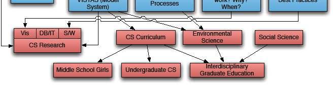
7 VISTAS Research Goals Computer Science R&D Env.Science Research Social Science Inquiry Judith Cushing, Evergreen Michael Bailey, OSU Barbara Bond, HJA Bob McKane, EPA Marc Stieglitz, Ga. Tech Denise Lach, OSU Christophe Thomas, OSU Ed Rastetter, Woods Hole. Co-develop Visualizations and Software Outreach to Practitioners Study Co-development & Ask: Which Visualizations Work? With whom? Why? Northwest Computer Science Consortium to Enhance the Study of Climate Change Burnett, Delcambre, Maier, Orr, Shapiro, Suciu Susan Stafford, U. Minn
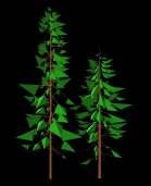
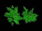
8 VISTAS Current Status / Visualizations forest stand catchment basin
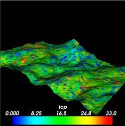
9 VISTAS Current Status / Visualizations Soil moisture March 2, 1994 March 10, 1994 High values are blue, low values, red. soil moisture & dissolved inorganic nitrogen side-by-side.

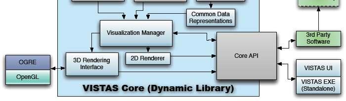
10 VISTAS Current Status / Architecture
11 Ancillary Activities & Broader Impacts. Survey Visual Analytics at LTER Sites Integrate use of LTER Ecology Data into Teaching QM Use visualizations for science outreach? Deliver interdisciplinary CS/Ecology Undergrad Curriculum Interest Middle School Girls by Ecology Visualization Work with Native Americans and Science Stories Raise CS Awareness of Interesting Ecology Problems Bring recent CS research to bear on this problem Describe dynamics of scientific software development.
12 Prior work (inspiring &) leading to award CanopyDB, CanopyView Grasslands Data Integration, EEON Nalini Nadkarni, Lee Zeman, Nik Molnar, Anne McIntosh, Dylan Fischer, Carri Leroy And, Evergreen Interdisciplinary Prob lem Oriented Curricular Approach 12
 Data")

13 Data Collection Ecology Data Management (traditionally) Data Archiving Long Term Data for Climate Change Research & Mitigation, & Resource Management 13


14 ECOLOGICAL DATA MANAGEMENT alternatively ARCHIVE Data Metadata Data Collection/Generation Stockpile 14
15 Information Entropy over Time Time of publication Information usefulness at 10 years, 20 years, 30 years Information Con ntent Accident Specific details General details Retirement or career change Death Time after Michener et al., 1997 From knb.ecoinformatics.or
16 Information Entropy over Time Time of publication Information usefulness at 10 years, 20 years, 30 years Information Con ntent Accident Specific details General details Retirement or career change Death Time after Michener et al., 1997 From knb.ecoinformatics.or
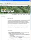
17 Canopy Database Project Vision Database technology can ease your data management, data entry, validation, archiving, metadata provision, and data mining for synthesis BUT Researchers aren t programmers, so The tools must be easy to use & research productivity. Access is pretty easy.. 17


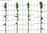
18 A Relational Database Example Each place has one or more stems (1..m relationship) Each stem has one or more branches. How do you know which place a particular stem is associated with?

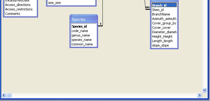
19 Our Database 19


20 An Even More Complex Example! (real world dataset)
21 Canopy DataBank: From Database Technology aimed at archiving Study Design Field Work Data Entry & Verification Data Analysis Data Sharing (w/in Group) Journal Publication Data Archive Data Mining Metadata Generation Archive in Lab(common types) Data Visualization Statistical analysis Data validation (against metadata) Data and metadata capture Database and Protocol Design Research Reference Tools Information Synthesis 21
22 to CanopyView: Data Visualization & Analysis: Data Analytics Study Design Field Work Data Entry & Verification Data Analysis Data Sharing (w/in Group) Journal Publication Data Archive Data Mining Metadata Generation Archive in Lab(common types) Visual analytics Data validation (against metadata) Data and metadata capture Database and Protocol Design Research Reference Tools Visual analytics Information Synthesis 22
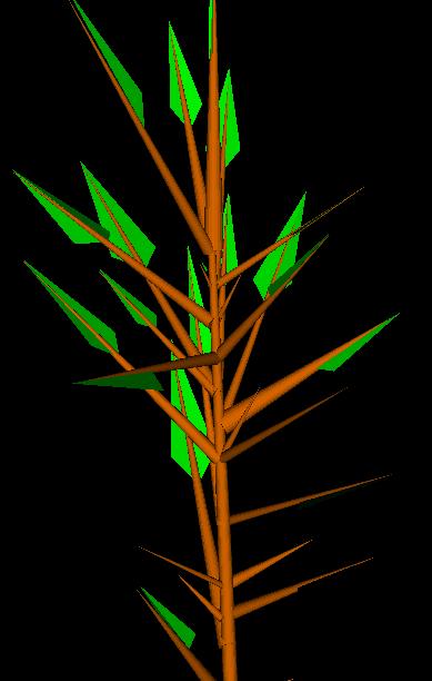
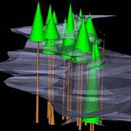
23 CanopyView Canopy View 23


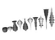
24 CanopyView sometimes 2D is better... Canopy View 24
25 Yosemite Animations. What s different? Modeled Data, and LOTS of it Field Data over time Complex Topography (DEMs) Visualizing Processes. 25
NSF:ABI-BIO , S&CC-IIS-CISE
 VISTAS Visualization of Terrestrial & Aquatic Systems Exploring data on topographically complex landscapes http://blogs.evergreen.edu/vistas An Interdisciplinary Team of Computer Scientists, Social Scientists
VISTAS Visualization of Terrestrial & Aquatic Systems Exploring data on topographically complex landscapes
 VISTAS Visualization of Terrestrial & Aquatic Systems Exploring data on topographically complex landscapes http://blogs.evergreen.edu/vistas An Interdisciplinary Team of Computer Scientists, Social Scientists
Which Visualizations Work, for What Purpose, for Whom? Evaluating Visualizations of Terrestrial and Aquatic Systems
 Which Visualizations Work, for What Purpose, for Whom? Evaluating Visualizations of Terrestrial and Aquatic Systems Judith Bayard Cushing, Evan Hayduk, Jerilyn Walley The Evergreen State College Olympia
Superimposing Spatial Enrichments in Traditional Information
 Superimposing Spatial Enrichments in Traditional Information 1 Lois Delcambre, 1 David Maier, 1 Mathew Weaver, 2 Leonard Shapiro, 3 Judith Bayard Cushing 1 Computer Science Dept. OGI School of Science
Education Toolkits for the 21 rst Century Ecological Research
 Education Toolkits for the 21 rst Century Ecological Research NEON s University Education / Outreach Program Leah A. Wasser, Sr. Science Educator, Remote Sensing Ecologist Wendy Gram, Liz Goehring National
Overview. Project Background Project Approach: Content and Application Development Application Demonstration Future Developments
 Overview Project Background Project Approach: Content and Application Development Application Demonstration Future Developments Southeast Pressures: Continued Population Growth Transportation Corridors
Remote Sensing for Ecosystems
 MODULE GUIDE MSc ENR Remote Sensing for Ecosystems Semester 01 Modul coordinator Lecturers Michael Döring Pascal Ochsner, Diego Tonolla, Diane Whited, Michael Döring Martin Geilhausen Latest update August
Application of GIS Technology in Watershed-based Management and Decision Making
 Application of GIS Technology in Watershed-based Management and Decision Making U. Sunday Tim Iowa State University Department of Agricultural and Biosystems Engineering 100 Davidson Hall Email:
DataONE: Enabling Data-Intensive Biological and Environmental Research through Cyberinfrastructure
 DataONE: Enabling Data-Intensive Biological and Environmental Research through Cyberinfrastructure Presented by John W. Cobb, Ph.D. Computer Science and Mathematics Office of Cyberinfrastructure National
3/29/11. Why bother with tools? Incorporating Decision Support Tools into Climate Adaptation Planning. A Simplified Planning Process
 Incorporating Decision Support Tools into Climate Adaptation Planning Why bother with tools? Tools don t eliminate complexity but they can help deal with it" Tools can:"! Help incorporate science into
Biodiversity Blueprint Overview
 Biodiversity Blueprint Overview Climate Variability Climate projections for the Glenelg Hopkins Regions suggest that the weather will be hotter and drier in the coming years which will impact on land use,
Alaska ACE Education Programs
 Alaska ACE Education Programs Elena Bautista Sparrow, Tania Clucas, Holly McQueen, Sarai, Timothy, Chip McMuellen, Gary Kofinas, Sanjay Pyare, Andy Kliskey, Tom Moran, Alan Boraas, John Monahan, Denise
Ministry of Health and Long-Term Care Geographic Information System (GIS) Strategy An Overview of the Strategy Implementation Plan November 2009
 Strategy An Overview of the Strategy Implementation Plan November 2009") Ministry of Health and Long-Term Care Geographic Information System (GIS) Strategy An Overview of the Strategy Implementation Plan November 2009 John Hill, Health Analytics Branch Health System Information
Ministry of Health and Long-Term Care Geographic Information System (GIS) Strategy An Overview of the Strategy Implementation Plan November 2009 John Hill, Health Analytics Branch Health System Information
Using Big Interagency Databases to Identify Climate Refugia for Idaho s Species of Concern
 Using Big Interagency Databases to Identify Climate Refugia for Idaho s Species of Concern What is a Climate Refugia? habitat that supports a locally reproducing population [or key life history stage]
Manual of Digital Earth
 V8.0 March 27, 2018 International Society for Digital Earth Manual of Digital Earth (Tentative Title) OUTLINE Foreword Chapter 1 Understanding Digital Earth 1.1 Origins and Precursors of Digital Earth
An Integrated Habitat Classification and Map of the Lake Erie Basin: Final Report
 An Integrated Habitat Classification and Map of the Lake Erie Basin: Final Report Dr. Lucinda Johnson Natural Resources Research Institute University of Minnesota 5013 Miller Trunk Highway, Duluth, MN
Inquiry in the Garden - Stage 2 Alternate Field Investigation
 Saguaro Cactus Activity Overview In this investigation, students venture outside for a teacher led, plant discovery walk in their own schoolyard. This activity is offered as an alternative field investigation
Techniques for Science Teachers: Using GIS in Science Classrooms.
 Techniques for Science Teachers: Using GIS in Science Classrooms. After ESRI, 2008 GIS A Geographic Information System A collection of computer hardware, software, and geographic data used together for
GIS and Coastal Nutrients Luke Cole
 GIS and Coastal Nutrients Luke Cole Human population density has been widely utilized as a valid predictor of terrestrial nitrogen loads into marine systems. As 50% of the world s population lives within
A GIS helps you answer questions and solve problems by looking at your data in a way that is quickly understood and easily shared.
 WHAT IS GIS? A geographic information system (GIS) integrates hardware, software, and data for capturing, managing, analyzing, and displaying all forms of geographically referenced information. GIS allows
OCEANOGRAPHIC DATA MANAGEMENT
 OCEANOGRAPHIC DATA MANAGEMENT Presented to: Environmental Disaster Data Management Meeting Russ Beard Director, National Coastal Data Development Center Interim Science Coordinator, Gulf Restoration Council
GIS in Weather and Society
 GIS in Weather and Society Olga Wilhelmi Institute for the Study of Society and Environment National Center for Atmospheric Research WAS*IS November 8, 2005 Boulder, Colorado Presentation Outline GIS basic
Effects of input DEM data spatial resolution on Upstream Flood modeling result A case study in Willamette river downtown Portland
 Effects of input DEM data spatial resolution on Upstream Flood modeling result A case study in Willamette river downtown Portland By Hue Duong GEOG 593 Fall 2015 Digital Terrain Analysis Photo: Anh Duc
ZFL, Center of Remote Sensing of Land Surfaces, University of Bonn, Germany. Geographical Institute, University of Bonn, Germany
 Communication of Research Results The IMPETUS Atlas H.-P. Thamm 1, M. Judex 1, O.Schultz 2, S.Krüger 1 & M. Christoph 3 1 ZFL, Center of Remote Sensing of Land Surfaces, University of Bonn, Germany 2 Geographical
The Invasion of False Brome in Western Oregon
 The Invasion of False Brome in Western Oregon GIS II Presentation Winter 2006 Will Fellers Kurt Hellerman Kathy Strope Statia Cupit False Brome (Brachypodium sylvaticum) Perennial bunchgrass native to
ENVS S102 Earth and Environment (Cross-listed as GEOG 102) ENVS S110 Introduction to ArcGIS (Cross-listed as GEOG 110)
 ENVS S110 Introduction to ArcGIS (Cross-listed as GEOG 110)") ENVS S102 Earth and Environment (Cross-listed as GEOG 102) 1. Describe the fundamental workings of the atmospheric, hydrospheric, lithospheric, and oceanic systems of Earth 2. Explain the interactions
ENVS S102 Earth and Environment (Cross-listed as GEOG 102) 1. Describe the fundamental workings of the atmospheric, hydrospheric, lithospheric, and oceanic systems of Earth 2. Explain the interactions
Archaeology & Digital Humanities
 WAYNE STATE UNIVERSITY Archaeology & Digital Humanities The D.I.R.T. on Big Data STRENGTHENING THE BIG DATA & ANALYTICS ECOSYSTEM WAYNE STATE UNIVERSITY Krysta Ryzewski Associate Professor of Anthropology
MesoWest Accessing, Storing, and Delivering Environmental Observations
 MesoWest Accessing, Storing, and Delivering Environmental Observations John Horel, University of Utah John.horel@utah.edu http://mesowest.utah.edu Goal: promote and support access, storage, and use of
B.Tech (Electronics & Computer Engineering)
") School Of Electronics (SENSE) B.Tech (Electronics & Computer ) CURRICULUM [Curriculum for Applied Learning (CAL3.1)] Sl. No Category Total number of Credits 1 University Core (UC) 70 2 University Elective(UE)
School Of Electronics (SENSE) B.Tech (Electronics & Computer ) CURRICULUM [Curriculum for Applied Learning (CAL3.1)] Sl. No Category Total number of Credits 1 University Core (UC) 70 2 University Elective(UE)
United States Department of the Interior NATIONAL PARK SERVICE Northeast Region
 United States Department of the Interior NATIONAL PARK SERVICE Northeast Region June 17, 2017 REQUEST FOR STATEMENTS OF INTEREST and QUALIFICATIONS Project Title: ASSESSMENT OF NATURAL RESOURCE CONDITION
The CUAHSI Hydrologic Information System
 The CUAHSI Hydrologic Information System Presented by Dr. Tim Whiteaker The University of Texas at Austin 18 November, 2010 Session T1B About the Speaker PhD 2004 Research Associate What You Will Learn
Millennium Ecosystem Assessment
 Millennium Ecosystem Assessment Global Data Challenges from an MA perspective Global Spatial Data and Information User Workshop 21-23 September 2004! What is the MA?! How and what kinds of data does it
Introduction. Ecology is the scientific study of the interactions between organisms and their environment.
 Introduction Ecology is the scientific study of the interactions between organisms and their environment. 1. The interactions between organisms and their environments determine the distribution and abundance
Observatories in the context of the Digital Continent: CZO s and HIS
 Observatories in the context of the Digital Continent: CZO s and HIS Dr. Richard P. Hooper, President, Consortium of Universities for the Advancement of Hydrologic Science, Inc. Why Observatories? From
INTEGRATING GEOSPATIAL PERSPECTIVES IN THE ANTHROPOLOGY CURRICULUM AT THE UNIVERSITY OF NEW MEXICO (UNM)
") INTEGRATING GEOSPATIAL PERSPECTIVES IN THE ANTHROPOLOGY CURRICULUM AT THE UNIVERSITY OF NEW MEXICO (UNM) VERONICA ARIAS HEATHER RICHARDS JUDITH VAN DER ELST DEPARTMENT OF ANTHROPOLOGY MARCH 2005 INTEGRATING
INTEGRATING GEOSPATIAL PERSPECTIVES IN THE ANTHROPOLOGY CURRICULUM AT THE UNIVERSITY OF NEW MEXICO (UNM) VERONICA ARIAS HEATHER RICHARDS JUDITH VAN DER ELST DEPARTMENT OF ANTHROPOLOGY MARCH 2005 INTEGRATING
Lesson Plan 3 Land Cover Changes Over Time. An Introduction to Land Cover Changes over Time
 An Introduction to Land Cover Changes over Time This lesson plan builds on the lesson plan on Understanding Land Use and Land Cover Using Google Earth. Please refer to it in terms of definitions on land
Environmental Science Institute The University of Texas - Austin
 Environmental Science Institute The University of Texas - Austin Geologic Wonders of Central Texas Dr. Leon Long This file contains suggestions for how to incorporate the material from this CDROM into
GIS Data, Technology, and Models. to Integrate Information and Improve Transportation Decision-Making. within the Eco-Logical* Framework for Oregon
 GIS Data, Technology, and Models to Integrate Information and Improve Transportation Decision-Making within the Eco-Logical* Framework for Oregon GIS-T 2009, Oklahoma City, OK April 8, 2009, Session 5..2.2
Faculty Environmental Sciences» Department Geosciences» Chair for Geoinformationsystems Developing Scientific GDI DGEO Workshop
 Faculty Environmental Sciences» Department Geosciences» Chair for Geoinformationsystems Developing Scientific GDI DGEO Workshop Lars Bernard, Stephan Mäs February 2013 TU Dresden GIS Team Chair Geoinformationsystems
Impact of DEM Resolution on Topographic Indices and Hydrological Modelling Results
 Impact of DEM Resolution on Topographic Indices and Hydrological Modelling Results J. Vaze 1, 2 and J. Teng 1, 2 1 Department of Water and Energy, NSW, Australia 2 ewater Cooperative Research Centre, Australia
environment Biotic Abiotic
 1 Ecology is the study of the living world and the interactions among organisms and where they live; it is the study of interactions between living (animals, plants) and nonliving (earth, air, sun water)
Digital Wetlands. Bringing the Field into the Office Through GIS
 Digital Wetlands Bringing the Field into the Office Through GIS Maryland Department of the Environment Wetlands and Waterways Program MDE's Wetlands and Waterways Program seeks to conserve valuable aquatic
GIS at UCAR. The evolution of NCAR s GIS Initiative. Olga Wilhelmi ESIG-NCAR Unidata Workshop 24 June, 2003
 GIS at UCAR The evolution of NCAR s GIS Initiative Olga Wilhelmi ESIG-NCAR Unidata Workshop 24 June, 2003 Why GIS? z z z z More questions about various climatological, meteorological, hydrological and
SAON. Finnish Perspectives
 SAON Finnish Perspectives Challenges and opportunities Kari Laine THULE institute University of Oulu Finnish Perspectives: Challenges and opportunities Northern Long-Term Socio-Ecological Research Platform
Interdisciplinary Teaching in and beyond Geoscience: Thinking outside the Box
 Interdisciplinary Teaching in and beyond Geoscience: Thinking outside the Box Rosemary Capo, University of Pittsburgh Kyle Fredrick, California University of PA Interdisciplinary Teaching Introductory
Teaching GIS Technology at UW-Superior. Volume 9, Number 8: May 23, 2003
 Teaching GIS Technology at UW-Superior Volume 9, Number 8: May 23, 2003 William Bajjali University of Wisconsin, department of Biology and Earth Science, Superior, WI 54880 Abstract As educators, it is
Spatial Data Availability Energizes Florida s Citizens
 NASCIO 2016 Recognition Awards Nomination Spatial Data Availability Energizes Florida s Citizens State of Florida Agency for State Technology & Department of Environmental Protection Category: ICT Innovations
RHOAPS. Real-time Hydrology Ocean Atmosphere Prediction System. Pronunciation: Ropes Motto: More than just THREDDS
 RHOAPS Real-time Hydrology Ocean Atmosphere Prediction System Pronunciation: Ropes Motto: More than just THREDDS Key Aspects Integrated real-time data systems Atmospheric Hydrologic Coastal oceans Societal
GIS Applications on Environmental Education in Taiwan
 GIS Applications on Environmental Education in Taiwan Track: Education Authors: Yu-Chen Lai, Mei-Ling Yeh, Tien-Yin Chou Abstract GIS is a perfect vehicle to deliver environmental knowledge and spatial
Chisoni Mumba. Presentation made at the Zambia Science Conference 2017-Reseachers Symposium, th November 2017, AVANI, Livingstone, Zambia
 Application of system dynamics and participatory spatial group model building in animal health: A case study of East Coast Fever interventions in Lundazi and Monze districts of Zambia Chisoni Mumba Presentation
Ecosystem Indicators. Age Poom. Environmental Management Master Course CAU Ecology Centre SS 2006
 Ecosystem Indicators Age Poom Environmental Management Master Course CAU Ecology Centre SS 2006 Indicator definitions Purpose of development and use of indicators Characteristics and requirements of indicators
Case Study. Lesson 3. NOS 8 Scientific Explanations
 Lesson 3 Case Study Skim Lesson 3 in your book. Read the headings and look at the photos and illustrations. Identify three things you want to learn more about as you read the lesson. Record your ideas
Development of the Hydrologic Model
 Kick-off meeting on enhancing hydrological data management and exchange procedures Water and Climate Adaptation Plan (WATCAP) for Sava River Basin Development of the Hydrologic Model David Heywood Team
ENV208/ENV508 Applied GIS. Week 1: What is GIS?
 ENV208/ENV508 Applied GIS Week 1: What is GIS? 1 WHAT IS GIS? A GIS integrates hardware, software, and data for capturing, managing, analyzing, and displaying all forms of geographically referenced information.
STAGE 2 GEOGRAPHY: Natural environments
 STAGE 2 GEOGRAPHY: Natural environments Focus area: The Earth s environment Different environments Significance of environments Key inquiry questions How does the environment support the lives of people
SPECCHIO for Australia: taking spectroscopy data from the sensor to discovery for the Australian remote sensing community
 University of Wollongong Research Online Faculty of Science, Medicine and Health - Papers Faculty of Science, Medicine and Health 2013 SPECCHIO for Australia: taking spectroscopy data from the sensor to
Lesson Plan 3 Google Earth Tutorial on Land Use for Middle and High School
 An Introduction to Land Use and Land Cover This lesson plan builds on the lesson plan on Understanding Land Use and Land Cover Using Google Earth. Please refer to it in terms of definitions on land use
Existing NWS Flash Flood Guidance
 Introduction The Flash Flood Potential Index (FFPI) incorporates physiographic characteristics of an individual drainage basin to determine its hydrologic response. In flash flood situations, the hydrologic
Model Implementation Details for the Final Project in EEOS 465/
 Model Implementation Details for the Final Project in EEOS 465/627 2009 Last week, we introduced a conceptual model of estimating DOC loadings from landscape to coastal waters as a model template for the
Geography for the 2020 Round of Census
 Boundaries Key Census Data EA Id Population Male Female EA Id Area EA Id Num HH Avg HH size Geography for the 2020 Round of Census Linda Peters, Esri lpeters@esri.com Integration of Statistical and Geospatial
Arctic ecosystem services: TEEB Arctic Scoping study. Alexander Shestakov WWF Global Arctic Programme 3 December Arctic Biodiversity Congress
 Arctic ecosystem services: TEEB Arctic Scoping study Alexander Shestakov WWF Global Arctic Programme 3 December 20143 Arctic Biodiversity Congress Content 1. Project design 2. Approach 3. Challenges and
DEM-based Ecological Rainfall-Runoff Modelling in. Mountainous Area of Hong Kong
 DEM-based Ecological Rainfall-Runoff Modelling in Mountainous Area of Hong Kong Qiming Zhou 1,2, Junyi Huang 1* 1 Department of Geography and Centre for Geo-computation Studies, Hong Kong Baptist University,
Mapping for a Changing California
 Mapping for a Changing California Spatial Data Science: - the 21 st century mapping toolkit - case studies in remote sensing and participatory informatics -where to get more information Maggi Kelly, University
USGS National Geospatial Program Understanding User Needs. Dick Vraga National Map Liaison for Federal Agencies July 2015
 + USGS National Geospatial Program Understanding User Needs Dick Vraga National Map Liaison for Federal Agencies July 2015 + Topics 2 Background Communities of Use User Surveys National Map Liaisons Partnerships
The Current Status of EarthCube with an EarthScope Perspective. Tim Ahern IRIS Director of Data Services
 The Current Status of EarthCube with an EarthScope Perspective Tim Ahern IRIS Director of Data Services Key Aspects of EarthCube EarthCube Empowers cross-domain data discovery, interoperability, Current
Native species (Forbes and Graminoids) Less than 5% woody plant species. Inclusions of vernal pools. High plant diversity
 Less than 5% woody plant species. Inclusions of vernal pools. High plant diversity") WILLAMETTE VALLEY WET-PRAIRIE RESTORATION MODEL WHAT IS A WILLAMETTE VALLEY WET-PRAIRIE Hot Spot s Native species (Forbes and Graminoids) Rare plant species Less than 5% woody plant species Often dominated
WILLAMETTE VALLEY WET-PRAIRIE RESTORATION MODEL WHAT IS A WILLAMETTE VALLEY WET-PRAIRIE Hot Spot s Native species (Forbes and Graminoids) Rare plant species Less than 5% woody plant species Often dominated
George Host and Tom Hollenhorst Natural Resources Research Institute University of Minnesota Duluth
 George Host and Tom Hollenhorst Natural Resources Research Institute University of Minnesota Duluth Marc Hershfield Minnesota Pollution Control Agency Duluth, MN St. Louis River watershed Duluth-Superior
Interdisciplinary research for carbon cycling in a forest ecosystem and scaling to a mountainous landscape in Takayama,, central Japan.
 Asia-Pacific Workshop on Carbon Cycle Observations (March 17 19, 2008) Interdisciplinary research for carbon cycling in a forest ecosystem and scaling to a mountainous landscape in Takayama,, central Japan.
GIS Visualization: A Library s Pursuit Towards Creative and Innovative Research
 GIS Visualization: A Library s Pursuit Towards Creative and Innovative Research Justin B. Sorensen J. Willard Marriott Library University of Utah justin.sorensen@utah.edu Abstract As emerging technologies
General Education Foundations F1 - Composition & Rhetoric 3-6 ENGL 101 & ENGL 102
 Chemistry 1 Chemistry Degree Awarded Bachelor of Science Nature of Program Chemistry is the study of the composition, structure and properties of matter. Chemists work in the growing fields of biotechnology,
Conservation and Transportation Colorado Pilot Workshop Tools and Approaches with CDOT Environmental Geodatabase and Data Initiative
 Conservation and Transportation Colorado Pilot Workshop 2006 Tools and Approaches with CDOT Environmental Geodatabase and Data Initiative Who and What: Intro Concepts: Kimberly Majerus, FHWA-Resource Center
Overview of the current status of application of GIS and RS in soil and water management in Republic of Macedonia
 Overview of the current status of application of GIS and RS in soil and water management in Republic of Macedonia Dr. Dusko Mukaetov Institute of Agriculture Blvd. Aleksandar Makedonski b.b., 1000 Skopje,
An Alternate Career Choice for the Geography Major: Map, GIS, or Geographic Information Librarianship
 An Alternate Career Choice for the Geography Major: Map, GIS, or Geographic Information Librarianship Katherine H. Weimer Texas A&M University Libraries SWAAG 2007 - Bryan, Texas Overview of today s talk
USING HYPERSPECTRAL IMAGERY
 USING HYPERSPECTRAL IMAGERY AND LIDAR DATA TO DETECT PLANT INVASIONS 2016 ESRI CANADA SCHOLARSHIP APPLICATION CURTIS CHANCE M.SC. CANDIDATE FACULTY OF FORESTRY UNIVERSITY OF BRITISH COLUMBIA CURTIS.CHANCE@ALUMNI.UBC.CA
Computer Science and Logic A Match Made in Heaven
 A Match Made in Heaven Luca Aceto Reykjavik University Reykjavik, 3 April 2009 Thanks to Moshe Vardi from whom I have drawn inspiration (read stolen ideas ) for this presentation. Why This Talk Today?
Living in a Watershed
 Living in a Watershed Department of Ecosystem Science and Ma... http://ecosystems.psu.edu/youth/sftrc/lesson-plans/water/k-5/watershed Department of Ecosystem Science and Management Youth Living in a Watershed
Development of Univ. of San Agustin Geographic Information System (USAGIS)
") , pp.170-176 http://dx.doi.org/10.14257/astl.2014.48.27 Development of Univ. of San Agustin Geographic Information System (USAGIS) Rosslin John H. Robles Chair, Computer Science Department, University
, pp.170-176 http://dx.doi.org/10.14257/astl.2014.48.27 Development of Univ. of San Agustin Geographic Information System (USAGIS) Rosslin John H. Robles Chair, Computer Science Department, University
Mapping and Modeling for Regional Planning
 Mapping and Modeling for Regional Planning Carol W. Witham Sacramento Valley Chapter California Native Plant Society contributors: David Ackerly John Dittes Julie Evens Josephine Guardino Robert F. Holland
Land Administration and Cadastre
 Geomatics play a major role in hydropower, land and water resources and other infrastructure projects. Lahmeyer International s (LI) worldwide projects require a wide range of approaches to the integration
SWAMP GIS: A spatial decision support system for predicting and treating stormwater runoff. Michael G. Wing 1 * and Derek Godwin
 Journal of Spatial Hydrology Vol. 11, No. 2 Fall 2011 SWAMP GIS: A spatial decision support system for predicting and treating stormwater runoff Michael G. Wing 1 * and Derek Godwin Abstract SWAMP GIS
Sneak Preview of the Saskatchewan Soil Information System (SKSIS)
") Sneak Preview of the Saskatchewan Soil Information System (SKSIS) Angela Bedard-Haughn 1, Ken Van Rees 1, Murray Bentham 1, Paul Krug 1 Kent Walters 1,3, Brandon Heung 2, Tom Jamsrandorj 3 Ralph Deters
Sneak Preview of the Saskatchewan Soil Information System (SKSIS) Angela Bedard-Haughn 1, Ken Van Rees 1, Murray Bentham 1, Paul Krug 1 Kent Walters 1,3, Brandon Heung 2, Tom Jamsrandorj 3 Ralph Deters
U.S. Continental Scientific Drilling and Coring Science Plan Paleorecords community - Highlights
 U.S. Continental Scientific Drilling and Coring Science Plan 2018-2028 Paleorecords community - Highlights Earth systems across time Sediment records in mud and rock on the Earth s continents offer an
CPSC 695. Future of GIS. Marina L. Gavrilova
 CPSC 695 Future of GIS Marina L. Gavrilova The future of GIS Overview What is GIS now How GIS was viewed before Current trends and developments Future directions of research What is GIS? Internet's definition
Transactions on Information and Communications Technologies vol 18, 1998 WIT Press, ISSN
 STREAM, spatial tools for river basins, environment and analysis of management options Menno Schepel Resource Analysis, Zuiderstraat 110, 2611 SJDelft, the Netherlands; e-mail: menno.schepel@resource.nl
Harrison 1. Identifying Wetlands by GIS Software Submitted July 30, ,470 words By Catherine Harrison University of Virginia
 Harrison 1 Identifying Wetlands by GIS Software Submitted July 30, 2015 4,470 words By Catherine Harrison University of Virginia cch2fy@virginia.edu Harrison 2 ABSTRACT The Virginia Department of Transportation
Branches of Science. How many branches of science do you know Copyright 2010 Ryan P. Murphy
 Branches of Science How many branches of science do you know. - - - - - - - - Types of scientists Biology The study of life. Geology The study of Earth. Chemistry The study of Matter. Physics The study
econtentplus GS Soil
 econtentplus GS Soil General aims Assessment and strategic development of INSPIRE compliant Geodata-Services for European Soil Data BPN on basis of the EU 2007/2/EC (INSPIRE) Directive for Annex III theme
The Earth's Environment - A Marshy Mystery Stage 2 Geography
 The Earth's Environment - A Marshy Mystery Stage 2 Geography Summary This unit is written for Stage 2 "The Earth's Environment". It is a Geographical Inquiry, enabling students to work through the 3 stages
Earth Science through Food, Games, and Art: Library Programming Ideas for Tweens and Teens
 Earth Science through Food, Games, and Art: Library Programming Ideas for Tweens and Teens HANDS-ON SCIENCE ACTIVITIES Presenters: Eve Halligan, Keliann LaConte, and Stephanie Shipp Technical Support:
Hudson River Estuary Climate Change Lesson Project. Grades 5-8 Teacher s Packet. Lesson 3. Climate Change in My City
 Grades 5-8 Teacher s Packet Lesson 3 Climate Change in My City Teacher s Packet 2 Climate Change in My City NYS Intermediate Level Science Standard 1: Analysis, Inquiry and Design/Scientific Inquiry S1.3
Updating of the Finnish Drainage Basin System and Register Case VALUE
 Updating of the Finnish Drainage Basin System and Register Case VALUE Juha Oksanen 1, Matti Joukola 2, Riitta Teiniranta 2, Jaakko Suikkanen 2, Tapani Sarjakoski 1 1 Department of Geoinformatics and Cartography,
The Architecture of the Georgia Basin Digital Library: Using geoscientific knowledge in sustainable development
 GEOLOGIJA 46/2, 343 348, Ljubljana 2003 The Architecture of the Georgia Basin Digital Library: Using geoscientific knowledge in sustainable development B. BRODARIC 1, M. JOURNEAY 2, S. TALWAR 2,3, R. HARRAP
Earth Lab Post-Doctoral Research and Teaching Scholars at the University of Colorado-Boulder
 Earth Lab Post-Doctoral Research and Teaching Scholars at the University of Colorado-Boulder The Earth Lab initiative, part of the University of Colorado Boulder s Grand Challenge: Our Space, Our Future,
CHAPTER 52: Ecology. Name: Question Set Define each of the following terms: a. ecology. b. biotic. c. abiotic. d. population. e.
 CHAPTER 52: Ecology 1. Define each of the following terms: a. ecology b. biotic c. abiotic d. population e. community f. ecosystem g. biosphere 2. What is dispersal? 3. What are the important factors that
The Added Value of Geospatial Data in a Statistical Office. Pedro Diaz Munoz Director Sectoral and Regional Statistics EUROSTAT European Commission
 The Added Value of Geospatial Data in a Statistical Office Pedro Diaz Munoz Director Sectoral and Regional Statistics EUROSTAT European Commission Why integrate Responsibility of all the information we
Quail Habitat Assessment
 Quail Habitat Assessment A struggle for survival at the Pea Ridge National Military Park Created by Michael Moser, Environmental Special Problem, Kurtis Cecil, Instructor Special thanks to: Professor Lowrey,
Realizing benefits of Spatial Data Infrastructure A user s perspective from Environment Agency - Abu Dhabi
 Realizing benefits of Spatial Data Infrastructure A user s perspective from Environment Agency - Abu Dhabi Anil Kumar Director, Environment Information Management 26 April 2012 Geospatial World Forum,
Geo-spatial Analysis for Prediction of River Floods
 Geo-spatial Analysis for Prediction of River Floods Abstract. Due to the serious climate change, severe weather conditions constantly change the environment s phenomena. Floods turned out to be one of
Prentice Hall Science Explorer - Georgia Earth Science 2009
 Prentice Hall 2009 Grade 6 C O R R E L A T E D T O Georgia Performance s for Science Grade 6 FORMAT FOR CORRELATION TO THE GEORGIA PERFORMANCE STANDARDS Subject Area: Science State-Funded Course: Science/Grade
Existing GIS Resources on the Indus Basin
 Existing GIS Resources on the Indus Basin Workshop on Spatial Information Analysis for the Sustainable Management of the Indus Basin in Pakistan May 26-27, 2003 Elements of Existing GIS Resources Data