PC-IDEA Final Report of Activities
|
|
|
- Deborah Christiana Lawrence
- 5 years ago
- Views:
Transcription


1 PC-IDEA Final Report of Activities Luiz Paulo Souto Fortes President of PC-IDEA 10 th United Nations Regional Cartographic Conference for the Americas August 2013, New York, United States
 To maximize the economic, social and environmental benefits derived from the use of Geospatial Information Accomplished through knowledge and exchange of")
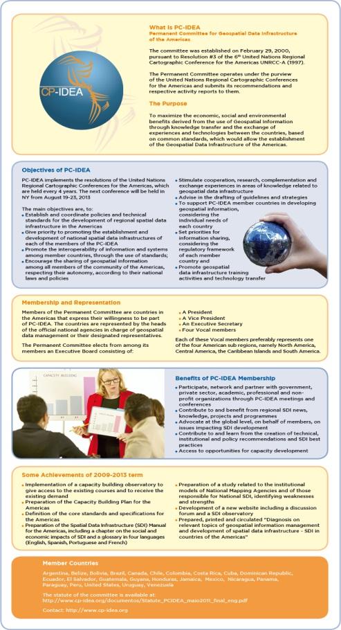
2 Permanent Committee for Geospatial Data Infrastructure of the Americas (PC IDEA) Established on February 29, 2000, based on the Resolution #3 of the 6 th United Nations Regional Cartographic Conference for the Americas UNRCC-A (1997) To maximize the economic, social and environmental benefits derived from the use of Geospatial Information Accomplished through knowledge and exchange of experiences and technologies between countries, based on common standards which would allow the establishment of the Geospatial Data Infrastructure of the Americas It implements the regional mechanism associated to the United Nations Global Geospatial Information Management (UN-GGIM) initiative

3 PC IDEA Objectives Establish and coordinate policies and technical standards for the development of geospatial data infrastructure for the Americas Promote the establishment and development of NSDI in each PC IDEA member country Promote the interoperability of information and systems among member countries, through the use of standards Encourage the sharing of geospatial information among all member countries in the Americas, while respecting their autonomy and their national laws and policies Stimulate cooperation, research, complementation and sharing of experience in areas of knowledge related to geospatial data Advise in the drafting of guidelines and strategies to support PC IDEA member countries in developing geospatial information, considering the individual needs of each country Set priorities for information sharing, considering the regulatory framework of each member country Promote SDI training activities and technology transfer
4 Member Countries Argentina Belize Bolivia Brazil Canada Chile Colombia Costa Rica Dominican Cuba Ecuador El Salvador Republic Guatemala Guyana Honduras Jamaica Mexico Nicaragua Panama Paraguay Peru United States Uruguay Venezuela
5 Distribution of countries by region Region Number of Countries Number of PC-IDEA Member Countries North America Central America South America The Caribbean % Source: ECLAC


6
7 President Luiz Paulo Souto Fortes (Brazil) Vice President Executive Secretary Valéria Araújo (Brazil) North America Vocal Member Ivan DeLoatch (USA) Central America Vocal Member Edwin Guillermo Santos Mansilla (Guatemala) Caribbean Vocal Member South America Vocal Member Matias Fortuño (Chile)
8 Vice President Mr. Mario Reyes INEGI / Mexico Mr. Cristian Aqueveque SNIT /Chile Mr. Esteban Tohá SNIT /Chile Now: Vacant Central America Vocal Changes in the Executive Board Caribbean s Vocal Mr. Eloy Luis Alum Ortiz (Crnl) ONHG / Cuba Mr. Cándido Regalado (Crnl) ONHG / Cuba Now: Vacant Mr. Ronald Estuardo Arango Ordoñez IGN / Guatemala Mr. Oscar Leonel Figueroa Cabrera IGN / Guatemala Mr Edwin Guillermo Santos Mansilla IGN / Guatemala South America Vocal Mr. Cristian Aqueveque SNIT /Chile Mr. Esteban Tohá SNIT /Chile Mr. Matías Soto Fortuño SNIT /Chile

 Principal")


9 PC IDEA Members, Collaborators and UN Staff People involved ( ) Principal and Substitute Members: 66 WG on Planning: 27 WG on Standards and Tech. Specifications: 16 UN Staff: 6 TOTAL: 115

10 New Statute The document was approved in May 2010, as follows: 17 votes in favor and 1 abstention (6 countries did not submit their votes). Spanish and English idea.org/documentos/estatuto_cpidea_maio2011_final_esp.pdf idea.org/documentos/statute_pcidea_maio2011_final_eng.pdf
 Institutional strengthening, education and training b) Technical standards and specifications c) Best practices and")

11 Resolutions of 9 th UNRCC A (implemented by PC IDEA in ) 1. Establishment of PC-IDEA Working Groups on: a) Institutional strengthening, education and training b) Technical standards and specifications c) Best practices and applications d) Innovations for national mapping agency business models 2. Establishment of mechanisms for the construction of SDI in the region 3. Survey on the state of mapping by countries 4. Creation of a forum to exchange and share SDI best practices 5. Organization of an event to discuss disaster and risk management and SDI 6. Funding issues 7. Support of the construction of SDI in developing countries, especially in the Caribbean region

 in May 2010")


12 Working Groups Working Group on Planning (GTplan) in May 2010 (Chile and Canada) Working Group on Standards and Technical Specifications (GTnet) in Dec 2012 (Mexico)

13 PC IDEA Working Group on Planning (GTplan) A questionnaire with 76 questions was designed by GTplan and applied to PC-IDEA member countries in 2011 In 2013, a subset of the 2011 questionnaire was applied to PC-IDEA member countries to assess the advances during these 2 years The results of both questionnaires fed the subsequent activities towards establishing and implementing PC- IDEA work plan
14 Working Group on Standards and Technical Specifications (GTnet) Coordination: Mexico Bolivia, Brazil, Canada, Colombia, Honduras Collaboration of the Open Geospatial Consortium (OGC) GOAL To establish a set of standards and technical specifications that apply to the region within a common scenario, considering and respecting the specificities of each country. ACTIVITIES Developing a vision for the integration of geospatial information in the region, through the use of standards Establishing the state of the art in the development and use of standards, as well as multinational profiles in the region Preparing proposals of core standards for the region Coordinating the participation in regional organizations and normalization initiatives Developing manuals related to use of the standards for the daily management of information


15 Seminar Spatial Data Infrastructures SDI as a Natural Disaster Risk Management Service August 17, 2012, during the Second Latin America Geospatial Forum LAGF 2012, in Rio de Janeiro, Brazil PC IDEA in partnership with Geospatial Media and Communications To promote the exchange of experiences and concepts in the design, development and advancements of the components of an SDI in natural disaster risks management, emphasizing the use of geospatial information Attendance: professionals and experts from public, private, academic and non governmental organizations from the region, involved in issues related to SDI and the management of disaster risks


16 Seminar Spatial Data Infrastructures SDI as a Natural Disaster Risk Management Service Themes 1.SDI for risk management of natural disasters 2.Geographic information for the awareness of the risk 3.SDI in defining processes and protocols for the management of natural disaster risks 4.Information technologies for the management of risks: earth observation technologies 5.Geographic Information Systems Participating Institutions UFRJ Brazil PC IDEA INPE Brasil / International Charter GeoConnections Canada SNIT Chile CENAD / Defesa Civil Nacional Brazil DigitalGlobe, Brazil Instituto Geografico Nacional do Panama Tommy Guardia Panama

17 Seminar Spatial Data Infrastructures SDI as a Natural Disaster Risk Management Service Recommendations 1. Countries make data, metadata and information aimed at emergency prevention and response available 2. UN, supported by regional bodies, such as PC IDEA, PCGIAP, CODIST etc. encourage governments in their various instances to create and maintain their respective national SDI 3. The creation of a working group, under CP IDEA, aiming at studying the specific use of SDI for managing risks of natural disasters in the Americas 4. The participation of the countries of the Caribbean region in PC IDEA be encouraged 5. The creation of mechanisms that consider the possibility of assessment and, when appropriate, the incorporation of geospatial information obtained through voluntary contributions 6. All levels of government involved in the control and monitoring of these phenomena assess the possibility of becoming potential sources of funding for predisaster phases, i.e., that these instances are able to fund and support SDI 7. That a second edition of the event, preferably within one year, be carried
18 Financial Resources CYTED Convocation "Ibero American Network to improve and enhance the use of spatial data infrastructures (SDI) in territorial planning" Objective: stimulate the creation of a scientific and technological research network associated to PC IDEA Brazil, Chile, Colombia, Cuba, Guatemala and Portugal 33,000 per year for a four year project. The proposal was presented in April 2010 World Bank "Strengthening of Spatial Data Infrastructures (SDI) of the Americas" World Bank (Brazil) in 2010 Objective: maximize the economic, social and environmental benefits of the use of geospatial information, seeking to promote the SDI construction in countries that have not started this process, as well as strengthening the implementation and sustainability of existing SDI in the countries of the Americas US$ 672,645 for three years

 has already started to be discussed between the involved entities to support the release of these")
19 Financial Resources Pan American Institute of Geography and History (PAIGH) Submitted in May 2012 to cover PC IDEA Working Groups activities taking into account their alignment to the PAIGH Pan American Agenda which seeks to support national initiatives based on international standards and concepts of spatial data infrastructure USD 8,000 in 2013 Approved at the 44th Meeting of the PAIGH Steering Council, held in Buenos Aires, Argentina, in November 2012 A cooperation mechanism with PC IDEA through the United Nations (UNSD) has already started to be discussed between the involved entities to support the release of these resources
20 Final Products Theme Product Type Capacity Building Standards and Technical Specifications Best Practice Innovations Capacity Building Observatory User Manual Capacity Building Observatory Implementation Strategy of Capacity Building Plan 2013 Plan of Courses Implementation Overview of the Standards Framework of the Americas Proposal of CORE Standards of the Americas Geospatial Data Model of the Americas Standards Database Spatial Data Infrastructure (SDI) Manual for the Americas Best Practice List Diagnosis about Innovation in National Mapping Agencies in countries of the Americas Website Document Document Document Document Document Document Website Document Website Document Tecnology General Website User Manual Website PC IDEA Final Report of Activities Diagnosis on relevant topics of geospatial information management and development of Spatial Data Infrastructures (SDI) in countries of the America 2011 Diagnosis on relevant topics of geospatial information management and development of Spatial Data Infrastructures (SDI) in countries of the Americas 2013 Website Document Document Document Document


21 SDI Manual Diagnosis about Innovations on NMO
22 Diagnosis about Innovation on National Mapping Agencies in countries of the Americas Aspects of NMA surveyed Institution name and mission Type of institution (18 civil and 6 military) Sectorial partnerships Production scope Products types Legal establishment (Canada: the oldest 1842) Address (virtual and physical) Innovations Relationship with NSDI


23 Diagnoses on relevant topics of geospatial information management and development of SDI in countries of the Americas 2011 and 2013


24 Publications/Database on Standards and Technical Specifications


25 Plan of Courses User Manual (Capacity Building Observatory) Capacity Building Observatory Implementation Strategy of Capacity Building Plan

26 User Manual New Website idea.org/
27


28 Other activities of the Committee Website management Mexico to Brazil Brazil to Chile Meetings and participation in events: 26 Presentations: 60 Texts for news and interviews in magazines and journals Dissemination of the work and activities of the Committee through specific marketing material and e mail Dissemination of news and events of interest to the mailing list of members and contributors Preparation of various reports to the Committee and other bodies Preparation of the marketing material (folders, banners, front pages, publications, )


29 Marketing material, templates and new logo Banners Flyers Templates New logo
30 Publications, books, magazines and interviews


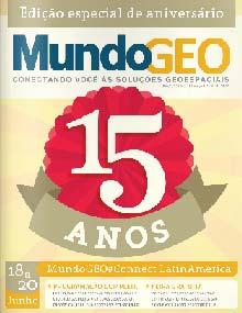
31 MundoGEO Latin America 2013 Special Award For the activities carried out during the past four years towards the development of Spatial Data Infrastructures in the Americas


32 Cooperation and Partnerships 1. PAIGH SIRGAS PC IDEA GeoSUR Joint Action Plan This policy document aims to fostering the development of SDI of the Americas, harmonizing efforts and work plans, and avoiding duplication Available in Spanish, English and Portuguese 44th PAIGH Steering Council Meeting Buenos Aires, November

 and the United States")

33 Cooperation and Partnerships 2. Cooperation proposal between the Panamerican Institute of Geography and History (PAIGH) and the United States Statistics Division (UNSD) regarding PC IDEA activities. This proposal is under discussion between the involved entities.


34 Final Comments All goals established by the 9th UNRCC A have been achieved, in addition to many products/activities that have been generated/carried out during this term. The work plan has been implemented in such a way that the next Executive Board may promote its continuity, in case this is envisaged. Numerous working meetings have been held during this term: 4 plenary meetings 1 Executive Board meeting 7 GTplan meetings Besides, a large number of virtual meetings have also been held. All these activities have certainly contributed to the achievement of all goals for this period


35 Final Comments PC IDEA recognizes the importance of the UN GGIM initiative, which aims to set a high level forum, coordinated by the member countries, for global geospatial information management. PC IDEA was glad with the opportunity of actively contributing to the process of building this initiative and its corresponding UN Committee of Experts.

36 Acknowledgements Many thanks to all colleagues and institutions for supporting PC-IDEA activities during the term, specially to: PC-IDEA Executive Board WG coordinators and members PC-IDEA members UNSD Luiz Paulo Souto Fortes President of PC-IDEA Instituto Brasileiro de Geografia e Estatística IBGE luiz.fortes@ibge.gov.br
Policies towards SDI development and implementation in the Americas
 Policies towards SDI development and implementation in the Americas Valéria Oliveira Henrique de Araújo Executive Secretary of CP-IDEA Brazilian Institute of Geography and Statistics - IBGE Geospatial
PAN AMERICAN INSTITUTE OF GEOGRAPHY AND HISTORY Specialized Organization of the OAS
 PAN AMERICAN INSTITUTE OF GEOGRAPHY AND HISTORY Specialized Organization of the OAS 10 th UNRCC Americas United Nations, New York, 20 August 2013 PAIGH, SIRGAS, PC-IDEA and GeoSUR 2013-2015 Joint Action
UN-GGIM:Americas Regional Report
 UN-GGIM:Americas Regional Report 2016-2017 Seventh Session of UN-GGIM 2-4 August 2017, United Nations Headquarters, New York. Rolando Ocampo President of UN-GGIM: Americas Content Activities, Areas of
2018/1 The integration of statistical and geospatial information. The Regional Committee of UN-GGIM: Americas:
 The following are the conclusions and recommendations of the Regional Committee of the United Nations on Global Geospatial Information Management for the Americas, during its Fifth Session, Thursday 8
The Pan American Institute of Geography and History (PAIGH) North America National Mapping Meeting May 10, 2018
 North America National Mapping Meeting May 10, 2018") The Pan American Institute of Geography and History (PAIGH) North America National Mapping Meeting May 10, 2018 Pan American Institute of Geography and History (PAIGH) PAIGH was founded in 1928 and their
The Pan American Institute of Geography and History (PAIGH) North America National Mapping Meeting May 10, 2018 Pan American Institute of Geography and History (PAIGH) PAIGH was founded in 1928 and their
Economic and Social Council 19 June 2013
 ADVANCE UNEDITED VERSION UNITED NATIONS E/C.20/2013/16/Add.1 Economic and Social Council 19 June 2013 Committee of Experts on Global Geospatial Information Management Third session Cambridge, United Kingdom
A Glimpse at Geodetic Activities in Latin America
 UNIVERSIDADE DO ESTADO DO RIO DE JANEIRO CENTRO DE TECNOLOGIA E CIÊNCIAS FACULDADE DE ENGENHARIA DEPARTAMENTO DE ENGENHARIA CARTOGRÁFICA A Glimpse at Geodetic Activities in Latin America Prof. Luiz Paulo
Regional Report UN-GGIM:Americas
 Regional Report UN-GGIM:Americas 2014-2015 June 26, 2015 1 1. Summary The Initiative of the United Nations Global Geospatial Information Management for the Americas (UN-GGIM: Americas) was created in August
Inventory of United Nations Resolutions on Cartography Coordination, Geographic Information and SDI 1
 Inventory of United Nations Resolutions on Cartography Coordination, Geographic Information and SDI I. Resolutions on Cartography Coordination and Establishment of United Nations Regional Cartographic
Development Of Common Frameworks And Methodologies *
 HIGH LEVEL FORUM ON GLOBAL GEOSPATIAL MANAGEMENT INFORMATION WORKING PAPER No. 9 First Forum Seoul, Republic of Korea, 24-26 October 2011 Development Of Common Frameworks And Methodologies * * Submitted
Background Document: Report of the Regional Committee of United Nations Global Geospatial Information Management for Asia and the Pacific
 Background Document: Report of the Regional Committee of United Nations Global Geospatial Information Management for Asia and the Pacific 1. Summary 1. This report highlights the activities carried out
Tenth United Nations Regional Cartographic Conference for the Americas New York, August Proposed Organization of Work
 Tenth United Nations Regional Cartographic Conference for the Americas New York, 19-23 August 2013 Proposed Organization of Work UN-GGIM and the Americas, addressing global challenges through geospatial
Report of Uruguay The National Spatial Data Infrastructure
 Report of Uruguay The National Spatial Data Infrastructure Prepared for High-Level Forum on Global Geospatial Information Management (GGIM) and Inaugural Session of the UN Committee of Experts on GGIM
Report of the Regional Committee of UN-GGIM for Asia and the Pacific (UN-GGIM-AP)
") Report of the Regional Committee of UN-GGIM for Asia and the Pacific (UN-GGIM-AP) At the Eighth Session of UN-GGIM UN Headquarters, New York, 1 3 August 2018 About UN-GGIM-AP One of the five regional committees
Report of the Regional Committee of UN-GGIM for Asia and the Pacific (UN-GGIM-AP) At the Eighth Session of UN-GGIM UN Headquarters, New York, 1 3 August 2018 About UN-GGIM-AP One of the five regional committees
Economic and Social Council
 United Nation E/C.20/2012/4/Add.1 Economic and Social Council Distr.: General 2 July 2012 Original: English Committee of Experts on Global Geospatial Information Management Second session New York, 13-15
Geocentric Reference System for the Americas 4th Session UN-GGIM Americas April 2017, Santiago, Chile
 Geocentric Reference System for the Americas 4th Session UN-GGIM Americas April 2017, Santiago, Chile María Virginia Mackern Vicepresidente SIRGAS Consejo Nacional de Investigaciones Científicas y Técnicas,
EuroGeoSurveys & ASGMI The Geological Surveys of Europe and IberoAmerica
 EuroGeoSurveys & ASGMI The Geological Surveys of Europe and IberoAmerica Geological Surveys, what role? Legal mandate for data & information: Research Collection Management Interpretation/transformation
gabga Regional Report UN-GGIM: Americas
 gabga Regional Report UN-GGIM: Americas 2017-2018 June, 2018 CONTENT 1. Background 2. Objective 3. Activities Work Areas 3.1. Working Groups 3.1.1. Working Group on Integration of Statistical and Geospatial
ECONOMIC AND SOCIAL COUNCIL
 UNITED NATIONS E/CONF.102/3 ECONOMIC AND SOCIAL COUNCIL Nineteenth United Nations Regional Cartographic Conference for Asia and the Pacific Bangkok, 29 October 1 November 2012 Item 4 of the provisional
Incorporation of the Caribbean to the Geocentric Reference System for the Americas SIRGAS
 Incorporation of the Caribbean to the Geocentric Reference System for the Americas SIRGAS W. Martínez M. V. Mackern V. Cioce R. Rodino S.R. De Freitas UN-GGIM: Americas Third Session, October 5 2016, Mexico
8 th Arctic Regional Hydrographic Commission Meeting September 2018, Longyearbyen, Svalbard Norway
 8 th Arctic Regional Hydrographic Commission Meeting 11-13 September 2018, Longyearbyen, Svalbard Norway Status Report of the Arctic Regional Marine Spatial Data Infrastructures Working Group (ARMSDIWG)
Funding models for institutional arrangements in the context of a national SDI: the case of Chile
 Funding models for institutional arrangements in the context of a national SDI: the case of Chile Alvaro Monett Hernández Executive Secretary SNIT Chile Vice-President UN-GGIM Américas Fifth Meeting of
UN-GGIM: Strengthening Geospatial Capability
 Fifth Plenary Meeting of UN-GGIM: Europe Brussels, 6-7 June 2018 UN-GGIM: Strengthening Geospatial Capability Walking the talk to leave no one behind Greg Scott, UN-GGIM Secretariat Environmental Statistics
From PCGIAP to UN GGIM AP: A Regional Perspective on GGIM
 Regional Committee of United Nations Global Geospatial Information Management for Asia and the Pacific (UN-GGIM-AP) Established by a United Nations Resolution From PCGIAP to UN GGIM AP: A Regional Perspective
Geospatial Information Management in the Americas: Lessons for the Post-2015 development agenda
 Geospatial Information Management in the Americas: Lessons for the Post-2015 development agenda Rolando Ocampo President, UN-GGIM: Americas October 2014 The integration of statistical and geographical
Arctic Spatial Data Infrastructure Enabling Access to Arctic Location-Based Information
 Arctic Spatial Data Infrastructure Enabling Access to Arctic Location-Based Information Arctic SDI Side Event Co-Chairs: Arvo Kokkonen Arctic SDI Board Chair & Director General, National Land Survey of
Proposal of CORE Standards of the Americas 2O13
 Proposal of CORE Standards of the Americas 2O13 PERMANENT COMMITTEE FOR GEOSPATIAL DATA INFRASTRUCTURE OF THE AMERICAS (PC-IDEA) 2009 2013 President Luiz Paulo Souto Fortes Executive Secretary Valéria
UN-GGIM: An Overview Stefan Schweinfest, Director (UNSD) Bangkok, 27 March 2015
 Bangkok, 27 March 2015") UN-GGIM: An Overview Stefan Schweinfest, Director (UNSD) Bangkok, 27 March 2015 ggim.un.org UN-GGIM: A global initiative Formal inter-governmental UN Committee of Experts to: Discuss, enhance and coordinate
UN-GGIM: An Overview Stefan Schweinfest, Director (UNSD) Bangkok, 27 March 2015 ggim.un.org UN-GGIM: A global initiative Formal inter-governmental UN Committee of Experts to: Discuss, enhance and coordinate
XXII GENERAL ASSEMBLY OF MINISTERS AND MAXIMUM AUTHORITIES OF HOUSING AND URBANISM OF LATIN AMERICA AND THE CARIBBEAN
 XXII GENERAL ASSEMBLY OF MINISTERS AND MAXIMUM AUTHORITIES OF HOUSING AND URBANISM OF LATIN AMERICA AND THE CARIBBEAN Taking into account: Santiago, Chile 1 and 2 October 2013 DECLARATION OF SANTIAGO 1.
Implementing the Sustainable Development Goals: The Role of Geospatial Technology and Innovation
 Fifth High Level Forum on UN Global Geospatial Information Management Implementing the Sustainable Development Goals: The Role of Geospatial Technology and Innovation 28-30 November 2017 Sheraton Maria
GeoSUR Award Sixth Competition (2017)
") GeoSUR Award Sixth Competition (2017) GeoSUR was created in 2007 with the financial backing of the CAF and in joint coordination with the Pan American Institute of Geography and History (PAIGH). The fundamental
GeoSUR Award Sixth Competition (2017) GeoSUR was created in 2007 with the financial backing of the CAF and in joint coordination with the Pan American Institute of Geography and History (PAIGH). The fundamental
Pan American Institute of Geography and History. 12th MACHC 5-9 December 2011
 Pan American Institute of Geography and History 12th MACHC 5-9 December 2011 1 PAIGH Mission and Objectives To encourage, coordinate, and publicize cartographical, geographical, geophysical and historical
NSDI Implementation. Milo Robinson FGDC. U. S. Policy OMB Circular A-16 From Global GSDI To Local Canadian/ U.S. Projects
 NSDI Implementation Milo Robinson FGDC U. S. Policy OMB Circular A-16 From Global GSDI To Local Canadian/ U.S. Projects Federal Geographic Data Committee (FGDC) A US Federal Interagency committee responsible
Organization of American States PAN AMERICAN INSTITUTE OF GEOGRAPHY AND HISTORY
 Organization of American States PAN AMERICAN INSTITUTE OF GEOGRAPHY AND HISTORY REPORT ON ACTIVITIES March 2016 February 2017 http://www.ipgh.org 2 Contents Basic Information Pan American Institute for
ACTION PLAN FOR WORLD HERITAGE IN LATIN AMERICA AND THE CARIBBEAN ( )
") Annex ACTION PLAN FOR WORLD HERITAGE IN LATIN AMERICA AND THE CARIBBEAN (2014-2024) The current Regional Action Plan for Latin America and the Caribbean for 2014-2024 has been elaborated by the State Parties
Annex ACTION PLAN FOR WORLD HERITAGE IN LATIN AMERICA AND THE CARIBBEAN (2014-2024) The current Regional Action Plan for Latin America and the Caribbean for 2014-2024 has been elaborated by the State Parties
UN GGIM and National SDI Strategy
 MSDI Open Forum on 26 th January 2016 Contributing to the successful delivery of MSDI UN GGIM and National SDI Strategy Hiroshi Murakami Deputy Administrator Geospatial Information Authority of Japan Geospatial
Spatially Enabled Society
 International Seminar on Land Administration Trends and Issues in Asia and the Pacific Region Spatially Enabled Society Abbas Rajabifard Vice Chair PCGIAP-WG3 Vice-President (President Elect), GSDI Association
INTERNATIONAL HYDROGRAPHIC ORGANIZATION MESO AMERICAN & CARIBBEAN SEA HYDROGRAPHIC COMMISSION
 INTERNATIONAL HYDROGRAPHIC ORGANIZATION MESO AMERICAN & CARIBBEAN SEA HYDROGRAPHIC COMMISSION CAPACITY BUILDING PLAN Programme document for the period 2010-2012 1. INTRODUCTION 1.1. Rationale It is estimated
The UN discusses Global Geospatial Information Management
 The UN discusses Global Geospatial Information Management Just like statistics, every country must have authoritative, trusted, maintained, definitive mapping data Professor Paul Cheung, Director, United
Economic and Social Council
 United Nations Economic and Social Council Distr.: General 18 July 2016 Original: English Committee of Experts on Global Geospatial Information Management Sixth session New York, 3-5 August 2016 Item 2
Introduction to time-use surveys
 Regional seminar on time-use surveys Introduction to time-use surveys Kingstown, Saint Vincent and the Grenadines 10-11 December 2014 Iliana Vaca Lucía Scuro Division of Gender Affairs WHAT IS TIME? Measured
Economic and Social Council
 United Nations Economic and Social Council Distr.: General 2 July 2012 E/C.20/2012/10/Add.1 Original: English Committee of Experts on Global Geospatial Information Management Second session New York, 13-15
Geographical Names Activities in Africa The Gaborone Action Plan
 United Nations Group of Experts on Geographical Names Geographical Names Activities in Africa The Gaborone Action Plan 6 th Meeting of the Committee of Director -Generals of National Statistics Offices
Brazil Paper for the. Second Preparatory Meeting of the Proposed United Nations Committee of Experts on Global Geographic Information Management
 Brazil Paper for the Second Preparatory Meeting of the Proposed United Nations Committee of Experts on Global Geographic Information Management on Data Integration Introduction The quick development of
KUNMING FORUM ON UNITED NATIONS GLOBAL GEOSPATIAL INFORMATION MANAGEMENT CITIES OF THE FUTURE: SMART, RESILIENT
 KUNMING FORUM ON UNITED NATIONS GLOBAL GEOSPATIAL INFORMATION MANAGEMENT CITIES OF THE FUTURE: SMART, RESILIENT and SUSTAINABLE Yunnan Zhenzhuang Guest House, Kunming, China 10 12 May 2017 BACKGROUND CONCEPT
Status of interoperability issues in the Chilean SDI. Álvaro Monett Pablo Morales Executive Secretariat NSDI-Chile
 Status of interoperability issues in the Chilean SDI Álvaro Monett Pablo Morales Executive Secretariat NSDI-Chile Outline Background - Chilean SDI working areas Background Interoperability, standards and
AMERICAS GLOBAL MAP PROPOSED TECHNICAL PLAN
 AMERICAS GLOBAL MAP PROPOSED TECHNICAL PLAN A Way to Pan-American Integration PATROCINADO POR : Pan-American Institute for Geography and History - PAIGH International Steering Committee for Global Mapping
The Third UN-GGIM-AP Plenary Meeting. ICA Report as Liaison Organization of UN-GGIM-AP. Bali Indonesia 10 November 2014
 The Third UN-GGIM-AP Plenary Meeting ICA Report as Liaison Organization of UN-GGIM-AP Bali Indonesia 10 November 2014 Sukendra Martha Vice President International Cartographic Association (ICA) Outline
Brazilian National Spatial Data Infrastructure (INDE): Applicability for Large Scale Data
: Applicability for Large Scale Data") Brazilian National Spatial Data Infrastructure (INDE): Applicability for Large Scale Data Andrea Lopes Iescheck*, Marco Aurélio Dorneles** * Federal University of Rio Grande do Sul UFRGS, Institute of
Brazilian National Spatial Data Infrastructure (INDE): Applicability for Large Scale Data Andrea Lopes Iescheck*, Marco Aurélio Dorneles** * Federal University of Rio Grande do Sul UFRGS, Institute of
Cooperation is the key, FIG can facilitate
 Cooperation is the key, FIG can facilitate Mikael Lilje Vice President 2017-2020 Head, Geodetic infrastructure, Swedish mapping, cadastral and land registration authority Presented at the GIS/RS Conference
Survey of the Development of National Spatial Data Infrastructures in Latin America and the Caribbean
 Copyright 2002 by the authors. Published here under license by International Center for Tropical Agriculture (CIAT) and Instituto Geografico Agustin Codazzi (IGAC). Survey of the Development of National
Permanent Committee on Spatial Data Infrastructure for the Americas PC IDEA
 Permanent Committee on Spatial Data Infrastructure for the Americas PC IDEA A Status Report presented at the 7 th Meeting of the Permanent Committee on GIS Infrastructure for Asia and the Pacific PCGIAP
SIRGAS: Basis for Geosciences, Geodata, and Navigation in Latin America
 SIRGAS: Basis for Geosciences, Geodata, and Navigation in Latin America Claudio Brunini President of SIRGAS Universidad Nacional de La Plata, Argentina María Virginia Mackern President of SIRGAS/WG-I:
NCAVES - Global initiative and national pilots
 NCAVES - Global initiative and national pilots Kavita Sharma UN Environment Pretoria, March 2018 Outline 1. Global initiative > Introduction > Objectives and deliverables >Activities in 2017 and 2018 2.
Geographical Names: Relevance and place within the UN-GGIM framework
 Geographical Names: Relevance and place within the UN-GGIM framework Greg Scott Inter-Regional Advisor Global Geospatial Information Management United Nations Statistics Division UN-GGIM: A global initiative
WGCapD Support to AmeriGEOSS Week Disaster Training Report
 WGCapD Support to AmeriGEOSS Week Disaster Training Report 1 6-9 June 2016 CEOS WGCapD Support to AmeriGEOSS Week Disaster training DRAFT REPORT Hosted by: The government's Institute of Hydrology, Meteorology,
Methodology used in preparing the estimates and projections of the urban and rural population and the economically active population
 CEPAL América Latina y el Caribe. Observatorio demográfico Nº 2 Población económicamente activa Methodology used in preparing the estimates and projections of the urban and rural population and the economically
Bengt Kjellson Chair of the Executive Committee UN-GGIM: Europe. 2 nd Joint UN-GGIM: Europe ESS Meeting 11 th March 2016, Luxembourg
 Bengt Kjellson Chair of the Executive Committee UN-GGIM: Europe 2 nd Joint UN-GGIM: Europe ESS Meeting 11 th March 2016, Luxembourg A global geospatial mandate At its 47th plenary in July 2011, ECOSOC,
GEOSUR PROGRAM. Geospatial Information for the South American Integration
 GEOSUR PROGRAM Geospatial Information for the South American Integration Eric van Praag, Jesús Suniaga Andean Development Corporation (Corporación Andina de Fomento CAF, in Spanish) Information Needs of
Ministry of Health and Long-Term Care Geographic Information System (GIS) Strategy An Overview of the Strategy Implementation Plan November 2009
 Strategy An Overview of the Strategy Implementation Plan November 2009") Ministry of Health and Long-Term Care Geographic Information System (GIS) Strategy An Overview of the Strategy Implementation Plan November 2009 John Hill, Health Analytics Branch Health System Information
Ministry of Health and Long-Term Care Geographic Information System (GIS) Strategy An Overview of the Strategy Implementation Plan November 2009 John Hill, Health Analytics Branch Health System Information
Major Opportunities in Spatial Data Infrastructure Communities
 Major Opportunities in Spatial Data Infrastructure Communities Bas Kok President GSDI June 17 th 2008 FIG Working Week: Integrating Generations 14-19 June 2008 Stockholm, Sweden http://www.gsdi.org 1 GSDI
GSDI: Towards a Spatially Enabled Society
 GSDI: Towards a Spatially Enabled Society Dr. David J. Coleman, President Global Spatial Data Infrastructure Association UN Regional Cartographic Conference for the Americas, United Nations, New York,
CHAPTER 22 GEOGRAPHIC INFORMATION SYSTEMS
 CHAPTER 22 GEOGRAPHIC INFORMATION SYSTEMS PURPOSE: This chapter establishes the administration and use of to improve the quality and accessibility of Department s spatial information and support graphical
Crisis Support and Disaster Response. in Latin America and the Caribbean
 Crisis Support and Disaster Response in Latin America and the Caribbean The Pan American Agenda 2010-2020 of the Pan American Institute of Geography and History (PAIGH), and the resulting 2010 Implementation
Global Mapping: A Tool for Disaster Mitigation
 Global Mapping: A Tool for Disaster Mitigation D. R. Fraser Taylor Chair, International Steering Committee for Global Mapping (ISCGM) fraser_taylor@carleton.ca www. United Nations Regional Cartographic
What is the PCGIAP? Overview on PCGIAP Activities and the Asia/Pacific Region. Membership. Background. Aims. Asia-Pacific SDI
 3rd FIG Regional Conference for Asia and the Pacific Jakarta, Indonesia, 3-7th October 2004 Overview on PCGIAP Activities and the Asia/Pacific Region What is the PCGIAP? Haji Matusin Matasan Surveyor General,
GROUP ON INTEGRATION OF STATISTICAL AND GEOSPATIAL INFORMATION GT-IIEG
 UN-GGIM: Americas WORKING GROUP ON INTEGRATION OF STATISTICAL AND GEOSPATIAL INFORMATION GT-IIEG Bogotá, Colombia August, 2018 www.dane.gov.co Working group GT-IIEG Objective: To raise awareness and promote
FIG Asia Pacific Capacity Development Network
 FIG Asia Pacific Capacity Development Network Report to the 41th General Assembly FIG Congress 2018, Istanbul - Turkey Rob Sarib Chair FIG Asia Pacific Capacity Development Network (AP CDN) Story of the
Space-based technology and applications and space science for humanitarian affairs, environment and security
 Space-based technology and applications and space science for humanitarian affairs, environment and security LUC ST-PIERRE United Nations Office for Outer Space Affairs United Nations Office at Vienna
UN-GGIM Quarterly. 5th High level Forum on UN-GGIM. From the Director of UNSD. Number 1, November 2017
 UN-GGIM Quarterly Number 1, November 2017 From the Director of UNSD On behalf of the UN GGIM Secretariat, I am pleased to share with you our first issue of "UN GGIM Quarterly", an electronic newsletter
Non-Governmental Organizations for Spatial Data Infrastructure. Environmental Democracy Case
 Non-Governmental Organizations for Spatial Data Infrastructure Environmental Democracy Case L.Jovičić, S.Vrečar, V.Cetl, K.Ristovski GSDI Small Grant Program Award 2011-2012 Non-Governmental Organisations
Funding systems used in Mexico to support institutional arrangements: INEGI case
 Funding systems used in Mexico to support institutional arrangements: INEGI case Sistemas de financiamiento usados en México, para soportar arreglos institucionales: Caso INEGI United Nations Committee
PAN AMERICAN INSTITUTE FOR GEOGRAPHY AND HISTORY
 Organization of American States PAN AMERICAN INSTITUTE FOR GEOGRAPHY AND HISTORY 47th MEETING OF THE DIRECTING COUNCIL REPORT OF THE GENERAL SECRETARY RODRIGO BARRIGA VARGAS November 2015 http://www.ipgh.org
Briefing. H.E. Mr. Gyan Chandra Acharya
 Briefing by H.E. Mr. Gyan Chandra Acharya Under-Secretary-General and High Representative for the Least Developed Countries, Landlocked Developing Countries and Small Island Developing States Briefing
Economic and Social Council
 United Nations E/CN.3/2019/31 Economic and Social Council Distr.: General 19 December 2018 Original: English Statistical Commission Fiftieth session 5-8 March 2019 Item 4(i) of the provisional agenda*
Challenges in Geospatial Policy Formulation and Programme Management
 Challenges in Geospatial Policy Formulation and Programme Management Luiz Paulo Souto Fortes, PhD An Exchange with the Geospatial Industry for UN-GGIM Seoul, October 23, 2011 BRAZIL Land area 8,514,876.599
20. GIS partnerships
 20. GIS partnerships Geographic Information Systems and Science SECOND EDITION Paul A. Longley, Michael F. Goodchild, David J. Maguire, David W. Rhind 2005 John Wiley and Sons, Ltd John Wiley & Sons Ltd
Report of the Working Group 2 Data Sharing and Integration for Disaster Management *
 UNITED NATIONS E/CONF.104/6 ECONOMIC AND SOCIAL COUNCIL Twentieth United Nations Regional Cartographic Conference for Asia and the Pacific Jeju, 6-9 October 2015 Item 5 of the provisional agenda Report
Economic and Social Council 2 July 2015
 ADVANCE UNEDITED VERSION UNITED NATIONS E/C.20/2015/11/Add.1 Economic and Social Council 2 July 2015 Committee of Experts on Global Geospatial Information Management Fifth session New York, 5-7 August
Summary of Global Mapping Forum 2003 in Okinawa and its Outcomes
 Summary of Global Mapping Forum 2003 in Okinawa and its Outcomes 1 Summary of Global Mapping Forum 2003 in Okinawa and its Outcomes Hidetoshi NAKAJIMA Abstract Global Mapping Forum 2003 in Okinawa was
Strategic Framework on Geospatial Information and Services for Disasters Relevance for the Americas Region
 Strategic Framework on Geospatial Information and Services for Disasters Relevance for the Americas Region Seventh Session of the Committee of Experts on UN-GGIM Side Event --- UN Headquarters, New York
E/CONF.105/158/CRP.158
 E/CONF.105/158/CRP.158 14 July 2017 Original: English Eleventh United Nations Conference on the Standardization of Geographical Names New York, 8-17 August 2017 Item 8 of the provisional agenda* Measures
COMMISSION 3 SPATIAL INFORMATION MANAGEMENT WORK PLAN
 Appendix to item 34.3 FIG Congress in Washington, 19-26 April 2002 COMMISSION 3 SPATIAL INFORMATION MANAGEMENT WORK PLAN 2002 2006 1. Title Spatial Information Management. 2. Terms of Reference - Management
US National Spatial Data Infrastructure A Spatial Framework for Governance and Policy Development to Enable a Location-Based Digital Ecosystem
 GeoPlatform Workshop 7 Dec 2016, Department of the Interior Washington, D.C. US National Spatial Infrastructure A Spatial Framework for Governance and Policy Development to Enable a Location-Based Digital
ECONOMIC AND SOCIAL COUNCIL 13 July 2007
 UNITED NATIONS E/CONF.98/CRP.34 ECONOMIC AND SOCIAL COUNCIL 13 July 2007 Ninth United Nations Conference on the Standardization of Geographical Names New York, 21-30 August 2007 Item 17(b) of the provisional
Challenges and Potentials of Place Based Information Management in Nepal"
 Nineteenth United Nations Regional Cartographic Conference for Asia and the Pacific, Bangkok, Thailand, 29 October 1 November 2012 Challenges and Potentials of Place Based Information Management in Nepal"
GSDI Global Spatial Data Infrastructure. Convergences between Geo Spatial Communities: key decision for decision making
 GSDI Global Spatial Data Infrastructure Convergences between Geo Spatial Communities: key decision for decision making April 14 th 2010 Bas Kok GSDI Past-President Director of International Affairs, Dutch
Concept Formulation of Geospatial Infrastructure. Hidenori FUJIMURA*
 Concept Formulation of Geospatial Infrastructure 1 Concept Formulation of Geospatial Infrastructure Hidenori FUJIMURA* (Published online: 28 December 2016) Abstract Technical trends in the field of surveying
Informational Graphics
 Informational Graphics Informational Graphics - (also called infographics, information design, and news graphics) Informational Graphics are visual displays that can be anything from a pleasing arrangement
United Nations Group Of Experts On Geographical Names
 Rudolph MATINDAS, Indonesia or William WATT, Australia Key words: place names, UNGEGN SUMMARY UNGEGN Discussing the strategic aims of UNGEGN and its divisional structure, future direction, and the benefits
A/AC.105/C.1/2012/CRP.10
 A/AC.105/C.1/2012/CRP.10 1 February 2012 English only Committee on the Peaceful Uses of Outer Space Scientific and Technical Subcommittee Forty-ninth session Vienna, 6-17 February 2012 Item 6 of the provisional
Global Spatial Data Infrastructure Association
 http://www.gsdi.org Global Spatial Data Infrastructure Association a global forum to support exchange of ideas and encourage joint activities at the global level Members: Think global, act local Organization:
Chris Rizos (IAG), Chair William Cartwright (ICA), immediate past Chair
, Chair William Cartwright (ICA), immediate past Chair") Chris Rizos (IAG), Chair William Cartwright (ICA), immediate past Chair Global Spatial Data Infrastructure (GSDI) Association IEEE Geoscience & Remote Sensing Society (IEEE-GRSS) International Association
Chris Rizos (IAG), Chair William Cartwright (ICA), immediate past Chair Global Spatial Data Infrastructure (GSDI) Association IEEE Geoscience & Remote Sensing Society (IEEE-GRSS) International Association
African requirements for SDI standardization Antony Cooper Operating Unit Fellow Built Environment CSIR PO Box 395, Pretoria, 0001, South Africa
 ISO/TC 211 workshop on spatial data infrastructures (SDIs) African requirements for SDI standardization Antony Cooper Operating Unit Fellow Built Environment CSIR PO Box 395, Pretoria, 0001, South Africa
The European Forum for Geospatial Statistics Benefits and challenges of INSPIRE in the field of statistics
 INSPIRE Conference 2016 Barcelona, Spain 26th 30th September 2016 The European Forum for Geospatial Statistics Benefits and challenges of INSPIRE in the field of statistics Janusz Dygaszewicz EFGS President
Report of PCGIAP to the 18 th United Nations Regional Cartographic Conference for Asia and the Pacific (UNRCC-AP) for the period
 for the period") Permanent Committee on GIS Infrastructure for Asia and the Pacific (PCGIAP) Established in 1995 by a United Nations Resolution Report of PCGIAP to the 18 th United Nations Regional Cartographic Conference
Permanent Committee on GIS Infrastructure for Asia and the Pacific (PCGIAP) Established in 1995 by a United Nations Resolution Report of PCGIAP to the 18 th United Nations Regional Cartographic Conference
Connectivity in the LAC region
 Cristián Varas, Speedchecker Ltd. Agustín Formoso, Lacnic Labs Connectivity in the LAC region A study made by LACNIC Labs and Speedchecker Ltd. Outline The challenge of measuring regions not well covered
CONFERENCE STATEMENT
 Final draft CONFERENCE STATEMENT We, the elected representatives of Canada, Denmark/Greenland, the European Parliament, Finland, Iceland, Norway, Russia, Sweden and the United States of America; In collaboration
The Role of Data & Information Infrastructures in Supporting Climate Change Adaptation in Latin America & the Caribbean
 The Role of Data & Information Infrastructures in Supporting Climate Change Adaptation in Latin America & the Caribbean Emil A. Cherrington Senior Scientist Water Center for the Humid Tropics of Latin
SDG s and the role of Earth Observation
 SDG s and the role of Earth Observation Christian Heipke IPI - Institute for Photogrammetry and GeoInformation Leibniz Universität Hannover Germany Secretary General, ISPRS 1. No Poverty 2. Zero Hunger