Climate Change Hotspots Mapping and Migration as Adaptation
|
|
|
- Hilary Ethelbert Black
- 5 years ago
- Views:
Transcription
 Population-Environment Research Network (PERN) SESYNC Boundary Spanning Workshop 12 June")
1 Climate Change Hotspots Mapping and Migration as Adaptation Alex de Sherbinin, PhD Center for International Earth Science Information Network (CIESIN) The Earth Institute at Columbia University NASA Socioeconomic Data and Applications Center (SEDAC) Population-Environment Research Network (PERN) SESYNC Boundary Spanning Workshop 12 June 2018
 SEDAC s")


2 NASA Socioeconomic Data and Applications Center (SEDAC) SEDAC s mission is to develop and operate applications that support the integration of socioeconomic and remote sensing data and to serve as an information gateway between the earth and social sciences.
3 Outline Mapping hotspots of climate change vulnerability and risk Migration as an adaptive response: results of climate-migration modeling work for the World Bank West Africa: Does the fact that migration has been a long standing adaptation strategy to climate variability mean that the region is better prepared for future climate impacts?
4 Mapping hotspots of climate change vulnerability and risk
5 SESYNC Pursuit: Meta-Analysis of Climate Change Vulnerability Mapping Studies Award Year: 2015 Principal Investigators: Alex de Sherbinin, Columbia University Brian Tomaszewski, Rochester Institute of Technology Goal: Identify the strengths and weaknesses of the various vulnerability mapping approaches and benchmark the state-of-the-art with respect to vulnerability mapping practice. See:
6 Co-Authors Alex de Sherbinin Anamaria Bukvic Guillaume Rohat Melanie Gall Brent McCusker Benjamin Preston Alex Apotsos Carolyn Fish Stefan Kienberger Park Muhonda Olga Wilhelmi Denis Macharia William Shubert Richard Sliuzas Brian Tomaszewski Sainan Zhang Affiliation CIESIN, Earth Institute, Columbia University Virginia Tech University of Geneva, and ITC, University of Twente Arizona State University West Virginia University Rand Corporation Williams College Pennsyvania State University Z_GIS, University of Salzburg West Virginia University National Center for Atmospheric Research (NCAR) Regional Centre for Mapping of Resources for Development Internews ITC, University of Twente Rochester Institute of Technology UN Population Fund (UNFPA)

7 Mapping climate vulnerability hotspots Integrates spatial variability in: Climate / biophysical changes Human / system vulnerabilities Exposure, sensitivity, and adaptive capacity are all spatially differentiated Mapping can illuminate key vulnerabilities in the coupled human-environment system and, in turn, inform where adaptation may be required. Mapping will not necessarily tell you what needs to be done or how to build resilience.

8 Mali Vulnerability Mapping: Indicators de Sherbinin et al Mali Climate Vulnerability Mapping. USAID-funded ARCC project

9 Mali Climate Vulnerability Mapping Created separate maps for: Exposure Sensitivity Adaptive Capacity Aggregated these into an overall vulnerability index Bamako de Sherbinin et al Mali Climate Vulnerability Mapping. USAID-funded ARCC project
10 Vulnerability Mapping Focus on understanding and quantifying the complex human-environment system How does the system behave in response to stressors? Ideally a vulnerability map helps to: Understand the complex drivers of vulnerability / risk Predict negative outcomes for a given stressor Predict the system s ability to recover [T]he true value of vulnerability assessment is the social learning that develops from exploring complexity viewing diverse factors that drive exposure, influence sensitivity and create barriers to adaptation which contributes to the capacity of individuals and institutions to adapt and manage risk. - Preston et al. (2009)


11

12 Climate-demography vulnerability index Red areas = high vulnerability, where current demographic growth vastly exceeds climate consistent population growth Blue areas = low vulnerability, where population growth is lower than climate consistent population growth Source: Samson, J., D. Berteaux, B.J. McGill and M.M. Humphries Geographic disparities and moral hazards in the predicted impacts of climate change on human populations. Global Ecology and Biogeography doi: /j x

13 1 3 Future Impacts: Multisectoral Hotspots of Impacts Source: Piontek F, Müller C, Pugh TAM et al (2013) Multisectoral climate impacts in a warming world. Proceedings of the National Academy of Sciences. doi: /pnas

14 Security risks associated with CC Source: Schubert, Schellnhuber, et al Climate Change as Security Risk. London: Earthscan.


15 Migration as an adaptive response: Results from the Groundswell Project Rigaud, K.K., A. de Sherbinin, B. Jones, J. Bergmann, V. Clement, K. Ober, J. Schewe, S. Adamo, B. McCusker, S. Heuser, and A. Midgley Groundswell: Preparing for Internal Climate Migration. Washington DC: World Bank.

16 At what point will rural subsistence farmers no longer be able to adapt in situ, and be forced to leave for cities and towns? Figure 2 An adaptation limit to rice cultivation leading to loss of livelihoods and security of supply. Source: Dow et al., Limits to adaptation to climate change: a risk approach. Current Opinion in Environmental Sustainability Volume 5, Issues
17 Why model CC-induced migration and population distribution? Population distributions are unlikely to evolve as they have in the past Pop projections are needed for planning purposes The humanitarian community wants projections of likely displacement for humanitarian response Receiving countries want to understand the magnitude of future flows especially of potential crisis migration Development actors are grappling with potential limits to adaptation for rural livelihoods, and how to avoid distress migration All models are wrong, but some are useful - George Box Planning is everything, the plan is nothing. - Dwight Eisenhower

18 1 8 Gravity models in spatial population research Gravity models in demography/geography are generally used to simulate aggregate human behavior or broad trends. Gravitational Potential Commonly used in models of spatial interaction, spatial allocation, migration, accessibility, and attractiveness. The gravitational pull of any location is typically measured using some local characteristic such as population, jobs, GDP, etc. As in the Newtonian laws of gravity, the attraction or interaction between places is a function of mass (population or local characteristic) and distance. Environmental characteristics can be included as push or pull factors, thus positively or negatively impacting the relative attractiveness of locations to potential migrants, and by extension, the ongoing evolution of subnational population distributions. Albany v i = Boston Hartford New York n j= 1 P D j 2 ij

 SSP-based spatial population scenarios 232 countries/territories Urban, rural, and total populations 10-year time steps, 1/8 th degree NO CLIMATE ASSUMPTIONS SSP5 Fossil Fueled Development")
19 NCAR-CIDR Spatial Population Downscaling Model Research Goal: To develop an methodology for constructing large-scale, plausible future spatial population scenarios which may be calibrated to reflect alternative regional patterns of development for use in the scenario-based assessment of global change. Characteristics Gravity-based downscaling model Captures observed geographic patterns Calibration to historic data Flexible framework Data (easy to include ancillary layers) Resolution (temporal & spatial) SSP-based spatial population scenarios 232 countries/territories Urban, rural, and total populations 10-year time steps, 1/8 th degree NO CLIMATE ASSUMPTIONS SSP5 Fossil Fueled Development Source: Jones & O Neill Spatially explicit global population scenarios consistent with the Shared Socioeconomic Pathways. Environmental Research Letters
20 2 0 Model Modifications The original model takes advantage of the observed correlation between the agglomeration effect quantified in the gravity model and urban/rural patterns of spatial population change Here we incorporate changing environmental conditions by considering sectoral impact indicators from the ISI-MIP project, specifically crop production and water availability We hypothesize that the prediction error in the original model results from missing variables, and that changes in crop production and water availability explain a portion of observed error We modified the existing NCAR-CIDR model to include local climate impacts as measured through the crop and water indicators (deviations from long term averages), as well as sealevel rise

21 2 1


22 2 2 The Inter-Sectoral Impact Model Intercomparison Project (ISI-MIP) Data

23 2 3 Model Modifications

24 2 4

25 2 5 Headline numbers Up to 140 million internal migrants by 2050 in the three regions The largest numbers are in Africa, suggesting high climate sensitivity in that region Numbers are lower for SSP2: more inclusive development, and lowest for the climatefriendly RCP2.6 scenario


26 Spatial patterns 26


27 2 7 Urbanization Urban Threshold: >=300 persons per sq. km.


28 Livelihood Systems 28

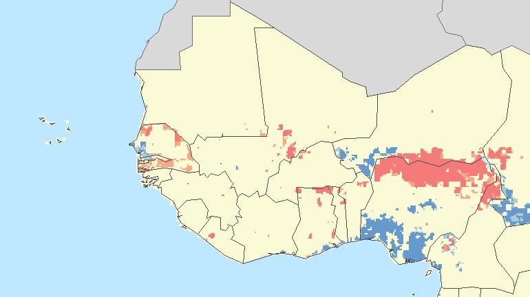
29 West Africa The canary in the cage of climate change Observed climate change hotspots, Turco et al GRL


30 Zommers et al Loss & Damage: The Role of Ecosystem Services. Nairobi: UNEP.


31 Foresight Project Net Migration Modeling Net Migration Data available at

32 Groundswell Results
33 I posed this question to the PERN* community: Is the Sahel in fact likely to be more adapted to future climate impacts than other regions of Africa because of past use of migration as an adaptive response to climate variability (especially drought)? * Population-Environment Research Network of Future Earth and the International Union for the Scientific Study of Population
34 Agreeing with: For many systems, frequent levels of stress also lead to adaptations to that stress. "in risk-prone environments where the state has little to offer, surprisingly adaptable livelihood systems can evolve. In the savannah of West Africa, for example, people have had to deal with climatic variability and environmental stresses since time immemorial, and most of the time they have done so quite successfully. Human mobility has a very central place in the adaptive strategies of farmers and pastoralists in this region. Kees van der Geest (2011), UNU-EHS I do believe these communities might be better adapted to the impacts of future CC: I have this feeling for communities of Northeastern Region of Brazil (at least, for the ones that did not migrate to other areas during drought periods). Luci Hidalgo Nunes, UNICAMP
35 Qualified Agreement with: For many systems, frequent levels of stress also lead to adaptations to that stress. Mobility is indeed inherent in the culture of most Sahelian communities and serves as important livelihood strategy. The natural environment is just one out of many reasons for mobility. My team is currently working on a systematic meta-analysis on adaptation strategies in African drylands to identify the role of migration next to many other strategies. According to our results it seems migration plays a central role in adaptation processes, but agricultural strategies are far more important. Against this background I'm a bit hesitant to reason that communities with a migration culture are better prepared for the expected cc than non-mobile societies, perhaps they are prepared just differently. Kathleen Hermans, Helmholtz Centre for Environmental Research

36 Conflicting evidence on the connection between drought / environmental factors and migration Critiquing the assumption that environmental stress is the dominating migration driver, I demonstrate the important role of individual aspirations and social processes, such as educational opportunities and the pull of urban lifestyles. Victoria van der Land (2018) Out-migration is a common practice in the two Malian villages. A season with poor rainfall is not correlated to increased levels of outmigration but may impact duration or destination. Katherine Grace et al (2018)
37 Agreeing with: The impacts of stress, however, may be more problematic when the frequency or magnitudes of stress change at rates beyond which the system can adapt and still maintain its underlying structure I find it a bit difficult to understand how it helps the communities adapt in a future context given the scale of expected changes, together with abrupt, non-linear and surprise events. Suruchi Bhadwal, TERI I spent a lot of time living and working in Niger in the late 1990s and early 2000s. I am skeptical that migration will be an effective adaptation strategy. It would have certainly been one in the past, but with the rapid population growth across the Sahel (highest in the world) and the (relatively new) insecurity that has come about in the Sahel dating back to the collapse of Libya and the rise of AQIM and Boko Haram, migration is increasingly challenging, particularly for herders such as the Fulani. Kristen Paterson, PRB
Migration Modelling using Global Population Projections
 Migration Modelling using Global Population Projections Bryan Jones CUNY Institute for Demographic Research Workshop on Data and Methods for Modelling Migration Associated with Climate Change 5 December
Examples of Vulnerability Assessment Aggregation Results from other Regions. Spatial Vulnerability Assessments
 Examples of Vulnerability Assessment Aggregation Results from other Regions Potential Vulnerability to Climate change in the European Union Kathrin Renner EURAC.Research,, Risk, Vulnerability and Climate
Overview of proposed approach to the Desktop Study to inform discussion
 LTAS Phase 2: Climate Change Implications for the Human Settlements sector in South Africa Overview of proposed approach to the Desktop Study to inform discussion Project Team Project Lead: Crispian Olver
Constructing Global-Scale Spatial Population Scenarios. Bryan Jones, CGD-IAM, NCAR Boulder, CO August 19, 2013
 Constructing Global-Scale Spatial Population Scenarios Bryan Jones, CGD-IAM, NCAR Boulder, CO August 19, 2013 NCAR Community Demographic Model (CDM) Urbanization Projection (National) Household Projection
Spatial Data Integration and Data Gaps for Climate Impacts, Vulnerability, and Adaptation
 Spatial Data Integration and Data Gaps for Climate Impacts, Vulnerability, and Adaptation Alex de Sherbinin Center for International Earth Science Information Network (CIESIN), The Earth Institute at Columbia
Environmentally-induced Population Displacements: Conclusions from PERN s Online Seminar
 Environment, Forced Migration & Social Vulnerability International Conference 9-11 October 2008 Bonn, Germany www.efmsv2008.org Environmentally-induced Population Displacements: Conclusions from PERN s
Seamless weather and climate for security planning
 Seamless weather and climate for security planning Kirsty Lewis, Principal Climate Change Consultant, Met Office Hadley Centre 28 June 2010 Global Climate Models Mitigation timescale changes could be avoided
Progress in Modeling Spatial Population Scenarios. Bryan Jones CGD-IAM, NCAR NCAR IAM Group Annual Meeting, July 19, 2012
 Progress in Modeling Spatial Population Scenarios Bryan Jones CGD-IAM, NCAR NCAR IAM Group Annual Meeting, July 19, 2012 Agenda 1. Introduction a. Importance b. Research goals 2. Methodology a. Current
PURR: POTENTIAL OF RURAL REGIONS UK ESPON WORKSHOP Newcastle 23 rd November Neil Adams
 PURR: POTENTIAL OF RURAL REGIONS UK ESPON WORKSHOP Newcastle 23 rd November 2012 Neil Adams PURR: Potential of Rural Regions Introduction Context for the project A spectrum of knowledge Rural Potentials
Applying Earth System Forecasts For Climate Change To Inform Conservation Planning Of The East African Great Lakes
 Applying Earth System Forecasts For Climate Change To Inform Conservation Planning Of The East African Great Lakes S. Asefi, D. Lawrence, P. Lawrence, A. Seimon, S. Talbot 1- University Of Virginia Department
Weather Climate Science to Service Partnership South Africa
 PROJECTS UNDERWAY Title of the Weather Climate Science to Service Partnership South Africa Together, building on an existing strong partnership, South African Weather Service and the Met Office will build
Social Science Data for High Latitudes
 LCLUC Science Team Meeting High Latitudes in the Context of the International Polar Year Social Science Data for High Latitudes 2 May 2008 Dr. Robert S. Chen Director and Senior Research Scientist, CIESIN
CIESIN Overview: Human-Environment Research and Data Mark Becker Associate Director, Geospatial Applications Division
 CIESIN Overview: Human-Environment Research and Data Mark Becker Associate Director, Geospatial Applications Division Center for International Earth Science Information Network The Earth Institute, Columbia
Assessing Social Vulnerability to Biophysical Hazards. Dr. Jasmine Waddell
 Assessing Social Vulnerability to Biophysical Hazards Dr. Jasmine Waddell About the Project Built on a need to understand: The pre-disposition of the populations in the SE to adverse impacts from disaster
Social Vulnerability Index. Susan L. Cutter Department of Geography, University of South Carolina
 Social Vulnerability Index Susan L. Cutter Department of Geography, University of South Carolina scutter@sc.edu Great Lakes and St. Lawrence Cities Initiative Webinar December 3, 2014 Vulnerability The
Urban Climate Resilience
 Urban Climate Resilience in Southeast Asia Partnership Project Introduction Planning for climate change is a daunting challenge for governments in the Mekong Region. Limited capacity at the municipal level,
Indicator: Proportion of the rural population who live within 2 km of an all-season road
 Goal: 9 Build resilient infrastructure, promote inclusive and sustainable industrialization and foster innovation Target: 9.1 Develop quality, reliable, sustainable and resilient infrastructure, including
Reducing Vulnerability to Extreme Heat: Science-Policy Interface
 Reducing Vulnerability to Extreme Heat: Science-Policy Interface Olga Wilhelmi, Mary Hayden, Jennifer Boehnert, Ursula Lauper and SIMMER research team October 23, 2013 Toronto SIMMER workshop Science-Policy
Africa RiskView MONTHLY BULLETIN JANUARY Highlights: Rainfall
 The Africa RiskView Bulletin is a monthly publication by the African Risk Capacity (ARC). ARC is a Specialised Agency of the African Union designed to improve the capacity of AU Member States to manage
UNIVERSITY OF KWAZULU-NATAL EXAMINATION: JUNE 2012 Howard College and Westville Campuses
 UNIVERSITY OF KWAZULU-NATAL EXAMINATION: JUNE 2012 Howard College and Westville Campuses SCHOOL : AGRICULTURE, EARTH AND ENVIRONMENTAL SCIENCES LEVEL : 1 MODULE : HUMAN ENVIRONMENTS CODE : GEOG 110 H1/W1
Edexcel Geography Advanced Paper 2
 Edexcel Geography Advanced Paper 2 SECTION B: SHAPING PLACES Assessment objectives AO1 Demonstrate knowledge and understanding of places, environments, concepts, processes, interactions and change, at
Together towards a Sustainable Urban Agenda
 Together towards a Sustainable Urban Agenda The City We (Youth) Want Preliminary findings from youth consultations Areas Issue Papers Policy Units 1.Social Cohesion and Equity - Livable Cities 2.Urban
Governance and Urban Nexus: Closing the gaps
 Governance and Urban Nexus: Closing the gaps Donovan Storey Chief, Sustainable Urban Development, Environment & Development Division National Dialogue on Urban Nexus in Thailand Bangkok, UNCC, 19 March
Future population exposure to US heat extremes
 Outline SUPPLEMENTARY INFORMATION DOI: 10.1038/NCLIMATE2631 Future population exposure to US heat extremes Jones, O Neill, McDaniel, McGinnis, Mearns & Tebaldi This Supplementary Information contains additional
Climate Security Vulnerability in Africa. Joshua W. Busby Assistant Professor, LBJ School of Public Affairs University of Texas - Austin
 Climate Security Vulnerability in Africa Joshua W. Busby Assistant Professor, LBJ School of Public Affairs University of Texas - Austin 1 AGENDA Brief overview of our project Discussion of our vulnerability
Interregional Cooperation in the Apennines
 INTERNATIONAL WORKSHOP THE ALPS AND THE ARDENNES: SHARING EXPERIENCES AMONG TRANSBOUNDARY MOUNTAIN AREAS Interregional Cooperation in the Apennines Massimo Sargolini, professor at the University of Camerino,
Dar es Salaam - Reality Check Workshop
 Dar es Salaam - Reality Check Workshop hosted by GIZ and Dar es Salaam City Council Introduction: Key Urban Characteristics of Dar es Salaam Challenges and Opportunities for Resilient Development in the
Personalised Learning Checklist
 Edexcel A Level Geography 1. Tectonic activity and hazards Know the major tectonic hazards Personalised Learning Checklist Explain and earthquake hazards Explain volcanic hazards Apply and know event profiles-
Declaration Population and culture
 Declaration Population and culture The ministers of the parties to the Alpine Convention regard the socio-economic and socio-cultural aspects mentioned in Article 2, Paragraph 2, Item a., as being central
ACCESSIBILITY TO SERVICES IN REGIONS AND CITIES: MEASURES AND POLICIES NOTE FOR THE WPTI WORKSHOP, 18 JUNE 2013
 ACCESSIBILITY TO SERVICES IN REGIONS AND CITIES: MEASURES AND POLICIES NOTE FOR THE WPTI WORKSHOP, 18 JUNE 2013 1. Significant differences in the access to basic and advanced services, such as transport,
16540/14 EE/cm 1 DG E 1A
 Council of the European Union Brussels, 5 December 2014 (OR. en) 16540/14 ENV 965 CULT 139 NOTE From: To: Subject: General Secretariat of the Council Delegations Charter of Rome on Natural and Cultural
Deborah Balk 1,2 Gordon McGranahan 3 Bridget Anderson 2
 Preference and Risks of Coastal Population Distribution: A systematic assessment of population and land area in urban and rural areas of coastal zones. Deborah Balk 1,2 Gordon McGranahan 3 Bridget Anderson
This table connects the content provided by Education Perfect to the NSW Syllabus.
 Education Perfect Geography provides teachers with a wide range of quality, engaging and innovative content to drive positive student learning outcomes. Designed by teachers and written by our in-house
AP Human Geography Free-response Questions
 AP Human Geography Free-response Questions 2000-2010 2000-preliminary test 1. A student concludes from maps of world languages and religions that Western Europe has greater cultural diversity than the
Climate and Health Vulnerability & Adaptation Assessment Profile Manaus - Brazil
 Climate and Health Vulnerability & Adaptation Assessment Profile Manaus - Brazil Christovam Barcellos (ICICT/Fiocruz) Diego Xavier Silva (ICICT/Fiocruz) Rita Bacuri (CPqLMD/Fiocruz) Assessment Objectives
Stability, Ability and Equity
 Stability, Ability and Equity Mobility and Protection in the Urban Context Arup Banerji Senior Director and Head of Global Practice, Social Protection and Labor The World Bank Group 1 ECONOMIC MOBILITY
What s new (or not so new) in Population and Poverty Data Initiatives
 in Population and Poverty Data Initiatives") What s new (or not so new) in Population and Poverty Data Initiatives Deborah Balk Global Spatial Data and Information User Workshop 21 September 2004 Evolution in global collection of population and poverty
What s new (or not so new) in Population and Poverty Data Initiatives Deborah Balk Global Spatial Data and Information User Workshop 21 September 2004 Evolution in global collection of population and poverty
Socioeconomic data for climate change impacts, vulnerability and adaptation assessment
 Socioeconomic data for climate change impacts, vulnerability and adaptation assessment Alex de Sherbinin Center for International Earth Science Information Network (CIESIN), The Earth Institute at Columbia
Temperature ( C) Map 1. Annual Average Temperatures Are Projected to Increase Dramatically by 2050
 Map 1. Annual Average Temperatures Are Projected to Increase Dramatically by 2050") CO UNT RY S NA P SHO T India s Hotspots The Impact of Temperature and Precipitation Changes on Living Standards Climate change is already a pressing issue for India. Temperatures have risen considerably
CO UNT RY S NA P SHO T India s Hotspots The Impact of Temperature and Precipitation Changes on Living Standards Climate change is already a pressing issue for India. Temperatures have risen considerably
Global Spatial Population Projections: What Can Be Done Now?
 Global Spatial Population Projections: What Can Be Done Now? Roosevelt House (New York, NY) September 20, 2013 Attendance Mark Montgomery (SUNY Stony Brook) Barney Cohen (UN Population Division) Corrie
Building Resilience Through Translocality
 Building Resilience Through Translocality Climate Change, Migration and Social Resilience in Rural Thailand Kayly Ober & Luise Porst Patrick Sakdapolrak, Sopon Naruchaikusol, Simon Alexander Peth, Till
Temperature ( C) Map 1. Annual Average Temperatures Are Projected to Increase Dramatically by 2050
 Map 1. Annual Average Temperatures Are Projected to Increase Dramatically by 2050") CO UNT RY S NA P SHO T Sri Lanka s Hotspots The Impact of Temperature and Precipitation Changes on Living Standards Climate change is already a pressing issue for Sri Lanka. Temperatures have risen considerably
CO UNT RY S NA P SHO T Sri Lanka s Hotspots The Impact of Temperature and Precipitation Changes on Living Standards Climate change is already a pressing issue for Sri Lanka. Temperatures have risen considerably
Disaggregation according to geographic location the need and the challenges
 International Seminar On United Nations Global Geospatial Information Management Disaggregation according to geographic location the need and the challenges 6 th 7 th November 2018 Tribe Hotel, Nairobi,
Chapter 10 Human Settlement Geography Book 1 Class 12
 CHAPTER 10 HUMAN SETTLEMENTS 1. RURAL, SUB URBAN AND URBAN SETTLEMENTS: This classification is common worldwide but the criteria differ from country to country. 5. Criteria for classification differs from
The 3V Approach. Transforming the Urban Space through Transit Oriented Development. Gerald Ollivier Transport Cluster Leader World Bank Hub Singapore
 Transforming the Urban Space through Transit Oriented Development The 3V Approach Gerald Ollivier Transport Cluster Leader World Bank Hub Singapore MDTF on Sustainable Urbanization The China-World Bank
Measuring Disaster Risk for Urban areas in Asia-Pacific
 Measuring Disaster Risk for Urban areas in Asia-Pacific Acknowledgement: Trevor Clifford, Intl Consultant 1 SDG 11 Make cities and human settlements inclusive, safe, resilient and sustainable 11.1: By
Challenges of Urbanisation & Globalisation
 Challenges of Urbanisation & Globalisation Prepared by: Khairul Hisyam Kamarudin, PhD Feb 2016 Based on original lecture note by: Wan Nurul Mardiah Wan Mohd Rani, PhD URBANIZATION What is Urbanization?
European spatial policy and regionalised approaches
 Findings of the ESPON 2006 Programme COMMIN Final Conference 26-27 April 2007 European spatial policy and regionalised approaches by Dr. Kai BöhmeB ! Territory matters Structure of presentation! Territorial
Rethinking Urbanization in the 21 st Century
 Rethinking Urbanization in the 21 st Century Karen C. Seto Professor of Geography & Urbanization Science School of Forestry & Environmental Studies Yale University SESYNC April 13, 2016 From now until
BASE FOR. New York CIES. in this paper Nations or
 UNITED NATIONS N EXPERT GROUP MEETING ON STRENGTHENING THE DEMOGRAPHIC EVIDENCE BASE FOR THE POST-2015 DEVELOPMENT AGENDA Population Division Department of Economic and Social Affairs United Nations Secretariat
The Council Study: Social assessment approach and methodology
 Preliminary draft for internal discussion The Council Study: Social assessment approach and methodology Vientiane, September 24 2015 Social /economic assessment team Basin Development Plan (BDP) Programme
Urban Spatial Scenario Design Modelling (USSDM) in Dar es Salaam: Background Information
 in Dar es Salaam: Background Information") Urban Spatial Scenario Design Modelling (USSDM) in Dar es Salaam: Background Information Modelling urban settlement dynamics in Dar es Salaam Revision: 2 (July 2013) Prepared by: Katja Buchta TUM team
Urban Spatial Scenario Design Modelling (USSDM) in Dar es Salaam: Background Information Modelling urban settlement dynamics in Dar es Salaam Revision: 2 (July 2013) Prepared by: Katja Buchta TUM team
L.A.OGALLO IGAD Climate Prediction and Applications Centre (ICPAC) Formerly known as Drought Monitoring Centre - Nairobi (DMCN)
 Formerly known as Drought Monitoring Centre - Nairobi (DMCN)") METEOROLOGICAL DROUGHT EARLY WARNING IN AFRICA L.A.OGALLO IGAD Climate Prediction and Applications Centre (ICPAC) Formerly known as Drought Monitoring Centre - Nairobi (DMCN) INTRODUCTION DROUGHT IS A
METEOROLOGICAL DROUGHT EARLY WARNING IN AFRICA L.A.OGALLO IGAD Climate Prediction and Applications Centre (ICPAC) Formerly known as Drought Monitoring Centre - Nairobi (DMCN) INTRODUCTION DROUGHT IS A
Urban Geography. Unit 7 - Settlement and Urbanization
 Urban Geography Unit 7 - Settlement and Urbanization Unit 7 is a logical extension of the population theme. In their analysis of the distribution of people on the earth s surface, students became aware
Vulnerability and Adaptation to Climate Change
 Vulnerability and Adaptation to Climate Change Prof. Dr. Christoph Görg Department of Social Sciences, University of Kasssel Head of Department Environmental Politics, UFZ Leipzig 1 Introduction: Climate
Multi-scale and multi-sensor analysis of urban cluster development and agricultural land loss in India
 Multi-scale and multi-sensor analysis of urban cluster development and agricultural land loss in India Karen C. Seto, PI, Yale Michail Fragkias, Co-I, Arizona State Annemarie Schneider, Co-I, U of Wisconsin
Leif Brottem Assistant Professor of Political Science Grinnell College Grinnell, IA
 Leif Brottem Assistant Professor of Political Science Grinnell College Grinnell, IA 50112 brotteml@grinnell.edu Education PhD, Geography, September 2007-June 2013, University of Wisconsin- Madison, Madison,
GIS in Weather and Society
 GIS in Weather and Society Olga Wilhelmi Institute for the Study of Society and Environment National Center for Atmospheric Research WAS*IS November 8, 2005 Boulder, Colorado Presentation Outline GIS basic
National Spatial Development Perspective (NSDP) Policy Coordination and Advisory Service
 Policy Coordination and Advisory Service") National Spatial Development Perspective (NSDP) Policy Coordination and Advisory Service 1 BACKGROUND The advances made in the First Decade by far supersede the weaknesses. Yet, if all indicators were
National Spatial Development Perspective (NSDP) Policy Coordination and Advisory Service 1 BACKGROUND The advances made in the First Decade by far supersede the weaknesses. Yet, if all indicators were
THE ROLE OF GEOSPATIAL AT THE WORLD BANK
 THE ROLE OF GEOSPATIAL AT THE WORLD BANK INSPIRE Conference Barcelona, Spain September 26, 2016 Kathrine Kelm Senior Land Administration Specialist Global Land and Geospatial Unit The World Bank Group
TOWARDS STRATEGIC SPATIAL PLANNING IN JAMAICA: THE NATIONAL SPATIAL PLAN
 TOWARDS STRATEGIC SPATIAL PLANNING IN JAMAICA: THE NATIONAL SPATIAL PLAN JIEP 5th Biennial Conference on the Environment: Balancing National Development and Environmental Protection June 6, 2011 Jamaica
Foundation Geospatial Information to serve National and Global Priorities
 Foundation Geospatial Information to serve National and Global Priorities Greg Scott Inter-Regional Advisor Global Geospatial Information Management United Nations Statistics Division UN-GGIM: A global
JOINT BRIEFING TO THE MEMBERS. El Niño 2018/19 Likelihood and potential impact
 JOINT BRIEFING TO THE MEMBERS El Niño 2018/19 Likelihood and potential impact CURRENT EL NIÑO OUTLOOK (SEPTEMBER 2018) CPC/IRI ENSO Forecast from September. Red bars denote probability of an El Nino developing
Climate Data Needs in DRR and Urban/Spatial Planning
 Presentation Workshop by GCOS in cooperation with IPCC and UNFCCC Climate Data Needs in DRR and Urban/Spatial Planning Institute for Spatial Planning and Regional Development, University of Stuttgart Prof.
Indicator : Average share of the built-up area of cities that is open space for public use for all, by sex, age and persons with disabilities
 Goal 11: Make cities and human settlements inclusive, safe, resilient and sustainable Target 11.7: By 2030, provide universal access to safe, inclusive and accessible, green and public spaces, in particular
Copernicus Overview and Emergency Management Service
 Copernicus Overview and Emergency Management Service Frédéric BASTIDE European Commission Open informal session of the United Nations Inter-Agency Meeting on Outer Space Activities 12 March 2013, Geneva
Figure 10. Travel time accessibility for heavy trucks
 Figure 10. Travel time accessibility for heavy trucks Heavy truck travel time from Rotterdam to each European cities respecting the prescribed speed in France on the different networks - Road, motorway
UNIVERSITY OF NAIROBI COLLEGE OF HUMANITIES AND SOCIAL SCIENCES FACULTY OF ARTS & SCHOOL OF PHYSICAL SCIENCES
 UNIVERSITY OF NAIROBI COLLEGE OF HUMANITIES AND SOCIAL SCIENCES FACULTY OF ARTS & SCHOOL OF PHYSICAL SCIENCES Department of Geography and Environmental Studies TEACHING MODULE CGP/SGP 321: ECONOMIC GEOGRAPHY
Lessons Learned from the production of Gridded Population of the World Version 4 (GPW4) Columbia University, CIESIN, USA EFGS October 2014
 Columbia University, CIESIN, USA EFGS October 2014") Lessons Learned from the production of Gridded Population of the World Version 4 (GPW4) Columbia University, CIESIN, USA EFGS October 2014 Gridded Population of the World Gridded (raster) data product
Lessons Learned from the production of Gridded Population of the World Version 4 (GPW4) Columbia University, CIESIN, USA EFGS October 2014 Gridded Population of the World Gridded (raster) data product
The UN-GGIM: Europe core data initiative to encourage Geographic information supporting Sustainable Development Goals Dominique Laurent, France
 INSPIRE conference Strasbourg 6 September 2017 The UN-GGIM: Europe core data initiative to encourage Geographic information supporting Sustainable Development Goals Dominique Laurent, France Introduction
Tackling urban sprawl: towards a compact model of cities? David Ludlow University of the West of England (UWE) 19 June 2014
 19 June 2014") Tackling urban sprawl: towards a compact model of cities? David Ludlow University of the West of England (UWE) 19 June 2014 Impacts on Natural & Protected Areas why sprawl matters? Sprawl creates environmental,
Tackling urban sprawl: towards a compact model of cities? David Ludlow University of the West of England (UWE) 19 June 2014 Impacts on Natural & Protected Areas why sprawl matters? Sprawl creates environmental,
Urban development in Finland part of a dynamic or declining Europe?
 Urban development in Finland part of a dynamic or declining Europe? Emma Terämä Finnish environment institute (SYKE) URMI 2.2.2017 Tampere 1 Maija Mattinen Emma Terämä Ville Helminen Urban Europe vs. Finland
Integrating GIS into Food Access Analysis
 GIS Day at Kansas University Integrating GIS into Food Access Analysis Daoqin Tong School of Geography and Development Outline Introduction Research questions Method Results Discussion Introduction Food
UNCTAD Single-year Expert Meeting on Tourism s Contribution to Sustainable Development
 UNCTAD Single-year Expert Meeting on Tourism s Contribution to Sustainable Development Geneva, Palais des Nations, Salle XXVI, 14-15 March 2013 Zoritsa Urosevic Head, Institutional & Corporate Relations,
Barnabas Chipindu, Department of Physics, University of Zimbabwe
 DEFICIENCIES IN THE OPERATIONAL APPLICATIONS OF LONG - RANGE WEATHER PREDICTIONS FOR AGRICULTURE - RECOMMENDATIONS FOR IMPROVING THE TECHNOLOGY FOR THE BENEFIT OF AGRICULTURE AT THE NATIONAL AND REGIONAL
Operational Definitions of Urban, Rural and Urban Agglomeration for Monitoring Human Settlements
 Operational Definitions of Urban, Rural and Urban Agglomeration for Monitoring Human Settlements By Markandey Rai United Nations Human Settlements Programme PO Box-30030 Nairobi, Kenya Abstract The United
What do we think of our cities?
 What do we think of our cities? Do we think of cities as beautiful places? Are cities healthy places to live? Do most of the world s people live in cities? Do cities function like other natural systems,
Topic 4: Changing cities
 Topic 4: Changing cities Overview of urban patterns and processes 4.1 Urbanisation is a global process a. Contrasting trends in urbanisation over the last 50 years in different parts of the world (developed,
INVESTIGATING GEOGRAPHICAL ISSUES SAMPLE ASSESSMENT MATERIALS
 GCSE GEOGRAPHY B Sample Assessment Materials 5 GCSE GEOGRAPHY B COMPONENT 1 INVESTIGATING GEOGRAPHICAL ISSUES SAMPLE ASSESSMENT MATERIALS 1 hour 45 minutes For examiner s use only Q.1 32 SPaG 4 Q.2 32
A Framework for the Study of Urban Health. Abdullah Baqui, DrPH, MPH, MBBS Johns Hopkins University
 This work is licensed under a Creative Commons Attribution-NonCommercial-ShareAlike License. Your use of this material constitutes acceptance of that license and the conditions of use of materials on this
Systematic Observations, Data, Climate Methods and. Tools - Availability, Applicability, Accessibility. Prepared by.
 Systematic Observations, Data, Climate Methods and Tools - Availability, Applicability, Accessibility Prepared by Maletjane Motsomi Lesotho Meteorological Services P. O. Box 14515 Tell: (266) 22 327 659
DATA DISAGGREGATION BY GEOGRAPHIC
 PROGRAM CYCLE ADS 201 Additional Help DATA DISAGGREGATION BY GEOGRAPHIC LOCATION Introduction This document provides supplemental guidance to ADS 201.3.5.7.G Indicator Disaggregation, and discusses concepts
Seymour Centre 2017 Education Program 2071 CURRICULUM LINKS
 Suitable for: Stage 5 Stage 6 HSC Subject Links: Seymour Centre 2017 Education Program 2071 CURRICULUM LINKS Science Stage Content Objective Outcomes Stage 5 Earth and Space ES3: People use scientific
SAHEL AND. Club WEST AFRICA
 SAHEL AND Club WEST AFRICA Informing policies for Africa s urban future Africa is projected to have the fastest urban growth rate in the world by 2050, Africa s cities will be home to an additional 950
Georeferencing and Satellite Image Support: Lessons learned, Challenges and Opportunities
 Georeferencing and Satellite Image Support: Lessons learned, Challenges and Opportunities Shirish Ravan shirish.ravan@unoosa.org UN-SPIDER United Nations Office for Outer Space Affairs (UNOOSA) UN-SPIDER
Climate Science to Inform Climate Choices. Julia Slingo, Met Office Chief Scientist
 Climate Science to Inform Climate Choices Julia Slingo, Met Office Chief Scientist Taking the planet into uncharted territory Impacts of climate change will be felt most profoundly through hazardous weather
Vincent Goodstadt. Head of European Affairs METREX European Network
 Vincent Goodstadt Head of European Affairs METREX European Network METREX (Network of 50 European Metropolitan Regions and Areas ) Exchanging Knowledge (e.g. Benchmarking) Climate Change CO2/80/50 Expertise
Land Use in the context of sustainable, smart and inclusive growth
 Land Use in the context of sustainable, smart and inclusive growth François Salgé Ministry of sustainable development France facilitator EUROGI vice president AFIGéO board member 1 Introduction e-content+
Space Application in Support of Land Management for SDG Implementation
 Space Application in Support of Land Management for SDG Implementation Regional Expert Workshop on Land Accounting for SDG Monitoring and Reporting 26 September 2017 Space Application Section Information
2017 HSC Geography Marking Guidelines
 2017 HSC Geography Marking Guidelines Section I Multiple-choice Answer Key Question Answer 1 D 2 D 3 B 4 A 5 D 6 B 7 B 8 A 9 C 10 C 11 D 12 C 13 C 14 D 15 B 16 D 17 A 18 C 19 A 20 C 1 Section II Question
Disaster Management & Recovery Framework: The Surveyors Response
 Disaster Management & Recovery Framework: The Surveyors Response Greg Scott Inter-Regional Advisor Global Geospatial Information Management United Nations Statistics Division Department of Economic and
Making the SDGs work for the Lake Chad Basin
 Making the SDGs work for the Lake Chad Basin SIDE EVENT ON THE MARGINS OF THE 2018 HIGH LEVEL POLITICAL FORUM 16 JULY 2018, 18.30 20.00 CONFERENCE ROOM 11, UN CONFERENCE BUILDING, UNITED NATIONS HEADQUARTERS,
By Daniel C. Edelson, PhD
 Your web browser (Safari 7) is out of date. For more security, comfort and the best experience on this site: Update your browser Ignore GEO - L ITERACY Preparation for Far-Reaching Decisions For the complete
SOCIO-ECOLOGICAL RESILIENCE OF THE AGRICULTURE LEGISLATION
 SOCIO-ECOLOGICAL RESILIENCE OF THE AGRICULTURE LEGISLATION INITIAL REMARKS PhD project: early stages Analysis of the agriculture legislation in the light of socio-ecological resilience theory Multi-level
Rural Coastal Community Resilience: Adapting to Rising Seas and Salinization on the Albemarle Pamlico Peninsula
 Rural Coastal Community Resilience: Adapting to Rising Seas and Salinization on the Albemarle Pamlico Peninsula MAT THEW JURJONAS, DOCTORAL STUDENT ERIN SEEKAMP, PHD DEPARTMENT OF PARKS, RECREATION, AND
Secondary Towns and Poverty Reduction: Refocusing the Urbanization Agenda
 Secondary Towns and Poverty Reduction: Refocusing the Urbanization Agenda Luc Christiaensen and Ravi Kanbur World Bank Cornell Conference Washington, DC 18 19May, 2016 losure Authorized Public Disclosure
Low Density Areas : Places of Opportunity. Enrique Garcilazo, OECD Directorate for Public Governance and Territorial Development
 Low Density Areas : Places of Opportunity Enrique Garcilazo, OECD Directorate for Public Governance and Territorial Development Open Days, Brussels, 11 th October, 2016 Outline 1. Performance low density
Title: Attracting and retaining knowledge workers: the strengths and weaknesses of Northern-European cities
 Title: Attracting and retaining knowledge workers: the strengths and weaknesses of Northern-European cities Bart Sleutjes, University of Amsterdam General theme: S Regional economic modeling --------------------------------------------------------------------------------------------------------------------------------------
Identifying Global Natural Disaster Hotspots
 Identifying Global Natural Disaster Hotspots Gregory Yetman and Robert S. Chen Center for International Earth Science Information Network (CIESIN), Columbia University Abstract The World Bank and Columbia
PROF. DR HAB. PIOTR TRYJANOWSKI
 IMPACT OF EXTREME WEATHER EVENTS ON LOCAL COMMUNITIES AND POSSIBLE RESPONSE FROM THE LOCAL LEVEL PROF. DR HAB. PIOTR TRYJANOWSKI FACULTY OF VETERINARY MEDICINE AND ANIMAL SCIENCES Changes in natural