APPROVED JURISDICTIONAL DETERMINATION FORM U.S. Army Corps of Engineers
|
|
|
- Stanley Howard
- 5 years ago
- Views:
Transcription
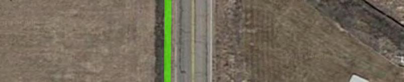
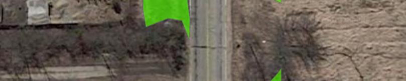
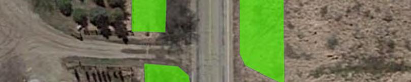
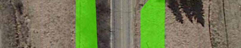
1 APPROVED JURISDICTIONAL DETERMINATION FORM U.S. Army Corps of Engineers This form should be completed by following the instructions provided in Section IV of the JD Form Instructional Guidebook. SECTION I: BACKGROUND INFORMATION A. REPORT COMPLETION DATE FOR APPROVED JURISDICTIONAL DETERMINATION (JD): 07/13/2018 B. ST PAUL, MN DISTRICT OFFICE, FILE NAME, AND NUMBER: MVP MMJ; AJD for W2a C. PROJECT LOCATION AND BACKGROUND INFORMATION: State: Minnesota County/parish/borough: Hennepin City: Plymouth Center coordinates of site (lat/long in degree decimal format): Lat N, Long W. Universal Transverse Mercator: UTM Zone 15N Name of nearest waterbody: Elm Creek Name of watershed or Hydrologic Unit Code (HUC): Check if map/diagram of review area and/or potential jurisdictional areas is/are available upon request. Check if other sites (e.g., offsite mitigation sites, disposal sites, etc ) are associated with this action and are recorded on a different JD form. D. REVIEW PERFORMED FOR SITE EVALUATION (CHECK ALL THAT APPLY): Office (Desk) Determination. Date: July 5, 2018 Field Determination. Date(s): SECTION II: SUMMARY OF FINDINGS A. RHA SECTION 10 DETERMINATION OF JURISDICTION. There are no navigable waters of the U.S. within Rivers and Harbors Act (RHA) jurisdiction (as defined by 33 CFR part 329) in the review area. B. CWA SECTION 404 DETERMINATION OF JURISDICTION. There are no waters of the U.S. within Clean Water Act (CWA) jurisdiction (as defined by 33 CFR part 328) in the review area. 1. Waters of the U.S.: N/A 2. Non-regulated waters/wetlands (check if applicable): 1 Potentially jurisdictional waters and/or wetlands were assessed within the review area and determined to be not jurisdictional. Explain: The review area for this determination contains a roadside ditch labeled as W2a on the attached figures labeled MVP MMJ Troy Lane AJD Figures 1-3. W2a is a roadside ditch that was constructed in upland, it drains only uplands, and it does not carry a relatively permanent flow of water into waters of the U.S. (WoUS). Per the Rapanos decision, the evaluated ditch is not a WoUS because it is not a tributary and it does not have a significant nexus to traditionally navigable waters. This was confirmed by reviewing aerial photography, elevation data and the delienation report that was completed for the project corridor. SECTION III: CWA ANALYSIS A. TNWs AND WETLANDS ADJACENT TO TNWs: N/A B. CHARACTERISTICS OF TRIBUTARY (THAT IS NOT A TNW) AND ITS ADJACENT WETLANDS (IF ANY): N/A C. SIGNIFICANT NEXUS DETERMINATION: N/A D. DETERMINATIONS OF JURISDICTIONAL FINDINGS. THE SUBJECT WATERS/WETLANDS ARE (CHECK ALL THAT APPLY): N/A E. ISOLATED [INTERSTATE OR INTRA-STATE] WATERS, INCLUDING ISOLATED WETLANDS, THE USE, DEGRADATION OR DESTRUCTION OF WHICH COULD AFFECT INTERSTATE COMMERCE, INCLUDING ANY SUCH WATERS (CHECK ALL THAT APPLY): N/A F. NON-JURISDICTIONAL WATERS, INCLUDING WETLANDS (CHECK ALL THAT APPLY): 1 Supporting documentation is presented in Section III.F.
2 If potential wetlands were assessed within the review area, these areas did not meet the criteria in the 1987 Corps of Engineers Wetland Delineation Manual and/or appropriate Regional Supplements. Review area included isolated waters with no substantial nexus to interstate (or foreign) commerce. Prior to the Jan 2001 Supreme Court decision in SWANCC, the review area would have been regulated based solely on the Migratory Bird Rule (MBR). Waters do not meet the Significant Nexus standard, where such a finding is required for jurisdiction. Explain: Other (explain, if not covered above): See Section II.B.2, above. Provide acreage estimates for non-jurisdictional waters in the review area, where the sole potential basis of jurisdiction is the MBR factors (i.e., presence of migratory birds, presence of endangered species, use of water for irrigated agriculture), using best professional judgment (check all that apply): Non-wetland waters (i.e., rivers, streams): linear feet width (ft). Lakes/ponds: acres. Other non-wetland waters: acres. List type of aquatic resource:. Wetlands: acres. Provide acreage estimates for non-jurisdictional waters in the review area that do not meet the Significant Nexus standard, where such a finding is required for jurisdiction (check all that apply): Non-wetland waters (i.e., rivers, streams): linear feet, width (ft). Lakes/ponds: acres. Other non-wetland waters: acres. List type of aquatic resource:. Wetlands: acres. SECTION IV: DATA SOURCES. A. SUPPORTING DATA. Data reviewed for JD (check all that apply - checked items shall be included in case file and, where checked and requested, appropriately reference sources below): Maps, plans, plots or plat submitted by or on behalf of the applicant/consultant: Troy Lane Wetland Delineation Report, submitted December 06, Data sheets prepared/submitted by or on behalf of the applicant/consultant. Office concurs with data sheets/delineation report. Office does not concur with data sheets/delineation report. Data sheets prepared by the Corps: Corps navigable waters study: U.S. Geological Survey Hydrologic Atlas: USGS NHD data. USGS 8 and 12 digit HUC maps. U.S. Geological Survey map(s). Cite scale & quad name: 1:24K Hamel USDA Natural Resources Conservation Service Soil Survey. Citation: National wetlands inventory map(s). Cite name: FWS NWI and MnDNR NWI State/Local wetland inventory map(s): FEMA/FIRM maps: 100-year Floodplain Elevation is: (National Geodectic Vertical Datum of 1929) Photographs: Aerial (Name & Date): FSA aerials or Other (Name & Date): Previous determination(s). File no. and date of response letter: Applicable/supporting case law: Applicable/supporting scientific literature: Other information (please specify): B. ADDITIONAL COMMENTS TO SUPPORT JD: N/A 2
3 MMJ, AJD Figure Troy Lane Reconstruction Figure 1: Location Map March, nd Ave N Wayzata Meadow Ridge Elementary CSAH 47 Lawndale Lane N Troy Lane N 56th Pl N Map Document: H:\PLYM\C \GIS\ESRI\Wetland Permit\Maps\115271_Fig1_Location.mxd Date Saved: 3/6/2018 4:26:25 PM?ØA@ CSAH 101 Project Location 0 1,500 Source: Google Satellite Imagery (2017), MNDOT Wayzata High School City of Plymouth Imagery 2018, DigitalGlobe, U.S. Geological Survey, USDA Farm Service Agency ^
4 MMJ, AJD Figure Troy Lane Reconstruction Figure 2: Project Layout March, 2018 BMI Wetland 1 (W1) OHWM2 OHWM1 Kjolhaug Wetland 1 (KW1) Map Document: H:\PLYM\C \GIS\ESRI\Wetland Permit\Maps\115271_Fig2_Project_Layout.mxd Date Saved: 3/8/2018 3:51:27 PM Construction Limits Proposed Multi-use Trail Proposed Storm Sewer Proposed Manhole Proposed Box Culvert Wetlands Delineated by Others BMI Delineated Wetlands Watercourse Source: Google Satellite Imagery (2017) BMI Wetland 2a (W2a) Incidental BMI Wetland 2b (W2b) BMI Wetland 2c (W2c) BMI Wetland 43 (W4) (W3) BMI Wetland 3 (W3) Imagery 2018, DigitalGlobe, U.S. Geological Survey, USDA Farm Service Agency


 KW1: Type 2")


5 MMJ, AJD Figure Troy Lane Reconstruction Figure 3: Proposed Impacts March 2018 W1: Type 1 Proposed Impacts: 47 sf W4: Type 2 Proposed Impacts: 0.10 ac OHWM 1 Proposed Impacts: 13 ft (57 sf) W2b: Type 2 OHWM 2 Proposed Impacts: 38 ft (662 sf) KW1: Type 2 Map Document: H:\PLYM\C \GIS\ESRI\Wetland Permit\Maps\115271_Fig3_Proposed_Impacts.mxd Date Saved: 3/8/2018 3:52:27 PM Construction Limits Proposed Multi-use Trail Proposed Storm Sewer Proposed Manhole Proposed Box Culvert Proposed Permanent Impacts Wetlands Delineated by Others BMI Delineated Wetlands Watercourse 0 50 Source: Google Satellite Imagery (2017) W2a: W2a: Type 2 Type - Incidental 2 W4: Type 2 W3: Type 1 Proposed Impacts: 0.02 ac Imagery 2018, DigitalGlobe, U.S. Geological Survey
APPROVED JURISDICTIONAL DETERMINATION FORM U.S. Army Corps of Engineers
 APPROVED JURISDICTIONAL DETERMINATION FORM U.S. Army Corps of Engineers This form should be completed by following the instructions provided in Section IV of the JD Form Instructional Guidebook. SECTION
APPROVED JURISDICTIONAL DETERMINATION FORM U.S. Army Corps of Engineers
 APPROVED JURISDICTIONAL DETERMINATION FORM U.S. Army Corps of Engineers This form should be completed by following the instructions provided in Section IV of the JD Form Instructional Guidebook. SECTION
APPROVED JURISDICTIONAL DETERMINATION FORM U.S. Army Corps of Engineers
 APPROVED JURISDICTIONAL DETERMINATION FORM U.S. Army Corps of Engineers This form should be completed by following the instructions provided in Section IV of the JD Form Instructional Guidebook. SECTION
APPROVED JURISDICTIONAL DETERMINATION FORM U.S. Army Corps of Engineers
 APPROVED JURISDICTIONAL DETERMINATION FORM U.S. Army Corps of Engineers This form should be completed by following the instructions provided in Section IV of the JD Form Instructional Guidebook. SECTION
APPROVED JURISDICTIONAL DETERMINATION FORM U.S. Army Corps of Engineers
 APPROVED JURISDICTIONAL DETERMINATION FORM U.S. Army Corps of Engineers This form should be completed by following the instructions provided in Section IV of the JD Form Instructional Guidebook. SECTION
APPROVED JURISDICTIONAL DETERMINATION FORM U.S. Army Corps of Engineers
 APPROVED JURISDICTIONAL DETERMINATION FORM U.S. Army Corps of Engineers This form should be completed by following the instructions provided in Section IV of the JD Form Instructional Guidebook. SECTION
APPROVED JURISDICTIONAL DETERMINATION FORM U.S. Army Corps of Engineers
 APPROVED JURISDICTIONAL DETERMINATION FORM U.S. Army Corps of Engineers This form should be completed by following the instructions provided in Section IV of the JD Form Instructional Guidebook. SECTION
APPROVED JURISDICTIONAL DETERMINATION FORM U.S. Army Corps of Engineers
 APPROVED JURISDICTIONAL DETERMINATION FORM U.S. Army Corps of Engineers This form should be completed by following the instructions provided in Section IV of the JD Form Instructional Guidebook. SECTION
APPROVED JURISDICTIONAL DETERMINATION FORM U.S. Army Corps of Engineers
 APPROVED JURISDICTIONAL DETERMINATION FORM U.S. Army Corps of Engineers This form should be completed by following the instructions provided in Section IV of the JD Form Instructional Guidebook. SECTION
APPROVED JURISDICTIONAL DETERMINATION FORM U.S. Army Corps of Engineers
 APPROVED JURISDICTIONAL DETERMINATION FORM U.S. Army Corps of Engineers This form should be completed by following the instructions provided in Section IV of the JD Form Instructional Guidebook. SECTION
APPROVED JURISDICTIONAL DETERMINATION FORM U.S. Army Corps of Engineers
 APPROVED JURISDICTIONAL DETERMINATION FORM U.S. Army Corps of Engineers SECTION I: BACKGROUND INFORMATION A. REPORT COMPLETION DATE FOR APPROVED JURISDICTIONAL DETERMINATION (JD): November 3, 06 B. DISTRICT
MVP WMS, George Schorr
 APPROVED JURISDICTIONAL DETERMINATION FORM U.S. Army Corps of Engineers This form should be completed by following the instructions provided in Section IV of the JD Form Instructional Guidebook. SECTION
APPROVED JURISDICTIONAL DETERMINATION FORM U.S. Army Corps of Engineers
 APPROVED JURISDICTIONAL DETERMINATION FORM U.S. Army Corps of Engineers This form should be completed by following the instructions provided in Section IV of the JD Form Instructional Guidebook. SECTION
APPROVED JURISDICTIONAL DETERMINATION FORM U.S. Army Corps of Engineers
 APPROVED JURISDICTIONAL DETERMINATION FORM U.S. Army Corps of Engineers This form should be completed by following the instructions provided in Section IV of the JD Form Instructional Guidebook. SECTION
APPROVED JURISDICTIONAL DETERMINATION FORM U.S. Army Corps of Engineers
 APPROVED JURISDICTIONAL DETERMINATION FORM U.S. Army Corps of Engineers This form should be completed by following the instructions provided in Section IV of the JD Form Instructional Guidebook: SECTION
APPROVED JURISDICTIONAL DETERMINATION FORM U.S. Army Corps of Engineers
 APPROVED JURISDICTIONAL DETERMINATION FORM U.S. Army Corps of Engineers This form should be completed by following the instructions provided in Section IV of the JD Form Instructional Guidebook. SECTION
APPROVED JURISDICTIONAL DETERMINATION FORM U.S. Army Corps of Engineers
 APPROVED JURISDICTIONAL DETERMINATION FORM U.S. Army Corps of Engineers This form should be completed by following the instructions provided in Section IV of the JD Form Instructional Guidebook. SECTION
APPROVED JURISDICTIONAL DETERMINATION FORM U.S. Army Corps of Engineers
 APPROVED JURISDICTIONAL DETERMINATION FORM U.S. Army Corps of Engineers This form should be completed by following the instructions provided in Section IV of the JD Form Instructional Guidebook. SECTION
DRY LAND APPROVED JURISDICTIONAL DETERMINATION FORM 1 U.S.
 DRY LAND APPROVED JURISDICTIONAL DETERMINATION FORM 1 U.S. Army Corps of Engineers This form should be completed by following the instructions provided in Section IV of the JD Form Instructional Guidebook.
APPROVED JURISDICTIONAL DETERMINATION FORM U.S. Army Corps of Engineers
 APPROVED JURISDICTIONAL DETERMINATION FORM U.S. Army Corps of Engineers This form should be completed by following the instructions provided in Section IV of the JD Form Instructional Guidebook. SECTION
APPROVED JURISDICTIONAL DETERMINATION FORM U.S. Army Corps of Engineers
 APPROVED JURISDICTIONAL DETERMINATION FORM U.S. Army Corps of Engineers This form should be completed by following the instructions provided in Section IV of the JD Form Instructional Guidebook. SECTION
Version TNW Only 1 of 3
 APPROVED JURISDICTIONAL DETERMINATION FORM U.S. Army Corps of Engineers SECTION I: BACKGROUND INFORMATION A. REPORT COMPLETION DATE FOR APPROVED JURISDICTIONAL DETERMINATION (JD): 3 Mar 2009. B. DISTRICT
APPROVED JURISDICTIONAL DETERMINATION FORM U.S. Army Corps of Engineers
 PPROVED JURISDICTIONL DETERMINTION FORM U.S. rmy Corps of Engineers This form should be completed by following the instructions provided in Section IV of the JD Form Instructional Guidebook. SECTION I:
APPROVED JURISDICTIONAL DETERMINATION FORM U.S. Army Corps of Engineers
 APPROVED JURISDICTIONAL DETERMINATION FORM U.S. Army Corps of Engineers This form should be completed by following the instructions provided in Section IV of the JD Form Instructional Guidebook. SECTION
APPROVED JURISDICTIONAL DETERMINATION FORM U.S. Army Corps of Engineers
 APPROVED JURISDICTIONAL DETERMINATION FORM U.S. Army Corps of Engineers SECTION I: BACKGROUND INFORMATION A. REPORT COMPLETION DATE FOR APPROVED JURISDICTIONAL DETERMINATION (JD): /4/06 B. DISTRICT OFFICE,
APPROVED JURISDICTIONAL DETERMINATION FORM U.S. Army Corps of Engineers
 APPROVED JURISDICTIONAL DETERMINATION FORM U.S. Army Corps of Engineers SECTION I: BACKGROUND INFORMATION A. REPORT COMPLETION DATE FOR APPROVED JURISDICTIONAL DETERMINATION (JD): August 9, 07 B. DISTRICT
SAN FRANCISCO DISTRICT INFORMATION REQUESTED FOR VERIFICATION OF CORPS JURISDICTION
 DEPARTMENT OF THE ARMY SAN FRANCISCO DISTRICT, U.S. ARMY CORPS OF ENGINEERS 1455 MARKET STREET SAN FRANCISCO, CALIFORNIA 94103-1398 SAN FRANCISCO DISTRICT INFORMATION REQUESTED FOR VERIFICATION OF CORPS
APPROVED JURISDICTIONAL DETERMINATION FORM U.S. Army Corps of Engineers
 APPROVED JURISDICTIONAL DETERMINATION FORM U.S. Army Corps of Engineers This form should be completed by following the instructions provided in Section N ofthe JD Form Instructional Guidebook. SECTION
Minimum Standards for Wetland Delineations
 Minimum Standards for Wetland Delineations Jason Gipson Chief, Utah/Nevada Regulatory Branch Sacramento District Regulatory Program Workshop 16 Mar 2016 US Army Corps of Engineers Delineation Report Minimum
Minimum Standards for Aquatic Resource Delineations
 Minimum Standards for Aquatic Resource Delineations Matt Wilson Senior Project Manager, Nevada-Utah Section Sacramento District Regulatory Program Workshop 31 May 2018 US Army Corps of Engineers Delineation
Information for File # MMJ; Trunk Highway (TH) 7 / Louisiana Ave. Interchange Project
 7 / Louisiana Ave. Interchange Project") Information for File # 2013-00531-MMJ; Trunk Highway (TH) 7 / Louisiana Ave. Interchange Project Applicant: City of St. Louis Park Corps Contact: Melissa Jenny Address: U.S. Army Corps of Engineers Attn:
Information for File # 2013-00531-MMJ; Trunk Highway (TH) 7 / Louisiana Ave. Interchange Project Applicant: City of St. Louis Park Corps Contact: Melissa Jenny Address: U.S. Army Corps of Engineers Attn:
Information for File MVP RMM
 Information for File MVP-2013-03320-RMM Applicant: City of St. Cloud Corps Contact: Ryan Malterud Address: 180 Fifth Street East, Suite 700, St. Paul, MN 55101 E-Mail: Ryan.M.Malterud@usace.army.mil Phone:
Wetlands in the Context of Road Projects
 September, 2011 Wetlands in the Context of Road Projects Goals of presentation include understanding: 1) need for accurate representation of wetlands and proposed impacts 2) time needed for concurrence
This form should be completed by following the instructions provided in Section IV of the JD Form Instructional Guidebook.
 APPROVED JURISDICTIONAL DETERMINATION FORM U.S. Army Corps of Engineers This form should be completed by following the instructions provided in Section IV of the JD Form Instructional Guidebook. SECTION
Information for File # ERH
 Information for File #2014-00931-ERH Applicant: Minnesota Department of Transportation, Scott Morgan Corps Contact: Eric Hanson Address: 180 5th Street East, Suite 700 St. Paul, MN 55101 E-Mail: eric.r.hanson@usace.army.mil
APPROVED JURISDICTIONAL DETERMINATION FORM U.S. Army Corps of Engineers
 APPROVED JURISDICTIONAL DETERMINATION FORM U.S. Army Corps of Engineers This form should be completed by follo,ving the instructions provided in Section IV of the JD Fann Instructional Guidebook. SECTION
AQUATIC RESOURCES DELINEATION REFRESHER
 AQUATIC RESOURCES DELINEATION REFRESHER James Jamie Robb Wetland Specialist, Office of the Chief 12 October 2016 US Army Corps of Engineers Ordinary High Water Mark (OHWM) How is the OHWM characterized
Electronic Submission Format Guide Large Noncoal (Industrial Minerals) Mine Permit Application (5600-PM-BMP0315)
 Mine Permit Application (5600-PM-BMP0315)") Electronic Submission Format Guide Large Noncoal (Industrial Minerals) Mine Permit Application (5600-PM-BMP0315) Module 1: Application Section A through Section I, the Application Checklist, and all narrative
Electronic Submission Format Guide Large Noncoal (Industrial Minerals) Mine Permit Application (5600-PM-BMP0315) Module 1: Application Section A through Section I, the Application Checklist, and all narrative
Electronic Submission Format Guide Anthracite Preparation Plant Permit Application
 Electronic Submission Format Guide Anthracite Preparation Plant Permit Application Module 1: Application Section A through Section J, the Application Checklist, and all narrative responses Act 67 / 68
Electronic Submission Format Guide Bituminous Coal Surface Mine Permit Application (5600-PM-BMP0311)
") Electronic Submission Format Guide Bituminous Coal Surface Mine Permit Application (5600-PM-BMP0311) Module 1: Application Section A through Section J, the Application Checklist, and all narrative responses.
Electronic Submission Format Guide Bituminous Coal Surface Mine Permit Application (5600-PM-BMP0311) Module 1: Application Section A through Section J, the Application Checklist, and all narrative responses.
Template for Sediment and Erosion Control Plan General Instructions. Section Instructions
 Template for Sediment and Erosion Control Plan General Instructions Introduction: Soil erosion and sediment deposition from farmlands can contribute to degraded surface water quality. Sediment delivery
(b)(5) deliberative process
(5) deliberative process") -----Original Message----- From: Jensen, Stacey M CIV USARMY CEHQ (US) Sent: Tuesday, September 05, 2017 1:00 PM To: 'Goodin, John' Cc: Eisenberg, Mindy ;
-----Original Message----- From: Jensen, Stacey M CIV USARMY CEHQ (US) Sent: Tuesday, September 05, 2017 1:00 PM To: 'Goodin, John' Cc: Eisenberg, Mindy ;
Required Documents. Title: Number: AEP Administration 2017 No. 1. Provincial Wetlands and Water Boundaries Section. Effective Date: September 1, 2017
 Title: Number: Program Name: Provincial Wetlands and Water Boundaries Section Effective Date: September 1, 2017 This document was updated on: August 25, 2017 The Provincial Wetlands and Water Boundaries
McHenry County Property Search Sources of Information
 Disclaimer: The information in this system may contain inaccuracies or typographical errors. The information in this system is a digital representation of information derived from original documents; as
Template for Sediment and Erosion Control Plan General Instructions
 Template for Sediment and Erosion Control Plan General Instructions Introduction: Soil erosion and sediment deposition from farmlands can contribute to degraded surface water quality. Sediment delivery
Land Use MTRI Documenting Land Use and Land Cover Conditions Synthesis Report
 Colin Brooks, Rick Powell, Laura Bourgeau-Chavez, and Dr. Robert Shuchman Michigan Tech Research Institute (MTRI) Project Introduction Transportation projects require detailed environmental information
² 2015 Program Year. Farm Tract McLeod County, Minnesota 1:4, NHEL NHEL
 United States Department of Agriculture McLeod County, Minnesota Farm 5125 #* 2 3.65 NHEL Tract 2762 1 33.19 NHEL ² 2015 Program Year Map Created November 06, 2014 Common Land Unit Cropland Non-cropland
Exhibit A Description of Services Section 37 Floodplain Storage Design
 Exhibit A Description of Services Section 37 Floodplain Storage Design Singhofen & Associates, Inc. (SAI, Consultant) is pleased to present this scope of services to the City of Palm Coast Engineering
December 16, Mr. Lee Hughes Southwest Florida Water Management District Tampa Service Office 7601 Highway 301 North Tampa, FL 33637
 December 16, 2015 Mr. Lee Hughes Southwest Florida Water Management District Tampa Service Office 7601 Highway 301 North Tampa, FL 33637 RE: Response to SWFWMD Supplemental Information Request Dear Mr.
Wetland Mapping & Functional Assessment Canadian River Watershed New Mexico. Association of State Wetland Managers
 Wetland Mapping & Functional Assessment Canadian River Watershed New Mexico Association of State Wetland Managers November, 2012 Approach for this project based on: EPA 2006 Document: Application of Elements
Special Public Notice
 Special Public Notice Applicability: General Public Date: June 3, 2014 The purpose of this public notice is to inform you of existing guidance and policy contained in Regulatory Guidance Letter 05-04 concerning
Section 4: Model Development and Application
 Section 4: Model Development and Application The hydrologic model for the Wissahickon Act 167 study was built using GIS layers of land use, hydrologic soil groups, terrain and orthophotography. Within
Location Restrictions Certification Report NIPSCO Michigan City Generating Station Boiler Slag Pond
 Location Restrictions Certification Report NIPSCO Michigan City Generating Station Boiler Slag Pond Pursuant to: 40 CFR 257.60 40 CFR 257.61 40 CFR 257.62 40 CFR 257.63 40 CFR 257.64 Submitted to: Northern
MEMORANDUM FOR SWG
 MEMORANDUM FOR SWG-2007-1623 Subject: Jurisdictional Determination (JD) for SWG-2007-1623 on Interdunal Wetlands Adjacent to Traditional Navigable Waters (TNWs) Summary The U.S. Environmental Protection
LAKE SURVEY REPORT. Fisheries Management. DOW Number: Survey ID Date: 07/31/2017. Lake Identification. Lake Location. Legal Descriptions
 Fisheries Management LAKE SURVEY REPORT Lake Name: Kroon Survey Type: Targeted Survey DOW Number: 13-0013-00 Survey ID Date: 07/31/2017 Lake Identification Alternate Lake Name: N/A Primary Lake Class ID:
McHenry County Property Search Sources of Information
 Disclaimer: The information in this system may contain inaccuracies or typographical errors. The information in this system is a digital representation of information derived from original documents; as
Create A Watershed Profile
 Name Date Follow the steps below with Chesapeake Bay FieldScope to create a watershed profile for your location. Part 1. Take a trip down your tributaries. Create A Watershed Profile 1. Find your field
FOR PROJECTS INITIATED AFTER NOVEMBER 1, 2008 ITEM 716 EMBANKMENT EARTH OUTLET SEDIMENT TRAP
 AFTER NOVEMBER 1, 2008 ITEM 716 EMBANKMENT EARTH OUTLET SEDIMENT TRAP 716.1 Description. This work shall consist of furnishing, installing, maintaining, and removing temporary erosion protection and sediment
Appendix C. Questionnaire Summary of Responses Geographic Information Systems
 Appendix C Questionnaire Summary of Responses Geographic Information Systems 1. Is your agency using or planning use of GIS for: a. general mapping (e.g. highway routes, political boundaries, etc.) b.
YELLOWSTONE RIVER FLOOD STUDY REPORT TEXT
 YELLOWSTONE RIVER FLOOD STUDY REPORT TEXT TECHNICAL REPORT Prepared for: City of Livingston 411 East Callender Livingston, MT 59047 Prepared by: Clear Creek Hydrology, Inc. 1627 West Main Street, #294
In order to give all interested parties an opportunity to express their views
 PUBLIC NOTI C E CHARLESTON DISTRICT CORPS OF ENGINEERS 69A Hagood Avenue Charleston South Carolina 29403-5107 REGULATORY DIVISION December 5 2012 Refer to: PIN # SAC-2012-00851 Pursuant to Sections 401
National Register of Historic Places Registration Form
 United States Department of the Interior National Park Service National Register of Historic Places Registration Form This form is for use in nominating or requesting determinations for individual properties
CRUM RANCH AREA MAP YOLO COUNTY, California, AC +/-
 CRUM RANCH AREA MAP YOLO COUNTY, California, 235.59 AC +/- Map data 2016 Google Imagery 2016, CAPCOG, DigitalGlobe, Texas Orthoimagery Program, U.S. Geological Survey, USDA Farm Service Agency Boundary
Improvement of the National Hydrography Dataset for Parts of the Lower Colorado Region and Additional Areas of Importance to the DLCC
 Improvement of the National Hydrography Dataset for Parts of the Lower Colorado Region and Additional Areas of Importance to the DLCC Carlos Reyes-Andrade California State University, Northridge September
Hydric Rating by Map Unit Harrison County, Mississippi. Web Soil Survey National Cooperative Soil Survey
 89 9' 7'' W 89 8' 38'' W 30 34' 13'' N 30 33' 57'' N 3383480 3383560 3383640 3383720 3383800 3383880 3383960 293640 293720 293800 293880 293960 294040 294120 294200 294280 294360 3383480 3383560 3383640
National Hydrography Dataset (NHD) Update Project for US Forest Service Region 3
 Update Project for US Forest Service Region 3") National Hydrography Dataset (NHD) Update Project for US Forest Service Region 3 Allison Moncada California State University, Northridge February 2017 July 2017 Advisor: Joel Osuna Center for Geographical
National Hydrography Dataset (NHD) Update Project for US Forest Service Region 3 Allison Moncada California State University, Northridge February 2017 July 2017 Advisor: Joel Osuna Center for Geographical
CALIFORNIA AGRICULTURAL PR OPERTIES, IN C. GALE RANCH
 CALIFORNIA AGRICULTURAL PR OPERTIES, IN C. GALE RANCH LOCATION: The Ranch is located 6 Yi miles west of the City of Davis on the northwest corner of County Roads 29A and 92E in Yolo County. SIZE: 368.64
NEWS RELEASE UNDER SECTION 404 OF THE CLEAN WATER ACT (33 USC 1344) ACTION NUMBER SPA ABQ
 ACTION NUMBER SPA ABQ") PUBLIC NOTICE Public Notice Issue Date: //6/07 Albuquerque District Comments due: /6/08 NEWS RELEASE UNDER SECTION 0 OF THE CLEAN WATER ACT ( USC ) ACTION NUMBER SPA-06-00-ABQ BANK STABILIZATION ALONG
PUBLIC NOTICE Public Notice Issue Date: //6/07 Albuquerque District Comments due: /6/08 NEWS RELEASE UNDER SECTION 0 OF THE CLEAN WATER ACT ( USC ) ACTION NUMBER SPA-06-00-ABQ BANK STABILIZATION ALONG
APPLICATION TO AMEND THE FUTURE LAND USE MAP (FLUM) SMALL SCALE
 SMALL SCALE") DEPARTMENT OF DEVELOPMENT & PLANNING 825 Ohio Avenue - Lynn Haven, FL 32444 (850) 265-2961 - (850) 265-3478 APPLICATION TO AMEND THE FUTURE LAND USE MAP (FLUM) SMALL SCALE Deadline to submit is 30 days
DEPARTMENT OF DEVELOPMENT & PLANNING 825 Ohio Avenue - Lynn Haven, FL 32444 (850) 265-2961 - (850) 265-3478 APPLICATION TO AMEND THE FUTURE LAND USE MAP (FLUM) SMALL SCALE Deadline to submit is 30 days
Distinct landscape features with important biologic, hydrologic, geomorphic, and biogeochemical functions.
 1 Distinct landscape features with important biologic, hydrologic, geomorphic, and biogeochemical functions. Have distinguishing characteristics that include low slopes, well drained soils, intermittent
Pierce Cedar Creek Institute GIS Development Final Report. Grand Valley State University
 Pierce Cedar Creek Institute GIS Development Final Report Grand Valley State University Major Goals of Project The two primary goals of the project were to provide Matt VanPortfliet, GVSU student, the
Esri Image & Mapping Forum 9 July 2017 Geiger-Mode for Conservation Planning & Design by USDA NRCS NGCE
 Esri Image & Mapping Forum 9 July 2017 Geiger-Mode for Conservation Planning & Design by USDA NRCS NGCE For over 75 years, the Natural Resources Conservation Service has been a pioneer in conservation,
Elevation (ft) Slope ( ) County CONDITION CATEGORY. Parameter Natural Condition Slightly impacted Moderately Impacted Heavily Impacted
 Slope ( ) County CONDITION CATEGORY. Parameter Natural Condition Slightly impacted Moderately Impacted Heavily Impacted") Version: 8/25/14 Meadow Name Date : / / MM DD YYYY GPS Location:. N. W GPS Datum (e.g., WGS 84, NAD 27) Elevation (ft) Slope ( ) County Watershed (HUC8) Landowner USGS Quad Name Observers: 7.5 or 15 (circle
Version: 8/25/14 Meadow Name Date : / / MM DD YYYY GPS Location:. N. W GPS Datum (e.g., WGS 84, NAD 27) Elevation (ft) Slope ( ) County Watershed (HUC8) Landowner USGS Quad Name Observers: 7.5 or 15 (circle
Huron Creek Watershed 2005 Land Use Map
 Huron Creek Watershed 2005 Land Use Map Created By: Linda Kersten, 12/20/06 Created For: MTU Introduction to GIS Class (FW 5550) The Huron Creek Watershed Advisory Committee Michigan Technological University,
Louisiana Transportation Engineering Conference. Monday, February 12, 2007
 Louisiana Transportation Engineering Conference Monday, February 12, 2007 Agenda Project Background Goal of EIS Why Use GIS? What is GIS? How used on this Project Other site selection tools I-69 Corridor
BACKGROUND AND PROJECT DESCRIPTION
 June 7, 2017 Applicant: Murdock Builders Location: Approximately 600 West 1200 North Prepared by: Brian Tucker Public Hearing Item: Yes Zone: A-2, RA-2 ATTACHMENTS 1. Findings for Decision. 2. Resolution
Exhibit RMP-4. Foote Creek Geology and Topography
 Exhibit RMP-4 Foote Creek Geology and Topography Memorandum To: From: CC: Travis Brown, PacifiCorp Daria Drago, P.E., PMP Dr. Deb Luchsinger Date: January 9, 2019 Re: Foote Creek Rim 1 - Geologic Conditions
Chapter 1 Overview of Maps
 Chapter 1 Overview of Maps In this chapter you will learn about: Key points when working with maps General types of maps Incident specific maps Map legend and symbols Map sources A map is a navigational
BUNCOMBE COUNTY NORTH CAROLINA
 PROJECT SITE ² 0 0. 75 1. 5 LOCATION MAP MARCH 2018 2. 25 3 Mil es AID: PROJECT # 2018-01122 18.05301 Sheet 1 of 7 Sources: Esri, HERE, DeLorme, USGS, Intermap, INCREMENT P, NRCan, Esri Japan, METI, Esri
A Comprehensive Inventory of the Number of Modified Stream Channels in the State of Minnesota. Data, Information and Knowledge Management.
 A Comprehensive Inventory of the Number of Modified Stream Channels in the State of Minnesota Data, Information and Knowledge Management Glenn Skuta Environmental Analysis and Outcomes Division Minnesota
Wetland Delineation. Proposed CVS Pharmacy 9th Street and US Highway 98 (Avenue E) Apalachicola, Franklin County, Florida
 Apalachicola, Franklin County, Florida") Wetland Delineation Proposed CVS Pharmacy 9th Street and US Highway 98 (Avenue E) Apalachicola, Franklin County, Florida August 11, 2016 Terracon Project No. 49167572 Prepared for: Halstead Montgomery,
Wetland Delineation Proposed CVS Pharmacy 9th Street and US Highway 98 (Avenue E) Apalachicola, Franklin County, Florida August 11, 2016 Terracon Project No. 49167572 Prepared for: Halstead Montgomery,
Wetlands and Riparian Mapping Framework Technical Meeting
 Wetlands and Riparian Mapping Framework Technical Meeting Meghan Burns Landscape Ecologist Linda Vance Senior Ecologist Why wetland and riparian mapping? Preliminary site assessment for the presence of
What Do You See? FOR 274: Forest Measurements and Inventory. Area Determination: Frequency and Cover
 What Do You See? Message of the Day: Many options exist to determine the size, area, or extent of a feature on a landscape FOR 274: Forest Measurements and Inventory Lecture 7: Measures of Land Area Frequency
ILLINOIS RIVER BASIN RESTORATION COMPREHENSIVE PLAN WITH INTEGRATED ENVIRONMENTAL ASSESSMENT APPENDIX B
 ILLINOIS RIVER BASIN RESTORATION COMPREHENSIVE PLAN WITH INTEGRATED ENVIRONMENTAL ASSESSMENT APPENDIX B SYSTEM ECOLOGY ILLINOIS RIVER BASIN RESTORATION COMPREHENSIVE PLAN WITH INTEGRATED ENVIRONMENTAL
Web Soil Survey National Cooperative Soil Survey
 121 52' 18'' W Irrigated Capability Class Sutter County, California () 121 51' 49'' W 597600 597700 597800 597900 598000 598100 598200 39 6' 27'' N 39 6' 27'' N 39 5' 57'' N 4328400 4328500 4328600 4328700
3.11 Floodplains Existing Conditions
 Other stormwater control practices may be needed to mitigate water quality impacts. In addition to detention facilities, other practices such as vegetated basins/buffers, infiltration basins, and bioswales
Drainage Analysis. Appendix F
 Drainage Analysis Appendix F Golden View Drive Elizabeth Street LMORE CREEK Ricky Road Rabbit Creek Road LITTLE RABBIT CREEK East 156th Avenue MOA Project #10-026 Golden View Drive Intersection
GOAL 7 AREAS SUBJECT TO NATURAL DISASTERS AND HAZARDS. To protect life and property from natural disasters and hazards.
 GOAL 7 AREAS SUBJECT TO NATURAL DISASTERS AND HAZARDS A. GOALS: To protect life and property from natural disasters and hazards. B. POLICIES: 1. Floodplains shall be maintained as natural drainage-ways.
Information Paper. Kansas City District. Missouri River Fish and Wildlife Mitigation Project Jim and Olivia Hare Wildlife Area, MO
 City District Information Paper River Fish and Wildlife Mitigation Project Jim and Olivia Hare Wildlife Area, MO Riverine habitat created in 2004/2005 by modifying existing river structures along the banks,
Summary Description Municipality of Anchorage. Anchorage Coastal Resource Atlas Project
 Summary Description Municipality of Anchorage Anchorage Coastal Resource Atlas Project By: Thede Tobish, MOA Planner; and Charlie Barnwell, MOA GIS Manager Introduction Local governments often struggle
Cripps Ranch 76+/- Acres Orchard Development Opportunity Dixon, CA. Presented By:
 Cripps Ranch 76+/- Acres Orchard Development Opportunity Dixon, CA Presented By: Cripps Ranch 76+/- Acres Orchard Development Opportunity Dixon, CA Location: This property is located at 5663 Dally Road
EAGLES NEST AND PIASA ISLANDS
 EAGLES NEST AND PIASA ISLANDS HABITAT REHABILITATION AND ENHANCEMENT PROJECT MADISON AND JERSEY COUNTIES, ILLINOIS ENVIRONMENTAL MANAGEMENT PROGRAM ST. LOUIS DISTRICT FACT SHEET I. LOCATION The proposed
Custom Soil Resource Report for Victoria County, Texas
 United States Department of Agriculture Natural Resources Conservation Service A product of the National Cooperative Soil Survey, a joint effort of the United States Department of Agriculture and other
Introducing Iowa StreamStats Version 4, a Redesign of the USGS Application for Estimating Streamflow Stats
 Introducing Iowa StreamStats Version 4, a Redesign of the USGS Application for Estimating Streamflow Stats Presented at the 2016 Iowa Water Conference Ames, IA March 24, 2016 by David Eash U.S. Geological
JOURNAL OF ENVIRONMENTAL HYDROLOGY The Electronic Journal of the International Association for Environmental Hydrology VOLUME
 JOURNAL OF ENVIRONMENTAL HYDROLOGY The Electronic Journal of the International Association for Environmental Hydrology VOLUME 18 2010 REDUCED CHANNEL CONVEYANCE ON THE WICHITA RIVER AT WICHITA FALLS, TEXAS,
Saganashkee Slough - McMahon Woods Section 506 Great Lakes Fishery & Ecosystem Restoration Study
 2015 Saganashkee Slough - McMahon Woods Section 506 Great Lakes Fishery & Ecosystem Restoration Study Appendix B Civil Design USACE Chicago District August 2015 TABLE OF CONTENTS INTRODUCTION... 3 General...
Defining the Limit of Regulated Areas. C.1 Defining the River or Stream Flood Hazard 138. C.2 Defining the River or Stream Erosion Hazard 139
 C.1 Defining the River or Stream Flood Hazard 138 C.2 Defining the River or Stream Erosion Hazard 139 C.3 Defining Watercourses 141 C.4 Defining the Lake Ontario Shoreline Flood, Erosion and Dynamic Beach
ARMSTRONG COUNTY, PA
 ARMSTRONG COUNTY, PA Revised Preliminary DFIRM Mapping March 31, 2013 Kevin Donnelly, P.E., CFM GG3, Greenhorne & O Mara, Inc. Presentation Agenda Armstrong County DFIRM Overview - June 25, 2010 DFIRM
The Ordinary High Water Mark: Concepts, Research, and Applications. Matthew K. Mersel March 20, 2013
 The Ordinary High Water Mark: Concepts, Research, and Applications Matthew K. Mersel March 20, 2013 Under Section 404 of the Clean Water Act, the OHWM defines the lateral limits of Federal jurisdiction
ADMINISTRATION DEPARTMENT Land Management Information Center. An Inventory of Its Records
 MINNESOTA HISTORICAL SOCIETY Minnesota State Archives ADMINISTRATION DEPARTMENT Land Management Information Center An Inventory of Its Records OVERVIEW OF THE RECORDS Agency: Series Title: Land Management