High School World History Cycle 2 Week 2 Lifework
|
|
|
- Rodney Stafford
- 5 years ago
- Views:
Transcription


1 Name: Advisory: Period: High School World History Cycle 2 Week 2 Lifework This packet is due Monday, November 7 Complete and turn in on Friday for 10 points of EXTRA CREDIT! Lifework Assignment Complete on evening of None Regions Reading & Questions Regions: Cities & States Countries, and Continents Regions Scenarios Monday, October 31st Tuesday, November 1st Wednesday, November 2nd Thursday, November 3rd Friday, November 4th Please complete assignments with excellence using complete sentences, correct punctuation and capitalization. Ms. Bush: Ms. Wiedemann:
2

, almost all of them have strong ties to religion.")


3 Regions Reading A region is an area of land that has common features. A region can be defined by natural or artificial (human made) features. Language, government, or religion can define a region, as can forests, wildlife, or climate. Regions, large or small, are the basic units of geography. The Middle East is considered a political, environmental, and religious region that includes parts of Africa, Asia, and Europe. The region is in a hot, dry climate. Although the styles of government are varied (democracy in Israel and Syria, monarchy in Saudi Arabia), almost all of them have strong ties to religion. The region is where three of the world's major religions were founded: Christianity, Judaism, and Islam. The Amazon River region in South America is the area surrounding the Amazon River, which runs through the northern part of the continent, including Brazil, Bolivia, Ecuador, and Peru. This region is characterized by warm temperatures, heavy rainfall, a large diversity of plant and animal species, and little human impact on the environment. Geographers also use regions to study prehistoric environments that no longer exist. Due to plate tectonics, or the movement of the Earth's crust, geographic regions are constantly being created and destroyed over time. Paleogeography is the study of these ancient environments. One paleogeographic region is Pangaea, the supercontinent that existed millions of years ago, during the Paleozoic and Mesozoic eras. The continents we know today split apart from the supercontinent of Pangaea.

4 Regions of the United States There are many different ways to divide the United States into regions. The Library of Congress lists 16, here are just a few below: East: All states east of the Mississippi River Middle West or Midwest: from the Rocky Mountains to the Allegheny Mountains; Illinois, Iowa, Indiana, Kansas, Michigan, Minnesota, Missouri, Nebraska, North Dakota, Ohio, South Dakota, Wisconsin Northeast: east of the Mississippi River, north of the Ohio and Potomac rivers: Connecticut, Delaware, District of Columbia, Illinois, Indiana, Maine, Maryland, Massachusetts, Michigan, New Hampshire, New Jersey, New York, Ohio, Pennsylvania, Rhode Island, Vermont, Wisconsin. Northwest: states between Lake Superior and the Pacific Ocean: Idaho, Iowa, Kansas, Minnesota, Missouri, Montana, Nebraska, North Dakota, Oregon, South Dakota, Washington, Wyoming. South: States south of the Mason-Dixon Line: Alabama, Arkansas, Florida, Georgia, Kentucky, Louisiana, Mississippi, North Carolina, Oklahoma, South Carolina, Tennessee, Texas, Virginia, West Virginia. Southwest: Arkansas, Arizona, California, Colorado, Nevada, New Mexico, Texas, Utah. West: All states west of the Mississippi River. Regions Reading Questions Directions: After reading about regions, answer the following questions with complete sentences. 1. What is a region? How can regions be characterized? 2. Regions are of geography. Examples of regions include: neighborhoods, cities, states, countries, and continents
5 3. What makes the Middle East such a unique region? Use examples from the text to support your answer. 4. What characteristics make the Amazon River region a region? Are they environmental/natural or human characteristics? Explain your answer. 5. How do geographers use plate tectonics to identify regions? What region is used as an example? 6. Which region is Missouri in?

6 Regions: Cities & States A city is a legally defined government and populated area. It has political power from the state and county. Local laws, regulations and policies are created and approved by the voters of the city and its representatives/ leaders. Cities can be both big and small but vary in size due to population and the amount of land the city owns/has. States are political areas of land of the United States of America, with different names and similar governments. Countries can also be called states, but for this example we are looking at countries like the United States, Canada, and Brazil that divide their countries into pieces of land, or territories called states. In the U.S. there are 50 states, which are bound together. Each state has some power over the decisions it makes for the people who live in its state, or defined geographic territory. So, states are made up of cities, towns and counties (counties have both cities and towns inside of it) and the U.S. is made up of 50 states. For example: City, State City, State City, State St. Louis, MO Chicago, IL New York, NY Population 318,416 people 2,700,000 people 8, 550, 405 people Size in square miles miles 234 miles miles 1. Circle the city of St. Louis on the map to the left. 2. What is a city? 3. How is a city different from a state? Explain the relationship between them. 4. Making connections: Is St. Louis a region? Why or why not?

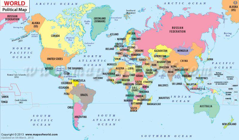
7 Countries and Continents: The seven continents are the seven main land areas on Earth, which include: North America, South America, Europe, Asia, Africa, Australia, and Antarctica. Some are joined to each other, like Europe to Asia, Asia to Africa, and North America to South America. Other continents like Australia and Antarctica are completely surrounded by water. Some continents have a lot of countries, but others have a few. A continent is home to many different countries. Antarctica is so cold no one truly lives there, with the exception for scientific research. Australia is the only continent to also be a country (the surrounding countries of the South Pacific Ocean region are lumped in with Australia). All other continents have at least 10 or more as you can see on the chart below. For example, the United States, Mexico, and Canada are in North America with 20 other smaller countries. Countries create political borders/ territories (separation) of the land of its continent. A border is an invisible line marking territory between places. In some areas borders are physical, actual dividers such as walls or fences. Continent Africa Antarctica Asia Number of Countries & Info 54 countries. It is the hottest continent and home of the world's largest desert, the Sahara, occupying the 25% of the total area of Africa. Few claims by other countries, NOT A COUNTRY just a continent 50 countries, and it is the most populated continent, the 60% of the total population of the Earth live here Australia 14 countries. It is the least populated continent after Antarctica, only 0.3% of the total Earth population live here. Europe North America South America 51 countries. It is the most developed economically continent with the European Union as the biggest economic and political union in the world. 23 countries led by the USA as the largest economy in the world 12 countries. Here is located the largest forest, the Amazon rainforest, which covers 30% of the South America total area.
8 1. What is a continent? 2. What is the difference between a continent and a country? 3. Which continent has the fewest countries? Why do they have the fewest? 4. Which continent has the most countries? PREDICT why does this continent have the most? 5. Select five countries from the map on the previous page and identify what continent they are on. a. Country: Continent: b. Country: Continent: c. Country: Continent: d. Country: Continent: e. Country: Continent:
9 Regions Scenarios Directions: Read each scenario and then identify the regions. Use the maps on the previous pages for help. 1. Jessica traveled to St. Louis, MO for a summer to work at a summer camp. She was from Cape Town, South Africa. Region Traveled from Traveled to City (may not have one) Country Continent 2. Rohaan is from Sri Lanka, an island country off of India, where he owns a coconut farm. He left his family farm to study biology at a university in Berlin, Germany. Region Traveled from Traveled to City (may not have one) Country Continent 3. Lisette is from Nouakchott, Mauritania and she traveling to Ulaanbaatar (capital city), Mongolia. Region Traveled from Traveled to City (may not have one) Country Continent
10
Preview: Making a Mental Map of the Region
 Preview: Making a Mental Map of the Region Draw an outline map of Canada and the United States on the next page or on a separate sheet of paper. Add a compass rose to your map, showing where north, south,
Challenge 1: Learning About the Physical Geography of Canada and the United States
 60ºN S T U D E N T H A N D O U T Challenge 1: Learning About the Physical Geography of Canada and the United States 170ºE 10ºW 180º 20ºW 60ºN 30ºW 1 40ºW 160ºW 50ºW 150ºW 60ºW 140ºW N W S E 0 500 1,000
A. Geography Students know the location of places, geographic features, and patterns of the environment.
 Learning Targets Elementary Social Studies Grade 5 2014-2015 A. Geography Students know the location of places, geographic features, and patterns of the environment. A.5.1. A.5.2. A.5.3. A.5.4. Label North
New Educators Campaign Weekly Report
 Campaign Weekly Report Conversations and 9/24/2017 Leader Forms Emails Collected Text Opt-ins Digital Journey 14,661 5,289 4,458 7,124 317 13,699 1,871 2,124 Pro 13,924 5,175 4,345 6,726 294 13,086 1,767
Correction to Spatial and temporal distributions of U.S. winds and wind power at 80 m derived from measurements
 JOURNAL OF GEOPHYSICAL RESEARCH, VOL. 109,, doi:10.1029/2004jd005099, 2004 Correction to Spatial and temporal distributions of U.S. winds and wind power at 80 m derived from measurements Cristina L. Archer
Standard Indicator That s the Latitude! Students will use latitude and longitude to locate places in Indiana and other parts of the world.
 Standard Indicator 4.3.1 That s the Latitude! Purpose Students will use latitude and longitude to locate places in Indiana and other parts of the world. Materials For the teacher: graph paper, globe showing
Additional VEX Worlds 2019 Spot Allocations
 Overview VEX Worlds 2019 Spot s Qualifying spots for the VEX Robotics World Championship are calculated twice per year. On the following table, the number in the column is based on the number of teams
Jakarta International School 6 th Grade Formative Assessment Graphing and Statistics -Black
 Jakarta International School 6 th Grade Formative Assessment Graphing and Statistics -Black Name: Date: Score : 42 Data collection, presentation and application Frequency tables. (Answer question 1 on
North American Geography. Lesson 2: My Country tis of Thee
 North American Geography Lesson 2: My Country tis of Thee Unit Overview: As students work through the activities in this unit they will be introduced to the United States in general, different regions
, District of Columbia
 State Capitals These are the State Seals of each state. Fill in the blank with the name of each states capital city. (Hint: You may find it helpful to do the word search first to refresh your memory.),
Grand Total Baccalaureate Post-Baccalaureate Masters Doctorate Professional Post-Professional
 s by Location of Permanent Home Address and Degree Level Louisiana Acadia 19 13 0 3 0 3 0 0 0 Allen 5 5 0 0 0 0 0 0 0 Ascension 307 269 2 28 1 6 0 1 0 Assumption 14 12 0 1 0 1 0 0 0 Avoyelles 6 4 0 1 0
Cooperative Program Allocation Budget Receipts Southern Baptist Convention Executive Committee October 2017
 Cooperative Program Allocation Budget Receipts October 2017 Cooperative Program Allocation Budget Current Current $ Change % Change Month Month from from Contribution Sources 2017-2018 2016-2017 Prior
Cooperative Program Allocation Budget Receipts Southern Baptist Convention Executive Committee October 2018
 Cooperative Program Allocation Budget Receipts October 2018 Cooperative Program Allocation Budget Current Current $ Change % Change Month Month from from Contribution Sources 2018-2019 2017-2018 Prior
Cooperative Program Allocation Budget Receipts Southern Baptist Convention Executive Committee May 2018
 Cooperative Program Allocation Budget Receipts May 2018 Cooperative Program Allocation Budget Current Current $ Change % Change Month Month from from Contribution Sources 2017-2018 2016-2017 Prior Year
Grand Total Baccalaureate Post-Baccalaureate Masters Doctorate Professional Post-Professional
 s by Location of Permanent Home Address and Degree Level Louisiana Acadia 26 19 0 6 1 0 0 0 0 Allen 7 7 0 0 0 0 0 0 0 Ascension 275 241 3 23 1 6 0 1 0 Assumption 13 12 0 1 0 0 0 0 0 Avoyelles 15 11 0 3
QF (Build 1010) Widget Publishing, Inc Page: 1 Batch: 98 Test Mode VAC Publisher's Statement 03/15/16, 10:20:02 Circulation by Issue
 Widget Publishing, Inc Page: 1 Batch: 98 Test Mode VAC Publisher's Statement 03/15/16, 10:20:02 Circulation by Issue") QF 1.100 (Build 1010) Widget Publishing, Inc Page: 1 Circulation by Issue Qualified Non-Paid Circulation Qualified Paid Circulation Individual Assoc. Total Assoc. Total Total Requester Group Qualified
QF 1.100 (Build 1010) Widget Publishing, Inc Page: 1 Circulation by Issue Qualified Non-Paid Circulation Qualified Paid Circulation Individual Assoc. Total Assoc. Total Total Requester Group Qualified
National Council for Geographic Education Curriculum & Instruction Committee Geography Club Submitted by: Steve Pierce
 National Council for Geographic Education Curriculum & Instruction Committee Geography Club Submitted by: Steve Pierce stevepierce@charter.net Ninth Month Activities Geography for Life: National Geography
Summary of Natural Hazard Statistics for 2008 in the United States
 Summary of Natural Hazard Statistics for 2008 in the United States This National Weather Service (NWS) report summarizes fatalities, injuries and damages caused by severe weather in 2008. The NWS Office
Meteorology 110. Lab 1. Geography and Map Skills
 Meteorology 110 Name Lab 1 Geography and Map Skills 1. Geography Weather involves maps. There s no getting around it. You must know where places are so when they are mentioned in the course it won t be
Abortion Facilities Target College Students
 Target College Students By Kristan Hawkins Executive Director, Students for Life America Ashleigh Weaver Researcher Abstract In the Fall 2011, Life Dynamics released a study entitled, Racial Targeting
Intercity Bus Stop Analysis
 by Karalyn Clouser, Research Associate and David Kack, Director of the Small Urban and Rural Livability Center Western Transportation Institute College of Engineering Montana State University Report prepared
Office of Budget & Planning 311 Thomas Boyd Hall Baton Rouge, LA Telephone 225/ Fax 225/
 Louisiana Acadia 20 17 3 0 0 0 Allen 2 2 0 0 0 0 Ascension 226 185 37 2 1 1 Assumption 16 15 1 0 0 0 Avoyelles 20 19 1 0 0 0 Beauregard 16 11 4 0 0 1 Bienville 2 2 0 0 0 0 Bossier 22 18 4 0 0 0 Caddo 91
OUT-OF-STATE 965 SUBTOTAL OUT-OF-STATE U.S. TERRITORIES FOREIGN COUNTRIES UNKNOWN GRAND TOTAL
 Report ID: USSR8072-V3 Page No. 1 Jurisdiction: ON-CAMPUS IL Southern Illinois University - Carb 1 0 0 0 Black Hawk College Quad-Cities 0 0 1 0 John A Logan College 1 0 0 0 Rend Lake College 1 0 0 0 Aurora
Crop Progress. Corn Mature Selected States [These 18 States planted 92% of the 2017 corn acreage]
![Crop Progress. Corn Mature Selected States [These 18 States planted 92% of the 2017 corn acreage]](/thumbs/89/98128758.jpg "Crop Progress. Corn Mature Selected States [These 18 States planted 92% of the 2017 corn acreage]") Crop Progress ISSN: 00 Released October, 0, by the National Agricultural Statistics Service (NASS), Agricultural Statistics Board, United s Department of Agriculture (USDA). Corn Mature Selected s [These
Crop Progress ISSN: 00 Released October, 0, by the National Agricultural Statistics Service (NASS), Agricultural Statistics Board, United s Department of Agriculture (USDA). Corn Mature Selected s [These
Osteopathic Medical Colleges
 Osteopathic Medical Colleges Matriculants by U.S. States and Territories Entering Class 0 Prepared by the Research Department American Association of Colleges of Osteopathic Medicine Copyright 0, AAM All
Multivariate Statistics
 Multivariate Statistics Chapter 3: Principal Component Analysis Pedro Galeano Departamento de Estadística Universidad Carlos III de Madrid pedro.galeano@uc3m.es Course 2017/2018 Master in Mathematical
Hourly Precipitation Data Documentation (text and csv version) February 2016
 February 2016") I. Description Hourly Precipitation Data Documentation (text and csv version) February 2016 Hourly Precipitation Data (labeled Precipitation Hourly in Climate Data Online system) is a database that gives
I. Description Hourly Precipitation Data Documentation (text and csv version) February 2016 Hourly Precipitation Data (labeled Precipitation Hourly in Climate Data Online system) is a database that gives
JAN/FEB MAR/APR MAY/JUN
 QF 1.100 (Build 1010) Widget Publishing, Inc Page: 1 Circulation Breakdown by Issue Qualified Non-Paid Qualified Paid Previous This Previous This Total Total issue Removals Additions issue issue Removals
Multivariate Statistics
 Multivariate Statistics Chapter 4: Factor analysis Pedro Galeano Departamento de Estadística Universidad Carlos III de Madrid pedro.galeano@uc3m.es Course 2017/2018 Master in Mathematical Engineering Pedro
Printable Activity book
 Printable Activity book 16 Pages of Activities Printable Activity Book Print it Take it Keep them busy Print them out Laminate them or Put them in page protectors Put them in a binder Bring along a dry
RELATIONSHIPS BETWEEN THE AMERICAN BROWN BEAR POPULATION AND THE BIGFOOT PHENOMENON
 RELATIONSHIPS BETWEEN THE AMERICAN BROWN BEAR POPULATION AND THE BIGFOOT PHENOMENON ETHAN A. BLIGHT Blight Investigations, Gainesville, FL ABSTRACT Misidentification of the American brown bear (Ursus arctos,
What Lies Beneath: A Sub- National Look at Okun s Law for the United States.
 What Lies Beneath: A Sub- National Look at Okun s Law for the United States. Nathalie Gonzalez Prieto International Monetary Fund Global Labor Markets Workshop Paris, September 1-2, 2016 What the paper
Club Convergence and Clustering of U.S. State-Level CO 2 Emissions
 Methodological Club Convergence and Clustering of U.S. State-Level CO 2 Emissions J. Wesley Burnett Division of Resource Management West Virginia University Wednesday, August 31, 2013 Outline Motivation
2005 Mortgage Broker Regulation Matrix
 2005 Mortgage Broker Regulation Matrix Notes on individual states follow the table REG EXEMPTIONS LIC-EDU LIC-EXP LIC-EXAM LIC-CONT-EDU NET WORTH BOND MAN-LIC MAN-EDU MAN-EXP MAN-EXAM Alabama 1 0 2 0 0
Office of Special Education Projects State Contacts List - Part B and Part C
 Office of Special Education Projects State Contacts List - Part B and Part C Source: http://www.ed.gov/policy/speced/guid/idea/monitor/state-contactlist.html Alabama Customer Specialist: Jill Harris 202-245-7372
Chapter. Organizing and Summarizing Data. Copyright 2013, 2010 and 2007 Pearson Education, Inc.
 Chapter 2 Organizing and Summarizing Data Section 2.1 Organizing Qualitative Data Objectives 1. Organize Qualitative Data in Tables 2. Construct Bar Graphs 3. Construct Pie Charts When data is collected
United States Geography Unit 1
 United States Geography Unit 1 I WANT YOU TO STUDY YOUR GEORGAPHY Name: Period: Due Date: Geography Key Terms Absolute Location: Relative Location: Demographic Map: Population Density: Sun-Belt: Archipelago:
MO PUBL 4YR 2090 Missouri State University SUBTOTAL-MO
 Report ID: USSR8072-V3 Page No. 1 Jurisdiction: ON-CAMPUS IL American Intercontinental Universit 0 0 1 0 Northern Illinois University 0 0 4 0 Southern Illinois Univ - Edwardsvil 2 0 2 0 Southern Illinois
extreme weather, climate & preparedness in the american mind
 extreme weather, climate & preparedness in the american mind Extreme Weather, Climate & Preparedness In the American Mind Interview dates: March 12, 2012 March 30, 2012. Interviews: 1,008 Adults (18+)
Office of Budget & Planning 311 Thomas Boyd Hall Baton Rouge, LA Telephone 225/ Fax 225/
 Louisiana Acadia 25 19 4 2 0 0 Allen 8 7 1 0 0 0 Ascension 173 143 26 1 0 3 Assumption 14 12 2 0 0 0 Avoyelles 51 41 9 0 0 1 Beauregard 18 14 3 0 0 1 Bienville 5 0 4 0 1 0 Bossier 28 27 0 1 0 0 Caddo 95
Multivariate Statistics
 Multivariate Statistics Chapter 6: Cluster Analysis Pedro Galeano Departamento de Estadística Universidad Carlos III de Madrid pedro.galeano@uc3m.es Course 2017/2018 Master in Mathematical Engineering
4th Grade Social Studies First Nine Weeks
 4th Grade Social Studies First Nine Weeks Multiple Choice Identify the choice that best completes the statement or answers the question. 1 Name the mountains that are located in the eastern United States.
MINERALS THROUGH GEOGRAPHY
 MINERALS THROUGH GEOGRAPHY INTRODUCTION Minerals are related to rock type, not political definition of place. So, the minerals are to be found in a variety of locations that doesn t depend on population
Chapter 1. Social Studies History and Geography
 Chapter 1 Social Studies History and Geography Unit 01 Geography Skills 1 Reading Maps Key Words border landform rely on display focus on route locater 1 There are many different kinds of maps. A political
Crop / Weather Update
 Crop / Weather Update Corn Crop Condition Percent of Acreage Rated Good or Excellent 85 80 75 70 65 60 55 50 45 As of September 9, USDA rates the crop at 68% good to excellent. The rating is up one point
(Specification B) (JUN H01) (JaN11GEOG101) General Certificate of Education Secondary Education Advanced Higher TierSubsidiary Examination
 (JUN H01) (JaN11GEOG101) General Certificate of Education Secondary Education Advanced Higher TierSubsidiary Examination") Centre Number Surname Candidate Number For Examiner s Use Other Names Candidate Signature Examiner s Initials Geography (Specification B) Unit 1 General Certificate of Education Secondary Education Advanced
Centre Number Surname Candidate Number For Examiner s Use Other Names Candidate Signature Examiner s Initials Geography (Specification B) Unit 1 General Certificate of Education Secondary Education Advanced
Online Appendix: Can Easing Concealed Carry Deter Crime?
 Online Appendix: Can Easing Concealed Carry Deter Crime? David Fortunato University of California, Merced dfortunato@ucmerced.edu Regulations included in institutional context measure As noted in the main
Warmup. geography compass rose culture longitude
 Warmup geography compass rose culture longitude ecosystem latitude 1. study of the special physical and human characteristics of a place or region 2. learned system of shared beliefs, traits, and values
Texas Geography. Understanding the physical and human characteristics of our state
 Texas Geography Understanding the physical and human characteristics of our state To understand Texas you must first learn about its Geography. Geography- The study of the world, its people, and the interaction
Cities, Countries, and Population
 Cities, Countries, and Population After the world industrialized, better food, improved sanitation, and new medicines caused the world population to soar. To understand how heavily populated an area is,
KS PUBL 4YR Kansas State University Pittsburg State University SUBTOTAL-KS
 Report ID: USSR8072-V3 Page No. 1 Jurisdiction: ON-CAMPUS IL PUBL TCH DeVry University Addison 1 0 0 0 Eastern Illinois University 1 0 0 0 Illinois State University 0 0 2 0 Northern Illinois University
Introducing North America
 Introducing North America I. Quick Stats Includes U.S. & Canada U.S consists of 50 States Federal Government Democracy 4 th in world w/ land area 3 rd in population Economic leader of free world II. Major
Rank University AMJ AMR ASQ JAP OBHDP OS PPSYCH SMJ SUM 1 University of Pennsylvania (T) Michigan State University
 Michigan State University") Rank University AMJ AMR ASQ JAP OBHDP OS PPSYCH SMJ SUM 1 University of Pennsylvania 4 1 2 0 2 4 0 9 22 2(T) Michigan State University 2 0 0 9 1 0 0 4 16 University of Michigan 3 0 2 5 2 0 0 4 16 4 Harvard
Rank University AMJ AMR ASQ JAP OBHDP OS PPSYCH SMJ SUM 1 University of Pennsylvania 4 1 2 0 2 4 0 9 22 2(T) Michigan State University 2 0 0 9 1 0 0 4 16 University of Michigan 3 0 2 5 2 0 0 4 16 4 Harvard
DOWNLOAD OR READ : USA PLANNING MAP PDF EBOOK EPUB MOBI
 DOWNLOAD OR READ : USA PLANNING MAP PDF EBOOK EPUB MOBI Page 1 Page 2 usa planning map usa planning map pdf usa planning map Printable USA Blank Map, USA Blank Map PDF, Blank US State Map. Thursday, 19
Alpine Funds 2017 Tax Guide
 Alpine s 2017 Guide Alpine Dynamic Dividend ADVDX 1/30/17 1/31/17 1/31/17 0.020000000 0.019248130 0.000000000 0.00000000 0.019248130 0.013842273 0.000000000 0.000000000 0.000751870 0.000000000 0.00 0.00
SUPPLEMENTAL NUTRITION ASSISTANCE PROGRAM QUALITY CONTROL ANNUAL REPORT FISCAL YEAR 2008
 SUPPLEMENTAL NUTRITION ASSISTANCE PROGRAM QUALITY CONTROL ANNUAL REPORT FISCAL YEAR 2008 U.S. DEPARTMENT OF AGRICULTURE FOOD AND NUTRITION SERVICE PROGRAM ACCOUNTABILITY AND ADMINISTRATION DIVISION QUALITY
All-Time Conference Standings
 All-Time Conference Standings Pac 12 Conference Conf. Matches Sets Overall Matches Team W L Pct W L Pct. Score Opp Last 10 Streak Home Away Neutral W L Pct. Arizona 6 5.545 22 19.537 886 889 6-4 W5 4-2
Alpine Funds 2016 Tax Guide
 Alpine s 2016 Guide Alpine Dynamic Dividend ADVDX 01/28/2016 01/29/2016 01/29/2016 0.020000000 0.017621842 0.000000000 0.00000000 0.017621842 0.013359130 0.000000000 0.000000000 0.002378158 0.000000000
National Organization of Life and Health Insurance Guaranty Associations
 National Organization of and Health Insurance Guaranty Associations November 21, 2005 Dear Chief Executive Officer: Consistent with prior years, NOLHGA is providing the enclosed data regarding insolvency
LABORATORY REPORT. If you have any questions concerning this report, please do not hesitate to call us at (800) or (574)
 or (574)") LABORATORY REPORT If you have any questions concerning this report, please do not hesitate to call us at (800) 332-4345 or (574) 233-4777. This report may not be reproduced, except in full, without written
LABORATORY REPORT If you have any questions concerning this report, please do not hesitate to call us at (800) 332-4345 or (574) 233-4777. This report may not be reproduced, except in full, without written
Parametric Test. Multiple Linear Regression Spatial Application I: State Homicide Rates Equations taken from Zar, 1984.
 Multiple Linear Regression Spatial Application I: State Homicide Rates Equations taken from Zar, 984. y ˆ = a + b x + b 2 x 2K + b n x n where n is the number of variables Example: In an earlier bivariate
FLOOD/FLASH FLOOD. Lightning. Tornado
 2004 Annual Summaries National Oceanic and Atmospheric Administration National Environmental Satellite Data Information Service National Climatic Data Center FLOOD/FLASH FLOOD Lightning Tornado Hurricane
BlackRock Core Bond Trust (BHK) BlackRock Enhanced International Dividend Trust (BGY) 2 BlackRock Defined Opportunity Credit Trust (BHL) 3
 BlackRock Enhanced International Dividend Trust (BGY) 2 BlackRock Defined Opportunity Credit Trust (BHL) 3") MUNICIPAL FUNDS Arizona (MZA) California Municipal Income Trust (BFZ) California Municipal 08 Term Trust (BJZ) California Quality (MCA) California Quality (MUC) California (MYC) Florida Municipal 00 Term
MUNICIPAL FUNDS Arizona (MZA) California Municipal Income Trust (BFZ) California Municipal 08 Term Trust (BJZ) California Quality (MCA) California Quality (MUC) California (MYC) Florida Municipal 00 Term
Unit 1 Test - Version A
 Unit 1 Test - Version A 1. Approximately, how many degrees of longitude equal one time zone change? a. 5 b. 10 c. 15 d. 20 e. 25 2. The city of Lewisville has a population of 1,000 people living in 100
Critical Thinking. about. GeoGRAPHY. United States, Canada, and Greenland. Jayne Freeman
 Critical Thinking about GeoGRAPHY United States, Canada, and Greenland Jayne Freeman WALCH EDUCATION Contents Introduction............................................................... v National Geography
GIS use in Public Health 1
 Geographic Information Systems (GIS) use in Public Health Douglas Morales, MPH Epidemiologist/GIS Coordinator Office of Health Assessment and Epidemiology Epidemiology Unit Objectives Define GIS and justify
Pima Community College Students who Enrolled at Top 200 Ranked Universities
 Pima Community College Students who Enrolled at Top 200 Ranked Universities Institutional Research, Planning and Effectiveness Project #20170814-MH-60-CIR August 2017 Students who Attended Pima Community
Multivariate Analysis
 Multivariate Analysis Chapter 5: Cluster analysis Pedro Galeano Departamento de Estadística Universidad Carlos III de Madrid pedro.galeano@uc3m.es Course 2015/2016 Master in Business Administration and
Crop / Weather Update
 Crop / Weather Update Corn Crop Condition Percent of Acreage Rated Good or Excellent 85 80 75 70 65 60 55 50 45 The U.S. corn crop was rated 69% good-to-excellent on September 23, up 1% from week-ago,
(Specification B) (JUN F01) (JaN11GEOG101) General Certificate of Education Secondary Education. Physical and Human Geography.
 (JUN F01) (JaN11GEOG101) General Certificate of Education Secondary Education. Physical and Human Geography.") Centre Number Surname Other Names Candidate Signature Candidate Number For Examiner s Use Examiner s Initials Geography (Specification B) Unit 1 General Certificate of Education Secondary Education Advanced
Centre Number Surname Other Names Candidate Signature Candidate Number For Examiner s Use Examiner s Initials Geography (Specification B) Unit 1 General Certificate of Education Secondary Education Advanced
Grade 7 History Mr. Norton
 Grade 7 History Mr. Norton Section 1: Thinking Geographically Section 2: Land and Climates of the United States Section 3: The Tools of History Section 4: Economics and Other Social Sciences Grade 7 History
Erik Kabela and Greg Carbone, Department of Geography, University of South Carolina
 Downscaling climate change information for water resources Erik Kabela and Greg Carbone, Department of Geography, University of South Carolina As decision makers evaluate future water resources, they often
Insurance Department Resources Report Volume 1
 2014 Insurance Department Resources Report Volume 1 201 Insurance Department Resources Report Volume One 201 The NAIC is the authoritative source for insurance industry information. Our expert solutions
KIPP: Inspire Academy Social Studies Benchmark 1 PART I. Use the map of Missouri to answer questions 7-9.
 PART I 1) A physical map key shows: A. Climate B. Cities and borders C. Elevation and water depth D. Geographic features Use the map of Missouri to answer questions 7-9. 2) Lines of latitude: A. Are parallel
Crop / Weather Update
 Crop / Weather Update Corn Crop Condition Percent of Acreage Rated Good or Excellent 85 80 75 70 65 60 55 50 45 Corn condition this week is the same as the last two weeks in the good/excellent category,
JAN/FEB MAR/APR MAY/JUN
 QF 1.100 (Build 1010) Widget Publishing, Inc Page: 1 Circulation Breakdown by Issue Analyzed Nonpaid and Verified Paid Previous This Previous This Total Total issue Removals Additions issue issue Removals
A GUIDE TO THE CARTOGRAPHIC PRODUCTS OF
 A GUIDE TO THE CARTOGRAPHIC PRODUCTS OF THE FEDERAL DEPOSITORY LIBRARY PROGRAM (FDLP) This guide was designed for use as a collection development tool by map selectors of depository libraries that participate
Physical Features of Canada and the United States
 Physical Features of Canada and the United tates 170 ARCTIC OCA Aleutian s 1 1 Bering ea ALAKA Yukon R. Mt. McKinley (20,320 ft. 6,194 m) Gulf of Alaska BROOK RAG RAG Queen Charlotte s R Vancouver O C
World Geography. BY MARK STANGE and REBECCA LARATTA
 BY MARK STANGE and REBECCA LARATTA COPYRIGHT 2002 Mark Twain Media, Inc. ISBN 1-58037-205-8 Printing No. CD-1551 Mark Twain Media, Inc., Publishers Distributed by Carson-Dellosa Publishing Company, Inc.
ELEMENTS OF BASIC WORLD GEOGRAPHY TABLE OF CONTENTS UNIT 1 THE BASICS OF GEOGRAPHY AND NORTH AMERICA
 TABLE OF CONTENTS UNIT 1 THE BASICS OF GEOGRAPHY AND NORTH AMERICA IMPORTANT WORDS TO KNOW... 1 CHAPTER 1 THE BASICS OF GEOGRAPHY GEOGRAPHY... 2 TOOLS OF GEOGRAPHY... 3 EARTH...4 SEASONS, CLIMATE, AND
Unit 1: Geography. For additional information, refer to this website: 1 G e o g r a p h y
 Unit 1: Geography For additional information, refer to this website: http://mryoungtms.weebly.com/ 1 G e o g r a p h y Continents and Oceans SOL USI. 2a Essential Understanding: Continents are large land
Lecture 5: Ecological distance metrics; Principal Coordinates Analysis. Univariate testing vs. community analysis
 Lecture 5: Ecological distance metrics; Principal Coordinates Analysis Univariate testing vs. community analysis Univariate testing deals with hypotheses concerning individual taxa Is this taxon differentially
MINERALS THROUGH GEOGRAPHY. General Standard. Grade level K , resources, and environmen t
 Minerals through Geography 1 STANDARDS MINERALS THROUGH GEOGRAPHY See summary of National Science Education s. Original: http://books.nap.edu/readingroom/books/nses/ Concept General Specific General Specific
National Wildland Significant Fire Potential Outlook
 National Wildland Significant Fire Potential Outlook National Interagency Fire Center Predictive Services Issued: April 1, 2008 Next Issue: May 1, 2008 Wildland Fire Outlook April 2008 through July 2008
The study of Geography and the use of geographic tools help us view the world in new ways.
 S How does Geography help us understand our world? What factors shape the Earth s different environments? 7.1.9 7.2.9 BIG IDEAS COMPETENCIES Text pages or The study of Geography and the use of geographic
National Drought Summary August 14, 2018
 National Drought Summary August 14, 2018 The discussion in the Looking Ahead section is a description of what the official national guidance from the National Weather Service (NWS) National Centers for
Physical Features of Canada and the United States
 I VIUAL Physical Features of Canada and the United tates 170 ARCTIC OCA Aleutian s 1 Bering ea ALAKA Yukon R. Mt. McKinley (20,320 ft. 6,194 m) Gulf of Alaska BROOK RAG RAG Queen Charlotte s R Vancouver
On Earth, the land is broken into large pieces. These pieces are separated by large bodies of water called oceans. We call some of these pieces of
 The 7 Continents On Earth, the land is broken into large pieces. These pieces are separated by large bodies of water called oceans. We call some of these pieces of land continents. A continent is an area
Physical Geography. Ariel view of the Amazon Rainforest. A Look at the Seven Continents
 Physical Geography In this unit you will learn about general physical geography. The study of the Earth s surface features provides the setting for the human-environmental interactions and for the human
Life East of the Mississippi
 Life East of the Mississippi Physical Features ESSENTIAL QUESTION: How does geography influence the way people live? ~The United States can be divided into regions based on physical characteristics. Learning
Lecture 5: Ecological distance metrics; Principal Coordinates Analysis. Univariate testing vs. community analysis
 Lecture 5: Ecological distance metrics; Principal Coordinates Analysis Univariate testing vs. community analysis Univariate testing deals with hypotheses concerning individual taxa Is this taxon differentially
Stem-and-Leaf Displays
 3.2 Displaying Numerical Data: Stem-and-Leaf Displays 107 casts in your area? (San Luis Obispo Tribune, June 15, 2005). The responses are summarized in the table below. Extremely 4% Very 27% Somewhat 53%
Crop / Weather Update
 Crop / Weather Update Corn Crop Condition Percent of Acreage Rated Good or Excellent 85 80 75 70 65 60 55 50 45 In its weekly Crop Progress Report for September 16, the USDA stated the 18-state average
Explain the impact of location, climate, natural resources, and population distribution on Europe. a. Compare how the location, climate, and natural
 SS6G10 Explain the impact of location, climate, natural resources, and population distribution on Europe. a. Compare how the location, climate, and natural resources of Germany, the United Kingdom and
1. Match the words in the first column to the meaning in the second column. [5]
![1. Match the words in the first column to the meaning in the second column. [5]](/thumbs/96/126839765.jpg "1. Match the words in the first column to the meaning in the second column. [5]") Exercise 1: [40 POINTS] 1. Match the words in the first column to the meaning in the second column. [5] Equator Around earth between the Equator and the Poles. Greenwich meridian Half of earth. Longitude
Exercise 1: [40 POINTS] 1. Match the words in the first column to the meaning in the second column. [5] Equator Around earth between the Equator and the Poles. Greenwich meridian Half of earth. Longitude
M T W T F. Based. Grades 1 6+ Available for
 Available for Grades 1 6+ Based on National Geography Standards EMC 9201 S A M P L E R Books include 36 map transparencies Weekly lessons include: - teacher resource page - geography vocabulary - reproducible
Monthly Long Range Weather Commentary Issued: APRIL 18, 2017 Steven A. Root, CCM, Chief Analytics Officer, Sr. VP,
 Monthly Long Range Weather Commentary Issued: APRIL 18, 2017 Steven A. Root, CCM, Chief Analytics Officer, Sr. VP, sroot@weatherbank.com MARCH 2017 Climate Highlights The Month in Review The average contiguous
Unit 1: Basics of Geography Test Review
 Name Date Period Unit 1: Basics of Geography Test Review Directions: Reading the following sections and complete the questions, charts, and diagrams. Types of Maps Maps that have a particular theme are
Earl E. ~rabhl/ This report is preliminary and has not been reviewed for conformity with U.S. Geological Survey editoral standards GEOLOGICAL SURVEY
 UNITED STATES DEPARTMENT OF THE INTERIOR GEOLOGICAL SURVEY Minimum landslide damage in the United States, 1973-1983 by Earl E. ~rabhl/ Open-File Report 84-486 This report is preliminary and has not been