Life East of the Mississippi
|
|
|
- Gloria Rose
- 5 years ago
- Views:
Transcription

1 Life East of the Mississippi
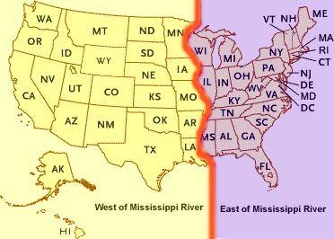
2 Physical Features ESSENTIAL QUESTION: How does geography influence the way people live? ~The United States can be divided into regions based on physical characteristics. Learning about each region will help you better understand our nation s geographic diversity. The Regions The most basic way to divide the United States is into two regions: the United States east of the Mississippi and the United States west of the Mississippi. The Mississippi River is the dividing line between the two regions. Geographers can further divide regions into smaller parts called subregions. Like a region, a subregion has special features that make it unique. The United States east of the Mississippi is made up of four subregions: New England, the Mid-Atlantic, the Midwest, and the Southeast.

3 New England New England is the subregion located in the northeastern corner of the United States, between Canada and the Atlantic Ocean. Many of the first English colonists who came to America during the 1600s settled in this area. The settlers named the area New England in hopes to create a new England in the New World.

4 The Mid-Atlantic The Middle Atlantic map includes the states of New Jersey, Pennsylvania, Delaware, and Maryland, as well as the southern New England states, southern New York, and eastern Virginia, West Virginia, North Carolina, and South Carolina. This historic region, where the first colonists settled, the Declaration of Independence was signed, and many of the Revolutionary War battles were fought, is the birthplace of America. The Mid-Atlantic region is comprised of the Appalachians and their foothills, as well as the Atlantic Coastal Plain. To the north and northwest, it is bordered by the easternmost Great Lakes.

5 The Midwest The states of Illinois, Indiana, Michigan, Ohio, and Wisconsin are part of the subregion called the Midwest. All five of these states share borders with one or more of the Great Lakes. The Midwest is nicknamed the nation s breadbasket because a large percentage of America s food crops are grown in its rich soil.

6 The Southeast The Southeast is the largest subregion in the eastern United States. The Southeast is made up of 11 states: Alabama, Florida, Georgia, Kentucky, Louisiana, Mississippi, North Carolina, South Carolina, Tennessee, Virginia, and West Virginia. Some Southeastern states have long coastal borders where they meet the Atlantic Ocean or the Gulf of Mexico.
, from Maine in the north to Florida in the south.")
7 The Atlantic Ocean The eastern United States is nearly surrounded by water. The largest body of water east of the Mississippi is the Atlantic Ocean. The East Coast is a shoreline that stretches for more than 2,000 miles (3,219 km), from Maine in the north to Florida in the south. The Atlantic Ocean affects the region s land, weather, economy, and people in many ways.

8 The Gulf of Mexico The Gulf Coast borders a smaller body of water called the Gulf of Mexico. The Gulf of Mexico covers an area of about 600,000 square miles and is nearly surrounded by land. Several currents flow through the Gulf of Mexico like giant underwater rivers. One of the currents feeds into the Gulf Stream, a powerful current that flows through the Atlantic Ocean. The Gulf Coast extends from Florida to Texas and Mexico. Waters in the Gulf of Mexico are warmer and generally calmer than those of the Atlantic.


9 The Great Lakes The term Great Lakes refers to a cluster of five huge lakes located in the American Midwest and central Canada. These lakes were formed thousands of years ago when massive glaciers carved out the ground and melted over time. The Great Lakes form the largest group of freshwater lakes in the world. Together, the Great Lakes hold more liquid freshwater than any other location on Earth. Moving from west to east, the Great Lakes are Lake Superior, Lake Michigan, Lake Huron, Lake Erie, and Lake Ontario. The five lakes are connected. Water flows west to east from one lake to the next, eventually making its way to the long St. Lawrence River.

10 The St. Lawrence Seaway The St. Lawrence River carries the water eastward for 750 miles, until it empties into the Atlantic Ocean. During the 1950s, the United States and Canada worked together to build canals and gated passageways called locks between the Great Lakes and into the St. Lawrence River. The locks and canals made it possible for ships to travel the entire length of the Great Lakes and the St. Lawrence River. The final passageway, extending 2,340 miles from Lake Superior to the Atlantic Ocean, is called the St. Lawrence Seaway. The St. Lawrence Seaway connects the Midwest to seaports all over the world. This has made it faster and easier for businesses in the Midwest to ship their products to buyers worldwide.

11 The Mississippi River The Mighty Mississippi is one of the longest rivers in North America; From its source in Minnesota, the Mississippi River winds its way southward for 2,350 miles to the Gulf of Mexico. Since early settlers arrived in America, the Mississippi River has affected the settlement patterns, the economy, and the lifestyles of countless Americans. In the past, the Mississippi would often flood its banks, dumping millions of tons of water and sediment onto the land; the sediment enriched the soil in farm fields, but the floods also destroyed homes and washed away entire fields of crops. The government built levees embankments to control the flooding and reduce the damage to homes and crops; Unfortunately, levees also block the sediment that used to replenish farm fields. The powerful Mississippi River has influenced the nation s history more than any other river. The river s importance, and the respect humans have for it, is shown in its name: Mississippi is a Choctaw word meaning Great Water or Father of Waters.

12 The Ohio River The Ohio River carries more water to the Mississippi River than any of the other tributaries. The Ohio River begins in western Pennsylvania. From Pennsylvania, the Ohio River flows westward for 981 miles, forming a wide, watery border that separates the states of Ohio, Indiana, and Illinois that lie along the north side of the river from West Virginia and Kentucky on its south side. Like the Mississippi, the Ohio River has long been an important shipping and transportation route. The Ohio River connects much of the Midwest to the Mississippi River.
13 Rivers as Boundaries Rivers make natural boundaries. The Mississippi River forms much of the western border of the states of Wisconsin, Illinois, Kentucky, Tennessee, and Mississippi. Rivers are boundaries for counties and cities, too. For example, the Tennessee River in northwest Alabama forms the border between Lauderdale County and Colbert County. Rivers are examples of physical systems that form political boundaries. Mountains and lakes are other physical features that may be used as political boundaries.
14 Physical Landscape Guiding Question: What characteristics make the physical landscape east of the Mississippi unique? The Atlantic Coastal Plain The East Coast of the United States sits at the edge of a huge continental platform. Most of this platform is underwater, forming a shelf around the Atlantic coastline. But over time, a large area of the platform rose above sea level and ocean waves washed over the platform for millions of years, leaving behind layers of sandy sediment. As the sediment built up, a flat lowland called the coastal plain formed. The coastal plain stretches from the northeastern U.S. to Mexico. In places, the coastal plain was crushed under the weight of glaciers, pushing the land below sea level and these areas often become flooded by fierce storms and heavy rains.

15 Atlantic Coastal Plains
 northeast to the Canadian border. Dense forests cover much of the Appalachian Mountains, which are known for their rugged beauty.")
16 The Appalachian Mountains The Appalachian Mountain system is the oldest, longest chain of mountains in the United States east of the Mississippi River. It begins in Alabama and continues 1,500 miles (2,414 km) northeast to the Canadian border. Dense forests cover much of the Appalachian Mountains, which are known for their rugged beauty. The mountains of the Appalachian system stand side by side in parallel ranges. Two of the most well-known Appalachian Mountain ranges are the Blue Ridge Mountains in Virginia and the Great Smoky Mountains in Tennessee.


17 Appalachians ctd. These mountain ranges were formed from sedimentary rock by powerful upheavals within Earth s crust. The mountains have worn down over time because of natural erosion. Compared to younger mountain ranges such as the Rockies in the western United States, the Appalachian Mountains show their age in their worn, rounded appearance. Old-growth forests are filled with diverse plant and animal life.


18 Appalachian Mtns. Some of the most spectacular features of the Appalachians are the thousands of waterfalls that decorate the landscape. The many waterfalls are evidence that a fall line runs through the region. A fall line is an area where waterfalls flow from higher to lower ground. In this region, a fall line stretches for hundreds of miles between New Jersey and South Carolina. The fall line forms a boundary between higher, upland areas and the Atlantic coastal plain. Many cities originally located along the fall line because waterfalls provide water power, a renewable resource.


19 Climate in the Eastern U.S. The climate of the eastern United States is as varied as the landscape. The changing seasons in most places east of the Mississippi are quite noticeable. New England and the Midwest see the most dramatic seasonal changes. These regions have cold winters and hot, humid summers. Autumn is cool and colorful as the leaves change color. Springtime brings rainy and snowy weather and strong storms.


20 Climate in Coastal Areas In general, climates of the eastern United States are more humid and rainy than climates of the West. Coastal areas tend to have mild climates: States along the East Coast still experience seasons, but temperatures are less extreme than they are inland. States located farther south experience milder changes in seasons. Much of the Southeast has a humid subtropical climate. Summers are rainy and hot, and winters are cooler and drier. In late summer and early autumn, hurricanes ocean storms that span hundreds of miles with winds of at least 74 miles per hour - can pound the coastline. One of the most damaging hurricanes in history, Hurricane Katrina, struck the Gulf Coast in August More than 1,800 people died, and hundreds of thousands lost their homes.


21 Minerals and Energy Sources A wealth of resources is hidden below the surface of the region, and two of the most valuable materials are minerals and energy resources. Minerals are natural substances such as iron ore, gold, and zinc. Energy resources, such as coal, oil, and natural gas, are called fossil fuels. Burning coal can produce electricity. Oil is processed into fuel for cars and other vehicles. Natural gas is used to heat our homes and to generate electricity. Mining resources is a major industry in the U.S. east of the Mississippi River. Minerals and energy resources are mined from inside mountains and from deep under the ground. Some mining methods harm the environment by damaging the land and polluting the water, soil, and air.


22 Farming and Industry One of the other most valuable resources east of the Mississippi River is farmland. The rich soil is excellent for growing crops such as grains, fruits, and vegetables. Sandy soils in the Southeast are good for growing cotton. Excellent growing conditions have helped the region become a major producer of meat, dairy foods, wood, cotton, sugar, corn, wheat, soybeans, and other food crops. Industries such as logging, mining, and fishing are a way of life throughout the region. Products such as automobiles, electronics, and clothing are made in factories in these cities.
EQ: Discuss main geographic landforms of the U.S. & Canada and examine varied landforms in relation to their lifestyles.
 EQ: Discuss main geographic landforms of the U.S. & Canada and examine varied landforms in relation to their lifestyles. Places & Terms for Discussion Appalachian Mountains Great Plains Canadian Shield
Guided Reading Activity
 Guided Reading Activity Lesson 1 Physical Features Essential Question: How does geography influence the way people live? A Vast Land Directions: Read the lesson and use your text to decide whether each
Unit 2. United States Physical Geography
 Unit 2 United States Physical Geography Physical Geography U.S. extends from the Atlantic to Pacific U.S. is the 3rd largest country U.S. has fertile soils, vast forests, and variety of minerals All major
2 Georgia: Its Heritage and Its Promise
 TERMS region, erosion, fault, elevation, Fall Line, aquifer, marsh, climate, weather, precipitation, drought, tornado, hurricane, wetland, estuary, barrier island, swamp PLACES Appalachian Mountains, Appalachian
Physical Geography of the United States and Canada Chapter 5 A Land of Contrasts
 Physical Geography of the United States and Canada Chapter 5 A Land of Contrasts Land Area Together the U.S. and Canada cover more than 7 million square miles. In total area, Canada ranks 2 nd and the
The United States & Canada. A Regional Study of Anglo America
 A Regional Study of Anglo America Landform Regions of the United States & Canada world leaders in agricultural and industrial production because of... VAST LANDS stretch from the Atlantic Ocean on the
Terms. divide headwaters tributary fall line fishery
 Chapter 5 Preview Section 1 The Land Objectives Identify some key similarities and differences in the physical geography of the United States and Canada. Explain why rivers have played such an important
4th Grade Social Studies First Nine Weeks
 4th Grade Social Studies First Nine Weeks Multiple Choice Identify the choice that best completes the statement or answers the question. 1 Name the mountains that are located in the eastern United States.
Unit 1: Geography. For additional information, refer to this website: 1 G e o g r a p h y
 Unit 1: Geography For additional information, refer to this website: http://mryoungtms.weebly.com/ 1 G e o g r a p h y Continents and Oceans SOL USI. 2a Essential Understanding: Continents are large land
discussion of North America s physical features, including its landforms and bodies of
 Chapter 7 Natural Environments of North America Chapter 7 focuses on the natural environments of North America. The chapter opens with a discussion of North America s physical features, including its landforms
Chapter 6, Part Colonizers arriving in North America found extremely landscapes. It looked different to region showing great.
 Social Studies 9 Unit 1 Worksheet Chapter 6, Part 1. 1. Colonizers arriving in North America found extremely landscapes. It looked different to region showing great. 2. The Earth is years old and is composed
4th Grade U.S. Regional Geography
 4th Grade U.S. Regional Geography Multiple Choice Identify the choice that best completes the statement or answers the question. What does the term mainland mean in the sentence above? A the continent
Grade 7 History Mr. Norton
 Grade 7 History Mr. Norton Section 1: Thinking Geographically Section 2: Land and Climates of the United States Section 3: The Tools of History Section 4: Economics and Other Social Sciences Grade 7 History
Explain the impact of location, climate, natural resources, and population distribution on Europe. a. Compare how the location, climate, and natural
 SS6G10 Explain the impact of location, climate, natural resources, and population distribution on Europe. a. Compare how the location, climate, and natural resources of Germany, the United Kingdom and
LATITUDE. Latitude lines run to, but are measured & The 0 of latitude that circles the earth is called the?
 LATITUDE Latitude lines run to, but are measured & The 0 of latitude that circles the earth is called the? LATITUDE 0 0 Latitude lines run east to west, but are measured north & south The 0 of latitude
Grade Five Social Studies Assessment Regions/Native Americans
 Name Grade Five Social Studies Assessment Regions/Native Americans Use the map below to answer questions 1 and 2 1. (Geo 1) For this location give the name of the city found there. 38 N, 100 W a. Scottsbluff
GUIDED READING CHAPTER 1: THE LAY OF THE LAND (Page 1)
") CHAPTER 1: THE LAY OF THE LAND (Page 1) Section 1 The Tidewater Region Directions: Use the information from pages 6-11 to complete the following statements. 1. In the southern part of the coast, the Tidewater
CHAPTER 1: THE LAY OF THE LAND (Page 1) Section 1 The Tidewater Region Directions: Use the information from pages 6-11 to complete the following statements. 1. In the southern part of the coast, the Tidewater
MARS AREA SCHOOL DISTRICT CURRICULUM GRADE: Grade 4
 MARS AREA SCHOOL DISTRICT CURRICULUM GRADE: Grade 4 Course Title: Social Studies Brief Description Overview: Students will explore the history, geography, government, and economy of the United States with
5th social studies geography (5thsocstud_geography)
") Name: Date: 1. Many of the Native Americans who lived on the Great Plains were nomadic people. Why did they move from place to place? A. They were finding new areas to mine. B. They were looking for fertile
Name: Date: 1. Many of the Native Americans who lived on the Great Plains were nomadic people. Why did they move from place to place? A. They were finding new areas to mine. B. They were looking for fertile
Introducing North America
 Introducing North America I. Quick Stats Includes U.S. & Canada U.S consists of 50 States Federal Government Democracy 4 th in world w/ land area 3 rd in population Economic leader of free world II. Major
Landforms and Bodies of Water
 Chapter 5, Section 1 For use with textbook pages 115 120. The Land Terms to Know divide A high point or ridge that determines the direction that rivers flow (page 118) headwaters The source waters of a
Unit 1: Geography CLASS WEBSITE: QUIZLET GAMES: ONLINE RESOURCES
 Unit 1: Geography ONLINE RESOURCES CLASS WEBSITE: HTTPS://MRYOUNGTMS.WEEBLY.COM/GEOGRAPHY.HTML QUIZLET GAMES: HTTPS://QUIZLET.COM/JOIN/MSFYY94T5 1 G e o g r a p h y Continents and Oceans The Seven Continents
CANADA S LANDFORM REGIONS
 CANADA S LANDFORM REGIONS Canada s Regions Canada is divided into Eight major regions. A Region is an area that is defined on the basis of the presence or absence of certain characteristics: Age of rock
Terms to Know. divide headwaters tributary fall line fishery
 Chapter Objectives Describe the dominant landforms and natural resources of the United States and Canada. Discuss climate and vegetation in the United States and Canada. Section 1 The Land Section Objectives
What is the largest country in the world? Russia
 What is the largest country in the world? #1 Russia CSCOPE 2007 2 Russia Dimensions #2-3 Spans 11 Time Zones From East to West: Gulf of Finland to Alaska From North to South: Above the Arctic Circle to
Warm Up Vocabulary Check
 Warm Up Vocabulary Check Surface current Coriolis Effect global winds upwelling Gulf Stream deep current climate El Nino convection current continental deflection 1.The apparent curving of the path of
Social Studies. Chapter 2 Canada s Physical Landscape
 Social Studies Chapter 2 Canada s Physical Landscape Introduction Canada s geography its landforms and climate - has a great impact on Canadians sense of identity. Planet Earth The earth is divided into
A. Geography Students know the location of places, geographic features, and patterns of the environment.
 Learning Targets Elementary Social Studies Grade 5 2014-2015 A. Geography Students know the location of places, geographic features, and patterns of the environment. A.5.1. A.5.2. A.5.3. A.5.4. Label North
Changes to Land 5.7B. landforms: features on the surface of Earth such as mountains, hills, dunes, oceans and rivers
 All the landforms on Earth have changed over time and continue to change. Many of the changes were caused by wind, moving water, and moving ice. Mountains have grown and shrunk. Rivers have cut away land
Climate. Annual Temperature (Last 30 Years) January Temperature. July Temperature. Average Precipitation (Last 30 Years)
 January Temperature. July Temperature. Average Precipitation (Last 30 Years)") Climate Annual Temperature (Last 30 Years) Average Annual High Temp. (F)70, (C)21 Average Annual Low Temp. (F)43, (C)6 January Temperature Average January High Temp. (F)48, (C)9 Average January Low Temp.
Climate Annual Temperature (Last 30 Years) Average Annual High Temp. (F)70, (C)21 Average Annual Low Temp. (F)43, (C)6 January Temperature Average January High Temp. (F)48, (C)9 Average January Low Temp.
Think about the landforms where you live. How do you think they have changed over time? How do you think they will change in the future?
 reflect All the landforms on Earth have changed over time and continue to change. Many of the changes were caused by wind, moving water, and moving ice. Mountains have grown and shrunk. Rivers have cut
Chapter 1 Study Guide
 Chapter 1 Study Guide Reminders: Vocabulary quiz and test will be on Tuesday, September 6th. Complete study guide and bring completed to school Friday, September 2nd. You are NOT required to print the
Post Test Trimester 1 US & Canada 6th Grade-Study Guide
 Post Test Trimester 1 US & Canada 6th Grade-Study Guide Matching Fill in the blank by writing the letter of the correct term below. a. dominion f. indigenous b. Industrial Revolution g. interdependent
Inter State Large Navigable Rivers of the United States
 Inter State Large Navigable Rivers of the United States REVIEW OF NORTH AMERICAN BASINS: GREAT LAKES AND MISSISSIPPI RIVER HELEN A. BROHL, EXECUTIVE DIRECTOR US COMMITTEE ON THE MARINE TRANSPORTATION SYSTEM
4 th Grade Virginia Studies SOL Review Packet Geography of Virginia. 1. The Algonquian language group of Indians lived in what region of Virginia?
 4 th Grade Virginia Studies SOL Review Packet Geography of Virginia 1. The Algonquian language group of Indians lived in what region of Virginia? A. Allegheny B. Piedmont C. Ridge and Valley D. Tidewater
Chapter 2: Physical Geography
 Chapter 2: Physical Geography Pg. 39-68 Learning Goals for Chp2: q q q q q Explain how the Earth moves in space and why seasons change. Outline the factors that influence climate and recognize different
North America ATLANTIC OCEAN PACIFIC OCEAN. The First Americans. Labrador Sea. Caribbean Sea. USI_ISN_U01_01.eps. Second Proof TCI19 65.
 G e o g r a p h y C h a l l e n g e North America 70 N 180 N 60 170 W 30 W 160 W 40 W Labrador Sea 150 W 50 N 50 W Hud s on B ay 140 W 40 N 60 W ATLANTIC OCEAN 30 N PACIFIC OCEAN Gulf of Mexico 20 N 130
CHAPTER 1. Geo Challenges 1A to 1D. & World Map Activity
 CHAPTER 1 Geo Challenges 1A to 1D & World Map Activity SELECT YOUR CHALLENGE World Map Activity Challenge 1A Challenge 1B Challenge 1C Challenge 1D Challenge 1A WS PG. 2 STEP #1 Label the largest continent
Factors Affecting Human Settlement
 Factors Affecting Human Settlement Physical Factors One of the most basic factors affecting settlement patterns is the physical geography of the land. Climate is key, because if a place is too dry, too
The Mississippi, Missouri, and Ohio Rivers
 The Mississippi, Missouri, and Ohio Rivers Mississippi River Mississippi River begins at Lake Itasca in northwest Minnesota and runs 2,320 miles to the Gulf of Mexico approx. 90 days for a drop of rain
Changes in Texas Ecoregions Copy the questions and answers
 Changes in Texas Ecoregions Copy the questions and answers 1. What are some kinds of damage that hurricanes cause? Roads and bridges might be washed away. Trees and power lines can be knocked down. Area
Terrain Units PALEOGEOGRAPHY: LANDFORM CREATION. Present Geology of NYS. Detailed Geologic Map of NYS
 NYS TOPOGRAPHY Why so? PALEOGEOGRAPHY: LANDFORM CREATION Prof. Anthony Grande AFG 014 Present Geology of NYS Detailed Geologic Map of NYS Generalized Geology Detailed Geology Hot links to the fold out
High School World History Cycle 2 Week 2 Lifework
 Name: Advisory: Period: High School World History Cycle 2 Week 2 Lifework This packet is due Monday, November 7 Complete and turn in on Friday for 10 points of EXTRA CREDIT! Lifework Assignment Complete
Weathering and Erosion
 Have you ever looked at the land around you and wondered how it was shaped? The geologic features that help define the world are still being shaped by the natural processes of weathering, erosion, and
Ocean s Influence on Weather and Climate
 Earth is often called the Blue Planet because so much of its surface (about 71%) is covered by water. Of all the water on Earth, about 96.5%, is held in the world s oceans. As you can imagine, these oceans
Earth Science S5E1b (EarthScienceS5E1b)
") Name: Date: 1. The flattest part of the ocean floor is the A. trench. B. abyssal plain. C. continental shelf. D. mid-ocean rift valley. 2. Which causes some parts of the ocean to be saltier than other
Name: Date: 1. The flattest part of the ocean floor is the A. trench. B. abyssal plain. C. continental shelf. D. mid-ocean rift valley. 2. Which causes some parts of the ocean to be saltier than other
Monday September 11, 2017
 Monday September 11, 2017 Need: 9/11 Interview Paper Agenda: Good things Warm Up: Video and Reflection Circles Sharing Interview Stories Discussion Questions Whole group sharing Summarizer: Living in a
World Geography Chapter 3
 World Geography Chapter 3 Section 1 A. Introduction a. Weather b. Climate c. Both weather and climate are influenced by i. direct sunlight. ii. iii. iv. the features of the earth s surface. B. The Greenhouse
Chapter 1: America s Land Lesson 1: Land and Climate
 Chapter 1: America s Land Lesson 1: Land and Climate Geography: Describe landforms and other physical features of the United States. Geography: Explain how and why climate varies throughout the United
The Pennsylvania Observer
 The Pennsylvania Observer April 2, 2010 March 2010 Pennsylvania Weather Recap Prepared by: Katelyn Johnson March did come in as a lion cub this year. The 1 st proved to be a calm day; however most of Pennsylvania
Module 10: Resources and Virginia Geology Topic 4 Content: Virginia Geology Notes
 Virginia is composed of a very diverse landscape that extends from the beaches and barrier islands all of the way to the highly elevated Appalachian Plateau. Geologists have discovered ancient shallow
Crop / Weather Update
 Crop / Weather Update Corn Crop Condition Percent of Acreage Rated Good or Excellent 85 80 75 70 65 60 55 50 45 Corn condition this week is the same as the last two weeks in the good/excellent category,
The map shows ocean currents in the northern Atlantic Ocean. Which location most likely has the warmest climate?
 6 th Grade Final Exam Study Guide 1. Use the map below to answer this question. The map shows ocean currents in the northern Atlantic Ocean. Which location most likely has the warmest climate? 2. Daylight
Developed in Consultation with Florida Educators
 Developed in Consultation with Florida Educators Table of Contents Next Generation Sunshine State Standards Correlation Chart... 7 Benchmarks Chapter 1 The Practice of Science...................... 11
ELEMENTS OF BASIC WORLD GEOGRAPHY TABLE OF CONTENTS UNIT 1 THE BASICS OF GEOGRAPHY AND NORTH AMERICA
 TABLE OF CONTENTS UNIT 1 THE BASICS OF GEOGRAPHY AND NORTH AMERICA IMPORTANT WORDS TO KNOW... 1 CHAPTER 1 THE BASICS OF GEOGRAPHY GEOGRAPHY... 2 TOOLS OF GEOGRAPHY... 3 EARTH...4 SEASONS, CLIMATE, AND
National Wildland Significant Fire Potential Outlook
 National Wildland Significant Fire Potential Outlook National Interagency Fire Center Predictive Services Issued: April 1, 2008 Next Issue: May 1, 2008 Wildland Fire Outlook April 2008 through July 2008
Crop / Weather Update
 Crop / Weather Update Corn Crop Condition Percent of Acreage Rated Good or Excellent 85 80 75 70 65 60 55 50 45 As of September 9, USDA rates the crop at 68% good to excellent. The rating is up one point
How Geographers View the World: Human Geography. ESSENTIAL QUESTION: How does geography influence the way people live?
 How Geographers View the World: Human Geography ESSENTIAL QUESTION: How does geography influence the way people live? Geographers Think Spatially Gefffffdgfhfjgjp Guiding Question: What does it mean to
Crop / Weather Update
 Crop / Weather Update Corn Crop Condition Percent of Acreage Rated Good or Excellent 85 80 75 70 65 60 55 50 45 The U.S. corn crop was rated 69% good-to-excellent on September 23, up 1% from week-ago,
GLOBAL CLIMATES FOCUS
 which you will learn more about in Chapter 6. Refer to the climate map and chart on pages 28-29 as you read the rest of this chapter. FOCUS GLOBAL CLIMATES What are the major influences on climate? Where
(version 3) I. HumAN -Environment Interaction
 I. HumAN -Environment Interaction") (version 3) I. HumAN -Environment Interaction A. Landforms 1. Earth s topography is made up of many different types of landforms. 2. While the planet is covered primarily with water, the four major types
(version 3) I. HumAN -Environment Interaction A. Landforms 1. Earth s topography is made up of many different types of landforms. 2. While the planet is covered primarily with water, the four major types
1 Earth s Oceans. TAKE A LOOK 2. Identify What are the five main oceans?
 CHAPTER 13 1 Earth s Oceans SECTION Exploring the Oceans BEFORE YOU READ After you read this section, you should be able to answer these questions: What affects the salinity of ocean water? What affects
Earth s Resources. Earth s Surface
 Earth s Resources Earth s Surface Earth s surface is made up of a layer of rock called the crust. The crust covers all of Earth. It is several miles thick. Most of the crust is under water. The upper part
Erosion and Deposition
 CHAPTER 3 LESSON 2 Erosion and Deposition Landforms Shaped by Water and Wind Key Concepts What are the stages of stream development? How do water erosion and deposition change Earth s surface? How do wind
Name: Period: Date: ID: A. Circle the choice that best completes the statement or answers the question and write the letter on the blank.
 Name: Period: _ Date: _ ID: A Unit 7 Practice Circle the choice that best completes the statement or answers the question and write the letter on the blank. 1. What term describes the movement of rock
Thermal / Solar. When air is warmed it... Rises. Solar Energy. Evaporation. Condensation Forms Clouds
 Thermal / Solar Light from the Sun is transformed into what type of energy when it hits Earth's surface? Rises When air is warmed it... Solar Energy Water moves through the water cycle using what type
middle-atlantic States 1-3. Storm King of the Hudson
 middle-atlantic States 1-3. Storm King of the Hudson Imagine a place without cars, housing additions, or even a McDonald s, where nature s beauty surrounds you and few people have traveled. What would
Landforms in Canada. Canada is made up of three dis;nct types of landforms: Canadian Shield Highlands Lowlands
 Canada s Landforms What is a Landform? A landform is any physical feature of the Earth s surface having a characteris;c, recognizable shape, produced by natural causes. Landforms include major features
National Wildland Significant Fire Potential Outlook
 National Wildland Significant Fire Potential Outlook National Interagency Fire Center Predictive Services Issued: September, 2007 Wildland Fire Outlook September through December 2007 Significant fire
Wednesday, November 15, 2017
 Wednesday, November 15, 2017 Northern Europe: Physical Geography Objective: Locate and describe the various traditional regions of Western Europe. Outline how the physical geography varies from region
The Great Lakes. Beyond the Book. FOCUS Book
 Build a model to show how the Great s formed. Use soil and large pieces of ice to model the role of ice sheets as they carved out the Great s Basin and then filled it with water. How will you make the
Changes in Texas Ecoregions
 Comment On Lesson Changes in Texas Ecoregions The state of Texas can be divided into 10 distinct areas based on unique combinations of vegetation, topography, landforms, wildlife, soil, rock, climate,
Earth processes are dynamic actions that occur both on
 29 Weathering, Erosion, and Deposition R EA D I N G Earth processes are dynamic actions that occur both on the earth s surface and inside the earth. Any process that breaks down earth material, such as
Chapter 1. Social Studies History and Geography
 Chapter 1 Social Studies History and Geography Unit 01 Geography Skills 1 Reading Maps Key Words border landform rely on display focus on route locater 1 There are many different kinds of maps. A political
Chapter 2 Planet Earth
 Chapter 2 Planet Earth Section Notes Earth and the Sun s Energy Water on Earth The Land Close-up The Water Cycle World Almanac Major Eruptions in the Ring of Fire Quick Facts Chapter 2 Visual Summary Video
All of Virginia's 4 main rivers flow into the... Chesapeake Bay. Along which river would Jamestown be found? James River. Appalachian Mountains
 All of Virginia's 4 main rivers flow into the... Along which river would Jamestown be found? The Blue Ridge Mountains and Valley and Ridge are part of what large mountain system? Define climate. Define
Natural Texas. Regions and Climates
 Natural Texas Regions and Climates Two Kinds: Physical geography Climate, vegetation, rivers, lakes, oceans, plateaus, plains, and mountain ranges Human geography Economic activities How we earn a living
PALEOGEOGRAPHY of NYS. Definitions GEOLOGIC PROCESSES. Faulting. Folding 9/6/2012. TOPOGRAPHIC RELIEF MAP of NYS GRADATIONAL TECTONIC
 TOPOGRAPHIC RELIEF MAP of NYS PALEOGEOGRAPHY of NYS Prof. Anthony Grande AFG 2012 Definitions GEOLOGIC PROCESSES Geography: study of people living on the surface of the earth. Geology: the scientific study
LANDFORM REGIONS IN CANADA. Classroom Notes and Descriptions
 LANDFORM REGIONS IN CANADA Classroom Notes and Descriptions Landform Regions in Canada There are eight distinct landforms in Canada: Western Cordillera Region Interior Plains Canadian Shield Hudson Bay
CLIMATE. UNIT TWO March 2019
 CLIMATE UNIT TWO March 2019 OUTCOME 9.2.1Demonstrate an understanding of the basic features of Canada s landscape and climate. identify and locate major climatic regions of Canada explain the characteristics
Name Date Class. well as the inland, found near the Tropics. 4. In the, or the regions near the Equator, you may find a lush
 WATER, CLIMATE, AND VEGETATION Vocabulary Activity DIRECTIONS: Fill in the Blanks Select a term from below to complete each of the following sentences. CHAPTER 1. The constant movement of water, a process
L.O Students will learn about factors that influences the environment
 Name L.O Students will learn about factors that influences the environment Date 1. At the present time, glaciers occur mostly in areas of A) high latitude or high altitude B) low latitude or low altitude
1. Which weather map symbol is associated with extremely low air pressure? A) B) C) D) 2. The diagram below represents a weather instrument.
 B) C) D) 2. The diagram below represents a weather instrument.") 1. Which weather map symbol is associated with extremely low air pressure? 2. The diagram below represents a weather instrument. Which weather variable was this instrument designed to measure? A) air pressure
1. Which weather map symbol is associated with extremely low air pressure? 2. The diagram below represents a weather instrument. Which weather variable was this instrument designed to measure? A) air pressure
Geography Terms. Work with your desk partner, using your technology, to define and illustrate each term.
 Geography Terms Work with your desk partner, using your technology, to define and illustrate each term. 1. Continent 2. Hemisphere 3. Nation 4. Absolute location 5. Relative location 6. Latitude 7. Longitude
Erik Kabela and Greg Carbone, Department of Geography, University of South Carolina
 Downscaling climate change information for water resources Erik Kabela and Greg Carbone, Department of Geography, University of South Carolina As decision makers evaluate future water resources, they often
How does erosion happen?
 How does erosion happen? By National Geographic, adapted by Newsela staff on 10.03.17 Word Count 682 Level 830L These rock formations, in Bryce Canyon National Park, Utah, are called hoodoos. Although
Weather and Climate Risks and Effects on Agriculture
 Weather and Climate Risks and Effects on Agriculture Dr. Eric Snodgrass Official Journal of the Fluid Fertilizer Foundation Vol. 26, No. 2, Issue #100 DOWNLOAD Summary: So, what do we need to watch for?
GEOGRAPHY OF THE UNITED STATES & CANADA. By Brett Lucas
 GEOGRAPHY OF THE UNITED STATES & CANADA By Brett Lucas THE APPALACHIANS & THE OZARKS Setting the Boundaries What states and provinces are part of the region? Eastern TN, western NC, eastern KY, western
What a Hurricane Needs to Develop
 Weather Weather is the current atmospheric conditions, such as air temperature, wind speed, wind direction, cloud cover, precipitation, relative humidity, air pressure, etc. 8.10B: global patterns of atmospheric
Chapter 1 Section 2. Land, Water, and Climate
 Chapter 1 Section 2 Land, Water, and Climate Vocabulary 1. Landforms- natural features of the Earth s land surface 2. Elevation- height above sea level 3. Relief- changes in height 4. Core- most inner
3) What is the difference between latitude and longitude and what is their affect on local and world weather and climate?
 What is the difference between latitude and longitude and what is their affect on local and world weather and climate?") www.discoveryeducation.com 1) Describe the difference between climate and weather citing an example of each. Describe how water (ocean, lake, river) has a local effect on weather and climate and provide
www.discoveryeducation.com 1) Describe the difference between climate and weather citing an example of each. Describe how water (ocean, lake, river) has a local effect on weather and climate and provide
Summary of Natural Hazard Statistics for 2008 in the United States
 Summary of Natural Hazard Statistics for 2008 in the United States This National Weather Service (NWS) report summarizes fatalities, injuries and damages caused by severe weather in 2008. The NWS Office
Monthly Long Range Weather Commentary Issued: SEPTEMBER 19, 2016 Steven A. Root, CCM, Chief Analytics Officer, Sr. VP,
 Monthly Long Range Weather Commentary Issued: SEPTEMBER 19, 2016 Steven A. Root, CCM, Chief Analytics Officer, Sr. VP, sroot@weatherbank.com SEPTEMBER 2016 Climate Highlights The Month in Review The contiguous
Monthly Long Range Weather Commentary Issued: APRIL 18, 2017 Steven A. Root, CCM, Chief Analytics Officer, Sr. VP,
 Monthly Long Range Weather Commentary Issued: APRIL 18, 2017 Steven A. Root, CCM, Chief Analytics Officer, Sr. VP, sroot@weatherbank.com MARCH 2017 Climate Highlights The Month in Review The average contiguous
Canada s Natural Systems. Canadian Geography 1202 September/October 2014
 Canada s Natural Systems Canadian Geography 1202 September/October 2014 Canada s Natural Systems Natural System: A system found in nature Here are the four natural systems that we will explore in the next
Hello everybody! 1) Please read through each question carefully.
 Please read through each question carefully.") Hello everybody! Using the textbook that has been shared with you in Google please keep track of what you are learning here in this document. This is preparation for your tasks in The Amazing Race Canada,
Hello everybody! Using the textbook that has been shared with you in Google please keep track of what you are learning here in this document. This is preparation for your tasks in The Amazing Race Canada,
Weather and Climate Summary and Forecast March 2019 Report
 Weather and Climate Summary and Forecast March 2019 Report Gregory V. Jones Linfield College March 2, 2019 Summary: Dramatic flip from a mild winter to a top five coldest February on record in many locations
Foundations of Earth Science, 6e Lutgens, Tarbuck, & Tasa
 Foundations of Earth Science, 6e Lutgens, Tarbuck, & Tasa Weather Patterns and Severe Weather Foundations, 6e - Chapter 14 Stan Hatfield Southwestern Illinois College Air masses Characteristics Large body
Weather Vs. Climate. Weather Vs. Climate. Chapter 14
 Weather Vs. Climate Chapter 14 Weather: Conditions of the atmosphere at a particular time and place, for short periods of time (days). Climate: Long-term averages of weather (Averaged over 30 yrs). Weather
Physical Geography. Ariel view of the Amazon Rainforest. A Look at the Seven Continents
 Physical Geography In this unit you will learn about general physical geography. The study of the Earth s surface features provides the setting for the human-environmental interactions and for the human