A Stochastic Simulation of Natural Organic Matter and Microbes in the Environment
|
|
|
- Shonda Norman
- 5 years ago
- Views:
Transcription
1 A Stochastic Simulation of Natural Organic Matter and Microbes in the Environment Xiaorong Xiang Gregory Madey Yingping Huang Steve Cabaniss (University of New Mexico) Department of Computer Science and Engineering University of Notre Dame Sponsored by NSF/ITR-DEB
2 Objectives New approach for NOM modeling Agent-based modeling E-Science on the Web Intelligent interface The NOM Collaboratory
3 Outline Introduction Modeling Core simulation engine Intelligent Web-based interface The NOM collaboratory Conclusion Future work
4 Introduction What is Natural Organic Matter (NOM)? Role of NOM in various science disciplines Mobility and transport of pollutants Availability of nutrients for microorganisms and plant communities Affects quality of drinking water Need to understand the evolution and heterogeneous structure of NOM

![Bog [DOC]](/docs-images/89/97695833/images/5-3.jpg "7 MW 2200")

![[DOC] 17](/docs-images/89/97695833/images/5-5.jpg "MW 1500")

5 Forest Service Bog [DOC] 7 MW 2200 Twomile Creek [DOC] 17 MW 1500 Nelson Creek [DOC] 79 MW 900
6 Previous models Two examples: Daisy (S. Hansen, H. E. Jensen, and N. E. Nielsen 1990-present) : a soil plant atmosphere system model StochSim (C. J. Morton-Firth 1998-present): Stochastic simulation of cell signaling pathways

 (nanoseconds) small low (Atoms number")
7 large (Large ecosystem) (Years) Elemental Cycling Scale (size, temporal) Copyright 1998, Thomas M. Terry,TheUniversity of Conn Daisy StochSim NOM 1.x Connectivity Maps (One molecule) (nanoseconds) small low (Atoms number Percentage) Detail (structure) high (Forces between atoms Electron density)
8 Our model Agent-based modeling (Individual-based modeling) Agent-based model Reynolds (1987): Flocks, herds, and schools: A distributed behavioral model. Computer Graphics Each molecule as an individual object with spatial properties Bottom-up approach Stochastic model Trace changes of the system Database and data mining technologies
9 Our model (cont.) Web-based simulation model Serve as an example for E-Science G. Fox (2002): E-science meets computational science and information technology. Computing & Engineering R. M. Jakobovits, J. F. Brinkley, C. Rosse, and E.Weinberger (1998): Enabling clinicians, researchers, and eductors to build custom Web-based biomedical information system Support the collaborations, data and information sharing between scientists No installation, expensive computation resources needed by scientists
10 Outline Introduction Modeling Core simulation engine Intelligent Web-based interface The NOM collaboratory Conclusion Future work
11 Modeling A complex system Consists of a large number of objects Molecules, Microbes Heterogeneous properties Individual behaviors Interaction between each other Objects behavior and interaction are stochastically determined by: Attributes (intrinsic parameters) Reactions rates Environment condition (extrinsic parameters) No central control Emergent properties
12 Modeling (cont.) Agent Attributes More specific than percent carbon but less detailed than a molecular connectivity map Elemental composition (C, H, O, N, S, P) Functional groups (double bonds, ring structure, alcohols ) The origin of objects spatial position in the system Precursor type of molecule Probability table of physical and chemical reactions Molecule weight
13 Modeling (cont.) Agent Behaviors (reactions and processes): Transport through soil pores by water (spatial mobility) Adsorb onto or desorbed from mineral surfaces Chemical reactions Total 10 types in current model First order Second order Stochastically determined Space: 2-D grid
14 Modeling(cont.) Environmental parameters Temperature ph Light intensity Microbe density Water flow rate
15 Outline Introduction Modeling Core simulation engine Intelligent Web-based interface The NOM collaboratory Conclusion Future work
16 Core simulation engine Implementation Swarm toolkit (Santa Fe Institute) Java programming language (Sun JDK 1.4.1_01) GUI version View the animation of molecules Easy for debugging and modeling Web-based version
17 Core simulation engine (cont.) Read simulation parameter from the database (JDBC) Environmental parameters (ph, temperature, light intensity, and so on) Molecule types and distributions User defined time has been separated to a large number of equal size time steps Write relevant data into the database every time step (JDBC) Trace the dynamic properties of individuals and the system over time

18 Visualization Black - No Adsorption Grays - Levels of Adsorption Red - Lignins Green - Cellulose Blue - Proteins Yellow - Reacted Orange - Adsorbed

19 Visualizations NOM molecules in solution and adsorption

20 Outline Introduction Modeling Core simulation engine Intelligent Web-based interface The NOM collaboratory Conclusion Future work
21 Web-based model Distributed, Web-based scientific application model Based on Sun Java 2 Enterprise Edition (J2EE) Standard HTML Forms / JSP Java Servlets, Java Beans JDBC - Oracle Oracle Database, Oracle Forms, and Reports Three parts: Intelligent Web-based interface Core simulation engine Data analysis packages, Data mining technologies

22 Access NOM simulation from Web

23 Web-based interface Submitted simulations Start a new one Sign up Simulation reports Terminate Parameter input New user Login Dynamic running time prediction notification Find similar simulations Restarter Static running time prediction Invoke simulation Database Simulation engines


24 Example of Interface

25 Report example
26 Intelligent interface components notification Running time prediction Static number of molecules number of time steps Dynamic current time step current wall clock time
27 Intelligent interface components (cont.) Find similar simulations Environment parameters Molecule types and distributions Retrieve the data sets from database Points on a high dimension space Euclidean distance Ordered list Review the simulation results or restart
28 Intelligent interface components (cont.) Automatic restarter Save the state of each objects in the system to database every check point Load the state to the core simulation engine
29 Outline Introduction Modeling Core simulation engine Intelligent Web-based interface The NOM collaboratory Conclusion Future work
30 Previous work Combination of words collaboration and laboratory first coined by William Wulf (1996): Richard T. Kouzes, James D. Myers, and William A. Wulf. Collaboratories: Doing science on the internet. IEEE Computer, 1996 Diesel Collaboratory: C. M. Pancerella, L. A. Rahn, and C. L. Yang: The diesel combustion collaboratory: combustion researchers collaborating over the internet. In Proceedings of the 1999 ACM/IEEE conference on Supercomputing BioCoRE: EMSL Collaboratory:
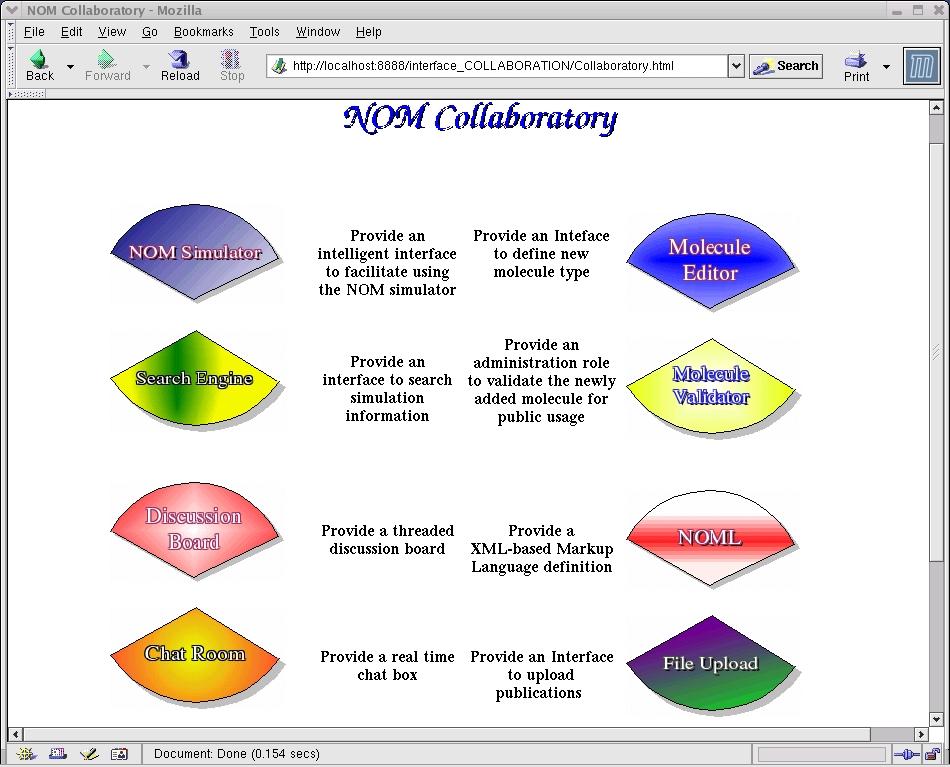
31 The NOM Collaboratory Interdisciplinary project Chemists Biologists Ecologists Computer Scientists Build and integrate software using J2EE NOM modeling & simulation software XML-based standard data format definitions Data querying and manipulation tools Electronic communication tools

32
33 XML-based NOM Markup Language (NOML) NOML: Standard data format Environment.dtd, Molecules.dtd, Setup.dtd Facilitate communication User ==== User Application ==== Application Extension
34 Other tools Molecule editor Define new molecule type Molecule validator Authorized persons (Chemists) to validate data Share the molecule type Search engine Ad-hoc query View results of the completed simulations Restart some simulations
35 Outline Introduction Modeling Core simulation engine Intelligent Web-based interface The NOM collaboratory Conclusion Future work
36 Conclusion Agent-based stochastic model for simulating the NOM evolution with discrete temporal and spatial properties A Web-based simulation architecture (multiple simulation servers, database servers, and data mining technologies) Database technologies A Web-based intelligent configuration interface The NOM collaboratory
37 Outline Introduction Modeling Core simulation engine Intelligent Web-based interface The NOM collaboratory Conclusion Future work
38 Future work Model testing (this summer) Testing of the sorption process More features need to be added into the core simulation engine Model validation (this summer) Collaboratory: More communication tools More simulation models for NOM study NOML extension
39 Thank You! Questions?
40

41 GUI version

42 Init Add molecule Randomly pick one Sorption Work flow yes Without split With split disappear Find nearest empty cell Get reaction probabilities Random number First order no Find nearest one yes move Leave no All checked yes no no no Update the probability table & Molecule structure All checked yes Completed Randomly pick one yes Terminate
Web-based Molecular Modeling Using Java/Swarm, J2EE and RDBMS Technologies
 Web-based Molecular Modeling Using Java/Swarm, J2EE and RDBMS Technologies Yingping Huang, Gregory Madey Xiaorong Xiang, Eric Chanowich University of Notre Dame Partially supported by NFS-ITR Research
Modeling the Evolution of Natural Organic Matter in the Environment with an Agent-Based Stochastic Approach
 University of Nebraska - Lincoln DigitalCommons@University of Nebraska - Lincoln Papers in the Earth and Atmospheric Sciences Earth and Atmospheric Sciences, Department of Spring 2006 Modeling the Evolution
Verification and Validation of an Agent-based Simulation Model
 Verification and Validation of an Agent-based Simulation Model Nadine Shillingford Gregory Madey Ryan C. Kennedy Department of Computer Science and Engineering University of Notre Dame Notre Dame, IN 46556
Web Visualization of Geo-Spatial Data using SVG and VRML/X3D
 Web Visualization of Geo-Spatial Data using SVG and VRML/X3D Jianghui Ying Falls Church, VA 22043, USA jying@vt.edu Denis Gračanin Blacksburg, VA 24061, USA gracanin@vt.edu Chang-Tien Lu Falls Church,
A Model of GIS Interoperability Based on JavaRMI
 A Model of GIS Interoperability Based on Java Gao Gang-yi 1 Chen Hai-bo 2 1 Zhejiang University of Finance & Economics, Hangzhou 310018, China 2 College of Computer Science and Technology, Zhejiang UniversityHangzhou
Environmental Chemistry through Intelligent Atmospheric Data Analysis (EnChIlADA): A Platform for Mining ATOFMS and Other Atmospheric Data
: A Platform for Mining ATOFMS and Other Atmospheric Data") Environmental Chemistry through Intelligent Atmospheric Data Analysis (EnChIlADA): A Platform for Mining ATOFMS and Other Atmospheric Data Katie Barton, John Choiniere, Melanie Yuen, and Deborah Gross
Environmental Chemistry through Intelligent Atmospheric Data Analysis (EnChIlADA): A Platform for Mining ATOFMS and Other Atmospheric Data Katie Barton, John Choiniere, Melanie Yuen, and Deborah Gross
Spatial analysis in XML/GML/SVG based WebGIS
 Spatial analysis in XML/GML/SVG based WebGIS Haosheng Huang, Yan Li huang@cartography.tuwien.ac.at and yanli@scnu.edu.cn Research Group Cartography, Vienna University of Technology Spatial Information
A Prototype of a Web Mapping System Architecture for the Arctic Region
 A Prototype of a Web Mapping System Architecture for the Arctic Region Han-Fang Tsai 1, Chih-Yuan Huang 2, and Steve Liang 3 GeoSensorWeb Laboratory, Department of Geomatics Engineering, University of
Watershed Application of WEPP and Geospatial Interfaces. Dennis C. Flanagan
 Watershed Application of WEPP and Geospatial Interfaces Dennis C. Flanagan Research Agricultural Engineer USDA-Agricultural Research Service Adjunct Professor Purdue Univ., Dept. of Agric. & Biol. Eng.
Innovation. The Push and Pull at ESRI. September Kevin Daugherty Cadastral/Land Records Industry Solutions Manager
 Innovation The Push and Pull at ESRI September 2004 Kevin Daugherty Cadastral/Land Records Industry Solutions Manager The Push and The Pull The Push is the information technology that drives research and
Web-based Interactive Landform Simulation Model (WILSIM)
") Web-based Interactive Landform Simulation Model (WILSIM) Wei Luo Dept. of Geography Northern Illinois University, DeKalb, IL 60115 Project Funded by NSF CCLI (2002-2004) Collaborators: Kirk Duffin, Jay
Web-based Interactive Landform Simulation Model (WILSIM) Wei Luo Dept. of Geography Northern Illinois University, DeKalb, IL 60115 Project Funded by NSF CCLI (2002-2004) Collaborators: Kirk Duffin, Jay
Web-GIS based Framework for Solid Waste Complaint Management for Sustainable and Smart City
 Cloud Publications International Journal of Advanced Remote Sensing and GIS 2016, Volume 5, Issue 10, pp. 1930-1936 ISSN 2320-0243, DOI: 10.23953/cloud.ijarsg.71 Research Article Open Access Web-GIS based
Stochastic Simulation Methods for Solving Systems with Multi-State Species
 Stochastic Simulation Methods for Solving Systems with Multi-State Species Zhen Liu Thesis submitted to the Faculty of the Virginia Polytechnic Institute and State University in partial fulfillment of
Calculating the Spread of Wildfires
 Calculating the Spread of Wildfires New Mexico Supercomputing Challenge Final Report April 5, 2017 Team 85 Los Alamos Middle School Seventh Grade Physics Programmed in Python Team Members: Jonathan Triplett:
CHAPTER 22 GEOGRAPHIC INFORMATION SYSTEMS
 CHAPTER 22 GEOGRAPHIC INFORMATION SYSTEMS PURPOSE: This chapter establishes the administration and use of to improve the quality and accessibility of Department s spatial information and support graphical
WEB-BASED SPATIAL DECISION SUPPORT: TECHNICAL FOUNDATIONS AND APPLICATIONS
 WEB-BASED SPATIAL DECISION SUPPORT: TECHNICAL FOUNDATIONS AND APPLICATIONS Claus Rinner University of Muenster, Germany Piotr Jankowski San Diego State University, USA Keywords: geographic information
Personal Field Data Collection by UM-FieldGIS (Integration of Google Map API to Mobile GIS)
") Personal Field Data Collection by UM-FieldGIS (Integration of Google Map API to Mobile GIS) Ko Ko Lwin*. Yuji MURAYAMA* *Division of Spatial Information Science Graduate School of Life and Environmental
Personal Field Data Collection by UM-FieldGIS (Integration of Google Map API to Mobile GIS) Ko Ko Lwin*. Yuji MURAYAMA* *Division of Spatial Information Science Graduate School of Life and Environmental
Last updated: Copyright
 Last updated: 2012-08-20 Copyright 2004-2012 plabel (v2.4) User s Manual by Bioinformatics Group, Institute of Computing Technology, Chinese Academy of Sciences Tel: 86-10-62601016 Email: zhangkun01@ict.ac.cn,
CS 350 A Computing Perspective on GIS
 CS 350 A Computing Perspective on GIS What is GIS? Definitions A powerful set of tools for collecting, storing, retrieving at will, transforming and displaying spatial data from the real world (Burrough,
Bentley Map Advancing GIS for the World s Infrastructure
 Bentley Map Advancing GIS for the World s Infrastructure Presentation Overview Why would you need Bentley Map? What is Bentley Map? Where is Bentley Map Used? Why would you need Bentley Map? Because your
Geometric Algorithms in GIS
 Geometric Algorithms in GIS GIS Visualization Software Dr. M. Gavrilova GIS Software for Visualization ArcView GEO/SQL Digital Atmosphere AutoDesk Visual_Data GeoMedia GeoExpress CAVE? Visualization in
Oracle Spatial: Essentials
 Oracle University Contact Us: 1.800.529.0165 Oracle Spatial: Essentials Duration: 5 Days What you will learn The course extensively covers the concepts and usage of the native data types, functions and
Bentley Geospatial update
 Bentley Geospatial update Tallinna, 01.11.2007 Timo Tuukkanen, Bentley Systems Issues today Bentley Map available now detailed introduction to Bentley Map Bentley Geo Web Publisher Bentley Web GIS update,
ANNA UNIVERSITY, CHENNAI AFFILIATED INSTITUTIONS R-2013 B.E. COMPUTER SCIENCE AND ENGINEERING I TO VIII SEMESTER CURRICULUM AND SYLLABUS SEMESTER I
 ANNA UNIVERSITY, CHENNAI AFFILIATED INSTITUTIONS R-2013 B.E. COMPUTER SCIENCE AND ENGINEERING I TO VIII SEMESTER CURRICULUM AND SYLLABUS SEMESTER I 1. HS6151 Technical English I 3 1 0 4 2. MA6151 Mathematics
How does ArcGIS Server integrate into an Enterprise Environment? Willy Lynch Mining Industry Specialist ESRI, Denver, Colorado USA
 How does ArcGIS Server integrate into an Enterprise Environment? Willy Lynch Mining Industry Specialist ESRI, Denver, Colorado USA wlynch@esri.com ArcGIS Server Technology Transfer 1 Agenda Who is ESRI?
Design and implementation of a new meteorology geographic information system
 Design and implementation of a new meteorology geographic information system WeiJiang Zheng, Bing. Luo, Zhengguang. Hu, Zhongliang. Lv National Meteorological Center, China Meteorological Administration,
How to Pick a GIS. GIS Software Chapter 8 in Longley, Goodchild, Maguire, and Rhind,, 2001
 How to Pick a GIS GIS Software Chapter 8 in Longley, Goodchild, Maguire, and Rhind,, 2001 How to Pick a GIS Evolution of GIS software Architecture of GIS software Types of software Example products The
Introduction to ArcGIS Server - Creating and Using GIS Services. Mark Ho Instructor Washington, DC
 Introduction to ArcGIS Server - Creating and Using GIS Services Mark Ho Instructor Washington, DC Technical Workshop Road Map Product overview Building server applications GIS services Developer Help resources
The Canadian Ceoscience Knowledge Network. - A Collaborative Effort for Unified Access to Ceoscience Data
 The Canadian Ceoscience Knowledge Network - A Collaborative Effort for Unified Access to Ceoscience Data The Canadian Geoscience Knowledge Network A Collaborative Effort for Unified Access to Geoscience
FREIS: A WEB-BASED RESOURCES AND ENVIRONMENT INFORMATION SYSTEM FOR AGRO-ECOSYSTEM MANAGEMENT
 FREIS: A WEB-BASED RESOURCES AND ENVIRONMENT INFORMATION SYSTEM FOR AGRO-ECOSYSTEM MANAGEMENT Mingxin Men *, Yuepu Qi, Boyang Du, Hao Xu College of Agricultural Resources and Environmental Sciences, Hebei
GERSVIEW: A New Database for Web Mapping
 GERSVIEW: A New Database for Web Mapping William J. Hernández, M.S. Graduate Student Department of Marine Sciences-UPRM Fernando Gilbes, Ph.D. Associate Professor Department of Geology-UPRM Overview Introduction
Experiences and Directions in National Portals"
 FIG Seminar on e-land Administration Innsbruck/Austria 2-4 June 2004 "ESRI's Experiences and Directions in National Portals" Kevin Daugherty Cadastral/Land Records Manager ESRI Topic Points Technology
Lesson 16: Technology Trends and Research
 http://www.esri.com/library/whitepapers/pdfs/integrated-geoenabled-soa.pdf GEOG DL582 : GIS Data Management Lesson 16: Technology Trends and Research Overview Learning Objective Questions: 1. Why is integration
Technical Trends in Geo Information
 Technical Trends in Geo Information Joachim WIESEL 1 Introduction Geo Information Systems as a small part of the IT-Industry is a fast changing technology, driven by market demands and technical advances.
BACHELOR OF TECHNOLOGY DEGREE PROGRAM IN COMPUTER SCIENCE AND ENGINEERING B.TECH (COMPUTER SCIENCE AND ENGINEERING) Program,
 Program,") BACHELOR OF TECHNOLOGY DEGREE PROGRAM IN COMPUTER SCIENCE AND ENGINEERING B.TECH (COMPUTER SCIENCE AND ENGINEERING) Program, 2018-2022 3.1 PROGRAM CURRICULUM 3.1.1 Mandatory Courses and Credits The B.Tech
BACHELOR OF TECHNOLOGY DEGREE PROGRAM IN COMPUTER SCIENCE AND ENGINEERING B.TECH (COMPUTER SCIENCE AND ENGINEERING) Program, 2018-2022 3.1 PROGRAM CURRICULUM 3.1.1 Mandatory Courses and Credits The B.Tech
DP Project Development Pvt. Ltd.
 Dear Sir/Madam, Greetings!!! Thanks for contacting DP Project Development for your training requirement. DP Project Development is leading professional training provider in GIS technologies and GIS application
Development of Webbased. Tool for Tennessee
 Development of Webbased Farm Mapping Tool for Tennessee Southern Region Water Quality Conference, Oct. 24 2005 Forbes Walker and Alan Jolly Biosystems Engineering and SOIL SCIENCE Nutrient Management Planning
Applying the Semantic Web to Computational Chemistry
 Applying the Semantic Web to Computational Chemistry Neil S. Ostlund, Mirek Sopek Chemical Semantics Inc., Gainesville, Florida, USA {ostlund, sopek}@chemicalsemantics.com Abstract. Chemical Semantics
Linking local multimedia models in a spatially-distributed system
 Linking local multimedia models in a spatially-distributed system I. Miller, S. Knopf & R. Kossik The GoldSim Technology Group, USA Abstract The development of spatially-distributed multimedia models has
ArcGIS Earth for Enterprises DARRON PUSTAM ARCGIS EARTH CHRIS ANDREWS 3D
 ArcGIS Earth for Enterprises DARRON PUSTAM ARCGIS EARTH CHRIS ANDREWS 3D ArcGIS Earth is ArcGIS Earth is a lightweight globe desktop application that helps you explore any part of the world and investigate
UCGE Reports Number 20148
 UCGE Reports Number 20148 Department of Geomatics Engineering Development of a Distributed Geoprocessing Service Model (URL: http://www.geomatics.ucalgary.ca/gradtheses.html) by Shuxin Yuan December 2000
THE DESIGN AND IMPLEMENTATION OF A WEB SERVICES-BASED APPLICATION FRAMEWORK FOR SEA SURFACE TEMPERATURE INFORMATION
 THE DESIGN AND IMPLEMENTATION OF A WEB SERVICES-BASED APPLICATION FRAMEWORK FOR SEA SURFACE TEMPERATURE INFORMATION HE Ya-wen a,b,c, SU Fen-zhen a, DU Yun-yan a, Xiao Ru-lin a,c, Sun Xiaodan d a. Institute
SPATIAL INFORMATION GRID AND ITS APPLICATION IN GEOLOGICAL SURVEY
 SPATIAL INFORMATION GRID AND ITS APPLICATION IN GEOLOGICAL SURVEY K. T. He a, b, Y. Tang a, W. X. Yu a a School of Electronic Science and Engineering, National University of Defense Technology, Changsha,
Bioinformatics. Dept. of Computational Biology & Bioinformatics
 Bioinformatics Dept. of Computational Biology & Bioinformatics 3 Bioinformatics - play with sequences & structures Dept. of Computational Biology & Bioinformatics 4 ORGANIZATION OF LIFE ROLE OF BIOINFORMATICS
Corporate. Information. Railway Infrastructure Administrator. Year indracompany.com
 geospatial and mobility Corporate Geographic Information System of ADIF Railway Infrastructure Administrator. Year 2009-2010 Corporate Geographic Information System of ADIF ADIF. Spanish Administrator
ISO Series Standards in a Model Driven Architecture for Landmanagement. Jürgen Ebbinghaus, AED-SICAD
 ISO 19100 Series Standards in a Model Driven Architecture for Landmanagement Jürgen Ebbinghaus, AED-SICAD 29.10.2003 The Company 100% SIEMENS PTD SIEMENS Business Services Shareholder & Strategic Business
GIS = Geographic Information Systems;
 What is GIS GIS = Geographic Information Systems; What Information are we talking about? Information about anything that has a place (e.g. locations of features, address of people) on Earth s surface,
EEOS 381 -Spatial Databases and GIS Applications
 EEOS 381 -Spatial Databases and GIS Applications Lecture 5 Geodatabases What is a Geodatabase? Geographic Database ESRI-coined term A standard RDBMS that stores and manages geographic data A modern object-relational
Basics of GIS reviewed
 Basics of GIS reviewed Martin Breunig Karlsruhe Institute of Technology martin.breunig@kit.edu GEODETIC INSTITUTE, DEPARTMENT OF CIVIL ENGINEERING, GEO AND ENVIRONMENTAL SCIENCES, CHAIR IN GEOINFORMATICS
Introduction to ArcGIS Server Development
 Introduction to ArcGIS Server Development Kevin Deege,, Rob Burke, Kelly Hutchins, and Sathya Prasad ESRI Developer Summit 2008 1 Schedule Introduction to ArcGIS Server Rob and Kevin Questions Break 2:15
SRJC Applied Technology 54A Introduction to GIS
 SRJC Applied Technology 54A Introduction to GIS Overview Lecture of Geographic Information Systems Fall 2004 Santa Rosa Junior College Presented By: Tim Pudoff, GIS Coordinator, County of Sonoma, Information
GIS Software. Evolution of GIS Software
 GIS Software The geoprocessing engines of GIS Major functions Collect, store, mange, query, analyze and present Key terms Program collections of instructions to manipulate data Package integrated collection
Computational Science and Engineering On-line: an integrated web-based environment for multi-scale modelling of complex reaction systems
 MOLECULAR PHYSICS, 20FEBRUARY 2004, VOL. 102, NO. 4, 353 360 Computational Science and Engineering On-line: an integrated web-based environment for multi-scale modelling of complex reaction systems THANH
Ministry of Health and Long-Term Care Geographic Information System (GIS) Strategy An Overview of the Strategy Implementation Plan November 2009
 Strategy An Overview of the Strategy Implementation Plan November 2009") Ministry of Health and Long-Term Care Geographic Information System (GIS) Strategy An Overview of the Strategy Implementation Plan November 2009 John Hill, Health Analytics Branch Health System Information
Ministry of Health and Long-Term Care Geographic Information System (GIS) Strategy An Overview of the Strategy Implementation Plan November 2009 John Hill, Health Analytics Branch Health System Information
Data Aggregation with InfraWorks and ArcGIS for Visualization, Analysis, and Planning
 CI125230 Data Aggregation with InfraWorks and ArcGIS for Visualization, Analysis, and Planning Stephen Brockwell Brockwell IT Consulting Inc. Sean Kinahan Brockwell IT Consulting Inc. Learning Objectives
Migrating Defense Workflows from ArcMap to ArcGIS Pro. Renee Bernstein and Jared Sellers
 Migrating Defense Workflows from ArcMap to ArcGIS Pro Renee Bernstein and Jared Sellers ArcGIS Desktop Desktop Web Device ArcMap ArcCatalog ArcScene ArcGlobe ArcGIS Pro portal Server Online Content and
Crime Analyst Extension. Christine Charles
 Crime Analyst Extension Christine Charles ccharles@esricanada.com Agenda Why use Crime Analyst? Overview Tools Demo Interoperability With our old software it could take a police officer up to forty minutes
an accessible interface to marine environmental data Russell Moffitt
 an accessible interface to marine environmental data Russell Moffitt The Atlas Project GOAL: To provide a single point of access to oceanographic and environmental data for use by marine resource researchers,
Introduction to geoprocessing services using SEXTANTE. Víctor Olaya SEXTANTE Geospatial Services
 Introduction to geoprocessing services using SEXTANTE. Víctor Olaya SEXTANTE Geospatial Services Overview Quick introduction to SEXTANTE Client/Server fundamentals Standards for web-based geoservices SEXTANTE
Arboretum Explorer: Using GIS to map the Arnold Arboretum
 Arboretum Explorer: Using GIS to map the Arnold Arboretum Donna Tremonte, Arnold Arboretum of Harvard University 2015 Esri User Conference (UC), July 22, 2015 http://arboretum.harvard.edu/explorer Mission
Jack Smith. Center for Environmental, Geotechnical and Applied Science. Marshall University
 Jack Smith Center for Environmental, Geotechnical and Applied Science Marshall University -- Division of Science and Research WV Higher Education Policy Commission WVU HPC Summer Institute June 20, 2014
Free Open Source Software: FOSS Based GIS for Spatial Retrievals of Appropriate Locations for Ocean Energy Utilizing Electric Power Generation Plants
 Free Open Source Software: FOSS Based GIS for Spatial Retrievals of Appropriate Locations for Ocean Energy Utilizing Electric Power Generation Plants Kohei Arai 1 Graduate School of Science and Engineering
PI Event Frames Moving Forward with Data Access and Client Support. Copyri g h t 2012 OSIso f t, LLC.
 PI Event Frames Moving Forward with Data Access and Client Support Presented by Todd Brown, Chris Nelson Copyri g h t 2012 OSIso f t, LLC. Copyri g h t 2012 OSIso f t, LLC. 2 The Power of Data. Big Data.
GEOGRAPHIC INFORMATION SYSTEMS AND IT SOLUTIONS FOR THE ENVIRONMENT
 GEOGRAPHIC INFORMATION SYSTEMS AND IT SOLUTIONS FOR THE ENVIRONMENT Mission We focus on Solutions is a worldwide operating business offering Geographic Information Systems and IT solutions to assist environmental
ArcGIS is Advancing. Both Contributing and Integrating many new Innovations. IoT. Smart Mapping. Smart Devices Advanced Analytics
 ArcGIS is Advancing IoT Smart Devices Advanced Analytics Smart Mapping Real-Time Faster Computing Web Services Crowdsourcing Sensor Networks Both Contributing and Integrating many new Innovations ArcGIS
THE WASHINGTON COASTAL ATLAS
 THE ICAN COASTAL ATLAS MEDIATOR PROTOTYPE AND CONNECTING THE WASHINGTON COASTAL ATLAS Liz O Dea 1, Yassine Lassoued 2, Tanya Haddad 3, Declan Dunne 2 1 GIS Services Unit, WA State Dept. of Ecology 2 Coastal
Computer Simulations
 Computer Simulations A practical approach to simulation Semra Gündüç gunduc@ankara.edu.tr Ankara University Faculty of Engineering, Department of Computer Engineering 2014-2015 Spring Term Ankara University
From BASIS DD to Barista Application in Five Easy Steps
 Y The steps are: From BASIS DD to Barista Application in Five Easy Steps By Jim Douglas our current BASIS Data Dictionary is perfect raw material for your first Barista-brewed application. Barista facilitates
Supervisor: Prof. Stefano Spaccapietra Dr. Fabio Porto Student: Yuanjian Wang Zufferey. EPFL - Computer Science - LBD 1
 Supervisor: Prof. Stefano Spaccapietra Dr. Fabio Porto Student: Yuanjian Wang Zufferey EPFL - Computer Science - LBD 1 Introduction Related Work Proposed Solution Implementation Important Results Conclusion
SDI Standards at work
 SDI Standards at work Jan Juul Jensen Senior Technology Strategist Informi GIS Denmark Informi GIS Private held Limited Company Specialized in GIS 100+ employees HQ in Charlottenlund, Copenhagen Regional
AS INTEGRATIVE PLATFORMS FOR CLIMATE CHANGE IMPACT AND ADAPTATION ANALYSIS
 10 PAPER GEOGRAPHIC INFORMATION SYSTEMS AS INTEGRATIVE PLATFORMS FOR CLIMATE CHANGE IMPACT AND ADAPTATION ANALYSIS ROBIN BING RONG 1 and ADAM FENECH 1 1 Adaptation and Impacts Research Division, Environment
DEKDIV: A Linked-Data-Driven Web Portal for Learning Analytics Data Enrichment, Interactive Visualization, and Knowledge Discovery
 DEKDIV: A Linked-Data-Driven Web Portal for Learning Analytics Data Enrichment, Interactive Visualization, and Knowledge Discovery Yingjie Hu, Grant McKenzie, Jiue-An Yang, Song Gao, Amin Abdalla, and
Animating Maps: Visual Analytics meets Geoweb 2.0
 Animating Maps: Visual Analytics meets Geoweb 2.0 Piyush Yadav 1, Shailesh Deshpande 1, Raja Sengupta 2 1 Tata Research Development and Design Centre, Pune (India) Email: {piyush.yadav1, shailesh.deshpande}@tcs.com
GENERALIZATION IN THE NEW GENERATION OF GIS. Dan Lee ESRI, Inc. 380 New York Street Redlands, CA USA Fax:
 GENERALIZATION IN THE NEW GENERATION OF GIS Dan Lee ESRI, Inc. 380 New York Street Redlands, CA 92373 USA dlee@esri.com Fax: 909-793-5953 Abstract In the research and development of automated map generalization,
An Internet-Based Integrated Resource Management System (IRMS)
") An Internet-Based Integrated Resource Management System (IRMS) Third Quarter Report, Year II 4/1/2000 6/30/2000 Prepared for Missouri Department of Natural Resources Missouri Department of Conservation
An Internet-Based Integrated Resource Management System (IRMS) Third Quarter Report, Year II 4/1/2000 6/30/2000 Prepared for Missouri Department of Natural Resources Missouri Department of Conservation
ARGUS.net IS THREE SOLUTIONS IN ONE
 OVERVIEW H i g h l y c o n f i g u r a b l e s o f t w a r e a c c o m m o d a t e s a w i d e r a n g e o f c o l l e c t i o n s T h r e e s o l u t i o n s c o v e r P o r t a l s, C o l l e c t i o
Techniques for Science Teachers: Using GIS in Science Classrooms.
 Techniques for Science Teachers: Using GIS in Science Classrooms. After ESRI, 2008 GIS A Geographic Information System A collection of computer hardware, software, and geographic data used together for
From BASIS DD to Barista Application in Five Easy Steps
 Y The steps are: From BASIS DD to Barista Application in Five Easy Steps By Jim Douglas our current BASIS Data Dictionary is perfect raw material for your first Barista-brewed application. Barista facilitates
Computational Biology Course Descriptions 12-14
 Computational Biology Course Descriptions 12-14 Course Number and Title INTRODUCTORY COURSES BIO 311C: Introductory Biology I BIO 311D: Introductory Biology II BIO 325: Genetics CH 301: Principles of Chemistry
gvsig a real tool for GIS technicians
 gvsig a real tool for GIS technicians Jorge Gaspar Sanz Salinas jsanz@prodevelop.es International Geodetic Students Meeting 05/05/08 Valencia Agenda of the project OK, but what can gvsig do for me now?
An integrated Framework for Retrieving and Analyzing Geographic Information in Web Pages
 An integrated Framework for Retrieving and Analyzing Geographic Information in Web Pages Hao Lin, Longping Hu, Yingjie Hu, Jianping Wu, Bailang Yu* Key Laboratory of Geographic Information Science, Ministry
Why GIS & Why Internet GIS?
 Why GIS & Why Internet GIS? The Internet bandwagon Internet mapping (e.g., MapQuest) Location-based services Real-time navigation (e.g., traffic) Real-time service dispatch Business Intelligence Spatial
Conceptualization of a wireless network of drought. assessment
 Workshop on Drought identification and alert Northern Tunisia Conceptualization of a wireless network of drought Presented by: assessment Walid Fantazi Tahar Ezzedine Zoubeida Bargaoui (ENIT) Sidi Bou
A Cellular Automata Approach to Population Modeling
 A Cellular Automata Approach to Population Modeling Alexa M. Silverman February 24, 2009 Abstract 1 Introduction 1.1 Cellular automata This project provides an agent-based model of the effects of temperature
Launch of Data Collection or Production Centre for World Weather Information Service
 Launch of Data Collection or Production Centre for World Weather Information Service The Hong Kong Observatory (HKO) announces that the Data Collection or Production Centre (DCPC) for the World Weather
What is CERA? Coastal Emergency Risks Assessment
 What is CERA? Coastal Emergency Risks Assessment Visualization tool using OGC standards Displays the outputs from the ADCIRC storm surge model or other coastal models Represents the maps on interactive
Karsten Vennemann, Seattle. QGIS Workshop CUGOS Spring Fling 2015
 Karsten Vennemann, Seattle 2015 a very capable and flexible Desktop GIS QGIS QGIS Karsten Workshop Vennemann, Seattle slide 2 of 13 QGIS - Desktop GIS originally a GIS viewing environment QGIS for the
Bridging the Gap between Engineering and GIS
 Bridging the Gap between Engineering and GIS Presented by: Karen Stewart, B.Tech, GISP Manager of Geomatics Township of Langley February 13, 2006 Agenda Introduction History Goals Implementation Benefits
You are Building Your Organization s Geographic Knowledge
 You are Building Your Organization s Geographic Knowledge And Increasingly Making it Available Sharing Data Publishing Maps and Geo-Apps Developing Collaborative Approaches Citizens Knowledge Workers Analysts
Creation of an Internet Based Indiana Water Quality Atlas (IWQA)
") Department of Environmental Management Creation of an Internet Based Water Quality Atlas (IWQA) May 4, 2005 IUPUI 1200 Waterway Blvd., Suite 100 polis, 46202-5140 Water Quality Atlas John Buechler, Neil
Department of Environmental Management Creation of an Internet Based Water Quality Atlas (IWQA) May 4, 2005 IUPUI 1200 Waterway Blvd., Suite 100 polis, 46202-5140 Water Quality Atlas John Buechler, Neil
Charter for the. Information Transfer and Services Architecture Focus Group
 for the Information Transfer and Services Architecture Focus Group 1. PURPOSE 1.1. The purpose of this charter is to establish the Information Transfer and Services Architecture Focus Group (ITSAFG) as
Enterprise Integration of Autodesk MapGuide at the City of Vancouver
 11/30/2005-8:00 am - 9:30 am Room:Toucan 1 (Swan) Walt Disney World Swan and Dolphin Resort Orlando, Florida Enterprise Integration of Autodesk MapGuide at the City of Vancouver Jonathan Mark - City of
A Cellular Automata Approach to Population Modeling
 A Cellular Automata Approach to Population Modeling Alexa M. Silverman March 31, 2009 Abstract 1 Introduction 1.1 Cellular automata This project provides an agent-based model of the effects of temperature
new interface and features
 Web version of SciFinder : new interface and features Bhawat Ruangying, CAS representative Updated at 22 Dec 2009 www.cas.org SciFinder web interface Technical aspects of SciFinder Web SciFinder URL :
Time Series Analysis with SAR & Optical Satellite Data
 Time Series Analysis with SAR & Optical Satellite Data Thomas Bahr ESRI European User Conference Thursday October 2015 harris.com Motivation Changes in land surface characteristics mirror a multitude of
ArcGIS Runtime: Migrating from ArcGIS Engine. Rex Hansen
 ArcGIS Runtime: Migrating from ArcGIS Engine Rex Hansen Thank You to Our Sponsors Migrating from ArcGIS Engine to ArcGIS Runtime ArcGIS Runtime API: new and evolved workflows on all platforms Windows Linux
Overview of Geospatial Open Source Software which is Robust, Feature Rich and Standards Compliant
 Overview of Geospatial Open Source Software which is Robust, Feature Rich and Standards Compliant Cameron SHORTER, Australia Key words: Open Source Geospatial Foundation, OSGeo, Open Standards, Open Geospatial
Pushing the Standards Edge: Collaborative Testbeds to Accelerate Standards Development and Implementation
 Pushing the Standards Edge: Collaborative Testbeds to Accelerate Standards Development and Implementation Mark E. Reichardt President mreichardt@opengeospatial.org 31 October 2006 2006 Open Geospatial
The Challenge of Geospatial Big Data Analysis
 288 POSTERS The Challenge of Geospatial Big Data Analysis Authors - Teerayut Horanont, University of Tokyo, Japan - Apichon Witayangkurn, University of Tokyo, Japan - Shibasaki Ryosuke, University of Tokyo,
Reaxys Pipeline Pilot Components Installation and User Guide
 1 1 Reaxys Pipeline Pilot components for Pipeline Pilot 9.5 Reaxys Pipeline Pilot Components Installation and User Guide Version 1.0 2 Introduction The Reaxys and Reaxys Medicinal Chemistry Application